Big Data for smart infrastructure: London Bridge Station Redevelopment. Sinan Ackigoz & Krishna Kumar Cambridge, UK
|
|
|
- Melinda Burke
- 8 years ago
- Views:
Transcription

1 Big Data for smart infrastructure: London Bridge Station Redevelopment Sinan Ackigoz & Krishna Kumar Cambridge, UK


2 Redeveloping the redeveloped station 1972 vision 2012 vision 1972 Vision: Two old railway stations will be merged into one with a higher capacity, giving easy interchange between buses, tube and trains and direct access to all service from the spacious concourse with new bars and shops vision: The number of platforms will increase and track layout will accommodate higher capacity trains. Existing bus, train and underground services will be linked with the largest concourse in the UK

3 Challenges and Opportunities Challenges: - To forecast the future demands on current infrastructure we need data! - To build lasting infrastructure we need data! Opportunities with improved sensing (and a lot more data): - Quantify the performance of current infrastructure - Evaluate long term performance of our structures
: - Quantify the")
4 Active train station (Network Rail) Critical lifelines (Weston St. sewer) and important structures (Shard, Guy s Hospital, SER Offices) nearby High risk construction activity (Costain) Active Jubilee Line and tunnels 30m below (London Underground) 1 retrieved from on
 1 retrieved from www.paulweston.")

5 The structure Arch E951 Built in: 1893 Span, Depth and Arch Thickness: 10m, 3.2m, 0.7m State: Uncracked and no water drainage problems 3 rows of ~20m deep bored piles were installed

6 Point sensing: which point exactly? N E Plan view of Arch E951 Automatic total station Prism target Control target (no movement)


7 A paradigm shift: Point Sensing to Distributed Sensing One sensor for all Fibre optic sensors give us the opportunity to detect cracks and damage as they form Learning from data Displacement data from laser scanners give us a four dimensional understanding of complex masonry response


8 Making unpredictable predictable Improve our analytical/predictive capabilities with real data Laser scanner data allowed us to formulate improved structural models which assess the safety limits for settlements. Use data in real-time to predict events faster than time By integrating depth sensing and RGB camera data, we can simulate passenger congestions in London Bridge.

9 Manage assets for the future Improve assessment or design guidelines: The current masonry arch bridge assessment methods are insufficient can we improve them? Enhance public experience when using infrastructure: Predict crowd flows in city-scale and simulate options to manage traffic to prevent passenger congestion.


10 FO Monitoring Real time 3D model construction Real time people monitoring Movements from LIDAR Analysis Social Media tracking Real time people movement prediction Wireless Noise monitoring

 Retrieve a better understanding of response 2) Improve communication between agents Cloud comparison data from")
11 Monitoring a complex infrastructure Surveying data from Costain for Arches and Tunnels Rail track displacement data from Network Rail Fibre optics data from CSIC Design predictions from WSP Can we link all this information to: 1) Retrieve a better understanding of response 2) Improve communication between agents Cloud comparison data from CSIC
 Improve communication between agents Cloud comparison")

12 Data exists in different formats for different metrics, what do we do to link them? Dilemma about distributed sensing -> How do we describe it and link it to other data


13 Raw data is not of interest, evaluated data with trigger levels interest stakeholders more Dilemma about assessment of the data should we link alarms and triggers? That requires data processing but is an important aspect that needs to be discussed.

14 Querying - At London Bridge Arch E951 area, has there been a black alarm triggered during the piles constructed ? - Is there a crack opening greater than 5mm in the arches, when the settlement values reached 50mm? - What is the maximum displacement observed during tunneling (or other construction activity) within x meters from the pile. - Number of data readings required for a strain profile within a tolerance of X? - Effect of analyzer X on scatter / noise in soil layer Y

15 Spatio-Temporal Query Processing Semantic analytics tools have primarily focused on thematic relationships, but spatial and temporal relationships are often critical components in analytical domains. Current GIS and spatial database technology does not support complex thematic analytics operations. Traditional data models used for GIS excel at modelling and analysing spatial and temporal relationships among geospatial entities but tend to model the thematic aspects of a given domain as directly attached attributes of geospatial entities. Thematic entities and their relationships are not explicitly and independently represented, making analysis of these relationships difficult.


16 Why conventional relational dbs won t cut it? Sensor Location Date/Time Displacem ent X N 0 30W N 0 30W Displacem ent Y Displacem ent Z Sensor Location Date/Time Temperature 57T 51 N 0 30W Humidity? Vibration? 3D point cloud data?

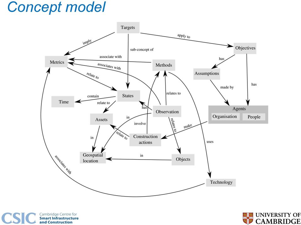
17 What are smart cities standards? Smart cities standard (PAS 182) offers a handful of generic concepts (such as place, observation, metric etc.) to formulate a common language for linking data across organizations in a city. The main goal is to seamlessly integrate information from multiple organisations using Linked Data (Semantic Web technology) that can be shared and edited. Different from BIM, Smart Cities allow for the sharing of critical but less tangible aspects that relate to the data: such as related Assumptions and Objectives.
 that can")
18 Concept model
19 Potential benefits? 1. Real-time infrastructure monitoring and prediction system save lives and infrastructure. 2. A smart framework that can correlate sensor data with design and analysis to understand the interactions between infrastructures and people Better engineering understanding 3. Multiple organizations/public benefit from gathered data that is in a universal format and organically linked to other critical information 4. Improve communication between agents by uniformly representing data/related aspects (eliminate redundancies and misunderstandings)


20 Bristol Air Pollution Measurement

21 Temporal RDF Temporal RDF extends the RDF statement from a triple to a quad where the fourth element is the valid time of the RDF statement
22 Time Slices
 Key value 12:00 53.5 mm 12:05 53.6 mm 12:10 53.")
23 Graph processing Property graph Sensor (WSN-#42) measures Since Sep 15 Measurement (displacement) Key value 12: mm 12: mm 12: mm
24 Optimisation


25 Map Reduce (Batch Process) or In memory (real-time) computation? Map Reduce Batch processing Larger set of data to extract features and correlations In memory Real-time predictions Uses features and correlations from statistical analysis Works on a smaller set of data and focused output.
26 Future direction Applying Machine Learning algorithms such as deeplearning techniques to extract features and correlations. Real-time prediction of infrastructure behaviour based on statistical correlations and relationships. Transform the future of infrastructure through smarter information

27 Thank you!
Big Data Challenges in Infrastructure the problems of time and space
 Big Data Challenges in Infrastructure the problems of time and space Dr Jennifer Schooling Cambridge Centre for Smart Infrastructure and Construction Infrastructure Challenges Implications for Design Operation
Smart City Australia
 Smart City Australia Slaven Marusic Department of Electrical and Electronic Engineering The University of Melbourne, Australia ARC Research Network on Intelligent Sensors, Sensor Networks and Information
Climate Change Adaptation for London s Transport System
 Climate Change Adaptation for London s Transport System Helen Woolston London Climate Change Partnership, 1 Contents This presentation will cover: London Climate Change Partnership Climate Change Adaptation
BIG Big Data Public Private Forum
 DATA STORAGE Martin Strohbach, AGT International (R&D) THE DATA VALUE CHAIN Value Chain Data Acquisition Data Analysis Data Curation Data Storage Data Usage Structured data Unstructured data Event processing
Oracle Smart City Platform Managing Mobility
 Oracle Smart Platform Managing Mobility iemke idsingh Public Sector Solutions Director Sustainable Trending Topics #QualityOfLife Providing instruments that monitor, analyze and improve the residents quality
Integrated Platforms. Includes: - Environmental monitoring system - Integrated Traffic Management - Network Monitoring. Index. Purpose.
 Integrated Platforms Includes: - Environmental monitoring system - Integrated Traffic Management - Network Monitoring Index Purpose Description Relevance for Large Scale Events Options Technologies Impacts
Cityzenith s 5D Smart City platform empowers users with a simple way to make sense of the torrent of data in our cities, corporate
 5D Smart City Cityzenith s 5D Smart City platform empowers users with a simple way to make sense of the torrent of data in our cities, corporate campuses, and universities, revolutionizing the way we access,
STRUCTURAL HEALTH MONITORING AT ROME UNDERGROUND, ROMA, ITALY
 Ref: WhP_Rome_vA STRUCTURAL HEALTH MONITORING AT ROME UNDERGROUND, ROMA, ITALY WHITE PAPER Summary: This white paper shows how Structural Health Monitoring (SHM), helps to improve the quality in the construction
Getec. The Geo Structural Monitoring Experts
 Getec The Geo Structural Monitoring Experts Getec Getec specialises in providing instrumentation and monitoring solutions for a wide range of applications. We focus on producing reliable, repeatable data
Big Data Collection and Utilization for Operational Support of Smarter Social Infrastructure
 Hitachi Review Vol. 63 (2014), No. 1 18 Big Data Collection and Utilization for Operational Support of Smarter Social Infrastructure Kazuaki Iwamura Hideki Tonooka Yoshihiro Mizuno Yuichi Mashita OVERVIEW:
Sensor Devices and Sensor Network Applications for the Smart Grid/Smart Cities. Dr. William Kao
 Sensor Devices and Sensor Network Applications for the Smart Grid/Smart Cities Dr. William Kao Agenda Introduction - Sensors, Actuators, Transducers Sensor Types, Classification Wireless Sensor Networks
Standards for Big Data in the Cloud
 Standards for Big Data in the Cloud International Cloud Symposium 15/10/2013 Carola Carstens (Project Officer) DG CONNECT, Unit G3 Data Value Chain European Commission Outline 1) Data Value Chain Unit
Big Data and Analytics: Getting Started with ArcGIS. Mike Park Erik Hoel
 Big Data and Analytics: Getting Started with ArcGIS Mike Park Erik Hoel Agenda Overview of big data Distributed computation User experience Data management Big data What is it? Big Data is a loosely defined
Information Processing, Big Data, and the Cloud
 Information Processing, Big Data, and the Cloud James Horey Computational Sciences & Engineering Oak Ridge National Laboratory Fall Creek Falls 2010 Information Processing Systems Model Parameters Data-intensive
Craig McWilliams Craig Burrell. Bringing Smarter, Safer Transport to NZ
 Craig McWilliams Craig Burrell Bringing Smarter, Safer Transport to NZ World Class Transport. Smarter, Stronger, Safer. Bringing Smarter Safer Transport to NZ Craig Burrell Infrastructure Advisory Director
Trends and Research Opportunities in Spatial Big Data Analytics and Cloud Computing NCSU GeoSpatial Forum
 Trends and Research Opportunities in Spatial Big Data Analytics and Cloud Computing NCSU GeoSpatial Forum Siva Ravada Senior Director of Development Oracle Spatial and MapViewer 2 Evolving Technology Platforms
Industry 4.0 and Big Data
 Industry 4.0 and Big Data Marek Obitko, mobitko@ra.rockwell.com Senior Research Engineer 03/25/2015 PUBLIC PUBLIC - 5058-CO900H 2 Background Joint work with Czech Institute of Informatics, Robotics and
IP-S2 Compact+ 3D Mobile Mapping System
 IP-S2 Compact+ 3D Mobile Mapping System 3D scanning of road and roadside features Delivers high density point clouds and 360 spherical imagery High accuracy IMU options without export control Simple Map,
Cycle Network Modelling A new evidence-based approach to the creation of cycling strategy
 Cycle Network Modelling A new evidence-based approach to the creation of cycling strategy A The Business Cycle, London, mapping of commuter cycle routes and hotspots, 2000. A It is refreshing to see an
Go with the flow: Transportation information management solutions from IBM.
 IBM Government Industry Solution Brief Smarter Transportation Go with the flow: Transportation information management solutions from IBM. Highlights: Extend the life of your transportation assets, optimize
ASSESSMENT OF VISUALIZATION SOFTWARE FOR SUPPORT OF CONSTRUCTION SITE INSPECTION TASKS USING DATA COLLECTED FROM REALITY CAPTURE TECHNOLOGIES
 ASSESSMENT OF VISUALIZATION SOFTWARE FOR SUPPORT OF CONSTRUCTION SITE INSPECTION TASKS USING DATA COLLECTED FROM REALITY CAPTURE TECHNOLOGIES ABSTRACT Chris Gordon 1, Burcu Akinci 2, Frank Boukamp 3, and
BIG DATA & ANALYTICS. Transforming the business and driving revenue through big data and analytics
 BIG DATA & ANALYTICS Transforming the business and driving revenue through big data and analytics Collection, storage and extraction of business value from data generated from a variety of sources are
PSG College of Technology, Coimbatore-641 004 Department of Computer & Information Sciences BSc (CT) G1 & G2 Sixth Semester PROJECT DETAILS.
 G1 & G2 Sixth Semester PROJECT DETAILS.") PSG College of Technology, Coimbatore-641 004 Department of Computer & Information Sciences BSc (CT) G1 & G2 Sixth Semester PROJECT DETAILS Project Project Title Area of Abstract No Specialization 1. Software
PSG College of Technology, Coimbatore-641 004 Department of Computer & Information Sciences BSc (CT) G1 & G2 Sixth Semester PROJECT DETAILS Project Project Title Area of Abstract No Specialization 1. Software
Complexity and Scalability in Semantic Graph Analysis Semantic Days 2013
 Complexity and Scalability in Semantic Graph Analysis Semantic Days 2013 James Maltby, Ph.D 1 Outline of Presentation Semantic Graph Analytics Database Architectures In-memory Semantic Database Formulation
BRIDGE OWNERS FORUM CHALLENGES 2007/8. What preoccupies bridge owners/managers and what researchers can do for them?
 BRIDGE OWNERS FORUM CHALLENGES 2007/8 What preoccupies bridge owners/managers and what researchers can do for them? INVITATION TO SUBMIT RESEARCH PROPOSALS This paper identifies challenges facing bridge
Big Data, Little Data, Real-Time Streaming & Smart Cities
 Wednesday 12 th Nov 2015 Big Data, Little Data, Real-Time Streaming & Smart Cities Michael Batty Centre for Advanced Spatial Analysis CASA-UCL m.batty@ucl.ac.uk @jmichaelbatty Themes in My Lecture Future
Integrated Remote System for Monitoring Point Machines. Rationalize preventive maintenance and reduce costs
 Integrated Remote System for Monitoring Point Machines Rationalize preventive maintenance and reduce costs Background & Introduction: Traditional monitoring is currently being reinvented to meet today
Traffic Management for a Smarter City:Istanbul Istanbul Metropolitan Municipality
 Traffic Management for a Smarter City:Istanbul Istanbul Metropolitan Municipality Traffic Management for a Smarter City: Istanbul There is no doubt for Traffic Management to be an issue in a crowded city
GIS Solutions for FTTx Design. David Nelson, GISP
 GIS Solutions for FTTx Design David Nelson, GISP Telecom GIS Manager, Black & Veatch Agenda Intro to GIS Telecom GIS Vision GIS Strategy Project Execution Mobile Online Services Dashboards Client Deliverables
Smart Cambridge. Smart Cambridge
 1 Contents Smart Cambridge What is a smart city? 3 How smart is Cambridge already? 4 What does it mean for residents? 5 Smart City Management Platform 6 What are our next steps? 7 World-class innovation
CONGESTION AND INCIDENT MANGEMENT APPLICATIONS FOR DISTRIBUTED ACOUSTIC SENSING TECHNOLOGY NZTA CASE STUDY
 CONGESTION AND INCIDENT MANGEMENT APPLICATIONS FOR DISTRIBUTED ACOUSTIC SENSING TECHNOLOGY NZTA CASE STUDY Authors Russell Pinchen, Senior ITS Engineer, New Zealand Transport Agency, 1 Queen Street, Auckland
Use of GIS in Planning and Asset Management
 Use of GIS in Planning and Asset Management Technology Developments and Practical Uses Jay Adams Oklahoma DOT Pam Jurney Cross Timbers Consulting GIS Is Evolving Rapidly Millions Organizations 100 s
IP-S2 HD. High Definition 3D Mobile Mapping System
 IP-S2 HD High Definition 3D Mobile Mapping System Integrated, turnkey solution High Density, Long Range LiDAR sensor for ultimate in visual detail High Accuracy IMU and DMI Odometry for positional accuracy
BIG. Big Data Analysis John Domingue (STI International and The Open University) Big Data Public Private Forum
 Big Data Public Private Forum") Big Data Analysis John Domingue (STI International and The Open University) Project co-funded by the European Commission within the 7th Framework Program (Grant Agreement No. 257943) 1 The Data landscape
Big Data Analysis John Domingue (STI International and The Open University) Project co-funded by the European Commission within the 7th Framework Program (Grant Agreement No. 257943) 1 The Data landscape
Using the HP Vertica Analytics Platform to Manage Massive Volumes of Smart Meter Data
 Technical white paper Using the HP Vertica Analytics Platform to Manage Massive Volumes of Smart Meter Data The Internet of Things is expected to connect billions of sensors that continuously gather data
LOAD TESTING OF SOME NEW BRIDGES IN LATVIA
 LOAD TESTING OF SOME NEW BRIDGES IN LATVIA Edmunds Akimovs, Civ.Eng., Bridge Engineer, Consulting Company Inzenierbuve, Address: Azenes st. 20, Riga, LV1048, Latvia. E-mail: eakimovs@inzenierbuve.lv Ainars
redesigning the data landscape to deliver true business intelligence Your business technologists. Powering progress
 redesigning the data landscape to deliver true business intelligence Your business technologists. Powering progress The changing face of data complexity The storage, retrieval and management of data has
CABLE ASSET MANAGEMENT PREDICT WITH CERTAINTY. Kuljit Singh BSc Honours MIEE(IET,UK) 5 June 2014
 5 June 2014") CABLE ASSET MANAGEMENT PREDICT WITH CERTAINTY Kuljit Singh BSc Honours MIEE(IET,UK) 5 June 2014 Definitions International Workshop 2014 DTS: Distributed Temperature Sensor DCR: Dynamic Cable Ratings (
CABLE ASSET MANAGEMENT PREDICT WITH CERTAINTY Kuljit Singh BSc Honours MIEE(IET,UK) 5 June 2014 Definitions International Workshop 2014 DTS: Distributed Temperature Sensor DCR: Dynamic Cable Ratings (
Application Architectures
 Software Engineering Application Architectures Based on Software Engineering, 7 th Edition by Ian Sommerville Objectives To explain the organization of two fundamental models of business systems - batch
USING MOBILE LIDAR TO SURVEY A RAILWAY LINE FOR ASSET INVENTORY INTRODUCTION
 USING MOBILE LIDAR TO SURVEY A RAILWAY LINE FOR ASSET INVENTORY a Michael Leslar, Sales and Marketing Support Engineer b Gordon Perry, Senior Project Manager b Keith McNease, Principal a Optech Incorporated
high performance solutions for a connected world
 GE Intelligent Platforms delivers high performance solutions for a connected world Mark Pipher GM, Real Time Operational Intelligence Sources: 1. Wall Street Journal, 11/2/11; 2. More than 50 billion connected
PUSH INTELLIGENCE. Bridging the Last Mile to Business Intelligence & Big Data. 2013 Copyright Metric Insights, Inc.
 PUSH INTELLIGENCE Bridging the Last Mile to Business Intelligence & Big Data 2013 Copyright Metric Insights, Inc. INTRODUCTION... 3 CHALLENGES WITH BI... 4 The Dashboard Dilemma... 4 Architectural Limitations
The complete provider for. Gauging Products and Measurement Systems
 The complete provider for Gauging Products and Measurement Systems The Gauging Requirement Effective clearance assessment is something that concerns all railways and demands for significantly increased
Emerging Geospatial Trends The Convergence of Technologies. Jim Steiner Vice President, Product Management
 Emerging Geospatial Trends The Convergence of Technologies Jim Steiner Vice President, Product Management United Nation Analysis Initiative on Global GeoSpatial Information Management Future Trends Technology
Where is... How do I get to...
 Big Data, Fast Data, Spatial Data Making Sense of Location Data in a Smart City Hans Viehmann Product Manager EMEA ORACLE Corporation August 19, 2015 Copyright 2014, Oracle and/or its affiliates. All rights
Smart Cities require Geospatial Data Providing services to citizens, enterprises, visitors...
 Cloud-based Spatial Data Infrastructures for Smart Cities Geospatial World Forum 2015 Hans Viehmann Product Manager EMEA ORACLE Corporation Smart Cities require Geospatial Data Providing services to citizens,
TfL Corporate Archives Research Guides
 TfL Corporate Archives Research Guides Research Guide No 15: Health Safety Records The Transport for London Corporate Archives has a substantial amount of material which relates to safety issues. The following
White Paper. Sensor Technologies for the Protection of remote assets
 White Paper Sensor Technologies for the Protection of remote assets In today s complex geopolitical environment, Government Agencies and Public Bodies have a responsibility to provide protection and resilience
TRIMBLE RAILWAY SOLUTIONS INNOVATION TO DELIVER SAFETY, ACCURACY AND EFFICIENCY
 TRIMBLE RAILWAY SOLUTIONS INNOVATION TO DELIVER SAFETY, ACCURACY AND EFFICIENCY AN INDUSTRY BUILT ON MOTION TRIMBLE RAILWAY SOLUTIONS COMBINE MEASUREMENT WITH DATA MANAGEMENT, COMMUNICATIONS AND CUSTOMIZED
HIGH-PERFORMANCE INSPECTION VEHICLE FOR RAILWAYS AND TUNNEL LININGS. HIGH-PERFORMANCE INSPECTION VEHICLE FOR RAILWAY AND ROAD TUNNEL LININGS.
 HIGH-PERFORMANCE INSPECTION VEHICLE FOR RAILWAYS AND TUNNEL LININGS. HIGH-PERFORMANCE INSPECTION VEHICLE FOR RAILWAY AND ROAD TUNNEL LININGS. The vehicle developed by Euroconsult and Pavemetrics and described
Monitoring and Mining Sensor Data in Cloud Computing Environments
 Monitoring and Mining Sensor Data in Cloud Computing Environments Wen-Chih Peng and Yu-Chee Tseng Dept. of Computer Science National Chiao Tung University {wcpeng, yctseng}@cs.nctu.edu.tw 1 Outline Sensor
Innovation: Add Predictability to an Unpredictable World
 Innovation: Add Predictability to an Unpredictable World Improve Visibility and Control of Your Telecom Network Judith Hurwitz President and CEO Sponsored by Hitachi Data Systems Introduction It is all
Designing Industrial Network - An Approach
 Designing Industrial Network - An Approach Happiest People Happiest Customers Contents Abstract...3 Introduction...3 What is Industrial networking?...4 Industrial Network Design consideration....4 Industrial
Social Innovation through Utilization of Big Data
 Social Innovation through Utilization of Big Data Hitachi Review Vol. 62 (2013), No. 7 384 Shuntaro Hitomi Keiro Muro OVERVIEW: The analysis and utilization of large amounts of actual operational data
INTEGRATING BIM AND GIS FOR ASSET MANAGEMENT
 INTEGRATING BIM AND GIS FOR ASSET MANAGEMENT Andy Chan MHKIBIM Project Manager Spatial Technology Limited Agenda Introduction of Asset Management Why GIS is not sufficient for Asset Management Data model
Engr. M. Fahad Khan Lecturer Software Engineering Department University Of Engineering & Technology Taxila
 Engr. M. Fahad Khan Lecturer Software Engineering Department University Of Engineering & Technology Taxila Application Architectures Ref: Chapter 13 Software Engineering By Ian Sommerville, 7th Edition
Smart Solutions for Cities. R. Chandrashekhar President 25th June 2015
 Smart Solutions for Cities R. Chandrashekhar President 25th June 2015 Making Cities Smart To make Cities in India Smart we need an integrated approach to modernize city infrastructure, and leverage technology
Network Intelligence Driven Cloud Services for a Sustainable Connected World. Fahim Kawsar Internet of Things Research Bell Labs @raswak
 Network Intelligence Driven Cloud Services for a Sustainable Connected World Fahim Kawsar Internet of Things Research Bell Labs @raswak MORE DEVELOPED COUNTRIES 2013: 1.2 Billion 2050: 1.3 Billion WORLD
Seminar on Polish & Danish Experiences June 2th 2015
 KMD Master Data KMD Master data management - Master data interoperability Seminar on Polish & Danish Experiences June 2th 2015 Nicolas Horst, Domain executive Lead AGENDA JUNE 2th 1. Trends and overview
Data-intensive HPC: opportunities and challenges. Patrick Valduriez
 Data-intensive HPC: opportunities and challenges Patrick Valduriez Big Data Landscape Multi-$billion market! Big data = Hadoop = MapReduce? No one-size-fits-all solution: SQL, NoSQL, MapReduce, No standard,
Agent-based dam monitoring
 Agent-based dam monitoring V. BETTZIECHE, Ruhrverband (Ruhr River Association), Essen, GER SYNOPSIS. The monitoring of security relevant structures is a task of growing importance in civil engineering.
City Management Platform Using Big Data from People and Traffic Flows
 52 Hitachi Review Vol. 64 (2015), No. 1 Featured Articles City Management Platform Using Big Data from People and Traffic Flows Michio Morioka, Ph.D. Kyoji Kuramochi Yusuke Mishina Takayuki Akiyama Naoyuki
Monitoring of Tunnel End Plug Performance in ONKALO
 Monitoring of Tunnel End Plug Performance in ONKALO Erika Holt, VTT Technical Research Centre of Finland Presentation at IGDTP-Geodisposal 2014 Manchester, UK, 24th to 26th of June 2014 Co-authors: I.
Internet of Things (IoT): A vision, architectural elements, and future directions
: A vision, architectural elements, and future directions") SeoulTech UCS Lab 2014-2 st Internet of Things (IoT): A vision, architectural elements, and future directions 2014. 11. 18 Won Min Kang Email: wkaqhsk0@seoultech.ac.kr Table of contents Open challenges
SeoulTech UCS Lab 2014-2 st Internet of Things (IoT): A vision, architectural elements, and future directions 2014. 11. 18 Won Min Kang Email: wkaqhsk0@seoultech.ac.kr Table of contents Open challenges
GPS Excavation Monitoring Solution. Design Session
 GPS Excavation Monitoring Solution Design Session Overview Problem Statement Performance Requirements Workflow Excavation Monitoring Hardware Software Platform Analytics Notification and Viewing Problem
HOW TO DO A SMART DATA PROJECT
 April 2014 Smart Data Strategies HOW TO DO A SMART DATA PROJECT Guideline www.altiliagroup.com Summary ALTILIA s approach to Smart Data PROJECTS 3 1. BUSINESS USE CASE DEFINITION 4 2. PROJECT PLANNING
Pipeline External Corrosion Analysis Using a 3D Laser Scanner
 Pipeline Technology Conference 2013 Pipeline External Corrosion Analysis Using a 3D Laser Scanner Pierre-Hugues ALLARD, Charles MONY Creaform, www.creaform3d.com 5825 rue St-Georges, Lévis (QC), Canada,
Automotive Applications of 3D Laser Scanning Introduction
 Automotive Applications of 3D Laser Scanning Kyle Johnston, Ph.D., Metron Systems, Inc. 34935 SE Douglas Street, Suite 110, Snoqualmie, WA 98065 425-396-5577, www.metronsys.com 2002 Metron Systems, Inc
Value of Instrumentation Systems and Real-Time Monitoring: An Owner s Perspective
 Value of Instrumentation Systems and Real-Time Monitoring: An Owner s Perspective FHWA NATIONAL GEOTECHNICAL PROGRAM www.fhwa.dot.gov/engineering/geotech Why Geotechnical Instrumentation? Provide warning
The Internet of Things. Giles Norman MobileFirst Consulting Manager, IBM. Daniel Dombach Director EMEA, Industry Solutions, Zebra Technologies
 The Internet of Things Giles Norman MobileFirst Consulting Manager, IBM Daniel Dombach Director EMEA, Industry Solutions, Zebra Technologies Internet of Things Daniel Dombach Director EMEA Industry Solutions
High rate and Switched WiFi. WiFi 802.11 QoS, Security 2G. WiFi 802.11a/b/g. PAN LAN Cellular MAN
 Security Issues and Quality of Service in Real Time Wireless PLC/SCADA Process Control Systems Dr. Halit Eren & Dincer Hatipoglu Curtin University of Technology (Perth Australia) 2/27/2008 1 PRESENTATION
Evolving Bar Codes. Y398 Internship. William Holmes
 Evolving Bar Codes Y398 Internship By William Holmes Table of contents Introduction: What is RFID? Types of Tags: Advantages of Tags: RFID applications Conclusion: Introduction: Bar codes have evolved
Game Changing Analytics to the Explosion of Video
 Game Changing Analytics to the Explosion of Video What is the next level of Video and Data Analytics? Smarter Safer Communities Impact of Social Media End-to End Solution Objective: Safer, Smarter, More
BIG DATA IN THE CLOUD : CHALLENGES AND OPPORTUNITIES MARY- JANE SULE & PROF. MAOZHEN LI BRUNEL UNIVERSITY, LONDON
 BIG DATA IN THE CLOUD : CHALLENGES AND OPPORTUNITIES MARY- JANE SULE & PROF. MAOZHEN LI BRUNEL UNIVERSITY, LONDON Overview * Introduction * Multiple faces of Big Data * Challenges of Big Data * Cloud Computing
Laser Scanning Surveying and Ground Penetrating Radar The Full Three Dimensional Picture Above and Below Ground
 Laser Scanning Surveying and Ground Penetrating Radar The Full Three Dimensional Picture Above and Below Ground CIVILEX 2009 Mark Hudson, Director, Coastway, FInstCES MRICS MIS BTS Jeff Hott, Laser Scanning
Smart City Live! 9-10 May 2016, Nice
 Monday, May 9, 2016 Smart City Live! 9-10 May 2016, Nice Draft agenda as of November 20, 2015 SMART LIVING SMART CITY SERVICES 9:00 AM CASE STUDY: Developing Smart Energy communities Understanding the
Industrial Internet, Internet of Things and Big Data: business issues pure players vs bricks & mortars
 Industrial Internet, Internet of Things and Big Data: business issues pure players vs bricks & mortars Guillaume CHELIUS CEO www.hikob.com HIKOB background Company background Creation: 4th of July 2011
in Health Care and Sensor Networks
 16 th FFV Workshop Web Services in Health Care and Sensor Networks Fahad Aijaz Department of Communication Networks RWTH Aachen University, Germany FFV Workshop, March 13, 2009 Outline Wireless Sensor
A geospatial relational database schema for interdependent network analysis and modelling
 A geospatial relational database schema for interdependent network analysis and modelling David Alderson *1, Stuart Barr 1, Tomas Holderness 2, Craig Robson^1, Alistair Ford #1 and Ruth Kennedy-Walker
ETP 2010 Conference Urban Mobility the door-to. to-door strategy
 ETP 2010 Conference Urban Mobility the door-to to-door strategy Prof. George Giannopoulos Centre for Research and Technology Hellas, Hellenic Institute of Transport Email: ggian@certh.gr Web: www.hit.certh.gr
Industrial Roadmap for Connected Machines. Sal Spada Research Director ARC Advisory Group sspada@arcweb.com
 Industrial Roadmap for Connected Machines Sal Spada Research Director ARC Advisory Group sspada@arcweb.com Industrial Internet of Things (IoT) Based upon enhanced connectivity of this stuff Connecting
Innovative capture and modeling of existing building conditions using 3D laser scanning. Entry B Submission
 Innovative capture and modeling of existing building conditions using 3D laser scanning Entry B Submission Executive Summary As a large owner organization, understanding and developing new technologies
Advanced Analytics. The Way Forward for Businesses. Dr. Sujatha R Upadhyaya
 Advanced Analytics The Way Forward for Businesses Dr. Sujatha R Upadhyaya Nov 2009 Advanced Analytics Adding Value to Every Business In this tough and competitive market, businesses are fighting to gain
Probes and Big Data: Opportunities and Challenges
 Probes and Big Data: Opportunities and Challenges Fiona Calvert, Director Information Services and Mapping, Department of Transport Planning and Local Infrastructure New data sources, probes and big data
Big Data Processing and Analytics for Mouse Embryo Images
 Big Data Processing and Analytics for Mouse Embryo Images liangxiu han Zheng xie, Richard Baldock The AGILE Project team FUNDS Research Group - Future Networks and Distributed Systems School of Computing,
WWW.WIPRO.COM THE INTERNET OF THINGS. HARMONIZING IoT FOR RETAIL. Kuru Subramaniam
 WWW.WIPRO.COM THE INTERNET OF THINGS HARMONIZING IoT FOR RETAIL Kuru Subramaniam Table of contents 01 Abstract 01 Introduction 02 Where Are We Headed? 02 What Does IoT Mean for Retailers? 03 Getting the
Track and Track Drainage Renewals Programme
 Board Date: 26 March 2015 Item 14: Track and Track Drainage Renewals Programme This paper will be considered in public 1 Summary Track and Track Drainage Renewals Programme Existing Estimated Existing
Five Essential Components for Highly Reliable Data Centers
 GE Intelligent Platforms Five Essential Components for Highly Reliable Data Centers Ensuring continuous operations with an integrated, holistic technology strategy that provides high availability, increased
Ground-borne Vibrations and Ground Settlements Arising from Pile Driving and Similar Operations
 Buildings Department Practice Note for Authorized Persons, Registered Structural Engineers and Registered Geotechnical Engineers APP-137 Ground-borne Vibrations and Ground Settlements Arising from Pile
CCTV - Video Analytics for Traffic Management
 CCTV - Video Analytics for Traffic Management Index Purpose Description Relevance for Large Scale Events Technologies Impacts Integration potential Implementation Best Cases and Examples 1 of 12 Purpose
Big Data and Complex Networks Analytics. Timos Sellis, CSIT Kathy Horadam, MGS
 Big Data and Complex Networks Analytics Timos Sellis, CSIT Kathy Horadam, MGS Big Data What is it? Most commonly accepted definition, by Gartner (the 3 Vs) Big data is high-volume, high-velocity and high-variety
Digital Cities: Open Data Developments in New York, London and Hong Kong
 Digital Cities: Open Data Developments in New York, London and Hong Kong By Waltraut Ritter Hong Kong likes to compare itself to New York and London, but when it comes to opening up public data for digital
Asset Management Policy March 2014
 Asset Management Policy March 2014 In February 2011, we published our current Asset Management Policy. This is the first update incorporating further developments in our thinking on capacity planning and
Testing Big data is one of the biggest
 Infosys Labs Briefings VOL 11 NO 1 2013 Big Data: Testing Approach to Overcome Quality Challenges By Mahesh Gudipati, Shanthi Rao, Naju D. Mohan and Naveen Kumar Gajja Validate data quality by employing
Research Article ISSN 2277 9140 Copyright by the authors - Licensee IJACIT- Under Creative Commons license 3.0
 INTERNATIONAL JOURNAL OF ADVANCES IN COMPUTING AND INFORMATION TECHNOLOGY An international, online, open access, peer reviewed journal Volume 2 Issue 2 April 2013 Research Article ISSN 2277 9140 Copyright
Enable Location-based Services with a Tracking Framework
 Enable Location-based Services with a Tracking Framework Mareike Kritzler University of Muenster, Institute for Geoinformatics, Weseler Str. 253, 48151 Münster, Germany kritzler@uni-muenster.de Abstract.
Ulyxes automatic deformation monitoring system
 Ulyxes automatic deformation monitoring system Dániel Moka, Szonja Zemkó (Hungary) The CLGE Students Contest 2012 2013 Category: GIS and Mapping and Cadastre 1. Summary We live in a dynamic world. Buildings,
Big Data and Semantic Web in Manufacturing. Nitesh Khilwani, PhD Chief Engineer, Samsung Research Institute Noida, India
 Big Data and Semantic Web in Manufacturing Nitesh Khilwani, PhD Chief Engineer, Samsung Research Institute Noida, India Outline Big data in Manufacturing Big data Analytics Semantic web technologies Case
HomeReACT a Tool for Real-time Indoor Environmental Monitoring
 HomeReACT a Tool for Real-time Indoor Environmental Monitoring Tessa Daniel, Elena Gaura, James Brusey Cogent Computing Applied Research Centre Faculty of Engineering and Computing Coventry University,