massive aerial LiDAR point clouds
|
|
|
- Aleesha Parrish
- 10 years ago
- Views:
Transcription

1 Visualization, storage, analysis and distribution of massive aerial LiDAR point clouds Gerwin de Haan and Hugo Ledoux Data Visualization group GIS technology group GeoWeb 2010, Vancouver July / 30

2 AHN 2 : A dataset covering totally the Netherlands compiled by the government (x, y, z) points raster (50cm grid available) at least 4 pts/m 2 > 150 billions points 2 / 30

3 AHN 2 : A tiled dataset 3 / 30


4 AHN 2 : A tiled dataset 3 / 30

5 File g37en1 08.xyz , , , , , , , , , , , , , , , , , , , , / 30

6 Our challenges when dealing with massive point clouds 1 Real-time visualisation 2 Storage + spatial analysis 3 Distribution of such datasets Can our tools/workflows scale to massive datasets? 5 / 30

7 Real-time Visualisation 6 / 30

8 Why visualise point clouds? Because it s a nice challenge! Because we need to: Perform visual inspection of raw measurements Gain insights from numbers Rendering Visualisation Interaction 7 / 30


9 From DEM terrain... (AHN2 DEM 0.5m grid) 8 / 30

")
10 ... to point cloud ( 2 millions points from AHN2 ) 9 / 30

11 Our tools of choice OpenSceneGraph most popular FOSS scene graph engine based on flight-simulator software (not GIS) OpenSceneGraph-based VRMeer software Python abstraction layers 10 / 30


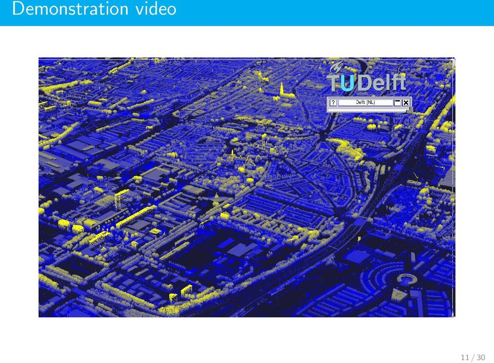
12 Demonstration video 11 / 30
13 Visualisation pipeline overview Point Cloud Server Real-Time Visualization Client LiDAR Offline LOD generator Data Server LOD tiles network Database Pager Thread display Visualization Thread 12 / 30

14 Multi-resolution data struture L1 L1 L0 L0 L0 L0 L1 L2 L1 Ln 13 / 30

15 Multi-resolution data struture Split LOD0 LOD1 LOD2 Merge LOD3... LOD N 13 / 30

16 LOD effects 14 / 30


17 Interaction Stereoscopic display 3D interaction with space-mouse, Wii balance board interaction More info: PhD thesis Techniques and Architectures for 3D Interaction, Gerwin de Haan, TU Delft, / 30

18 Interaction 16 / 30

19 Analysis & Storage 17 / 30
20 Point clouds are often 2.5D surface LiDAR datasets are formed by scattered points in 3D space, which are the samples of a surface that can be projected on the horizontal plan. 18 / 30

21 Reconstruction of the surface Original LiDAR points 19 / 30
22 Reconstruction of the surface Raster representation 19 / 30
23 Reconstruction of the surface Raster representation 19 / 30
24 Reconstruction of the surface Original LiDAR points 19 / 30
25 Reconstruction of the surface TIN (with Delaunay triangles) 19 / 30
26 Reconstruction of the surface p TIN (with Delaunay triangles) 19 / 30
27 Reconstruction of the surface a f b c p e d TIN (with Delaunay triangles) 19 / 30
28 A star-based data structure Goes beyond the usual store points and edges/triangles Ideas come from data structures for compression of graphs p 20 / 30
29 A star-based data structure Goes beyond the usual store points and edges/triangles Ideas come from data structures for compression of graphs a f b c p e d 20 / 30
30 A star-based data structure Goes beyond the usual store points and edges/triangles Ideas come from data structures for compression of graphs a f b c p e d 20 / 30
31 A star-based data structure Goes beyond the usual store points and edges/triangles Ideas come from data structures for compression of graphs a f b c p e star(p) = abcdef d 20 / 30
32 Every star(v) is stored implicit triangles 21 / 30
33 Every star(v) is stored implicit triangles 21 / 30
34 Every star(v) is stored implicit triangles 21 / 30
35 Every star(v) is stored implicit triangles 21 / 30
36 Stars in a DBMS ID x y z star Advantages: 1 Only one table with id x y z star 2 No spatial index needed: fetching of triangles based on walking 3 Star column need not be filled ( Simple Features) 4 Local updates are possible (insertion and removals) 5 Ideas are readily extensible to 3D for storing manipulating tetrahedra 22 / 30
37 Point Location = Walking in the triangulation starting triangle p (Can be made efficient with some tricks [MSZ99]) 23 / 30
38 Range Queries: also uses the triangulation 24 / 30

39 One problem: how to create that DT in the first place? Figure from Martin Isenburg s presentation at GIScience 2006 [ILSS06] 25 / 30
40 Distribution of the Data 26 / 30
41 Velas3D: An online AHN 2 selector 27 / 30
42 Velas3D: An online AHN 2 selector 27 / 30

43 Velas3D: An online AHN 2 selector 28 / 30

44 Thanks for your attention Hugo Ledoux Gerwin de Haan 29 / 30
45 References Martin Isenburg, Yuanxin Liu, Jonathan Richard Shewchuk, and Jack Snoeyink. Streaming computation of Delaunay triangulations. ACM Transactions on Graphics, 25(3): , Ernst P. Mücke, Isaac Saias, and Binhai Zhu. Fast randomized point location without preprocessing in two- and three-dimensional Delaunay triangulations. Computational Geometry Theory and Applications, 12:63 83, / 30
Scalable visualization of massive point clouds
 Scalable visualization of massive point clouds G. de Haan TU Delft, Computer Graphics & CAD/CAM group, the Netherlands Abstract Graphical renderings of "raw" point clouds can be visually attractive. When
3D Data Management From Point Cloud to City Model GeoSmart Africa 2016, Cape Town
 3D Data Management From Point Cloud to City Model GeoSmart Africa 2016, Cape Town Albert Godfrind Spatial Solutions Architect ORACLE Corporation April 13, 2016 Copyright 2014 Oracle and/or its affiliates.
SECONDARY STORAGE TERRAIN VISUALIZATION IN A CLIENT-SERVER ENVIRONMENT: A SURVEY
 SECONDARY STORAGE TERRAIN VISUALIZATION IN A CLIENT-SERVER ENVIRONMENT: A SURVEY Kai Xu and Xiaofang Zhou School of Information Technology and Electrical Engineering The University of Queensland, Brisbane,
Databases for 3D Data Management: From Point Cloud to City Model
 Databases for 3D Data Management: From Point Cloud to City Model Xavier Lopez, Ph.D. Senior Director, Spatial and Graph Technologies Oracle Program Agenda Approach: Spatially-enable the Enterprise Oracle
Create a folder on your network drive called DEM. This is where data for the first part of this lesson will be stored.
 In this lesson you will create a Digital Elevation Model (DEM). A DEM is a gridded array of elevations. In its raw form it is an ASCII, or text, file. First, you will interpolate elevations on a topographic
CityGML goes to Broadway
 CityGML goes to Broadway Thomas H. Kolbe, Barbara Burger, Berit Cantzler Chair of Geoinformatics [email protected] September 11, 2015 Photogrammetric Week 2015, Stuttgart The New York City Open Data
<Insert Picture Here> Data Management Innovations for Massive Point Cloud, DEM, and 3D Vector Databases
 Data Management Innovations for Massive Point Cloud, DEM, and 3D Vector Databases Xavier Lopez, Director, Product Management 3D Data Management Technology Drivers: Challenges & Benefits
GIS Databases With focused on ArcSDE
 Linköpings universitet / IDA / Div. for human-centered systems GIS Databases With focused on ArcSDE Imad Abugessaisa [email protected] 20071004 1 GIS and SDBMS Geographical data is spatial data whose
A Method Using ArcMap to Create a Hydrologically conditioned Digital Elevation Model
 A Method Using ArcMap to Create a Hydrologically conditioned Digital Elevation Model High resolution topography derived from LiDAR data is becoming more readily available. This new data source of topography
Service-Oriented Visualization of Virtual 3D City Models
 Service-Oriented Visualization of Virtual 3D City Models Authors: Jan Klimke, Jürgen Döllner Computer Graphics Systems Division Hasso-Plattner-Institut, University of Potsdam, Germany http://www.hpi3d.de
GIS Data in ArcGIS. Pay Attention to Data!!!
 GIS Data in ArcGIS Pay Attention to Data!!! 1 GIS Data Models Vector Points, lines, polygons, multi-part, multi-patch Composite & secondary features Regions, dynamic segmentation (routes) Raster Grids,
MrSID Plug-in for 3D Analyst
 LizardTech MrSID Plug-in for 3D Analyst User Manual Copyrights Copyright 2009 2010 LizardTech. All rights reserved. Information in this document is subject to change without notice. The software described
Advanced Image Management using the Mosaic Dataset
 Esri International User Conference San Diego, California Technical Workshops July 25, 2012 Advanced Image Management using the Mosaic Dataset Vinay Viswambharan, Mike Muller Agenda ArcGIS Image Management
ERDAS IMAGINE The world s most widely-used remote sensing software package
 ERDAS IMAGINE The world s most widely-used remote sensing software package ERDAS IMAGINE Geographic imaging professionals need to process vast amounts of geospatial data every day often relying on software
CitusDB Architecture for Real-Time Big Data
 CitusDB Architecture for Real-Time Big Data CitusDB Highlights Empowers real-time Big Data using PostgreSQL Scales out PostgreSQL to support up to hundreds of terabytes of data Fast parallel processing
LIDAR and Digital Elevation Data
 LIDAR and Digital Elevation Data Light Detection and Ranging (LIDAR) is being used by the North Carolina Floodplain Mapping Program to generate digital elevation data. These highly accurate topographic
Point cloud data management Peter van Oosterom, Siva Ravada, Mike Horhammer, Oscar Marinez Rubi, Milena Ivanova, Martin Kodde and Theo Tijssen
 Extended abstract for the invited presentation at the IQmulus Workshop on Processing Large Geospatial Data, 8 July 2014, Cardiff, Wales, UK (version 23 May 2014) Point cloud data management Peter van Oosterom,
ADVANCED DATA STRUCTURES FOR SURFACE STORAGE
 1Department of Mathematics, Univerzitni Karel, Faculty 22, JANECKA1, 323 of 00, Applied Pilsen, Michal, Sciences, Czech KARA2 Republic University of West Bohemia, ADVANCED DATA STRUCTURES FOR SURFACE STORAGE
1. INTRODUCTION Graphics 2
 1. INTRODUCTION Graphics 2 06-02408 Level 3 10 credits in Semester 2 Professor Aleš Leonardis Slides by Professor Ela Claridge What is computer graphics? The art of 3D graphics is the art of fooling the
Parallel Simplification of Large Meshes on PC Clusters
 Parallel Simplification of Large Meshes on PC Clusters Hua Xiong, Xiaohong Jiang, Yaping Zhang, Jiaoying Shi State Key Lab of CAD&CG, College of Computer Science Zhejiang University Hangzhou, China April
ArcGIS 10.1 Geodatabase Administration. Gordon Sumerling & Christopher Brown
 ArcGIS 10.1 Geodatabase Administration Gordon Sumerling & Christopher Brown Key Improvements at ArcGIS 10.1 1. Easier Administration through Graphic Interfaces 2. Greater Seamless integration with Open
3D web visualization of huge CityGML models
 3D web visualization of huge CityGML models F. Prandi, F. Devigili, M. Soave, U. Di Staso, R. De Amicis Fondzione Graphitech, Via alla Cascata 56/c, 28123 Trento, Italy Introduction The big offer of raw
GEOGRAPHIC INFORMATION SYSTEMS
 GEOGRAPHIC INFORMATION SYSTEMS WHAT IS A GEOGRAPHIC INFORMATION SYSTEM? A geographic information system (GIS) is a computer-based tool for mapping and analyzing spatial data. GIS technology integrates
EIVA NaviModel3. Efficient Sonar Data Cleaning. Implementation of the S-CAN Automatic Cleaning Algorithm in EIVAs NaviModel3. Lars Dall, EIVA A/S
 EIVA NaviModel3 Efficient Sonar Data Cleaning Implementation of the S-CAN Automatic Cleaning Algorithm in EIVAs NaviModel3 Lars Dall, EIVA A/S Contents: Introduction to NaviModel3 Cleaning functionalities
Web-Based Enterprise Data Visualization a 3D Approach. Oleg Kachirski, Black and Veatch
 Web-Based Enterprise Data Visualization a 3D Approach Oleg Kachirski, Black and Veatch Contents - Introduction - Why 3D? - Applications of 3D - 3D Content Authoring - 3D/4D in GIS - Challenges of Presenting
Technologies Enabling the Evolution of a Smart City. Brad Schmidt, Intergraph Canada
 Technologies Enabling the Evolution of a Smart City Brad Schmidt, Intergraph Canada AGENDA The Smart City Key Challenges Facing Cities Technology Challenges Smart Sensor Integration Smart Apps Smart Data
AN STUDY ON DATA CONSISTENCY IN SPATIAL DATABASE SYSTEM
 AN STUDY ON DATA CONSISTENCY IN SPATIAL DATABASE SYSTEM Zhu Xinyan Li Deren Gong Jianya National Laboratory of Information Engineering in Surveying, Mapping and Remote Sensing Wuhan Technical University
LAR-IAC4 Status and User Group Meeting. October 8, 2015
 LAR-IAC4 Status and User Group Meeting October 8, 2015 Agenda LARIAC Imagery Update LARIAC Status Update LARIAC Update and Training Schedule LARIAC Data Access Methods Additional Derived Data User Presentations
3D MODELING OF LARGE AND COMPLEX SITE USING MULTI-SENSOR INTEGRATION AND MULTI-RESOLUTION DATA
 3D MODELING OF LARGE AND COMPLEX SITE USING MULTI-SENSOR INTEGRATION AND MULTI-RESOLUTION DATA G. Guidi 1, F. Remondino 2, 3, M. Russo 1, F. Menna 4, A. Rizzi 3 1 Dept.INDACO, Politecnico of Milano, Italy
Location tracking: technology, methodology and applications
 Location tracking: technology, methodology and applications Marina L. Gavrilova SPARCS Laboratory Co-Director Associate Professor University of Calgary Interests and affiliations SPARCS Lab Co-Founder
GPU Architecture. Michael Doggett ATI
 GPU Architecture Michael Doggett ATI GPU Architecture RADEON X1800/X1900 Microsoft s XBOX360 Xenos GPU GPU research areas ATI - Driving the Visual Experience Everywhere Products from cell phones to super
STATE OF NEVADA Department of Administration Division of Human Resource Management CLASS SPECIFICATION
 STATE OF NEVADA Department of Administration Division of Human Resource Management CLASS SPECIFICATION TITLE PHOTOGRAMMETRIST/CARTOGRAPHER V 39 6.102 PHOTOGRAMMETRIST/CARTOGRAPHER II 33 6.110 PHOTOGRAMMETRIST/CARTOGRAPHER
Files Used in this Tutorial
 Generate Point Clouds Tutorial This tutorial shows how to generate point clouds from IKONOS satellite stereo imagery. You will view the point clouds in the ENVI LiDAR Viewer. The estimated time to complete
NVIDIA IndeX Enabling Interactive and Scalable Visualization for Large Data Marc Nienhaus, NVIDIA IndeX Engineering Manager and Chief Architect
 SIGGRAPH 2013 Shaping the Future of Visual Computing NVIDIA IndeX Enabling Interactive and Scalable Visualization for Large Data Marc Nienhaus, NVIDIA IndeX Engineering Manager and Chief Architect NVIDIA
Key words: Laser Scanning, LIDAR, Surveying and Mapping, Point Cloud, Geospatial software
 Volume 5, Issue 5, May 2015 ISSN: 2277 128X International Journal of Advanced Research in Computer Science and Software Engineering Research Paper Available online at: www.ijarcsse.com Comparative Study
ArcGIS Platform. An Integrated System. Portal
 Platform An Integrated System Portal An Integrated Web GIS Platform Knowledge Workers Executive Access Public Engagement Work Anywhere Enterprise Integration Providing Mapping, Analysis, Data Management,
Transforming Geodata for Immersive Visualisation
 Transforming Geodata for Immersive Visualisation Transforming Geodata for Immersive Visualisation M. Wiedemann 1 C. Anthes 1 H.-P. Bunge 2 B.S.A. Schuberth 2 D. Kranzlmüller 1 1 Centre for Virtual Reality
A FRAMEWORK FOR REAL-TIME TERRAIN VISUALIZATION WITH ADAPTIVE SEMI- REGULAR MESHES
 A FRAMEWORK FOR REAL-TIME TERRAIN VISUALIZATION WITH ADAPTIVE SEMI- REGULAR MESHES Lourena Rocha, Sérgio Pinheiro, Marcelo B. Vieira, Luiz Velho IMPA - Instituto Nacional de Matemática Pura e Aplicada
Hydrographic Data Management using GIS Technologies
 Hydrographic Data Management using GIS Technologies Neal G. Millett and Simon Evans Environmental Systems Research Institute, Inc., 380 New York St., Redlands, CA 92373-8100 I. Abstract Recent advances
Validation and automatic repair of two- and three-dimensional GIS datasets
 Validation and automatic repair of two- and three-dimensional GIS datasets M. Meijers H. Ledoux K. Arroyo Ohori J. Zhao OSGeo.nl dag 2013, Delft 2013 11 13 1 / 26 Typical error: polygon is self-intersecting
3D City Modelling from LIDAR Data
 Chapter 10 3D City Modelling from LIDAR Data Rebecca (O.C.) Tse, Christopher Gold, and Dave Kidner Abstract Airborne Laser Surveying (ALS) or LIDAR (Light Detection and Ranging) becomes more and more popular
Analysing Big Data in ArcGIS
 OIL & GAS Analysing Big Data in ArcGIS AIS based risk modelling Esri European Petroleum GIS Conference 2014 Karl John Pedersen 7th November 2014 1 DNV GL 2014 7th November 2014 SAFER, SMARTER, GREENER
Getting Started With LP360
 Getting Started With LP360 10/30/2014 1 Contents What is LP360?... 3 System Requirements... 3 Installing LP360... 4 How to Enable the LP360 Extension... 4 How to Display the LP360 Toolbar... 4 How to Import
Efficient Storage, Compression and Transmission
 Efficient Storage, Compression and Transmission of Complex 3D Models context & problem definition general framework & classification our new algorithm applications for digital documents Mesh Decimation
Emerging Geospatial Trends The Convergence of Technologies. Jim Steiner Vice President, Product Management
 Emerging Geospatial Trends The Convergence of Technologies Jim Steiner Vice President, Product Management United Nation Analysis Initiative on Global GeoSpatial Information Management Future Trends Technology
POINT CLOUD VISUALIZATION IN AN OPEN SOURCE 3D GLOB3
 POINT CLOUD VISUALIZATION IN AN OPEN SOURCE 3D GLOB3 M. De La Calle a,, D. Gómez-Deck a, O. Koehler a, F. Pulido a a IGO SOFTWARE, I+D Department - (mdelacalle, dgd, okoehler, fpulido)@igosoftware.es KEY
Understanding Data: A Comparison of Information Visualization Tools and Techniques
 Understanding Data: A Comparison of Information Visualization Tools and Techniques Prashanth Vajjhala Abstract - This paper seeks to evaluate data analysis from an information visualization point of view.
I-SiTE - Laser Scanning Revolutionises Site Survey
 I-SiTE - Laser Scanning Revolutionises Site Survey I.K. Kapageridis Maptek/KRJA Systems Ltd, United Kingdom ABSTRACT: MAPTEK's revolutionary I-SiTE 3D Laser Imaging System, presented in this paper, is
The Scientific Data Mining Process
 Chapter 4 The Scientific Data Mining Process When I use a word, Humpty Dumpty said, in rather a scornful tone, it means just what I choose it to mean neither more nor less. Lewis Carroll [87, p. 214] In
Real-time Processing and Visualization of Massive Air-Traffic Data in Digital Landscapes
 Real-time Processing and Visualization of Massive Air-Traffic Data in Digital Landscapes Digital Landscape Architecture 2015, Dessau Stefan Buschmann, Matthias Trapp, and Jürgen Döllner Hasso-Plattner-Institut,
Where is... How do I get to...
 Big Data, Fast Data, Spatial Data Making Sense of Location Data in a Smart City Hans Viehmann Product Manager EMEA ORACLE Corporation August 19, 2015 Copyright 2014, Oracle and/or its affiliates. All rights
A 3d particle visualization system for temperature management
 A 3d particle visualization system for temperature management Benoit Lange, Nancy Rodriguez, William Puech, Hervé Rey, Xavier Vasques To cite this version: Benoit Lange, Nancy Rodriguez, William Puech,
Developing Fleet and Asset Tracking Solutions with Web Maps
 Developing Fleet and Asset Tracking Solutions with Web Maps Introduction Many organizations have mobile field staff that perform business processes away from the office which include sales, service, maintenance,
Geo-information in The Hague & National SDI hub PDOK
 Geo-information in The Hague & National SDI hub PDOK dr.ir. Friso Penninga senior advisor at Municipality of The Hague & tactical advisor at Geonovum Contents 1. Introduction 2. GI in The Hague a. Overview
An Introduction to Open Source Geospatial Tools
 An Introduction to Open Source Geospatial Tools by Tyler Mitchell, author of Web Mapping Illustrated GRSS would like to thank Mr. Mitchell for this tutorial. Geospatial technologies come in many forms,
HPC technology and future architecture
 HPC technology and future architecture Visual Analysis for Extremely Large-Scale Scientific Computing KGT2 Internal Meeting INRIA France Benoit Lange [email protected] Toàn Nguyên [email protected]
Ignite Your Creative Ideas with Fast and Engaging Data Discovery
 SAP Brief SAP BusinessObjects BI s SAP Crystal s SAP Lumira Objectives Ignite Your Creative Ideas with Fast and Engaging Data Discovery Tap into your data big and small Tap into your data big and small
International Journal of Advancements in Research & Technology, Volume 3, Issue 5, May-2014 18 ISSN 2278-7763. BIG DATA: A New Technology
 International Journal of Advancements in Research & Technology, Volume 3, Issue 5, May-2014 18 BIG DATA: A New Technology Farah DeebaHasan Student, M.Tech.(IT) Anshul Kumar Sharma Student, M.Tech.(IT)
Working with Digital Elevation Models and Digital Terrain Models in ArcMap 9
 Working with Digital Elevation Models and Digital Terrain Models in ArcMap 9 1 TABLE OF CONTENTS INTRODUCTION...3 WORKING WITH DIGITAL TERRAIN MODEL (DTM) DATA FROM NRVIS, CITY OF KITCHENER, AND CITY OF
Intergraph Geospatial Portfolio 2013
 W H A T S N E W? Intergraph Geospatial Portfolio 2013 Photogrammetry LPS ImageStation Remote Sensing ERDAS IMAGINE GIS GeoMedia Server GeoMedia WebMap GeoMedia Smart Client ERDAS APOLLO Geospatial SDI
GEOENGINE MSc in Geomatics Engineering (Master Thesis) Anamelechi, Falasy Ebere
 Anamelechi, Falasy Ebere") Master s Thesis: ANAMELECHI, FALASY EBERE Analysis of a Raster DEM Creation for a Farm Management Information System based on GNSS and Total Station Coordinates Duration of the Thesis: 6 Months Completion
Master s Thesis: ANAMELECHI, FALASY EBERE Analysis of a Raster DEM Creation for a Farm Management Information System based on GNSS and Total Station Coordinates Duration of the Thesis: 6 Months Completion
Cloud Computing and the Future of Internet Services. Wei-Ying Ma Principal Researcher, Research Area Manager Microsoft Research Asia
 Cloud Computing and the Future of Internet Services Wei-Ying Ma Principal Researcher, Research Area Manager Microsoft Research Asia Computing as Utility Grid Computing Web Services in the Cloud What is
How to Ingest Data into Google BigQuery using Talend for Big Data. A Technical Solution Paper from Saama Technologies, Inc.
 How to Ingest Data into Google BigQuery using Talend for Big Data A Technical Solution Paper from Saama Technologies, Inc. July 30, 2013 Table of Contents Intended Audience What you will Learn Background
Introduction to Computer Graphics. Reading: Angel ch.1 or Hill Ch1.
 Introduction to Computer Graphics Reading: Angel ch.1 or Hill Ch1. What is Computer Graphics? Synthesis of images User Computer Image Applications 2D Display Text User Interfaces (GUI) - web - draw/paint
Parallel Visualization for GIS Applications
 Parallel Visualization for GIS Applications Alexandre Sorokine, Jamison Daniel, Cheng Liu Oak Ridge National Laboratory, Geographic Information Science & Technology, PO Box 2008 MS 6017, Oak Ridge National
<Insert Picture Here> Web 2.0 Data Visualization with JSF. Juan Camilo Ruiz Senior Product Manager Oracle Development Tools
 Web 2.0 Data Visualization with JSF Juan Camilo Ruiz Senior Product Manager Oracle Development Tools 1 The preceding is intended to outline our general product direction. It is intended
Big Data Analytics in LinkedIn. Danielle Aring & William Merritt
 Big Data Analytics in LinkedIn by Danielle Aring & William Merritt 2 Brief History of LinkedIn - Launched in 2003 by Reid Hoffman (https://ourstory.linkedin.com/) - 2005: Introduced first business lines
DEVELOPMENT OF REAL-TIME VISUALIZATION TOOLS FOR THE QUALITY CONTROL OF DIGITAL TERRAIN MODELS AND ORTHOIMAGES
 DEVELOPMENT OF REAL-TIME VISUALIZATION TOOLS FOR THE QUALITY CONTROL OF DIGITAL TERRAIN MODELS AND ORTHOIMAGES Dr.-Ing. Manfred Wiggenhagen University of Hanover, Germany Institute for Photogrammetry and
What's new in gvsig Desktop 2.0
 What's new in gvsig Desktop 2.0 What are the novelties? 2.0 1.12 Migrating and building... Some examples... Please pardon our appearance during construction Pie and bar chart legends Table in layout 1.12
CHAPTER FIVE RESULT ANALYSIS
 CHAPTER FIVE RESULT ANALYSIS 5.1 Chapter Introduction 5.2 Discussion of Results 5.3 Performance Comparisons 5.4 Chapter Summary 61 5.1 Chapter Introduction This chapter outlines the results obtained from
Managing Bathymetry in the Cloud with GIS
 Esri Maritime Professional Services GEBCO Science Day Tuesday, October 4, 2011 Managing Bathymetry in the Cloud with GIS Timothy Kearns & Beata Van Esch Overview The challenges of bathymetry in GIS - What
APPLICATIONS AND RESEARCH ON GIS FOR THE REAL ESTATE
 APPLICATIONS AND RESEARCH ON GIS FOR THE REAL ESTATE Chengda Lin, Lingkui Meng, Heping Pan School of Remote Sensing Information Engineering Wuhan University, 129 Luoyu Road, Wuhan 430079, China Tel: (86-27)-8740-4336
How To Use Lidar Data Processing Software
 Civil and Coastal Engineering Department An Overview of Lidar Point Cloud Processing Software GEM Center Report No. Rep_2007-12-001 J.C. Fernandez, A. Singhania, J. Caceres, K.C. Slatton, M Starek, R.
Euclideon White Paper
 Euclideon White Paper Summary: 3D point cloud software in the geospatial industry has been steadily improving as LiDAR and 3D imaging technologies have rapidly evolved. New innovative breakthroughs have
Managing Lidar (and other point cloud) Data. Lindsay Weitz Cody Benkelman
 Data. Lindsay Weitz Cody Benkelman") (and other point cloud) Data Lindsay Weitz Cody Benkelman Presentation Context What is lidar, and how does it work? Not this presentation! What can you do with lidar in ArcGIS? What does Esri recommend
(and other point cloud) Data Lindsay Weitz Cody Benkelman Presentation Context What is lidar, and how does it work? Not this presentation! What can you do with lidar in ArcGIS? What does Esri recommend
Development of 3D Cadastre System to Monitor Land Value and Capacity of Zoning (Case study: Tehran)
") 8 th International Congress on Advances in Civil Engineering, 15-17 September 2008 Eastern Mediterranean University, Famagusta, North Cyprus Development of 3D Cadastre System to Monitor Land Value and
8 th International Congress on Advances in Civil Engineering, 15-17 September 2008 Eastern Mediterranean University, Famagusta, North Cyprus Development of 3D Cadastre System to Monitor Land Value and
A NEW METHOD OF STORAGE AND VISUALIZATION FOR MASSIVE POINT CLOUD DATASET
 22nd CIPA Symposium, October 11-15, 2009, Kyoto, Japan A NEW METHOD OF STORAGE AND VISUALIZATION FOR MASSIVE POINT CLOUD DATASET Zhiqiang Du*, Qiaoxiong Li State Key Laboratory of Information Engineering
Norwegian Satellite Earth Observation Database for Marine and Polar Research http://normap.nersc.no USE CASES
 Norwegian Satellite Earth Observation Database for Marine and Polar Research http://normap.nersc.no USE CASES The NORMAP Project team has prepared this document to present functionality of the NORMAP portal.
Understanding the Value of In-Memory in the IT Landscape
 February 2012 Understing the Value of In-Memory in Sponsored by QlikView Contents The Many Faces of In-Memory 1 The Meaning of In-Memory 2 The Data Analysis Value Chain Your Goals 3 Mapping Vendors to
Applying GIS Analysis to Archaeological Research in Canada
 Applying GIS Analysis to Archaeological Research in Canada T A L K B Y D R. K I S H A S U P E R N A N T P R E S E N T E D A T G E O A L B E R T A 2 0 1 3 S E P T E M B E R 2 3, 2 0 1 3 Overview Review
Visualization methods for patent data
 Visualization methods for patent data Treparel 2013 Dr. Anton Heijs (CTO & Founder) Delft, The Netherlands Introduction Treparel can provide advanced visualizations for patent data. This document describes
A Distributed Storage Schema for Cloud Computing based Raster GIS Systems. Presented by Cao Kang, Ph.D. Geography Department, Clark University
 A Distributed Storage Schema for Cloud Computing based Raster GIS Systems Presented by Cao Kang, Ph.D. Geography Department, Clark University Cloud Computing and Distributed Database Management System
ARIZONA DEPARTMENT OF TRANSPORTATION. Presented by Lonnie D. Hendrix, P.E. Assistant State Engineer, Maintenance
 ARIZONA DEPARTMENT OF TRANSPORTATION Presented by Lonnie D. Hendrix, P.E. Assistant State Engineer, Maintenance Prepared by Feature Inventory Services Team July 2013 FIS Database Feature Inventory System
How To Handle Big Data With A Data Scientist
 III Big Data Technologies Today, new technologies make it possible to realize value from Big Data. Big data technologies can replace highly customized, expensive legacy systems with a standard solution
3D Building Roof Extraction From LiDAR Data
 3D Building Roof Extraction From LiDAR Data Amit A. Kokje Susan Jones NSG- NZ Outline LiDAR: Basics LiDAR Feature Extraction (Features and Limitations) LiDAR Roof extraction (Workflow, parameters, results)
MEng, BSc Applied Computer Science
 School of Computing FACULTY OF ENGINEERING MEng, BSc Applied Computer Science Year 1 COMP1212 Computer Processor Effective programming depends on understanding not only how to give a machine instructions
Hardware design for ray tracing
 Hardware design for ray tracing Jae-sung Yoon Introduction Realtime ray tracing performance has recently been achieved even on single CPU. [Wald et al. 2001, 2002, 2004] However, higher resolutions, complex
REGIONAL SEDIMENT MANAGEMENT: A GIS APPROACH TO SPATIAL DATA ANALYSIS. Lynn Copeland Hardegree, Jennifer M. Wozencraft 1, Rose Dopsovic 2 INTRODUCTION
 REGIONAL SEDIMENT MANAGEMENT: A GIS APPROACH TO SPATIAL DATA ANALYSIS Lynn Copeland Hardegree, Jennifer M. Wozencraft 1, Rose Dopsovic 2 ABSTRACT: Regional sediment management (RSM) requires the capability
GeoManitoba Spatial Data Infrastructure Update. Presented by: Jim Aberdeen Shawn Cruise
 GeoManitoba Spatial Data Infrastructure Update Presented by: Jim Aberdeen Shawn Cruise Organization Overview Manitoba Innovation Energy and Mines Business Transformation and Technology (BTT) Application