London Cycle Network DESIGN MANUAL
|
|
|
- Bertha Houston
- 10 years ago
- Views:
Transcription
1 London Cycle Network DESIGN MANUAL

2 London Cycle Network DESIGN MANUAL Published by the Director of Environmental Services, Royal Borough of Kingston upon Thames Guildhall 2 Kingston upon Thames Surrey KT1 1EU Tel: Fax: with the assistance of Royal Borough of Kensingston and Chelsea on behalf of the London Cycle Network Steering Group March 1998 ISBN Graphic design by Urban Initiatives Printed by 1st Impressions (UK)

3 Contents 1 Introduction 1.1 Overview 1.2 A Cycling strategy for London 1.3 The London Cycle Network 1.4 Opportunities to help cyclists 1.5 Route and cycleway planning 1.6 The Design Cyclists and Cycles 1.7 The funding of cycle schemes 2 Cycle facilities on links 2.1 Traffic lane widths and carriageway markings 2.2 With-flow cycle lanes and cycle lane widths 2.3 Contra-flow cycle lanes 2.4 Point no entry 2.5 Cycle exemptions 2.6 Cycle tracks 2.7 Shared cycle/pedestrian routes 2.8 Pedestrian areas 2.9 Bus lanes and bus only streets 2.10 Bus stops by cycle lanes and tracks 3 Cycle factilities at crossings and junctions 3.1 Cycle movements at signal-controlled junctions 3.2 Signal-controlled cycle crossings 3.3 Unsignalled crossings and junctions 3.4 Grade seperated cycle crossings 3.5 Roundabouts and gyratories on main road 4 Traffic calming Overview 4.2 Traffic calming measures 4.3 Road humps/raised junctions/ Entry treatments 4.4 Road narrowings/horizontal deflections/ pinch points/central islands 4.5 Other design issues Cycle parking 5.1 General 5.2 Legal 5.3 Location 5.4 Cycle parking standards 5.5 Types of cycle parking factility 6 Cycleway construction 6.1 General 6.2 Surfacing materials 6.3 Coloured and other surface treatments 6.4 On-carriageway routes 6.5 Off-carriageway routes 6.6 Tactile paving 7 Signing 7.1 General 7.2 Sign installation 7.3 Mounting Heights 7.4 Illumination 7.5 Surface markings 7.6 Regulatory, warning and information signs 7.7 Direction signing 8 Implementation and operation of schemes 8.1 General 8.2 Safety audit 8.3 Cycle audits and reviews 8.4 Publicity 8.5 Community involvment 8.6 Monitoring 8.7 Maintenance 8.8 Roadworks 8.9 Typical construction costs 9 Legislative guidelines G R A 9.1 Background 9.2 Road Traffic Regulations Act Town and country planning act Highways Act 1980 Glossary References and Bibliography Appendices One Two Common Statement to support of the LCN Package Bid for 1998/99 Draft Traffic Management Orders (i) Cycle Parking (ii) Mandatory Cycle Lane

4 List of Illustrations Cartoons Contra-flow advisory cycle lane outside parking bays 61 Kerb separated cycle lane and with-advisory flow cycle lane 61 Intermediate height cycle lanes 62 Retaining two way cycle movement on carriageways 62 Kerbside contra-flow cycle lane 63 Advisory cycle lanes 63 Full bus boarder, cycle lane outside parked vehicles 64 Cycle lane bypassing standard bus boarder 64 Kerbside cycle lane passing outside half bus bay 65 Advisory cycle lane outside full bus lay-by 65 Kerbside cycle lane with bus stop boarding island 66 Kerbside cycle lane discontinued at bus stop 66 Cycle track interrupted by lay-by 67 Cycle track with bypass to lay-by 67 Advisory cycle crossing 96 Cycle track priority crossing 96 Dedicated signal controlled cycle crossing 97 Toucan crossing 97 Parallel cycle and pedestrian crossing with jug handle arrangement 98 Uncontrolled staggered crossing 98 Central island widened for uncontrolled cycle crossing 99 Advanced stop line arrangements 99 Protected right turning arrangements 100 Shared underpass for cyclists and pedestrians 100 Diagrams 1.1 Consideration of alternative cycle route facilities Cycle accident plot Cycle flows Heavy goods vehicle flows Bus services Clear space profile for a cyclist Sinusoidal road hump 106 A2

5 Drawings LCN/P1 Sheffield parking stand end of page 120 LCN/P2 Cycle parking layouts end of page 120 LCN/T1-6 Tactile paving, signing and marking end of page 129 LCN/S1 Cycle logo end of page 147 LCN/S2 Pedestrian logo end of page 147 LCN/S3-8Cycle direction signs end of page 147 Tables Vehicles involved in injury accidents Injuries to cyclists Path widths appropriate for different uses Standard dimensions of bicycles Non-standard cycle dimensions 2.2 Suggested carriageway apportionment where there is two-way traffic with one general purpose lane in each direction Suggested carriageway apportionment where there is two-way traffic with two lanes in one direction Highway apportionment for intermediate height cycle tracks Recommended minimum widths for segregated facilities Division of carriageway width into lanes for buses a Minimum dimensions for new segregated shared use subways b Stopping sight distances and radius of curvature for cyclists in subways Cycle parking standards Surfacing material options Surface treatments Alternative types of construction Typical construction costs 152 A3

6 Foreword The development of the London Cycle Network is an important step towards an integrated transport policy for London. A modal share of 10% of trips by cycle is London s target by 2012, in line with the National Cycling Strategy of quadrupling cycle use by then.this should greatly assist with the problems of pollution and road congestion that presently exist. I welcome this London Cycle Network Design Manual as an important step in the implementation of a good quality cycle network of consistent standards across the capital. Chair ALG Environment Committee

7 Preface This Design Manual is the result of contributions from a large number of people. It has been brought together by a small working team of Bill Mount and Alex Reid from Royal Borough of Kensington and Chelsea, John Lee, John Martin and myself from Royal Borough of Kingston upon Thames, and with assistance from Robert Davis and Greame Attwell. Comments have also been received from members of the LCN Steering Group, the London Borough Cycle Officers Group and Phil Philippou from DETR. The design manual project is being promoted by the London Cycle Network Steering Group who appreciate the work of the editorial team in drawing together the many and varied ideas, some of which are being standardised in the implementation of the LCN. The design of cycle facilities frequently requires a range of compromises to be made during the production of an adequate cycle network. This guidance manual will help cycle planners and engineers to consider the problems and alternative solutions and so produce better finished products to encourage the wide and varied groups of cyclists who will be using them. In view of the range of subject areas covered, this guide cannot provide the full level of detailed advice for all purposes. A number of references are given and these should be consulted where appropriate. This guide was prepared between 1996 and the beginning of 1998 and attempts to incorporate the latest information available. It is known that a number of relevant documents are being updated, including the Traffic Signs Regulations and General Directions The subsequent publication of these may have considerable effect although on the advice given in this manual consultations on the draft of this document have tried to take into account likely changes. It is intended that there will be supplements updating and adding to this document and I welcome any feedback from users. Please write to me at the address below. Ken Huggett Chairman of the London Cycle Network Steering Group Royal Borough of Kingston upon Thames Directorate of Environmental Services, Guildhall 2, Kingston upton Thames KT1 1EU

8 Introduction Chapter Overview 1.2 A cycling strategy for London The London Cycle Network Opportunities to Help Cyclists Route and Cycleway Planning The Design Cyclists and Cycles The Funding of Cycle Schemes 1

9 INTRODUCTION 1 Introduction Opportunities to help cyclists The needs of cyclists should be considered throughout the road network and wherever there are other public rights of way, as well as in planning new developments where there may be opportunities to create routes which avoid existing barriers. It is also essential that convenient parking or storage is available at each end of a cyclist s journey. Achieving such comprehensive provision will result in a more sustainable transport system, encouraging more cycling and so helping to fulfil a key objective of the National Cycling Strategy. To be successful such an approach needs the support of the local authority and the commitment of the department(s) responsible for its implementation and to be integrated into the authority s transport and land use planning, traffic management and development control procedures. This is particularly important in developing facilities to take cyclists past, or through, complex intersections which are often dangerous and a significant barrier to cycle movement. The allocation of existing carriageway space, particularly on all main roads, should be reviewed regularly to ensure that proper account is taken of cyclists needs. Provision may need further improvement in line with future growth in cycle use. In urban areas, where many demands are placed on the road network, the development of traffic management schemes should take account of all road users, whatever the scheme s primary purpose. The development of Priority (Red) Route local plans has resulted in a significant number of proposals for cycle schemes both to provide crossings of this strategic network and to improve cyclists safety on it. The development of the London Bus Priority Network is also producing proposals to help cyclists, for instance using with and contra-flow bus lanes and exemptions to traffic restrictions. Likewise, in designing specific cycle schemes the needs of other road users should always be considered - this will help achieve the more comprehensive introduction of cycle schemes and facilities which are properly integrated with the streetscape. Above: Where s the London Cycle Network? Policies to achieve the aim of improving the safety and convenience of cycling will involve the need to provide for cyclists by: - considering whether lane markings and waiting and loading arrangements on main roads need modifying to help cyclists; - minimising conflicts of cycle flows with motor vehicles, particularly HGVs or where vehicle speeds are high; - introducing on main roads cycle facilities such as cycle lanes, advanced stop lines and separate phases for cyclists at traffic signalled junctions; - installing safe crossing points of main roads; 1

10 INTRODUCTION 1 - reviewing the operation of complex intersections to see whether the needs of all those passing through them (buses, cyclists, general motor traffic and pedestrians) might be better met by, for example, removing one-way working; - introducing continuous and direct cycle routes away from main roads; - keeping vehicle speeds down on local roads, or roads catering for short distance travel - particularly where there are many children and cyclists; - providing for the convenient storage of cycles in people s homes and at their places of work, as well as public secure cycle parking facilities wherever there is a demand; - making all retail, business and leisure premises more accessible by cycle. As well as being integral to the streetscape it is essential that the design of facilities includes smooth surfaces, good sightlines, lighting and signing, and that they are well (and easily) maintained. More comprehensive and carefully designed, clearer road markings, particularly on main roads, are important in bringing about an early improvement in conditions for cyclists, and it is essential that these too are well maintained. Consultation Statutory consultation is needed with schemes that require traffic regulation orders, such as mandatory cycle lanes and restrictions on on-street car parking. The owners/occupiers of local frontages, the emergency services, bus operators and the Bus Priority and Traffic Unit at London Transport Buses, cyclists organisations, groups representing pedestrians or mobility-impaired or visually-impaired people and other relevant local organisations should be contacted, but the extent of consultation is for the local authority to decide. It is always good practice to replicate these procedures if traffic regulation orders are not needed, particularly where significant changes to the carriageway or footway are intended - such as converting a footway to shared use. Wider consultation is required to convert a footpath to a shared use cycle track under the Cycle Tracks Act. In this manual the design and construction of cycle facilities have been divided in the following five chapters, which cover: - those on links (such as cycle lanes on the carriageway, footpaths or footways converted to shared use, and exclusive tracks); - those at crossings and junctions (including complex intersections); - providing for cycling in traffic calming schemes; - cycle parking; Above: Safe clearly defined crossing points - King Street, Hammersmith - construction details, safety audit, signing and maintenance 2

11 INTRODUCTION Overview The origin for this manual was a recognition by members of the London Borough s Cycling Officer Group of the need for advice to supplement existing guidance on specific facilities, to help define and develop the type of provision that should be considered in the particular circumstances of London. In many respects London s pattern of development is suited to cycling, with most Londoners having access to a full range of amenities within a relatively short distance (reflected in the fact that almost 40% of car trips are less than 2.5kms in length), or within a short journey time if rail is used. However, account must also be taken of the saturated traffic conditions on its relatively narrow main road corridors which also carry some of the most significant flows of cyclists. The pooling of experience in putting together such a guide would help those responsible for designing facilities for cyclists to determine what would be appropriate in a given setting and its design standard. It should be sensitive to the streetscape and to differences between Inner and Outer London Initially the manual was seen as being of particular relevance to the identification and design of schemes on the London Cycle Network for which, since 1995, specific financial resources have been allocated by central government to the Boroughs (in the form of a package allocation) and by the Traffic Director for London. However, it is considered that if London is to come anywhere near to achieving the target(s) to increase cycling set in the National Cycling Strategy and LPAC s A Cycling Strategy for London, provision for cyclists needs to be far more comprehensive than solely concentrating on the London Cycle Network. This is not to deny the Network s importance as a focus and a means of assisting consistency and continuity between boroughs, or as a demonstration project, introducing examples of good practice on both local and main roads (both of which form routes on the Network), but it does require a more robust approach to providing for cyclists than at present, by those responsible for London s transport infrastructure. 3

12 INTRODUCTION Thus the needs of cyclists should be considered throughout the road network and wherever there are other public rights of way, as well as in planning new development where there may be opportunities to create routes which avoid existing barriers. It is also essential that convenient parking or storage is available at each end of a cyclist s journey, including facilities at stations and public transport interchanges. Achieving such comprehensive provision with clear, direct and attractive routes, and facilities which improve cyclists safety, comfort and convenience, would do much to make cycling a real choice for far more of the Capital s population, complementing its recognised benefits in terms of speed, reliability and health for the cyclist. It would result in a more sustainable transport system, encouraging more cycling and so helping to fulfil a key objective of the National Cycling Strategy To be successful such an approach needs the support of the local authorities, the commitment of the department(s) responsible for its implementation, and to be integrated with the authorities transport and land use planning policies, and traffic management and development control procedures. This is particularly important in developing facilities to take cyclists around, or through, complex intersections which are often dangerous and a significant barrier to cycle movement, and where a coordinated approach may also be needed with other agencies such as the office of the Traffic Director for London or the Highways Agency In respect of general design principles, in urban areas where many demands are placed on the road network, the development of traffic management schemes should take account of all road users, whatever the scheme s primary purpose. The development of Priority (Red) Route Local Plans has resulted in a significant number of proposals for cycle schemes, both to provide crossings of this strategic network and to improve cyclists safety on it. The development of the London Bus Priority Network is also producing facilities to help cyclists, for instance using with and contra-flow bus lanes and exemptions to traffic restrictions Similarly, in designing specific cycle schemes the needs of other road users should always be considered - this would do much to help gain acceptance of the idea of helping cyclists and achieve the more comprehensive introduction of cycle schemes and facilities which are properly integrated with the streetscape. In their detailed design schemes should have clarity and require the minimum of signing The allocation of existing carriageway space, particularly on all main roads, should be reviewed regularly, to ensure that proper account is taken of cyclists needs. There is likely to be a need for an audit of the traffic management of Priority (Red) Routes to identify any changes that may be necessary to help achieve revised objectives being set for the Traffic Director for London to reduce motor traffic and increase cycling. Likewise, facilities for cyclists already in place should be checked to assure that they are in line with current best practice and allow for growth in cycling. Less onerous conditions for the introduction of 20 m.p.h. zones in residential areas are possible within the next few years, and this would encourage more cycle use. The needs of cyclists should be considered throughout the road network 4

13 INTRODUCTION 1 1.2A Cycling Strategy for London This section is based on the London Pride Partnership and London Planning Advisory Committee consultation document A Cycling Strategy for London, the final version of which was published in October In its introduction the Strategy refers to one of the main challenges facing the capital as being how to maintain and improve people s access to other people, goods and services whilst minimising the costs in the broadest possible sense, incurred by travel. The promotion of cycling had previously been recognised by LPAC (1994 Advice on Strategic Planning Guidance for London ) as an important element of an integrated transport strategy aimed at this challenge, to reduce the amount of travel, restrain traffic (especially the car) and improve public transport. The development of traffic reduction targets for London will make the achievement of these objectives even more important The role of a strategy for cycling in London is seen as being: - to define and achieve the desired or intended role of cycling in the total transport mix, as a contribution to urban vitality and as a health and recreational asset. This can be done by drawing up a vision and associated objectives for cycling in London: - to set out the elements of the strategy, the planning and transport policies and actions needed so that the vision and objectives can be fulfilled; - to provide targets and timescales for action, where appropriate; and - to outline the mechanisms for funding, evaluating, implementing and monitoring the strategy, and to identify and gain commitment from the agencies who need to be mobilised and involved The Strategy refers to the National Cycling Strategy seeking to establish a culture which favours greater use of bicycles by all age groups, develops 5

14 INTRODUCTION 1 sound policies and good practice and encourages innovative, practical and effective means of fostering accessibility by cycle. Cycling must be promoted as a means of transport and as a healthy and recreational activity available to people of all ages and abilities. Developing this vision further the Strategy continues: In this context cycling should be set within a holistic, integrated vision of the future of all forms of transport. In London the role of the car needs to be better understood, car trips being useful mainly when the value of a journey to the user is high and the cost to the community is low. The bicycle and public transport (both separately and in combination) should be more important means of travel when distances or time make it impractical to walk To achieve this vision a key task of the strategy is seen as breaking the self reinforcing nature of the barriers to cycling in London, and it includes several elements which must be deployed to overcome them, covering: - Planning and infrastructure To create an urban environment conducive to cycling, cyclefriendly land use and transport planning guidance should be reflected in development plans and development control decisions. This must be complemented by improvements to infrastructure, particularly the completion of the London Cycle Network (LCN). In this vein, cycle access to key locations needs to be made coherent; convenient; safe and secure; comfortable and where possible attractive. When cyclists arrive at their destinations, there must be adequate cycle parking provided. In these terms, there is much that employers and managers of retail and leisure destinations can do (with relative ease and little cost) to encourage cycling. - Cycling and other modes of transport There is potential for increasing cycling in London by making greater provision for cycling to be combined with public transport. This will significantly increase the range of cycle trips in terms of the distance which could be covered. Railtrack, London Transport and other public transport operators should audit (and improve accordingly) the quality of access to stations by cycle as well as providing adequate cycle parking. Opportunities for increasing cycle carriage on public transport should also be explored. Whilst increasing cycling in London, any potential conflict with pedestrians needs to be minimised. The potential for increasing the modal share of trips by bicycle will be adversely affected by policies designed to facilitate competing modes, particularly private motoring. The success of the Cycling Strategy will be therefore dependent, as will other elements of a sustainable transport system, on approaches towards company car and off-road parking taxation, allocation of road space to private cars, road pricing etc. - Perceptions/image Despite the advantages of cycling, it suffers from an image problem. Most employers are unaware of the potential for increasing cycling to work and the relatively small cost of providing workplace facilities for cycling. Employers also have a role in creating an atmosphere where cycling to work (or using a bicycle for work-related journeys) is seen as a reasonable option. Clearly, work is required to assess people s attitudes towards cycling so that adverse opinions can be identified and effectively overcome. There are a number of reasons why cycling has not been seen as a viable form of transport, many entrenched in unexamined ideology and assumptions about transport. Cycling has not been a dominant mode of transport for over forty years - although it is only 45 years ago that, throughout Britain, there were approximately five times as many trips by bicycle 6

15 INTRODUCTION 1 and more journeys by bicycle than by car. The viability of cycling as a proper or adult form of transport is affected by culturally defined perceptions which associate it with poverty or other negative images. Above all, however attractive cycling appears, it suffers from comparison with the private car which is seen as the proper or normal form of transport. - Allocation of resources Based on the benefits which cycling can offer to London, its share of financial and human resources devoted to transport in the Capital should be increased. - Data and information Better information on patterns and trends relating to cycling in London is required, as well as data on the benefits which cycling can bring, attitudes to cycling and the impact of cycle schemes. Such information could significantly improve monitoring and planning for cycling in the future (see also Section 1.5). - Safety and security The twin threats of road crashes and cycle theft are important deterrents to cycling in London at present. Both need to be tackled if cycling is to increase. The safety of cyclists is of paramount concern. Nevertheless, it should be noted that the chances of being hurt or killed on a bicycle are extremely small. Whilst there is inadequate data on both the nature of the injuries and the amount of cycling, it appears that the chances of an adult cyclist suffering what is defined as a Serious Injury are approximately one in quarter of a million trips, with deaths occurring approximately one in thirty million kilometres. It is often forgotten that the congested conditions of London, particularly in parts of London and at times of day when most cycling occurs, results in reduced traffic speeds and the necessity of motorists being more alert than they might otherwise be: with an increased presence of cyclists these benefits may increase. Even more important is the fact that the health benefits accruing from regular cycling in reducing 7

16 INTRODUCTION 1 life years lost far outweighs the disadvantages in terms of the health disbenefits from crashes, even in existing circumstances (BMA, 1992). A great deal of the association of cycling with danger is related to the assumption that cycling is not a proper form of transport and that cycling is therefore a problem. More to the point, cycling is implicated in very little danger to other road users compared to other forms of transport, with the possible exception of walking. For example, in London only 0.7% of pedestrian casualties, and 0.4% of pedestrian facilities involve collisions (where either party may be at legal fault) with a cyclist (see Table below). Per Million Trips of 3 kilometres in London Per Million kilometres in London Britain ( Av.) Per Million kilometres Table Injuries to Cyclists Deaths Serious Injuries Slight Injuries of as being less capable of avoiding hazards in the road environment. It is necessary for the practitioner to remember two apparently opposed features of cycling in London. Firstly, as mentioned above, the chances of being hurt or killed while cycling are low. The representation of this is as in Table above. (The above figures show a considerable degree of variation as there is inadequate data on the amount of cycle travel). VEHICLES INVOLVED IN INJURY ACCIDENTS Inner London No. Involved Casualties Type of Vehicle Cycle Motorcycle Car Taxi Bus/ Coach Van Heavy Other Total 2,313 3,660 17, ,625 1, ,834 2,256 3,283 6, , ,393 Outer London No. Involved Casualties 2,062 2,696 29, ,271 1, ,522 2,044 2,587 15, , ,783 Total London No. Involved Casualties Pedestrians 4,375 6,356 47, ,896 3,087 1, ,356 4,300 5,870 22, ,215 1, , , ,148 Table Vehicles involved in Injury Accidents The relative risk of cyclists being hurt or killed - unlike the chances of hurting or killing others - is significantly higher than for other forms of transport, with the exception of motorcycling. However, this differential is reduced when one considers the shorter journeys of cyclists and the fact that many casualties involve children, who are normally thought To put these figures further into context: a committed cycle commuter in London will make approximately 400 commuting trips per year. This would give a chance of being killed once every thousand years, seriously injured once every years, and slightly injured once every years. 8
 with a cyclist (see Table 1.2.1 below).")
17 INTRODUCTION 1 Nevertheless, the practitioner must also remember that there is a cycle safety issue in London which needs to be urgently addressed both in terms of providing safe cycling facilities and ensuring the enforcement of traffic regulations, especially of motorists (A Cycling Strategy for London). In ,300 pedal cyclists were reported as injured, of which 20 were killed, 573 seriously injured, and 3,707 slightly injured. It is also the case that there is traditionally a high rate of non-reporting of cycling casualties, particularly of the less serious casualties, although this also happens with minor pedestrian road traffic accidents as well. In particular, the practitioner should remember that there are specific issues which s/he can address, such as: HGVs. Following representations from LBCOG, the National Cycling Strategy has set up a working party to examine the issue of cyclists hurt or killed in collisions with HGVs, after it became apparent that about half the cyclist deaths in London involve HGVs, although HGV make up only 5% of the traffic. Issues considered by the working party include junction design (many collisions involve left-turning HGVs) and close overtaking (see TAL 5/97). Highway Maintenance. Casualties involving no other vehicle are particularly unlikely to be reported on the STATS 19 form from which accident statistics are produced. Different classes of cyclist. Elderly cyclists, followed by children, are more likely than year olds to suffer serious injury from an impact, even after quite low speed collisions. Speed. As with other road users, and particularly pedestrians, cyclist casualties are much more likely to be serious or fatal where the speed of a vehicle which hits them is high, as kinetic energy dispersed on impact increases as the square of velocity. Experience and training. It is argued (see Franklin, J, 1997) that training significantly reduces the chances of cyclists being hurt or killed on the road. It is generally thought that experience is important as a factor, which is important when considering the lack of experience of new cyclists appearing. 9

18 INTRODUCTION 1 Segregation. It is also argued by Franklin, based on analyses of off-road facilities in Milton Keynes, that segregated facilities do not reduce chances of being hurt as much as is often thought. Outer/Inner London. There are significant differences between different kinds of road environment. There is less potential HGV/Cyclist conflict in the Outer Boroughs, but more roads with higher speed traffic. - Organisational issues, monitoring and review In order to implement this strategy for cycling as part of an integrated approach to land use and transport planning in London, a partnership approach is critical. Views of a number of private, public and voluntary sector bodies have been taken into account in developing this strategy, and the co-operation of an even wider range of organisations pinpointed in this document will be required to ensure its implementation. Monitoring and review are considered in the following paragraphs, and on 8.4 and The Strategy describes the National Cycling Strategy sets targets to double cycle use by 2002 and double it again by 2012, this is intended to provide a focus for activity amongst a wide range of bodies, improve the status of cycling amongst transport professionals and remove barriers to increasing cycling. For London the main target proposed is to achieve a 10% modal share for cycling by 2012, bringing levels of cycling in London towards those found in many European countries. There are associated targets that employers provide facilities at the workplace for at least 10% of their employees to cycle to work by 2012, and that provision for customers by retailers and service providers should be similar. There are other targets relating to improving conditions for cyclists, securing more resources for cycling and showing what can be done through demonstration projects The main source of information on cycling used in the Cycling Strategy for London, is the 1991 London Area Transport Survey (LATS). It estimates that 330,000 bicycle trips were made daily in London by residents, representing 1.5% of the total number of trips (including those by public transport) - 3% of all trips from home to work, 1% of shopping trips and 1% of school trips. Further analysis of the 1991 LATS data is presented in Cycling in London (LRC August 1997), and Pedal cyclist casualties in Greater London (LRC Factsheet 76, August 1997) presents data from the London Traffic Monitoring Report (1997) In respect of changes in cycle use the situation is unclear. The LATS data estimates a drop of 30% in the number of trips by cycle by residents between 1981 and 1991, within an overall drop of 25% in the total number of trips by London residents. In contrast the London Traffic Monitoring Report gives data for 24 hour radial cycle flows crossing the Greater London, Inner London and Central London cordons. These show daily cycle flows across the boundary cordon estimated to have fallen from 14,000 in 1980 to 13,000 in 1995, a reduction of 7%. All day flows across the Inner London cordon were estimated to have increased from 27,000 in 1980 to 30,000 in 1996, an increase of about 11%. Flows across the Central London cordon were estimated to have fallen slightly between 1981 and 1995, from 46,000 to 45,000 a decrease of 2%. It should be noted that cycle flows on certain roads are already at relatively high levels - for instance, hourly peak period flows on a number of main roads in west London are between 150 and 200, and exceed 200 in a few cases, particularly where flows have been funnelled such as on River crossings Some conclusions concerning cycling can be drawn: - the majority of cycle trips by London residents in 1991 were for work trips; - commuter cycling activity has tended to have been concentrated more in Central and Inner and South West London areas; - twice as many trips were made by males than females; 10

19 INTRODUCTION 1 - the ratio of cycles per person remained static between 1981 and 1991 (Note: it is estimated that overall there are about 1-2 million bicycles in ownership in London - LRC and DoT 1994) The LATS survey found considerable diversity amongst London residents as to both household ownership of bikes and frequencies of their use in south west London. This possibly reflects factors such as higher rates of cycle ownership and greater levels of expenditure on facilities for cyclists, but it is difficult to draw firm conclusions as LATS data on cycling is so limited. It may also underestimate cycle trips. The Cycling Strategy for London recommends that the LRC and GOL should carry out further work on identifying the data needed to assess existing levels of cycling and any future potential for increase. The Transport Research Laboratory has been commissioned by the DETR for this work, and will report by autumn Despite little comprehensive data being available, data is available related to certain parts of the road network (e.g. Priority Route surveys, DETR counts or Borough counts) which can be used to plan cycle facilities. This is discussed further in the section below on Opportunities to Help Cyclists. 1.3 The London Cycle Network The Cycling Strategy for London, October 1997, refers to the importance of infrastructure improvements complementing development plans and development control decisions to create an environment conducive to cycling, and in particular the completion of the London Cycle Network (LCN). The common statement in support of the package bid for 1998/99 made by the Steering Group of the Network, on behalf of all the London Local Authorities is given in full in Appendix 1: 11

20 INTRODUCTION Opportunities to Help Cyclists Policies to achieve the aim of improving the safety and convenience of cycling will involve the need to provide for cyclists by: - changing lane markings, lane widths and waiting and loading arrangements on main roads need modifying to help cyclists; - minimising conflicts of cycle flows with motor vehicles, particularly HGVs or where vehicle speeds are high; - introducing cycle facilities on main roads such as cycle lanes, advanced stop lines and separate phases for cyclists at traffic signalled junctions; - introducing cycle tracks alongside main roads with priority crossings of junctions with side roads; - installing safe crossing points of main roads; - reviewing the operation of complex intersections to see whether the needs of all those passing through them (buses, cyclists, general motor traffic and pedestrians) might be better met by, for example, changing the layout, removing one-way working or altering signal phasing; - introducing continuous and direct cycle routes away from main roads; - reducing vehicle speeds on local roads, or roads catering for short distance travel - particularly where there are many children and cyclists; The illustrations at the end of Chapters 2 and 3 show the measures to help cyclists that should be considered in a variety of locations. Many of these could be introduced as part of a more general review of traffic management in an area or along a road As well as being integral to the streetscape, it is desirable that the design of facilities includes smooth surfaces, good sightlines, lighting and signing, and that they are well (and easily) maintained. More comprehensive and carefully designed, clearer road markings, particularly on main roads, are important in bringing about an early improvement in conditions for cyclists In this manual the design of cycle facilities has been considered under seven main headings, which are: - links (cycle lanes on the carriageway, including altering lane widths, footpaths or footways converted to shared use, and exclusive tracks); - crossings and junctions (including complex intersections); - providing for cycling in traffic calming schemes; - cycle parking and storage; - construction; - signing; - implementation, including maintenance and roadworks. - providing secure cycle parking facilities in public places as well as encouraging employers, housing authorities etc. to provide convenient storage of cycles at their places of work, and residence. - making all retail, business and leisure premises more accessible by cycle. 12

21 INTRODUCTION Route and Cycleway Planning Other publications successfully cover the subject of route planning and it is not intended to duplicate that within this Manual. The best known sources for this are Sign up for the Bike CROW 1993 Netherlands, Cycle Friendly Infrastructure - Guidelines for Planning and Design (1996) IHT, and Sustrans/Arup The National Cycle Network - Guidelines and Practical Details, Issue It must always be remembered that the five main transport requirements of cyclists should be met in designing and implementing cycle routes (C.R.O.W. 1993). These are: Coherence Directness Attractiveness Safety Comfort Practitioners should also always be aware that cycle route provision is only one part of securing appropriate infrastructure for cyclists (see and 1.3 above). Less than 10% of London s roads will be on the LCN, and - with the exception of motorways - roads in London are all purpose highways where cyclists must be able to travel in safety. It is often the case that the most important kinds of infrastructure for cyclists are the least obvious and not apparently part of cycle routes, such as well maintained highway surfaces and good quality parking. There is also always the prospect that specific provision for cyclists will give the impression that cyclists needs are being met, even though the vast majority of cycling will be away from facilities designated for cyclists. Even with high quality cycle facilities and attention to highway infrastructure away from designated routes, the attitude of motorists and the general public that cyclists do not belong on the road with general traffic may be created, or exacerbated where it already exists. For this reason alone the installation of segregated facilities in particular should be regarded with caution. 13
22 INTRODUCTION 1 Diagram Consideration of alternative cycle route facilities two way vehicle flow (100 veh/day or 100 veh/hr) this situation is unlikely to exist cycle lanes or segregated tracks/paths cycle lanes consider traffic calming segregated cycle tracks/paths 5 traffic calmed shared quiet road cycle lanes or segregated tracks/paths speed 85% ile mph Notes 1. Each route will need to be judged in the light of its specific situation 2. Cycle lanes or tracks will not normally be required in traffic calmed areas 3. Routes where vehicle speeds are low, caused by congestion, will of course benefit from cycle lanes or tracks Source J.Lee/LCN Development from CROW & Sustrans diagrams to more relatively slow alternatives in a large urban area 14
23 INTRODUCTION 1 More importantly, for reasons of cost, safety, convenience and directness, provision for cyclists should make use of on-road integration wherever possible (J. Toy, 1995). While segregated routes do give advantages for novice and child cyclists these problems should be remembered (see also J. Franklin, 1997) in particular, reference should be made to the position of segregated facilities at the bottom of the hierarchy of facilities specified in Cycle Friendly Infrastructure (CTC. IHT et al, 1996). This principle also applies to semi-segregated facilities such as on-highway lanes if they are not positioned where cyclists want and need to go, they will not only fail in their purpose, but also add to negative attitudes about the place of cyclists on the roads The Diagram 1.1 has been compiled to help consideration of the alternative cycle route facilities that may be suitable for different vehicle flows and speeds, and is a variation of those proposed by CROW and Sustrans/Arup (1997). It shows the large overlapping area for potential cycle lanes or tracks, the most likely traffic calming areas and also the possible benefit for cycle lanes where vehicle speeds may be low but flows are high such as typical congested urban main roads (at least during peak periods) The choice of cycle facility, be it cycle lane, cycle track, shared path, quiet or traffic calmed road, does need further consideration. In many cases the choice of facility will be conditioned largely by the individual location and what is feasible. This may not be clear until detailed surveys and design options have been carried out. What at first appears to be an obvious potential cycle track route may suffer from positioning of street furniture, including trees, bus stops, telephone kiosks, numerous or potentially dangerous vehicle crossovers, high pedestrian movements etc. Typical factors that can affect on-carriageway provision for cyclists will include parked vehicles, speed of vehicles, carriageway and lane widths, visibility, turning movements etc. These issues are dealt with more comprehensively later within the appropriate sections. 15
24 1 INTRODUCTION Diagram Cycle Accident Plot 16 Above: Extract of the London Borough of Harrow s Plot of all cycle accidents over 3 year period.
25 DALGARNO Y U R C. S O B INTRODUCTION 1 Diagram Cycle Flows G Kensal Green Cemetery R A N D H A R R O W U N I O N R O A D C A N A L PEDAL CYCLES AM PEAK HOUR 2-WAY FLOWS (UNLESS ROADS ARE 1 WAY) K E N S A L R O A D WAY SOUTHERN ROW R O AD L A D B R O K E G R O V E EXMOOR ST. W O R N I N G T O N R O A D B A R LBY ST MARK S ROAD L AT I M E R R OAD H IGH L E V E R R O A D S T Q U I N T I N AV E N U E B R A M L E Y R O A D KELFIELD GARDENS OXFORD GARDENS B R A M LEY RO A D R OYAL S T M A R K S R O A D S T C H A R L E S SQ U A R E C H E S T E R T O N RO A D B A S S E T T R O A D OXFORD GARDENS C A M B R IDG E G A R D E N S TREADGOLD ST QUEENSDALE ROAD CRESCENT SIDAR ROAD WILSHAM STREET S T JAM E S GD N S ST JAM E S GD N S W E S T W A Y L A N C A S T E R NORLAND SQUARE WALMER ROAD P L A C E P E N C L A R E N D O N R OAD Z A N C E C O R N WA L L POTTERY LA N E PRINCEDALE ROAD ABBOTBUR R O A D E L G I N C L A R E N D O N RO A D P O R T O B E L L O G O C R E S C E N T L B O R N E R O A D R O OXFORD GARDENS C R E S C E N T LANSDOWNE ROAD H O L L A N D PA R K N S D O W N LADBROKE ROAD HOLLAND PARK E H O L L A N D A C L R E S K E N S ING T O N PA R K R O A D S T E R VA N S R O A D LAN C A S T E R ROA D A L L S A I N T S R O A D TAV IST O C K RO A D W E S T B O U R N E PARK ROAD L A D B R O K E G R O V E P A R K W E PORTOB ELLO R OAD LAD B R O K E GD N S HOLLAND PARK AVE S T W A Y ST LUKE S ROAD TA L B O T RO A D C O LVILLE TE R R A C E LONSDALE ROAD LADBROKE SQUARE LADBROKE ROAD A U B R E Y WA L K P O R T O B E L LO K ENS I N G T O N P A R K R O A D N L E D B U R Y R O A D W E STBO U RNE G R O V E O T C A M P D E N H I L L R O A D C H E P S T O W R O A D T I N P E M B R I D G E R O A D UXBRIDGE STREET V I L L A S K E N S ING T O N P L A C E BEDFORD GDNS P E M B R I D G E V I L L A S P EMB RIDG E S Q U A RE L I N DE N GARDENS G H I L L G A T E K E N S I N G T O N C H PALA CE GA RDENS TERRACE CHEPSTOW PLACE OSSINGTON ST Kensington Palace < to < to < to < KENSINGTON PALACE GARDENS A D D I S O N R O A D HOLLAND ROA D C A M P D E N H I L L R O A D HORNTON Holland House H PALACE AVENUE R O A D A B B O T S B U R Y R O A D Cricket Field DUCHESSO F BEDFORD WALK H OLLAND STREET Kensington Gardens S T R E E T PHILLIMORE GARDENS STREET RUSSELL ROAD HOLLAN D ROAD M E L B U R Y WA R W I C K WA R W ICK ROA D R OAD Commonwealth Institute K E N S I N G T O N PEMBROKE G A R D E N S P H I L B E A C H EDWARDES SQ UARE G DN S P E M B R O K E R O A D W E S T C R G ARDE N S Earl s Court Exhibition Centre E A R L S C O U R T R O A D A B I N G D O N R O A D H I G H S T R E E T LONGRIDGE ROA D NE VERN WARW ICK ROAD SQUARE EARDLEY E A R L S TREBOVIR ROAD CRES. O M W E A L L E N S T R E E T L E X H A M L L COURT ROAD EAR L S EARL S COURT SQU ARE O L D B R O Brompton Cemetery G A R D E N S FINBORO U G H RO AD M A R L O E S R O A D R O A D BA RKSTON COURT ROAD W R I G H T S GARDENS M P T L A N E K N A R E SBOR OUGH L E X H A M PLACE G D N COU RTFIELD GARDENS BOLTON GARDENS RED CLIFFE G ARDENS REDCLIFFE SQUARE IFIELD ROAD CO LLINGHAM GDNS. O N R O A HORTEN SI A ROAD F U L H A THE LITTLE BOLT ONS SQ. KENSINGTON CATHCART ROAD STANFOR D ROAD C O R N WA L L KENSINGTON COURT ELDON ROAD G A R D E N S VICTORIA ROAD C O U R T F I E L D R O A D H A R R I N G T O N G A R D E N S W E T H E R B Y G A R D E N S B O LTO N S TREG UNTER ROAD GUNTER GR OVE D M R O A D ED ITH GROVE THE GILSTON RO AD R EDC LI F FE ROAD K I N G S DRAYTON O DE VERE GARDENS L G L O U C E S T E R R O A D G L O U C E S T E R G ARDENS L I M E R S T O N S T R E E T L A M O N T R D. World s End D PAL A CE GAT E QUEEN S GATE ELVASTON PLACE GATE R O A D ROLA ND GARDENS GARDENS GARDENS C R A N L E Y STANHOPE EVELYN B E A U F O RT G A R D E N S GDNS. QUEEN S GATE ONSLOW GDNS ONSLOW GARDENS PAR K PA R K WA L K R O A D E L M PA R K Science Museum Natural History Museum C R O M W E L L R O A D B H Y DE PARK R O M P HARRINGTON ROAD ELM S T R E T B E A U F O R T S T R E E T C H E Y N E T O N TER. N EVILLE R O A D R ONSLOW SQUARE OLD CHURCH STREET WA L K O A L D C HU R C H S Q U A R E S T R EE T T H A D ONSLOW SQ. C H E L S EA MANRESA ST. M E S EXHIBITION ROAD Victoria & Albert Museum THURLOE PLACE ONSLOW SQUARE PELHAM THURLOE SQUARE PELHAM STREET CALE D O V E H O U SE STREET CHEYNE ROW GLE BE PLACE S Y D N E Y POND PLACE F U L H A M R O A D K I N G S STREET OAKLEY S T R E E T C H E Y N E C H E L S E A CRES. EGERTON GDNS STRE E T ELYSTAN PLACE BEAUCHAMP PLACE OVINGTON SQUARE G AR DEN S H ANS R O AD CAD OGAN STREET C AD OGAN DRAY C OTT PLACE Duke of York s Regiment Burton s Court Royal Hospital R I V E R T H A M E S HANS P A V I L L ION R O A D PONT STREET LOWNDES SQUARE CADOGAN SQUARE JUBILEE PLACE WALTON D R AY C O T T AV E N U E ELYS TAN STREET IXW ORTH PLACE B RI T T EN ST. R O A D C H ELSE A M A N O R S T R E E T WA L K Oratory T R O M P O F L O O D S T R E E T E M B A N K M E N T N R O A D R A D N O R W A L K STREET SLOANE AVENUE OVINGTON ST. SMITH STREET R O YA L HO SPITAL LENNOX MILNER STREET GATE ROYAL AVENUE O RM OND T I TE S T RE E T CHRISTCHURCH S T R E E T S T. L E O NA R D S TER. W E S T R OA D GDNS. P L A C E B A S I KNIGHTSBRIDGE L S T R E E T S L O A N E S T R E E T LOWER SLOANE ELLIS STREET SLO ANE R O A D R O YA L H O S PITAL ROAD SQUARE STREET C H E L S E A E M B A N K M E N T HOLBEIN PL CADOGAN LANE Ranelagh Gardens C HE S HAM STREET CHELSEA BRIDGE ROAD TADEMA ROAD B U R N A BY S T R E ET LO T S C R E M O RNE RO A D R O A D Cremorne Gardens R I V E R metres L O TS R O A D 17
26 D ALGARNO Y L U R. S O B 1 INTRODUCTION Diagram Heavy Goods Vehicle Flows H A R R O W R O A D HEAVY GOODS VEHICLE AM PEAK HOUR 2-WAY FLOWS (UNLESS ROADS ARE 1 WAY) Kensal Green Cemetery G R A N D U N I O N C A N A L badger cola K E N S A L R O A D WAY L AT I M E R R OAD H IGH L E V E R R O A D B A R L B Y S T Q U I N T I N AV E N U E B R A M L E Y R O A D KELFIELD GARDENS OXFORD GARDENS B R A M LEY RO A D ROYAL R O AD EXMOOR ST. ST MARK S ROAD S T M A R K S R O A D S T CH A R L E S SQ U A R E C H E S T E R T O N RO A D B A S S E T T RO A D OXFORD GARDENS C A M B R IDG E G A R D E N S TREADGOLD ST QUEENSDALE ROAD CRESCENT HOLLAN D ROAD SIDAR ROAD WILSHAM STREET ST JAM E S GD N S ST JAM E S GD N S W E S T W A Y A D D I S O N L A N C A S T E R NORLAND SQUARE R O A D WALMER ROAD P L A C E P E N C O R N WA L L C L A R E N D O N R OAD Z A N C E POTTERY LA N E PRINCEDALE ROAD ABBOTBUR R O A D L A D B R O K E G R O V E R O A D E L G I N C L A R E N D O N RO A D SOUTHERN ROW W O R N I N G T O N R O A D P O R T O B E L L O G O C R E S C E N T L B O R N E R O A D R O OXFORD GARDENS C R E S C E N T LANSDOWNE ROAD H O L L A N D PA R K N S D O W N LADBROKE ROAD HOLLAND PARK E H O L L A N D A C L R Holland House Cricket Field E P A R K S K E N S ING T O N PA R K RO A D S T E R VA N S R O A D L A N C A S T E R ROA D A L L S A I N T S R O A D TAV IST O C K RO A D W E S T B O U R N E PARK ROAD L A D B R O K E G R O V E W E PORTOBELLO R OAD LAD B R O K E GD N S HOLLAND PARK AVE S T W A Y ST LUKE S ROAD TA LBO T RO A D C O LVILLE TE R R A C E LONSDALE ROAD LADBROKE SQUARE LADBROKE ROAD A U B R E Y WA L K P O R T O B E L LO WALK W E S TBO U R N E K ENS I N G T O N P A R K R O A D N O T C A M P D L E D B U R Y R O A D C H E P S T O W G R O V P E M B R I D G E R O A D UXBRIDGE STREET V I L L A S K E N S ING T O N P L A C E E N H I L R O A D T I N BEDFORD GDNS R O A DC A M P D E N HORNTON H OLLAND STREET P E M B R I D G E V I L L A S PEMB RIDG E S Q U A R E L I N DE N STREET GARDENS G H I L L G A T E K E N S I N G T O N C H C H PALA CE GA RDENS TERRACE S T R E E T CHEPSTOW PLACE OSSINGTON ST KENSINGTON PA LACE GARDENS PALACE AVENUE Kensington Palace Kensington Gardens < to < to < to < BARRIER to ALL WEEK 7' or 7'6" - WIDTH RESTRICTIONS ON HGVs LONDON WIDE LORRY BAN: 17 TONNES: HRS TO HRS MONDAY TO FRIDAY HRS TO HRS SATURDAY ALL DAY SUNDAY EXEMPTIONS BY LONDON BOROUGH'S TRAFFIC SCHEME LOCAL NIGHT TIME BAN: HRS TO HRS LORRIES OVER 7.5 TONNES MGW PROHIBITED FROM USING EARL'S COURT ONE-WAY SYSTEM (SOUTH OF WEST CROMWELL ROAD) & EARL'S COURT ROAD (NORTH OF CROMWELL ROAD), WARWICK GARDENS, PEMBROKE ROAD, CHELSEA EMBANKMENT, ALBERT & BATTERSEA BRIDGE. LORRIES ARE ADVISED TO USE A4 (CROMWELL ROAD - BROMPTON ROAD), A40 (HOLLAND PARK AVENUE - NOTTING HILL GATE) & A40(M) (WESTWAY). LOCAL RESTRICTIONS: AREA BANS TONNES MGW (EXCEPT LOADING) ALSO APPLIES TO: MARKHAM STREET, OLD CHURCH STREET (SOUTHERN) AND GLEBE PLACE NOTE - MGW = MAXIMUM GROSS WEIGHT BRIDGES (MAXIMUM LOADS): ADDISON GARDENS - RAILWAY BRIDGE - 3 TONS ALBERT BRIDGE - 2 TONS FULHAM ROAD - STANLEY BRIDGE - 22 TONS KELSO PLACE - RAILWAY BRIDGE - 13 TONS KENSINGTON HIGH STREET - RAILWAY BRIDGE - 12 TONS OLD BROMPTON ROAD - RAILWAY BRIDGE - 12 TONS 1996 A B B O T S B U R Y R O A D PHILLIMORE GARDENS RUSSELL ROAD HOLLAN D ROAD M E L B U R Y WA R W I C K WA RWICK RO A D R OAD Commonwealth Institute PEMBROKE G A R D E N S P H I L B E A C H EDWARDES SQ UARE G DN S P E M B R O K E R O A D G ARDE N S Earl s Court Exhibition Centre WARW ICK ROAD EARDLEY E A R L S C O U R T R O A D LONGRIDGE ROA D NE VERN SQUARE A B I N G D O N R O A D K E N S I N G T O N H I G H S T R E E T W E S T C R TREBOVIR ROAD CRES. O M W E E A R L S A L L E N S T R E E T L E X H A M L L COURT ROAD EARL S COURT SQU ARE Brompton Cemetery G A R D E N S EAR L S COURT ROAD O L D B R O FINBORO U G H RO AD M A R L O E S R O A D R O A D BA RKSTON W R I G H T S GARDENS M P T L A N E K N A R E SBOR OUGH L E X H A M PLACE G D N COU RTFIELD GARDENS BOLTON GARDENS RED CLIFFE G ARDENS REDCLIFFE SQUARE IFIELD ROAD CO LLINGHAM GDNS. O N R O A HORTEN SI A ROAD F U L H A THE LITTLE BOLT ONS SQ. KENSINGTON D CATHCART ROAD STANFOR D ROAD C O R N WA L L KENSINGTON COURT ELDON ROAD G A R D E N S VICTORIA ROAD C O U R T F I E L D R O A D H A R R I N G T O N G A R D E N S W E T H E R B Y G A R D E N S B O LTO N S TREG UNTER ROAD M R O A D GUNTER GR OVE ED ITH GROVE THE GILSTON RO AD R EDC LI F FE ROAD K I N G S DRAYTON O DE VERE GARDENS L G L O U C E S T E R R O A D G L O U C E S T E R G ARDENS L I M E R S T O N S T R E E T L A M O N T R D. World s End D PAL A CE GAT E QUEEN S H Y DE PARK GATE ELVASTON PLACE GATE R O A D ROLA ND GARDENS GARDENS GARDENS C R A N L E Y STANHOPE EVELYN B E A U F O RT G A R D E N S GDNS. QUEEN S GATE ONSLOW G DNS ONSLOW GARDENS PAR K PA R K WA L K R O A D E L M PA R K S T R E E T ELM TER. N EVILLE R O A D Science Museum Natural History Museum C R O M W E L L R O A D B R O M P C H E Y N E T O B E A U F O R T S T R E E T HARRINGTON ROAD N R ONSLOW SQUARE OLD CHURCH STREET WA L K O A SQU A R E T H A D ONSLOW SQ. C H E L S EA MANRESA ST. M E S EXHIBITION ROAD THURLOE PLACE ONSLOW SQUARE PELHAM THURLOE SQUARE PELHAM STREET CALE D O V E H O U SE STREET CHEYNE ROW GLEBE PLACE S Y D N E Y POND PLACE F U L H A M R O A D L D C HU R C H S T R EE T K I N G S Victoria & Albert Museum STREET OAKLEY S T R E E T C H E Y N E C H E L S E A CRES. EGERTON GDNS STRE E T ELYSTAN PLACE OVINGTON SQUARE G AR DEN S H ANS R O AD CAD OGAN STREET C AD OGAN DRAY C OTT PLACE Duke of York s Regiment Burton s Court Royal Hospital R I V E R T H A M E S HANS P A V I L L ION R O A D PONT STREET LOWNDES SQUARE CADOGAN SQUARE JUBILEE PLACE WALTON D R AY C O T T AV E N U E ELYS TAN STREET IXW ORTH PLACE B RI T T EN ST. R O A D C H ELSE A M A N O R S T R E E T WA L K Oratory T R O M P O F L O O D S T R E E T E M B A N K M E N T N R O A D R A D N O R W A L K STREET SLOANE AVENUE OVINGTON ST. SMITH STREET R O YA L HO S P ITAL BEAUCHAMP PLACE LENNOX MILNER STREET GATE ROYAL AVENUE O RM OND T I TE S T RE E T CHRISTCHURCH S T R E E T S T. L E O NA R D S TER. W E S T R OA D GDNS. P L A C E B A S I KNIGHTSBRIDGE L S T R E E T ELLIS STREET SLO ANE LOWER SLOANE STREET R O A D R O YA L H O S PITAL ROAD S L O A N E S T R E E T SQUARE C H E L S E A E M B A N K M E N T HOLBEIN PL CADOGAN LANE Ranelagh Gardens C HE S HAM STREET CHELSEA BRIDGE ROAD TADEMA ROAD B U R N A BY S T R E ET LO T S C R E M O RNE RO A D R O A D Cremorne Gardens R I V E R metres L O TS R O A D 18
27 23 R C T B INTRODUCTION 1 Diagram Bus Services L A D B R O K E G R O V E RED ROUTES ROADS IN PROPOSED LONDON MAJOR BUS NETWORK OTHER ROADS USED BY BUSES A1 and A2 = AIR BUSES L A D B R O K E G R O V E A2 H O L L A N D P A R K A V E 94.A2 N O T 94.A2 T I N G H I L L G A T E K E N S I N G T O N C H U A A K E N S I N G T O N H I G H S T R E E T 31 C1 9.9A W 31 E 74 C1 C3 31 C1 31.C1 74.A1.C3 74 S T C R O M C1.C3 31 C1 W E L L O L D B R O 9.9A C1 31 C3 R O A D M P T C3 F U L H A M H C1.C3 S T R E E T O N R O A D 31 C C3 74.A1 R O A D 9.9A C3 K I N G S C3 49 O L 49 C1 D R O A D C3 74.A1 C R O M W E L L R O A D 49 B R O M A A P T O N R O A D F U L H A M R O A D K I N G S C1 R O A D R O M P O A1.C1 N R O A D A.A A C A 211 S L O A N E S T R E E T C A C3 C3 19
28 INTRODUCTION In deciding priorities on where to spend resources for cyclists a good understanding is needed of where the most significant cycle flows occur, as well as the location of accidents involving cyclists. In addition assessments will need to be made of any suppressed demand for cycling. Significant numbers of accidents recorded may be due to high cycle flows - the accident rate at such a location may not be high. Where the accident rate is high, the correct procedure may not be to try and find an alternative route which, apart from problems with convenience etc. may also be one with dangers to cyclists. Instead, it may be more appropriate to deal more directly with dangers at or near the site. Despite shortcomings in the information available on trends in cycle use, and of the comparative risk of cycling, classified traffic counts (including cycles) are available from the DETR for many main roads in London. Further information should also be available from a borough s own counts and the cycle screenline surveys. Similarly, plots of cycle accidents are readily available from the London Accident Analysis Unit as part of its service agreement with the London boroughs, and in addition boroughs may have additional plots and accident classification. Examples of this type of information in plan form are shown on Diagram Identification and presentation of other factors will assist with the adequate consideration of cycle route locations and facilities. Examples are shown on the following pages of: Cycle Flows, Diagram 1.3; Heavy Goods Vehicle Flows, Diagram 1.4; and Bus Services in the Borough, Diagram
29 INTRODUCTION The Design Cyclists and Cycles A range of both cyclists and cycle types need to be considered in the design of cycle facilities. One of the few common factors is the cyclists width requirement which is shown by the Clear Space Profile for a Cyclist, Diagram 1.6. Table Path Widths Appropriate for Different Uses Description Width Spare cyclist occupies Minimum width cyclist requires 0.75m 1.0m Space for 1 pedestrian Space for 2 pedestrians to pass easily Space for 2 pedestrians to just pass 1 pedestrian Space for 1 pedestrians to pass 1 wheelchair or pram Space for 1 cycle to pass 2 pedestrians Space for 2 cycles to pass 2 pedestrians in either direction Space for 1 horse to pass 1 cycle and 1 pedestrian 0.6m 1.2m 1.5m 1.5m 2.0m 3.0m 3.0m Source: Sustrans 1994, Crow 1993 & DoE & DoT 1992 Note: The widths in table are for reference, and do not represent the acceptable widths for particular facilities. The recommended widths are stated in this document under the relevant facility The space requirements for cyclists to pass pedestrians is shown in Table above Cyclists are frequently categorised into vulnerable or confident classes but a clearer grouping (proposed by Babtie) follows: Diagram Clear Space Profile for a Cyclist 0.125m0.125m 0.75m 2.50m 1. Vulnerable - Children, inexperienced adults and elderly people. Speed is usually 15mph. Predominantly short trips. 2. Utility - Generally non-commuter trips i.e. social and shopping journeys. Speed and directness is usually of less importance than safety and convenience. 0.05m 3. Commuter - Adults, reasonably confident in traffic. Value speed and directness. Speed is typically 15-20mph. Medium length trips. 0.25m 0.25m 21
30 INTRODUCTION 1 4. Sports - Experienced adults, usually prepared to claim their road space. Speed in excess of 20mph. Longer trips There are also a large variety of cycles, ranging from normal town or mountain bicycles to tandems, tricycles and bikes with trailers. The normal bicycle dimensions are shown in Table below: In addition, there may be height considerations such as where a rear child seat is fitted, here a height of up to 1.30m should be used The different cycle types will have different turning circles and swept paths that need to be allowed for in horizontal alignments. However, there is no data available for these considerations. Table Standard Dimensions of Bicycles Measurements Length Width Handlebar Height Eye Level 95% 100% 5% 95% 5% 95% 1.90m 0.75m 0.88m (racing bike) 1.12m 1.00m (childrens, reclining) 1.81m Source: Crow 1993 Note: = Less than or equal to The non-standard cycle types are shown in Table below with their length and widths where these vary from a normal cycle. Whilst larger cycles and cycle combinations have been produced, the types listed are proposed, along with the normal bike as the design types, as larger cycles would result in unnecessarily onerous or restrictive criteria. Table Non-Standard Cycle Dimensions Cycle Type Length Width Tandem 2.5m + 200mm Cycle with goods trailer 2.5m + 200mm 700 Cycle with child trailer 2.55m + 100mm 700 Cycle with trailer bike 2.50m + 100mm Tricycle 1.70m + 100mm
31 INTRODUCTION The Funding of Cycle Schemes A broad assessment of the national sources of finance is available in Funding Cycle Schemes - A Guide to Resources for Developing Cycling Infrastructure which was published by the Bicycle Association in This includes guidance on funding from Central Government, Partnership Schemes, Lottery Funds, Local Government and other organisations The main funds available to a London Borough for cycle facilities are those directed to the London Boroughs collectively under the London Cycle Network TPP package allocation. However, less direct funding is also available from a variety of sources, such as a Borough s TPP allocations form central government for local road safety and minor works schemes, the budget for Priority (Red) Route measures, Highway Agency trunk road works and the London Bus Priority Network. As a general approach measures to help cyclists should always be considered when designing traffic safety and environmental improvement schemes and more extensive traffic management studies. Cycle facilities have also been secured through regeneration schemes from initiatives such as City Challenge and the Single Regeneration Budget, and through planning agreements. There may be private sector interest in operating facilities such as cycle parks, which can offer a commercial return when combined with retail, hire and repair facilities. Some of these possibilities are explored further below: - The London Cycle Network (LCN). An annual package allocation is made by central government to the lead Borough for this project (the Royal Borough of Kingston-upon-Thames) which is then divided between the London Boroughs. These resources can be used to fund facilities on LCN routes, including short links, feeding into them. The facilities do not have to be specific cycle facilities, traffic calming features which help cyclists can also qualify for funding. 23
32 INTRODUCTION 1 The LCN package allocation was also used as a platform for the London Cycle Initiative in the 1996/97 financial year when 1 million was made available for schemes which would complement the Network; a large number of cycle parking schemes resulted from this initiative. - Local Safety Schemes. Through the TPP process each Borough receives a specific allocation from central government for road safety schemes. As cyclists, together with pedestrians, account for a higher proportion of fatal and serious casualties than occupants of motor vehicles, it is appropriate that a significant share of this allocation should be directed at schemes to improve pedestrian and cyclists safety. - Minor Works Allocation. Through the TPP process each Borough also bids for an allocation for minor (non safety) schemes. It would be entirely legitimate for a Borough to include a programme of cycle schemes in its TPP bid under this heading, to complement its LCN schemes. Any funds for cycling secured from this allocation could of course be added to from the Borough s own resources. However, for 1997/8 and 1998/9 this budget has been curtailed by Central Government. - The Traffic Director for London (TDfL). The Priority (Red) Route Local Plans for all the Priority Routes in London, include a number of proposals for cycle facilities, to be funded by the TDfL, where LCN routes meet Priority Red Routes, as well as proposals to improve the safety on such routes, or by facilitating alternative routes for cyclists. Revised aims being proposed for Priority Red Routes are to reduce traffic in London and give higher priority to cycling. These may require Priority Red Route measures already introduced to be modified or changed, as well as the review of proposed measures, which should provide opportunities to introduce more comprehensive facilities to help cyclists. - The London Bus Priority Network (LBPN). This is a further major traffic management initiative in London, funded through a package allocation from central government to a lead Borough (Bromley), which offers significant opportunities to introduce facilities to help cyclists. In addition to cyclists benefiting from being permitted to use specific bus priority measures, such as bus lanes and exemptions from traffic restrictions, the LBPN has also funded more comprehensive traffic management schemes which have included facilities to help pedestrians and cyclists. Such schemes have typically been in town centres and shopping areas where the resolution of problems for bus operation has to take account of other road users as well, including cyclists. As ever to be successful in incorporating cycle facilities into such schemes obviously requires the planning and implementation of cycle schemes to be integrated with a Borough s transport planning and traffic management procedures. - Other Borough Resources. May be available from a variety of areas, but mainly within the transport, planning, maintenance and environment budgets. These will include borough funded schemes, parking revenue budget funded, parks leisure routes etc. 24
33 Cycle facilities on links Chapter Traffic lane widths and carriageway markings 2.2 With-flow cycle lanes and cycle lane widths 2.3 Contra-flow cycle lanes 2.4 Point no entry 2.5 Cycle exemptions 2.6 Cycle tracks 2.7 Shared cycle/pedestrian routes Pedestrian areas Bus lanes and bus only streets Bus stops by cycle lanes and tracks 2
34 CYCLE FACILITIES ON LINKS 2 Cycle facilities on links 2.1 Traffic Lane Widths and Carriageway Markings Main Roads The lane width specified for moving traffic has normally depended on motor vehicle flows, vehicle speeds and the proportion of heavy goods vehicles, with any remaining carriageway width given over to facilities such as parking, loading bays or additional traffic lanes. A lane width of 3.65m is normally recommended for all-purpose vehicle use, although 3.0m is frequently considered acceptable in those urban areas with low HGV flows. 2.5m is acceptable in some instances on two or multi-lane approaches to signalled junctions, or for protected turning lanes at uncontrolled junctions It is recommended that in many places the width of a nearside traffic lane should be at least 4.0m, with 4.2m preferred, which provides enough room for a HGV to pass a cycle. It will also provide the opportunity for introducing with-flow cycle lanes (see 2.2.6). This wide lane solution is most likely to be satisfactory where vehicle speeds are low or where parking incursion is restricted If cycle flows are expected to be significant (greater than 5% of traffic) then cycle lanes should be considered If car parking is to be permitted on one side of the road, the overall carriageway width should be at least 10.0m (minimum width for parking bay 1.6m, 1.8m preferred) or 10.6m for a 2.2m loading bay (2.7m needed if deliveries are made frequently by the widest lorries). These overall carriageway widths are increased to 11.6m for minimum standard parking bays on both sides of a road, or 12.8m for two minimum 2.2m loading bays. See cartoon drawing on page A second parallel lane should not normally be provided in wide carriageways unless the nearside lane is at least 4.0m wide and the opposing lane 4.0m wide. However, any additional lanes may be 3.0m wide minimum as they would not normally be expected to carry cyclists. This would still be the case if off peak waiting and/or loading were to be permitted in the nearside lane, as sufficient width would remain at such times for it to operate in effect as a cycle lane Narrow right turning lanes may reasonably be 2.5m or even less for vehicles to position themselves in, where speeds are not high and still provide a useful refuge for right-turning cyclists to wait in (see also 3.3.4) The observations and recommendations made above are summarised in the cartoon drawing on page?ö In respect of traffic lanes on the approach to signal controlled junctions, cyclists are not restricted to the nearside lane as some will wish to position themselves in the correct lane for their junction manoeuvre. In such circumstances the width of the approach lanes should be given careful consideration with lane width either m, or m (the tight situation referred to later and discussed at length in CROW). It can be useful to observe cycling manoeuvres in order to match the lanes with the needs where appropriate Local Roads In general, a local road with a width of less than 5.5m for moving traffic is unlikely to have a centre line marking as it will be unable to accommodate large service vehicles passing each other (i.e. 2.75m lanes are the normal accepted minimum lane widths for local roads). In such situations, which are common throughout Inner London because of heavy on-street parking, it may be necessary to provide passing places, although this is often achieved at junctions with other local roads. 25
35 CYCLE FACILITIES ON LINKS An overall carriageway width of 4.8m will allow a wide car to pass a large service vehicle with an overall tolerance of 0.5m. Whilst being more restrictive on the movement of large vehicles, a width of 4.1m will still provide two-way flow for most residential traffic Below 4.0m for moving traffic the width will be too narrow for private cars to pass each other comfortably, except at very low speeds (although motor cars can pass bicycles) and consideration may have to be given to introducing one-way working in the road (or effective oneway working, with bicycles excluded from the restriction, see 2.4, or single file operation). 3.0m is regarded in Design Bulletin 32, Residential Roads and Footpaths Layout Considerations (DB32), DoE/DoT, as the minimum width between passing points on a single file traffic flow system. These observations are summarised in the table 2.2 in section Edge of Carriageway Markings Edge of carriageway markings [1010*] and [1012.1] are sometimes positioned a short distance from the actual edge of the carriageway surface to reduce flank damage by heavy vehicles. This practice can be of value to cyclists who, riding between the markings and the carriageway edge are given clearance from overtaking vehicles. However, it is illegal for cyclists to do this if a solid edge of carriageway line is used. These should therefore be replaced by a mandatory or advisory cycle lane, if appropriate. [Numbers] refer to Diagram Numbers in the Traffic Signs Regulation and General Directions 1994] Raised rib markings are only prescribed for edge of carriageway markings and tend to be used on roads with higher speed limits. Road marking [1012.3] prescribes that for all-purpose roads with hard strips the ribs should be only 6mm high and the space between ribs 500mm. Tests have shown this rib height and spacing does not cause undue problems of handling or comfort for cyclists when crossing them (DOT 1995 TAL 2/95). Above: With flow advisory cycle lane, Old Brompton Road. 26
36 CYCLE FACILITIES ON LINKS With-Flow Cycle Lanes and Cycle Lane Widths General Cycle lanes marked on the carriageway of main roads can be highly effective at improving conditions for cyclists and increasing drivers awareness of them, especially on roads where parking pressure is intense. Providing cycle lanes will normally result in reduced width for other vehicle lanes. This has been shown to be beneficial in reducing vehicle speeds, with as much as 3 mph reduction in speed for each 0.3m (1 ft) reduction in lane width. Drivers emerging from side roads are more alert to the presence of cyclists if there are cycle lanes on the main road. Kerbside lanes, which can be advisory or mandatory, may encourage motorists to drive further from the kerb, giving cyclists more clearance (and incidentally improving conditions for Table 2.2 pedestrians). An important application of advisory cycle lanes is their introduction outside loading and parking bays. Alternatively, a mandatory cycle lane can be used in this situation if an exemption for vehicles using the parking or loading bays is included in the road traffic order (see below). However, care should be taken when introducing lanes, not to place cyclists in a situation where they are disadvantaged by using the lane. Table 2.2 Suggested Carriageway Apportionment Where there is two-way traffic, with one general purpose lane in each direction Carriageway width lane (m) There may, of course, be situations where the greater visibility of mandatory lanes is desirable. Potential abuse of advisory cycle lanes by motor-cycles will need to be considered where the lane may be regularly used by them. Suggested Carriageway Apportionment Where there is two way traffic, with one general purpose in each direction Half carriageway width (m) Advisory cycle lane (m) 0 or General purpose (m) 3.65 or The choice between an advisory or mandatory cycle lane along a particular stretch of road is often determined by whether motor vehicles, typically motor cycles or cars, have anything to gain by entering the lane (for instance, if it enables additional traffic lanes to be formed). If not then advisory lanes are generally preferable as they are less intrusive, requiring fewer signs and carriageway markings, and can be introduced without a traffic regulation order and the accompanying public consultation. * ** Notes Narrow cycle lane widths are not normally recommended, but where there is no option, a substandard facility may be preferable to none at all, particularly if the lengths are short such as the lead-in to advanced stop lines, at road narrowing or to provide continuity on a route that would otherwise be non-continuous. Where the cycle lanes are mandatory and the cycle flows are high, then it may be beneficial to widen the lanes from 1.2m to 1.5m or greater, although in these instances it is preferable to keep a 3.5 or 3.65m general purpose lane. If cycle flows are high (greater than 10% of traffic), then increasing the cycle lane widths should be considered. Similarly if traffic flows are light with very low HGV flows then the general purpose lane widths can be reduced to m. Remember lane widths are measured from kerb faces and to centrelines of markings ** 1.2**
37 CYCLE FACILITIES ON LINKS Advisory cycle lanes can be introduced in a variety of more restricted situations than mandatory lanes, and these are covered in the following paragraphs There are numerous situations where there may be opportunities for introducing with-flow cycle lanes, which may be categorised broadly as follows: - Along main roads where loading and/or waiting is permitted but is not significant. Advisory lanes would normally be recommended, but in situations where the presence of stationary vehicles reduces the lane width for moving traffic to less than 3.5m, consideration should be given to banning loading and waiting, and introducing mandatory cycle lanes for part of the day - Along main roads where loading and waiting is banned throughout the 24 hour period. Advisory lanes are recommended unless moving motor vehicles would benefit from entering the lane, in which case mandatory lanes are preferred. HGVs. If the space is available, a further m dividing strip can provide cyclists with additional protection from hazards. This design can require less carriageway width than those using physical measures (see below). The loading/waiting bays can be distinguished by block paving or coloured surfacing and kerb build outs. - Providing the cycle lane alongside the kerb, and moving the loading and waiting bays further out into the carriageway. The arrangement is particularly useful for cyclists travelling uphill. The (mandatory) lane is usually protected by a continuous 0.8m minimum width raised island or, for economy and drainage reasons, a series of refuges linked by hatched road markings, with dropped kerbs at vehicle entrances. Motorists are made aware of the lane by illuminated bollards which are placed on the island at the start of the lane and at appropriate junctions. These measures allow the front passenger car door to open some way without immediately becoming a hazard to cyclists. - Along main roads where loading and waiting is banned for part of the day. Advisory cycle lanes are normally recommended and can be extremely effective during the periods (normally the morning and/or evening peak) when the restrictions are in force. However the lanes cease to be of assistance to cyclists outside the hours of control if parking pressures are high. Consideration should therefore be given either to relaxing the restrictions, to permit loading and/or waiting during peak periods, with an advisory cycle lane introduced outside the loading/waiting bay (see below), or to extending the restrictions to the whole day. The latter would be particularly appropriate if the carriageway width available to moving traffic outside the hours of the restrictions is less than 8m. - Outside loading and waiting bays. It is recommended that advisory cycle lanes introduced in such locations should be 1.5m wide to allow for vehicle doors opening. The parallel lane for moving vehicles should be at least 3.0m wide, or 2.8m wide if there are low flows of 28
38 CYCLE FACILITIES ON LINKS Cycle Lane Widths 1.5 m cycle lanes allow cyclists to overtake one another without leaving the lane and are recommended on roads with speed limits greater than 30 mph, or outside parking bays where they offer cyclists some clearance to vehicle doors opening. However, a 1.5m advisory cycle lane can resemble a car parking bay and lead to motorists parking in it. Kerbside cycle lanes of 1.2m width are more appropriate in many urban locations where roads are narrow, speeds low and demand for waiting and loading high. Existing carriageway widths are seldom adequate for the competing purposes required. Table 2.2 shows the suggested carriageway apportionment for a two-way lane carriageway of a classified or distributor road that is likely to have significant flows of HGVs Where there are few HGVs or buses, a 4.0 m nearside lane allows a 1.2 m advisory cycle lane and 2.8 m for cars/vans etc. If bus and HGV numbers are more significant 4.0 m allows a 1.0 m advisory cycle lane and a 29
39 CYCLE FACILITIES ON LINKS m for motorists, or 4.2 m would permit a 1.2 m advisory or mandatory lane and a 3.0 m lane for motorists (sufficient to prevent HGVs occasionally entering the cycle lane to pass vehicles travelling in the opposite direction) The introduction of lengths of an advisory cycle lane with a minimum width of 0.7 m can be considered at pinch points on main roads within a general traffic lane of at least 3.5 m (leaving 2.8 m for motor traffic), or on the approaches to traffic signal-controlled junctions, using a nearside cycle lane approach with an advanced stop line (see 3.2) If the main road is narrow, it may be better to have a cycle lane on one side of the road than neither side, particularly if there is an uphill gradient, as cycle use or hazards to cyclists tend to be dominant on one side. The preferred minimum carriageway width for moving vehicles in such circumstances is 7.5 m, which allows the carriageway to be divided into a 1.0 m advisory cycle lane with a 3.0 m general purpose lane, and a 3.5 m opposing lane for all vehicles. If the flows of HGVs are very low then the general purpose lane could be reduced for 3.0 to 2.8m Where wide vehicles have been prohibited by use of width limits (e.g. 2.1m wide) and a traffic management order, advisory lanes can be used where the width of the carriageway available to vehicles travelling in one direction is 3.5 m or more (i.e. 3.5 m includes the width of a 1.0 m cycle lane and 2.5 m for motor vehicle traffic) Where three or more lane carriageways exist or are proposed the passage of cyclists in both directions needs to be considered with a wider nearside lane being provided where space permits. The following Table gives guidance on the suggested carriageway apportionment. For carriageways with four and more lanes the widths suggested in the nearside lane can be used for all nearside lanes and the offside for all other lanes. Turning lanes will need to be given separate consideration. Table 2.2.9: Suggested Carriageway Apportionment where there is twoway traffic with two lanes in one direction. Carriageway (m) Nearside (m) Offside (m) Opposing Lane (m) (minimum)* 3.5 * 3.5 * ( cycle) ( cycle) 4.00 ( cycle) ( cycle) ( cycle) ( cycle) ( cycle) ( cycle) ( cycle) ( cycle) ( cycle) Note: * Lane widths of less than 3.0m must be considered with caution. The division of carriageway where there is less than 3.5m for the near side lane in either direction is not recommended, and 4m should be aimed for. 30
40 CYCLE FACILITIES ON LINKS Mandatory Cycle Lanes A 150mm wide solid white line [1049] defines a mandatory cycle lane, with cycle logo [1057] used at appropriate locations - the start of each section of cycle lane and at reasonably frequent intervals (50-200m dependant on circumstances). The lanes also require signs [958.1], [959.1] and [962.1]. It is sometimes not understood that it is mandatory for cars to keep out of these lanes but that cycles may deviate from them. A draft Traffic Regulation Order for a Mandatory Cycle Lane is included within Appendix 2. This also includes the agreed recommendations with London Taxi Drivers for good practice The mandatory solid white line must be stopped at all side road junctions and other legal accesses across it (but not cross-overs to private residential forecourts). A degree of continuity should be maintained by using advisory cycle lane markings [1004], the cycle logo [1057], and possibly coloured surfacing across such interruptions to link the two sections of mandatory lane (see ) Motor vehicles are prohibited from entering a mandatory cycle lane by a traffic regulation order which also prohibits waiting and loading during the times when the mandatory lane is in operation - at the very minimum during the morning or evening peak periods, but preferably throughout the working day or 24 hours if necessary [LTN 1/89] DoT If these restrictions only operate during the same hours of the cycle lane it is not necessary to have yellow lines to enact them, although some local authorities do use lines and blips to emphasise the restriction - particularly important if a tow-away policy operates in the area. Traffic Orders in London for mandatory with-flow cycle lanes should, where practical, allow taxis to drop off and pick up passengers, subject to the agreement of a Code of Good Conduct with the taxi drivers representatives. (This recommendation specifically excludes contra-flow cycle lanes). 31
41 CYCLE FACILITIES ON LINKS 2 The suggested wording for the Traffic Order exemption in Mandatory Cycle Lanes is: A vehicle being used under a licence under section 6 of the Metropolitan Public Carriage Act 1869 for the sole purpose of stopping for a period not exceeding two minutes. The proposed Code of Good Conduct for taxi drivers is: Only stop in a Mandatory Cycle Lane when hailed by passengers alongside the cycle lane. Avoid wherever possible setting down at Mandatory Cycle Lanes. Respect the purpose of the dedicated road space by setting down and picking up in such a manner so as not to obstruct the free flow of cyclists in the cycle lane. Do not remain in the cycle lane for any longer than is necessary. locations where advantage can be taken of existing waiting and loading bans. These are typically in force during at least one of the peak periods but possibly during the working day as well. When restrictions need to be introduced or extended to make the advisory lane more effective, a traffic regulation order would be required. Also lengths of advisory cycle lane can be of benefit at road narrowings to encourage drivers not to try to squeeze past cyclists but to give them priority Arrangements at Bus Stops There are a variety of arrangements for bus stops and for some it is possible to continue cycle lanes past them. Section 2.10 deals with Bus Stops by cycle lanes and tracks and is followed by cartoon drawings on pages to - showing various situations Motor vehicles travelling in the same direction as a mandatory cycle lane need a lane width of at least 3m. This should be sufficient to prevent lorries occasionally crossing into the cycle lane when they pass a vehicle travelling in the opposite direction Advisory Cycle Lanes Advisory cycle lanes are defined by a broken white line [1004], with cycle symbol [1057]. The lanes should be emphasised with sign [967] Advisory lanes can be continued across minor road junctions. A cycle symbol [1057] should be marked in the cycle lane at the point where the lane crosses the middle of the minor road junction. This further emphasises the cycle facility. It is also possible to provide coloured surfacing across road junctions either in conjunction with the advisory cycle lane markings or alone There are frequent opportunities to introduce kerbside advisory cycle lanes in suburban locations with very low on-street parking demand, or in more central Bus stop boarding island - Full bus lay by. The advisory cycle lane simply follows the kerb line outside the bus lay by. - Half bus lay by. The advisory cycle lane is continued around the bus stop clearway marking; the width of the traffic lane should not be reduced below 2.8m, but the cycle lane can be reduced to 0.7m for the short distance along the bus stop clearway. - Bus stop boarding island. The cycle lane can pass between the island and the footway. The width of the lane may be reduced to 0.8m and raised to pavement level 32
42 CYCLE FACILITIES ON LINKS 2 for the convenience of bus passengers crossing between the island and the footway. Ramps or chicanes can help slow cyclists in these situations to reduce potential conflict with pedestrians. Buff coloured tactile blister paving should be used either side of the track. The boarding island should be at least 1.5m wide. - Kerbside bus stop between parked vehicles. An advisory cycle lane outside the parked vehicles could be continued around the bus stop clearway. The width of the lane could be reduced to 0.7m alongside the clearway but the traffic lane should not be reduced below 2.8m. Any bus boarder at the stop would increase the deflection of the cycle lane There are two arrangements where it is considered impractical to provide a cycle lane past a bus stop and the lane should simply be discontinued. The first is when a kerbside cycle lane comes to a kerbside bus stop, which would require a 3m deflection of the lane. The second is when an advisory cycle lane outside parked vehicles comes to a bus stop clearway alongside a 2m kerb build-out as proposed in recent London Transport design guidance. Again, passing the stop would require a 3m deflection of the cycle lane Colour of Cycle Lanes Although having no legal status a coloured surface (usually green or red) can be used to emphasise a cycle lane. Not only can lanes be coloured but also the lengths across junctions, bus stops etc. It is recommended that careful thought should be given before introducing coloured cycle lanes, not least to their maintenance. Coloured surfacing types and their properties and costs are covered in chapter 6, section 6.3. Above: Advisory cycle lane outside parked cars, Hammersmith Other Design Issues Cycle lanes should be stopped at zig-zag markings for zebra and pelican crossings, and at yellow bus stop road markings [1025.1]. Coloured surfacing, however, can be continued through such markings if desired to assist with a lane s continuity. Above: Advisory cycle lane discontinued at bus stop 33
43 CYCLE FACILITIES ON LINKS At an uncontrolled T junction with a cycle lane on the minor road, the lane should end about 5m before the Stop or Give-way line. If the kerb radius starts further back than this, the cycle lane should end at the tangent point. This helps cyclists to reach the correct position for their turning movement or to occupy the full left vehicle lane in circumstances where it would be dangerous to be overtaken at the junction Traffic islands are sometimes used to separate cycle lanes from the general traffic lane, these should not reduce the cycle lane width to unnecessarily slow cyclists. 2.3 Contra-Flow Cycle Lanes General Contra-flow cycle lanes allow cyclists to travel in both directions in a one-way street. This can provide them with more direct routes than other traffic, avoiding routes that may be hazardous, often with heavy traffic, or detours that are long and possibly involving gradients. The lanes are usually 1.5m wide (although 2.0m is the ideal) and a coloured surface (green or red) can be used to emphasise the lane and discourage encroachment by motor vehicles. It should be remembered that many one-way roads such as gyratory systems were made in order to increase motor vehicle capacity. Contra-flow lanes can be a way of restoring the balance in favour of the cycle One-way operation has often been introduced to remove rat running traffic and in such cases there is often plenty of space available for introducing contra-flow cycle facilities. Indeed, the use of this space is often extended to contra-flow bus lane arrangements which can provide for cycle movement as well (see 2.9.8) Even where one-way control has been introduced because a road is narrow, consideration should be given to contra-flow cycle lanes whenever the carriageway of a one-way street for moving vehicles is at least 4.5m wide (if below this a point no-entry arrangement may allow Above: Kerb separated contra-flow Crisp Road - Hammersmith for contra-flow cycle movement, see 2.4). This allows 1.5m for cyclists in the contra-flow lane and 3.0m for motor vehicles travelling in the other direction. The latter dimension should be increased to 3.5m (4.0m if there are significant HGV flows) if motor vehicles are to pass cyclists travelling in this part of the road An island refuge at the entrance to the contra-flow creates a cycle gap, which is needed to allow cyclists to bypass the No entry sign. The refuge also improves cyclists protection and safety at the junction, and can be used as part of a treatment to narrow the distance crossed by pedestrians. The cycle gap can be a minimum 0.7m wide, although m is preferred to allow for all tricycles, trailers, etc. The kerb can also be built out (if there is sufficient carriageway width) and extended a short distance to prevent the cycle gap being blocked by parked vehicles. A cycle route only sign [955] should be sited at the start of the lane either in an illuminated bollard or on a post. On no account should an except cyclists plate be used in conjunction with the no-entry sign. 34
44 CYCLE FACILITIES ON LINKS A similar island is also desirable (but not essential) at the cyclists exit from the contra-flow. This gap separates vehicles entering the road from the cyclists exiting the contra-flow and provides a good location for the sign [960.1]. It again provides an opportunity to narrow the distance crossed by pedestrians Traffic regulation orders prohibit waiting and loading in mandatory contra-flow cycle lanes for the period the mandatory lane is in force. Where a mandatory contraflow cycle lane passes a minor road junction, the mandatory lane needs to be broken or preferably changed to an advisory lane. This is to permit turning movements which would otherwise be prohibited from entering or crossing the mandatory lane. Sign [962.1] warns drivers in the minor road of the contra-flow. Coloured surfacing can be continued across the minor road junction. Above: Kerb separated contra-flow - Kensington Three basic arrangements for contra-flow cycle lanes are outlined below: - kerbside contra-flow cycle lanes; - contra-flow with separation; - contra-flow cycle lane outside parked vehicles. In addition to these arrangements, contra-flow cycle movement can also, as mentioned previously, be accommodated in contra-flow bus lane facilities and point no-entry facilities. If the carriageway width is insufficient it may also be possible to designate part of the footway as a cycle track for contra-flow cycle movement (see 2.6.4) Kerbside Contra-Flow Cycle Lanes Cycle gaps at the entry and exit of the contra-flow physically segregate cyclists from cars. If there are no interruptions (e.g. side road junctions, pedestrian crossings) a mandatory solid white line [1049] defines the contra-flow lane. This may have a coloured or other contrasting surface such as block paving. If there are interruptions the mandatory solid white line [1049] or lines with hatched markings link the cycle gaps at the entry and exit of the contra-flow, with island refuges provided as appropriate (i.e. at breaks in the lane). 35
45 CYCLE FACILITIES ON LINKS Contra-Flow Cycle Lanes with Island Separation A narrow island (usually m wide) for the full length of the contra-flow segregates cyclists from cars and to protect cyclists from car doors which may be opened in their path. Gaps will be needed at junctions or where loading needs to take place with a wheeled trolley. If parking meters, sign posts, trees etc. are to be placed on the island, its width would need to be over 1.0m to allow the necessary clearances. A lane such as this if effectively a cycle track and could be considered for two-way provision The drainage and cleansing of such an island should be considered carefully. The provision of gaps or channels through the island opposite existing gullies can avoid the expense of doubling the gullies. It may alternatively be possible to install a long island near to the centre line of the carriageway. Consideration can also be given to providing segregation with a series of short islands connected with ghost island markings. Above: Kerb separated contra-flow - King Street, Hammersmith Below: White line segerated centra contra-flow - Kingston town centre Contra-Flow Cycle Lane Outside Parked Vehicles Cycle gaps at the entry and exit of the contra-flow physically segregate cyclists from cars. The entry to a contra-flow cycle lane is defined by either advisory or mandatory markings (see next paragraphs) on the outside of parked vehicles. The cycle surface can usefully be coloured. The design is used where essential parking on both sides of a one-way road would otherwise prevent the introduction of a contra-flow cycle lane. Hatched markings can also be used to provide further segregation between cycles and cars. Below: Contra flow cycle lane outside parked vehicles - Kempsford Gardens, Kensington 36
46 CYCLE FACILITIES ON LINKS The mandatory cycle lane marking [1049] requires a traffic regulation order which excludes motor vehicles from the lane (and allows cyclists to use it as a contra-flow). This is a problem because motorists have to cross the mandatory solid white line [1049] to get to the parking spaces (exceptions must be written into the Traffic Order for this purpose). Advice has been that contra-flow cycle lanes with mandatory markings can only be implemented if legitimate movements do not involve motor vehicles proceeding along the cycle lane. In this situation, this would mean that there is sufficient width on the remaining carriageway that the cycle lane is not encroached upon by vehicles travelling in the opposite direction when carrying out parking manoeuvres. If this is a problem then a section of advisory lane with advisory broken white line markings [1004] should be used, preferably with coloured surfacing to add emphasis to the lane Car parking in the lane would not be excluded by a traffic regulation order, but by regulations against double parking. In these circumstances a variant of sign [960.1], excluding the solid white line shown on it, will need to be authorised by GOL (DETR). 37
47 CYCLE FACILITIES ON LINKS Point No Entry General Point no-entry restrictions have often been introduced in roads to reduce traffic conflict or flow (possibly rat running traffic) where alternative routes are preferable. The one-way restriction may not have been extended for the full length of the road so that frontagers requiring vehicle access are less inconvenienced. Cyclists should be allowed special facilities to bypass No entry point restrictions into otherwise twoway roads, unless there are overriding safety reasons for not doing so. Where entry to a road is restricted to buses, cyclists cannot be added, a separate cycle by-pass will normally need to be provided In many situations it may be simpler to revert a one-way road to two-way working and create a point noentry than create a contra-flow cycle lane, particularly where space is too restricted in a one-way road for a contraflow cycle lane. As discussed in 2.3 a carriageway width of a least 4.5m for moving vehicles is needed to provide a contra-flow cycle lane whereas a width of as little as m (allowing a car to pass a cycle) may be sufficient for two-way cycle movement with a point no-entry arrangement A cycle gap would not be required at the exit of the restored through route for cyclists, although it might be desirable for safety reasons. Islands and the associated cycle gaps will normally be required for signing purposes The conversion of a one-way road to one with simply a point no entry facility may not be suitable for roads where: Above: Offside cycle approach to cycle gap in no-entry road - Lower Addison Road, Kensington - there is likely to be non-compliance by drivers - possible because the route is an attractive rat run - a point no entry restriction is harder to enforce than a length of one-way road. However, the narrowing achieved by the island at the point no-entry may be an adequate deterrent to any non-compliance by motorists, also longer islands can be greater deterrents; 38
48 CYCLE FACILITIES ON LINKS 2 - the newly permitted traffic movement would be attractive to frontagers, but the two-way flow of motor vehicles is hazardous and obstructive. If there is no turning head there may also be problems with vehicles wishing to reverse direction; - there is a presumption by drivers that the whole length of the road is one-way and driven on the offside (although the introduction of two-way signing and markings may prevent this) The point no-entry restricts vehicle access by the No entry sign [616] with the relevant traffic regulation order banning vehicle entry at this point. Cyclists can be made exempt from the restriction by the construction of a traffic island to create a cycle gap. This gap is needed because the Except cycle sign [954.4] cannot be used with the No entry sign. The No entry sign is sited on the island as well as the corner of the vehicle exit, and a cycle route only sign [955] located on a bollard (recommended) or post. This sign should be fixed to a flat surface with no overhang that can cause a hazard or invite vandalism Build-outs of the carriageway may be introduced to the side of the cycle gap to prevent it being blocked by parked cars. Such build-outs would also improve conditions for pedestrians crossing the junction and, together with the traffic island, would improve cyclists protection and safety and give a clear message to motorists that provision for cyclists is being made. The cycle gap should be at least 0.7 m wide and the exit carriageway for motor vehicles m wide, depending on HGV flow. 39
49 CYCLE FACILITIES ON LINKS Cycle Exemptions General A simple way of improving access for cyclists is to exempt cyclists from road closures (made under the Road Traffic Regulation Act 1984) unless there are sound reasons for not doing so. These closures are usually enforced by means of a barrier, gate or bollards. To exempt cyclists, gaps can be installed either side of the restriction - or in the centre of the closure. The gap is a minimum of 0.9m wide, (absolute minimum 0.75m) with 1.0m to 1.2m being desirable. Care should be taken to ensure that gaps are wide enough for all types of cycles, trikes, recumbents, tandems, plus trailers. The maximum width of these is apparently 0.7m, with more width required for clearance depending on speed and angle of approach. The exemption must be written in the traffic regulation order banning other vehicles Cycle gaps should not be obstructed by parked vehicles. Painting a cycle symbol on the road in front of the cycle gap is normally in-effective at cycle gaps located either side of the restriction, the construction of a short length of kerb build-out near the gap is more likely to prevent the cycle gap being blocked by parked cars. A bollard can also perform this function. Gaps positioned in the centre of the closure are less likely to be blocked by motor vehicles. The design of the gap should allow cyclists to continue in a straight line through the closure and have good visibility of adjacent roads. Above: Cycle gap - Notting Hill Gate Above: Cycle gaps - Hammersmith Give Way markings and other physical measures can by used to deter cyclists from emerging carelessly onto a busy road. However these measures should not cause cyclists leaving the main road to slow down unnecessarily before their cycles have completely cleared the main carriageway. Above: Cycle gap combined with fire access - Chelsea 40
50 CYCLE FACILITIES ON LINKS Emergency Access Paths When locating barriers, emergency vehicle access should be considered. The minimum path width for emergency vehicle access through a barrier gate closure is 3.2m between two posts and 3.05m between kerbs. These minimum widths can be reduced to 3.05m between two posts, and 2.9m between kerbs for an emergency access path that does not have a gate - such as those needed through width restrictions. There should be a 0.75m (minimum) wide cycle bypass either side of the barrier where carriageway width allows, or a bypass on one side of the barrier, or a gate with a gap in the middle. Removable bollards can allow limited access for maintenance and emergency vehicles. 41
51 CYCLE FACILITIES ON LINKS Cycle Tracks General It is important that as far as is possible the continuity of cycle tracks is maintained, and that main and minor road crossings should be provided, the design of these is covered in Chapter 3. Side road cycle track crossings at junctions with main roads is addressed in above, and the treatment of cycle tracks at bus stops in Cycle tracks both along and away from roads are highways. The Highways Act, 1980 (section 329(1)) defines a cycle track as a way comprising in or constituting a highway with a right of way for pedal cycles with, or without, a right of way on foot. Section 65(1) of the same Act enables purpose built cycle tracks to be provided within the boundaries of a highway. Section 66(4) allows the conversion of all or part of a footway to a cycle track involving a simple procedure. Section 24(2) of the Act enables a highway authority to provide a new cycle track outside the boundaries of an existing highway, and under Section 3 of the Cycle Tracks Act 1984 a highway authority can make an order to convert a footpath, or parts of it, to a cycle track. Where appropriate these legal powers are described in more detail below. Above: Cycle track separated from carriageway by verge, Kingston Cycle tracks can be classified in two ways: cycle tracks along roads parallel to, but physically separate from the carriageway, which may be separate from or combined with the footway (either segregated or unsegregated) and; cycle tracks away from roads or cycle paths Cycle Tracks Along Roads Other than along dual carriageway roads and where there are wide verges there are few opportunities in existing urban areas to introduce purpose built cycle tracks. Where there are, 3.0 m is considered the desirable width for a two way track (2.0 m minimum) and 1.5 m the absolute minimum for a one-way track or where flows are very low. Where the sign 42
52 CYCLE FACILITIES ON LINKS 2 posts for the cycle track need to be sited on the track itself the minimum width of the track should be increased by 0.5m to allow for clearance around the post. This space can be local to each sign or along the whole track. Edge of carriageway markings [1012.1] can be used to delineate obstructions There is considerably more scope to introduce segregated shared use of footways, with 3.0m recommended as the minimum of existing footway width for segregated facilities (the cycle track normally nearest the carriageway) provided a 0.5m margin strip is available. The width of the footway required for the cycle track is removed under the powers in section 66(4) of the Highways Act 1980, and a cycle track constructed over the width under section 65(1) of the same Act. An unsegregated facility is achieved by converting all of a footway or footpath to a cycle track with a continuing right of way on foot (DOT 1986 LTN 2/86). There needs to be clear evidence that the highway authority has properly exercised its powers under the Act, and this is usually provided by a resolution of the appropriate committee. There is further consideration of unsegregated shared use in Cycle tracks that run parallel and close to a carriageway can be gradually diverted away from the main carriageway at the crossing point of side roads (by 4-8m). This creates a waiting area for motorists entering the minor road and makes the turning vehicles more visible to cyclists. If possible, the use of a build-out on the main road reduces the need to divert the cycle track. On lightly trafficked minor roads, and private accesses, it may be possible to give priority to the cycle track over the side road At bus stops, conflict between buses users and cyclists, can be a problem if the cycle track is located next to the carriageway (an issue that needs considering when choosing between on and off carriageway provision). It may, therefore, be desirable to locate the cycle track at the back of footway close to the building or highway boundary. This arrangement, however, should be regarded as a local exception rather than a general rule. 43
53 CYCLE FACILITIES ON LINKS If the footway is nearest to the carriageway pedestrians can be inconvenienced if the footway is narrow and the bus stop busy. If the carriageway is wide enough the use of a bus boarder or kerb build out at the stop to create extra pavement space may help to overcome this problem. Alternatively a one-way cycle track can be changed to a cycle lane and continued through a bus lay-by (if one is available) or a segregated track could become unsegregated in the bus stop area Intermediate height tracks adjacent to carriageways It is frequent continental practice to have cycle tracks at an intermediate height between the carriageway and footway with a low kerb between each. Kerb heights are normally mm from carriageway to cycle track and mm from cycle track to footway. These tracks are normally one-way in the direction of the adjacent vehicle flows with a width of 1.5m. For varying highway widths the apportionment in Table 2.6 is suggested. Above: Half kerb between footway and cycle track (contra-flow cycle movement) - Kingston At junctions the track can be dropped down to carriageway level, leading into advisory or mandatory cycle lanes that could lead into advanced stop lines at signal controlled junctions. Short (5-10 m) lengths of mandatory cycle lanes are required at the transition from cycle lanes to cycle tracks. See cartoon drawing on page 62 for illustration. Problems can arise from vehicles parking on the raised track where parking pressures are high, but the level of infringement is likely to be less than that on a cycle lane. Table 2.6 Highway apportionment for intermediate height cycle tracks Highway width (m) Half highway width (m) All purpose width (m) Cycle track width (m) Footway width (m)
54 CYCLE FACILITIES ON LINKS Where contra-flow cycle facilities are wanted it may be preferable to provide these by converting footways to shared use, possibly on a widened footway at kerb height or a level difference of half kerb height. Any new kerb line may need costly changes to the drainage, although a small widening of the footway may allow the use of side entry gullies. More extensive widening may require the construction of additional gully pots. Widening of the footway to the centre line of a narrow carriageway, with raised paving and a new channel along the old kerb at footway level, might allow the retention of the existing gullies if there is adequate longitudinal fall. Above: Riverside cycle route - Kingston Cycle Tracks Away From Roads These are sometimes called cycle paths and might be canal towpaths, river banks, disused railway lines or shared paths in parks and open spaces. Such facilities can prove extremely attractive for cyclists, the separation from road traffic increasing their safety and convenience, and should always be given serious consideration. Some routes may be closed at night or have poor lighting, introducing a different type of safety risk (especially for women and children) and where this is the case, alternatives should be available. Above: Cycle path contra flow on widened footway There are significant potential problems of personal security in such locations. However, such problems may be relieved for both pedestrians and cyclists by the significant use of a high quality, well lit cycle facility where pedestrian/cyclist conflict is minimal Footpaths (a right of way on foot where there is no carriageway) may be considered for conversion to shared use. Under the powers of Section 3 of the Cycle Tracks Act 1984 a highway authority can make an order to convert a footpath, or parts of it, to a cycle track. There should be widespread consultation on any proposals to convert footpaths. A highway authority can make and 45
55 CYCLE FACILITIES ON LINKS 2 confirm an order under Section 3 of the Act if there are no unwithdrawn objections. If an order is opposed, it has to be submitted to the Secretary of State for confirmation after a public local inquiry (DOT 1989 LTN 1/89) The use of canal towpaths by cyclists has changed considerably over recent years. The British Waterways Board are now making the use of towpaths freely available following a period of experimental charging. Local authorities are also empowered to make agreements with the British Waterways Board to maintain the towpath in return for a general right of public access. This should include access by bicycle wherever possible. It may be necessary to seek the agreement of the owners and frontagers of the land alongside the canal or river for dedication as a highway (DOT 1989 LTN 1/89). On two-way cycle tracks on converted towpaths 3.0m wide cycle tracks are desirable, and 1.5m the minimum Disused railway lines have easy gradients, may provide a continuous route between two or more easily accessible points, and can offer a safer alternative route avoiding busy or unsafe roads or junctions. Unfortunately many railway routes have been interrupted by repossession by landowners or demolition of bridges. It is necessary to acquire the land by purchase or dedication and create a cycle track on it under Section 65(1) of the Highways Act Experience suggests that planning permission will be required to change the use of and make alterations to a disused railway line (DOT 1989 LTN 1/89). Shared use on disused railway lines has worked well at widths of only 1.75m (DOT (1986) LTN 2/86). Above: Quiet parks route can be attractive for cyclists and pedestrians Paths in parks and other amenity areas may be suitable for inclusion in cycle routes. A council resolution to allow cycling on selected or all paths may be sufficient but sometimes this requires amendment of local By-Laws to permit cycling. The status of footpaths in certain parks, and the ability to convert them to cycle use, may be determined by local or private Acts of Parliament. Many of London s parks are Royal Parks (a division of the Department of 46
56 CYCLE FACILITIES ON LINKS 2 National Culture, Media and Sport) and specific statutory procedures apply. Each situation should therefore be examined to establish its appropriate legal status. The issue of shared use paths in respect of blind and visually impaired people is discussed in Barriers and Bollards Barriers, bollards, ramps and humps can be used to prevent cyclists emerging carelessly onto a busy road or footway. They can do this by helping to control the speeds of cyclists, for instance when travelling downhill or in locations where pedestrians are obscured because of poor sight lines. The barrier or feature should be spaced so that cyclists emerging from them are facing the oncoming traffic. They should also be set back from the kerbline 2.0m if possible so that cyclists leaving the main road to enter a cycle track are not forced to slow down before their cycles Below: Humps can be used - Horsenden Hill, Ealing Above: Routes through parks can be discreet, even at junctions - Richmond Park Above: Signing for cycle humps - Horsenden Hill, Ealing 47
57 CYCLE FACILITIES ON LINKS 2 have completely cleared the main carriageway. Ramps have been used for cyclists, with rises of mm over 1 to 2m, and also humps with mm rises over a total hump length of 1 to 2m. Appropriate signing and marking are desirable Vehicles can be physically prevented from gaining access to, or obstructing the start and end of, the cycle track by kerbs, bollards or similar measures. If necessary, railings and gates should be erected to deter motor vehicles, and particularly mopeds and motorcycles, from using a cycle track. However, measures to stop mopeds will also stop certain sorts of cycle, particularly tricycles, trailers and those used by disabled people. This could result in Local Authorities being liable under the Disability Discrimination Act. Removable bollards can allow limited access for maintenance and emergency vehicles. and another straddles the footway. A spacing of 2.0m between the two barriers is necessary to allow tandems to pass and to allow for electric wheelchairs. There are a number barriers with RADAR-CAPS operated gates to give access for disabled people In some locations, a change in surface treatment or texture may be a safer and less unsightly way of warning cyclists of a changed environment or the need to slow down. The size of aggregate used in surface treatment may also have an impact on the rolling resistance of the bike, with larger aggregates being less comfortable and slower to cycle on It is important that the bollards and barriers placed in the cycle track should not be a hazard or a hindrance to cyclists, people with push-chairs, pedestrians or people with physical or visual disabilities (minimum 0.8m gap between bollards). They should be conspicuous in daylight and darkness. Reflectors, reflective signing or tape can be fitted to make them more visible to people who are partially-sighted as well as to cyclists The York barrier has been found to work effectively in most situations. This is a tubular steel or wooden barrier that straddles the entire converted footway or path. The gap for cycles is 0.88m, but 0.5m of this gap is taken up by a short (0.32m high) barrier that leaves just 0.38m gap for the bike s wheels and one pedal. This can be a problem for cyclists if they are going up a steep gradient. This 0.38m width is too narrow for motorbikes. The York barrier can be constructed with a wheelchair bypass. Above: Surface treatment and texture changes - Gt. Cambridge Road, Enfield The staggered barrier is also a common design. A tubular steel or wooden barrier straddles the cycle track 48
58 CYCLE FACILITIES ON LINKS Section 4(1) of the Cycle Tracks Act 1984 empowers highway authorities to provide and maintain barriers on any cycle track. Section 4(2) empowers authorities, where a cycle track is adjacent to a footpath or footway, to provide and maintain such works as they consider necessary to separate, in the interests of safety, cycle track users from those using the footpath or footway. Section 4(3) empowers authorities to alter or remove any works provided under subsection (1) or (2) Section 1 of the Cycle Tracks Act 1984 removes the right of moped riders to use cycle tracks, and Section 2 of the Act makes it an offence, with specified defences, to drive or park a motor vehicle (including a moped) on a cycle track (DOT 1989 LTN 1/89). Section 2, therefore, restricts the vehicular use of a cycle track to cycle only, so that it is no longer necessary to make a traffic regulation order (TRO) to prohibit motor vehicles (DOT 1986 LTN 1/86) Junctions of Cycle Tracks with Roads Cycle tracks need to have dropped kerbs coming off or onto cycle crossings: there should be no upstand, so that the track is flush with the main carriageway. At difficult sites half-battered kerbs (with a maximum upstand of 15mm) may provide a solution Cycle slip tracks can link the cycle track to the main carriageway. Slip tracks should be angled where possible (15 or less to the main carriageway). Exit slip tracks link the end of the cycle track to the carriageway. Cyclists should be required to Give-way before entering the carriageway, unless a protected dedicated cycle lane is provided; this allows cyclists adequate sight of approaching traffic and increases the chance of approaching motorists seeing them. Cyclists should be protected, if there is sufficient carriageway width, by a short length of advisory cycle lane and hatched marking on the carriageway. Above: York Barrier - bright colours may be preferable. 49
59 CYCLE FACILITIES ON LINKS 2 If possible, the kerbline can be stepped back to protect cyclists re-entering the carriageway. At the start of the cycle track Entry slip tracks link the carriageway to the beginning of the cycle track. These help cyclists to enter the cycle track. Dropped kerbs should again be used before entering or exiting the carriageway In most urban areas there will be insufficient space to provide slip tracks. In such situations, the end of the cycle track should meet the highway at a right angle, and cyclists should be required to Give-way before entering the footway or carriageway. This allows cyclists adequate sight of approaching traffic and increases the chances of their being seen by approaching motorists. Traffic calming and kerb buildouts at the junction can also be of benefit. Exit radii for cyclists into the main road should be slack to minimise unnecessary slowing At cycle tracks that end at a main road T junction, and where cyclists on the minor road generally make right turn movements from an outside right turning lane, exit slip tracks should be located some distance before the junction to help cyclists reach the right turn lane in safety. 2.7 Shared Cycle/Pedestrian Routes General Cyclists can be very vulnerable on the carriageway because of limitations on space, the speed and quantity of traffic, or parked vehicles and other obstructions. Clearly every attempt must be made to improve conditions for cyclists on carriageways, but it may also be possible to offer them further protection by converting wide or little used pedestrian footways to shared use routes. The similar conversion of footpaths through open spaces provides a safe and pleasant alternative to cycling along busy main roads (note: A footway is a public right of way on foot which is part of a highway including a carriageway. A footpath is a public right of way on foot only, which is not beside a carriageway, but may also have rights of vehicle passage for certain frontages but not the public at large). Shared facilities should be clearly signed and marked for pedestrians who may be blind, or partially sighted The procedure for converting footways and footpaths to shared use is outlined in 2.6. It has to be completed before cycling is allowed on such routes as it is illegal for cyclists to ride on any footway and many footpaths. Under Section 72 of the 1835 Highways Act it is an offence to cycle on any footway, and an offence may be created in respect of specific footpaths under traffic regulation orders or local by-laws Allowing cyclists even limited use of facilities previously reserved solely for pedestrian use can be contentious. The safety of vulnerable pedestrians is a factor that has to be acknowledged. Though there are few records of serious injury from such conflicts, the anxiety felt by pedestrians is real and the number of accidents is underreported. The safety of pedestrians, particularly those with mobility or visual impairments, is therefore an issue that needs careful consideration. 50
60 CYCLE FACILITIES ON LINKS 2 However, the presence of cyclists on converted footpaths with low pedestrian flows can increase the personal security of pedestrians. Every proposal to convert footways to shared use must be considered on its local merits. This is because footway width, and the number of pedestrians and cyclists, vary so much. Cyclists and pedestrians may want to use particular sides of a route, facilities for people with disabilities need to be considered, as do the position of street furniture, bus stops and access points. The effect on cyclists and pedestrians of seats, trees, bins and other obstructions near the cycle track or footpath should also be considered when deciding the appropriate design of a shared use facility. Dangers can arise for: cyclists where motorists emerge from a driveway with limited visibility onto the cycle track; cyclists and pedestrians where pedestrians emerge from a driveway or footpath with limited visibility onto the cycle track; cyclists and pedestrians where cyclists emerge from a cycle track with limited visibility onto a footway; or cyclists and pedestrians from conflicting movements within the shared space. Above: White line segregation by means of revised line (1049.1) and with 500mm edge strip adjacent to carriageway - Wealdstone Harrow Any proposal to allow cyclists to use pedestrian facilities should involve consultation, publicity and monitoring. Prior consultation is mandatory for footpaths under the footpath conversion procedures in the Cycle Track Act Representatives of people with visual or physical disabilities should be included in this consultation, as well as the Police, residents, and local cycle and pedestrian groups Local factors and the outcome of public consultation may mean the provision of a shared use facility is not possible. 51
61 CYCLE FACILITIES ON LINKS Unsegregated Facilities Unsegregated shared use is where cyclists and pedestrians share all the width of a footway or footpath that has been converted to a cycle track with a continuing right of way on foot. This type of conversion should be used where the overall width is restricted and where users are likely to move frequently across the segregation line. A 3.0m width is preferable, though a minimum width 2.0m for pedestrians and cyclists per hour has been used. The lower width should only be considered where the facility is unbounded along both sides. Schemes have operated safely where cyclists pass pedestrians, including those with prams and wheelchairs, on even narrower unsegregated shared facilities (down to 1.5m wide) where there is an adjacent grass verge, but this is not to be recommended. A problem with unsegregated shared use is that it does not cater for visually impaired people. It is necessary for cyclists to take care at all times and give small children, infirm and elderly people a wide berth. can be separated by a white line, or a physical segregation such as a change in level, a barrier, upstand or verge. Tactile paving can help visually impaired people identify which surface to use. These measures are described in more detail below The recommended minimum footway width on local distributor roads in urban areas is 2.0m (DOT 1986 LTN 2/86) though 1.8m is often used on roads where pedestrian flows are low and retail uses are absent. The recommended width of a two-way cycle track is 3.0m. However there will be situations where the lack of space or other constraints will prevent the provision of segregated facility with these widths (and, besides, the capacity of a cycle track is far in excess of any flow it is likely to carry - a width of 3.0 m allows up to 2,500 cyclists an hour). Consequently the footway width necessary for conversion to Segregated Facilities When only part of the width of the footway or footpath has been converted to a cycle track, two distinct, though adjacent, ways are created: a cycle track - which will usually have a continuing right of way on foot to allow pedestrians to cross it or cyclists to wheel their bicycles along it; and an adjacent footway or footpath that has a right of way on foot only and on which it is illegal for a cyclist to ride (DOT 1986 LTN 2/86) Segregated shared use is more appropriate where pedestrian use is moderate or high, where the paths are used by visually impaired people, where visibility is poor, or where there are many accesses - especially to private homes. The adjacent ways need to be clearly delineated and shared use with segregation, will vary according to type of segregation, (see the summary in Table below. The DOT Local Transport Note 2/86 on shared surfaces is presently being updated (early 1998) and the recommendations in the revised version should be studied White Line Segregation: Pedestrians and cyclists can be segregated by solid (150mm) white line [1049] or preferably [1049.1], colour contrast, surface 52
62 CYCLE FACILITIES ON LINKS 2 textures or a combination of these. Segregation by white line [1049.1] is recommended for converting footways or footpaths with widths between 3.0m and 4.0m. This is because 3.0m is the practical minimum width for converting a footway/path to white line segregation. (i.e. 3.0m allows 1.8m for cyclists where cycle flows are moderate or high [or two-way] and 1.2m for pedestrians, or 1.5m for cyclists where the flows are low [or one-way] and the track is bounded by a wall or bushes, and 1.5m for pedestrians. The DOT recommend an absolute minimum width of 2.5m can be used (1.3m for cyclists and 1.2m pedestrians) if the combined flows of cyclists and pedestrians are low (less than 180 cyclists and pedestrians per hour per metre width) or if the cycle flow is one-way or tidal (see summary table), (DOT 1986 LTN 2/86). The raised tactile white line should always be of the profiled type [1049.1] unless there are specific reasons for not doing so. In addition, ladder and tramline tactile paving will probably be required, see specific guidance in Chapter If the carriageway is next to the cycle track side, at least 0.5m needs to be added to the cycle track width (1.0m is preferred if street furniture is erected in the verge), or the track needs to be separated from the carriageway by railings. This space reduces the risk of cyclists: overhanging the carriageway; being struck by vehicles with overhanging loads; being struck by car doors. The 0.5m addition to the cycle track is less essential if cycle and pedestrian combined flow is less than 60/hour/metre width (DOT 1986 LTN 2/86) and the road has low traffic flows and speeds, or where cars are parked facing oncoming cyclists At sites where either pedestrians or cyclists are likely to predominate by a ratio of more than 9:1 and if the width available is narrower than those given in the summary table, the white line or central divide should be positioned to give the dominant user group the most space (DOT 1986 LTN 2/86). This is subject to the overriding Above: segregation by level - Tolworth, Kingston constraint that the minority group must have at least 0.8m width at an open site and 1.0m width where their side of the facility is bounded by a wall or vegetation Physical Segregation: If cycle or pedestrian flows are high, pedestrians and cyclists may need to be physically segregated by a change in level, rail, upstand or verge. Physical segregation is recommended for converting footways or footpaths with widths of 4.0m or more (2.0m for each user). This is because 3.8m is the practical minimum width for physical segregation. (3.8m allows a 2.0m cycle track and 1.8m footway where segregation is by level and flows of cyclists and pedestrians are moderate or high [or two-way]). These widths allow two prams/ wheelchairs to pass each other on the footway or footpath and two cyclists to pass each other on the cycle track. 53
63 CYCLE FACILITIES ON LINKS Segregation by a change of level, railings or upstand make lateral movements across the path difficult or impossible for some people, especially wheelchair users or those pushing prams. Also pedestrians will often walk on the cycle track particularly if it is more convenient, leaving little space for cyclists to get past. Where necessary, therefore, dropped kerbs or gaps in railings or upstands should be provided. While physical segregation will eliminate some conflict between cyclists and pedestrians, the feature may itself be hazard to cyclists who are manoeuvring to avoid pedestrians Segregation by Level: is where pedestrians and cyclists are segregated by a kerb or upstand. The footway or footpath should normally be at a higher level than the cycle track, in order to deter cyclists crossing onto a footway or footpath, and to generate better drainage for pedestrians in wet weather (25-50mm recommended for narrower paths where spillage from one half to the other may wish to be facilitated, though mm can be used for wider paths). Kerbs can be battered at 45 to reduce the risk to cyclists from accidental contact of their wheel with the kerb. Blind and partially sighted pedestrians recognise the higher level up as being safe for pedestrians. On open sites with kerb segregation cyclists and pedestrian can use the full width of their own surface with small risk of conflict. Where cycle tracks are also segregated from the carriageway, the minimum kerb height recommended is 75mm, except where there are dropped kerbs for crossovers Cycle track and footway/path widths can be reduced to 1.5m each if cycle flows are low or one-way, but this must be regarded as an absolute minimum (3.0m total - see summary table ). The presence of a wall or barrier alongside the path reduces its effective widths since users must walk, or cycle away from the bounded edge. In such situations the minimum width on the bounded side is increased to 1.75m (a total of 3.25m if one side is bounded and 3.5m if both sides are bounded) Where the total width of a facility segregated by level approaches the minimum widths recommended, and is beside a carriageway, the cycle track portion should be located on the side next to the carriageway. To discourage cyclists overhanging the carriageway or straying onto it, a 0.5m margin should be added between the edge of the carriageway and a two-way cycle track especially where the width is less than 2.0m - or if there are heavy flows on the cycle track or heavy vehicular flows on the adjacent carriageway. This margin also protects cyclists from car doors opening. Alternatively, in all these situations, a barrier could be provided to ensure separation of cyclists and traffic; but the barrier can add to street clutter and may reduce the width of the cycle track Rail Segregation: is where pedestrians and cyclists are segregated by railings. If railing is used for segregation, 0.2m should be added to the widths for segregation by level of both the footway/path and the cycle track (0.4m total). The width of the railing should also be added to the total width. Breaks in the rail will be needed for access purposes Upstand Segregation: is where pedestrians and cyclists are segregated by kerb stones laid back to back on the footway surface to give an upstand at a height of mm, with the footway and cycle track at the same level. The use of mm upstand segregation should only be considered in areas with a high standard of lighting and good visibility. Partially sighted or disabled people may find 54
64 CYCLE FACILITIES ON LINKS 2 it difficult to cross the upstand and it could cause people to trip. It should not be used where pedestrian crossing movement is at all likely. The widths of the footway/path and cycle tracks are equivalent to that for segregation by level but the width of the upstand is added to the total width. See also Section on intermediate height tracks adjacent to carriageways Verge Segregation: is where pedestrians and cyclists are segregated by a grass verge. A segregating verge between the footway/path and cycle track should be at least 0.5m wide. The widths are equivalent to segregation by level, but the width of the segregating verge is added to the total width Blind, Partially Sighted and Mobility Impaired People When designing a shared use facility the special needs of blind and partially sighted and other disabled people have to be considered at an early stage. The main points to remember are that blind and partially sighted people: like to maintain their desired route; do not like to arrive at hazards without warning; find shared use facilities less easy to use when they are walking alone or when the flows of pedestrians and cyclists are high; prefer segregated shared use to unsegregated; prefer segregation by change of level to other methods of segregation. The higher level up is recognised as safe. Segregation by a physical measure such as an upstand can make the path impossible for some people to cross, especially those pushing prams or wheelchair users. Where necessary, therefore, dropped kerbs or gaps in railings or upstands should be provided. find that segregation purely by white line is not effective in helping them to stay on their side of the shared facility. White lines and colour contrasts cannot be detected by blind people or by many partially sighted people. 55
65 CYCLE FACILITIES ON LINKS 2 A tactile delineator [1049.1] will help some blind or partially sighted people to stay on the correct side of the segregated shared route. Facilities segregated by simple white lines should, therefore, be considered only where more positive forms of segregation cannot be reasonably adopted. A combination of raised white line, tactile delineator, tactile paving, and contrasting texture and colour surface is more effective. Different surface texture or colour can offer some guidance to partially sighted people using segregated shared use facilities. Tactile paving areas enable blind and partially sighted people to position themselves on the correct side of such a shared route (DOT 1990 TAL 4/90) and Guidance on the use of Tactile Paving Surfaces DETR Sept 1997, particularly at the start and ends of the segregated shared use facility and at junctions with other footways. A 2.4m length of tactile paving is recommended to mark the start and end of a shared use facility. However, in practice this is normally found to be too long and 1.2 or 0.8 m is often used. A 0.8 m length can be used as a reminder tactile marking along the length of shared route, or before and after footway and footpath junctions. The ribbed surface is orientated to offer a ladder pattern on the footway or footpath and a tramline pattern on the cycle track. The use of tactile paving is considered in more detail in Section 6.6. Representatives of blind and partially sighted and disabled people should be involved in the consultation process at an early stage to ensure that account is taken of their needs. Publicity leaflets and enforcement help to ensure that the facility is used correctly by all users. 2.8 Pedestrian Areas General When pedestrian zones are established, it is important that cyclists are not forced to use more dangerous or lengthy alternative routes. The temptation to cycle illegally through the pedestrianised area will remain high. Cyclists, should therefore be exempt wherever it is proposed to exclude significant numbers or classes of vehicles from a road or area, and particularly if satisfactory routes around the proposed area do not exist and cannot be created. Clearly the possibility of conflict with pedestrians in pedestrian areas where cycling is allowed must always be considered. This possibility will depend on the expected volume of pedestrian and cycle traffic, and the potential for conflict At lower flows, both users can mingle readily. If there are likely to be high flows of pedestrians or cyclists, suitable features should be provided to guide cyclists into and though the pedestrian area. These features may be defined paths for cyclists and pedestrians to help movement in the area, particularly if a distinct carriageway has been retained. If possible the cycle track (with battered kerbs) should be set out at a lower level from the surrounding pedestrian area. Pedestrians tend to use the side areas, while cyclists tend to ride in the middle of the street. The location of street furniture and shop displays should be considered Alternatively, cyclists can be allowed to use the area at particular times of the day (e.g. during the evening and morning peak commuting hours, but not in the peak shopping periods) but this might present problems for enforcement. Where a selected class of motor vehicle is allowed access to pedestrian areas, such as buses and service vehicles, that facility should be extended to include cyclists Cyclists can also be allowed to cross parts of a pedestrian area, but must be given legal authority to do so in traffic orders or by-laws. It is recommended that a clearly defined path is laid across such areas, with signs to warn pedestrians as appropriate. 56
66 CYCLE FACILITIES ON LINKS In fully pedestrianised areas parallel routes with feeders may be appropriate, though the diversion from the through-route should be small. Cycle parking throughout such areas (and the periphery) can reduce inappropriate cycling in the area Where cycling is to be introduced into a pedestrian area, it may be less controversial as an experimental scheme initially, which allows monitoring and a judgement as to how real the concerns of the objectors are DETR evidence suggests that accidents between pedestrians and cyclists are rare in pedestrian areas (DOT 1993 TAL 9/93). The DETR therefore conclude that there are no real factors which justify excluding cyclists from pedestrian areas. In pedestrianised zones this means that signs [618.2], [618.3], [618.3A] & [618.4] should display the motor vehicles prohibited sign [619] rather than the all vehicles prohibited sign [617]. For a pedestrianised street, and where safety and traffic management allow, the no entry sign [616] can be replaced with the motor vehicles prohibited sign [619], thus restricting motor vehicle access and retaining two-way access for cyclists. While [619] is better understood than [617] there can still be some confusion as it is not as clear as a no-entry [616]. 57
67 CYCLE FACILITIES ON LINKS Bus Lanes and Bus Only Streets General Whenever possible cyclists should be allowed to use bus lanes, bus only streets and other restricted routes which are open to buses. They can protect cyclists from heavy traffic flows, making cyclists more apparent and often providing more direct access to commercial areas. Such provision is considered to add significantly to cyclists safety and sense of security, and the more widespread introduction of measures to help buses under the London Bus Priority Network programme is to be welcomed There are two main types of bus lane - with-flow and contra-flow. The former usually operate at least during the morning or evening peak period, whereas contra-flow bus lanes are 24 hours A narrow bus lay-by (1.5m) can be considered at bus stops to allow cyclists in a bus lane to overtake buses at the stop (for more details see DOT 1997 LTN 2/97 and LBPNSG 1995). If bus/cycle lanes are 4.0 m or greater in width this is not necessary. The footway remaining for pedestrians should be at least 3.0m (preferably 4.0m) on main roads with high pedestrian flows or 2.0m on main roads with low pedestrian flows. prohibit them if they want) and this makes them less attractive to cyclists. Trials are also taking place outside London where motorcyclists have been allowed to use bus lanes, but this practice is not recommended, because of the speed differentials A normal bus lane width of 3.0m is acceptable unless there is sufficient carriageway width to provide a 4.0m or wider lane. If the width of the bus lane is below 4.0m, the use of the lane by cyclists may force buses to follow the cyclists in the lane for short distances, or to move slightly out of the lane to overtake the cyclists. The increased safety to cyclists using the lane, however, outweighs this small disadvantage to bus passengers. Where possible the lane should be wide enough (more than 4.0m) to accommodate overtaking, particularly where bus flows are heavy. If the bus lane is 4.0m or more, an advisory cycle lane can be marked within the bus lane (3.0m for the bus and 1.0m or more for the cycle lane). When marking the advisory lane, the lining and colouring should be laid out carefully to ensure it is not confusing to road users. The suggested widths for the division of two-way carriageway into a lane for buses in one direction and one general traffic lane in each direction are summarised below in Table With-Flow Bus Lanes The Department of Transport recommends that cyclists should be permitted to use kerbside with-flow bus lanes and bus only streets for safety reasons (DOT 1991 LTN 1/91). This is to avoid cyclists being sandwiched between the main traffic stream and buses in the bus lane. Bus lanes which cyclists may use must have appropriate signs, as some lanes are for buses only. Taxis are also allowed to use many bus lanes (though local authorities can 58
68 CYCLE FACILITIES ON LINKS The division of carriageway width into lanes for buses shown above conflicts with those recommended for the London Bus Priority Network (LBPN). The LBPN recommends a minimum width of 3.0m for the opposing flow lane, which leaves no space for an HGV or bus to overtake a cycle. 3.5m is therefore recommended as the minimum for the opposing flow lane, with 4.0m the preferred width If the bus lane is narrow and there are many cyclists mounting or dismounting at one location, an area (outside the bus lane) can be provided (if space is available) to allow cyclists to mount or dismount safely without blocking the lane Contra-Flow Bus Lanes Cyclists should be allowed to use contra-flow bus lanes wherever possible. The main points for consideration are: whether cyclists can enter and leave the lane safely (special entry treatment or signals can reduce the possibility of conflict); and the danger of a bus leaving the confines of a contra-flow lane to overtake a cyclist. Sufficient width (4.0m or more) should be allowed for safe overtaking. However, for short stretches of contraflow bus lane or where the numbers of buses or cyclists are low, a 3.0m lane may be acceptable With bus only streets - a section of road available to buses only - the traffic regulation orders should allow pedal cycles to use the street. 59
69 CYCLE FACILITIES ON LINKS Bus Stops by cycle lanes and tracks These pose a variety of problems, both for the continuity of cycle facilities, and the safety of cyclists but also for the convenience and safety of bus passengers. The number of options is increased because of the alternatives available for bus stops: bus bays, half bus bays, no bay, half bus boarder, and full bus boarder. For cycle lanes there are a number of options that are dealt with in Section and are as follows: with bus bay - continue lane outside bay (see cartoon drawing on page 64-65) with half bus bay - continue lane outside bay if sufficient space (page 64-65) or stop at end of bus cage with no bay - stop lane at end of bus cage, (see cartoon drawing on page 64-65) with full or half bus boarder - create island and provide cycle track/gap (see cartoon drawing on page 64-65) or stop lane at end of bus cage For cycle tracks there are different options that are within Section and 2.6.7, and are as follows: with bus bay - continue one way tracks through the bay in the direction of flow. It may also be possible to continue two way tracks through short bus bays with give way markings at both ends of the cycle track, or continue track behind bus stop at back of footway (see cartoon drawing on page61-67) 60


70 CYCLE FACILITIES ON LINKS 2 61

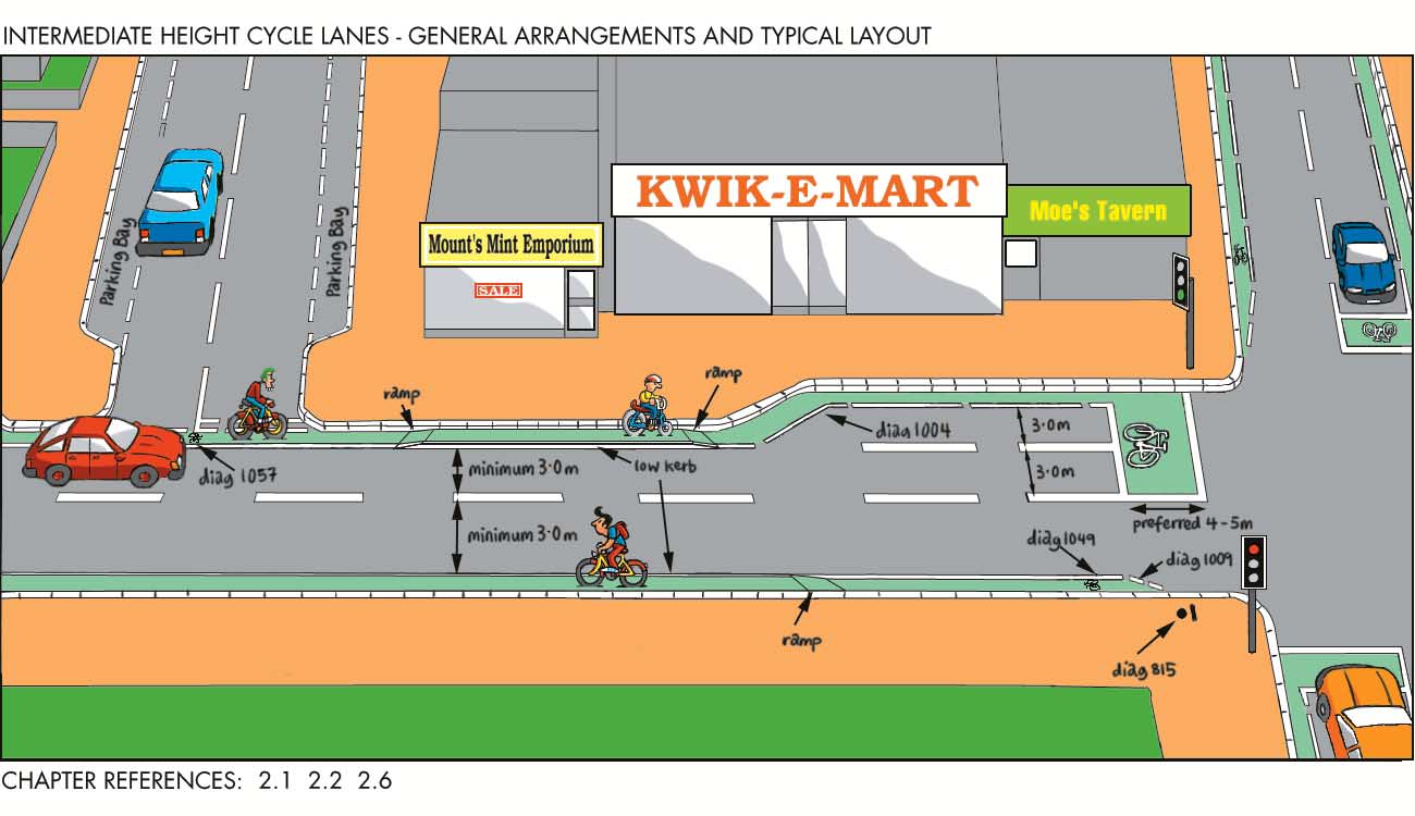
71 2 CYCLE FACILITIES ON LINKS 62


72 CYCLE FACILITIES ON LINKS 2 63
73 2 CYCLE FACILITIES ON LINKS 64

74 CYCLE FACILITIES ON LINKS 2 65


75 2 CYCLE FACILITIES ON LINKS 66
76 CYCLE FACILITIES ON LINKS 2 67
77 Cycle facilities at crossings and junctions Chapter Cycle movements at signal-controlled junctions 3.2 Signal-controlled cycle crossings 3.3 Unsignalled crossings and junctions 3.4 Grade seperated crossings 3.5 Roundabouts and gyratories 3 3
78 CYCLE FACILITIES AT CROSSINGS AND JUNCTIONS 3 Cycle facilities at Crossings and Junctions 3.1 Cycle Movements at Signal-Controlled Junctions General In London all traffic signals are the responsibility of the Traffic Control Signals Unit (TCSU) Casualty data for cyclists show that road crossings and junctions are the most dangerous parts of a cyclist s journey. Complex multi-lane and multi-arm intersections (such as Hammersmith Broadway Gyratory and Vauxhall Cross) are particularly dangerous and often present a significant barrier to cycle movement. Signal control at a junction generally improves cyclists safety and this subsection describes the further measures, including advanced stop lines, that may be introduced at such junctions to help cyclists. The treatment of complex intersections to make them safer and easier for cyclists to use is discussed in below. Essentially the measures that may be introduced will be a combination of those in the following paragraphs preceding , as well as the link measures described in the previous section. The design of signalled crossings is covered in 3.2 and roundabouts and gyratories in 3.5. Above: Cycle exemption at signal controlled crossing Cycle phases as part of signal-controlled junctions are an accepted part of cycle traffic management. Signal staging can also be altered to cater for cyclists. A stage where cyclists have right of way can be introduced (if they have their own lane and signals). Detectors activated by the cycles are used to trigger the cycle phase e.g. London- Strand/Waterloo Bridge in DOT 1986 TAL 2/86. However, cycles without substantial metal mass may not activate the detector, so wherever possible push button controls should be introduced as well, located such that mounted cyclists can operate them Cyclists should be exempt from 'banned turns' - turning movements banned to other vehicles by a traffic Above: Cycle exemption by Contra-flow at signal controlled junction 69
79 CYCLE FACILITIES AT CROSSINGS AND JUNCTIONS 3 order - unless there are insurmountable safety problems. Such exemptions can provide tremendous benefits for cyclists in terms of both convenience and safety. This can be achieved by: special cycle signs or signal facilities; segregated left turn or right turning lanes; jug handled turns; or linking the exemption to exemptions for buses and taxis. At signal-controlled junctions with a left-turn ban to protect pedestrians, for example, cyclists could be exempt by waiting at the junction until the signals change to favour the cross flow. This presumes that there is sufficient space to accommodate waiting cycles and additional signalling Exemptions to signal control can also be provided. For example, cyclists travelling on a main road approaching a signal controlled 'T' junction, with the side road coming in from the right, can be permitted to make an unrestricted straight ahead movement. This movement is made possible by using a cycle bypass lane - a kerb protected lane that has the signals located on the island. The island can extend across the junction or it can lead to a mandatory cycle lane after the signal. Alternatively a short length of cycle track around the signal can be used. Both designs reduce the delay to cyclists travelling along a main road, as well as the incidence of red-light jumping by cyclists, but care needs to be taken of any pedestrian crossing movements. Above: Seperate cycle signals at two-way cycle lane - Cable Street,Tower Hamlets It is intended that any offside approach lane should be used by cyclists, such lanes should be at least 3.5 m wide. If 4.2 m width can be achieved for any right turn approach lanes then consideration should be given to introducing a 1.2 m advisory cycle lane within it Cyclists should normally be allowed to use flyovers and underpasses. However, separate cycle facilities should be provided where flyovers are high or affected by strong cross-winds, or where flyovers or underpasses have narrow lanes. Above: Straight ahead exemption for cyclists - Hyde Park 70
80 CYCLE FACILITIES AT CROSSINGS AND JUNCTIONS Heavy Left Turns by Motor Vehicles Conflicts often occur at junctions with high straight ahead cycle flows and heavy left-turning vehicle flows. Short sections of with-flow cycle lane can be introduced to segregate traffic and separate conflict at junctions. The length of these will largely depend on queue lengths, and the available carriageway space Cycle lane markings: Where traffic volumes are low to moderate and cyclists on the main road wish to make movements straight across a junction, cyclists can be guided to a short length of advisory or mandatory cycle lane (1.0m to 1.5m wide) between the left turn filter lane and the straight ahead lanes for motor vehicles. Cycle symbols [1057], coloured surfaces (recommended) or ghost islands can be used to develop the facilities further. The cycle lane protects cyclists waiting in the lane and helps to guide the cyclist to the nearside lane after the junction. The other vehicles on the main road that are approaching the junction to turn left into a minor road are guided to the nearside lane. Motorists continuing straight ahead along the main road are guided onto the outer lane Physical segregation: Where cycle and motor traffic flows are heavy, a short length of physically segregated cycle lane (about 50m) on the nearside of the carriageway is continued to the stop-line of a signalled junction. The cycle lane is segregated from adjacent vehicle lanes by a long thin traffic island along most of its length, and for the remainder by hatched white lining, or as a semiraised surface. Segregation between straight ahead cyclists and other vehicles wishing to make a left turn is controlled by traffic signal timings. The signal aspects for cycles should have the green and amber lenses masked with a black background to show a cycle symbol [3000.2]. To reduce delay to all vehicles at the junction, other traffic streams may be permitted to move during the green signal for cyclists if there is no conflict between the cyclists and other traffic streams (DOT 1986 TAL 6/86). 71
81 CYCLE FACILITIES AT CROSSINGS AND JUNCTIONS Splitter islands: Cyclists cross from the nearside to the offside lane. They are permitted to go straight ahead into a protected cycle lane within the splitter island. Cyclists can then cross over to a segregated lane possibly leading to some form of contra-flow facility Left Turns for Cyclists At some signalled junctions it may be possible to provide cyclists with a segregated left turn lane. At signalled junctions without pedestrian phases, cyclists can be allowed to make similar left turn movements by the provision of a short segregated cycle bypass around the signals. A 'Give Way' is marked at the exit from the cycle track. These facilities may be difficult to design if space is constrained, and need to be carefully engineered to be safe and well understood, and to avoid creating conflict with pedestrians. Where separate signals are provided for the cyclists it is very important to site the signals carefully so that motorists cannot see the cyclists' aspect. The positioning of secondary signals for the motorist should also be considered to help overcome any possible confusion At physically segregated turning lanes for general traffic the lane width should be wide enough so that cyclists on it are not endangered by turning vehicles and in particular by long articulated vehicles. The width of the lane will depend on the radius of the turn, but should be at least 4 metres on the straight approach section Right Turns for Cyclists Above: Segregated shared surface leading into shared surface at signals G-turn layout - A short 'G'-shaped or 'jug handle' cycle route to ensure cyclists cross over the carriageway directly rather than make a right turn. Splitter island - A short stretch of longitudinal traffic island in the centre of the carriageway, with a cycle lane within the island, protects cyclists from fast vehicles (DOT 1986 TAL 15/86). Two stage right turns - Cyclists at crossroads make the right turn in two stages. The design means cyclists do not have to leave the nearside lane when turning right at a junction with two or more lanes on the approach. This is normally used at crossroads of signalled junctions, but has been linked to Toucan Crossings. Two stage right turns work best if the traffic signals are phased so that the delay to cyclists is reduced. The need for primary and secondary signals and the consequent layout requirements, however, limits its application in the United Kingdom. Right turns from main roads can be particularly hazardous for cyclists as they have to move across traffic following from behind on the approach to the junction. Cyclists do not generally have mirrors and have difficulty in maintaining a straight course when turning to look behind. In addition to the recommendations made in above, concerning the width of approach lanes to signal-controlled junctions, the following facilities to help cyclists make safer right turns should also be considered. Above: Two stage right turn - Ewell Road, Kingston 72
82 CYCLE FACILITIES AT CROSSINGS AND JUNCTIONS 3 Jug handle - At a signalled T junction this would be a short length of cycle track leading from the nearside traffic lane and then swinging round to meet the carriageway at right angles, at a signalled stop line. Cyclists wishing to turn right would cross when signalled, probably in parallel with pedestrians on the same arm of the junction. It should be noted that the jug handle arrangement has other applications, most notably with Toucan crossings (see ). Above: Jug handle at Toucan to provide a right turn - Southend Road, Havering Signal Timings At junctions with wide roads the inter-green periods can also be extended (by up to 3 seconds) to give cyclists more time to clear the junction before the opposing traffic begins to move. Cyclists can also be detected by infra-red/microwave systems that extend the cycle stage in the signal timings On a side road a short green duration can deter unwanted traffic without penalising cyclists who can make it to the front of most queues. Cyclists may need an advanced stop line (see ), a cycle lane or restrictions on waiting and loading to enable unhindered passage to the front of the queue, especially where the existing lane widths are inadequate More details of signal timings, operational cycle, and vehicle detection are listed in DOT (1995) LTN 1/95 & 2/95. Although the titles of these reports refer to pedestrians, much of the material is relevant to cycle crossings. Above: ASL with short ACL lead-in Kensington 73
83 CYCLE FACILITIES AT CROSSINGS AND JUNCTIONS Advanced Stop Lines The advanced stopline (ASL) for cyclists is designed to help cyclists through signalled junctions by enabling them to move off ahead of motor vehicles and clear the junction first. ASLs make cyclists more visible to motorists, and reduce the risk of conflict with motor vehicles by: helping right turning cyclists to position themselves correctly; giving straight ahead cyclists a better chance of avoiding conflict with left-turning motor vehicles, and permitting straight ahead motor vehicles to overtake slower cycles on the far side of the junction, where there is usually a wider lane. Advanced stop lines, as well as improving the safety and convenience of cyclists, may also cause less disruption to other traffic, as fewer cyclists will be interspersed within the queues formed. This may encourage less competitive driving styles to be adopted by motor vehicle drivers (DOT 1996 TAL 4/96). They also enable cyclists to wait away from direct exhaust fumes ASLs should be considered at most signalcontrolled junctions on the LCN (and off the LCN at signalled junctions that have high cycle flows). They are particularly valuable at junctions where cyclists are in conflict with other vehicles making right or left turns, and if there are many HGVs among the other vehicles. If traffic is only allowed to make the straight ahead manoeuvre, the ASL are of less value, but are still useful however, as they allow cycles to jump queues of traffic Two main layouts of traffic signal arrangements and signing layouts, have been used. 'Simplified' Layout (now universal) The recommended layout for LCN routes has a single primary traffic signal at the cyclists' stop line. The design uses conventional signals at the cyclists' stop line and should have advisory or mandatory lead in lanes. An advisory lane works reasonably well, but may suffer from encroachment. When a cycle lane is blocked, the advantage of the reservoir for cyclists is partly lost. The design is cheaper to install and easier to adjust than the double signal layout, should this be required. It can be applied to existing signals without any alteration to the actual signal, because the lining change is actually to introduce a retarded vehicle stop line. If loop detectors are used then these will need to be relocated or replaced with the infra-red type. Double Signal Layout (now superseded) The double signal layout had signals at both stop lines, mandatory cycle lanes and comprehensive signing. The signals at both stop lines operate concurrently. The first signal, at the motorists' stop line, has an additional green cycle symbol of recommended diameter 200mm. The symbol is illuminated only when the signals at both stop-lines show red and allows cyclists into the reserved area. The ASL signal is equipped with 'red light monitoring' to ensure the green cycle symbol on the first signal goes out if the red light at the ASL signal fails. Overall, ASLs with a single traffic signal are as effective as those with two signals, if a mandatory cycle lane is used and visual emphasis given to the reservoir ASLs have a reserved area or 'reservoir' between two stop lines - a stop line for motorists and a stop line for cyclists. This reservoir is usually 4.0m to 5.0m long. 4.0m is recommended for LCN routes, though the length of the reservoir should be extended if there are high flows of cyclists. If the reservoir is less than 4.0m cyclists might feel intimidated by the close proximity of the vehicles queuing behind them, and also right turning cyclists may not be able to position themselves properly after using a nearside ACL approach. If the reservoir is more than 5.0m, motorists are more likely to encroach into it. The reservoir incorporates a cycle symbol to [1057] painted on the road, to remind road users of its purpose and to discourage encroachment by motor vehicles. The design also allows a motorists' stop line width of 300mm, and a cyclists' stop line width of 200mm, which increases motorists awareness of the purpose of the reservoir. Partial reservoirs, not covering the full width of all the approach lanes (if there is 74
84 CYCLE FACILITIES AT CROSSINGS AND JUNCTIONS 3 more than one approach lane), or staggered stop lines may be useful where cyclists do not need to turn right and where that area could be overun by other turning vehicles To help cyclists bypass traffic queues and reach the waiting area a length of cycle lane is used on the approach to the junction. The lane is usually 1.0m to 1.5m wide (recommended) for mandatory lanes, and 1.2m recommended, with 0.7m the minimum for advisory lanes. These Mandatory lanes must be indicated by signs [958.1 and 959.1] (backed by a TRO prohibiting motor vehicles from the lane). Advisory lanes should be signed [967]. The length of the cycle lane on the approach will vary according to the particular circumstances of individual sites, such as parking restrictions, but should preferably be as long as possible, either to the end of the longest queue of traffic when the signal is red, or for a continuous length to the previous junction Experimental ASLs without cycle lane on approaches have been introduced in London. These either have very short lanes or a broken motorists' stop line 1.2m from the kerb, and a cycle symbol just before the stop line. A reservoir with an approach cycle lane for ASLs is recommended for LCN routes, though the layout without an approach lane may be preferred to not having an advanced stop line at all. Where the carriageway width is limited and the footway is wide enough, it may be possible to widen the carriageway or install a short length of cycle track on a converted footway. Above: ASL on a round topped speed hump - Earlsfield Above: Advanced Stop Line where cyclists do not need to turn right - Gayton Road, Harrow The approach cycle lane is normally located on the nearside. Alternatively the lane can be located centrally (i.e. between the left turn and straight ahead all-vehicle lanes) or on the offside. The choice of location depends on the signal timing and the main cycle and motor vehicle movements through the junction (DOT 1993 TAL 8/93). For example, right turning cyclists may prefer to position early for the manoeuvre and approach in the centre of the carriageway, i.e. the offside. Above: Central ACL to ASL - Camden 75
85 CYCLE FACILITIES AT CROSSINGS AND JUNCTIONS 3 Where a junction is characterised by left turning motor vehicles and cyclists travelling straight ahead, there is value in siting the approach cycle lane away from the nearside of the carriageway, e.g. between two lanes. This encourages cyclists to position themselves to the offside of left turning vehicles before the junction. This can be especially useful where the all-vehicle nearside lane has been marked for left turns only. Cyclists in these locations have few problems in reaching the central cycle lane. Consideration should be given to starting the cycle lane before the start of the left turn lane, so that motorists turning left have to cross the advisory cycle lane. Normally, central cycle lanes are advisory as it is difficult to enforce mandatory lanes in this position. Motor vehicles may need to encroach into the cycle lane to position correctly at the junction, which would not be possible if the lane were a mandatory one. Although the level of encroachment by motor vehicles on a cycle lane situated centrally is higher, the risk of conflict between cyclists going ahead and high left turning flows of motor vehicles may be reduced Cyclists gain full advantage from an ASL when the 'red' traffic signal aspect is displayed at the junction, as they have time to position themselves in the reservoir area, ready to move off ahead of motor vehicles. If the proportion of red time in a traffic signal phase is small, and if the signals change frequently, use of nearside cycle lanes may present cyclists with difficulties when making a right turn. This is because they have less opportunity to make use of the reservoir area to move to the centre of the carriageway, ready to make their manoeuvre. There is also a possibility of the signals changing from red to green as the cyclists approach the junction, when cyclists who had planned to use the reservoir area to position themselves for the manoeuvre will no longer be able to do so Right turning cyclists are more likely to remain in a nearside approach cycle lane where motor vehicle flows are low. However, sometimes, right turning cyclists take the earliest opportunity to position themselves on the right hand side in anticipation of their manoeuvre. A threshold of motor vehicles per lane per hour exists, after which cyclists supposedly start to abandon use of a nearside lane (DOT 1996 TAL 5/96). It would of course be possible to have two cycle lanes, nearside and central or nearside and offside etc., feeding into an ASL reservoir. Above: Right hand cycle lanes leading into ASL, can be used - Camden Cycle approach lanes have also been used on the right side of roads where the right turn is for cyclists only, or when cyclists may emerge from a side road on the right. Above: Advance stop line with side entry - Eden Street, Kingston 76
86 CYCLE FACILITIES AT CROSSINGS AND JUNCTIONS A coloured surface on the reservoir and approach lane makes it more visible and reduces encroachment by motor vehicles An ASL may cause a junction to lose capacity in theory of because the reduced lane widths, the motorists' stop line is further back and cyclists move off in front of the motorists. This can add to starting 'lost' time for motor vehicles, thus shortening the effective green time. On the other hand, capacity may be increased because the subsequent saturation flows for left turn and straight on traffic may be higher, since they are less hindered by cyclists. The number of cyclists able to get through each green time may also be increased as they can get to the front of the queue during the red time. Measurements at a site in York showed a slight increase in motor vehicle saturation flow (DOT 1993 TAL 8/93). Subsequent experience shows that ASLs seldom affect signal capacity but may require slight re-timing of the signals intergreen periods Complex Intersections Complex intersections are particularly dangerous for cyclists and often pedestrians as well, and frequently present a significant barrier to cycle movement. It has previously been noted that the measures that may be introduced to improve conditions for cyclists will be a combination of the various link and junction facilities described above. An essential starting point for any study of the intersection is a clear idea of where the direct cyclist (and probably pedestrian) desire lines lie It is probably fair to say that the greatest likelihood of achieving the best possible facilities for cyclists (possibly making use of opportunities such as open space) occur when the operation of the entire complex intersection is reviewed, and the needs of all its users (buses, cyclists, motor vehicles, pedestrians) considered comprehensively. This is most likely to occur if such an approach is easily accommodated within a borough council s transport and land use planning, and traffic management procedures. Above: Parallel cycle pedestrian crossing at a complex intersection - Harrow Above: Use of elephants feet can help cyclists at complex junctions - Shepherds Bush 77
87 CYCLE FACILITIES AT CROSSINGS AND JUNCTIONS Opportunities to review a complex intersection may arise from: - A new road proposal. In London this is extremely rare; the new traffic circulation around Kingston town centre was implemented in 1989 and fairly comprehensive cycle facilities were introduced at the same time (see chapter 3). In the years following, further improvements to provide continuous cycle routes across and around the Town Centre area have been, and are continuing to be made. - A project to improve a particular area. This occurred, for example, some years ago in Shepherd s Bush, with a scheme to improve the appearance of, and access to, the Common (see chapter 3). Footpaths were re-located away from the carriageway edge, with landscaping, a new cycle track on the common effectively by-passing the one-way system (which was also modified to introduce wider traffic lanes which are safer for cyclists to use) and new cycle and improved pedestrian crossings to and from the Common. The scheme has been fully implemented. - Priority (Red) Route Local Plan development. The Plan process has resulted in a number of proposals to improve complex intersections, and the opportunity has been taken to improve cycle facilities at a number of them. At the Chelsea Bridge Road, Chelsea Embankment junction, for example, comprehensive cycle facilities have been included in the scheme proposed for implementation in In future reviews of the Priority (Red) Route Network, opportunities to add to the provision for cyclists should be considered. - Development proposals. Large development proposals often result in the need, or opportunity, to review the surrounding road system. For example, a study is currently underway into the possibilities for unscrambling the oneway system around South Kensington Underground Station, for which there are redevelopment proposals. This would introduce a traffic management scheme which releases more pavement space and more protection for cycle movement. A further example is the redevelopment of Hammersmith Broadway. This was accompanied by the introduction of signalled ground-level pedestrian crossings which, whilst not physically protecting cyclists, at least introduces more discipline to traffic movement and gives cyclists the opportunity of dismounting and using pedestrian facilities to pass through the area (previously only subways were available). 78
88 CYCLE FACILITIES AT CROSSINGS AND JUNCTIONS Signal Controlled Cycle Crossings General In 3.1 cycle movement at signal-controlled junctions was considered, and the ability to alter signal staging to cater for cyclists was recognised. This can allow cycle crossing movements to be signalled between the road and, for example, a cycle track coming into the junction from an adjoining park Further types of signal controlled cycle crossings are: - exclusive signal-controlled cycle crossings; - parallel cycle and pedestrian crossings; - Toucan crossings. Above: Parallel crosssing leading to junction island - Eden Street, Kingston These are described in more detail below Exclusive Signal-Controlled Cycle Crossing This is a special measure to help cyclists cross busy main roads. The signals are usually activated by cyclists passing over a detector buried in the cycle lane. The signal aspects operate in the same way as conventional traffic signals, but green and amber cycle symbols [3000.2] replace the usual plain green and amber lights [3000]. The cyclist s green time need only be short - less than that for pedestrians. It should be followed by a sufficiently long inter-green phase to allow all permitted movements to be completed safely At signal-controlled cycle crossings with the cycle track or lane approach used exclusively by cyclists, two inductive loops are usually employed to detect cyclists and to prevent a false call (the first at 12m before the stop line and the second 4m before the stop line). Both loops should call and extend the stage. The loops should be sited where the cyclists will pass over them, particularly near the kerb. The extension times should normally be 2 seconds for the 2-loop configuration, but can be altered to suit site conditions (DOT 1986 LTN 1/86). Some non-metallic or aluminium bikes may not be detected by these loops, and therefore push buttons for cyclists should also be provided wherever possible. 79
89 CYCLE FACILITIES AT CROSSINGS AND JUNCTIONS Parallel Cycle and Pedestrian Crossing A parallel crossing is really two crossings - a parallel and separate route for each mode, with its own set of lights (DOT 1987 TAL 6/87). Cyclists' and pedestrians' green phases run concurrently. This arrangement of concurrent phases means that cyclists are prohibited from turning in the direction of the pedestrians' part of the crossing. Where there is a choice, the cycle crossing should be located on the side of the pedestrian crossing that minimises the prohibited cycle turning movement and potential conflicts with pedestrians Parallel crossings can be linked to staggered central reservation crossings with guard-railing 'pens' to separate cyclists from pedestrians (see DOT 1986 TAL 13/86).They are particularly useful where there are high flows of pedestrians and cyclists and where these movements may cross. Deficiencies with parallel crossings include delays to cyclists, as they have to wait to receive the 'green cycle symbol', and use by pedestrians of whichever side of the crossing suits them. The crossing is relatively expensive to install, because of the amount of signal equipment used and the space it occupies, and is considered excessively cluttered with many signal heads - normally at least 10 of them. However, this design does have more flexibility on signal timings than toucans The pedestrian crossing has 'Red Man'/'Green Man' signals [4002] and has standard 3-aspect signals to control road traffic. The signals controlling cyclists should also be 3-aspect (normally 210mm diameter) but with green and amber cycle symbols on a black background instead of the full green and amber lenses [3000.2] (DOT 1986 LTN 1/86). The signals respond to a demand from buried loops or microwave vehicle detector or pedestrian type push button The cycle crossing can be between 1.0m and 5.0m, from the pedestrian crossing to help segregate pedestrians and cyclists (DOT 1986 LTN 1/86). However, separation should not be so large that motor vehicles come to a halt between, or on the crossings, and the minimum separation is therefore preferable. The path of the cycle crossing is marked on the carriageway by white squares 400x400 with 400 gap [WBM 294] for which special GOL (DETR) authorisation is presently required Where the pedestrian and cycle crossing routes are combined into unsegregated use on leaving the parallel crossing, cyclists should be required to give-way to pedestrians using 'Give Way' markings [1003] supplemented by markings [1023] - where this is thought necessary (DOT 1986 LTN 1/86). If cyclists share the use of an adjacent converted footway with pedestrians then it is normally appropriate that they share the crossing, so provide a Toucan, it s cheaper too. Above: Parallel cycling & pedestrian crossing 80
90 CYCLE FACILITIES AT CROSSINGS AND JUNCTIONS Toucan Crossing The Toucan is a signal-controlled road crossing where cyclists and pedestrians cross the road at the same time, sharing the same space. As a result the Toucan is less expensive and less visually intrusive than the Parallel Cycle Crossing and, because cyclists and pedestrians cross in the same space and at the same time, there is no need to prohibit cyclists from making turns (except where other general traffic restrictions apply, such as one-way flow). The signals are activated by a push button. Inductance loops can be used to detect cyclists, although these should always be supplemented by push buttons for both pedestrians and cyclists. Push buttons should be located next to each corner of the crossing so it is convenient to push in whatever direction a pedestrian or cyclist approaches the crossing. Above: A very green Toucan - Trinity Road,Wandsworth Cyclists and pedestrians are controlled by three signal aspects: a 'Red Man', then a 'Green Man' [4002] and a simultaneous 'Green Cycle'. The 'Red Man' is a warning to both cyclists and pedestrians that the main road traffic has priority and that it may be unsafe to cross, and is illegal for cyclists to cross (Morgan 1993). The 'Green Cycle'/'Green Man' signals are an invitation to cross with care, where appropriate. A black-out period follows the green signal so as not to encourage further crossing movements Vehicular traffic approaching a Toucan crossing is controlled by the normal three aspect signal as used at junctions. (Because cyclists can clear the crossing relatively quickly, motorists can often be required to stop when there is nobody using the crossing). This delay could lead to 'red running' though this would depend on the traffic flow. The use of on-crossing (infrared) detection over the carriageway area can help reduce the delay to vehicle drivers and also enables the 'black-out' period to be extended to allow a 81
91 CYCLE FACILITIES AT CROSSINGS AND JUNCTIONS 3 longer crossing period. Details of signal timings, operational cycle, and vehicle detection for Toucans are listed in DOT (1995) LTN 1/95 & 2/95. It is likely that in the longer term 'far-side' signals will be replaced by 'nearside' signals similar to those used at Puffin Crossings. However, at the present time suitable equipment is not available, though it is expected to be available by An unsegregated area at the footway threshold is the preferred DETR design (see DOT 1993 TAL 10/93). Segregated approaches, however, have also been used but unless either a level difference or a raised white line is used to separate cyclists from pedestrians, this is not recommended. Tactile surfaces are needed across the full width of the approach for unsegregated approaches and only across the footway approach for segregated approaches. Cyclists wishing to use a Toucan crossing, and approaching it on the carriageway, can be provided with a jug handle facility or segregated surface for the final approach to the crossing White zig-zag lines are to be prescribed by DETR in the TRSGD 1998 to control parking and overtaking at the approaches to the Toucan. At present zig-zags are only allowed at Toucans if the support of local police is obtained, in London the Metropolitan Police will not agree to this. If parking restrictions are needed then yellow line markings are necessary, these restrictions require traffic regulation orders if they are not already in force All layouts require the following: Red blister tactile surfaces, Audible bleepers and/or tactile rotating knobs, Push buttons in each corner of the crossing, Red lamp monitoring, Vehicle detection on all approaches. Crossing width should be 4.0m desirable. A minimum of 3.0m could be acceptable in some situations (DOT 1993 TAL 10/93). Greater widths will be required on more heavily used crossings Signal crossings that have been converted to Toucans include Zebra crossings, Pelican crossings, exclusive cycle crossings and parallel crossings (see Morgan 1993 for an analysis of Toucans, Puffins and pedestrian signals at junctions) Installation and operation of the crossing should be publicised, particularly to nearby schools and local associations for blind people. The DETR recommends local authorities carry out safety audits where Toucan crossings are proposed (DOT 1993 TAL 10/93) GOL via TCSU sign authorisation is required for the cycle signal aspect on the modified [4002] and the modified push button plate [4003], although these will be prescribed in the new TSRGD The Toucan is particularly useful near 'T' junctions if connected by a cycle track from the side road. It is also a useful link between minor roads that have been closed (but with exemptions for cyclists) either side of a main road. 82
92 CYCLE FACILITIES AT CROSSINGS AND JUNCTIONS Unsignalled Crossings and Junctions General Signals are not always the most appropriate measure to help cyclists cross roads, particularly less heavily trafficked ones, as they can cause cyclists unnecessary delay where there are gaps in the traffic. To help cyclists cross such roads without signals, several measures are possible, some of which may be converted at a later date to include signals Some of the measures proposed below help cyclists by allowing them to cross a road in two stages. It is also possible to guide cyclists across a cycle route crossing of a road by means of road markings and signs such as [950]. Advisory cycle crossing markings [WBM 294] - 400mm white square elephants footprints markings - help cyclists across junctions with low flows and traffic speeds. Note these markings do not appear in the Traffic Signs Regulations and General Directions 1994 and therefore require authorisation from GOL (DETR). This marking can be hazardous, particularly if used on main roads, as they can give the impression to motorists that they have to Give Way. Cyclists may interpret this as according them priority, where in fact no priority exists, so either stop lines or 'Give- Way' markings and logos should be used on the cycle approaches. Traffic calming measures to slow traffic should be considered. Above: Unsignalled cycle crossing - King Street, Hammersmith Give Way markings can be painted on the approach of a cycle track to a road crossing. Where there is two-way movement of cyclists on the cycle route, separation of each movement should be made by a white line [1004] on each approach to the crossing. Arrow [1059] and cycle symbol [1057] markings can help cyclists to use the correct part of the cycle route. The Cycle Route Ahead sign [950] should be used to warn drivers of the crossing. Keep Clear [1026] markings may help to deter vehicles obstructing the cycle crossing by, say, vehicles tailing back as they wait to enter a junction further on from the crossing. If necessary, signs [963.1 or 955] warns pedestrians of a cycle lane or track. This crossing is best suited to roads with low vehicle flows and speeds. 83
93 CYCLE FACILITIES AT CROSSINGS AND JUNCTIONS Priority Junctions Cyclists crossing a main road between two minor roads can do so in two stages if a turning lane is marked out for motor vehicles turning right off the main road. Such lanes should preferably be 2.5 m wide (1.5m minimum) and also act as a useful refuge for cyclists turning right off the main road into the side roads Footway buildouts at junctions along the cycle route can reduce traffic speeds on main roads and make it easier for cyclists to cross. The build-outs can also discourage parking at junctions, making it easier for pedestrians to cross. Care must be taken to preserve good drainage and avoid pinch points where cyclists are squeezed with motor vehicles. Alternatively parking could be restricted for short distances (20m) from the junction, with hatched markings used to emphasise the restriction. The swept paths for appropriate vehicles need to be checked if build-outs are planned and care should be taken to ensure manoeuvring by cyclists is not made more difficult, particularly if there are many buses and HGVs on the main road. If this is the case, hatched markings can provide an alternative For cyclists wishing to turn right off a main road on which a right turning lane cannot be marked out, it may be helpful to introduce a jug handle section of cycle track leading off the carriageway to provide them with somewhere to wait before crossing the road When an on road cycle route crosses a similar road, a change of priority should be considered to make the cycle route the major road. Priority should not be removed from a road that carries in the region of 100 vehicles per hour more than the minor road (DOT 1989 LTN 1/89). Above: Kerb build out at junctions, with ACL - Burntwood Lane, Wandsworth Build-outs can be considered on minor roads if the carriageway is more than 6.0m in a two-way street or more than 3.5m in a one-way street. On the major road build-outs can be considered if the carriageway is more than 3.5m for vehicles travelling in one direction (the 3.5m minimum allows 2.8m for motor vehicles and 0.7m for cyclists) though 4.0m is recommended if there is no intention to reduce the speed of traffic on the main road. 84
94 CYCLE FACILITIES AT CROSSINGS AND JUNCTIONS Priority Cycle Crossings For cycle tracks along main roads cyclists can be given priority over turning traffic by introducing 'Give Way' markings and associated calming measures for vehicles crossing the cycle route; otherwise cyclists may feel it is more convenient to stay on the carriageway. Where possible this priority for cyclists should be self-enforcing, by making motor vehicles drive slowly at the cycle crossing. The motor vehicles can be controlled by: Road narrowing; Above: Give way markings on approach to road crossing Road humps on the approach to the crossing; Different coloured and textured surfacing. Speed tables/flat top kerb-to-kerb road humps, which slightly raise the level of the crossing. The maximum permitted height of a road hump is 100mm, with 75 recommended by DETR as the norm. As kerbs are generally 125mm to 150mm (DOT 1996 TAL 7/96), a level crossing may need the kerb line to be dropped. The same applies to Toucan crossings. If the cycle track runs parallel to the major road carriageway, priority crossing of minor roads (and some work entrances and private drives) should be combined with a 'bending out' of the cycle track if possible (see the Cycle Track section for more details). Otherwise, cyclists should continue to 'Give way' at the crossing Cycle track priority road crossings should only be used for crossing single carriageway roads where the vehicle flow is less than 4000 vehicles a day and speeds are less than 30mph. Pedestrians are not accorded the same priority as cyclists in such a layout. Sign [950] advises motorists and sign [963.1] advises pedestrians of the cycle track. 85
95 CYCLE FACILITIES AT CROSSINGS AND JUNCTIONS Protected Two-Stage Crossings Refuge (island) crossing - The provision of a widened centre refuge (island) to allow cyclists on a cycle track to cross a wide carriageway in two stages. Advisory cycle crossing markings [WBM 294] may be used with this design if speeds on the road are less than 30mph or cyclists are protected by signals, though authorisation is needed from GOL (DETR). Islands can significantly reduce delay for cyclists and diminish errors of judgement on the second half of the crossing. They also help to slow motor traffic on the road. The minimum central refuge width for safe use by those with wheelchairs, prams and cycles is 1.8m, preferably 2.0m. The longitudinal width should be from 3.0m to 5.0m (absolute minimum of 2.5m if there is no lamp column). The route through the island should be flush with the adjacent carriageway. The width of the carriageway on the main road should conform to the standards set out in the section on traffic calming (road narrowing) Central reservation crossing - On a dual carriageway it may be possible to widen or provide a staggered cycle route through the central reservation, so that cyclists can cross the carriageway in two stages. Guard-railing may be needed to protect and guide cyclists through staggered crossings (2.0m minimum distance between guard-railing - Sustrans 1997). The width of approach and entry into the refuge should not be less than 2.5m for two-way cycle traffic (DOT 1986 LTN 1/86). The entrance into the staggered refuge should be such that cyclists ideally turn left within it and are facing oncoming traffic when arriving at the exit. The central reservation should be at least 3.0m wide (Sustrans 1997) kerb-to-kerb in order for two-way staggered crossing to provide sufficient waiting and passing room for cyclists within the guard-railed pen. Speed reduction measures or signals should be considered at these crossings 'Sheep pen' refuge crossing - This design helps cyclists cross a main road at a staggered cycle track. Specially constructed islands are built in the centre of the carriageway and linked by a narrow kerb and guard railing. The design channels cyclists to the best crossing locations for maximum visibility. A similar design uses kerb build-outs and long thin islands on the kerb side to protect cyclists Hatch Markings - (Ghost Islands) In some situations simple hatch markings can give a level of protection to cyclists if there is inadequate space to provide traffic islands Slip Road Crossings Cyclists who use main roads face considerable risks where slip roads leave or join the main road at grade-separated junctions. Slip road design permits other vehicles to join or leave the main road at high speed. Cyclists going ahead on the main road are therefore in danger for the considerable time taken to cross the slip road. The difficulties are worse where the main road is climbing. To help cyclists cross the slip road traffic a short crossing can be introduced over the slip road. Cyclists are directed off the main carriageway onto a short stretch of cycle track with a small 'Give Way' marking on one side of the slip road. They then cross the slip road at right angles and proceed along the slip road or a cycle lane or separate cycle track parallel to the slip road. Although these crossings may reduce the risk of accidents, they can impose some small inconvenience and delay to cyclists A similar 'mirror image' scheme is possible on exit slip roads by which the cyclists leave the main carriageway along the slip road and cross it at right angles to return to the main carriageway (DOT 1986 LTN 1/86) Special signs warn cyclists of the danger ahead, and other road users that cyclists are crossing. The crossings require advance direction sign [WBM 336] erected 200m from the crossing point where there is a hard strip, and 85m when there is not. Motorists on the slip road are warned by 'cycle route ahead' sign [950]. This is erected 250m from the crossing point on the offside of the carriageway and 200m on the nearside (DOT 1988 TAL 1/88). Road markings [WBM 294] show the route across the carriageway for cyclists. 86
96 CYCLE FACILITIES AT CROSSINGS AND JUNCTIONS Grade Separated Cycle Crossings General The safest way for cyclists to cross a busy road is by grade separation using subways or bridges. The advantage is lost, however, if the crossing is inconvenient to use or gives concern for personal security issues, and as a result is ignored by cyclists. When maintaining, improving and strengthening schemes for individual subways and bridges occur, it is essential that the needs of cyclists are taken into account by providing better facilities Pedestrian subways and footbridges generally have the status of footways upon which cycling is an offence under the 1835 Highways Act. This is often reinforced by a traffic regulation order to support 'pedal cycling prohibited' signs [951]. The procedure for converting pedestrian subways or footbridges to shared use is the same as that used for a footpath or footway (see 2.6) Where steps lead to bridges or subways, part of the width of each step, (0.3m) can be filled in to provide a wheeling ramp for dismounted cyclists. Alternatively a raised steel channel may be used (76mm wide by 38mm deep) located close to the side wall of the ramps (DOT 1986 LTN 1/86). Steel channels should have anti-skid surfacing so that the cycle tyres do not slip on polished steel. This problem is accentuated in wet weather as the brakes have to be applied while the cycle is being wheeled down the channel. While it is possible to erect a sign recommending that the channel is not used for downward movement, this is less than satisfactory. Pedestrians must not be unduly inconvenienced by these measures, e.g. people who are elderly need access to hand rails, so these should not be affected by the ramps. It should be recognised that cyclists usually wheel their cycles to their right and can find it awkward to do the opposite, especially on steep ramps, so ramps both sides are desirable. 87
97 CYCLE FACILITIES AT CROSSINGS AND JUNCTIONS Short lengths of cycle track are normally needed between the bridge or subway and the road. Drop-kerbs should be used on approaches to or from the carriageway to the cycle track leading to the bridge or subway. Shared facilities should be clearly signed and marked (e.g. coloured or textured surface and tactile paving should be considered) for pedestrians who may be blind or partially sighted or elderly (for more details see 2.7 and DOT 1990 TAL 4/90) Bridges Bridges can be built or converted wholly for use by cyclists or for shared use with pedestrians. When shared with pedestrians, bridges can be segregated (by ramps, speed restricting barriers, textured surfacing, paint markings) or unsegregated. Segregation, in the form of a barrier or change in level, is needed where high cycling speeds are possible (e.g. Cambridge Cycle/Pedestrian Bridge DOT 1989 TAL 9/89 and Wilford Bridge Nottingham - DOT 1986 TAL 14/86) The height of the bridge parapet should be raised to a minimum of 1.4m (DOT 1986 LTN 1/86) Bridges over carriageways require a clear headroom of 5.1m, so the difference in surface levels may be 5.5m or more. Where the road lies in cutting, the bridge level may not be much different from the surrounding land, but when the approach ramps need to rise by as much as 5.5m these ramps will need to be long if their gradient is not to deter cyclists. Gradients of 1 in 20 (5%) are preferred to 1 in 13 (8%), but 1 in 13 may be necessary to reduce the length of the ramp. In most respects the design of shared footbridges and their approaches follows guidance given for subways Existing Subways Existing pedestrian subways can also be converted to shared use by pedestrians and cyclists if headroom is at least 2.4 metres (see DOT 1987 TAL 7/87 and DOT 1986 TAL 11/86). The way through the subway is converted from a footpath or footway to a cycle track, normally retaining right of way on foot (IHT 1983). Above: Cycle channel that has seen better days If flows of both modes are very low, it may be possible for cyclists and pedestrians to share the footway without segregation. If flows of both modes are high, some form of segregation will be required to reduce the possibility of conflict and reduce the speed of cyclists travelling down the ramps. This may be achieved by providing separate parallel paths for cyclists and pedestrians through the subway and by erecting central steel barriers, or double or 'staggered' steel barriers, at potential conflict points (usually where the down ramp meets the barrel of the subway). It is important to ensure that the barriers are not themselves safety risks The staggered barrier is a design in which a tubular barrier straddles the cycle track and another straddles the footway, with a 2.0m minimum spacing between the two barriers to allow for tandems, tricycles and electric wheelchairs to pass. Another design separates pedestrians and cyclists by a central barrier and uses a 'spur' barrier to slow cyclists. Gaps in barriers should be 88
98 CYCLE FACILITIES AT CROSSINGS AND JUNCTIONS 3 wide enough for cycles, wheelchairs, prams and double buggies, 1.0m is preferable, minimum 0.8m gap needed with a straight approach (DOT 1986 LTN 1/86). Alternatively approaches to the subway can be realigned to remove the need for staggered barriers and improve visibility. Generally the approach and alignment through a subway should give as much visibility and natural light as possible. Textured surfaces and brightly painted tubular handrails warn blind or partially sighted people of the shared use The widths of the footway and cycle track depend on the layout of the site, but generally conform to shared use dimensions. Signs should indicate the cycle route through the subway, warn pedestrians and cyclists that the subway has been converted, and show which path is for cyclists and which is for pedestrians With segregated two-way flow, both cyclists and pedestrians need a minimum path width of about 1.5m to pass each other. Thus subways much less that 3.0m wide will be generally unsuitable for segregated cyclist and pedestrian use, unless the flows of one or both modes are low. The presence of a wall or longitudinal barrier (such as between the pedestrian and cycle areas) increases the width requirement for cyclists by 0.5m. The figure of 3.0m above includes an allowance for the effect of walls (without handrails on the cyclists' side) but not of a divider barrier If the flows of pedestrians through a 3.0m wide subway are high, then a 1.5m path allocated to pedestrians may give the appearance of being particularly restrictive and encourage pedestrians to encroach onto the cycle track - especially if the pedestrians walk in groups to push trolleys or prams. However an increase in the width of the pedestrian path would reduce the width of the cycle track to below the minimum for safe passing, so that cyclists passing each other would have to encroach onto the pedestrian path. In such situations unsegregated shared use is recommended, subject to there being visibility enhancing and speed reducing measures - such as convex mirrors and barriers - at the barrel entry. Above: Cycle path through subway Above: Bridge over cycle path - North Kensington 89
99 CYCLE FACILITIES AT CROSSINGS AND JUNCTIONS Good lighting, sight lines and drainage, as well as regular cleaning, are required if a subway is to be safe and attractive to use. It is unlikely that cyclists will use the subway unless there are ramps giving access to the tunnel from the road. To limit the effort needed to cycle up the ramp and discourage down cyclists from high speeds, the gradient of any access ramp should preferably be shallower than 3% and not exceed 5%. If space is very restricted a gradient of up to 7% may be adopted New Subways DOT (1995) advice on stopping sight distances for cyclists, and the layout, dimensions and construction of new subways for pedestrians and pedal cyclists, (and equestrian use) is given in Volume 6 'Road Geometry' of the Design Manual for Road and Bridges (DMRB). It is summarised below for segregated and unsegregated shared use respectively Segregated shared use: the minimum recommended footpath width is 2.0m, the minimum cycle track width is 2.5m and the margin between the subway wall and cycle track 0.5m. If the length of the subway is less than 23m a headroom of 2.4m for the cycle track and 2.3 for the footpath is recommended. A headroom of 2.7m for the cycle track and 2.6m for footpath is recommended for subways with a length of 23m or more. These dimensions are summarised in the table below: The sight line of a cyclist should be taken from a point 1.5m high, and at least 0.6m away from the edge of the cycle track Unsegregated shared use: the minimum width of the subway is 4.0m, (reduced to 3.0m if space is restricted or the number of pedestrians and cyclists is very small). If the length of the subway is less than 23m a headroom of 2.4m is recommended. A headroom of 2.7m is recommended for subways of a length of 23m or more. Table a Minimum Dimensions for New Segregated Shared Use Subways Subway Length (m) Height (m) Width (m) Cycle Track Footpath Margin between subway wall & cycle track Cycle Footpath Below 23m 23m & above Source: DoT (1995) DMRB Table b Stopping Sight Distances & Radius of Curvature for cyclists in Subways Design Speed (km/h) Min Stopping Sight Distance (m) Min Radius of Curvature of Walls Adjacent to Cycle Track (m) Min Radius of Curvature of Walls Adjacent to Footpath (m) 10 & below 25 & below Source: DoT (1995) DMRB 90
100 CYCLE FACILITIES AT CROSSINGS AND JUNCTIONS Roundabouts and Gyratories General Compared with signal-controlled junctions, roundabouts offer greater traffic capacity and smoother flow, and can sometimes be safer in overall terms as well. However, roundabouts can pose particular problems for cyclists, especially those with four or more approach arms and more than one entry lane and circulatory lanes. The TAL 9/97 'Cyclists at Roundabouts - Continental Design Geometry' gives some additional guidance on roundabout design Three types of at-grade roundabouts are - Signalled roundabouts. An increasing number of the larger roundabouts in London are being converted to signal control, either on the approach arms to the roundabouts, the circulatory carriageway, or both Safety at Roundabouts Cyclists are particularly at risk at conventional roundabouts where they are over 14 times more likely to be involved in an accident than a motorised vehicle (DOT & IHT 1987). Conventional roundabouts with large flared entries and smaller central islands are more dangerous for cyclists than similar roundabouts with larger central islands (20m to 70m diameters) and parallel entries (DOT 1995 DMRB v6). considered in this sub-section: - Mini roundabouts. These have a one-way circulatory carriageway, flush or slightly raised central markings of less than 4 metre diameter with or without flared approaches. They have been used in a large variety of situations and distinction is made between their application as a traffic calming device in residential Table Guideline for Shared Use at Subway and Bridges areas (see also section 5) and their use on main roads. Width of ramp and barrel Type of Segregation - Conventional roundabouts. These have a one-way circulatory carriageway, a kerbed central island of at least 4 metres diameter, usually with flared approaches (to allow multiple vehicle entry). The number of entry lanes varies from one upwards but rarely exceeds four per arm. Below 2.7m m Above Unsegregated Segregated by white line Segregated by continuous kerb, change in level or longitudinal barrier Table Minimum Dimensions for New Segregated Shared Use Subways Subway Length (m) Height (m) Width (m) Cycle Track Footpath Margin between subway wall & cycle track Cycle Footpath Below 23m m & above Source: DoT (1995) DMRB 91
101 CYCLE FACILITIES AT CROSSINGS AND JUNCTIONS 3 The greater the number of arms on a roundabout the greater is the accident problem, particularly for cyclists. Five arm roundabouts should therefore be avoided or separate cycle provision made. Accidents typically involve circulating cyclists being struck by entering vehicles, or vehicles exiting from the roundabout and cutting across the paths of cyclists continuing through the junction. The largest roundabouts (or gyratories) are most feared and often avoided by cyclists. Though the accident rate on such intersections is unclear, accident statistics for the proposed Priority 'Red' Route Network in London show that large roundabouts and gyratories in London are major cycle accident black-spots Mini roundabouts on main roads are much safer, having similar cyclist accident rates to 4-arm traffic signal junctions (Allott & Lomax 1991), and those with 3-arms significantly safer than those with 4 arms, probably because there is less uncertainty about the turning movements being made At conventional roundabouts poor visibility on the approach to the 'Give Way' line is a contribution to cycle accidents at roundabouts. However, provision of too much visibility may encourage drivers to enter the roundabout too early, without checking for the presence of a cyclist. Obstructions to visibility on the deflection islands, such as lamp posts and signs, must be carefully positioned to ensure that cyclists are not obscured. The eye levels of HGVs and car drivers need to be considered as in normal sight line criteria Segregated left turning lanes present difficulties to pedal cyclists making straight ahead or right turn movements at the roundabout. Cyclists entering the roundabout must move out of the left turn lane. Cyclists leaving the roundabout are forced to cross traffic that is turning left and does not need to give-way. Such designs should be avoided or controlled by signals Gradients on roundabout arms or on the circulatory carriageway will affect the speed of cyclists and, to a lesser extent, other vehicles. Speed differences adversely affect cyclists' safety To improve the safety of cyclists at problem roundabouts it may be possible to signpost alternative routes away from the roundabout, or peripheral footways may be converted to shared use - either segregated or unsegregated. The width of track required will depend upon the relative cycle/pedestrian flows, the form of segregation and available space (DOT 1996 TAL 4/86). Footway conversion is most attractive to cyclists making left turns at 3-arm roundabouts or right turns on multi-arm roundabouts. Cyclists travelling straight ahead are less likely to divert from the main carriageway, because of the number of stops and 'give-way' manoeuvres necessary. The need for cyclists to give-way when crossing entry and exit arms poses problems when motor vehicle flows and speeds are high. These crossing points may, therefore, need to be signalled. Having to wait to cross many arms of a roundabout can be tedious, particularly for right turning cyclists. The tracks can be made two-way to reduce the distance needed to travel around the roundabout, i.e. a 270 turn on a roundabout becomes a 90 turn for cyclists. Peripheral cycle tracks are unlikely to be suitable for urban sites where frontage development and high pedestrian flows exist, unless there are exceptionally wide footways or service roads Grade separation can provide a safe alternative for cyclists at roundabouts or gyratories and subways can provide an attractive alternative for cyclists if they are of a sufficient standard, (see 3.4 for more information on grade separation Mini-roundabouts The installation of a mini-roundabout can improve a cycle route because priority is given equally on all arms of a junction and speeds are reduced. On main roads such roundabouts should only be introduced where vehicles can 92
102 CYCLE FACILITIES AT CROSSINGS AND JUNCTIONS 3 be properly deflected from a straight course and their speeds thus reduced to a safe level. They should, therefore, have adequate entry and exit deflection. A single narrow approach lane and exit prevents motor vehicles from attempting to overtake cyclists anywhere within the roundabout (Sustrans 1997). A raised and highly visible central island should be introduced if there is sufficient space, rather than a flush painted island as this improves deflection by ensuring motorists use the roundabout correctly rather than over running it at speed. The central island can be of such a shallow height that large HGVs can overrun them on tight turns and yet still be a sufficient deflection for all other traffic Conventional Roundabouts At larger roundabouts several provisions for cyclists can be made. Geometric design - entry and circulatory widths, entry angle, deflection, gradient and visibility are all important safety parameters. High vehicle speeds both at entry and on the circulatory carriageway are the most dangerous factor, affecting accident rates and severity. Roundabouts can be redesigned to reduce speeds and increase safety, in the following ways: Entry and circulatory widths are an essential consideration for safety, particularly accidents involving circulating cyclists being struck by entering vehicles. Excessive entry capacity, width of circulatory carriageway and roundabout size can encourage excessive entry and circulatory speeds. Any roundabout with more than one entry and/or circulatory lane needs careful consideration and are unlikely to be cycle friendly. Entry angle is the angle between the circulating traffic and the entering traffic. Where possible, this should lie between 20 and 60, although some highway authorities prefer 30 to 40 (DOT 1995 DMRB v6). Low entry angles (below 30 ) force drivers into merging positions where they must look over their shoulders to their right or, in extreme cases, attempt to merge using mirrors. Cyclists visibility to drivers 93
103 CYCLE FACILITIES AT CROSSINGS AND JUNCTIONS 3 is thus impaired. Low entry angles may also contribute to high vehicle speeds; drivers then disregard the 'Give Way' markings - particularly in off-peak hours. High entry angles produce excessive entry deflection and can lead to sharp breaking at entries accompanied by 'nose-to-tail accidents'. Entry deflection - i.e. deflection to the left imposed on vehicles at entry to the roundabout to slow vehicle speeds, usually by the positioning of a traffic island at entry arms and the near side kerb of the approach. If the entry deflection is too severe drivers have to look more behind than to the right as they near the 'Give Way' markings and overlook cyclists. A slight entry deflection contributes to high entry vehicle speeds. Aligning approach arms at 90 to the circulatory carriageway, and keeping entry radii relatively small can be an effective means of improving the drivers' view of cyclists (DOT 1995 TAL 7/95) Reduction in speed can be achieved by increasing entry path curvature, which should be applied to all entries of the roundabout (DOT 1995 DMRB v5). If changes are proposed, the need for the entry path curvature not to exceed 100m radius should be considered, otherwise high accident rates are likely to occur (DOT & IHT 1987), however, this is likely to allow too high speeds for cyclists security To ensure that vehicles keep to their reduced speed on the circulatory carriageway it may be possible to reduce the width of the circulatory carriageway to the minimum recommended. Alternatively it may be possible to introduce hatched markings around the outer edge of a roundabout (1.5 m width). The effect is beneficial for cyclists as they are more visible on what is effectively a smaller roundabout. Deflection may also be used to discourage vehicles from accelerating away from the roundabout as they exit. Such changes will not necessarily reduce the capacity of the roundabout Drivers awareness of cyclists on a roundabout may be increased thorough the provision of an advisory or mandatory with-flow lane on the outer edge of the circulatory carriageway of the roundabout. Cyclists have priority when crossing entry arms but may be forced to give-way when crossing exits, which can increase journey times for cyclists. Therefore, although advisory markings may be marked across the entry arms and exits, it is safer not to mark the lane at the exit arms. Colour surfacing can emphasis the cycle lane. This design is most suited to roundabouts where the arms are well spaced and there is sufficient length to maintain the cycle lane. In providing a cycle lane on the outside edge of the roundabout it is important that cyclists can be clearly seen by motorists entering or exiting the roundabout; this will depend on the detailed geometry of the roundabout Current DOT advice is that the circulatory carriageway should be left unmarked. However, trials are being conducted at a number of large roundabouts with spiral carriageway markings which lead vehicles on the roundabout to the exit they wish to take. Early indications are that such markings can improve the safety of the junction, including that of cyclists. Also concentric circular markings to provide two or more circulating lanes of m are often effective. Advice from the DETR on cycle friendly roundabouts is available in TAL 9/97. This shows that 'continental' roundabout features should only be used where entry flows <2500 vph, otherwise flows will be restricted Central island crossings are suited to locations where busy traffic conditions, or high cycle/motor vehicle conflict, is a problem. Cyclists approach the roundabout on the offside and are protected from oncoming vehicles by longitudinal traffic islands. At the roundabout, signals allow cyclists to cross the carriageway to a cycle track though the centre of the roundabout (occasionally 'Give Way' markings are used on smaller roundabouts with low vehicle flows - see DOT 1986 TAL 15/86). Once across the central 94
104 CYCLE FACILITIES AT CROSSINGS AND JUNCTIONS 3 island, cyclists give way to circulating traffic, until signals allow the cyclists to cross the carriageway into another cycle lane or exit arm of the road. This design means cyclists can avoid travelling across some roundabout entries, and is particularly valuable if other entries are prohibited to cyclists (e.g. motorway junctions) Signalled Roundabouts and Gyratories (See also ). Large roundabouts with 'full time' traffic signals (on all or some arms and possibly on the circulatory carriageway) show significantly reduced cycle accidents at the entry to the roundabout (Lines 1995). The reduced circulatory speeds are also likely to help cyclists and reduce the risk of cycle accidents. Though 'part-time' signals produce no significant change in accidents, it is likely to reduce conflict at least some of the time. There are no obvious problems associated with using ASLs on entries to signalled roundabouts and there may be some advantage in marking ALSs at least 2.0 m wide on the circulatory carriageway of the roundabout, if these were of adequate width. Above: ACL s can be introduced around the outside of roundabouts - Barnet 95
105 3 CYCLE FACILITIES AT CROSSINGS AND JUNCTIONS 96
106 CYCLE FACILITIES AT CROSSINGS AND JUNCTIONS 3 97

107 3 CYCLE FACILITIES AT CROSSINGS AND JUNCTIONS 98

108 CYCLE FACILITIES AT CROSSINGS AND JUNCTIONS 3 99

109 3 CYCLE FACILITIES AT CROSSINGS AND JUNCTIONS 100
110 Traffic Calming Chapter Overview Traffic calming measures Road Humps/Raised Junctions/Entry Treatments Road Narrowings/Horizontal Deflections/ Pinch points/central Islands Other design issues 4
111 TRAFFIC CALMING 4 Traffic Calming 4.1 Overview General The essential characteristic of traffic calming is that it introduces into the street scene features that help define for motorists the role of the street for other users, emphasising through design that speeds should be kept low and, to a degree, enforcing safer driver behaviour. The term has tended to be applied to measures that have been introduced on local roads in residential areas to reduce vehicle speeds, but it is useful also to consider features that can be introduced on main roads to encourage safer driver behaviour; this is where most accidents occur. Both environments are used by cyclists, whose safety will benefit from any reduction in the speed differential with motor vehicles Road space in London is limited, with many competing demands placed on it, it is important that any schemes introduced should perform, where appropriate, a variety of functions to make the best use of them. For instance kerb build outs, as part of an entry treatment (see 4.2) to reduce the speed of turning vehicles, also prevent corner parking, thereby ensuring a clear route for pedestrians. Such build outs may also offer opportunities for tree planting or the installation of cycle parking stands. Above: Entry slip preceded by cycle lane to by-pass chicane - Earlsfield,Wandsworth Traffic calming measures should also aim to improve the appearance of the street and, therefore, any proposals should be discussed with those responsible for urban design. There is growing concern at the visual impact of many traffic calming schemes which often give streets a cluttered look or aspect. 101
112 TRAFFIC CALMING Main Roads Over the past few years there has been a move towards identifying the various demands placed on a road (from bus and cycle movement, waiting and loading requirements, vehicle queuing, pedestrian movement) and clearly identifying the space required for them, allocating this through the use of both road markings and changes to the physical layout of the road. This process, whilst not strictly traffic calming, was given a significant boost with the preparation of traffic management plans for London s Priority (Red) Route Network, in the form of local plans for each section of the network. One of the main features of the measures now being introduced is the better matching of link capacity with junction capacity (usually the limiting factor of a road s capacity) aimed at achieving a smoother and, therefore, safer traffic flow. improvement area (GIA), also began at about this time, as did the introduction of measures to keep traffic out of local roads in residential areas (environmental traffic management schemes) In Holland woonerven (living areas) were developed around the mid 1970s, first in Delft and then spreading to many towns and cities in northern Europe. This introduced the concept of shared space to established streets (usually those with no front gardens) by reengineering its layout with shared surfaces and a meandering vehicle route through it defined by paving, planting, play equipment, cycle parking and other items of street furniture intended to make the street more pleasant for residents. London mews, with their shared and cobbled surfaces, have many similarities with woonerven Typical measures include using the full width of the approaches to key junctions for moving traffic, retaining junction capacity, but reducing the effective width of the intervening links for such traffic. This can be achieved by, for instance, introducing 24 hour permitted waiting or loading, physically defined at each end by kerb build outs at side road junctions and on the approach to key junctions (typically about 30-50m short of the junction). Pedestrian crossings on such links can be emphasised by kerb build outs, as can bus stops, which are easier for buses to stop at alongside the kerb For reasons of good urban design as well as maintenance it is important that any physical measures introduced should be integral with the street layout, properly built into it rather than simply added to the existing layout Local Roads The ability to enforce or encourage lower vehicle speeds through street design has been required for many years and in fact featured in the first edition of Design Bulletin 32 in the mid 1970s, aimed at new housing layouts. The introduction of features such as planters to improve the appearance of existing streets, often as part of a general 102
113 TRAFFIC CALMING Traffic Calming Measures General When an area or street is treated with traffic calming measures the usual intention is to reduce speed to 20 mph or below. If this is achieved on an area-wide basis the option is available to a highway authority to apply to the Government Office for London for permission to declare a 20 mph zone. However, this can only be done at present if it is self-enforcing. There is a view that it should be possible to declare 20 mph zones without them being self-enforcing, i.e. that the police should enforce the lower limit which is generally recognised as more appropriate for many residential areas. Despite being cheaper than the type of treatment associated with woonerven, the comprehensive introduction of traffic calming measures to achieve self-enforcement of 20 mph zones is comparatively expensive, but not compared with major highway schemes To achieve self-enforcement of a 20 mph speed limit it is generally considered that traffic calming features should be introduced at roughly 50m intervals. In London s often heavily parked streets this is probably best achieved by providing an entry treatment (see below) at the side road junction with the main road, and then speed humps or cushions at 50m intervals, possibly with speed tables at junctions with other local roads. Detailed design considerations of traffic calming measures are discussed in the remainder of this sub-section. An ill-considered traffic calming scheme can, however, inconvenience or even endanger cyclists. Special facilities for cyclists at traffic calming measures can help to overcome this inconvenience. These facilities should be compatible with special features for buses on traffic calmed streets - where buses operate. 103
114 TRAFFIC CALMING Road Humps/Raised Junctions/Speed Tables/Vertical Deflection Entry Treatments Road humps raise the surface of the road by between 25mm and 100mm, 75mm recommended maximum, (DOT TAL 7/96) and can only be constructed on roads with speed limits of 30 mph or less. Where possible, road humps can have a gap for a cycle lane bypass at the side of the kerb. Guidelines governing road humps allow for a 0.2 m cutback at the kerbs to provide a drainage channel. This may be sufficient to allow some cyclists to bypass the hump and should be provided where appropriate, e.g. if parking is prohibited at the hump. The cutback has tapered sides (150mm minimum, 300mm maximum) but if they are steep the gap can be too narrow for the safe passage of bicycles (tapers greater than 300mm require GOL (DETR) approval). Bypass designs include: extending the bypass (to 1.5 m) if it is protected by a kerb, i.e. by an offset island (DOT 1995 TAL 7/95); a bypass around a road hump using (0.75 m minimum to 1.0 m maximum wide) mandatory or advisory cycle lanes, but without an offset island; a speed cushion; or 'thumps' When 'speed cushions' are used as an alternative to road humps, cycle bypasses are effectively introduced by a minimum gap of 0.75 m between the base of a cushion and the kerb (though 1.0 m is the ideal width - DOT 1994 TAL 4/94). This gap may be decreased if the nearside cushion (particularly in a three in line arrangement) is continually parked over, but in that event 0.5 m should be regarded as the minimum. The gap between adjacent cushions laid transversely in line, as measured between the foot of the respective ramps, should also normally be not less than 0.75m, but should not be greater than 1.2m, with 1m considered ideal (DOT 1996 TAL 7/96). Speed cushions are most effective if parking is prohibited at the cushion. Some gaps may be positioned to allow the wheels of buses Above: Rounded topped road hump to avoid the cushion, in which case they should not be obstructed by parking. A traffic island sited between a pair of cushions can discourage indiscriminate parking near the cushions (DOT 1995 TAL 7/95). Speed cushions are more acceptable to the emergency services than road humps and inconvenience cyclists less than other traffic calming measures. However, they are less effective at reducing speeds of wider vehicles and motor cycles 'Thumps' - reflective thermoplastic humps that extend across the carriageway - are an alternative to standard road humps (though special authorisation is needed from GOL). They have a height of 35-45mm. Heights up to 50mm heights have been used but this may cause unnecessary discomfort (DOT 1996 TAL 7/96). It is claimed that at a height of 37mm, cyclists can negotiate the thumps without great discomfort (DOT 1994 TAL 7/94). 'Thumps' normally finish within 0.2m of the kerb to assist drainage (DOT 1996 TAL 7/96). Where cyclists are present, particularly with 'thumps' near the maximum height, consideration can be given to providing a 0.75m bypass so cyclists can avoid the 'thump'. 104
115 TRAFFIC CALMING Where a cycle bypass is not possible, abrupt changes of gradient can disrupt the smooth passage for cyclists as they enter and exit a ramp of a road hump, speed table etc. The leading and trailing gradients for ramps and flat top road humps (speed tables) on cycle routes, therefore, should be a maximum of 1 in 10 (10%) or preferably 1 in 12 (8%). Round-top road humps are best restricted to 75mm on cycle routes. Compared with 100mm high humps, 75mm humps have little effect on the speed of cycles ( DOT 1996 TAL 2/96) For speed cushions, gradients on the approach and exit slopes should be no steeper than 1 in 8 (12.5%) and the side gradients should not be steeper than 1 in 4 to avoid problems arising for cyclists and motor cyclists (DOT 1996 TAL 7/96). Ramp faces should be clearly indicated and all materials used should be skid resistant. The use of setts should be avoided on the route for cyclists through the hump, which should be smooth The leading and trailing edges of ramps should be carefully constructed to eliminate upstands as far as possible, i.e. they should be flush with the road surface. Upstands are unsuitable for cyclists at any time and potentially dangerous in the wet. They are particularly dangerous where a cyclist is turning into a road with entry treatment close to the junction - as the cyclist will be leaning at an angle to any possible upstand Humps with a sinusoidal profile have been used in some locations, specifically in Edinburgh, to create a smoother entry and exit and may be easier for cyclists to traverse. At present these profiles are not authorised, as are round and flat topped humps (including speed tables and junction treatments) and speed cushions, so they will require DETR site authorisation. It is not clear how well these humps perform in comparison with other types of hump, such as speed cushions or say 75mm high flat topped humps with 1 in 15 ramps. Above: Cushions are more visible in contrasting colours/materials and outlined with a white marking - Earlsfield Road, Wandsworth Above: Cycle bypass at road narrowing Above: Pinch point refuge with cushions and ACL s - Goresbrook Road, Barking & Dagenham 105
116 TRAFFIC CALMING 4 Comparative tests by TRL or any other organisation, giving passing speeds and comfort factors (Tapley Meter?) by cycles and motor vehicles for different hump types would be useful. The profile of the Edinburgh sinusoidal hump is shown below as Diagram 4.3 for information. Point of inflexion Road Surface 50mm 100mm 50mm 0.925m 0.925m 0.925m 0.925m 3.7m Cross section of proposed sinusoidal road hump with tapered edges (not to scale) Plan view of sinusoidal road hump (not to scale) Diagram
117 TRAFFIC CALMING Road Narrowings/Horizontal Deflections/ Pinch Points/Central Refuges These involve narrowing of the main carriageway at a particular point in the road to slow motor vehicles (see TAL 1/97). Not all cyclists have the confidence to position themselves in the middle of the road to prevent vehicles overtaking them on the approach to, and passage through, the pinch point. Cyclists, therefore, can be placed in danger from overtaking vehicles if there is insufficient room at the pinch point. They do however benefit from the general reduction in speed. Above: Cycle bypass at traffic throttle - Kingston To reduce the risk of cyclists being squeezed a separate cycle bypass (0.75m minimum width one-way, 1.5m maximum) can be considered at the pinch point if the narrowed passage for motor traffic is placed: towards one side of the road by kerb extensions; or towards either side of the road by islands in the middle of the road These designs are particularly relevant to wide roads, where waiting and loading is prohibited at the bypass. The provision of a cycle bypass means that cyclists passing the restriction do not have to deviate from their normal course on the left side on the road. Alternatively, where a series of narrowings are being constructed there may be scope to provide a cycle track away from the carriageway. Further kerb build outs may be required to stop vehicles blocking the cycle track entry/exits Where the width of the road is not sufficient to allow a cycle bypass, the available width of carriageway at the pinch point would need to be sufficient to allow the safe overtaking of cyclists by motor vehicles. On one-way roads where motorists are expected to be able to pass cyclists travelling in the same direction at the restriction, the minimum width is 3.5m. If buses, lorries and emergency vehicles frequently use the road, 4.0m is the narrowest recommended width. However there will be little or no speed reducing effect with such gaps. A gap of 2.75m to 3.0m on lightly trafficked local roads is effective in reducing Above: Cycle bypass at entry to mini roundabout - Burntwood Lane Wandsworth Above: Cycle bypass at throttle leading onto ACL - Burntwood Lane,Wandsworth 107
118 TRAFFIC CALMING 4 speeds of all vehicles which can help cyclists generally, but can cause some disadvantage at the pinch point for cyclists. Provision of speed cushions at these restrictions can assist cyclists. There can be general benefit from the use of tight width limits (2.1m wide) on local roads where wide vehicles have been prohibited by a traffic management order and there is no need for an emergency access path. If the road is two-way, 'Give-way' markings are needed at the restriction Pinch points or throttles should generally be used with other speed control measures. White lining and centre hatching, and where appropriate coloured surfacing, can be used with the physical obstructions of the road narrowing to give a visual impression to motorists that they are confined to a narrow carriageway. Speed tables or cushions at the narrowing or textured or coloured surface can also be used. The combination of these measures helps to impress upon motorists that slower speed is intended and slower-moving drivers will be more inclined to allow cyclists through before trying to pass. Clear signing should indicate traffic flow priorities. Cycle lanes should be continued through the pinch point if a bypass is not possible All materials used with the pinch point should be skid resistant. Setts and cobbles, for example, may start very rough but they can become polished and have open joints-posing a particular danger to two-wheeled vehicles, especially when turning through a corner. A smoother surface through the setts can overcome this problem. The cycle bypass lane should be marked with the cycle symbol [1057] Horizontal Deflections/Chicanes In designing chicanes and other horizontal deflections consideration should be given to the safe passage of cyclists as with all traffic calming measures. Cyclists should not feel squeezed by the reduction of the carriageway width as motorists attempt to overtake at the chicane. This could be achieved by allowing them to bypass chicanes; alternatively signs to indicate directional priority may help. A reduction of sight lines should not be used in isolation to reduce speeds, as alone this could be potentially dangerous. Preference should be given to low-lying or slow growing shrubs to minimise maintenance and ensure a reasonable degree of visibility. Measures should be employed to ensure that chicanes are clearly visible in the dark Central Islands Central islands have been used for many years to serve a number of functions: traffic calming features to slow traffic by narrowing the carriageway, creating horizontal deflections, and increasing the sense of speed by their proximity to the driver; pedestrian refuges at locations where pedestrians may frequently require to cross roads, and other facilities cannot be justified; and cycle refuges to allow or protect cyclists making right turning movements or crossing roads. 108
119 TRAFFIC CALMING 4 The size and design of the island will depend on the purpose(s) that could be one or more of the above. Islands can be as narrow as 1.2m (to allow for the provision of illuminated bollards), to the preferred widths of 1.8m for pedestrians, and 2.0m (minimum) for cyclists, up to as wide as the space is available. Roundabouts can be used as gateway type entry features, but if there are no side-roads then if there is space a large island is a substitute. Islands can also be used in combination with a number of other features, including: overrun areas of a rougher surface texture adjacent to islands thereby increasing the slowing effect but not affecting cyclists; Above: Chicane with cycle bypass at throttle leading onto ACL - Aboyne Road,Wandsworth cycle lanes, so effectively reducing the lane width further; and speed cushions, slowing vehicle speeds further and making any pedestrian crossing point safer. 109
120 TRAFFIC CALMING Other Design Issues Gateways: A traffic measure used at the entry or exits to an area to indicate the presence of traffic calming works in a length of highway (DOT 1993 TAL 13/93). A main feature is usually a vertical element at the side of the road. Other traffic calming works may be combined with a gateway, such as buildouts, entry treatments, islands and appropriate signing. In common with all traffic calming features, a gateway may include paving, grass or other cover; pillars, planters, walls, rails or fences; and trees, shrubs and other plants. It is also possible for a gateway to span the carriageway. The provision of a cycle bypass at the gateway should be considered Rumble strips: These should not be used across the full width of the carriageway as they can be hazardous for cyclists if forced on to them by passing motorists as the vibration can lead to a loss of control. Generally, a cycle channel should be provided to help cyclists avoid rumble strips and allow for drainage (0.75m to 1.0m between the edge of the carriageway and the device - DOT 1993 TAL 11/93). If waiting and loading is allowed at the rumble strip a similar cycle channel should be provided outside the area for parked cars. The cycle channel could be marked with the cycle symbol [1057] Roundels: These are advisory 30, or 40mph signs in accordance with the speed limit and are painted on the carriageway. They can help reduce speeds of motor vehicles, by making drivers more aware of the speed limits. These require DETR approval Kerb Radii: Kerb radii of junctions should be made tight to complement an entry treatment. A 6.0m radius is often the minimum radius at minor priority junctions leading to major urban roads that have high turning flows, particularly of HGVs. At junctions that have low turning flows and few HGVs, lower radii are used (such as 4.0m or 5.0m). 2.0m - 3.0m radii are often used, but this is regarded as the minimum, Design Bulletin 32 will give further guidance. Clearly the width of the carriageway, the number of turning HGVs and the swept path of turning vehicles have to be considered before choosing the appropriate radii (see DOE & DOT 1992). Bollards may be needed to prevent large vehicles mounting the kerb Overrun areas: Overrun areas are used to create the optical illusion that the usable carriageway is narrower than it actually is - usually by using a variety of materials such as granite setts. If the junction is likely to be used occasionally by larger vehicles, consideration could be given to the provision of a differently textured over-run margin that is intermediate in height between the carriageway and footway. The design of an overrun area should not create a barrier or hazard to cyclists, who might find themselves forced onto the feature by passing vehicles (DOT 1993 TAL 12/93). 110
121 Cycle parking Chapter General 5.2 Legal 5.3 Location Cycle parking standards Signs Types of cycle parking facility 5 5
122 CYCLE PARKING 5 Cycle Parking 5.1 Location and Provision of Cycle Parking General Cycle parking is a very important aspect of any cycle route and facility programme. Carefully planned cycle parking facilities can reduce damage to or theft of cycles & cycle components. This improved security can do much to raise confidence in making journeys by cycle and also make cycling more visible as a potential form of transport. The use of a route may therefore increase. Cycles chained haphazardly to railings, posts or lamp columns can be dangerous and inconvenient to pedestrians, particularly visually impaired people. Proper cycle parking can reduce this risk, as well as removing unsightly clutter In areas where there are no formal cycle parking facilities, or where it is inadequate, cyclists should be allowed to park their bikes against metal railings, lamp posts etc. if they do not cause a significant obstruction, until such time as cycle parking facilities can be provided. 5.2 Legal The Road Traffic Regulations Act 1984 (Part IV) enables authorities to provide off-street parking places for vehicles, and by order, to authorise the use of any part of a road as a parking place. Section 63 gives powers to enable local authorities to provide stands or racks for bicycles in roads or elsewhere. The powers to provide stands are, therefore, linked to the powers to provide parking places. Therefore, on-street parking of bicycles can be specifically accommodated either through an exemption to existing waiting and loading restriction orders or by Traffic Management Orders designating parts of the road for bicycle parking only (DOT 1989 LTN 1/89). Whilst only a single order is needed for the whole of an administrative area, all the individual sites have to be set out in the schedule It is normally considered that Traffic Regulation Orders (TROs) are only necessary when cycle parking is on what has been the carriageway. A large proportion of stands have been installed on the streets of London and elsewhere without the use of the TRO process. It is also the case that the government accepts that there is a good argument for making the legal provision of cycle parking easier and in line with the powers enabling the introduction of street furniture (see National Cycling Strategy ). This is quite likely to occur following the current review of Road Traffic Regulations. Nevertheless, until this occurs, it may well be the case that Highway Authorities will choose to avail themselves of the extra legal powers and protection afforded by using the TRO process. Highway Authorities have different attitudes towards the need for this sort of process, as well as to types of consultation process with interested parties. A draft TRO is contained as Appendix A further power applies to highways that have been pedestrianised by an Order under section 249 of the Town and Country Planning Act This is section 115B of the Highways Act 1980, which was inserted by Schedule 5 of the Local Government (Miscellaneous Provisions) Act It provides for a local authority in particular to place objects or structures on a highway for the purpose of providing a service for the benefit of the public or a section of the public. This has been interpreted as allowing local authorities to provide cycle racks or stands. Above: Stainless Steel Stands on Build-Outs - Wandsworth 111
123 CYCLE PARKING Location It is important that the cycle stands are located in the right places, otherwise cyclists will simply ignore them. When deciding where to site cycle stands the following factors should be considered: The best locations to maximise security against theft and vandalism are visible, public areas where stands are regularly observed by passers-by. These locations should be near good lighting at night. Large concentrations of parking should be supervised by appropriate personnel (i.e. commissionaires or security staff) and considered for surveillance by closed circuit television (CCTV) The cost of installing the stand should be justified by the actual demand for cycle parking. This is often indicated by the level of unofficial cycle parking in the area. The potential demand, given the increases in cycling specified by the targets in the National Cycling Strategy, should also be considered. Cycle stands should serve all main destinations; such as: public buildings - libraries, town halls and hospitals and health centres, schools and college of education, post offices, council offices ; shopping centres, supermarkets; rail, underground, and bus stations (see DOT 1996 TAL 3/96); sports, leisure, and entertainment centres, e.g. cinemas, parks, and tourist attractions; factories and offices; local shopping areas, especially bicycle shops and other shops likely to be most frequently visited by cyclists such as chemists or newsagents. If there is enough space stands can be added progressively until there is one spare at the busiest times. Gross overprovision is a waste that attracts public irritation. Provision of individual stands at locations where they are used for a short period of time and frequently - for example, outside a local shop - is often wrongly overlooked. Small groups of stands spread around is generally preferable to a large cycle park In some areas, such as a fully pedestrianised zone, it may be inappropriate to allow or encourage cycling. The provision of adequate cycle parking facilities at the periphery can help to reduce cycling in these areas Stands should be located where damage to the stand or cycle and accidents to cyclists are minimised, e.g. care should be taken to ensure cyclists are not put in danger if they bend over to lock their bikes. Sheffield stands located near a kerb should be at least 0.6m from the edge of the kerb to ensure that the wheels of a cycle etc. are preferably 0.5m behind the kerbline and so cannot overhang into the carriageway and obstruct moving vehicles, see drawing LCN D/1 for layouts and dimensions. Cycle stands should not significantly obstruct pedestrian movement on the footway, nor should they obscure the view of car drivers at junctions or near zebra crossings. Stands should not block access to traffic signal controllers, lamp columns, illuminated bollards etc Stands should be as close as possible to the destination they serve because cyclists will otherwise park at more convenient locations, such as lamp posts and metal railings. Inconvenient facilities will be under-used. Research for the DETR shows that cycle parking should be within 50 m of the proposed destination if it is to be well used. Stands sited in 'out-of-the-way' places, e.g. hidden away at the sides or rear of a building tend to be under used and the bikes more prone to theft The engineer should check the status of the land on which the stands are to be located, to see if it is public highway or not and whether it is maintained at public expense or privately. If the location is a highway maintained at public expense then the local authority has the necessary powers; however if the location has become highway by deemed dedication but still maintained privately, then an agreement would be needed with frontages to place any fixed facilities. Where the cycle parking is attached to a wall it will be necessary to arrange easements with the owners of adjoining property. It may be possible to get retailers to pay for or contribute towards cycle parking adjacent to their premises. 112
124 CYCLE PARKING Be aware that some forms of structures could be damaged during installation, e.g. a basement, culvert, subway, entrance to underground station, car-park or public toilet, as well as cables, pipes and drainage. It may be best for stands at some locations to be bolted into place Stands can be located on the footway, on kerb build-outs or on the carriageway. It is important that the cycle stands are located in the right places. If stands are located on the footway near to the carriageway they should not prevent car doors from opening where car parking is allowed, nor should they prevent deliveries to shops etc. A kerb build-out can be considered if the width of the carriageway is over 6.0m for a two-way road and 3.5m for a one-way road. The minimum additional carriageway needed for a build-out with echelon cycle parking is 1.0m. Stands located in the carriageway alongside the kerb must be protected by islands and illuminated signs at the start and preferably also the finish of the cycle parking, and should not obstruct the swept path of vehicles. The area for cycle parking remains at carriageway level, although a 15mm increase in level and block paving can be considered with edge of carriageway markings [1012.1] with width 100. Stands located in the middle of the carriageway, must be protected by islands and illuminated signs, and should not obstruct the swept path of vehicles or pedestrian crossing movements. The area for cycle parking is left at carriageway level and block paving can be considered with edge of carriageway markings [1012.1] with width 100. Stands in the middle of the carriageway can adjoin traffic light and pedestrian crossing facilities. The design can help to reduce the speed of motor vehicles on the street by narrowing the width of the road, and therefore improve road safety for all road users. However, it must be remembered that cyclists may be put at additional risk by cycling to the outside lane in order to access cycle stands in the centre of the road. All their movement to and from the stands, including walking, should be considered with safety in mind. Above: Stands should not obstruct pedestrians - King Street, Action 113
125 CYCLE PARKING Consider appearance of the stands both with and without cycles, particularly if you are locating them in a sensitive area, e.g. outside a listed building or in a conservation area As part of consideration for the needs of pedestrians, particularly those with visual impairment, the nature of the surface of the cycle parking area may be considered. A contrasting colour or material - such as setts or stippled paving - will assist in identifying the area. In addition people with visual impairment will find it easier to identify stands that are brightly coloured, have reflective tape or are constructed from stainless steel, although this should be brushed rather than polished stainless steel, which can be too bright for them. Above: Mastic Tarmac Surface - City of London Covered parking can significantly improve the attractiveness of the facility, particularly for longer stay parking. Some shelters are being offered with advertising panels, similar to bus shelters. 114
126 CYCLE PARKING Cycle Parking Standards Secure cycle parking should be incorporated in new developments that have the potential to attract cyclists. This can be ensured by making it a planning requirement that one cycle space be provided for a specified number of employees, bedrooms, area of retail floor space or number of seats in cinemas/halls, or percentage of visitors. This new LPAC Cycle Parking standard is shown in Table 5.4, is accepted by the LCN and BCOG and should be incorporated into the Unitary Development Plan (UDP) as a policy and as an entry in the standards chapter. Table 5.4 Cycle Parking Standards Location Category Land Use Category Location Cycle Parking Standard Places of Work B1/A2 Business Offices, Services 1/125m 2 with minimum of 2 spaces B1 Light Industrial 1/250m 2 with minimum of 2 spaces B2-B7 General Industrial 1/500m 2 with minimum of 2 spaces Shopping B8 Warehouses 1/500m 2 with minimum of 2 spaces A1 A1 Food Retail Non-Food Retail Out of town 1/350m 2 Town centre/local shopping centre 1/125m 2 Out of town 1/1500m 2 with minimum of 4 spaces Town centre/local shopping centre 1/300m 2 A1 Garden Centre 1/300m 2 with minimum of 2 spaces Educational D1 Primary Schools 1 space per 10 staff D1 Secondary Schools 1 space per 10 staff/students D1 Universities, Colleges 1 space per 8 staff/students Entertainment A3 Pubs, Wine Bars 1/100m 2 with minimum of 2 spaces A3 Fast Food Takeaway 1/50m 2 with minimum of 2 spaces A3 Restaurants, Cafes 1 space per 20 seats with minimum of 2 spaces Housing Community D2 Theatres, Cinemas 1 space per 50 seats with minimum of 2 spaces D2 D1 D1 C2 Leisure, Sports Centres, Swimming Pools C2 Student accommodation 1 space per 2 students C3 Flats 1 space per unit Doctor and Dentist Surgeries, Health Centres and Clinics Libraries Hospitals 1 space per 10 staff plus 1 space per 20 peak period visitors 1 space per 5 staff plus 1 space per 5 staff for visitors 1 space per 10 staff plus 1 space per 10 staff for visitors 1 space per 5 staff plus 1 space per 10 staff for visitors Transport Rail Stations Bus Stations See text Meet local demand 115
127 CYCLE PARKING Cycle Parking Signs Cycle parking signs to [968] and [968.1] are available for use at designated cycle parking locations, although there is normally no particular requirement to use them. The exceptions are when cycle parking areas are created in the carriageway (or footway) and are protected by a Traffic Regulation Order, then signing will be necessary to back-up the order and prosecute offenders. If the normal powers of obstruction against abuse are used then cycle parking signs can still be of assistance. The unplanned use of cycle parking stands by motor cycles should be considered in the design stage Cycle parking signs can be of use in advertising the existence of cycle parking and are particularly useful if the designated area is obscured by pedestrians or some physical obstruction Advance direction signs to cycle parking areas can also be provided to [2603] and [2604] In most cases where there are small numbers of parking stands there will be no requirement for signing. 5.6 Types of Cycle Parking Facility Introduction Parking stands for cyclists should be secure, convenient and should support cycles without damage. Cycle stands that support a cycle by gripping one or both wheels, particularly those that only hold the bottom of one wheel should not be provided, because of damage that can result to the wheel(s) if the cycle is knocked or heavily laden. In addition these stands do not provide adequate security as it is not possible to secure the frame to the stand. Where they are already installed, they should be replaced by an appropriate facility The type of land use the stands serve (e.g. public buildings or parks, residential buildings or commercial premises) may be relevant as this relates to the journey purpose of the cyclists who use the stands, e.g. residents, shoppers or commuters. Journey purpose influences the Above: Oblique positioning - Southwark length of park (i.e. long term or short term) and the time of day of park (i.e. daytime or overnight). This factor has security implications that can affect the choice of facility. Also any other local circumstances that affect the risk of theft Care should be taken to assess the maintenance needs of facility and surrounds. Likely damage to stands should be assessed as part of consideration of the most appropriate type (see 5.7. below). Sites for some types of facility, particularly lockers, should be surveyed for works required prior to installation. It may be possible to link in construction of build-outs with other parts of a highway engineering programme, such as traffic calming The most common form of facility, particularly on the public highway, is the Sheffield stand, or modifications of it. The cost of these will be between each, including fitting. Where greater security is required consideration should be given to the provision of lockers or cloakroom type parking. 116
128 CYCLE PARKING Sheffield Stand This inverted U stand is sometimes known as the Universal stand. It is shown in diagrammatic form on drawing LCN D/I at the end of this chapter. The more common options for layouts and the relevant clearances are shown on drawing LCN D/2. Key dimensions and criteria are also listed below. Length mm (700 recommended) Height above ground level mm Height below ground level 250mm (if set in concrete) - additional pins or widened (cone) tube below ground level may be necessary so that the stands cannot be pulled out Above: Sheffield stand bolted down 50-75mm diameter steel tubing, galvanised or stainless Thickness of tube wall 2.5mm minimum Corner radii mm 150x150x6mm base plate welded to posts if bolted to surface. Bolts - if not set in concrete, at least two high security bolts (e.g. m10 Rawbolts) passing through each baseplate, with the holes arranged for maximum stability. Distance between stands (1000mm recommended, 900 minimum for two sided parking, absolute minimum 700 for single sided parking). Minimum distance from wall/perimeter line located either to the side of the stand or in front of it 300mm for single sided use and 900 for double sided use. 'Toast rack' Sheffield stands welded to parallel bars at ground level and bolted into place (This type can cause a trip hazard and collect litter). Coating - nylon on a galvanised tube is considered best as it is hard wearing and does not scratch or peel easily. Plastic tends to expand and peel away, while paint scratches and chips. Where space is restricted, stands can be placed at an angle (450). 117
129 CYCLE PARKING 5 Costs and manufacturers/suppliers The CTC regularly update a list of cycle parking manufacturers/ suppliers, which should be consulted. It is also not within the brief of this manual to recommend specific manufacturers. However, for information we give examples of stands and their approximate costs, with names of Boroughs in London where they have been installed. The costs are very approximate as they relate to 1996 and prices vary according to factors such as numbers purchased. It should be remembered that costs of stands are only part of the overall costs of implementing a facility (including installing and storage of stands, TRO process and consultation etc.). The four main types of Sheffield stand to consider are: Basic Galvanised: Last well but are accused of scratching paint on bike frames and tend to look cheap. Nylon coated: Nylon coated stands seem to avoid problems of bubbling and peeling associated with painted stands. The technology associated with the fabrication of nylon coated stands has changed recently, and it is now claimed that such stands will be able to withstand the wear and tear of use and climatic effects more effectively than those of an earlier type of construction. Nevertheless, scratch marks are evident after a few months use. Costs vary from 30 to 50, not including fixing etc. Known suppliers are Loc-It-Safe (stands in LB's Hammersmith and Fulham, Southwark, Bromley, Camden, RB of Kensington & Chelsea), Autopa (Corporation of London), and Falco (LB of Greenwich). Heavier duty coated: The Great British Bollard Company supplies stands with an approximately 5mm thickness covering, costing some 70 each. Examples are in LB of Lewisham. These are kindest to bike frames. Stainless steel: Costing approximately 100. Brushed or polished finishes (see ) should be specified. Examples in RB of Kensington & Chelsea and LB of Wandsworth. Cost of delivery and erection are of course extra and are likely to be in the range of per stand exclusive of any resurfacing or kerb build outs that may be required. Design and consultation costs will again be additional. Overall costs of parking stands are included within the 'Construction Costs' Table Kensington Stand This is similar to the Sheffield stand but with one end embeded in a wall. The stand should be: 50-75mm diameter steel tubing - galvanised or stainless Full height above ground (add 250mm below ground if set in concrete) 800mm, length of wall rail 650mm, length of main rail 800mm, height attached to wall 450mm, full length 1400mm, Above: Kensington Cycle Stand 118
130 CYCLE PARKING Wall Mounted Fittings These and the Oxford Ring are easy to fit where there is a substantial length of wall and limited pavement area for Sheffield Stands. They must be securely fixed to masonry. The bar should be: 12mm H.S. bar, 100mm long, 750mm from the ground, project no more than 50mm from the wall, 50mm embedded in the wall, be a minimum of 1800mm apart, and 900mm from a side wall Oxford Cycle Ring - The ring should be: Above: Sekura Byk - Waltham Forest 750mm from the ground project no more than 50mm from the wall, be a minimum of 1800mm apart. 150mm x 150mm x 6mm steel plate 10mm radius at corners of plate 13mm diameter holes for 12mm bolts 120mm diameter ring using 13mm diameter steel bar 13mm diameter steel rod staple (tapered and bolted) Stands with additional elements Some of these have additional cross tubes or other elements which open and close to give extra protection, normally to the wheel(s) or through the main triangle of a diamond frame. They all tend to be more expensive and take up more room than a Sheffield Stand. Each type should be tested with a variety of different types of bicycle of different sizes, and bicycles with different size wheels, to see if they are appropriate. One of these types is the Sekura-Byk, which has features to prevent wheel removal and protection of the users lock at a cost of 90 per stand plus fitting ( each). Some varieties have coin or smart card operation. Above: Locker - Kensington & Chelsea Above: Oxford Ring 119
131 CYCLE PARKING Lockers and Cages These are suitable for long term parking although cages give little extra protection and the real advantages are only achieved by having individual lockers. Problems with abuse of the locker facility mean that surveillance may be required and/or that the system of allocation of lockers must be tightly controlled. For this reason lockers have proved most successful for institutional (e.g. school students and teachers, council officers) use. The problems are high cost (averaging at about 300 each, not including delivery and installation that could amount to or more each), space consumption and visual intrusion, as well as the problem of inappropriate use. There are, however, very great potential advantages from good quality lockers, with the ability to store luggage and give extra protection for bikes and components from theft or vandalism Cloakroom type parking facilities Probably the most attractive form of parking involves leaving the bike stored in a location which is supervised with bikes out of view. This is even more desirable where maintenance, sale of bicycle accessories, provision of refreshments and showers are available. The main disadvantage is the cost: at present this is approximately 50p for 4 hours, 1.50 for 12 hours, 150 for one year. Premises are also unlikely to be open at all hours. Storing bicycles is not profitable by itself, but can be offered by an enterprise operating as a bicycle and/or associated goods and services shop. This could include sale of basic maintenance services etc. It may be the case that in future, at locations where large numbers of bicycles can be expected, financial assistance could be provided from the local authority or a major institution at which such a facility is located. At present the only facilities of this type in London are provided by Bikepark in Covent Garden and The Kings Road, Chelsea. Above: Locker - Kensington & Chelsea 120
132 Cycleway construction Chapter General Surfacing Materials Table Surfacing Materials Options Coloured and other Surface Treatment Table Surface Treatment Costs On-carriageway routes Off-carriageway routes Table 6.4 Alternative types of construction Tactile Paving 6 6
133 CYCLEWAY CONSTRUCTION 6 Cycleway Construction 6. Cycleway Construction 6.1. General This section deals with the construction details of cycleways, whether they are part of the carriageway, shared paths or segregated cycle tracks. Issues include surfacing materials, construction materials and depths, edge details, drainage and tactile paving Surfacing Materials Whether the cycleway is on or off the carriageway there are a range of materials that have differing merits, their use will vary as much for the specific location as for the type of the route. For parks there may be a requirement for a rustic natural finish material, such as footway hoggin, while an up-market pedestrianised area may be surfaced in York stone. A range of materials that may be used is shown in Table below together with comments regarding usage. Table Surfacing Material Options Surfacing Material Comments Hot Rolled Asphalt (H.R.A) Bituminous Macadam Fine Cold Asphalt Concrete Anti-Skid Surface Dressing - Granite Stone Surface Dressing - Pea Shingle (6mm) Stone Coloured Veneer Coat Normal main road surface, ideal for cycling on Normal minor road and footway surface material, good for cycling on some grades can be obtained coloured Footway surfacing material, smooth and good for cycling on but tends to be bumpy as hand laid Often used for estate roads, good for cycling on if the joints and slabs are in good condition, but surface markings are not clearly visible Good for cycling A cheap maintenance layer, good for cycling on if the stone size is not too large A cheap maintenance layer that was often used on country roads, low skid resistance but good for rural/park situations Specialist coloured surfaces in green, red etc. laid on wearing courses, good to identify cycle route Slurry Sealing A cheap maintenance layer, acceptable for cycling on Brick or Block Paving Acceptable for cycling on, skid resistance can be variable Paving Slabs (ASP) Modular Paving Not acceptable as a cycling surface because of low skid resistance and risks of trips and rocking Ditto but not so bad Natural Stone Granite Setts Cobbles Graded Aggregate I.E footway Hoggin and limestone fines to dust Ungraded Aggregate I.E Pea Shingle, Ballast, Scalpings Can be acceptable if bedded on mortar/concrete and surface is reasonably smooth with skid resistance Too rough for some bikes, but if laid flush they can be acceptable in restricted areas Not acceptable as rough texture and poor skid resistance, appropriate as deterrent paving Poor skid resistance but can be acceptable in rural/parks situations, good for bridle paths, towpaths etc Not acceptable as bike wheels will sink in, (poorly graded materials such as ballast or scalpings will also not be acceptable for surfacing) 121
134 CYCLEWAY CONSTRUCTION The preferred surfacing materials for new 6.3. Coloured and Other Surface Treatments carriageway construction are generally hot rolled asphalt (h.r.a.) or bituminous macadam for less heavily trafficked Colour and surface texture can greatly assist with roads. Finer graded (6mm) bitmac is preferable for cycle tracks and shared paths, normally black coloured but sometimes red(brown?) or green. Alternatively a coloured veneer coat may be added to the wearing course. In rural locations green coloured veneer coat, pea shingle surface dressing or uncoated aggregate may be more aesthetically acceptable. making the cycle surface or route more conspicuous. There is no legal significance in the colour of surfacing, but colours and textures will normally convey messages to the users. The colour requested by the Traffic Director for London is green - Deep Chrome Green to BS 381C: 1971 ref A sample colour patch is shown adjacent this paragraph. However, neither red nor green are visible to most colour blind people, so over-reliance should not be Machine laying of a bituminous wearing course placed on colour alone. Care should be taken not to mislead (and base course) will result in smoother riding surfaces cyclists or other road users as to the priorities at junctions which are generally advantageous, but machine laying is not etc. The continuation of a coloured surfacing across a minor normal for footways and may not be possible on restricted road junction will generally be beneficial. It would also be sites. A rougher surface will tend to slow bikes, this may be beneficial for cycleways if green were not to be used for desirable on shared surfaces and at particular locations. other surfacing purposes on the highway. Laying tolerances by machine are 4-7mm over a 3m length, those by hand would be greater A variety of types of coloured surfacing are available, they have a range of skid resistance, surface texture, durability and colourfastness. Table Surface Treatments Surfacing Material PSV Cost per square metre They will either be coloured bituminous macadam Normal Red Green or be veneer coats laid on top Bituminous Macadam 6mm aggregate, 20mm thick of an h.r.a. or bituminous wearing course. Cost Anti-skid (epoxy resin binder) implications need to be considered, with rates ranging Cycle track veneer (thermoplastic slurry) from 3/square metre. for Cycle lane veneer (polymer binder) Surface Dressing - Granite Stone (natural but poor colour) slurry seals to 20+ for anti-skid surfaces. Green colours tend to be more expensive and less colour-fast, but development Surface Dressing - Granite Stone (clear binder colour enhanced) and quantity are changing this. Surface Dressing - Pea Shingle Stone Bus Lane Surface Dressing - red stone and polymer or epoxy binder Table below shows some of the coloured surfacings that are available together with approximate Slurry Seal (poor colour life) cost estimates per metre square laid and the polished Note Surfacing dressings will have bituminous binders unless otherwise stated stone value, PSV. 122
135 CYCLEWAY CONSTRUCTION On-Carriageway Routes General. A standard carriageway construction will normally be appropriate with a minimum of modifications to incorporate cycle lanes, advanced stop lines, traffic calming or simply to be used as a quiet route. In most instances the facilities will be adapted from an existing carriageway, but for new construction the task is simpler as long as finance and space are available! Maintenance related problems are covered in chapter 8, but particular problems that may arise with existing construction are considered below Drainage Unsuitable gully gratings that are recessed into the carriageway surface or have grid patterns that can trap or deflect cycle wheels must be corrected. Normally resetting of the gulley frames will be sufficient, to a maximum overall fall of about 10mm over 500mm and with no vertical faces. Different gratings that protrude less into the cyclists path may be advisable, these could be of the side entry type including the continuous kerb type. gully gratings drainage excessive camber surface texture potholes, rutting, spalling skid resistance Poor drainage will unduly affect cyclists, so ponding should be minimised by the provision of suitable longitudinal channel falls, minimum of 1:200, with the adequate provision of gullies. Above: Side entry gullies 123
136 CYCLEWAY CONSTRUCTION Riding surface Excessive camber at the sides of old carriageways have often been built up by decades of surface dressing and may need to be removed by resurfacing/reprofiling, a maximum camber of 1:20 is acceptable. Unsuitable surface texture, either too smooth with wide mastic asphalt channels, or too rough - cobbles or rustic granite setts are the worst offenders and are not acceptable as safe cycling surfaces, either relay them or provide a smoother insert such as granite (channel) blocks for the cyclists route. For surface dressing a maximum chipping size of 14mm is acceptable, with 10mm stone being preferred. Potholes, rutting, spalling and other surface irregularities can cause discomfort or danger to cyclists. At present there are no national standards to specify an acceptable cycling surface, but test riding preferably with a small wheeled bike will show acceptability or otherwise. Further information is contained in the CTC Policy Statement 'Highway Repair and Maintenance' (1997). Skid resistance of most carriageways will be acceptable for cyclists so long as there are not problems with drainage, camber, location of inspection covers, and loose surface dressing. Footway type materials, such as those used within pedestrianised areas need to be treated with caution mainly because of their possible lack of skid resistance. Above: Riding surfaces, hazzardous Carriageway edge strips Where there is the option of incorporating an edge strip into the carriageway construction, normally in more rural areas where kerbing is not required, this can be of particular benefit to cyclists and at no extra cost on a new highway. Edge strips will need to be led into the main carriageway or continued as advisory cycle lanes at the end or across junctions. 124
137 CYCLEWAY CONSTRUCTION Off-Carriageway routes - cycle tracks and shared paths General Cycle tracks and shared paths can generally be considered to have similar construction to many footways, although there are a variety of surfacing types that may be used and these are covered below in Section An overriding aspect of the construction design is whether there is the need to accommodate emergency service and maintenance vehicles, so the maintenance requirements must be assessed, lighting, sweeping, salting/gritting etc. What is the size and weight of the vehicles that are likely to be used. This could affect the construction depth, the path width and the siting and provision of (removable) bollards. If heavy vehicles will need access then a carriageway type construction may be required and further guidance is given below Track surfacing The most common wearing course types are shown above in Table (Surfacing Material Options), the option for a cycle track or shared path surface is normally bituminous macadam, although the preferred choice is partly aesthetic. Because of the frequent use of paving slabs for footways in urban areas and the accepted unsuitability of these as a cycling surface, they should be replaced when shared paths or cycle tracks are introduced Drainage Drainage of cycle tracks and paths need additional consideration because of the potential problems with puddling and freezing. Crossfalls of 2% minimum are required, with cambered sections only being appropriate if the path width is greater than 3m. If the falls do not take the surface water direct to the carriageway or grass verge then longitudinal falls and/or drainage gullies will need to be incorporated. Gulley gratings should be of the footway type (approx. cover size 250 x250) or pedestrian grid pattern to allow sufficient drainage but not to affect a cycle wheel. 125
138 CYCLEWAY CONSTRUCTION 6 Small gullies and grid channels tend to suffer from blocking and maintenance problems. Upstanding edging should normally be avoided unless it is used to channel surface water to a gulley Construction types and depths Construction types are normally flexible but will depend on the surfacing, see Table A standard footway design and specification is suggested in Table below, together with options for rural / parks situations Edge details A variety of edge details are suitable for cycle tracks which are generally either flush sided or with an upstand of mm. This low kerb will reduce possible snagging with cycle pedals and facilitate some spillage by pedestrians at segregated surfaces, as well as reducing costs. A precast concrete kerb is more visible than other materials and is less likely to become a trip. Battered 45 degrees kerbs can also reduce these problems of tripping or falling. A 125x150mm section kerb will normally be adequate. Precast concrete edging 50x150 can suffice for flush and 50mm high edges. In rural / parks situations it may be appropriate to omit edging to allow a natural boundary of the path to develop. Various acceptable edge details are shown on drawing LCN/D3. Table Alternative Types of Track Construction Wearing Course Base Course Sub-Base 20mm thick bituminous macadam 6mm Stone 50mm thick Footpath Hoggin 25mm max aggregate 20mm thick Fine Aggregate (limestone 3mm to dust 10mm oolithic limestone etc) 1 Course pea shingle surface dressing 50mm thick bituminous macadam 20mm Stone Course pea shingle surface dressing 160mm thick DoT Type 2 or 150mm thick DoT Type 1 160mm thick DoT Type 2 or 150mm thick DoT Type 1 185mm thick DoT Type 2 or 175mm thick DoT Type 1 185mm thick DoT Type 2 or 175mm thick DoT Type 1 Notes A DoT Type 2 material is suggested as an alternative to Type 1 to allow the possibility of using a reclaimed (or as dug) material, few of which conform to the Type 1 grading If the formation CBR is <3% add 50mm to sub-base; If the formation CBR is <2% add 100mm to sub-base or 50mm + geotextile; If maintenance vehicles will require access then: add 75 mm to the sub-base for LGV s or add 150 mm to the sub-base for LGV s High water tables and frost susceptible ground may require further increases to sub-bases 126
139 CYCLEWAY CONSTRUCTION Tactile paving General Tactile paving refers to a range of surface textures to assist blind and partially sighted people in a variety of situations. Four types of tactile paving are likely to be used in the construction of cycle facilities in addition to the raised tactile delineators. These are: red or buff coloured blister paving for areas adjacent to where pedestrians wish to cross vehicle ways (this can include cycle tracks); longitudinal & transverse ribbed paving to show cycle tracks and segregated shared surfaces plus the tactile marking [1049.1]; and corduory paving to warn pedestrians of hazards. The needs of pedestrians must be considered in the design of cycle facilities, in particular the needs of those who are blind or partially sighted people or those who have a mobility impairment or other handicap. The layout of pedestrian facilities should be as simple and logical as possible and be consistent along a route. Documents that are available that give specific guidance in these areas are Guidance on the use of Tactile Paving Surfaces DETR, Building Sight - and Shared Facilities for Pedestrians and Cyclists - (JCMBPS). Also Traffic Advisory Leaflet TAL 10/93 gives guidance on Toucan crossings but the T shaped blister paving has been superseded by the L shape. These recommendations have been followed in this manual where they are considered to be appropriate. However, there are number of areas where the design recommendations contained in the above documents do not give adequate consideration to the full range of situations, or the detail cycle design requirements that are encountered when designing shared use facilities. Above: Tactile paring should be simple and logical - Sheepcote Road, Harrow Above: Ribbed tramline tactile set back from kerbline - George Gange Way, Harrow 127
140 CYCLEWAY CONSTRUCTION 6 Large areas of tactile paving can be confusing to both blind and sighted people and this should be considered carefully in the design of installations. This is particularly so in urban areas where junctions are numerous and complex, and you may have to use your judgement in deciding the application of tactile. Where this is of concern, it is suggested that the TAL 4/90 and guidance for the use of Tactile Paving surfaces (DETR), recommendations are amended to reduced lead in lengths of longitudinal blister paving down to 1200 or even 800mm, and the possible omission of the ribbed paving on the pedestrian side. Remember that you may need to include both dimpled and ribbed tactile paving at the same site. Ribbed tactile will normally need to be set back from the kerbline by 2-3m to avoid confusion by blind people when they have crossed a carriageway, this will allow them to reach the comparative safety of a (shared) footway before having to determine on which side of the shared surface to proceed. Drawings LCN/D3 and D4 give suggested layouts for combined tactile paving and road/surface markings Red Coloured Blister Tactile Paving This is for use on the footway at controlled crossings of the carriageway. A controlled crossing is defined where the pedestrian has some form of control over the crossing movement, thus including zebra crossings, toucan crossings and other signal crossings where there is a pedestrian aspect shown by an illuminated green man. This could include the signalling of a cycle track crossed by a footpath/way. Disability Unit Circular 1 (1991), supplemented by Guidance on the Use of Tactile Paving Surfaces from the DETR gives guidance on the use of both red and buff coloured tactile paving and Traffic Advisory Leaflet TAL 10/93 gives guidance on Toucan crossings, including the use of red tactile paving at them. The draft, Guidance on the use of Tactile Paving Services of September 1997 from DETR gives further details for the recommended use, although there appear to be some problem areas that need further consideration. We suggest that at toucan crossings the red blister tactile could lead in to the left push button posts, thereby encouraging crossing on the left side as per the normal rule of the road and thus reducing possible conflict between those crossing from opposite sides. The exception to this would be to reduce crossing over movements between cyclists and pedestrians, and to align users with their respective sides of shared paths, footways or cycle tracks Buff Coloured Blister Tactile paving This is for use at uncontrolled crossings on the footway adjacent to vehicle ways including cycle tracks. Sources of guidance for use are largely as for red blister tactile. Both red and buff coloured tactile paving should be of a contrasting colour to the surrounding paving. This is particularly difficult to achieve with buff colour which does not contrast with grey paving and where a contrasting band or surrounding area of surfacing is required. (With the problems of obtaining this contrast, is there any real benefit in having buff tactile, maybe the Disability Unit should consider having it all red?) It is necessary to provide the blister paving in a variety of additional locations where pedestrians need to be warned, these will include dropped kerbs on shared surfaces and where cycle tracks cross pedestrian routes. Examples of details of these are shown below on drawings LCN D3/ Ribbed Tactile Paving for Segregated Shared Cycle Tracks The ribbed patterned tactile paving is for use on both the cycle and pedestrian sides of segregated shared surfaces. It is layed longitudinally in Tramline pattern on the cycletrack that is aligned with the direction of movement. On the pedestrian side, it is layed transversly in ladder pattern - that is across the direction of movement. Its use is dealt with by Traffic Advisory Leaflet TAL 4/90 and the draft guidance on the use of Tactile Paving surfaces (DETR). 128
141 CYCLEWAY CONSTRUCTION 6 The profiled slabs are available in the normal modular paving size of 400x400mm in grey or buff colour. The need for a colour contrast is not stipulated or required and so green or red slabs may be more appropriate for the cycle surface, if they become available, so that the cycle surface is of a consistent colour and painted markings such as give way or cycle logos will be more visible Corduoroy Tactile Paving Corduoroy is a similar type of tactile paving but with a finer ribbing and is used in a variety of other locations where pedestrians need to be warned. This includes points where pedestrian routes cross or meet cycle tracks. Above: Buff coloured blister with contrasting surrounding surface - George Gange Way, Harrow A set of drawings are included on the following pages showing how, in tight situations, tactile paving may be incorporated with the appropriate road/surface markings and signs. These drawings are based on similar layouts given in Guidance on the Use of Tactile Paving Surfaces. Above: Ribbed Tramline tactile paving for cycle track - Sheepcote Road, Harrow 129
142 7 Signing Chapter General Sign installation Mounting heights Illumination Suface markings Regulatory, warning and informatory signs Sign drawings and details Direction signing Direction sign drawings 7
143 SIGNING 7 Signing 7 Signing 7.1. General Cycle routes should be well signed with the correct mandatory and advisory signs, including direction signs. Good signing helps to prevent confusion among all road users, warns motorists of the presence of cycles on the carriageway and assists cyclists to use convenient and safe cycle routes. All signs should normally conform to TSR&GD 1994 or the revised TSR&GD 1998 when this is published, unless there is specific site authorisation from GOL (DETR). Sections 64 and 65 of the Road Traffic Regulation Act 1984 contain general provisions regarding traffic signs, including traffic signals and tactile markings. Specific provisions regarding Greater London are contained in sections 73 to 76. Authorised signs should be used on the public highway and on highways to which the public have access Sign Installation Care should be taken not to introduce more street clutter than is necessary and not to place posts where they can adversely affect either cyclists or pedestrians, particularly blind, partially sighted and disabled people. Lamp columns and other existing posts should be used wherever possible. Signs fixed to posts should be secured with anti-rotational clips so that they cannot be turned. Signs fixed to flat surfaces should be attached by multi-point fixings to reduce damage by vandalism. Posts and signs should have the normal 500mm minimum clearance to a carriageway. Also check that signs and posts will not obstruct overhanging vehicles (remember cambers), or cyclists leaning when cornering. Signs need to be visible, so in particular consider obstruction by foliage and parked and moving vehicles. Above: Signs fixed to flat surfaces 7.3. Mounting heights Any sign likely to obstruct pedestrians should be mounted at a minimum height of 2100mm, preferably 2300mm. For clearance by cyclists 2400mm minimum is normally required. There are no specific height restrictions for wall or bollard mounted signs. Heights of 0.5 to 1.5m may be preferable if they do not become obstructed. Care should also be taken to ensure that all existing signs provide 2400mm clearance, not just the new signs Illumination It is important that those required to see signs do so for safety and other reasons. This may require signs to be illuminated during the hours of darkness. The official illumination requirements for signs are listed in TSR&GD 1994 Schedule 17, however, there are a number of areas that may be changed in the 1998 edition. Guidance and comments on illumination are given in the signs drawings and details at the end of Section
144 SIGNING 7 High intensity Class 1 reflective signs are recommended for most uses, not only because of their better night time visibility, but also because of their reputed need for less frequent cleaning. The cost difference is very small for this benefit. At present TSR&GD 1994 stipulate that terminal signs for cycle tracks [955] and shared surfaces [956] should be illuminated, this is considered to be unnecessary in most locations and the 1998 TSR&GD should rescind this requirement. However, always consider whether signs can be seen by those who need to see them. 7.5 Road/Surface Markings All road/surface markings are traffic signs and are covered by the same regulations and directions (TSR&GD 1994 or latter editions and amendments). The other sections of this chapter therefore deal with the common matters Markings can be of great benefit to cyclists, pedestrians and motorists. For cyclists, often looking at the carriageway immediately in front of them, a surface marking on the carriageway, cycle track or shared surface will frequently be more visible. For motorists carriageway markings will serve as a constant reminder to look out for cyclists, and that appropriate consideration needs to be given. The existence of mandatory and advisory cycle lanes and other road markings has been shown to slow traffic speeds The cost of markings is relatively low and so their use need not be too restricted. A schedule of a variety of typical costs is included in Section The cycle logo to diagram 1057 has a variety of uses in clarifying cycle routes for cyclists, pedestrians and motorists, which may be in conjunction with other signs or markings as directed. Placing logos on the carriageway without cycle lanes in conjunction with route signs can show cyclists that it is the carriageway and not the footway that they should be on, this in addition to being an extra warning to motorists. Placing of the logo on the cycle surface where pedestrians may cross can be of particular benefit preferably with the logo angled to face pedestrians Various sign type road/surface markings have been used in addition to the authorised logos. Whilst these can greatly assist the use of a facility, they will probably have no legal significance and should therefore be in addition to the mandatory signs. Examples are:- surface painted thermoplastic shared surface signs about 1m diameter for use on tarmac surfaces; thermoplastic self-adhesive cycle logos, and paving slabs with cast-in logos of a variety of signs, 132
145 SIGNING Elephants Footprints markings to WBM 194 (400x400mm with a 400mm gap) are useful to delineate a cycleway when it crosses a carriageway, particularly if the route may not otherwise be clear to cyclists or motorists. Particular care must be taken to ensure that cyclists and motorists are not confused into thinking that cyclists automatically have priority, either stop lines or Give-Way markings and logos should be used on the cycle approaches. At present the signs are not approved and need site authorisation from GOL (DETR) Ghost Cape hatched markings adjacent to the kerb at junctions and pinch points to [1040.4] are useful in deterring parked (and moving) vehicles. This can improve visibility for cyclists and motorists and thus reduce the accident risk. These may be appropriate where a short length of waiting restrictions would not normally be provided Edge of carriageway markings to diagram (100 wide) are often used to clarify the marginal strip of 500mm edge of a cycle track, where it is adjacent to the carriageway. Care must be taken not to mislead motorists where the kerbline is poorly defined, (the [1049] marking is too wide) and the additional use of [1012.1] edge of carriageway markings may also be appropriate on the carriageway. It is generally better practice, particularly in new construction, to provide the 500 wide edge strip in a contrasting colour and material, such as 200x100 blocks or bricks, or a coloured surface treatment as referred to in Section Edge of carriageway markings may also need to be reviewed when considering cycle lanes (on carriageways), see Section Above: Cast-in logos by Paragon Above: Ghost Capes can improve visibility The use of the raised white line marking to diagram is dealt with in Section and and is covered by TAL 4/90 and Guidance on the Use of Tactile Paving DETR, Draft Edition September 1997 Section 5.2. The marking must be at least to the minimum height of 12mm, it should be noted that these lines tend to slump so it may be best to specify higher than required but never more than 20mm! Generally where the flat surface marking to [1049] has previously been used this should be reviewed and possibly replaced by [1049.1]. 133
146 SIGNING 7 The 20mm wide drainage gaps at appropriate intervals (3-5m) should not be overlooked, the exact spacing will depend on surface conditions and areas of crossfall. Concrete sections to the profile are also available and may give a better profile although the cost is more. 7.6 Regulatory, Warning and Informatory Signs There are a large number of approved (TSR&GD 1994) signs that are required and available or use in conjunction with cycle facilities. For convenience the majority of these signs are included at the end of this section of the Design Manual together with details regarding their use. Direction and route signs are dealt with separately in Section The cycle route sign diagram 967 and the London Cycle Network derivative are to designate cycle routes or advisory cycle lanes, however, they are largely misunderstood by the public and are often thought to mean cycle track, or cycling on footway is allowed. It has therefore been recommended by BCOG for some years that use of [967] is avoided and alternative signs are used, generally direction signs or in future route number patches. It is now possible that [967] will be clarified for use with oncarriageway cycle routes within the TSR&GD 1998, and then the description in the Highway Code and other sources could also be clarified to on-carriageway cycle route Sizes - There are often a number of sizes that are authorised for use, sometimes with specific purposes identified. It is normally considered to be appropriate to use the smallest normal sign size (often 300mm for circular signs), particularly where these are only intended for pedestrians and cyclists, few of whom are traveling in excess of 30mph! The exception may be where the signs are placed in locations where they would otherwise be difficult to see. There are some smaller sizes, normally 270mm or less that are specifically for use on illuminated or non-illuminated bollards. In addition mm diameter signs [955], [956], [957] etc. have been used on bollards, although these are non-conforming and are not legal Plates - There are a number of plates with a variety of wording that can be used in conjunction with other signs to show cycle facilities. The main examples of these are except cycles [954.4] for use with turn left [606 and 609], no right turn [612], or no left turn [613], and no through road 816. Also only [953.2] that can be used in conjunction with bus and cycle lane [953]. Full details of all authorised plates are contained in Direction 19 (page 349) of TSR&GD 1994 which lists all approved plates and their uses, any other plate would require site authorisation. 134
147 SIGNING 7 [616] No entry for vehicular traffic. Normally 750 diameter. To be illuminated. Notes: The only exemption plate is Except Buses. Has been used in 300 size, non illuminated off carriageways to show no-entry for cycles at one-way cycle track, but this does not conform to the regulations. [617] All vehicles are prohibited except non-mechanically propelled vehicles being pushed by pedestrians. Normal size 600. To be illuminated. Notes: Also means no-entry to cycles! [618.2] PEDESTRIAN ZONE PEDESTRIAN ZONE Entry to pedestrian zone restricted (alternative types). No vehicles Except for loading by Mon - Sat Except for loading by between 7am - 11am 4pm - 8pm To be illuminated. Notes: A variety of pedestrian zone signs can be used - check TSRGD [950] Cycles route ahead. Five sizes 600 (recommended), 750, 900, 1200, Should be illuminated if placed within 50m of a system of street lighting. Alternatively. retroflecting material shall be used. Notes: Distance ahead to hazard plate [572] or Distance and direction to hazard plate [573] may be used with this sign. Symbol may be reversed. 135
148 SIGNING 7 [612] No right turn for vehicular traffic. Normal size 600 diameter. To be illuminated. Notes: Can be used with Except Cycle plate to diagram [950] Cycles route ahead. Five sizes 600 (recommended), 750, 900, 1200, Should be illuminated if placed within 50m of a system of street lighting. Alternatively. retroflecting material shall be used. Notes: Distance ahead to hazard plate [572] or Distance and direction to hazard plate [573] may be used with this sign. Symbol may be reversed. [951] Riding of pedal cycles prohibited. Three sizes 300 (recommended for normal use) 450 and 600. Means of illumination: retroflecting material. Notes: This sign indicates the effect of a statutory prohibition and is placed at the beginning of the restriction. Where sharing the footway is impractical, the No-Cycling sign [951], which is not widely understood, can be replaced or combined with the Cyclists Dismount sign [966]. These signs should only be used when essential if the link cannot be redesigned for cyclists. [953] Route for use by buses and pedal cycles only. Four sizes 450, 600 (recommended), 750, 900. Means of illumination: at the start of the lane this sign shall have internal/external lighting if placed within 50m of a system of street lighting. If the sign is erected in a matter that it does not require internal/external illuminating, retroflecting material shall be used. Notes: This sign indicates the effect of a statutory prohibition and is placed at the beginning of the restriction. 136
149 SIGNING 7 [955] Route for use by pedal cycle only. [955] Five sizes 150 (recommended for bollards) 270 (recommended for illuminated bollards) 300 (recommended for sign posts), 450 (recommended for illuminated use), and 600. Normally class 1 reflective material is sufficient, see section 7.4. Notes: This sign indicates the effect of a statutory order and is placed at the beginning of the defined section and at regular intervals along the route. [956] Route for use by pedal cycles and pedestrians only. Three sizes 300 (recommended for normal use) 450 (recommended for illuminated use) and 600. Normally class 1 reflective material is sufficient, see section 7.4. Notes: This sign indicates the effect of a statutory order and is placed at the beginning of the defined section and at regular intervals along the route. [954.3] Except buses and cycles. Except buses and cycles Five sizes 37.5 (recommended), 50, 62.5, 75, 100. Means of illumination for this plate must be the same as the sign which it is placed in combination with, unless the illumination for the sign adequately illuminates the plate. Where this plate is used in association with traffic light signals it must be internally illuminated. Notes: This plate may only be used in combination with signs [606] vehicular traffic must proceed in the direction indicated by the arrow ; [609] vehicular traffic must turn ahead in the direction indicated by the arrow ; [612] no right turn for vehicular traffic ; [613] no left turn for vehicular traffic. If sign [954.3] or [954.4] Except cycle plate is used with sign [612] or [613] and such a turn is into a contra-flow bus lane or buses and pedal-cycle only street, protected by No Entry sign [616] consideration should be given to using signs [953] route for use by buses and pedal cycle only or [960] contra-flow bus and cycle lane to overcome the exception plate policy on sign. [954.4] Except cycles. Except cycles Five sizes 37.5 (recommended), 50, 62.5, 75, 100. Means of illumination for this plate must be the same as the sign which it is placed in combination with, unless the illumination for the sign adequately illuminates the plate. Notes: This plate indicates the effect of a statutory prohibition. This plate may only be used in combination with signs [606] vehicular traffic must proceed in the direction indicated by the arrow ; [612] no right turn for vehicular traffic ; no left turn for vehicular traffic ; [816] no through road for vehicular traffic. 137
150 7 SIGNING [957] Separated route for use by pedal cycle and pedestrians only. Three sizes 300 (recommended for normal use) 450 (recommended for illuminated use) and 600. Normally class 1 reflective material is sufficient, see section 7.4. Notes: This sign indicates the effect of a statutory order and is placed at the beginning of the defined section and at regular intervals along the route. Symbols may be reversed in a mirror image. [958] With - flow bus lane ahead which cycles and taxis may also use. taxi local Two sizes 800 x 825 (recommended) and 960 x 990. Means of illumination is optional - internal/external lighting or retroflecting material. Notes: This sign indicates the effect of a statutory order. The word taxi may be omitted or motor cycles added. The word local may be omitted or motor cycles added. [958.1] With - flow cycle lane ahead. Two sizes 800 x 825 (recommended) and 960 x 990. Class 1 reflective material is normally appropriate. Notes: This sign is for use prior to mandatory cycle lanes. [959] With - flow bus lane which pedal cycles may also use. local Two sizes 450 x 825 (recommended) and 540 x 990. Class 1 reflective material is normally appropriate. Notes: This sign indicates the effect of a statutory order, and is placed at regular intervals along the route. The word taxi in white letters may be added alongside the cycle symbol. The word local may be omitted. 138
151 SIGNING 7 [959.1] With - flow cycle lane. Two sizes 375 x 825 (recommended) and 450 x 990. Class 1 reflective material is normally appropriate. Notes: This sign is for mandatory cycle lanes and is placed at regular intervals along the route. Reverse for offside lanes. [960.1] Contra - flow cycle lane. Two sizes 475 x 825 (recommended) or 570 x 990.Two x - heights 50 (recommended) and 60. Class 1 reflective material is normally appropriate. Notes: This plate indicates the effect of a statutory prohibition, is placed at regular intervals along the route. The number of arrows showing vehicle lanes may be varied. [961] Times of operation of a bus or a cycle lane. Mon - Fri 7-10am pm Two sizes 825 (recommended) and 990. Two x - heights 50 (recommended) and 60. Method of illumination for this plate must be the same as the sign which it is placed in combination with, unless the illumination for the sign adequately illuminates the plate. Notes: This plate indicates the effect of a statutory prohibition, is placed at regular intervals along the lane, and is used in combination with [958] or [959]. The time of day, the day of the week may be varied. [962.1] Cycle lane on the road at junction ahead or cycle track crossing the road. 50 x - height recommended. Cycle lane Class 1 reflective material is normally appropriate. Notes: This sign is to inform drivers on side roads. The arrow may be varied or omitted. Lane varied to track, and track shall be varied to tracks if the arrow is omitted. The symbol may be reversed. When the arrow is reversed, symbol must be reversed. Day of week or time of day may be added. 139
152 7 SIGNING [963.1] CYCLE LANE Cycle lane with traffic proceeding from right (sign for pedestrians). Two sizes 40 x - height (recommended) and 50. LOOK RIGHT Class 1 reflective material. Notes: Normally only useful for contra-flow lane in form shown. This sign is to inform pedestrians, however, its large size is a problem, cycle track signs to 955 have been used instead. RIGHT may be varied to LEFT or BOTH WAYS, symbols may be reversed. LANE may be varied to TRACK. [966] Cyclists Dismount. CYCLISTS DISMOUNT Two sizes 40 x - height (recommended) and 50. Unlit, internal/external lighting or retroflecting material. Notes: Ideally, dismount sections will be reduced to a minimum. [967] Route recommended for pedal cycles. Two sizes 300 x 440 (recommended) and 375 x 550. Unlit, internal/external lighting or retroflecting material. Notes: This sign is for advisory cycle lanes and cycle routes on carriageways (see section 7.6.4). P [968/968.1] Cycle Parking. 170x420 or 420x250. Reflective material is recommended but not required. Notes: This sign is partly to protect against above, as well as showing less conspicuous parking standards. In most cases it is not necessary. 140
153 SIGNING 7 [1003] Give Way. Size 300 white line and 150 gap recommended for cycle use. Retroflecting material. Notes: This marking can be used as the edge of carriageway marking for the cycle lane and tracks at junctions. [1004] Advisory cycle lane marking with speed limits of 40mph or less. Two widths, 100 (less visually intrusive), & 150 (more visible). Retroflecting material. Notes: Advisory cycle lane marking when used in conjunction with sign [967]. [1004.1] Advisory cycle lane marking with speed limits of more than 40mph. Two widths, 100 (less visually intrusive), & 150 (more visible). Retroflecting material. Notes: Advisory cycle lane marking when used in conjunction with sign [967]. [1023] Give Way. Two sizes, 1875x625 for cycle use. Means of illumination - retroflecting material, is preferable. Notes: The regulation sizes may be too big for many cycle tracks. 1000x625 may be a more appropriate size for narrow cycle lanes and tracks, although these are not approved 141
154 7 SIGNING [1049] The division of a route into that part reserved for pedal cycles and that part reserved for pedestrians. Width 150mm. Retroflecting material shall be used except on a cycle track. Notes: This sign indicates the effect of a statutory prohibition. [1049.1] The division of a route into that part reserved for pedal cycles and that part reserved for pedestrians. Width 150mm, 12-20mm high, with a 50mm wide top face. Retroflecting material shall be used (though this marking is not listed in regulation 28). Notes: The white line may need a short gap (20mm) for drainage (at 3m intervals) (DOT 1990 TAL 4/90). [1057] Cycle lane, track or route. Three sizes 1215x750, 1780x1100 and 2750x1700. Adjust according to width available. Retroflecting material shall be used (though this marking is not listed in regulation 28). Notes: The symbol may be reversed. If used on a two-way cycle track, alternate the direction of the symbol and use with centreline (see drg LCNS1). [1058] End of cycle lane, track or route. Three sizes 705x750, 1035x1100 and 1600x1700. Adjust according to width of lane. END Retroflecting material shall be used (though this marking is not listed in regulation 28). Notes: This should be used sparingly, it has no clear meaning in terms of rights of way, but may give that impression to cyclists and drivers. 142
155 SIGNING 7 [1059] Direction in which pedal cycle should travel on a cycle lane, track or route. Two sizes 1000 and 2000 adjust according to space available. Retroflecting material shall be used (though this marking is not listed in regulation 28). Notes: The arrow pointing to the left may be reversed to point to the right. [WBM 294] Elephants feet cycle route. 400x400x400 gap. To define cycle routes across carriageway. Notes: GOL/DETR approval required for each site. 143
156 SIGNING Direction Signing General As with all other signs and markings, direction signs must conform to TSR&GD 1994 (or any later directive) or be specifically authorised. Also check signing with the new Traffic Signs Manual chapter 7/1997. Cycle direction signs should only be provided where the route differs from that used by other traffic. If the routes are the same and there are existing direction signs, then a blue patch with the cycle logo could be added to the sign adjoining the destination, although this is not presently approved practice and would require site authorisation. When the cycle route branches off the route for other traffic then a blue patch should include the cycle destination [2105]. However, for route clarity there may be places where separate cycle destination signs are necessary. All destination signing must be consistent along the route Standard Drawings A range of recommended route and direction signs are shown on drawings LCN/1 to 6 at the end of this section. Most signs will be variants of [2602] a flag direction sign, or [2601] an advance stack type direction sign. There may be need for a little creative design, e.g. including the walking man symbol for shared use routes, it is only normally allowed on routes to railway stations [2606]. This should be allowed within the 1998 TSR&GD LCN Logo There is still no formal approval for blanket use of the London Cycle Network variation of the standard cycle logo, and officially this still needs individual site approval from GOL. The cycle can face either left or right according to the direction signed. If the LCN logo sign is used it should only be used on LCN routes (see drawing LCN/S3 & S4). Local routes signed off the LCN should use the plain cycle logo Sizes Generally size of lettering is dependent on the cyclists speed, their distance from the sign and the ease and safety of slowing and stopping if necessary to check the directions. Use the 35mm x -height for destinations, if the signs are too large, motorists may be tempted to look at them and follow them. In some locations an x-height of 25mm has been used, particularly where there have been multiple destinations, where the sign is a repeater sign, or where there is greater sensitivity to signing such as conservation areas, note- this is not a TSR&GD 1994 recommended size. Larger (50mm) x heights will only be required for the most difficult sites Distances. Please add distances to the direction signs. Most cyclists will be making short trips in areas which they know. However, many cyclists will need direction signs, and they will normally benefit from the distances being shown, not only to follow the route but also to pedal the shortest distance and gauge their time of arrival. Distances below half a mile can be shown in yards (or yds) to the nearest 50. Above three miles, fractions of a mile should not be used. Allowable fractions are 1/4, 1/2, and 3/4. These points are amongst those covered by TSR&GD items 3-10 of schedule Route Numbering and Naming Route numbering has been agreed for the National Cycle Network with red route number patches being added to cycle route and direction signs. Regional route numbering is proposed for much of the LCN, and for this blue route number patches should be added to route and direction signs. Details of the route numbering options are shown on drawings LCN/S3 & 4, the route number box will normally be adjacent to the cycle logo. If a route number has yet to be designated it may be appropriate to leave a space for a future number. Alternatively a separate number can be attached to the same post. The highest route number proposed in London is 99. In some locations a sign may need to carry more than one route number patch. 144
157 SIGNING 7 If a route is named, then the name can be included above the directions on the sign. For most routes in London it is not appropriate for names to be used on their own without directions. For leisure cycle routes then you may use a brown tourist route direction sign [2210] to [2214] but using the LCN logo. The TSR&GD 1994 specifically allow the use of the cycle symbol with these signs Destinations Strategic Destinations. Remember that the LCN is a strategic network of cycle routes, continuity and coherence are essential if the destination signing is to be of benefit. Local Transport Note 1/94 lists all the primary route destinations, those for London are listed as an annex at the end of this section. A secondary cycle destinations list for each borough can be produced, using standard secondary destinations plus other places that may interest cyclists. Many destinations will be in other boroughs so it will be important to liaise closely to ensure continuity of signing. Local Destinations. One or more local destinations may be added, these should be above the strategic destination as they will be nearer. Progression. There should always be a logical progression along a route - e.g. for a route via Norbiton to and through Kingston and on to Ham and Richmond: A. Norbiton 1, Kingston 2 B. Norbiton 1 /2, Kingston 1 1 /2 C. Kingston 1 in Norbiton D. Kingston Town Centre 1 /2 optional - as you will already be in Kingston by now E. Town Centre, Richmond at the edge of the Town Centre showing a route across it F. Ham 1, Richmond 4 at the start of the route out of the Town Centre Common Sections. Where two routes coincide for a short distance then either double up on the signs or have 4 destinations on one sign. To keep it neat, if two signs are used, keep them on one sheet with grey backing between. 145
158 SIGNING 7 Via Wording. If a route is not suitable for 24 hour cycling for any reason (park closed or no lighting) then drop down to the next x-height or 80% less(i.e. 25mm) and add below the destination text such as via park or via common. There may be a case for signing via cycle track where this is not clear at the start of the track. A shortlist of possible via wording is: Park, common, bridge, subway, towpath, cycle track, main road shopping centre and bridleway. Major Junction, complex route through a Junction etc. Where there is a need to sign a cycle route through a difficult junction then use a map type advance direction sign like [2101] but coloured white on a blue background with LCN logos. For a route through a complex junction use a map type advance direction sign like [2124] but coloured white on a blue background with LCN logos. These should only be used where the route is not immediately obvious. Officially both of these need site approval from GOL/(DETR). Route Confirmation. On long sections of cycle route between nodes, there may be the need to erect route confirmation signs to let the users know that they have not missed a sign and strayed from the network. These may be route number signs, when or if the route is numbered, see drawing LCN/S3 & LCN/S4. The cycle route [967] with or without the LCN logos, are not recommended for this as they could be on a different route from that desired. A sign should be provided at least every 1/2 mile, normally at every junction, the route number marker signs may be appropriate for this purpose. Off Highway. The TSR&GD rules only apply to public highways. To be consistent the same rules should be used off-highway. If there is requirement for more aesthetic signing across open spaces or in conservation areas then other designs may be considered, but ensure continuity of destination. Using a smaller 25mm x-height may be the solution, and/or the use of the route number patch Illumination. There are no specific requirements for illumination of direction signs, but reflectorised class 1 material signs are recommended as they are more visible and are reputed to keep cleaner Sign Location and Fixing Non-Rotateable. Signs should be fixed so that they don t rotate, or can t be rotated by the wind or vandals. Clamps are better, if slightly more expensive than banding so use clamps on end fixing signs and banding on back fixing signs. Flag Signs. Locate at the junction where they can be seen from all approaches Advance Direction Signs. Locate far enough in advance of the junction so that cyclists can position themselves correctly in the road to make the turn correctly. Feeder Signs. Locate on main roads that are close by to direct cyclists to the route Double Sided. Flag type direction signs should be double sided wherever possible to inform road users not already on the LCN that they have the opportunity to join it. Street Clutter. Wherever possible don t add posts or extra signs. It won t cost much more to replace an old sign with a new one containing the cycle information. Consider attaching signs to walls in design sensitive areas, but approval by wall owner is required. Feeder signs to the LCN. Signs giving directions to feeder routes to the LCN from main roads should also be provided where appropriate. 146
159 SIGNING Primary Route Destinations in London - Source - LTN 1/94 Heathrow Airport outside M25 Ilford London Barking outside M25 Kilburn Kingston Bexleyheath Brent Cross Brixton Bromley Central London (not London inside Greater London) The City Clapham Junction Croydon Dalston Docklands Ealing Enfield Hammersmith Harrow Lewisham Peckham Richmond Romford Stratford Sutton Uxbridge Walthamstow Wembley West End Westminster Wimbledon Wood Green Woolwich Holloway Hounslow 147
160 8 Implementation and operation of schemes Chapter General 8.2 Safety audit 8.3 Cycle audits & reviews 8.4 Publicity 8.5 Community involvement Monitoring Maintenance Roadworks Typical construction costs 8
161 IMPLEMENTATION AND OPERATION OF SCHEMES 8 Implementation and Operation of Schemes 8 Implementation and Operation of Schemes 8.1 General There are a number of other considerations that should be made to ensure that a cycle facility will operate in a satisfactory manner, the following sections attempt to deal with the likely problems. 8.2 Safety Audits We need to take particular care in providing for all vulnerable road users, and the design and implementation of cycle facilities needs rigorous checking. Care in design, including carefully adhering to good design guidance is obvious, so too is the safety checking of schemes, preferably by a formal safety audit procedure as referred to below. The production of safety audits are advisable for most highway and traffic schemes, including cycle schemes where the safety aspects are of particular importance. The audit will independently consider safety aspects of the scheme in accordance with guidance from the DoT (HD 19/94 and HA 42/94), the IHT (The Guidelines for the Safety Audit of Highways, November 1996) and any other approved local procedures. Schemes will be reviewed by an independent team who are trained and practised in safety engineering. Audits are normally carried out at three stages: 1/. feasibility / preliminary design, 2/. detailed design, and 3/. completion of construction, preferably prior to use. It is recommended that at least a stage 2 detailed design safety audit be carried out. 1/. Stage 1, feasibility/preliminary design safety audits - may not normally be necessary but will be beneficial in some cases particularly where the scheme has an unusual or non-standard layout. 2/. Stage 2, detailed design safety audits - will identify departures from standard; consider geometric design, correct signing and markings; and consider any other safety matters. Detailed plans will be required together with sign details and traffic and accident data. The audit team will review the proposals, including preferably making a site visit although this is not a DETR requirement. 3/. Stage 3, completion of construction safety audit - may not be considered necessary. However, all cycle schemes should be checked on site carefully on completion, including cycling the route in all directions and considering access to and from it at junctions to ensure that the scheme works in practice and that the construction and signing are satisfactory. On receipt of a safety audit report the scheme engineer should consider the points made, amend the design accordingly and write an Engineers Response giving reasons for rejecting any of the recommendations made. 8.3 Cycle Audits and Reviews The IHT is presently preparing guidelines for carrying out Cycle Audits on proposed and just completed highway and traffic schemes to assess and improve their suitability and effectiveness in satisfying the requirements for cycling. The associated Cycle Review procedure will be to comment of the existing road networks' ability to satisfy the requirements for cycling. This document should be published during
162 IMPLEMENTATION AND OPERATION OF SCHEMES Publicity Publicity in the form of press releases, leaflets and maps will help make sure that the public are aware of the cycle facilities that are being provided as part of the LCN. The new cycle facilities themselves will, if well designed and executed, be one of the best forms of publicity! 8.5 Community Involvement Each local authority will have its own procedures on consultation with road user groups, local residents etc. Involving local cyclists in the development of schemes and the overall cycling strategy is highly desirable. A regular process of consultation is also a good way to monitor effectiveness and gain local support and publicity. It is possible to include cycling group representatives on Council sub-committees or working groups, with both officer and member attendance. In addition, cycling officers may wish to attend the regular meetings of the local London Cycling Campaign group or other cycling groups. It is useful, and generally very welcomed, if a process of reporting highway and cycle route defects for the highway maintenance can be developed and publicised among local cyclists and cycling groups. 8.7 Maintenance Maintenance of cycle routes is essential if they are to encourage cycle use. There are a number of areas that need to be considered including sweeping, landscape growth, surfacing, signing, drainage, winter maintenance and roadworks themselves. The surface conditions will tend to affect cyclists to a far greater extent than motorists, and frequently result in real safety hazards for cyclists. Cleansing -appropriate intervals for sweeping are important and these may only become apparent after the route is opened. Broken glass or other debris, often blown across by motor traffic is the most frequent problem, this can cause danger to cyclists trying to avoid it, or inconvenience to detour via an alternative route or mend a puncture, it is also a general deterrent to cycling. Debris can be a particular problem where cycle lanes are introduced and debris ceases to be deflected by the regular flow of motor vehicles. A record of the proposed cleansing frequency for the cycle facility should be agreed and recorded, so that this can be checked if or when problems occur. One week would be a normal interval. 8.6 Monitoring There are a number of different indicators that might be used, 'before and after' data is particularly valuable, this might include: counts of cyclists surveys of cyclists OD, purpose, problems, age of user casualties - location, vehicles, age, etc. time savings modal share Also qualitative monitoring based on asking respondents' experience of particular facilities and other aspects of their travel experience should be helpful. Above: Cleansing, debris is a frequent problem 150
163 IMPLEMENTATION AND OPERATION OF SCHEMES 8 Landscape growth - appropriate landscape maintenance is required to ensure that shrubs, brambles and branches do not protrude into the cycleway, and also so that adequate sight lines exist. The proposed maintenance schedule should be identified, agreed and recorded. Surfacing - uneven surfaces can effect the balance and stability of bikes, or generate swerving manoeuvres, they will also cause discomfort to the rider! There are two main types of problem, those that are bumps and those that cause wheel deflection such as ridges or tram lines. Bumps can include potholes, rutting spalling, sunk or raised gullies and inspection covers. Ridges can be caused by tracking, inspection covers, inadequately dropped kerbs, and tram lines In the absence of any other national standard, the following is suggested:- that any bump or ridge in excess of 10mm, and undulating surfaces with unevenness exceeding 10mm over a 1m length, are not acceptable as riding surfaces, and that appropriate remedial works are considered. Reinstatement should of course be in similar materials and colour. Where colour plays a significant part of a scheme the renewal of that coloured surface will also need to be programmed. Above: Poor lighting and obstruction. Signing - clear signing is important both on safety grounds and also because of the difficult to follow tortuous nature of some routes. Surface markings need to be renewed when legibility becomes poor, this is a particular problem with brick, block, paved, concrete and similar surfaces. Direction and other signing may be vandal prone both as regards graffiti and removal/rotation. Rotation resistant fixings are recommended for all new signs. Drainage - poor drainage can unduly affect cyclists mainly because they are likely to be using the edge of the carriageway. Cleansing of gullies to reduce blockages is important both on carriageways and on cycle tracks where smaller and less accessible gullies may exist. Uneven channels and surfaces that cause ponding will also have a disproportionate affect on cyclists. Lighting - poor lighting can also unduly affect cyclists because of their comparatively poor lighting compared to motor vehicles. Thus in darkness, potholes, obstructions etc. may not be seen. There is also the potential for personal security problems. Above: Landscape growth, appropriate maintenance required Checking for defects can be onerous and the assistance of local cyclists should be encouraged to report defects, which should then be rectified. 151
164 IMPLEMENTATION AND OPERATION OF SCHEMES Roadworks The carrying out of works needs to be assessed for cyclists needs, both regarding any adverse physical changes that may be produced, and the signing, guarding and diversions during the works. Most frequent problems with changes are likely to be regarding the surfacing material and reference should be made to Section 6, including Tables and Prior to and during the works proper signing provision and if necessary diversions need to be made. These may include the necessity for temporary Cyclists Dismount signs, or signed alternative routes. Also consider exempting cyclists from temporary road closures. 8.9 Typical Construction Costs Construction costs will vary considerably for cycle routes dependant on the type of route and facilities incorporated. An average cost of 30, 000 per kilometre can be used but this will vary from about 5,000 for a signed quiet route to over 100,000 for a cycle track The following table of approximate construction costs has been prepared to assist with the cost estimates including the comparison of alternatives. Table 8.9 Typical Construction Costs Category Item Unit Cost ( ) Construction Track/path construction sq.m E.O. surfacing (see table 6.3.2) sq.m E.O. Edging m. 5-8 E.O. Kerbing m Cast iron bollard no. 200 Drainage Road Gulley no. 300 Gulley Connection m Lighting Relocate lighting column (incl connections) no New lighting column (incl connection) no Illuminated Bollard (incl connections) no Marking White line m. 1 Raised white line [1049.1] m. 7 Cycle logo [1057] no. 8 Parking Sheffield stand (see also chapter 5) no Cycle locker no Signals Conversion of Pelican to Toucan no. 5-10,000 Toucan on single carriageway no ,000 Toucan on dual carriageway no ,000 Signs Small sign (up to 0.5sq.m) no. 30 Medium sign ( sq.m) no. 50 E.O. Sign post no. 50 E.O. Illuminated on lighting column no. 100 E.O. Illuminated on new post no
165 9 Legislative guidelines Chapter Background 9.2 Road Traffic Regulations Act Town & Country Planning Act Highways Act
166 LEGISLATIVE GUIDELINES 9 Legislative Guidelines 9.1 Background Cyclists are entitled to cycle on: the 'highway' (but this right is confined to the carriageway) except motorways and other roads from which cyclists have been excluded; 'bridleways' (so long as they give way to pedestrians and horse riders using the 'way') unless excluded by Bye Laws; and cycle tracks. A cyclist has no right to cycle across a zebra or pelican crossing When a cyclist is pushing his or her pedal cycle on a pedestrian facility (footway, footpath or pedestrian crossing), case law suggests that he/she be regarded as a pedestrian. If a cyclist is pushing a pedal cycle on the carriageway, case law suggests that the combination be regarded as a vehicle. A cyclist pushing a pedal cycle on the carriageway the wrong way along a one-way street is therefore likely to be committing an offence Cyclists must obey mandatory traffic signs along the route they are using, including traffic signals, and many of the general requirements of road traffic law. A pedal cycle is required in the hours of darkness to display a front and rear lamp, a rear reflector, and in the case of a pedal cycle manufactured on or after the 1st October 1985 pedal reflex reflectors Compulsory land acquisition may be necessary to provide cycle facilities. Compulsory purchase orders can be made under the Town and Country Planning and Highways Acts. When contested, orders made by an authority have to be confirmed by the Secretary of State and a public local inquiry will be held The legal extracts in the remainder of this section are mainly quoted from DOT 1989 LTN 1/ Road Traffic Regulations Act General Provisions Covers traffic regulation orders, parking place orders (including the provision of stands and racks for cycles), compulsory purchase powers and traffic signs. Section 122 imposes a duty upon local authorities to secure the expeditious, convenient and safe movement of vehicular and other traffic, and the provision of suitable and adequate parking facilities on and off the highway Traffic Regulation Orders Section 1 allows traffic authorities (Section 6 in Greater London) to make traffic regulation orders which include prohibiting any class or classes of traffic from streets or parts of streets, either generally or at specific times. Section 9 allows authorities to make experimental traffic regulation orders. (For Greater London the experimental order provisions are contained in Section 6). Such experimental orders are limited to a maximum period of 18 months Bollards and other Obstructions Section 92 (section 94 in Greater London) gives authorities powers to erect bollards and other obstructions, to give effect to a traffic regulation order made under section 1, 6, or 9 of this Act. 155
167 LEGISLATIVE GUIDELINES Town and Country Planning Act General Provisions Provides powers for local planning authorities, including the preparation of structure plans and local plans, and planning permissions. An amendment to the 1971 Act contained in the Local Government Act 1985 provides for local authorities to prepare Unitary Development Plans - advice on the form and content of these plans is issued by the Department of the Environment Stopping Up Section 247 gives the Secretary of State powers to stop-up highways for the purposes of development Extinguishment of Vehicular Rights Section 249 covers Orders to extinguish vehicular rights (with or without exception), made by the Secretary of State. 9.4 Highways Act General Provisions Provides powers to local highway authorities, and to the Secretary of State as a highway authority. These cover provision of new highways, powers of maintenance and protection of public rights on highways, etc Footways Section 66 places a duty on a highway authority to provide a proper and sufficient footway as part of a highway (including a carriageway), maintainable at public expense when they consider such provision to be necessary or desirable for the safety or accommodation of pedestrians. It also empowers an authority to alter or remove a footway. Section 75 allows an authority to vary the relative widths of a carriageway and of any footway Guard Rails, etc. Section 66(2) provides for the undertaking of specified works on a highway maintainable at public expense which consists of or comprises a carriageway, for the purpose of safeguarding persons using the highway. Section 66(3) provides for the undertaking of specified works, on a footpath, for the purpose of safeguarding persons using the footpath Subways and Footbridges Section 69(1) provides for the construction of subways for the use of pedestrians to cross a highway including a carriageway. Any subway can be altered, removed or temporarily closed. Section 70(1) gives power to construct, maintain and light pedestrian bridges across highways. Any footbridge can be altered, removed or temporarily removed. This provision applies where part of the bridge falls outside the limits of the highway. Land acquisition powers are also available Road Humps Section 90A-F contains powers for constructing road humps, either as specially authorised by the Secretary of State for Transport, or in accordance with the current Highways (Road Humps) Regulations Traffic Calming Section 90G-I provides for the construction of the main traffic calming features other than road humps. They must either conform with the current Highways (Traffic Calming) Regulations or be specially authorised by the Secretary of State for Transport. Features currently enabled by the regulations are build-outs, chicanes, gateways, islands, overrun areas, pinch points and rumble devices Lighting Section 97 empowers a local highway authority to provide lighting on any highway for which it is the highway authority Land Acquisition Part XII contains powers for the acquisition, vesting and transfer of land required for highway purposes Stopping-up Section 116 provides magistrates courts with a power to authorise the stopping up or diversion of a highway. 156
168 LEGISLATIVE GUIDELINES 9 157
169 Glossary G G
170 GLOSSARY G ACL - Advisory Cycle Lane ASL - Advanced Stop Lines Advisory Cycle Lane - means part of the carriageway of a road that is identified for use by cycles but can also be used by vehicles other than pedal cycles. BCOG - (London) Borough Cycle Officer Group Bicycle - means a pedal cycle with two wheels. Bridleway - is a highway over which the public have the right of way on foot and on horseback (unless banned by a Bye Law). Carriageway - is a highway or part of a highway over which the public have a right of way for vehicles. Contra-flow Bus Lane - means a part of a carriageway of a road where buses and other designated vehicles are authorised to proceed in the opposite direction to other traffic on that carriageway. Contra-flow Cycle Lane - means a part of a carriageway of a road where pedal cycles are authorised to proceed in the opposite direction to other traffic on that carriageway. Cycle - see Pedal Cycle. Cycle Lane - part of the carriageway of a road that has been identified for use by pedal cycles. Cycle Route - a route recommended for cyclists. Cycle Track - is a cycle track as a way comprising part of a highway adjacent to a carriageway or a separate highway with a right of way for pedal cycles with, or without, a right of way of foot. Cycle Path - Track for cyclists, not adjacent to the carriageway. Cycleway - A cycle track, shared surface or other specific cycle facilities forming a route or part of a route. Footpath - is a public right of way on foot only, which is not beside a carriageway. Footway - is a public right of way on foot which is part of a highway that includes a carriageway. Highway - is a way over which the public have a right to pass and repass. LBPN - London Bus Priority Network LCN - London Cycle Network Mandatory Cycle Lane - means part of the carriageway of a road that may not be used by vehicles other than pedal cycles, at the prescribed times. Mini-Roundabout - A roundabout having a one-way circulatory carriageway around a flush or slightly raised circular marking 4.0m or less in diameter, with or without flared approaches. Their application is restricted to junctions with approach speeds limited to 30mph. Moped - A two wheeled vehicle powered by pedalling and an engine of less than 50cc. Motor Cycle - A mechanically propelled two wheeled vehicle NCN - National Cycle Network. Normal Roundabouts - A roundabout having a one-way circulatory carriageway, a kerbed central island of at least 4.0m diameter, usually with flared approaches (to allow multiple vehicle entry). The number of entry lanes is usually limited to 4 per arm. Pedal Cycle - means a unicycle, bicycle, tricycle, or cycle having four or more wheels, not being in any case mechanically propelled unless it is a electrically assisted pedal cycle of such a class as is to be treated as not being a motor vehicle for the purposes of the 1984 Act. HMSO (1994) TSRGD. G-1
171 GLOSSARY G Pedestrian Zone - means an area which has been laid out to improve amenity for pedestrians and to which the entry of vehicles is prohibited or restricted. HMSO (1994) TSRGD. Plate - means a sign which must be placed in combination or in conjunction with another sign and which is supplementary to that other sign. Retroreflecting Material - means material which reflects a ray of light back towards the source of that light. HMSO (1994) TSRGD. Road Marking - means a traffic sign consisting of a line or mark or legend on a road. HMSO (1994) TSRGD. Segregated Shared Use - where only part of the width of the footway or footpath has been constructed for or converted to a cycle track and two distinct, though adjacent, ways are created, a cycle track and adjacent footway or footpath. Shared Use - where part of the highway is confined to use by cycles and pedestrians, in segregated or unsegregated form. Sign - means a traffic sign. HMSO (1994) TSRGD. Traffic Regulation Order (TRO) - Orders to prohibit any class or classes of traffic from streets, or parts of streets, either generally or at specific times. These are used in connection with cycle lanes to control waiting and loading and to restrict use by motor vehicles. Unsegregated Shared Use - where cyclists and pedestrians share all the width of a footway or footpath that has been constructed for or converted to a cycle track with a continuing right of way on foot. Vehicle Restricted Area - an area of highway to which the normal access of vehicles is restricted. With-flow Lane - means a traffic lane reserved for a specified class of traffic proceeding in the same direction as general traffic in an adjoining traffic lane. HMSO (1994) TSR&GD. G-2
172 References and Bibliography R R
173 REFERENCES R References and Bibliography Introduction This section includes references made in the text and also other relevant material. This is restricted to some of the literature dealing with highway and transport infrastructure and its relationship to cycling, and does not include other items which may be relevant to more general aspects of cycling. Note that DoE and DoT became DETR in June 1997 but documents are credited to the Department that published them, i.e. only DETR after June Ades R (1996) What a Cycle Network can do in London - Car Free Centres Conference Ades R and Gardener K (1992) Cycle Route Network - LACPG Allott & Lomax (1991) Cyclists and Roundabouts - A Review of the Literature CTC Berkshire County Council (1992) Cycling in Berkshire - A guide to planning, designing, constructing & maintaining cycle facilities and (July 1997) revised consultation draft Bevis P J (1984) Cycle Facilities in Towns - The Department of Transport s Experience Velo City Conference Bicycle Association (1996) A Blueprint for Bicycle Use Bicycle Association (1997) Funding Cycle Schemes - A Guide to Resources for Developing Cycling Infrastructure British Medical Association (1997) Road Transport and Health British Medical Association (1992) Cycling Towards Health and Safety City of Edinburgh Council (1998) Cycle Friendly Design Guide C.R.O.W (1993) (Record 10) Sign Up for the Bike - Design Manual for a Cycle-Friendly Infrastructure C.R.O.W. (Centre for Research and Contract Standardisation in Civil and Traffic Engineering - Netherlands) Other C.R.O.W publications are Record 9 Cycling in the city, pedalling in the polder (1993); and Record 6 Still more bikes behind the dikes (1992) Cleary J (1991) Cyclists and Traffic Calming - A CTC Technical Note (superseded) County Surveyors Society (1994) Traffic Calming in Practice CTC (Cyclists' Touring Club) produce a number of technical and policy papers, contact ctc, Cotterell House, 69 Meadow, Godalming, Surrey GU7 3HS, Tel CTC (1995) More Bikes, Policy into Best Practice CTC (1997) Highway Repair and Maintenance CTC (1997) Barriers to Cycling CTC (1997) Local Authority Officer's Guide to the National Cycling Strategy R-1
174 REFERENCES R CTC (1997) Bikeframe - Model Cycling Policy CTC (1997) National Cycling Forum, First Annual Report CTC (tri-annually) Cycle Digests CTC (Cyclists Touring Club) (1988) Cycle Planning (superseded) CTC Cyclists' Touring Club & The Pedestrians Association (1995) Joint Statement on Providing for Walking and Cycling as Transport and Travel Policy Statement Cyclists Public Affairs Group (1997) Bike frame - A model cycling policy (available from CTC) DETR (1997) Cycles and Lorries, Traffic Advisory Leaflet 5/97 DETR (1997) Cycling Bibliography, Traffic Advisory Leaflet 8/97 DETR (1997) Cyclists at Roundabouts, Continental Design Geometry, Traffic Advisory Leaflet 9/97 DETR (1997) Guidance on the use of Tactile Paving Surfaces (Notified Draft) DETR (1997) Cycling to Work, Traffic Advisory Leaflet 11/97 DETR (1997) Supply & Demand for Cycle Parking - Traffic Advisory Leaflet 7/97 DETR (1997) Cycling Bibliography Traffic Advisory Leaflet 8/97 DETR (1998) Places, Streets and Movement, Companion Guide to DB32 DOE (1975) Provision for Cyclists Traffic Advisory Unit DOE & DOT (1992) Residential Roads and Footpaths Layout Considerations Design Bulletin 32 Second Edition. DOE & DOT (1994) Planning Policy Guidance Note 13 on Transport (PPG13) DOE & DOT (1995) PPG13 A Guide to Better Practice DOT (1978) Ways of Helping Cyclists in Built Up Areas Local Transport Note 1/78 DOT (1982) Traffic Signs Manual Chapter 1 DOT (1985) Ways to Safer Cycling Conference Proceedings 10 April DOT (1986) Cycle Route Project Stockton Traffic Advisory Leaflet 1/86 DOT (1986) Cyclists at Road Crossings and Junctions Local Transport Note 1/86 DOT (1986) Shared Use by Cyclists and Pedestrians Local Transport Note 2/86 DOT (1986) Innovatory Cycle Scheme London- Strand/Waterloo Bridge Signalled Cycle Facility Traffic Advisory Leaflet 2/86 DOT (1986) Cycle Route Project Bedford The Hastingsbury Route Traffic Advisory Leaflet 3/86 DOT (1986) Peripheral Cycle Track Sutton Road Roundabout - Hull Preliminary Assessment Traffic Advisory Leaflet 4/86 DOT (1986) Innovatory Cycle Scheme Fen Causeway Cambridge Signalled Cycle/Pedestrian Crossing Traffic Advisory Leaflet 5/86 DOT (1986) Innovatory Cycle Scheme Cambridge - Hills Road Segregated Cycle Lane at Traffic Signals Traffic Advisory Leaflet 6/86 DOT (1986) Innovatory Cycle Scheme London-Meymott Street Southwark Cycle `Slip Facility Traffic Advisory Leaflet 8/86 DOT (1986) Innovatory Cycle Scheme Canterbury-Rheims Way Cycle and Pedestrian Subway Traffic Advisory Leaflet 9/86 DOT (1986) Innovatory Cycle Scheme Oxford-Park Road/Broad Street Advanced Cycle Stop Line Traffic Advisory Leaflet 10/86 DOT (1986) Innovatory Cycle Scheme Chelmsford-Central Park Subway Conversion to Joint Pedestrian/Cycle Use Traffic Advisory Leaflet 11/86 R-2
175 REFERENCES R DOT (1986) Innovatory Cycle Scheme Preston-Ringway Signalled Cycle Facility Traffic Advisory Leaflet 12/86 DOT (1986) Innovatory Cycle Scheme Hillingdon-Uxbridge Road Signalled Cycle/Pedestrian Crossing Traffic Advisory Leaflet 13/86 DOT (1986) Innovatory Cycle Scheme Nottingham-Clifton to City Centre Cycle Route Traffic Advisory Leaflet 14/86 DOT (1986) Innovatory Cycle Scheme Liverpool - Croxteth Gate Facilities at a Junction and Roundabout Traffic Advisory Leaflet 15/86 DOT (1987) Signs for Cycle Facilities Local Transport Note 2/87 DOT (1987) Planning Cycle Routes `New Routes for Cyclists A Film Guide Traffic Advisory Leaflet 2/87 DOT (1987) Innovatory Cycle Scheme Totton to City Cycle Route -Southampton Traffic Advisory Leaflet 5/87 DOT (1987) Innovatory Cycle Schemes London - Albert Gate/Albion Gate Signalled Cycle Crossing Traffic Advisory Leaflet 6/87 DOT (1987) Innovatory Cycle Scheme Chelmsford - Longstomps Avenue Shared Use Subway Traffic Advisory Leaflet 7/87 DOT & IHT (1987) Roads and Traffic in Urban Areas HMSO (superseded by T.U.E.) DOT (1988) Provisions for Cyclists at Grade Separated Junctions Traffic Advisory Unit Leaflet 1/88 DOT (1989) Making Way for Cyclists Planning, Designing and Legal Aspects of Providing for Cyclists Local Transport Note 1/89 DOT (1989) Cycle Route Project Exeter ` The Exe Cycle Route Traffic Advisory Leaflet 4/89 DOT (1989) Innovatory Cycle Scheme London King Street, Hammersmith Contraflow Cycle Lane Traffic Advisory Leaflet 5/89 DOT (1989) Innovatory Cycle Scheme London Shepherd s Bush Common Signalled Cycle Crossings Traffic Advisory Leaflet 6/89 R-3
176 REFERENCES R DOT (1989) The South East Cambridge Cycle Route Traffic Advisory Leaflet 9/89 DOT (1990) Tactile Markings for Segregated Shared Use by Cyclists and Pedestrians Traffic Advisory Leaflet 4/90 DOT (1991) Keep Buses Moving A Guide to Traffic Management to Assist Buses in Urban Areas Local Transport Note 1/91 DOT (1991) Innovatory Cycle Scheme Bristol Advanced Cycle Stop Line Traffic Advisory Leaflet 6/91 DOT (1993) 20 MPH Speed Limit Zone Signs Traffic Advisory Leaflet 2/93 DOT (1993) Traffic Calming Special Authorisation Traffic Advisory Leaflet 3/93 DOT (1993) Pavement Parking Traffic Advisory Leaflet 4/93 DOT (1993) Advanced Stop Lines for Cyclists Traffic Advisory Leaflet 8/93 DOT (1993) Cycling in Pedestrian Areas Traffic Advisory Leaflet 9/93 DOT (1993) Cycling in Pedestrian Areas Traffic Advisory Leaflet 9/93 DOT (1993) `Toucan An Unsegregated Crossing for Pedestrians and Cyclists Traffic Advisory Leaflet 10/93 DOT (1993) Rumble Devices Traffic Advisory Leaflet 11/93 DOT (1993) Overrun Areas Traffic Advisory Leaflet 12/93 DOT (1993) Gateways Traffic Advisory Leaflet 13/93 DOT (1994) Speed Cushions Traffic Advisory Leaflet 4/94 DOT (1994) `Thumps - Thermoplastic Road Humps Traffic Advisory Leaflet 7/94 DOT (1994) Horizontal Deflections Traffic Advisory Leaflet 9/94 DOT Design Manual for Roads and Bridges - A collection of many advice and directive standards DOT (1995) The Assessment of Pedestrian Crossings Local Transport Note 1/95 DOT (1995) The Design of Pedestrian Crossings Local Transport Note 2/95 DOT (1995) Raised Rib Markings Traffic Advisory Leaflet 2/95 DOT (1995) Cycle Routes Traffic Advisory Leaflet 3/95 DOT (1995) Traffic Islands for Speed Control Traffic Advisory Leaflet 7/95 DOT (1995) Traffic Models for Cycling Traffic Advisory Leaflet 8/95 DOT (1996) Traffic Management in Historic Areas Traffic Advisory Leaflet 1/96 DOT (1996) 75mm High Road Humps Traffic Advisory Leaflet 2/96 DOT (1996) Bike and Ride Traffic Advisory Leaflet 3/96 DOT (1996) Traffic Management and Emissions Traffic Advisory Leaflet 4/96 DOT (1996) Further Development of Advanced Stop Lines Traffic Advisory Leaflet 5/96 DOT (1996) Highways (Road Humps) Regulations 1996 Traffic Advisory Leaflet 7/96 DOT (1996) The National Cycling Strategy, including the separate Appendix DOT (1997) Cyclists at Road Narrowings - Traffic Advisory Leaflet 1/97 Franklin J (1997) Cyclecraft: Skilled Cycling Techniques for Adults (Available from the Stationary Office) GOL (1995) Strategic Guidance for London Planning Authorities Consultation Draft Halcrow Fox (1993) The Royal Parks Pedestrian, Cycling, Vehicle and Parking Studies Final Report Department of National Heritage R-4
177 REFERENCES R Harland D G and Jacoby R G and Pickering D (1986) Footways used by Cyclists and Pedestrians Traffic Engineering and Control May Harrison J H & Hall R D (1989) Literature Review of Accident Analysis Methodologies and Cycle Facilities TRL Contractor Report 163 HMSO (Now the Stationary Office) (1994) The Traffic Signs Regulations and General Directions 1994 No.1519 Road Traffic HMSO HMSO (1995) PPG13 A Guide to Better Practice Reducing the need to travel through land use and transport planning HMSO IHT (1983) Guidelines for Providing for the Cyclist The Institution of Highways and Transportation (superseded) IHT, CTC, BA, DOT (1996) Cycle-Friendly Infrastructure Guidelines for Planning and Design IHT (1997) Transport in the Urban Environment Jenkins J (1992) Royal Parks Review DOT Kirby C (n.d) Innovatory Pedestrian/Cycle Crossing The Journal of the Institution of Highways and Transportation pp 5759 Lines C J (1995) Cycle Accidents at Signalised Roundabouts Traffic Engineering and Control February London Accident Analysis Unit (1997) Pedal Cyclist Casualties in Greater London, Factsheet 76 London Bus Priority Network Steering Group (1995) Guidelines for the Design of Bus Bays and Bus Stops to Accommodate the European Standard (12 metre) length bus LBPNSG London Cycling Campaign (1995) Cycle Parking Equipment and Installation Standards CTC London Cycling Campaign (1997) London Cycle Network, Quality Check List R-5
178 REFERENCES R LPAC (1997) A Cycling Strategy for London London Pride Partnership (1995) London's Action Programme for Transport London Research Centre (1991) Travel in London, London Area Transport Survey (1991) (LATS) London Research Centre (1997) Cycling in London London Research Centre (1997) London Traffic Monitoring Report McClintock H (1992) The Bicycle and City Traffic Morgan H (1994) London Cycle Network - The Way Forward Morgan J M (1993) Toucan Crossings for Cyclists and Pedestrians Transport Research Laboratory Project Report 47 H5/10D TRL Murray Clark (1985) Profile of London's Cyclists, GLC O Flaherty C A (1986) Traffic Planning and Engineering Volume 1 Royal Borough of Kingston Upon Thames - London Cycle Network Package Bid (1994, 1995, 1996 and 1997) also (1994) Supplementary Submission - Economic Appraisal Taylor G B and Wiltshire P J (1992) Toucan Crossings at Tushmore Gyratory, Crawley Traffic Engineering and Control June Toy J (1995) Segregation or Integration Traffic Director for London (1993) The Network Plan Trevelyan P & Ginger M (1989) Cyclists Use of Pedestrian and Cycle/Pedestrian Crossing Transport Research Laboratory Contractor Report 173 Trevelyan P & Morgan J M (1993) Cycling in Pedestrian Areas Transport Research Laboratory Digest of Project Report 15 Webster P (1995) Cycling in Leicester - A guide to planning, designing and constructing cycle facilities Leicester City Council Wheeler A H and Leicester M A A and Underwood G (1993) Advanced Stop-lines for Cyclists Traffic Engineering and Control February Wheeler A (1995) Advanced Stop-lines for Cyclists - a Simplified Layout Traffic Engineering and Control May Royal Commission on Environmental Pollution, Transport and the Environment. Eighteenth Report 1995, Twentieth Report 1997 Surrey County Council (1995) A Short Guide to Installing Cycle Facilities Sustrans (1994) Making Ways for the Bicycle, A guide to traffic-free path construction Sustrans. Sustrans/Ove Arup The National Cycle Network Guidelines and Practical Details (First Issue 1996, Second Issue 1997). (Available from Sustrans Head Office, 35 King Street, Bristol BS1 4D2, Tel ) Sustrans (1996) Local Agenda 21 and the National Cycle Network Routes to Local Sustainability R-6
179 Appendices A A
180 APPENDICES A Appendix 1 Common Statement in Support of the LCN Package Bid for 1998/99 Synopsis The implementation of the London Cycle Network (LCN) is a well established common aim of all the 33 London Local Authorities. This commitment to introduce strategic cycle routes across London has been fully supported by the previous Secretaries for State for Transport and the Environment, together with the Government Office for London and the Traffic Director for London. Support and assistance is readily forthcoming from Sustrans (who are Promoting the introduction of the Thames Cycle Route across London as part of the National Cycle Network), the London Cycling Campaign and the Cyclists Touring Club. Commitment to the LCN project The LCN package Bid was first made in 1994, when it was envisaged as a 5 year project and funding was sought to complete the project by the year The Government s acceptance of the project has been shown in the award of funding for the first 3 years of the Package Bid. The Government s support for the provision of the LCN has been regularly indicated in statements by previous Ministers for Transport in London. The publication of A Transport Strategy for London in May 1996 firmly endorses the previous Government s commitment to the Package Bid. The Government will continue to fund the London Cycle Network, giving this a high priority within the local transport budget for London. The acceptance of the Package Bid was tempered by the uncertainty about the amount of funding awarded in relation to the Bid. The Government recognises that uncertainty about the availability of funds in future years constitutes an obstacle to the implementation of the network and has implications for the Boroughs ability to secure value for money. This uncertainty was allayed. Subject to the Government being satisfied that the progress of the network remains satisfactory, it is our intention to provide funding sufficient to permit the network to be completed not later than There has thus been a clear affirmation for the Boroughs to continue the Package Bid to secure the completion of the LCN over the next 7 years. Aims and objectives of the LCN The aim of the LCN is to provide a network of safe cycle routes linking residential areas with all the major centres of employment, retailing, leisure and transport across the capital. It is intended to be a safe, convenient and conspicuous network of routes which link centres and provide for longer distance journeys across London. The routes should be suitable for use by cyclists of all age groups. The network will comprise a wide range of measures to assist cyclists including cycle lanes on main roads, protected crossings, signed local streets, gaps in road closures, contra flow cycle lanes, cycle tracks and shared use paths on the highway a well as in parks and open spaces. The network will help cyclists to circumvent busy main roads and provide extra protection where heavily trafficked streets and busy junctions are unavoidable. The objectives of the LCN were set out in the 1995/96 Package Bid in A-1
181 APPENDICES A The Definitive Map of the Network Plans of the routes forming the Network were produced in 1990 and revised in Further planning of the Network was carried out in 1995 and a Definitive Map showing the Network was printed in March An updated version of the Plan is now being prepared concurrently with this years TPP Package Bid. The final Network is likely to consist of about 2500 kilometres of cycle routes. Co-ordination with other Authorities Responsibility for the implementation of the LCN rests mainly with the 33 London Local Authorities as much of the network is to be provided on borough roads and in borough open spaces. Completion of the network will require co-ordinated programming with Traffic Director for London, the Highways Agency, and other corporations such as the London Docklands Development Corporation on roads controlled by these separate London highway and traffic authorities. Finance for work on these other highways is to be provided outside the Package Bid and within each of these authorities spending plans. Parts of the LCN also pass through various other authorities such as The Royal Parks and the Thamesmead Corporation, and whilst such works may be funded by the LCN package it will be necessary to secure the separate consent of the relevant authorities and trusts. The London Cycle Network includes the Thames Cycle Route (TCR) which also forms part of the National Cycle Network (NCN). Much of the TCR runs on highways or parks which are controlled by the London Boroughs. Sustrans have been appointed as the project managing agent to the lead Borough for the planning and promotion of the TCR. The finance for the implementation of the TCR is being channelled through the London Boroughs for the work to be carried out. In September 1995 Sustrans was successful in securing Millennium Commission funding for the first 2500 miles of the National Cycle Network which will be introduced by the year These routes form the first national project chosen to mark the Millennium, and the Thames Cycle Route is one of these high profile NCN routes. The completion date for the Millennium routes is Easter 2000, and thus Sustrans will continue to seek priority funding through the LCN Package Bid in order to introduce the TCR element of the LCN by the year The early completion of this 44 mile cycle route across the heart of London will help demonstrate the potential for increasing cycling across London. The Package Bid Approach The package bid is made by the 33 London Authorities with administrative arrangements through sector working, in a similar way to that developed for the London Bus Priority Network. The Government has also supported Sustrans to seek funding the TCR through the LCN Package Bid, and the package includes the Bid for the TCR as a nominal 6th sector. Since April 1994 the LCN Package Bid and implementation has been overseen by the LCN Steering Group. The Group (which has held 17 meetings) comprises the 5 Sector Leaders, Sustrans, the Government Office for London, the Traffic Director for London, the Traffic Control Systems Unit, the London Cycling Campaign, and since December 1995, the Highways Agency. Financial Background Finance for the LCN has been provided through the Transport Policies and Programme (TPP) system in the from of Supplementary Credit Approvals. The Package Bid first made in 1994 was for a total of 36.5 million to complete the introduction of the LCN over a 5 year programme. The Bid for the first year 1995/96 was for 6.7 million, and the funding awarded 3.55 million. The second year Bid in 1995 for 1996/97 was for a total of 38.6 million to complete the LCN, and the A-2
182 APPENDICES A funding awarded was 3 million with a further 1 million awarded to the London Cycle Initiative for projects to complement the LCN. In 1996 the Package Bid for 1997/8 was for a total of 57 million, less the 7.35 awarded in the previous two years, for an increased length network. Following discussions with GOL the total bid was reduced to 45 million and with the increased network length to be funded from other sources. The award for this present (1997/8) third year is 4 million. (Note: An award of 5 million has since been announced for 1998/9). Economic Considerations The total present estimated cost in 1997 to complete the LCN, excluding sections that were previously constructed, is about 70 million. The LCN Package Bid is fully justified on the basis of accident savings. In 1994 the net present value of accident savings alone was estimated at 184 million. The LCN will also bring about other benefits in terms of modal shift, which will contribute to reduced congestion, savings in journey time, and associated environmental benefit. Other savings include health benefits and social benefits in reducing the need for parental escorting for school trips. Methods for predicting these savings/benefits are not well established or recognised in current practices for the analysis of benefits for transport projects. Nevertheless, using the methods traditionally in major transport schemes (COBA), benefits still significantly outweigh the costs. Progress The Sector working procedures are now well established. All Boroughs have reviewed their LCN routes and have formally approved the LCN in their respective areas. A comprehensive range of measures were introduced in 1995/96 and 1996/97, and those boroughs which were less advanced in planning routes have now fully identified their contribution to the LCN. The Package Bid procedure is also well established, and the boroughs are now well prepared to carry out works in 1997/98, and to plan their 1998/99 programmes and beyond. Good progress has been made also in setting up the organised structure for co-ordinating works, developing common design standards, and issuing publicity and promoting cycling in London. A general publicity leaflet about the LCN This is the London Cycle Network was published in February A Design Guide for planning and designing cycle facilities on the network will be published in the summer of The Way Ahead The achievements in 1995/96 and 1996/97 through the united efforts of the Boroughs, the other London Authorities, and the many and varied public and private bodies (too numerous to mention individually) who have contributed to work in the planning and implementation of the LCN show the firm commitments to the project. This statement is made and endorsed by the London Boroughs to demonstrate their support of the Package Bid for continued funding to secure the completion of this London-wide project, and possibly the longest cycle route network in Europe. A-3
183 APPENDICES A Appendix 2 (i) Draft Traffic Management Order for Cycle Parking [ENTER NAME OF AUTHORITY] TRAFFIC MANAGEMENT ORDER [ENTER YEAR] [ENTER NUMBER] The [ENTER NAME OF AUTHORITY] (Free Parking Places) (Bicycles) [ENTER NUMBER] Order [ENTER YEAR] Made [ENTER DATE] Coming into operation [ENTER DATE] The Council of the [ENTER NAME OF AUTHORITY], after consulting the Commissioner of Police of the Metropolis, in exercise of the powers conferred by sections 6, as extended by section 63, and 124 of and Part III of Schedule 9 to the Road Traffic Regulation Act 1984(a) as amended by section 8 of and Part I of Schedule 5 to the Local Government Act 1985(b), section 34, 35, 63 and of all other powers thereunto enabling, hereby make the following Order:- 1. This Order shall come into operation on [ENTER DATE] and may be cited as the [ENTER NAME OF AUTHORITY] (Free Parking Places) (Bicycles) No. [ENTER NUMBER] Order [ENTER DATE]. 2. (1) In this Order:- bicycle means a bicycle not being a motor vehicle; Council means the Council of the [ENTER NAME OF AUTHORITY] driver in relation to a vehicle (other than a bicycle) waiting in a parking place designated by this Order means the person who was driving the vehicle at the time it was left in the parking place; enactment means any enactment, whether public general or local, and includes any order, byelaw, rule, regulation, scheme or other instrument having effect by virtue of an enactment; parking place means an area of street designated as a parking place by this Order; rider in relation to a bicycle means the person who was riding or was in control of the bicycle at the time it was left in the parking place; Schedule means a Schedule to this order; street includes part of a street; telecommunication system has the same meaning as in the Telecommunications Act 1984(c). (a) 1984 c.27 (b) 1985 c.51 (c) 1984 c.12 A-4
184 APPENDICES A (2) For the purposes of this order a vehicle or bicycle shall be deemed to wait in a parking place if any point in that parking place is below the vehicle bicycle or its load (if any) and the vehicle or bicycle is stationary. (3) Any reference in this Order to any enactment shall be construed as a reference to that enactment as amended, applied, consolidated, re-enacted by or as having effect by virtue of any subsequent enactment. (4) The interpretation Act 1978 (d) shall apply for the interpretation of this order as it applies for the interpretation of an Act of Parliament. (5) The restrictions, prohibitions and requirements imposed by this Order are in addition to and not in derogation of any restrictions, prohibitions or requirements imposed by any other enactments. 3. Each area of a street designated as a parking place in the Schedule to this Order may be used, subject to the provisions of this Order, for the leaving of bicycles. 4. (1) The driver of a vehicle, other than a bicycle, shall not cause or permit it to enter or wait in a parking place. (5) The rider of a bicycle shall not cause or permit it to wait in a parking place except in a stand or rack provided for that purpose in the parking place and shall be so positioned so as not to obstruct access to other racks or stands. 5. (1) When a vehicle other than a bicycle is left in a parking place in contravention of the provision of Article 4(1) of this Order, any person duly authorised by the Council or the Commissioner of Police of the Metropolis may remove the vehicle or arrange for it to be removed from that parking place. (2) When a bicycle is waiting in a parking place in contravention of the provision of Article 4(2) of this Order, any person duly authorised by the Council or the Commissioner of Police of the Metropolis may alter or cause to be altered the position of that bicycle in order that its position shall comply with those provisions. 6. Any person removing a vehicle or altering the position of a bicycle by virtue of the provisions of Article 5 of this Order may do so:- (a) if it is a bicycle, by riding it or in such other manner as the person may think necessary to enable that person to alter its position; (d) 1978 c.30 (b) if it is a vehicle other than a bicycle, by towing, driving or transporting the vehicle or moving it in such other manner as the person may think necessary to enable it to be removed. 7. When a person duly authorised by the Council or the Commissioner of Police of the Metropolis removes or makes arrangements for the removal of a vehicle from a parking place by virtue of the provisions of Article 5(1) of this Order, that person shall make such arrangements as may be reasonably necessary for the safe custody of the vehicle. 8. (1) Any person duly authorised by the Council or the Commissioner of Police of the Metropolis may suspend the use of a parking place or any part thereof whenever that person considers such suspension reasonably necessary:- (a) for the purpose of facilitating the movement of traffic or promoting its safety; A-5
185 APPENDICES A (b) (c) (d) (e) (f) for the purpose of any building operation, demolition or excavation in or adjacent to the parking place, the maintenance, improvement or reconstruction of the highway or the cleansing of gullies in or adjacent to the parking place, the laying, erection, alteration or repair in or adjacent to the parking place of any sewer or of any main, pipe or apparatus for the supply of gas, water or electricity, or of any telecommunication system, or the placing, maintenance or removal of any traffic sign; for the convenience of occupiers of premises adjacent to the parking place on any occasion of the removal of furniture to or from one office or dwelling-house adjacent to the parking place from or to a depository, another office or dwellinghouse; on any occasion on which it is likely by reason of some special attraction that any street will be thronged or obstructed. for the convenience of occupiers of premises adjacent to the parking place at times of weddings or funerals, or on other special occasions; or on any occasion where there is a threat to public safety. (2) A police constable in uniform may suspend for no longer than 24 hours the use of a parking place or any part thereof whenever he/she considers such suspension reasonably necessary for the purpose of facilitating the movement of traffic, promoting its safety or promoting public safety. (3) On the suspension of the use of a parking place or any part thereof in accordance with the provisions of this Article, the person authorising or causing such suspension shall place or cause to be placed in or adjacent to that parking place or that part thereof as the case may be, traffic signs indicating that the waiting by bicycles is prohibited. (4) No person shall cause or permit any bicycle to wait in a parking place or any part thereof during such period as there is displayed in or adjacent to that parking place or that part hereof as the case may be, a traffic sign placed in pursuance of paragraph (3) of this Article: Provided that nothing in this paragraph shall apply to anything done with the permission of the person suspending the use of the parking place or part thereof in pursuance of paragraph (1) of this Article, a police constable in uniform or a traffic warden or in respect of any vehicle being used for fire brigade, police or ambulance purposes. 9. No person shall use any parking space or any bicycle or vehicle while it is within a parking place in connection with the sale or offering or exposing for sale of any goods to any person in or near the parking place or in connection with the selling or offering for sale of his skill in handicraft or his services in any other capacity. 10. No person shall use any parking place or any bicycle or vehicle while it is within a parking place in connection with advertising or entertainment. 11. Any person duly authorised by the Council, a police constable in uniform or a traffic warden may move or cause to be moved, in case of emergency, to any place he/she thinks fit, any bicycle left unattended in a parking place. 12. The Council shall place and maintain stands or racks for bicycles within each parking space. A-6
186 APPENDICES A Appendix 2 (ii) Draft Traffic Management Order for Mandatory Cycle Lane 199* No. ** THE "NAME OF AUTHORITY" (ROAD NAME) (CYCLE LANE) (No. **) TRAFFIC ORDER 199* Made: date Coming into force: date The Council of the Royal Borough of Kingston upon Thames, after consulting the Commissioner of Police of the Metropolis, in exercise of the powers conferred by section 6 of the Road Traffic Regulation Act 1984(a), as amended, and all other enabling powers, hereby makes the following Order:- 1. This order shall come into force on "date" and may be cited as The "Name of Authority" "(Road Name)" (Cycle Lane) (No. **) Traffic Order 199*. 2. In this Order:- "cycle lane" means that area of carriageway of "Road Name" in the "Name of Authority", which is bounded by the edge of the carriageway and a traffic sign consisting of a longitudinal single white line on the same side of the road as that edge and has signs marked thereon of the size type and colour as specified in the Traffic Signs Regulations and General Directions 1994 (b) and having a width throughout of "width in metres" and is designated for the passage of pedal cycles; without prejudice to the generality of the above paragraph where a single white line marking the boundary of the cycle lane is broken by a gap at the junction of any road with the length of road specified in the Schedule to this Order the boundary shall nevertheless be regarded as continuing unbroken; the expressions "pedal cycle" and "taxi" have the same meaning as in the Traffic Signs Regulations and General Directions 1994; "telecommunications apparatus" has the same meaning as in Schedule 2 to the Telecommunications Act 1984 (c); 3. Except as provided in Article 4 of this Order no person shall cause or permit any vehicle to enter or proceed in the cycle lane specified in the Schedule to this Order. 4. Nothing in Article 3 of this Order shall:- (a) (b) (c) (d) apply to a pedal cycle; apply to a taxi for the sole purpose of picking up and setting down passengers, and having entered the cycle shall remain for a period not exceeding two minutes; apply to vehicles being used for fire brigade, ambulance or police purposes if the observance of any provision of this Order would hinder the use of the vehicle for the purpose for which it is being used on that occasion; apply to a vehicle being used in connection with the removal of any obstruction in the cycle lane provided that in all the circumstances it is reasonably necessary for the vehicle to enter the cycle lane; A-7
187 APPENDICES A (e) (f) (g) (i) (ii) (h) (i) (ii) (iii) (iv) (i) (j) (k) (l) apply to a vehicle being used in the service of a local authority for the purpose of exercising any statutory powers or performing any statutory duties in the cycle lane, a vehicle being used in connection with any building operation, demolition or excavation in or adjacent to the cycle lane, the maintenance, improvement or reconstruction of the highway in or adjacent to the cycle lane, the laying, erection, alteration or repair in or adjacent to the cycle lane of any sewer, main pipe or apparatus for the supply of gas, water or electricity or of any telecommunications apparatus, or the placing, maintenance or removal of any traffic sign, provided that in all the circumstances it is reasonably necessary for the vehicle to enter the cycle lane. apply to any vehicle being used for the loading or unloading of any goods or burden at premises adjacent to or accessible only from the cycle lane, provided that such loading or unloading can be reasonably carried out only from the cycle lane. apply to a vehicle:- while postal packets addressed to premises adjacent to the cycle lane are being unloaded from that vehicle or, having been unloaded therefrom, are being delivered; or while postal packets are being collected for loading on that vehicle from premises or posting boxes adjacent to the cycle lane or, having been so collected, are being loaded thereon; apply to any person causing or permitting any vehicle to enter or proceed in the cycle lane:- from "Name of Road*" if that vehicle entering "Name of Road**" forthwith leaves the cycle lane through the gap in the single white line situated opposite and adjacent to the junction of "Name of Road*" with the cycle lane; from those parts of "Name of Road **" which do not comprise the cycle lane through the gap in the single white line if that vehicle forthwith enters "Name of Road*" opposite that gap; from any vehicular accessway or crossing over the footway adjoining the cycle lane if that vehicle entering "Name of Road **" forthwith leaves the cycle lane at a point opposite that vehicular accessway or crossing; from those parts of "Name of Road** which do not comprise the cycle lane at a point opposite any vehicular accessway or crossing over the footway adjoining the cycle lane if that vehicle forthwith enters that vehicular accessway or crossing; render it unlawful to cause or permit a vehicle to enter or proceed or wait in the cycle lane for the sole purpose of waiting to enable any person to board or alight from that vehicle or to load or unload his personal luggage therefrom; apply in any case where the person in control of the vehicle is required by law to stop in the cycle lane, or is obliged to do so in order to avoid an accident and as soon as reasonably practical thereafter, causes that vehicle to leave the cycle lane. apply to anything done with the permission or at the direction of a police officer in uniform; apply to any person who causes or permits any vehicle to proceed in accordance with any restriction or requirement indicated by traffic signs placed pursuant to Section 66 or Section 67 of the Road Traffic Regulations Act Dated this day of 199 (the officer appointed for this purpose) SCHEDULE (ROAD NAME) - length or distance in metres A-8
Bedford s Network Management Strategy (2011 2021) November 2010
 November 2010") Bedford s Network Management Strategy (2011 2021) November 2010 Page 1 of 13 1. Introduction 1.1. The Bedford Borough Council Network Management Strategy has been developed to support local and national
Bedford s Network Management Strategy (2011 2021) November 2010 Page 1 of 13 1. Introduction 1.1. The Bedford Borough Council Network Management Strategy has been developed to support local and national
Pedal cyclist collisions and casualties in Greater London
 Transport for London Surface Transport Factsheet Better Routes and Places Directorate Topic Factsheet 211-1 September 211 Pedal cyclist collisions and casualties in Greater London This factsheet looks
Cycle Strategy 2006 2011
 Cycle Strategy 2006 2011 TABLE OF CONTENTS 1 INTRODUCTION... 1 2 POLICY BACKGROUND... 2 3 BACKGROUND... 6 4 MAIN OBJECTIVES... 8 5 TARGETS... 9 6 THE CYCLE NETWORK... 10 7 CONCLUSION... 13 Appendix A:
Segregation of Shared Use Routes
 Segregation of Shared Use Routes Technical Information Note No. 19 April 2014 About Sustrans Sustrans makes smarter travel choices possible, desirable and inevitable. We re a leading UK charity enabling
Delineation. Section 4 Longitudinal markings
 Delineation Section 4 Longitudinal markings The delineation guidelines have been developed to assist in designing and maintaining a quality delineation system. The guidelines are to comprise 19 sections
DEPARTMENT OF TRANSPORT CYCLING STRATEGY 29 February 2008
 DEPARTMENT OF TRANSPORT CYCLING STRATEGY 29 February 2008 INTRODUCTION The Department of Transport s Business Plan for the 2007/08 financial year stated the following: Government Aim: Quality Environment
Reported Road Casualties Great Britain: 2013 Annual Report
 Reported Road Casualties Great Britain: 2013 Annual Report Focus on pedal cyclists Key findings The key findings from this article include: Pedal cyclist deaths have seen a long-term fall, but have fluctuated
Cycle Safety. Some tips on safer cycling. Údarás Um Shábháilteacht Ar Bhóithre Road Safety Authority
 Cycle Safety Some tips on safer cycling Údarás Um Shábháilteacht Ar Bhóithre Road Safety Authority Be safe For further information on safe cycling, please look at the Rules of the Road website at www.rulesoftheroad.ie
CONTENTS. References 12
 RESPONSE TO TRANSPORT COMMITTEE INQUIRY INTO CYCLING SAFETY 1 CONTENTS Why Britain has a cycling safety problem 3 Subjective safety 5 Safety by design 6 Separation of cycling and motorised traffic 7 Sustainable
Joined-Up Cycling. Cycle Links for Horsham Town Centre
 Joined-Up Cycling Cycle Links for Horsham Town Centre 1 4 3 6 2 5 Proposals to improve cycle access to the town at the Albion Way/Bishopric junction and join up some of the fragmented cycle routes in the
Department of State Development, Infrastructure and Planning. State Planning Policy state interest guideline. State transport infrastructure
 Department of State Development, Infrastructure and Planning State Planning Policy state interest guideline State transport infrastructure July 2014 Great state. Great opportunity. Preface Using this state
DELIVERY & SERVICING PLAN. REDWOOD PARTNERSHIP Consulting Engineers Transportation Planners
 Redwood Partnership Transportation Limited Maritime House Basin Road North Portslade Brighton BN41 1WR T: 01273 414515 F: 01273 376824 E: [email protected] www.redwoodpartnership.co.uk REDWOOD
 Walkable Communities Florida Department of Transportation State Safety Office Pedestrian and Bicycle Program April 1995 www.dot.state.fl.us/safety Twelve Steps for an Effective Program Page 1 Twelve Steps
Review of 20 mph zones in London Boroughs. by D C Webster and R E Layfield. Published Project Report PPR243
 Review of 20 mph zones in London Boroughs by D C Webster and R E Layfield Published Project Report PPR243 Review of 20 mph zones in London Boroughs by D C Webster and R E Layfield PUBLISHED PROJECT REPORT
Oxfordshire Local Transport Plan 2011-2030 Revised April 2012. Objective 3 Reduce casualties and the dangers associated with travel
 6. Road Safety Objective 3 Reduce casualties and the dangers associated with travel Road safety continues to be a core priority both nationally and locally reflecting the very high human and other costs
Development Layout Design
 Development Layout Design General Design Considerations for Adoptable Highways Version 1 June 2012 Transportation, Waste and Environment Service Issue and Revisions Record Revision Date Originator Purpose
Stage 2 A660 Otley Rd Cycling Study
 Stage 2 A660 Otley Rd Cycling Study Cycle Audit Final Report October 2008 Page 1 of 19 Contents Page 1.0 Introduction 4 2.0 The Benefits of Increasing Cycling 4 3.0 Methodology 5 3.0 Background - Site
TRAFFIC POLICY NOTE DTP 34/05 LOCAL SPEED LIMITS. Policy. Preamble. Devon Local Transport Plan Objectives. Revisions
 TRAFFIC POLICY NOTE LOCAL SPEED LIMITS DTP 34/05 Policy To work in partnership with local communities and in consultation with the police to: Provide 30 mph speed limits in communities Provide 20mph speed
Trends and issues Lake Te Koutu walkway, Cambridge
 27 Trends and issues Lake Te Koutu walkway, Cambridge 3 Trends 3.1 Journey to work Over the past two to three decades there has been a significant increase in private vehicle ownership and usage and a
How To Develop A Balanced Transport System In Devon
 Devon Structure Plan First Review - 1995 to 2011 7 Transportation (T Policies) Explanatory Memorandum (September 1999) (Policies and Proposals adopted February 1999) 7. TRANSPORTATION 7.1 Transportation
YOUR GUIDE TO INTRA-TOWN CYCLING
 YOUR GUIDE TO INTRA-TOWN CYCLING Content 04 Introduction 05 Attire Before you set off 06 Safety Checklist for Bicycle 07 Maintenance 08 Preventing Bicycle Theft What to look out for on the way 10 Signs
CYCLISTS AND LORRIES
 February 2006 CYCLISTS AND LORRIES INTRODUCTION This Fact Sheet is intended to support the short film, Cyclists and Lorries, which has been produced by RoSPA and CEMEX to raise awareness of the dangers
The Northumberland Estates Proposed Residential Development, Prudhoe Town Centre D/I/D/63558/603. Framework Residential Travel Plan
 The Northumberland Estates Proposed Residential Development, Prudhoe Town Centre D/I/D/63558/603 Framework Residential Travel Plan September 2013 CONTROL SHEET CLIENT: PROJECT TITLE: REPORT TITLE: THE
Child Road Safety Audit for South Gloucestershire 2009-2011
 Child Road Safety Audit for South Gloucestershire 9 - August 9 Contents Page Foreword Executive Summary. Introduction. Review of the Action Plan. Summary of Casualty Statistics 9. Child Casualty Trends.
A23 CHEQUERS ROUNDABOUT, HORLEY: PREDESTRIAN AND CYCLING CROSSING IMPROVEMENTS
 s A23 CHEQUERS ROUNDABOUT, HORLEY: PREDESTRIAN AND CYCLING CROSSING IMPROVEMENTS SURREY COUNTY COUNCIL S LOCAL COMMITTEE FOR REIGATE AND BANSTEAD 12 JANUARY 2004 KEY ISSUE To consider the conclusions of
UNEP recommendations to KURA on Improving Safety and Reducing Congestion on UN Avenue (7 October 2009; revised 23 November 2009)
") UNEP recommendations to KURA on Improving Safety and Reducing Congestion on UN Avenue (7 October 2009; revised 23 November 2009) UN Avenue extends for 2 km between Limuru Road and Ruaka Road (Runda Roundabout).
UNEP recommendations to KURA on Improving Safety and Reducing Congestion on UN Avenue (7 October 2009; revised 23 November 2009) UN Avenue extends for 2 km between Limuru Road and Ruaka Road (Runda Roundabout).
CYCLING. RoSPA POLICY PAPER. May 2015
 CYCLING RoSPA POLICY PAPER May 2015 CONTENTS AND STRUCTURE Executive Summary Introduction Purpose of the Policy paper Levels of Cycling Benefits and Risks of Cycling Cyclist Casualty Numbers and Rates
THE TRAFFIC SIGNS REGULATIONS AND GENERAL DIRECTIONS 2002 LIST OF DIAGRAMS AND HOW THEY DIFFER FROM THE TSRGD 1994 SCHEDULE 1 - WARNING SIGNS
 THE TRAFFIC SIGNS REGULATIONS AND GENERAL DIRECTIONS 2002 LIST OF DIAGRAMS AND HOW THEY DIFFER FROM THE TSRGD 1994 SCHEDULE 1 - WARNING SIGNS General Most supplementary plates can now incorporate a distance
Alternatives and Design Evolution: Planning Application 1 - RBKC
 3 Alternatives and Design Evolution: Planning Application 1 - RBKC Design Freeze Draft One (January 2011) Figure 3-19 3.82 The design freeze draft one was a point in time in the evolution of the Masterplan
136 deaths in 2007 (Latest figures available) UK (129 in England) 2,458 serious injuries in 2007 in the UK source- National Office of Statistics
 UK (129 in England) 2,458 serious injuries in 2007 in the UK source- National Office of Statistics") Cycle facts to arm and protect DEATHS AND INJURIES Time: 136 deaths in 2007 (Latest figures available) UK (129 in England) 2,458 serious injuries in 2007 in the UK source- National Office of Statistics
Cycle facts to arm and protect DEATHS AND INJURIES Time: 136 deaths in 2007 (Latest figures available) UK (129 in England) 2,458 serious injuries in 2007 in the UK source- National Office of Statistics
Integrated Public Transport Service Planning Guidelines. Sydney Metropolitan Area
 Integrated Public Transport Service Planning Guidelines Sydney Metropolitan Area December 2013 CONTENTS 1. INTRODUCTION 3 1.1 Purpose 3 1.2 Background 3 1.3 Travel in Sydney Metropolitan Area 5 1.4 Objectives
Speed Limit Policy Isle of Wight Council
 APPENDIX C - 59 Speed Limit Policy Isle of Wight Council June 2009 Contents Section 1 Introduction 1.1 Links with the Local Transport Plan Section 2 Speed Limits on Urban Roads and Residential Areas 2.1
Construction Traffic Management Plan
 Introduction This (CTMP) has been prepared in order to discharge Condition 20 of planning permission ref 07/02879/EFUL for the enabling site works associated with the wider Bath Western Riverside development.
Sustrans. The Merits of Segregated and Non-Segregated Traffic-Free Paths. A Literature-Based Review. Updated Report, August 2011
 Phil Jones Associates Transport Planning Consultants Sustrans The Merits of Segregated and Non-Segregated Traffic-Free Paths A Literature-Based Review Project Code 836 Phil Jones Associates Ltd The Innovation
Christchurch Cycle Design Guidelines
 Christchurch Cycle Design Guidelines 2013 Acknowledgements We would like to thank the contributions from ViaStrada and other contributors including Glen Koorey, Spokes, NZTA, Canterbury Public Health,
HIGHWAY DESIGN REPORT. Appendix 4. Proposed Design Principles for City Passings
 HIGHWAY DESIGN REPORT Appendix 4 Proposed Design Principles for City Passings June 2000 Contents Page 1 Introduction 2 1.1 Purpose 2 1.2 Definition of city passing 2 1.3 Safety Problems 2 1.4 Planning
Central London ongestion charging
 Transport for London Central London ongestion charging Impacts monitoring Fourth Annual Report, June 2006 Overview MAYOR OF LONDON Transport for London 2006 All rights reserved. Reproduction permitted
IPSWICH BOROUGH COUNCIL SCHEDULE OF REGISTERS/INFORMATION FOR LOCAL SEARCH ENQUIRIES
 IPSWICH BOROUGH COUNCIL SCHEDULE OF REGISTERS/INFORMATION FOR LOCAL SEARCH ENQUIRIES Information from Suffolk County Council Information publicly available - free of charge Information available - with
A new Garden Neighbourhood for West Guildford An opportunity for Smart Growth. university of surrey November 2013
 A new Garden Neighbourhood for West Guildford An opportunity for Smart Growth university of surrey November 2013 A new Garden Neighbourhood for West Guildford Preface Since the County and Borough Councils
Walking or Cycling? Facts about Extent, Safety and Environmental Consequences
 Summary: TØI report 432/1999 Authors: Rune Elvik, Marika Kolbenstvedt, Ingunn Stangeby Oslo 1999, 54 pages Norwegian language Walking or Cycling? Facts about Extent, Safety and Environmental Consequences
The State Government recognises. areas, and regulates bicycle
 cycling & THE LAW rules introduction for roads The State Government recognises The cycling South Australian as a legitimate Road Traffic form of Act including transport the Australian and an increasingly
STROUD TOWN COUNCIL WALKING AND TRANSPORT STRATEGY March 2004
 STROUD TOWN COUNCIL WALKING AND TRANSPORT STRATEGY March 2004 VISION To create an attractive town environment which encourages people to move about on foot; and in which it is easy for those with mobility
Regional Cycling Strategy. May 2004
 Regional Cycling Strategy May 2004 they also have the largest number of cyclists. Fault rests approximately two thirds with drivers and one third with cyclists. Figure 1 illustrates
Rural Road Safety Policy in Korea: Lesson Learned
 Regional Seminar on Safe, Climate Adaptive and Disaster Resilient Transport for Sustainable Development Nov. 17 th, Seoul Rural Road Safety Policy in Korea: Lesson Learned Sangjin HAN Korea Transport Institute
Wakefield Council. Cycle Strategy for Wakefield 2013 A guide to delivering cycle infrastructure. www.wakefield.gov.uk
 Wakefield Council Cycle Strategy for Wakefield 2013 A guide to delivering cycle infrastructure www.wakefield.gov.uk - A guide to delivering cycle infrastructure Executive Summary This document presents
Environment Committee 11 January 2016
 Environment Committee 11 January 2016 Title Whole Life Costing of Footway Maintenance Treatments and Scheme Prioritisation Report of Wards Status Urgent Key Enclosures Commissioning Director, Environment
11. Monitoring. 11.1 Performance monitoring in LTP2
 178 11. Monitoring 11.1 Performance monitoring in LTP2 Performance against the suite of indicators adopted for LTP2 is shown in the following table. This shows progress between 2005/06 and 2009/10 (the
Associati. The Annex Residents Association. The Annex Residents Association Cycling Policy Adopted by the Board, January 13, 2011.
 Associati The Annex Residents Association The Annex Residents Association Cycling Policy Adopted by the Board, January 13, 2011 The objective of these recommendations is to establish a set of guiding principles
ROAD SAFETY GUIDELINES FOR TAH ROAD INFRASTRUCTURE SAFETY MANAGEMENT
 I. GENERAL ROAD SAFETY GUIDELINES FOR TAH ROAD INFRASTRUCTURE SAFETY MANAGEMENT ANNEX III B i. The setting up and implementing of appropriate management procedures is an essential tool for improving the
Great Britain Road Safety - Plans, Targets and Measures
 A Safer Way: Consultation on making Britain s roads the safest in the world Response from: British Vehicle Rental and Leasing Association River Lodge Badminton Court Amersham BUCKS HP7 0DD Tel: +44 1494
Children and road safety: a guide for parents
 Child Safety Week Report Children and road safety: a guide for parents What are the facts? The number of children aged up to 19 years who are killed or seriously injured each year on Britain's roads has
Title. Pedal cyclist casualties, 2013
 Title SB 57/2014 2 July 2014 Pedal cyclist casualties, 2013 This Statistical Bulletin looks at pedal cyclist road traffic casualties in Wales. It looks both at all pedal cyclist casualties and at child
INTERIM ADVICE NOTE 179/14
 INTERIM ADVICE NOTE 179/14 Guidance on the Use of Vehicle Mounted High Level to provide advance warning of lane closures for Relaxation Works on Dual Carriageways with a Hard Shoulder Summary Guidance
OVERVIEW PROJECT SUMMARY
 OVERVIEW Cesar Chavez showcases how to successfully redesign a primary arterial route into a neighborhood destination, improving modal share, water sensitive design, biodiversity and safety whilst maintaining
Cycle safety. Monograph 17. Cycle safety: a national perspective. Cycle helmets
 Monograph 17 Cycle safety ISSN: 1444-3503 ISBN: 1 877071 85 4 Cycle safety: a national perspective Cycling is an important form of transport and recreation for many Australians. It is accessible to a wide
NORTH EAST Regional Road Safety Resource
 NORTH EAST Regional Road Safety Resource Project Report: 1. Regional Overview of Pedal Cycle Accidents 2005 2007. Produced May 2008. Natalie Goodman Project is supported by the Department of Transport.
Why aren't Portsmouth s Roads Safe for Cyclists?
 Why aren't Portsmouth s Roads Safe for Cyclists? An Analysis of Portsmouth City Council s Worst 21 Cycling Casualty Hotspots Tom Hart Joe McGannan Portsmouth Cycle Forum PCC Cyclist Casualty Hotspots Period
Maximum speed. Stop and Give way to Manually operated temporary No entry for give way traffic on STOP and GO signs vehicular traffic major road
 Signs giving orders Signs with red circles are mostly prohibitive. Plates below signs qualify their message. Entry to 20 mph zone End of 20 mph zone Maximum speed National speed limit applies School crossing
Claughton Medical Centre Travel Plan
 Claughton Medical Centre Travel Plan June 2011 1 Contents Page 1. Introduction 2 2. Objectives 3 3. Targets 5 4. Site Audit 6 5. Travel Survey 11 6. Marketing strategy 13 7. Monitoring and review 15 8.
ENGINEERING SOLUTIONS FOR DESIGNING YOUR SAFE ROUTES
 How to Get Started ENGINEERING SOLUTIONS FOR DESIGNING YOUR SAFE ROUTES Design Elements Selecting appropriate design treatments for school neighborhoods creates environments that address the needs of all
Road safety and perceived risk of cycle facilities in Copenhagen
 Road safety and perceived risk of cycle facilities in Copenhagen By Søren Underlien Jensen, Trafitec, [email protected] Claus Rosenkilde, Road & Park, City of Copenhagen, [email protected] Niels Jensen, Road
1. The consultation seeks views on the vision, targets and measures for improving road safety in Great Britain for the period beyond 2010.
 Executive Summary 1. The consultation seeks views on the vision, targets and measures for improving road safety in Great Britain for the period beyond 2010. 2. We have made good progress in reducing road
PERFORMANCE REPORT Quarter 2 2014/15
 PERFORMANCE REPORT Quarter 2 2014/15 CONTENTS 1. RELIABILITY... 3 2. NETWORK DISRUPTION... 9 3. TRAFFIC VOLUMES... 15 4. TRAFFIC SPEEDS... 17 5. ROAD SAFETY... 18 6. ASSET AVAILABILITY... 19 7. STATE OF
VISION, DESIGN PRINCIPLES & OVERALL PLANNING STRATEGY
 3 VISION, DESIGN PRINCIPLES & OVERALL PLANNING STRATEGY The overall planning strategy for the Bank Street CDP is to ensure that future development is undertaken in a coordinated and planned approach, supported
Safety Evidence for Bicycling
 Photo: Boegh (Flickr) Cycling in Cities Research Program School of Population & Public Health The University of British Columbia Faculty of Health Sciences Simon Fraser University Driving near bicyclists
Street Design Guide. Leeds Local Development Framework
 Street Design Guide Leeds Local Development Framework Supplementary Planning Document Main Report August 2009 If you do not speak English and need help in understanding this document, please phone: (0113)
Route Optimisation / Traffic Signals Efficiency
 Route Optimisation / Traffic Signals Efficiency Glossary Auckland Council Advanced Real-time Traffic Information System Auckland Transport Closed Circuit Television (Traffic cameras) Full Time Equivalent
How to implement cycling solutions in a post-communist street system (and mentality) Marcin Hyła, VeloForum, 16 Oct.
 Marcin Hyła, VeloForum, 16 Oct.") How to implement cycling solutions in a post-communist street system (and mentality) Marcin Hyła, www.miastadlarowerow.pl VeloForum, 16 Oct. 2010 th What has communism to do with cycling? No free flow
How to implement cycling solutions in a post-communist street system (and mentality) Marcin Hyła, www.miastadlarowerow.pl VeloForum, 16 Oct. 2010 th What has communism to do with cycling? No free flow
Cycling Demonstration Towns Development of Benefit-Cost Ratios
 Cycling Demonstration Towns Development of Benefit-Cost Ratios Executive summary 1. In 2005, Cycling England launched a Cycling Demonstration Town programme to invest in measures to stimulate increased
What roundabout design provides the highest possible safety?
 What roundabout design provides the highest possible safety? In Sweden, as in several other countries, the number of roundabouts is on the increase. According to a study recently carried out by the VTI,
2 Integrated planning. Chapter 2. Integrated Planning. 2.4 State highway categorisation and integrated planning
 2 Integrated planning Chapter 2 Integrated Planning This chapter contains the following sections: Section No. Topic 2.1 Introduction to integrated planning 2.2 Transit s Integrated Planning Policy 2.3
Salford City Council s Local Cycling Strategy
 Encouraging cycling IN Salford Salford City Council s Local Cycling Strategy Contents Foreword page 1 Policy background 2 Cycle use in the UK 3 Cycle use in Salford 4 Objectives 5 Implementation 6 Cycle
SAFETY PROCESS. Martin Small
 SAFETY PROCESS Martin Small With a broad transport policy background including extensive work in the maritime sector, Martin Small has been working in road safety for five years, in a variety of roles
Cycle Network Modelling A new evidence-based approach to the creation of cycling strategy
 Cycle Network Modelling A new evidence-based approach to the creation of cycling strategy A The Business Cycle, London, mapping of commuter cycle routes and hotspots, 2000. A It is refreshing to see an
CYCLE SAFETY ACTION PLAN
 Transport for London CYCLE SAFETY ACTION PLAN MAYOR OF LONDON Transport for London Contents Foreword by Kulveer Ranger 3 Executive Summary 4 0 Chapter 1: Cycle safety the ambition 8 Chapter 2: Evidence
Demand for Long Distance Travel
 Demand for Long Distance Travel April 2011 Demand for long distance travel 1 Structure of this paper 1.1 This paper is structured as follows: Section 2 sets out past trends in the demand for long distance
Road Safety Authority Provisional Review of Road Crashes 2013
 A review of 2013 fatal collision statistics December 31 st 2013 The following report summarises the main trends that have emerged in 2013. This has been prepared by the Road Safety Authority following
HIGHWAY DESIGN GUIDE. 1.1 Foreword
 HIGHWAY DESIGN GUIDE Part 1 INTRODUCTION 1.1 Foreword Coventry City Council wants Coventry to be a growing, accessible city where people choose to live, work and be educated, and where businesses choose
May 2015. The Right Direction. The Mayor s Strategy for improving transport safety, security and reliability in London 2015-2017 Executive Summary
 May 2015 The Right Direction The Mayor s Strategy for improving transport safety, security and reliability in London 2015-2017 Executive Summary Greater London Authority May 2015 Published by Greater London
CAMPAIGN ASSETS THINK CYCLIST STAKEHOLDER TOOLKIT
 STAKEHOLDER TOOLKIT INTRODUCTION The Department for Transport s campaign provides road safety information for road users. Our aim is to encourage safer behaviour to reduce the number of people killed and
EDIN BVRGH + DM Guideline: Transport Requirements - Developer Contributions Guideline. Item no. Planning Committee 4 October 2007. 1 Purpose of report
 ~ ~ ~~ ~ ~ ~~ EDIN BVRGH + THE CITY OF EDINBURGH COUNCIL Item no 17 Report no PC/034/07-08/CD DM Guideline: Transport Requirements - Developer Contributions Guideline Planning Committee 4 October 2007
Chapter 1: Background
 Chapter 1: Background 1.1 Trends in Bicycle Ridership and Collisions in Toronto Toronto has relatively high levels of bicycle traffic on its downtown streets. On a typical weekday, bicycles make up roughly
HIGHWAY DESIGN GUIDE 1 PRINCIPLES AND RESPONSIBILITES
 1 PRINCIPLES AND RESPONSIBILITES CONTENT 1.1 Purpose and Format 1.2 Role of the Highway Authority 1.3 Road Hierarchy 1.4 Fitting Developments into the existing highway network 1.5 Highway Agreements 1.6
East Ayrshire Council Road Safety Plan
 East Ayrshire Council Road Safety Plan Foreword Road crashes are not inevitable - the deaths and injuries which occur each year need not happen. However, in order to reduce these incidents a major effort
Goals & Objectives. Chapter 9. Transportation
 Goals & Objectives Chapter 9 Transportation Transportation MISSION STATEMENT: TO PROVIDE A TRANSPORTATION NETWORK CAPABLE OF MOVING PEOPLE AND GOODS EFFICIENTLY AND SAFELY. T he transportation system
Protected Bicycle Lanes in NYC
 Protected Bicycle Lanes in NYC New York City Department of Transportation Polly Trottenberg, Commissioner September 2014 NEW YORK CITY DEPARTMENT OF TRANSPORTATION 1 Overview Since 2007, the New York City
Transport for London. Travel in London, Supplementary Report: London Travel Demand Survey (LTDS)
") Transport for London Travel in London, Supplementary Report: London Travel Demand Survey (LTDS) i Transport for London 2011 All rights reserved. Reproduction permitted for research, private study and internal
Transport for London Travel in London, Supplementary Report: London Travel Demand Survey (LTDS) i Transport for London 2011 All rights reserved. Reproduction permitted for research, private study and internal
STATISTICS OF FATAL AND INJURY ROAD ACCIDENTS IN LITHUANIA,
 Vilnius 215 STATISTICS OF FATAL AND INJURY ROAD ACCIDENTS IN LITHUANIA, 211 214 TABLE OF CONTENTS INTRODUCTION... 9 GENERAL INFORMATION... 1 1. VEHICLE FLEET... 11 1.1. Number of vehicles, 1995 214...
THE ROYAL BOROUGH OF KENSINGTON AND CHELSEA PLANNING APPLICATIONS COMMITTEE 16/06/2015
 THE ROYAL BOROUGH OF KENSINGTON AND CHELSEA PLANNING APPLICATIONS COMMITTEE 16/06/2015 REPORT BY THE EXECUTIVE DIRECTOR, PLANNING AND BOROUGH DEVELOPMENT Application: /PP/15/02000 Agenda Item: N34 Address:
Deaths/injuries in motor vehicle crashes per million hours spent travelling, July 2008 June 2012 (All ages) Mode of travel
 Mode of travel") Cyclists CRASH STATISTICS FOR THE YEAR ENDED 31 DECEMBER 212 Prepared by the Ministry of Transport CRASH FACTSHEET November 213 Cyclists have a number of risk factors that do not affect car drivers. The
Cyclists CRASH STATISTICS FOR THE YEAR ENDED 31 DECEMBER 212 Prepared by the Ministry of Transport CRASH FACTSHEET November 213 Cyclists have a number of risk factors that do not affect car drivers. The
Cycle storage provision in new dwellings Advice Note: London Borough of Waltham Forest
 Cycle storage provision in new dwellings Advice Note: London Borough of Waltham Forest Contents 1.0 Introduction and Policy Background Page 3 2.0 Objectives Page 7 3.0 Cycle storage solutions Page 11 4.0