NOAA Coastal Services Center
|
|
|
- June Pope
- 7 years ago
- Views:
Transcription
1 NOAA Coastal Services Center Miki Schmidt MAPPS Winter Meeting Federal Update Session January 29, 2013
2 What does NOAA CSC do? Update Topics NOAA leadership musical chairs Sandy Supplemental and NOAA CSC Coastal Geospatial Services IDIQ/TOMIS update NGS contracting update Digital Coast ROI & user feedback Coastal GeoTools Conference Meet the NOAA GIO A new Coastal Office in NOS How big should your water wings be? Other Digital Coast Act champions CSC Technical Support Services contract re-compete and ProTech
3 NOAA Coastal Services Center Provides the technology, information, and management strategies used by local, state, and national organizations to address complex coastal issues Constituents include: Coastal planners Natural resource agencies Emergency officials Estuarine reserves Floodplain managers Conservation organizations


4 Coastal Challenges: Communities at Risk


5 Coastal Challenges: Communities at Risk


6 Coastal Challenges: Balancing Uses

7 Barriers Coastal data Data integration and accessibility Improved intergovernmental coordination Techie and non-techie tools Training Outreach and awareness Sources: various surveys and constituent feedback

8 Digital Coast Website
9 National Oceanic and Atmospheric Administration operations, research, and facilities - $290,000,000 (reduced by $150,000,000 (1) $50,000,000 for mapping, charting, geodesy services and marine debris surveys for coastal States impacted by Hurricane Sandy; (2) $7,000,000 to repair and replace ocean observing and coastal monitoring assets damaged (3) $3,000,000 to provide technical assistance to support State assessments of coastal impacts (4) $25,000,000 to improve weather forecasting and hurricane intensity forecasting capabilities, to include data assimilation from ocean observing platforms and satellites; (5) $50,000,000 for laboratories and cooperative institutes research activities associated with sustained observations weather research programs, and ocean and coastal research; and (6) $5,000,000 for necessary expenses related to fishery disasters during calendar year 2012 that were declared by the Secretary of Commerce as a direct result of impacts from Hurricane Sandy: NOAA shall submit a spending plan within 45 days after the date of enactment...
10 National Oceanic and Atmospheric Administration - procurement, acquisition and construction - $186,000,000, to remain available until September 30, 2015, as follows: (1) $9,000,000 to repair National Oceanic and Atmospheric Administration (NOAA) facilities damaged by Hurricane Sandy; (2) $44,500,000 for repairs and upgrades to NOAA hurricane reconnaissance aircraft; (3) $8,500,000 for improvements to weather forecasting equipment and supercomputer infrastructure; (4) $13,000,000 to accelerate the National Weather Service ground readiness project; and (5) $111,000,000 for a weather satellite data mitigation gap reserve fund

11 Coastal Geospatial Services Contract Brooks Act, Architecture and Engineering (A&E), Federal Acquisition Regulation (FAR) Part 36 Indefinite Delivery, Indefinite Quantity (IDIQ) Four prime contractors with over 100 subcontractors Awarded March 1, 2011; Ends February 28, 2016 $70.6 million ceiling ($17.65 million per award) Access by others through Memorandums of Understanding Small Fee
12 1. Thematic mapping Contract Services 2. Data acquisition; aerial and satellite 3. Spectral image processing, analysis, and interpretation 4. High Resolution Topographic/Bathymetric product generation 5. Photogrammetric mapping, Aerotriangulation, and Orthophotography 6. Cadastral Mapping (terrestrial and marine) 7. Software application and decision-support tool development 8. Survey and control services 9. Geospatial data analysis, integration, assimilation, and modeling 10. Acoustic data acquisition 11. Sediment profile imaging and analysis 12. Geospatial analyses in land use, coastal conservation, coastal hazards, marine spatial planning, water quality, and climate change 13. Geospatial Training

13 69 Task Orders - $14.3 M

14 Subcontractors - 15 Task Orders $1.7 M
15 TOMIS Current Contract Vehicles Using TOMIS NOAA Coastal Services Center NOAA National Geodetic Survey NOAA Office of Coast Survey NOAA Center for Operational Oceanographic Products and Services U.S. Geological Survey USDA National Resource Conservation Office
16 TOMIS TOMIS Update Currently in Beta Testing Release anticipated in FY13 Q3 Incorporates lessons learned since inception More Functionality for Contractors Access to more reports Better access to Past Performance Info
17 NOAA CSC Technical Support Services Contract Current contract will expire in September of this year. The competition package is at our Eastern Acquisition Division Expect the RFP within the next 2 to 4 weeks Award in early summer Small Business set-aside and will be on GSA Schedule Contact Contracting Officer with questions melissa.r.sampson@noaa.gov
18 NOAA ProTech Contract NOAA's contracting office is working on this contract for scientific and technical services Expectation is that this contract will take the place of many smaller technical service contracts throughout NOAA Five domains (Fisheries; Meteorological; Oceans and Coastal; Satellites; and Enterprise Solutions) Due to the size and complexity of this contract, exact award date is unknown and no RFP has been released CSC TSS possibly impacted in future The Contracting Officer for ProTech is Michael Blumenfeld
19 National Geodetic Survey Contracts Shoreline Mapping Contract re-compete: - Evaluations of respondents still ongoing. Trying to award this FY. Current Shoreline Mapping Contract: - Expires beginning of March - Options are being considered with possibility of supplemental as well as to meet traditional requirements - Plenty of ceiling on the contract. GRAV-D currently contracting with Fugro to collect Florida

20 Coastal GeoTools 2013 Keynotes: - Dawn Wright ESRI/Oregon State University - Katrina Sandy: Lessons Learned Expanded Exhibitor Hall Expanded Program (record # abstracts) Expanded Technology Showcase Special Interest Meetings - Hack-a-map-a-thon - Coastal Inundation mapping - Data Services - Establishing the Value of Geospatial Information Collateral events


21 Coastal GeoTools Exhibitors

22 NOAA GIO Tony LaVoi FGDC Executive Committee and Coordination Group FGDC Marine and Coastal Spatial Data Subcommittee [chair] National Geospatial Platform Core Team FGDC National Spatial Data Infrastructure Strategic Plan Core Team International Coastal Atlas Network Steering Committee National Ocean Council Marine Information Systems Working Group [ocean.data.gov] NOAA GIS Committee [chair] NOAA Environmental Data Management Committee NOAA Integrated Ocean and Coastal Mapping Committee NOAA Coastal and Marine Spatial Planning Data and Tools Team [chair]


23 Digital Coast ROI Benefits are 3.5 times greater than costs 254 percent return on investment Net present value is $41.8 million Fiscal year 2012 benefit projection is $6.47 million
24 What product/service did you obtain from the Digital Coast? Other (please specify) 14.7% Technical Assistance 6.3% Case Studies 12.6% Training/Educational Resource 21.1% Tools 26.8% Data 68.9% 0% 10% 20% 30% 40% 50% 60% 70% 80% N = 190
25 Rate your degree of satisfaction with the quality of the Digital Coast website. N/A 8% Extremely Satisfied 40% Satisfied 39% No Opinion 7% Not Satisfied 3% Not at All Satisfied 3% N = 181
26 Feedback "Thanks for making our jobs easier!" OH Dept of Natural Resources "Digital Coast takes really important data and makes it actionable. Tools provided through the Digital Coast fill a lot of gaps for the have-nots in public safety." National Alliance for Public Safety GIS Foundation "The Digital Coast Partnership is an excellent example of effectively governing a federal initiative with a large stakeholder community." National States Geographic Information Council Every time I go on that site I find something new that I love. My goal is to spend more time promoting NOAA tools in our communities and less time making our own tools. FL Dept of Community Affairs

27

28

29


30 NOAA Digital Coast Champions American Planning Association Association of State Floodplain Managers Coastal States Organization National Association of Counties National States Geographic Information Council The Nature Conservancy
31 NOAA Coastal Programs Planning a Merger NOAA Coastal Services Center NOAA Office of Ocean and Coastal Resource Management - Coastal Programs - Estuarine Research Reserves - Corals - others Primary drivers: efficiency, opportunity, and urgency
32 NOAA Coastal Programs Strategic Outcomes Planning a Merger Healthy Coastal Ecosystems Resilient Coastal Communities Thriving Coastal Economies Timeline Plan due March 2013 If approved, implement Oct 2013


33 NOAA HQ Changes Dr. Jane Lubchenco Under Secretary of Commerce for Oceans and Atmosphere and NOAA Administrator Dr. David Titley Deputy Under Secretary for Operations David Kennedy Associate Administrator for the National Ocean Service Dr. Holly Bamford Acting Associate Administrator for the National Ocean Service


34 How Big Should My Water Wings Be?

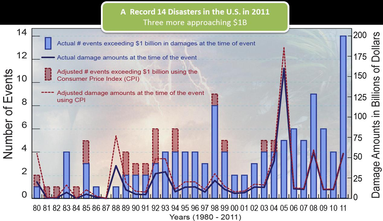
35 Billion Dollar Disasters: Fact of Life
36 Sea Level Trend: Atlantic City, NJ Mean Sea Level Trend


37 Shrewsbury River, NJ

38 Adaptation Costs of Climate Change Risks

39 Managing Risk: Who Pays?


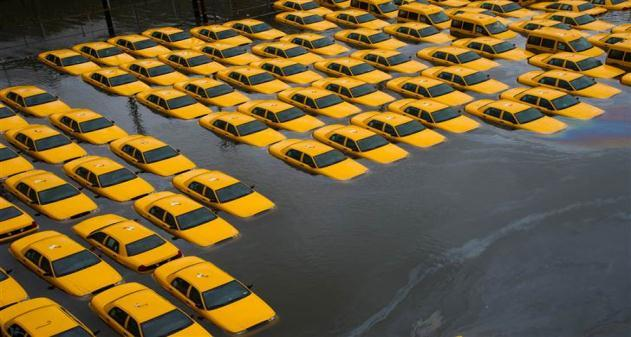


40 Sandy: A Turning Point?

41 Change is Here: Time to Act is Now

42 For More Information
NOAA COASTAL SERVICES CENTER Strategic Plan: 2010 to 2015
 NOAA COASTAL SERVICES CENTER Strategic Plan: 2010 to 2015 N a t i o n a l O c e a n i c a n d A t m o s p h e r i c A d m i n i s t r a t i o n ( N O A A ) C o a s t a l S e r v i c e s C e n t e r March
One Hundred Thirteenth Congress of the United States of America
 H. R. 152 One Hundred Thirteenth Congress of the United States of America AT THE FIRST SESSION Begun and held at the City of Washington on Thursday, the third day of January, two thousand and thirteen
DEPARTMENT OF COMMERCE
 DEPARTMENT OF COMMERCE Funding Highlights: Provides $8.8 billion in base discretionary funding for the Department of Commerce to create the conditions for economic growth by promoting trade and investment,
DISASTER RELIEF APPROPRIATIONS
 PUBLIC LAW 113 2 JAN. 29, 2013 DISASTER RELIEF APPROPRIATIONS VerDate Mar 15 2010 07:40 Feb 15, 2013 Jkt 029139 PO 00002 Frm 00001 Fmt 6579 Sfmt 6579 E:\PUBLAW\PUBL002.113 PUBL002 127 STAT. 4 PUBLIC LAW
Joint Polar Satellite System (JPSS)
") Joint Polar Satellite System (JPSS) John Furgerson, User Liaison Joint Polar Satellite System National Environmental Satellite, Data, and Information Service National Oceanic and Atmospheric Administration
Joint Polar Satellite System (JPSS) John Furgerson, User Liaison Joint Polar Satellite System National Environmental Satellite, Data, and Information Service National Oceanic and Atmospheric Administration
Oregon. Climate Change Adaptation Framework
 Oregon Climate Change Adaptation Framework Oregon Environmental Quality Commission Climate Change Adaptation Framework Presentation at a glance: Purposes of the framework Participating agencies Climate
Global Earth Observation Integrated Data Environment (GEO-IDE) Presentation to the Data Archiving and Access Requirements Working Group (DAARWG)
 Presentation to the Data Archiving and Access Requirements Working Group (DAARWG)") Global Earth Observation Integrated Data Environment (GEO-IDE) Presentation to the Data Archiving and Access Requirements Working Group (DAARWG) Ken McDonald Data Management Integration Architect National
Global Earth Observation Integrated Data Environment (GEO-IDE) Presentation to the Data Archiving and Access Requirements Working Group (DAARWG) Ken McDonald Data Management Integration Architect National
CIESIN Columbia University
 Conference on Climate Change and Official Statistics Oslo, Norway, 14-16 April 2008 The Role of Spatial Data Infrastructure in Integrating Climate Change Information with a Focus on Monitoring Observed
Program Details Notes Flood Mitigation Assistance Program (FMA)
") Federal Emergency Agency Flood Mitigation Assistance (FMA) Provides funding to implement measures to reduce or eliminate the long-term risk of flood damage http://www.fema.gov/government/grant/fma/index.shtm
Federal Emergency Agency Flood Mitigation Assistance (FMA) Provides funding to implement measures to reduce or eliminate the long-term risk of flood damage http://www.fema.gov/government/grant/fma/index.shtm
New York Sea Grant Strategic Plan
 New York Sea Grant Strategic Plan Introduction and Process This is the new strategic plan for New York Sea Grant (NYSG) for the years 2010-2013 as requested by the National Sea Grant Office. This plan
NOAALink Small Business Industry Day. June 2, 2014
 NOAALink Small Business Industry Day June 2, 2014 1 Administrative Notes Restrooms are through the double doors at the rear of the Science Center Attendee list, slide deck, and Q&A will be posted to FBO.gov
Designing and Developing WebGIS SLR tools: NJ Floodmapper
 Designing and Developing WebGIS SLR tools: NJ Floodmapper Richard Lathrop, Lisa Auermuller, Jeanne Herb, Marjorie Kaplan, James Trimble, John Bognar & Jennifer Rovito Coastal Community Resiliency Progression
Submitted to: Fellowship Coordinator NOAA Office of Coastal Management2234 South Hobson Avenue Charleston, SC 29405-2413.
 Tapping Crowd-Sourced Information to Improve Healthy Coastal Ecosystems and make New York Coastal Communities more Resilient: Expanding the New York Geographic Information Gateway (Gateway), a Tool for
OMAO Data Management Roadmap
 OMAO Data Management Roadmap LCDR Mark Van Waes INMARTECH 2014 Corvallis, Oregon November 18, 2014 Ships and aircraft and data, oh my! OMAO HAS DATA? 2 Data Collected by OMAO From NOAA s ships: hydrographic
Future of our coasts: Potential for natural and hybrid infrastructure to enhance ecosystem and community resilience Ariana Sutton-Grier
 Future of our coasts: Potential for natural and hybrid infrastructure to enhance ecosystem and community resilience Ariana Sutton-Grier University of Maryland & National Oceanic and Atmospheric Administration
Malcolm L. Spaulding Professor Emeritus, Ocean Engineering University of Rhode Island Narragansett, RI 02881
 Malcolm L. Spaulding Professor Emeritus, Ocean Engineering University of Rhode Island Narragansett, RI 02881 USACE Coastal and Hydraulics Laboratory(CHL) Data Infrastructure Workshop January 23, 2014 Overview
THE STRATEGIC PLAN OF THE HYDROMETEOROLOGICAL PREDICTION CENTER
 THE STRATEGIC PLAN OF THE HYDROMETEOROLOGICAL PREDICTION CENTER FISCAL YEARS 2012 2016 INTRODUCTION Over the next ten years, the National Weather Service (NWS) of the National Oceanic and Atmospheric Administration
Integrated Water Resources Science and Services. National Water Center
 TOO MUCH POOR QUALITY TOO LITTLE Integrated Water Resources Science and Services and the National Water Center Partnering to Address America s Water Resources Information Needs Mary G. Mullusky National
The Role of Environmental Monitoring and Data Management in Supporting Science to Inform Decision Making: A Case Study
 The Role of Environmental Monitoring and Data Management in Supporting Science to Inform Decision Making: A Case Study Presented by: Dwayne E. Porter Arnold School of Public Health and Baruch Institute
NOAA Sentinel Site Program: San Francisco Bay Area Sentinel Site Cooperative
 NOAA Sentinel Site Program: San Francisco Bay Area Sentinel Site Cooperative Vision: Ensure a San Francisco Bay Area that is resilient to sea level rise through a strong partnership of federal, state,
Florida Institute of Oceanography
 Florida Institute of Oceanography Dr. William T. Hogarth, Interim Director, FIO & Dr. Jyotika I. Virmani, Associate Director, FIO National Water Quality Monitoring Council New Orleans, LA May 3-5, 2011
C oa s ta l M a n a g e m e n t F e l l ow s h i p
 2016 Coastal Management Fellowship WHAT is it? A fellowship established to provide on-the-job education and training opportunities in coastal resource management and policy for postgraduate students. A
Strategic Vision. for Stewarding the Nation s Climate Data. Our. NOAA s National Climatic Data Center
 Strategic Vision Our for Stewarding the Nation s Climate Data NOAA s National Climatic Data Center M AY 2013 Our Strategic Vision for Stewarding the Nation s Climate Data 2 FOREWORD From the Director The
October 15, 2013. Mayor and Council City of New Westminster 511 Royal Avenue New Westminster, BC V3L 1H9
 October 15, 2013 Mayor and Council City of New Westminster 511 Royal Avenue New Westminster, BC V3L 1H9 RE: Business Plan Advancing a Collaborative, Regional Approach to Flood Management in BC s Lower
Doing Business with NASA at the John C. Stennis Space Center, MS
 National Aeronautics and Space Administration Doing Business with NASA at the John C. Stennis Space Center, MS Name: Robert E. Watts Title: Small Business Specialist Date: January 4, 2016 www.nasa.gov
Real-time Ocean Forecasting Needs at NCEP National Weather Service
 Real-time Ocean Forecasting Needs at NCEP National Weather Service D.B. Rao NCEP Environmental Modeling Center December, 2005 HYCOM Annual Meeting, Miami, FL COMMERCE ENVIRONMENT STATE/LOCAL PLANNING HEALTH
Pete Slovinsky, Coastal Geologist, Maine Dept. of Agriculture, Conservation and Forestry
 MEGUG WINTER MEETING AGENDA FEB 2 ND, USM WISHCAMPER CENTER PORTLAND, ME 8:30 9:30am Registration and Poster Setup. Coffee, Tea, and Pastry served. 9:30 10am Opening Remarks, Announcements, and Updates
5 Year Strategic Plan
 Mid Atlantic Fishery Management Council 5 Year Strategic Plan 2014 2018 DRAFT 5/31/2013 Table of Contents Table of Contents... 1 Introduction... 2 The Mid Atlantic Fishery Management Council... 2 Rationale
Environmental Data Services for Delaware:
 Environmental Data Services for Delaware: Serving Emergency Responders, Planners, and Researchers Network Delaware Day November 6, 2013 Overview Operational Data Services More than just research DEOS and
Doing Business with NASA at the John C. Stennis Space Center, MS
 Doing Business with NASA at the John C. Stennis Space Center, MS Name: Robert E. Watts Title: Small Business Specialist Center: John C. Stennis Space Center (SSC) Date: February 18, 2014 Serves as NASA
Business Plan for the. The Geospatial Platform. September 20, 2012 REDACTED
 Business Plan for the Geospatial Platform September 20, 2012 REDACTED The Geospatial Platform Federal Geographic Data Committee Geospatial Platform Business Plan, September 20, 2012 REDACTED 1 The Federal
Resolution XII.13. Wetlands and disaster risk reduction
 12 th Meeting of the Conference of the Parties to the Convention on Wetlands (Ramsar, Iran, 1971) Punta del Este, Uruguay, 1-9 June 2015 Resolution XII.13 Wetlands and disaster risk reduction 1. RECALLING
Flood Risk Management
 Flood Risk Management Value of Flood Risk Management Every year floods sweep through communities across the United States taking lives, destroying property, shutting down businesses, harming the environment
Flood Risk Management
 Flood Risk Management Value of Flood Risk Management Value to Individuals and Communities Every year floods sweep through communities across the United States taking lives, destroying property, shutting
Miami-Dade County Roadmap for Adapting to Coastal Risk
 Miami-Dade County Roadmap for Adapting to Coastal Risk Vulnerability Assessment & Planning Workshop Results & Recommendations Roadmap for Adapting to Coastal Risk Page 1 Introduction GreenPrint is Miami-Dade
2. VA Acquisition Regulation (VAAR) Section Impacted: VAAR 801.603-70(b). 4. Expiration Date: Effective until incorporated into the revised VAAR.
 Section Impacted: VAAR 801.603-70(b). 4. Expiration Date: Effective until incorporated into the revised VAAR.") Department of Veterans Affairs Memorandum Date: November 19, 2014 From: Deputy Senior Procurement Executive Subj: Class Deviation from VA Acquisition Regulation 801.603-70, Representatives of Contracting
Department of Veterans Affairs Memorandum Date: November 19, 2014 From: Deputy Senior Procurement Executive Subj: Class Deviation from VA Acquisition Regulation 801.603-70, Representatives of Contracting
An Update on the Work of the Florida Catastrophic Storm Risk Management Center. Lorilee A. Medders, Ph.D. Director
 An Update on the Work of the Florida Catastrophic Storm Risk Management Center Lorilee A. Medders, Ph.D. Director Florida Hurricane Catastrophe Fund Workshop June 11, 2015 Buena Vista, Florida Section
2015 -- H 5478 S T A T E O F R H O D E I S L A N D
 LC00 01 -- H S T A T E O F R H O D E I S L A N D IN GENERAL ASSEMBLY JANUARY SESSION, A.D. 01 H O U S E R E S O L U T I O N CREATING THE RHODE ISLAND HOUSE COMMISSION ON ECONOMIC RISK DUE TO FLOODING AND
Overview of the US Coral Triangle Initiative Support Program Climate Change Adaptation
 Overview of the US Coral Triangle Initiative Support Program Climate Change Adaptation Britt Parker NOAA Coral Reef Conservation Program rramos 2007 Coral Triangle Initiative & Region www.coraltriangleinitiative.org
Florida Sea Grant College Program
 Florida Sea Grant College Program Strategic Plan 2009 2013 Science Serving Florida s Coast Introduction Florida Sea Grant s Strategic Plan for 2009 to 2013 reflects the input of hundreds of Floridians,
A Proposal to: National Oceanic and Atmospheric Administration, Office of Coastal Management 2016 Coastal Management Fellowship Program
 A Proposal to: National Oceanic and Atmospheric Administration, Office of Coastal Management 2016 Coastal Management Fellowship Program Submitted by: The Nature Conservancy Project Title: Strategic Opportunities
Development of High Resolution Climatologies for Marine Protected Areas
 NCCARF 2010 Interna0onal Climate Change Adapta0on Conference Gold Coast, QLD Australia 29 June 01 July, 2010 Development of High Resolution Climatologies for Marine Protected Areas Karsten Shein 1, Catherine
Monmouth County Preliminary Flood Insurance Study and Flood Insurance Rate Maps Release
 Monmouth County Preliminary Flood Insurance Study and Flood Insurance Rate Maps Release Thomas Song, Program Specialist FEMA Region 2 January 31, 2014 Agenda Introduction Review: Preliminary Work Maps
U.S. Fish and Wildlife Service will invest $15 million for post-sandy cleanup and marsh restoration on Long Island
 For Immediate Release: Wednesday, November 6, 2013 For further information: Michelle Potter, refuge manager, 631/286-0485 ext. 2112, Michelle_Potter@fws.gov Tom Sturm, public affairs specialist, 413/253-8339,
Integrating Near Real-Time Data for Coral Reef Ecosystem Forecasting
 Integrating Near Real-Time Data for Coral Reef Ecosystem Forecasting NOAA s Integrated Coral Observing Network (ICON) Atlantic Oceanographic and Meteorological Laboratory Laboratory Review, March 18, 2008
Oregon Pre-Disaster Mitigation Program Plan Update Training Manual
 FEMA Oregon Pre-Disaster Mitigation Program Plan Update Training Manual Prepared by: Oregon Partnership for Disaster Resilience OPDR FEMA OPDR FEMA OPDR 2010, University of Oregon s Community Service Center
NCDC Strategic Vision
 NOAA s National Climatic Data Center World s Largest Archive of Climate and Weather Data Presented to: Coastal Environmental Disasters Data Management Workshop September 16, 2014 Stephen Del Greco Deputy
Surviving the Storm Economic impacts of an acute flooding event in the Bay Area. Downtown San Anselmo. 2006 New Years Flood
 Surviving the Storm Economic impacts of an acute flooding event in the Bay Area. Downtown San Anselmo. 2006 New Years Flood Bay Area Council Water Committee: ABAG, BCDC, BART, SFO, Port of SF, Port of
ANNOUNCEMENT OF FEDERAL FUNDING OPPORTUNITY EXECUTIVE SUMMARY
 ANNOUNCEMENT OF FEDERAL FUNDING OPPORTUNITY EXECUTIVE SUMMARY Federal Agency Name(s): Oceanic and Atmospheric Research (OAR), National Oceanic and Atmospheric Administration (NOAA), Department of Commerce
End to End Multi Hazard Early Warning Systems By Curt Barrett Hydrometeorological Consultant
 End to End Multi Hazard Early Warning Systems By Curt Barrett Hydrometeorological Consultant Disaster Risk Management- East Asia and Pacific Experts Roundtable on Urban Flood Risk Management March 17,
Public Law 110 394 110th Congress An Act
 122 STAT. 4205 Public Law 110 394 110th Congress An Act To reauthorize and amend the National Sea Grant College Program Act, and for other purposes. Be it enacted by the Senate and House of Representatives
2014-16 NSDI Strategic Plan
 2014-16 NSDI Strategic Plan FY 2015 Status Report December 2015 Federal Geographic Data Committee www.fgdc.gov Contents Overview... 2 Strategic Goal 1 Develop Capabilities for National Shared Services...
Ensuring the Preparedness of Users: NOAA Satellites GOES R, JPSS Laura K. Furgione
 Ensuring the Preparedness of Users: NOAA Satellites GOES R, JPSS Laura K. Furgione U.S. Permanent Representative with the WMO Deputy Director, NOAA s s National Weather Service WMO Executive Council 65
NOAA Big Data Partnership Project Overview
 ACT-IAC ET SIG Analytics and Big Data Committee Monthly Meeting October 21, 2014 NOAA Big Data Partnership Project Overview An ocean of data in the cloud Big Data Partnership Goals and approach Goals Unleash
Climate Change Long Term Trends and their Implications for Emergency Management August 2011
 Climate Change Long Term Trends and their Implications for Emergency Management August 2011 Overview A significant amount of existing research indicates that the world s climate is changing. Emergency
1. GENERAL ADVISORY BASE FLOOD ELEVATION (ABFE) QUESTIONS
 QUESTIONS") INTRODUCTION As communities begin to recover from the devastating effects of Hurricane Sandy, it is important to recognize lessons learned and to employ mitigation actions that ensure structures are rebuilt
INTRODUCTION As communities begin to recover from the devastating effects of Hurricane Sandy, it is important to recognize lessons learned and to employ mitigation actions that ensure structures are rebuilt
NOAA Big Data Project. David Michaud Acting Director, Office of Central Processing Office Monday, August 3, 2015
 NOAA Big Data Project David Michaud Acting Director, Office of Central Processing Office Monday, August 3, 2015 Central Processing Portfolio Benefits and Scope Central Processing Portfolio Benefits Ensures
REQUEST FOR PROPOSAL (RFP) For Consultancy Services
 For Consultancy Services") National Environment & Planning Agency 10 & 11 Caledonia Avenue, Kingston 5, Jamaica W.I. Tel: (876) 754-7540 Fax: (876) 754-7595-6, toll free help-line: 1-888-991-5005 Website: http://www.nepa.gov.jm
National Environment & Planning Agency 10 & 11 Caledonia Avenue, Kingston 5, Jamaica W.I. Tel: (876) 754-7540 Fax: (876) 754-7595-6, toll free help-line: 1-888-991-5005 Website: http://www.nepa.gov.jm
Survey and Mapping Activities in Vietnam *
 UNITED NATIONS E/CONF.100/CRP.1 ECONOMIC AND SOCIAL COUNCIL Eighteenth United Nations Regional Cartographic Conference for Asia and the Pacific Bangkok, 26-29 October 2009 Item 7(a) of the provisional
Saint Petersburg. Bayboro Marine Research Cluster
 Saint Petersburg Bayboro Marine Research Cluster Saint Petersburg At-a-Glance 4th Largest City in Florida (pop. 253,902) Median Age has dropped to 39 from 49 since 1970 $635 million Construction value
Residual Markets. Residual Markets in which insurers participate to make coverage available to those unable to obtain coverage in Standard Market
 Residual Markets David C. Marlett, PhD, CPCU Chair, Department of Finance, Banking and Insurance Appalachian State University marlettdc@appstate.edu 828.262.2849 http://insurance.appstate.edu/ Residual
Subactivity: Habitat Conservation Program Element: National Wetlands Inventory
 HABITAT CONSERVATION FY 29 BUDGET JUSTIFICATION Subactivity: Habitat Conservation Program Element: National Wetlands Inventory National Wetlands Inventory ($) FTE 27 4,7 2 28 Enacted 5,255 2 Fixed Costs
3. The submittal shall include a proposed scope of work to confirm the provided project description;
 QIN Shoreline Master Program Project Summary The Shoreline Master Program (SMP) development process for the Quinault Indian Nation (QIN) includes the completion of inventory and analysis report with corresponding
The role of the Ina-SDI in supporting the development of the geospatial industry in Indonesia
 GEOGRAFIA Online TM Malaysia Journal of Society and Space 8 issue 1 (69-79) 69 The role of the Ina-SDI in supporting the development of the geospatial industry in Indonesia Asep Karsidi 1 National Coordinating
PROGRESS MADE IN IMPLEMENTING THE OCEAN AND COASTAL MAPPING INTEGRATION ACT: 2009-2010
 Biennial Report to Congress: PROGRESS MADE IN IMPLEMENTING THE OCEAN AND COASTAL MAPPING INTEGRATION ACT: 2009-2010 PRODUCT OF THE Committee on Environment, Natural Resources, and Sustainability OF THE
National Data Buoy Center Cooperative Relations
 National Data Buoy Center Cooperative Relations Presentation For NGI Annual Conference May 23, 2012 Landry Bernard National Data Buoy Center Operational Mission To provide a real-time, end-to-end capability
Institute for Risk and Disaster Reduction University College London
 Institute for Risk and Disaster Reduction University College London Wilkins Building South Wing, UCL, Gower Street London, England, WC1E 6BT www.ucl.ac.uk/rdr Outline Reducing the impact of disasters globally
COASTAL MONITORING & OBSERVATIONS LESSON PLAN Do You Have Change?
 Coastal Change Analysis Lesson Plan COASTAL MONITORING & OBSERVATIONS LESSON PLAN Do You Have Change? NOS Topic Coastal Monitoring and Observations Theme Coastal Change Analysis Links to Overview Essays
EMBARGOED UNTIL 6:00AM ET, WEDNESDAY, May 14, 2014. THE WHITE HOUSE Office of the Press Secretary EMBARGOED UNTIL 6:00AM ET, WEDNESDAY, May 14, 2014
 THE WHITE HOUSE Office of the Press Secretary EMBARGOED UNTIL 6:00AM ET, WEDNESDAY, May 14, 2014 FACT SHEET Building a 21 st Century Infrastructure: Modernizing Infrastructure Permitting Building a 21
Ocean Engineering, Surveying and Mapping Services
 Ocean Engineering, Surveying and Mapping Services FUGRO PELAGOS, INC. Fugro collects and interprets data related to the earth s surface and the soils and rocks beneath. It provides advice based on the
Federal Emergency Management Agency (FEMA) Preliminary Flood Insurance Rate Maps (FIRMs) and Preliminary Flood Insurance Study (FIS) for New York City
 Preliminary Flood Insurance Rate Maps (FIRMs) and Preliminary Flood Insurance Study (FIS) for New York City") March 10, 2014 Submitted electronically via http://www.nyc.gov Mayor s Office of Long Term Planning and Sustainability c/o Flood Map Comments 253 Broadway, 10th Floor New York, NY 10007 Federal Emergency
March 10, 2014 Submitted electronically via http://www.nyc.gov Mayor s Office of Long Term Planning and Sustainability c/o Flood Map Comments 253 Broadway, 10th Floor New York, NY 10007 Federal Emergency
OUR CHAT WITH MITCHELL J. ROSS MICHAEL FISCHETTI:
 34 Contract Management January 2015 Contract Management January 2015 35 MICHAEL FISCHETTI: Please introduce yourself to our readers. What is your current title and responsibilities? What previous titles
Request for Proposal. Request for Proposal for GreenLink Bellingham Technical Analysis and Community Engagement, Bellingham, WA
 Request for Proposal Request for Proposal for GreenLink Bellingham Technical Analysis and Community Engagement, Bellingham, WA 1 Table of Contents: Section A: Project Scope... 3 Section B: Background...
ANNOUNCEMENT OF FEDERAL FUNDING OPPORTUNITY EXECUTIVE SUMMARY
 ANNOUNCEMENT OF FEDERAL FUNDING OPPORTUNITY EXECUTIVE SUMMARY Federal Agency Name(s): Oceanic and Atmospheric Research (OAR), National Oceanic And Atmospheric Administration, Department of Commerce Funding
U.S. COMMERCIAL REMOTE SENSING POLICY. April 25, 2003 FACT SHEET
 U.S. COMMERCIAL REMOTE SENSING POLICY April 25, 2003 FACT SHEET The President authorized a new national policy on April 25, 2003 that establishes guidance and implementation actions for commercial remote
Strategic Activities to Support Sustainability of Canada s Geospatial Data Infrastructure
 Strategic Activities to Support Sustainability of Canada s Geospatial Data Infrastructure Paula McLeod Canada Centre for Mapping and Earth Observation United Nations 10 th Regional Cartographic Conference
Coastal Erosion Risk Mitigation Strategies applied in a Small Island Developing State: The Barbados Model
 Coastal Erosion Risk Mitigation Strategies applied in a Small Island Developing State: The Barbados Model BY Dr. Leo Brewster, Director Coastal Zone Management Unit, Barbados Presented At UNFCCC Expert
APPENDIX C LIST OF EA RECIPIENTS
 APPENDIX C APPENDIX C LIST OF RECIPIENTS C.1 Federal Agencies Advisory Council on Historic Preservation, Office of Cultural Resources Preservation U.S. Army Corps of Engineers, District Engineer, Regulatory
National Oceanic and Atmospheric Administration Weather-Ready Nation Saving Lives and Livelihoods
 National Oceanic and Atmospheric Administration Weather-Ready Nation Saving Lives and Livelihoods Unidata Policy Committee May 14, 2012 LeRoy Spayd NOAA/NWS 1 Outline NWS Weather Ready Nation NOAA Budget
Office of Emergency Management
 Emergency Management Mission In cooperation with internal and external partners, enhance public protective actions and promote domestic preparedness through a comprehensive and effective emergency management
American Planning Association
 American Planning Association Planning for Post-Disaster Recovery Session 2 Moderator: James Schwab, AICP, APA Speakers: Laurie A. Johnson, AICP, Laurie Johnson Consulting Lincoln Walther, FAICP, CSA Ocean
Building Caribbean GeoNode Platform in Support of Climate Risk Management Jacob Opadeyi, PhD
 Building Caribbean GeoNode Platform in Support of Climate Risk Management Jacob Opadeyi, PhD Our Highly Vulnerable Region Housing developments on drainage channels and steep slopes Unapproved development
Climate Service - Questions and Answers Updated: February 15, 2011
 Climate Service - Questions and Answers Updated: February 15, 2011 Table of Contents Next Steps and Timeframe...1 Need and Purpose...1 Funding/Budget...6 Organizational Structure...7 Federal Agency Coordination...8
Federal Arctic Policy, Management, and Research Pat Pourchot
 Federal Arctic Policy, Management, and Research Pat Pourchot Special Assistant to the Secretary of the Interior for Alaska Affairs The Federal Players Major Departments/Agencies: Department of the Interior
Getting Involved: Cooperative Program and Grant Opportunities for Fishermen in the South Atlantic Region An Overview
 Getting Involved: Cooperative Program and Grant Opportunities for Fishermen in the South Atlantic Region An Overview Fisheries managers often receive questions from fishermen regarding opportunities to
The Copernicus Marine Enviroment Monitoring Service
 The Copernicus Marine Enviroment Monitoring Service P.Y. Le Traon 7&8 Sep 2015 - CMEMS SE & UU Workshop, Brussels 1 CMEMS : The Copernicus Marine Environment Monitoring Service SATELLITES (S1, S3, Jason-CS)
Section 7.Plan Maintenance
 Section 7. Plan Maintenance 2014 Plan Update Changes The SHMT meeting schedule has been adjusted from quarterly to bi-yearly. Institutes a yearly plan evaluation and update cycle. Points of contact for
Martin County Coastal GIS Program St Lucie Inlet Planning Tool
 Martin County Coastal GIS Program St Lucie Inlet Planning Tool Alexandra Carvalho, Ph.D., GISP Kathy Fitzpatrick, P.E. Jessica Garland Martin County, Florida Presentation Overview County Coastal Programs
CUSTOMER KEYNOTE Hal Buddenbohm
 CUSTOMER KEYNOTE Hal Buddenbohm Supply Chain Director ITT Force Protection Systems Hal Buddenbohm is the Supply Chain Director at ITT Force Protection Systems in Thousand Oaks, CA. Prior to joining ITT,
Using Message Brokering and Data Mediation to use Distributed Data Networks of Earth Science Data to Enhance Global Maritime Situational Awareness.
 Using Message Brokering and Data Mediation to use Distributed Data Networks of Earth Science Data to Enhance Global Maritime Situational Awareness. Conor Delaney, Alfredo Alessandrini & Harm Greidanus
How To Create A Cloud Data Service For Noaa
 NOAA Big Data Partnership Ground System Architecture Workshop, Los Angeles CA 2015 Mar 04 Jeff de La Beaujardière, PhD NOAA Data Management Architect jeff.delabeaujardiere@noaa.gov 1 end users application
CALIFORNIA OCEAN PROTECTION COUNCIL. Staff Recommendation March 11, 2011 STATEWIDE SCIENCE INTEGRATION AND MARINE PROTECTED AREA MONITORING PROGRAMS
 CALIFORNIA OCEAN PROTECTION COUNCIL Staff Recommendation March 11, 2011 STATEWIDE SCIENCE INTEGRATION AND MARINE PROTECTED AREA MONITORING PROGRAMS File No.: 08-123-02 File No.: 06-090-02 Project Managers:
EPA Trends for wastewater Treatment in California - 2011
 EPA S TECHNOLOGY NEEDS FOR THE WATER AND WASTEWATER INDUSTRY Nancy Stoner Acting Assistant Administrator U.S. EPA Office of Water International Emerging Technology Symposium Arlington, VA April 23rd, 2014
Coastal Research Proposal Abstracts
 Coastal Research Proposal Abstracts An Automated Data Analysis, Processing, and Management System Proposal to NASA with SAIC Total Budget $15K Submitted 10/31/2008 The goal of this study is to design,
Flood Risk and Visual Communication Techniques
 FLOOD RISK AND UNCERTAINTY Assessing the National Weather Service s Flood Forecast and Warning Tools Rachel Hogan Carr Delaware River Basin Commission December 3, 2014 Nurture Nature Center is a non-profit
DIVISION OF EMERGENCY MANAGEMENT
 DIVISION OF EMERGENCY MANAGEMENT PROGRAM DESCRIPTION The Florida Division of Emergency Management (DEM) is responsible for maintaining a comprehensive statewide program of emergency management. In addition,
CONTINUING EROSION IN SOUTHEASTERN COASTAL MISSISSIPPI - POINT AUX CHENES BAY, WEST GRAND BAY, MIDDLE BAY, GRANDE BATTURE ISLANDS: 1995-1997
 Summary of a Poster Presented at the: Sixty-Second Annual Meeting of the Mississippi Academy of Sciences in Biloxi, Mississippi February 26-27, 1998 ===============================================================
Performs the Federal coordination role for supporting the energy requirements associated with National Special Security Events.
 ESF Coordinator: Energy Primary Agency: Energy Support Agencies: Agriculture Commerce Defense Homeland Security the Interior Labor State Transportation Environmental Protection Agency Nuclear Regulatory
PMEL Press Releases and NOAA News Stories FY09- FY14
 PMEL Press Releases and NOAA News Stories FY09- FY14 PMEL WIDE Oceanographer named to head NOAA s Seattle research laboratory http://www.noaanews.noaa.gov/stories2011/20111018_pmel.html CLIMATE THEME most
FLORIDA SEA GRANT COLLEGE PROGRAM Priorities & Funding Opportunities for 2016-2017
 FLORIDA SEA GRANT COLLEGE PROGRAM Priorities & Funding Opportunities for 2016-2017 Call for Statements of Interest for Proposed New Applied Research Projects Deadline: February 13, 2015 (4:00 PM Eastern