Automated Feature Extraction from Aerial Imagery for Forestry Projects
|
|
|
- Derick Wood
- 7 years ago
- Views:
Transcription
1 Automated Feature Extraction from Aerial Imagery for Forestry Projects Esri UC 2015 UC706 Tuesday July 21 Bart Matthews - Photogrammetrist US Forest Service Southwestern Region Brad Weigle Sr. Program Manager Quantum Spatial
2 The Power of 4

3 Imagery of the Planet Major Advances over 85 years USDA B&W 50cm 1930s-1960s Digital 4-band 5cm s - Present LANDSAT 30m 1970s - Present RGB, NIR Film 1m 1960s 2000s

4 LARGE FORMAT DIGITAL AERIAL CAMERAS ULTRACAM EAGLE ADS 100 DMC ii
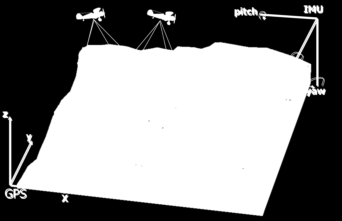
5 GPS & IMU
 - Digital Terrain Model (DTM) - Triangulated Irregular")
6 Imagery for Topography The forms of the features of the actual surface of the earth which is typically referred to as the Bare Earth. There are three primary terms for topography: - Digital Elevation Model (DEM) - Digital Terrain Model (DTM) - Triangulated Irregular Network (TIN)

7 Digital Surface Model (DSM) Similar to DEMs or DTMs, except that they may depict the elevations of the top surfaces of buildings, trees, towers, and other features elevated above the bare earth.

8 DIGITAL SURFACE MODEL DIGITAL ELEVATION MODEL DSM DEM = Height of features (ndsm or PHASE)
9 Region 3 Forests with Digital Orthophotography Recent Imagery: 4 band, 30cm pixels, 60% overlap, 30% sidelap

10 ERDAS IMAGINE Block Files - an Aerial Triangulation Solution for Orthophoto Production & Stereo Analysis - a starting point to produce point clouds

11 Point Clouds for Automated Imagery Analysis Software to Create: Image Station, ERDAS, SocetSet, Inpho, Product: High resolution 3D point clouds from stereo images points tagged with spectral info and height above sea level

12 We have developed analytical models to derive vegetation type, height, & canopy closure even in areas with poor DEMs Maximum point densities from pixels: 50cm = 4 pts/m 2 30cm = 9 pts/m 2 10cm = 100 pts/m 2 5cm = 400 pts/m 2

13 R3 Riparian Inventory Pilot Build on Regional Riparian Mapping Project Report and Pilot Project Protocols - analogous to FIA 1ha riparian plots in Cibola and Prescott NFs Interpret vegetation, bank and stream characteristics using 5-8cm stereo aerial photos in Stereo Analyst & Modelbuilder Automate measurements using derivatives from image point clouds using Modelbuilder

14 Modelbuilder: densify riparian centerlines & select sample locations Centerlines of riparian polygons densified to 1m vertex spacing Randomized starting location Systematic site selection at 25600m intervals Additional selection until all riparian types have 10+ sites
15 Modelbuilder Toolbox for Automated Calculations Manually digitize R&L banks in 3D using Stereo Analyst Models: Divide R&L banks into 50 sample sites Join R&L banks to create transects Divide transects into 5 sample points Measure 3D depth: transect point to bed Determine flood plain along streambed Calculate sinuosity & stream type
 Characterize distribution of PHASE for Individual Polygons Classify polygons with Tree Size and")
16 Other Projects: Determining Tree Size (DBH) from Point Clouds Determine Species Composition of homogenous polygons Create Point Clouds from Stereo Imagery Use FIA data to correlate Spp. Height to DBH Use Modelbuilder to: Determine Pixel Heights above Surface (PHASE = DSM DEM) Characterize distribution of PHASE for Individual Polygons Classify polygons with Tree Size and Canopy Cover
17 Estimating Tree Size Classes using FIA data Ponderosa Pine 40 Douglas Fir R² = R² = Lodgepole Pine Douglas Fir - Ponderosa Pine R² = R² =

18 FIA plot TS6 Point cloud TS6 FIA plot TS6 Point cloud TS3

19 Vegetation Mapping in Oregon

20 LiDAR / Image Cloud Comparison

21 LiDAR / Image Cloud Comparison

22 LiDAR / Image Cloud Comparison Up to 60 cm offset & 10 cm or less near ground control
23 In Conclusion Modelbuilder works extremely well to automate geospatial processing of point cloud rasters and production of derivative data layers Point clouds derived from stereo pairs are acceptable alternatives to LiDAR for determining vegetation types, tree heights and canopy closure LiDAR is preferred, but a more costly option, for an accurate DEM & detailed forest structure Historic aerial imagery can provide valuable data for change detection and vegetation growth patterns a virtual timemachine Scanning of historic imagery to digital format is ESSENTIAL before film degrades to ensure time-series analysis.
24 Our Contact Information Bart Matthews - Photogrammetrist US Forest Service Southwestern Region bartmatthews@fs.fed.us (505) Brad Weigle Sr. Program Manager Quantum Spatial bweigle@quantumspatial.com (727)
How To Make An Orthophoto
 ISSUE 2 SEPTEMBER 2014 TSA Endorsed by: CLIENT GUIDE TO DIGITAL ORTHO- PHOTOGRAPHY The Survey Association s Client Guides are primarily aimed at other professionals such as engineers, architects, planners
Opportunities for the generation of high resolution digital elevation models based on small format aerial photography
 Opportunities for the generation of high resolution digital elevation models based on small format aerial photography Boudewijn van Leeuwen 1, József Szatmári 1, Zalán Tobak 1, Csaba Németh 1, Gábor Hauberger
The following was presented at DMT 14 (June 1-4, 2014, Newark, DE).
.") DMT 2014 The following was presented at DMT 14 (June 1-4, 2014, Newark, DE). The contents are provisional and will be superseded by a paper in the DMT 14 Proceedings. See also presentations and Proceedings
DMT 2014 The following was presented at DMT 14 (June 1-4, 2014, Newark, DE). The contents are provisional and will be superseded by a paper in the DMT 14 Proceedings. See also presentations and Proceedings
LiDAR Data Management Lessons for Geospatial Data Managers
 LiDAR Data Management Lessons for Geospatial Data Managers By: Morris County Department of Planning, Development & Technology Background 2005 Morris County LiDAR Acquisition 5 year Orthophotography Plan
Managing Lidar (and other point cloud) Data. Lindsay Weitz Cody Benkelman
 Data. Lindsay Weitz Cody Benkelman") (and other point cloud) Data Lindsay Weitz Cody Benkelman Presentation Context What is lidar, and how does it work? Not this presentation! What can you do with lidar in ArcGIS? What does Esri recommend
(and other point cloud) Data Lindsay Weitz Cody Benkelman Presentation Context What is lidar, and how does it work? Not this presentation! What can you do with lidar in ArcGIS? What does Esri recommend
Point Clouds: Big Data, Simple Solutions. Mike Lane
 Point Clouds: Big Data, Simple Solutions Mike Lane Light Detection and Ranging Point Cloud is the Third Type of Data Vector Point Measurements and Contours Sparse, highly irregularly spaced X,Y,Z values
3D Model of the City Using LiDAR and Visualization of Flood in Three-Dimension
 3D Model of the City Using LiDAR and Visualization of Flood in Three-Dimension R.Queen Suraajini, Department of Civil Engineering, College of Engineering Guindy, Anna University, India, suraa12@gmail.com
LIDAR and Digital Elevation Data
 LIDAR and Digital Elevation Data Light Detection and Ranging (LIDAR) is being used by the North Carolina Floodplain Mapping Program to generate digital elevation data. These highly accurate topographic
Introduction to Imagery and Raster Data in ArcGIS
 Esri International User Conference San Diego, California Technical Workshops July 25, 2012 Introduction to Imagery and Raster Data in ArcGIS Simon Woo slides Cody Benkelman - demos Overview of Presentation
A Method Using ArcMap to Create a Hydrologically conditioned Digital Elevation Model
 A Method Using ArcMap to Create a Hydrologically conditioned Digital Elevation Model High resolution topography derived from LiDAR data is becoming more readily available. This new data source of topography
3D Point Cloud Analytics for Updating 3D City Models
 3D Point Cloud Analytics for Updating 3D City Models Rico Richter 25 th May 2015 INSPIRE - Geospatial World Forum 2015 Background Hasso Plattner Institute (HPI): Computer Graphics Systems group of Prof.
Photogrammetric Point Clouds
 Photogrammetric Point Clouds Origins of digital point clouds: Basics have been around since the 1980s. Images had to be referenced to one another. The user had to specify either where the camera was in
Understanding Raster Data
 Introduction The following document is intended to provide a basic understanding of raster data. Raster data layers (commonly referred to as grids) are the essential data layers used in all tools developed
Files Used in this Tutorial
 Generate Point Clouds Tutorial This tutorial shows how to generate point clouds from IKONOS satellite stereo imagery. You will view the point clouds in the ENVI LiDAR Viewer. The estimated time to complete
Inventory Enhancements
 Inventory Enhancements Chapter 6 - Vegetation Inventory Standards and Data Model Documents Resource Information Management Branch, Table of Contents 1. DETECTION OF CONIFEROUS UNDERSTOREY UNDER DECIDUOUS
MULTIPURPOSE USE OF ORTHOPHOTO MAPS FORMING BASIS TO DIGITAL CADASTRE DATA AND THE VISION OF THE GENERAL DIRECTORATE OF LAND REGISTRY AND CADASTRE
 MULTIPURPOSE USE OF ORTHOPHOTO MAPS FORMING BASIS TO DIGITAL CADASTRE DATA AND THE VISION OF THE GENERAL DIRECTORATE OF LAND REGISTRY AND CADASTRE E.ÖZER, H.TUNA, F.Ç.ACAR, B.ERKEK, S.BAKICI General Directorate
ANALYSIS 3 - RASTER What kinds of analysis can we do with GIS?
 ANALYSIS 3 - RASTER What kinds of analysis can we do with GIS? 1. Measurements 2. Layer statistics 3. Queries 4. Buffering (vector); Proximity (raster) 5. Filtering (raster) 6. Map overlay (layer on layer
Digital Classification and Mapping of Urban Tree Cover: City of Minneapolis
 Digital Classification and Mapping of Urban Tree Cover: City of Minneapolis FINAL REPORT April 12, 2011 Marvin Bauer, Donald Kilberg, Molly Martin and Zecharya Tagar Remote Sensing and Geospatial Analysis
Nature Values Screening Using Object-Based Image Analysis of Very High Resolution Remote Sensing Data
 Nature Values Screening Using Object-Based Image Analysis of Very High Resolution Remote Sensing Data Aleksi Räsänen*, Anssi Lensu, Markku Kuitunen Environmental Science and Technology Dept. of Biological
Notable near-global DEMs include
 Visualisation Developing a very high resolution DEM of South Africa by Adriaan van Niekerk, Stellenbosch University DEMs are used in many applications, including hydrology [1, 2], terrain analysis [3],
METHODOLOGY FOR LANDSLIDE SUSCEPTIBILITY AND HAZARD MAPPING USING GIS AND SDI
 The 8th International Conference on Geo-information for Disaster Management Intelligent Systems for Crisis Management METHODOLOGY FOR LANDSLIDE SUSCEPTIBILITY AND HAZARD MAPPING USING GIS AND SDI T. Fernández
3-D Object recognition from point clouds
 3-D Object recognition from point clouds Dr. Bingcai Zhang, Engineering Fellow William Smith, Principal Engineer Dr. Stewart Walker, Director BAE Systems Geospatial exploitation Products 10920 Technology
Remote Sensing Method in Implementing REDD+
 Remote Sensing Method in Implementing REDD+ FRIM-FFPRI Research on Development of Carbon Monitoring Methodology for REDD+ in Malaysia Remote Sensing Component Mohd Azahari Faidi, Hamdan Omar, Khali Aziz
ENVI THE PREMIER SOFTWARE FOR EXTRACTING INFORMATION FROM GEOSPATIAL IMAGERY.
 ENVI THE PREMIER SOFTWARE FOR EXTRACTING INFORMATION FROM GEOSPATIAL IMAGERY. ENVI Imagery Becomes Knowledge ENVI software uses proven scientific methods and automated processes to help you turn geospatial
Lidar 101: Intro to Lidar. Jason Stoker USGS EROS / SAIC
 Lidar 101: Intro to Lidar Jason Stoker USGS EROS / SAIC Lidar Light Detection and Ranging Laser altimetry ALTM (Airborne laser terrain mapping) Airborne laser scanning Lidar Laser IMU (INS) GPS Scanning
A GIS helps you answer questions and solve problems by looking at your data in a way that is quickly understood and easily shared.
 A Geographic Information System (GIS) integrates hardware, software, and data for capturing, managing, analyzing, and displaying all forms of geographically referenced information. GIS allows us to view,
LiDAR Point Cloud Processing with
 LiDAR Research Group, Uni Innsbruck LiDAR Point Cloud Processing with SAGA Volker Wichmann Wichmann, V.; Conrad, O.; Jochem, A.: GIS. In: Hamburger Beiträge zur Physischen Geographie und Landschaftsökologie
VCS REDD Methodology Module. Methods for monitoring forest cover changes in REDD project activities
 1 VCS REDD Methodology Module Methods for monitoring forest cover changes in REDD project activities Version 1.0 May 2009 I. SCOPE, APPLICABILITY, DATA REQUIREMENT AND OUTPUT PARAMETERS Scope This module
Introduction to GIS (Basics, Data, Analysis) & Case Studies. 13 th May 2004. Content. What is GIS?
 & Case Studies. 13 th May 2004. Content. What is GIS?") Introduction to GIS (Basics, Data, Analysis) & Case Studies 13 th May 2004 Content Introduction to GIS Data concepts Data input Analysis Applications selected examples What is GIS? Geographic Information
Introduction to GIS (Basics, Data, Analysis) & Case Studies 13 th May 2004 Content Introduction to GIS Data concepts Data input Analysis Applications selected examples What is GIS? Geographic Information
Geospatial Software Solutions for the Environment and Natural Resources
 Geospatial Software Solutions for the Environment and Natural Resources Manage and Preserve the Environment and its Natural Resources Our environment and the natural resources it provides play a growing
Objectives. Raster Data Discrete Classes. Spatial Information in Natural Resources FANR 3800. Review the raster data model
 Spatial Information in Natural Resources FANR 3800 Raster Analysis Objectives Review the raster data model Understand how raster analysis fundamentally differs from vector analysis Become familiar with
INVESTIGA I+D+i 2013/2014
 INVESTIGA I+D+i 2013/2014 SPECIFIC GUIDELINES ON AEROSPACE OBSERVATION OF EARTH Text by D. Eduardo de Miguel October, 2013 Introducction Earth observation is the use of remote sensing techniques to better
Image Analysis CHAPTER 16 16.1 ANALYSIS PROCEDURES
 CHAPTER 16 Image Analysis 16.1 ANALYSIS PROCEDURES Studies for various disciplines require different technical approaches, but there is a generalized pattern for geology, soils, range, wetlands, archeology,
Cost Considerations of Using LiDAR for Timber Inventory 1
 Cost Considerations of Using LiDAR for Timber Inventory 1 Bart K. Tilley, Ian A. Munn 3, David L. Evans 4, Robert C. Parker 5, and Scott D. Roberts 6 Acknowledgements: Mississippi State University College
AN INVESTIGATION OF THE GROWTH TYPES OF VEGETATION IN THE BÜKK MOUNTAINS BY THE COMPARISON OF DIGITAL SURFACE MODELS Z. ZBORAY AND E.
 ACTA CLIMATOLOGICA ET CHOROLOGICA Universitatis Szegediensis, Tom. 38-39, 2005, 163-169. AN INVESTIGATION OF THE GROWTH TYPES OF VEGETATION IN THE BÜKK MOUNTAINS BY THE COMPARISON OF DIGITAL SURFACE MODELS
National and Sub-national Carbon monitoring tools developed at the WHRC
 National and Sub-national Carbon monitoring tools developed at the WHRC Nadine Laporte Woods Hole Research Center A. Baccini, W. Walker, S. Goetz, M. Sun, J. Kellndorfer Kigali, 20 th June 2011 Why measuring
5. GIS, Cartography and Visualization of Glacier Terrain
 5. GIS, Cartography and Visualization of Glacier Terrain 5.1. Garhwal Himalayan Glaciers 5.1.1. Introduction GIS is the computer system for capturing, storing, analyzing and visualization of spatial and
Image Draping & navigation within Virtual GIS
 Image Draping & navigation within Virtual GIS Draping of Geo Corrected data such as aerial imagery or map data enables virtual 3D field tours to be conducted in an area of interest. This document covers
Coastal Engineering Indices to Inform Regional Management
 Coastal Engineering Indices to Inform Regional Management Lauren Dunkin FSBPA 14 February 2013 Outline Program overview Standard products Coastal Engineering Index Conclusion and future work US Army Corps
STATE OF NEVADA Department of Administration Division of Human Resource Management CLASS SPECIFICATION
 STATE OF NEVADA Department of Administration Division of Human Resource Management CLASS SPECIFICATION TITLE PHOTOGRAMMETRIST/CARTOGRAPHER V 39 6.102 PHOTOGRAMMETRIST/CARTOGRAPHER II 33 6.110 PHOTOGRAMMETRIST/CARTOGRAPHER
Digital Orthophoto Production In the Desktop Environment 1
 Digital Orthophoto Production In the Desktop Environment 1 By Dr. Roy A. Welch and Thomas R. Jordan Digital orthophotos are proving suitable for a variety of mapping, GIS and environmental monitoring tasks.
Lidar Remote Sensing for Forestry Applications
 Lidar Remote Sensing for Forestry Applications Ralph O. Dubayah* and Jason B. Drake** Department of Geography, University of Maryland, College Park, MD 0 *rdubayah@geog.umd.edu **jasdrak@geog.umd.edu 1
FOREST PARAMETER ESTIMATION BY LIDAR DATA PROCESSING
 P.-F. Mursa Forest parameter estimation by LIDAR data processing FOREST PARAMETER ESTIMATION BY LIDAR DATA PROCESSING Paula-Florina MURSA, Master Student Military Technical Academy, paula.mursa@gmail.com
REGISTRATION OF LASER SCANNING POINT CLOUDS AND AERIAL IMAGES USING EITHER ARTIFICIAL OR NATURAL TIE FEATURES
 REGISTRATION OF LASER SCANNING POINT CLOUDS AND AERIAL IMAGES USING EITHER ARTIFICIAL OR NATURAL TIE FEATURES P. Rönnholm a, *, H. Haggrén a a Aalto University School of Engineering, Department of Real
RESOLUTION MERGE OF 1:35.000 SCALE AERIAL PHOTOGRAPHS WITH LANDSAT 7 ETM IMAGERY
 RESOLUTION MERGE OF 1:35.000 SCALE AERIAL PHOTOGRAPHS WITH LANDSAT 7 ETM IMAGERY M. Erdogan, H.H. Maras, A. Yilmaz, Ö.T. Özerbil General Command of Mapping 06100 Dikimevi, Ankara, TURKEY - (mustafa.erdogan;
.FOR. Forest inventory and monitoring quality
 .FOR Forest inventory and monitoring quality FOR : the asset to manage your forest patrimony 2 1..FOR Presentation.FOR is an association of Belgian companies, created in 2010 and supported by a university
AN INTEGRATED WORKFLOW FOR LIDAR / OPTICAL DATA MAPPING FOR SECURITY APPLICATIONS
 AN INTEGRATED WORKFLOW FOR LIDAR / OPTICAL DATA MAPPING FOR SECURITY APPLICATIONS Dirk Tiede, Thomas Blaschke Z_GIS; Centre for GeoInformatics, University of Salzburg, Hellbrunnerstrasse 34, 5020 Salzburg,
Managing Imagery and Raster Data in ArcGIS
 Technical Workshops Managing Imagery and Raster Data in ArcGIS Hong Xu, Sangeet Mathew, Mark Harris Presentation Overview ArcGIS raster data models Which model to use Mosaic dataset storage and properties
IMPERVIOUS SURFACE MAPPING UTILIZING HIGH RESOLUTION IMAGERIES. Authors: B. Acharya, K. Pomper, B. Gyawali, K. Bhattarai, T.
 IMPERVIOUS SURFACE MAPPING UTILIZING HIGH RESOLUTION IMAGERIES Authors: B. Acharya, K. Pomper, B. Gyawali, K. Bhattarai, T. Tsegaye ABSTRACT Accurate mapping of artificial or natural impervious surfaces
Preface. Ko Ko Lwin Division of Spatial Information Science University of Tsukuba 2008
 1 Preface Remote Sensing data is one of the primary data sources in GIS analysis. The objective of this material is to provide fundamentals of Remote Sensing technology and its applications in Geographical
High Resolution RF Analysis: The Benefits of Lidar Terrain & Clutter Datasets
 0 High Resolution RF Analysis: The Benefits of Lidar Terrain & Clutter Datasets January 15, 2014 Martin Rais 1 High Resolution Terrain & Clutter Datasets: Why Lidar? There are myriad methods, techniques
3D Building Roof Extraction From LiDAR Data
 3D Building Roof Extraction From LiDAR Data Amit A. Kokje Susan Jones NSG- NZ Outline LiDAR: Basics LiDAR Feature Extraction (Features and Limitations) LiDAR Roof extraction (Workflow, parameters, results)
Information Contents of High Resolution Satellite Images
 Information Contents of High Resolution Satellite Images H. Topan, G. Büyüksalih Zonguldak Karelmas University K. Jacobsen University of Hannover, Germany Keywords: satellite images, mapping, resolution,
Technologies Enabling the Evolution of a Smart City. Brad Schmidt, Intergraph Canada
 Technologies Enabling the Evolution of a Smart City Brad Schmidt, Intergraph Canada AGENDA The Smart City Key Challenges Facing Cities Technology Challenges Smart Sensor Integration Smart Apps Smart Data
<Insert Picture Here> Data Management Innovations for Massive Point Cloud, DEM, and 3D Vector Databases
 Data Management Innovations for Massive Point Cloud, DEM, and 3D Vector Databases Xavier Lopez, Director, Product Management 3D Data Management Technology Drivers: Challenges & Benefits
EVALUATION OF AIRBORNE LIDAR DIGITAL TERRAIN MAPPING FOR HIGHWAY CORRIDOR PLANNING AND DESIGN
 Waheed Uddin Director, Center for Advanced Infrastructure Technology, Carrier Hall 203 The University of Mississippi, University, MS 38677-1848, USA cvuddin@olemiss.edu KEY WORDS: Terrain, mapping, airborne,
The X100. Safe and fully automatic. Fast and with survey accuracy. revolutionary mapping. create your own orthophotos and DSMs
 The X100 revolutionary mapping Safe and fully automatic create your own orthophotos and DSMs Fast and with survey accuracy operates even in harsh weather conditions (up to 65 km/h wind & light rain) Image
How To Read Maps And Aerial Photos
 3 Read Maps and Aerial Photos WRITING SAMPLE (training guide) Stephen X. Arthur, technical writer 2005 www.transcanfilm.com/stephenarthur First draft. Copyright 1996, BC Ministry of Forests / BC Institute
Request For Proposal 2012 Digital Orthophotography
 1. RFP Purpose Request For Proposal 2012 Digital Orthophotography The South Mississippi Aerial Photography (SMAPI) is seeking proposals from qualified firms to acquire color, six-inch for 1 :100 scale
A KNOWLEDGE-BASED APPROACH FOR REDUCING CLOUD AND SHADOW ABSTRACT
 A KNOWLEDGE-BASED APPROACH FOR REDUCING CLOUD AND SHADOW Mingjun Song, Graduate Research Assistant Daniel L. Civco, Director Laboratory for Earth Resources Information Systems Department of Natural Resources
ASSESSMENT OF FOREST RECOVERY AFTER FIRE USING LANDSAT TM IMAGES AND GIS TECHNIQUES: A CASE STUDY OF MAE WONG NATIONAL PARK, THAILAND
 ASSESSMENT OF FOREST RECOVERY AFTER FIRE USING LANDSAT TM IMAGES AND GIS TECHNIQUES: A CASE STUDY OF MAE WONG NATIONAL PARK, THAILAND Sunee Sriboonpong 1 Yousif Ali Hussin 2 Alfred de Gier 2 1 Forest Resource
CRMS Website Training March 2015
 CRMS Website Training March 2015 http://www.lacoast.gov/crms CWPPRA Restoration Program CWPPRA was congressionally funded in 1990 and mandated 20 years of restoration project monitoring CWPPRA program
Appendix C: Geographic Information Systems (GIS) Sources, Technical Notes and Additional Maps
 Sources, Technical Notes and Additional Maps") Appendix C: Geographic Information Systems (GIS) Sources, Technical Notes and Additional Maps Geographic Information Systems (GIS) The maps and three-dimensional representations contained in this report
Appendix C: Geographic Information Systems (GIS) Sources, Technical Notes and Additional Maps Geographic Information Systems (GIS) The maps and three-dimensional representations contained in this report
GIS: Geographic Information Systems A short introduction
 GIS: Geographic Information Systems A short introduction Outline The Center for Digital Scholarship What is GIS? Data types GIS software and analysis Campus GIS resources Center for Digital Scholarship
2.3 Spatial Resolution, Pixel Size, and Scale
 Section 2.3 Spatial Resolution, Pixel Size, and Scale Page 39 2.3 Spatial Resolution, Pixel Size, and Scale For some remote sensing instruments, the distance between the target being imaged and the platform,
CRMS Website Training
 CRMS Website Training March 2013 http://www.lacoast.gov/crms Coastwide Reference Monitoring System - Wetlands CWPPRA Restoration Projects Congressionally funded in 1990 Multiple restoration techniques
Development of an Impervious-Surface Database for the Little Blackwater River Watershed, Dorchester County, Maryland
 Development of an Impervious-Surface Database for the Little Blackwater River Watershed, Dorchester County, Maryland By Lesley E. Milheim, John W. Jones, and Roger A. Barlow Open-File Report 2007 1308
Pima Regional Remote Sensing Program
 Pima Regional Remote Sensing Program Activity Orthophoto GIS Mapping and Analysis Implementing Agency Pima Association of Governments (Tucson, Arizona area Metropolitan Planning Organization) Summary Through
MOVING FORWARD WITH LIDAR REMOTE SENSING: AIRBORNE ASSESSMENT OF FOREST CANOPY PARAMETERS
 MOVING FORWARD WITH LIDAR REMOTE SENSING: AIRBORNE ASSESSMENT OF FOREST CANOPY PARAMETERS Alicia M. Rutledge Sorin C. Popescu Spatial Sciences Laboratory Department of Forest Science Texas A&M University
JACIE Science Applications of High Resolution Imagery at the USGS EROS Data Center
 JACIE Science Applications of High Resolution Imagery at the USGS EROS Data Center November 8-10, 2004 U.S. Department of the Interior U.S. Geological Survey Michael Coan, SAIC USGS EROS Data Center coan@usgs.gov
Review for Introduction to Remote Sensing: Science Concepts and Technology
 Review for Introduction to Remote Sensing: Science Concepts and Technology Ann Johnson Associate Director ann@baremt.com Funded by National Science Foundation Advanced Technological Education program [DUE
Evaluation of surface runoff conditions. scanner in an intensive apple orchard
 Evaluation of surface runoff conditions by high resolution terrestrial laser scanner in an intensive apple orchard János Tamás 1, Péter Riczu 1, Attila Nagy 1, Éva Lehoczky 2 1 Faculty of Agricultural
Grand Canyon Monitoring and Research Center. Results and Recommendations from the Remote Sensing Initiative
 Grand Canyon Monitoring and Research Center Results and Recommendations from the Remote Sensing Initiative Presentation Order Brief History Objectives General Approach Approach & Results for Specific Monitoring
The premier software for extracting information from geospatial imagery.
 Imagery Becomes Knowledge ENVI The premier software for extracting information from geospatial imagery. ENVI Imagery Becomes Knowledge Geospatial imagery is used more and more across industries because
MAPPING MINNEAPOLIS URBAN TREE CANOPY. Why is Tree Canopy Important? Project Background. Mapping Minneapolis Urban Tree Canopy.
 MAPPING MINNEAPOLIS URBAN TREE CANOPY Why is Tree Canopy Important? Trees are an important component of urban environments. In addition to their aesthetic value, trees have significant economic and environmental
Forest Service Southern Region Jess Clark & Kevin Megown USFS Remote Sensing Applications Center (RSAC)
") Hurricane Katrina Damage Assessment on Lands Managed by the Desoto National Forest using Multi-Temporal Landsat TM Imagery and High Resolution Aerial Photography Renee Jacokes-Mancini Forest Service Southern
Hurricane Katrina Damage Assessment on Lands Managed by the Desoto National Forest using Multi-Temporal Landsat TM Imagery and High Resolution Aerial Photography Renee Jacokes-Mancini Forest Service Southern
RULE INHERITANCE IN OBJECT-BASED IMAGE CLASSIFICATION FOR URBAN LAND COVER MAPPING INTRODUCTION
 RULE INHERITANCE IN OBJECT-BASED IMAGE CLASSIFICATION FOR URBAN LAND COVER MAPPING Ejaz Hussain, Jie Shan {ehussain, jshan}@ecn.purdue.edu} Geomatics Engineering, School of Civil Engineering, Purdue University
Forest Biometrics From Space
 Forest Biometrics From Space Timothy B. Hill Lead Remote Sensing / GIS Analyst Geographic Resource Solutions 1125 16th Street, Suite 213 Arcata, CA 95521 ABSTRACT Geographic Resource Solutions (GRS) recently
Advanced Image Management using the Mosaic Dataset
 Esri International User Conference San Diego, California Technical Workshops July 25, 2012 Advanced Image Management using the Mosaic Dataset Vinay Viswambharan, Mike Muller Agenda ArcGIS Image Management
REGIONAL SEDIMENT MANAGEMENT: A GIS APPROACH TO SPATIAL DATA ANALYSIS. Lynn Copeland Hardegree, Jennifer M. Wozencraft 1, Rose Dopsovic 2 INTRODUCTION
 REGIONAL SEDIMENT MANAGEMENT: A GIS APPROACH TO SPATIAL DATA ANALYSIS Lynn Copeland Hardegree, Jennifer M. Wozencraft 1, Rose Dopsovic 2 ABSTRACT: Regional sediment management (RSM) requires the capability
Object-based Land Cover Classification with Orthophoto and LIDAR Data
 Object-based Land Cover Classification with Orthophoto and LIDAR Data Yanjing Jia Master of Science Thesis in Geoinformatics TRITA-GIT EX 15-001 School of Architecture and the Built Environment Royal Institute
1 Portland State University. 506 SW Mill St., Suite 750, Portland, OR 97201 Telephone: 1 (971) 404-1843 Email: jvoelkel@pdx.edu
 404-1843 Email: jvoelkel@pdx.edu") Geocomputation for Urban Planning in the era of big data: Developing automated tools for analyzing lidar data to inform urban planning and policy in Portland, OR J. L. Voelkel 1, V. Shandas 2, M. Rao 3,
Geocomputation for Urban Planning in the era of big data: Developing automated tools for analyzing lidar data to inform urban planning and policy in Portland, OR J. L. Voelkel 1, V. Shandas 2, M. Rao 3,
Application of airborne remote sensing for forest data collection
 Application of airborne remote sensing for forest data collection Gatis Erins, Foran Baltic The Foran SingleTree method based on a laser system developed by the Swedish Defense Research Agency is the first
Submitted to: Submitted by: Department of Geology and Mineral Industries 800 NE Oregon Street, Suite 965 Portland, OR 97232
 LIDAR REMOTE SENSING DATA COLLECTION DEPARTMENT OF F GEOLOGY AND MINERAL INDUSTRIES CRATER LAKE, OREGON NOVEMBER 30, 2010 Submitted to: Department of Geology and Mineral Industries 800 NE Oregon Street,
Monitoring Wetland Changes Using Multitemporal Landsat Change Detection, Web Mapping Services, and Crowd Sourcing
 Monitoring Wetland Changes Using Multitemporal Landsat Change Detection, Web Mapping Services, and Crowd Sourcing Presented By: Mary Latiolais Outline The Vision: Crowd sourcing to document and reduce
APPLICATION OF GOOGLE EARTH FOR THE DEVELOPMENT OF BASE MAP IN THE CASE OF GISH ABBAY SEKELA, AMHARA STATE, ETHIOPIA
 APPLICATION OF GOOGLE EARTH FOR THE DEVELOPMENT OF BASE MAP IN THE CASE OF GISH ABBAY SEKELA, AMHARA STATE, ETHIOPIA Abineh Tilahun Department of Geography and environmental studies, Adigrat University,
Andrea Bondì, Irene D Urso, Matteo Ombrelli e Paolo Telaroli (Thetis S.p.A.) Luisa Sterponi e Cesar Urrutia (Spacedat S.r.l.) Water Calesso (Marco
 Luisa Sterponi e Cesar Urrutia (Spacedat S.r.l.) Water Calesso (Marco") Generation of a digital elevation model of the Wadi Lebda basin, Leptis Magna - Lybia Andrea Bondì, Irene D Urso, Matteo Ombrelli e Paolo Telaroli (Thetis S.p.A.) Luisa Sterponi e Cesar Urrutia (Spacedat
Generation of a digital elevation model of the Wadi Lebda basin, Leptis Magna - Lybia Andrea Bondì, Irene D Urso, Matteo Ombrelli e Paolo Telaroli (Thetis S.p.A.) Luisa Sterponi e Cesar Urrutia (Spacedat
Teaching and Learning Strategies for 3D Urban and Landscape Modelling
 Teaching and Learning Strategies for 3D Urban and Landscape Modelling Martin SMITH, Andrew BURTON, and Nikolaos KOKKAS, United Kingdom Key words: 3D modelling, visualization, teaching, learning SUMMARY
LIDAR Data visualization and the Silviculture of PervasION Data
 FUSING LIDAR DATA, PHOTOGRAPHS, AND OTHER DATA USING 2D AND 3D VISUALIZATION TECHNIQUES Robert J. McGaughey, Research Forester Ward W. Carson, Research Engineer USDA Forest Service Pacific Northwest Research
WHAT IS GIS - AN INRODUCTION
 WHAT IS GIS - AN INRODUCTION GIS DEFINITION GIS is an acronym for: Geographic Information Systems Geographic This term is used because GIS tend to deal primarily with geographic or spatial features. Information
Monitoring Riparian Areas With a Camera
 Monitoring Riparian Areas With a Camera By Michael DeLasaux 1, Holly George 2, and Philip Mainwaring 3 Riparian areas are next to streams, springs, rivers, ponds and lakes. Physical characteristics that
INTEGRATED GEOPHYSICAL AND REMOTE SENSING STUDIES ON GROTTA GIGANTE SHOW CAVE (TRIESTE ITALY) P. Paganini, A. Pavan, F. Coren, A.
 P. Paganini, A. Pavan, F. Coren, A.") INTEGRATED GEOPHYSICAL AND REMOTE SENSING STUDIES ON GROTTA GIGANTE SHOW CAVE (TRIESTE ITALY) P. Paganini, A. Pavan, F. Coren, A. Fabbricatore Aerial lidar survey - strumentation Piper Seneca II - PA34
INTEGRATED GEOPHYSICAL AND REMOTE SENSING STUDIES ON GROTTA GIGANTE SHOW CAVE (TRIESTE ITALY) P. Paganini, A. Pavan, F. Coren, A. Fabbricatore Aerial lidar survey - strumentation Piper Seneca II - PA34
DEVELOPING AN INUNDATION MAP STANDARD FOR THE U.S. ARMY CORPS OF ENGINEERS
 DEVELOPING AN INUNDATION MAP STANDARD FOR THE U.S. ARMY CORPS OF ENGINEERS Will Breitkreutz, Geographer, U.S. Army Corps of Engineers Kansas City District, Kansas City, Missouri, will.l.breitkreutz@usace.army.mil
Step-by-Step guide for IMAGINE UAV workflow
 Step-by-Step guide for IMAGINE UAV workflow Overview This short guide will go through all steps of the UAV workflow that are needed to produce the final results. Those consist out of two raster datasets,
Working with Digital Elevation Models and Digital Terrain Models in ArcMap 9
 Working with Digital Elevation Models and Digital Terrain Models in ArcMap 9 1 TABLE OF CONTENTS INTRODUCTION...3 WORKING WITH DIGITAL TERRAIN MODEL (DTM) DATA FROM NRVIS, CITY OF KITCHENER, AND CITY OF
Land Cover Mapping of the Comoros Islands: Methods and Results. February 2014. ECDD, BCSF & Durrell Lead author: Katie Green
 Land Cover Mapping of the Comoros Islands: Methods and Results February 2014 ECDD, BCSF & Durrell Lead author: Katie Green About the ECDD project The ECDD project was run by Bristol Conservation & Science
Topographic Change Detection Using CloudCompare Version 1.0
 Topographic Change Detection Using CloudCompare Version 1.0 Emily Kleber, Arizona State University Edwin Nissen, Colorado School of Mines J Ramón Arrowsmith, Arizona State University Introduction CloudCompare
CARBON BALANCE IN BIOMASS OF MAIN FOREST TREE SPECIES IN POLAND
 CARBON BALANCE IN BIOMASS OF MAIN FOREST TREE SPECIES IN POLAND PAWEŁ STRZELIŃSKI Department of Forest Management Poznan University of Life Science TOMASZ ZAWIŁA-NIEDŹWIECKI Forest Research Institute in
LiDAR remote sensing to individual tree processing: A comparison between high and low pulse density in Florida, United States of America
 LiDAR remote sensing to individual tree processing: A comparison between high and low pulse density in Florida, United States of America Carlos Alberto Silva 1 Andrew Hudak 2 Robert Liebermann 2 Kevin
APPLICATION OF MULTITEMPORAL LANDSAT DATA TO MAP AND MONITOR LAND COVER AND LAND USE CHANGE IN THE CHESAPEAKE BAY WATERSHED
 APPLICATION OF MULTITEMPORAL LANDSAT DATA TO MAP AND MONITOR LAND COVER AND LAND USE CHANGE IN THE CHESAPEAKE BAY WATERSHED S. J. GOETZ Woods Hole Research Center Woods Hole, Massachusetts 054-096 USA