Application of airborne remote sensing for forest data collection
|
|
|
- Julian Garrett
- 10 years ago
- Views:
Transcription
1 Application of airborne remote sensing for forest data collection Gatis Erins, Foran Baltic The Foran SingleTree method based on a laser system developed by the Swedish Defense Research Agency is the first commercial method for single tree measurements. It describes the forest with higher accuracy than those field-based methods that are traditionally used for forest operational planning.

2 APPLICATION OF AIRBORNE REMOTE SENSING FOR FOREST DATA COLLECTION FTPC2009, 9-10 November 2009

 Information on spatial")

3 Customer needs Actual information on forest resources (quantitative) Assessment of forest resources (qualitative) Information on spatial distribution of resources (landscape level) Precise, reliable and comparable data Forest data in digital format and applicable for scenario planning, analysis, etc.

4 FORAN SingleTree - background Swedish Defense Research Agency (FOI), dept of Laser Systems 1996 New methods and tools for laser data classification (ground, vegetation, buildings), ground modeling, tree identification and 3D modeling of buildings Development and test of methods and tools for automatic 3Denvironment modeling using remote sensing data Co-operation with Swedish University of Agriculture (SLU) for forest applications, resulting in a PhD thesis FORAN Remote Sensing established in Linköping 2007 FORAN SingleTree method - first commercial single tree-level based production line

5 Airborne remote sensing

6 High resolution surface and terraim models


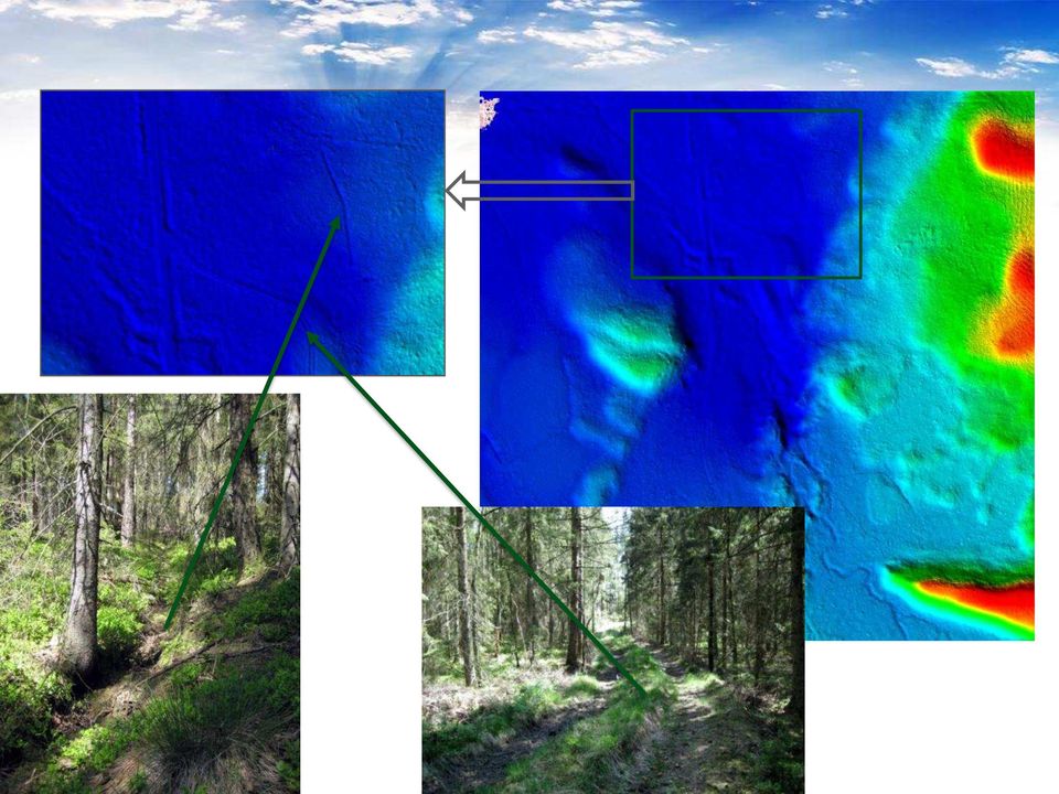
7
8 Identification of single trees Single trees are detected by analysis of surface model and point data Ref. Persson, Å., Holmgren, J. & Söderman, U. 2002: Detecting and measuring individual trees using an airborne laser scanner, Photogrammetric Engineering & Remote Sensing, Vol. 68, No. 9, Sept. Persson Å., Holmgren J., and Söderman U Detection, measurements, and species classification of individual trees for forest inventory and visualisation, in Proceeding of the ScandLaser Scientific Workshop on Airborne Laser Scanning of Forests, ISSN , Umeå, Sweden.

9 Tree species classification For each tree the laser point distribution is analyzed. The result is used for a first classification of tree specie (pine, spruce, broadleaf) Local field data is used to train the classifier Källa: FOI
 Local field data is used")
10 Tree species classification The quality of the tree species classification can be increased if spectral information from images are used together with laser data. Different broadleaves species can be classified using hyperspectral image data Local field data is used to train the classifier Pine Spruce Deciduous Ref. Holmgren, J., Persson, Å., and Söderman, U Species identification of individual trees by combining high resolution LiDAR data with multi-spectral images, in Special issue of International Journal of Remote Sensing - 3D Remote Sensing in Forestry, Volume 29, Issue 5, March, Pages

11 Airborne LIDAR and hyperspectral data Customer SingleTree data Local field data


12 FORAN Forest Inventory Different types of layers SingleTree ForestGrid Resource inventory Aggregated stands

13 Other forestry applications 3D visualizations of forest areas Forest vitality index Improved management planning - Climate change adaptation - Ecological landscape approach - Communication

14 Evaluations performed by Swedish Forest Industry Research Institute SKOGFORSK FORAN SingleTree describes the forest with higher acuracy than those field-based methods that are traditionally used for forest operational planning. As a whole, the conclusion is that FORAN SingleTree delivers improved tree and forest inventory data if compeered with traditional data collection methods for operational planning.

15 Thank you for your attention!

Nature Values Screening Using Object-Based Image Analysis of Very High Resolution Remote Sensing Data
 Nature Values Screening Using Object-Based Image Analysis of Very High Resolution Remote Sensing Data Aleksi Räsänen*, Anssi Lensu, Markku Kuitunen Environmental Science and Technology Dept. of Biological
REGISTRATION OF LASER SCANNING POINT CLOUDS AND AERIAL IMAGES USING EITHER ARTIFICIAL OR NATURAL TIE FEATURES
 REGISTRATION OF LASER SCANNING POINT CLOUDS AND AERIAL IMAGES USING EITHER ARTIFICIAL OR NATURAL TIE FEATURES P. Rönnholm a, *, H. Haggrén a a Aalto University School of Engineering, Department of Real
National Inventory of Landscapes in Sweden
 Key messages Approaching the landscape perspective in monitoring experiences in the Swedish NILS program Johan Svensson, Future Forest Monitoring, 091112 Landscape level approaches are necessary to deal
Geospatial Software Solutions for the Environment and Natural Resources
 Geospatial Software Solutions for the Environment and Natural Resources Manage and Preserve the Environment and its Natural Resources Our environment and the natural resources it provides play a growing
LiDAR remote sensing to individual tree processing: A comparison between high and low pulse density in Florida, United States of America
 LiDAR remote sensing to individual tree processing: A comparison between high and low pulse density in Florida, United States of America Carlos Alberto Silva 1 Andrew Hudak 2 Robert Liebermann 2 Kevin
MOVING FORWARD WITH LIDAR REMOTE SENSING: AIRBORNE ASSESSMENT OF FOREST CANOPY PARAMETERS
 MOVING FORWARD WITH LIDAR REMOTE SENSING: AIRBORNE ASSESSMENT OF FOREST CANOPY PARAMETERS Alicia M. Rutledge Sorin C. Popescu Spatial Sciences Laboratory Department of Forest Science Texas A&M University
 European Forest Data Centre Biosoil/Biodiversity Forest Type Map 2006 P. Kempeneers, JRC T. Durant F. Sedano, JRC L. Seebach, JRC J. San-Miguel-Ayanz, JRC EC -, IES Land Management and Natural Hazard Unit
Global environmental information Examples of EIS Data sets and applications
 METIER Graduate Training Course n 2 Montpellier - february 2007 Information Management in Environmental Sciences Global environmental information Examples of EIS Data sets and applications Global datasets
ANALYSIS OF FOREST CHANGE IN FIRE DAMAGE AREA USING SATELLITE IMAGES
 ANALYSIS OF FOREST CHANGE IN FIRE DAMAGE AREA USING SATELLITE IMAGES Joon Mook Kang, Professor Joon Kyu Park, Ph.D Min Gyu Kim, Ph.D._Candidate Dept of Civil Engineering, Chungnam National University 220
FOREST PARAMETER ESTIMATION BY LIDAR DATA PROCESSING
 P.-F. Mursa Forest parameter estimation by LIDAR data processing FOREST PARAMETER ESTIMATION BY LIDAR DATA PROCESSING Paula-Florina MURSA, Master Student Military Technical Academy, [email protected]
.FOR. Forest inventory and monitoring quality
 .FOR Forest inventory and monitoring quality FOR : the asset to manage your forest patrimony 2 1..FOR Presentation.FOR is an association of Belgian companies, created in 2010 and supported by a university
Lidar Remote Sensing for Forestry Applications
 Lidar Remote Sensing for Forestry Applications Ralph O. Dubayah* and Jason B. Drake** Department of Geography, University of Maryland, College Park, MD 0 *[email protected] **[email protected] 1
MAPPING MINNEAPOLIS URBAN TREE CANOPY. Why is Tree Canopy Important? Project Background. Mapping Minneapolis Urban Tree Canopy.
 MAPPING MINNEAPOLIS URBAN TREE CANOPY Why is Tree Canopy Important? Trees are an important component of urban environments. In addition to their aesthetic value, trees have significant economic and environmental
RESOLUTION MERGE OF 1:35.000 SCALE AERIAL PHOTOGRAPHS WITH LANDSAT 7 ETM IMAGERY
 RESOLUTION MERGE OF 1:35.000 SCALE AERIAL PHOTOGRAPHS WITH LANDSAT 7 ETM IMAGERY M. Erdogan, H.H. Maras, A. Yilmaz, Ö.T. Özerbil General Command of Mapping 06100 Dikimevi, Ankara, TURKEY - (mustafa.erdogan;
Chapter Contents Page No
 Chapter Contents Page No Preface Acknowledgement 1 Basics of Remote Sensing 1 1.1. Introduction 1 1.2. Definition of Remote Sensing 1 1.3. Principles of Remote Sensing 1 1.4. Various Stages in Remote Sensing
Methods for Monitoring Forest and Land Cover Changes and Unchanged Areas from Long Time Series
 Methods for Monitoring Forest and Land Cover Changes and Unchanged Areas from Long Time Series Project using historical satellite data from SACCESS (Swedish National Satellite Data Archive) for developing
CARBON BALANCE IN BIOMASS OF MAIN FOREST TREE SPECIES IN POLAND
 CARBON BALANCE IN BIOMASS OF MAIN FOREST TREE SPECIES IN POLAND PAWEŁ STRZELIŃSKI Department of Forest Management Poznan University of Life Science TOMASZ ZAWIŁA-NIEDŹWIECKI Forest Research Institute in
DATA MINING SPECIES DISTRIBUTION AND LANDCOVER. Dawn Magness Kenai National Wildife Refuge
 DATA MINING SPECIES DISTRIBUTION AND LANDCOVER Dawn Magness Kenai National Wildife Refuge Why Data Mining Random Forest Algorithm Examples from the Kenai Species Distribution Model Pattern Landcover Model
AN INVESTIGATION OF THE GROWTH TYPES OF VEGETATION IN THE BÜKK MOUNTAINS BY THE COMPARISON OF DIGITAL SURFACE MODELS Z. ZBORAY AND E.
 ACTA CLIMATOLOGICA ET CHOROLOGICA Universitatis Szegediensis, Tom. 38-39, 2005, 163-169. AN INVESTIGATION OF THE GROWTH TYPES OF VEGETATION IN THE BÜKK MOUNTAINS BY THE COMPARISON OF DIGITAL SURFACE MODELS
CROP CLASSIFICATION WITH HYPERSPECTRAL DATA OF THE HYMAP SENSOR USING DIFFERENT FEATURE EXTRACTION TECHNIQUES
 Proceedings of the 2 nd Workshop of the EARSeL SIG on Land Use and Land Cover CROP CLASSIFICATION WITH HYPERSPECTRAL DATA OF THE HYMAP SENSOR USING DIFFERENT FEATURE EXTRACTION TECHNIQUES Sebastian Mader
The premier software for extracting information from geospatial imagery.
 Imagery Becomes Knowledge ENVI The premier software for extracting information from geospatial imagery. ENVI Imagery Becomes Knowledge Geospatial imagery is used more and more across industries because
Digital Remote Sensing Data Processing Digital Remote Sensing Data Processing and Analysis: An Introduction and Analysis: An Introduction
 Digital Remote Sensing Data Processing Digital Remote Sensing Data Processing and Analysis: An Introduction and Analysis: An Introduction Content Remote sensing data Spatial, spectral, radiometric and
Transatlantic Masters Degree Program in Forest Resources (ATLANTIS)
") Faculty of Agriculture and Festry Transatlantic Masters Degree Program in Fest Resources (ATLANTIS) University of Helsinki, Department of Fest Sciences Transatlantic Masters Degree Program in Fest Resources
Faculty of Agriculture and Festry Transatlantic Masters Degree Program in Fest Resources (ATLANTIS) University of Helsinki, Department of Fest Sciences Transatlantic Masters Degree Program in Fest Resources
2002 URBAN FOREST CANOPY & LAND USE IN PORTLAND S HOLLYWOOD DISTRICT. Final Report. Michael Lackner, B.A. Geography, 2003
 2002 URBAN FOREST CANOPY & LAND USE IN PORTLAND S HOLLYWOOD DISTRICT Final Report by Michael Lackner, B.A. Geography, 2003 February 2004 - page 1 of 17 - TABLE OF CONTENTS Abstract 3 Introduction 4 Study
Review for Introduction to Remote Sensing: Science Concepts and Technology
 Review for Introduction to Remote Sensing: Science Concepts and Technology Ann Johnson Associate Director [email protected] Funded by National Science Foundation Advanced Technological Education program [DUE
ESTIMATION OF TIMBER ASSORTMENTS USING LOW-DENSITY ALS DATA
 In: Wagner W., Székely, B. (eds.): ISPRS TC VII Symposium 0 Years ISPRS, Vienna, Austria, July 5 7,, IAPRS, Vol. XXXVIII, Part 7A ESTIMATION OF TIMBER ASSORTMENTS USING LOW-DENSITY ALS DATA M. Holopainen
Outline - needs of land cover - global land cover projects - GLI land cover product. legend. Cooperation with Global Mapping project
 Land Cover Mapping by GLI data Ryutaro Tateishi Center for Environmental Remote Sensing (CEReS) Chiba University E-mail: [email protected] Outline - needs of land cover - global land cover
ENVIRONMENTAL MONITORING Vol. I - Remote Sensing (Satellite) System Technologies - Michael A. Okoye and Greg T. Koeln
 System Technologies - Michael A. Okoye and Greg T. Koeln") REMOTE SENSING (SATELLITE) SYSTEM TECHNOLOGIES Michael A. Okoye and Greg T. Earth Satellite Corporation, Rockville Maryland, USA Keywords: active microwave, advantages of satellite remote sensing, atmospheric
REMOTE SENSING (SATELLITE) SYSTEM TECHNOLOGIES Michael A. Okoye and Greg T. Earth Satellite Corporation, Rockville Maryland, USA Keywords: active microwave, advantages of satellite remote sensing, atmospheric
High Resolution RF Analysis: The Benefits of Lidar Terrain & Clutter Datasets
 0 High Resolution RF Analysis: The Benefits of Lidar Terrain & Clutter Datasets January 15, 2014 Martin Rais 1 High Resolution Terrain & Clutter Datasets: Why Lidar? There are myriad methods, techniques
Transatlantic Masters Degree Program in Forest Resources (ATLANTIS)
") Faculty of Agriculture and Festry Transatlantic Masters Degree Program in Fest Resources (ATLANTIS) University of Helsinki, Department of Fest Sciences Transatlantic Masters Degree Program in Fest Resources
Faculty of Agriculture and Festry Transatlantic Masters Degree Program in Fest Resources (ATLANTIS) University of Helsinki, Department of Fest Sciences Transatlantic Masters Degree Program in Fest Resources
3D Point Cloud Analytics for Updating 3D City Models
 3D Point Cloud Analytics for Updating 3D City Models Rico Richter 25 th May 2015 INSPIRE - Geospatial World Forum 2015 Background Hasso Plattner Institute (HPI): Computer Graphics Systems group of Prof.
Contributions of the geospatial fields to monitoring sustainability of urban environments John Trinder. School of Civil and Environmental Engineering
 Contributions of the geospatial fields to monitoring sustainability of urban environments John Trinder School of Civil and Environmental Engineering 2 IMPACT OF HUMAN DEVELOPMENT Humans are modifying the
GIS Data Quality and Evaluation. Tomislav Sapic GIS Technologist Faculty of Natural Resources Management Lakehead University
 GIS Data Quality and Evaluation Tomislav Sapic GIS Technologist Faculty of Natural Resources Management Lakehead University The quality of GIS data gains in importance when considering some of the main
The following was presented at DMT 14 (June 1-4, 2014, Newark, DE).
.") DMT 2014 The following was presented at DMT 14 (June 1-4, 2014, Newark, DE). The contents are provisional and will be superseded by a paper in the DMT 14 Proceedings. See also presentations and Proceedings
DMT 2014 The following was presented at DMT 14 (June 1-4, 2014, Newark, DE). The contents are provisional and will be superseded by a paper in the DMT 14 Proceedings. See also presentations and Proceedings
The YellowScan system: A test on the oppida of Nages/Roque de Viou (Languedoc, France) Tristan Allouis, PhD Research and Development, L'Avion Jaune
 Tristan Allouis, PhD Research and Development, L'Avion Jaune") The YellowScan system: A test on the oppida of Nages/Roque de Viou (Languedoc, France) Tristan Allouis, PhD Research and Development, L'Avion Jaune L'Avion Jaune : Earth observation data provider UAVs
The YellowScan system: A test on the oppida of Nages/Roque de Viou (Languedoc, France) Tristan Allouis, PhD Research and Development, L'Avion Jaune L'Avion Jaune : Earth observation data provider UAVs
ASSESSING EFFECTS OF LASER POINT DENSITY ON BIOPHYSICAL STAND PROPERTIES DERIVED FROM AIRBORNE LASER SCANNER DATA IN MATURE FOREST
 ISPRS Workshop on Laser Scanning 2007 and SilviLaser 2007, Espoo, September 12-14, 2007, Finland ASSESSING EFFECTS OF LASER POINT DENSITY ON BIOPHYSICAL STAND PROPERTIES DERIVED FROM AIRBORNE LASER SCANNER
Active and Passive Microwave Remote Sensing
 Active and Passive Microwave Remote Sensing Passive remote sensing system record EMR that was reflected (e.g., blue, green, red, and near IR) or emitted (e.g., thermal IR) from the surface of the Earth.
Earth Data Science in The Era of Big Data and Compute
 Earth Data Science in The Era of Big Data and Compute E. Lynn Usery U.S. Geological Survey [email protected] http://cegis.usgs.gov U.S. Department of the Interior U.S. Geological Survey Board on Earth Sciences
Nationwide forest estimates in Sweden using satellite data and airborne LiDAR. (Or: going from 2 D to 3D)
") Nationwide forest estimates in Sweden using satellite data and airborne LiDAR (Or: going from 2 D to 3D) Håkan Olsson Mats Nilsson, Johan Fransson, Henrik Persson and Mikael Egberth (SLU) Umeå Svante Larsson
Nationwide forest estimates in Sweden using satellite data and airborne LiDAR (Or: going from 2 D to 3D) Håkan Olsson Mats Nilsson, Johan Fransson, Henrik Persson and Mikael Egberth (SLU) Umeå Svante Larsson
Cost Considerations of Using LiDAR for Timber Inventory 1
 Cost Considerations of Using LiDAR for Timber Inventory 1 Bart K. Tilley, Ian A. Munn 3, David L. Evans 4, Robert C. Parker 5, and Scott D. Roberts 6 Acknowledgements: Mississippi State University College
MPHIL in GEOGRAPHICAL INFORMATION SYSTEMS AND REMOTE SENSING
 University of Cambridge: Programme Specifications Every effort has been made to ensure the accuracy of the information contained in this programme specification. At the time of publication, the programme
LiDAR for vegetation applications
 LiDAR for vegetation applications UoL MSc Remote Sensing Dr Lewis [email protected] Introduction Introduction to LiDAR RS for vegetation Review instruments and observational concepts Discuss applications
IMPERVIOUS SURFACE MAPPING UTILIZING HIGH RESOLUTION IMAGERIES. Authors: B. Acharya, K. Pomper, B. Gyawali, K. Bhattarai, T.
 IMPERVIOUS SURFACE MAPPING UTILIZING HIGH RESOLUTION IMAGERIES Authors: B. Acharya, K. Pomper, B. Gyawali, K. Bhattarai, T. Tsegaye ABSTRACT Accurate mapping of artificial or natural impervious surfaces
Let s SAR: Mapping and monitoring of land cover change with ALOS/ALOS-2 L-band data
 Let s SAR: Mapping and monitoring of land cover change with ALOS/ALOS-2 L-band data Rajesh Bahadur THAPA, Masanobu SHIMADA, Takeshi MOTOHKA, Manabu WATANABE and Shinichi [email protected]; [email protected]
CLIMATE CHANGE & FORESTS; STATUS OF SCIENCE, POLICY & RESEARCH. Prof. Ravindranath Indian Institute of Science Bangalore
 CLIMATE CHANGE & FORESTS; STATUS OF SCIENCE, POLICY & RESEARCH Prof. Ravindranath Indian Institute of Science Bangalore Forests and climate change 1. Deforestation and land use change contribute to CO
MINNESOTA DEPARTMENT OF NATURAL RESOURCES. Division of Forestry
 MINNESOTA DEPARTMENT OF NATURAL RESOURCES Division of Forestry Other major programs: Private Forest Management Urban and Community Forestry Insect and Disease Management Urban and Community Forestry
Hydrographic Surveying using High Resolution Satellite Images
 Hydrographic Surveying using High Resolution Satellite Images Petra PHILIPSON and Frida ANDERSSON, Sweden Key words: remote sensing, high resolution, hydrographic survey, depth estimation. SUMMARY The
AN INTEGRATED WORKFLOW FOR LIDAR / OPTICAL DATA MAPPING FOR SECURITY APPLICATIONS
 AN INTEGRATED WORKFLOW FOR LIDAR / OPTICAL DATA MAPPING FOR SECURITY APPLICATIONS Dirk Tiede, Thomas Blaschke Z_GIS; Centre for GeoInformatics, University of Salzburg, Hellbrunnerstrasse 34, 5020 Salzburg,
ENVI THE PREMIER SOFTWARE FOR EXTRACTING INFORMATION FROM GEOSPATIAL IMAGERY.
 ENVI THE PREMIER SOFTWARE FOR EXTRACTING INFORMATION FROM GEOSPATIAL IMAGERY. ENVI Imagery Becomes Knowledge ENVI software uses proven scientific methods and automated processes to help you turn geospatial
Accelerated Master of Geographic Information Science. School of Forest Resources and Environmental Science
 Accelerated Master of Geographic Information Science School of Forest Resources and Environmental Science Contacts: Andrew J. Storer, Associate Dean Michael D. Hyslop, MGIS Coordinator Overview The accelerated
An Assessment of the Effectiveness of Segmentation Methods on Classification Performance
 An Assessment of the Effectiveness of Segmentation Methods on Classification Performance Merve Yildiz 1, Taskin Kavzoglu 2, Ismail Colkesen 3, Emrehan K. Sahin Gebze Institute of Technology, Department
Curriculum and Module Description International Master Study Programme Forest Information Technology (M.Sc.) (effective from WS 2009/10)
 (effective from WS 2009/10)") Curriculum and Module Description International Master Study Programme Forest Information Technology (M.Sc.) (effective from WS 2009/10) Semester Status Module Component Module SWH Form Language Exam Form
Curriculum and Module Description International Master Study Programme Forest Information Technology (M.Sc.) (effective from WS 2009/10) Semester Status Module Component Module SWH Form Language Exam Form
Data Management Framework for the North American Carbon Program
 Data Management Framework for the North American Carbon Program Bob Cook, Peter Thornton, and the Steering Committee Image courtesy of NASA/GSFC NACP Data Management Planning Workshop New Orleans, LA January
Hyperspectral Satellite Imaging Planning a Mission
 Hyperspectral Satellite Imaging Planning a Mission Victor Gardner University of Maryland 2007 AIAA Region 1 Mid-Atlantic Student Conference National Institute of Aerospace, Langley, VA Outline Objective
Research On The Classification Of High Resolution Image Based On Object-oriented And Class Rule
 Research On The Classification Of High Resolution Image Based On Object-oriented And Class Rule Li Chaokui a,b, Fang Wen a,b, Dong Xiaojiao a,b a National-Local Joint Engineering Laboratory of Geo-Spatial
Review of the Availability and Accuracy. of Information about Forests: Phase I Report
 Review of the Availability and Accuracy of Information about Forests: Phase I Report Prepared by Minnesota Forest Resources Council Forest Resource Information Management Committee In partnership with
Environmental Remote Sensing GEOG 2021
 Environmental Remote Sensing GEOG 2021 Lecture 4 Image classification 2 Purpose categorising data data abstraction / simplification data interpretation mapping for land cover mapping use land cover class
Radiological characterisation by means of 3D-laser modelling and positioning of measurements
 Radiological characterisation by means of 3D-laser modelling and positioning of measurements Robert Hedvall 1, Patrik Johansson 1, Peter Erixon 1, Fredrik Ekenborg 1, Feng Quanhong 2 and PA Andersson 3
Forest Inventory Strategic Plan
 February 2013 Ministry of Forests, Lands and Natural Resource Operations Forest Inventory Strategic Plan The forest inventory program outlined in this strategic plan will help the Ministry of Forests,
GEO-SPATIAL-TECHNOLOGIES", a trans-university new integrative master degree
 GEO-SPATIAL-TECHNOLOGIES", a trans-university new integrative master degree Wolfgang Sulzer Institute for Geography and Regional Science University of Graz, Austria Heinrichstrasse 36 A-8010 Graz, Austria
Field Techniques Manual: GIS, GPS and Remote Sensing
 Field Techniques Manual: GIS, GPS and Remote Sensing Section A: Introduction Chapter 1: GIS, GPS, Remote Sensing and Fieldwork 1 GIS, GPS, Remote Sensing and Fieldwork The widespread use of computers
Key words: Laser Scanning, LIDAR, Surveying and Mapping, Point Cloud, Geospatial software
 Volume 5, Issue 5, May 2015 ISSN: 2277 128X International Journal of Advanced Research in Computer Science and Software Engineering Research Paper Available online at: www.ijarcsse.com Comparative Study
Multi-scale upscaling approaches of soil properties from soil monitoring data
 local scale landscape scale forest stand/ site level (management unit) Multi-scale upscaling approaches of soil properties from soil monitoring data sampling plot level Motivation: The Need for Regionalization
3D Building Roof Extraction From LiDAR Data
 3D Building Roof Extraction From LiDAR Data Amit A. Kokje Susan Jones NSG- NZ Outline LiDAR: Basics LiDAR Feature Extraction (Features and Limitations) LiDAR Roof extraction (Workflow, parameters, results)
SEMANTIC LABELLING OF URBAN POINT CLOUD DATA
 SEMANTIC LABELLING OF URBAN POINT CLOUD DATA A.M.Ramiya a, Rama Rao Nidamanuri a, R Krishnan a Dept. of Earth and Space Science, Indian Institute of Space Science and Technology, Thiruvananthapuram,Kerala
Forestry Thematic Exploitation Platform Earth Observation Open Science 2.0
 Forestry Thematic Exploitation Platform Earth Observation Open Science 2.0 Tuomas Häme VTT Technical Research of Finland Ltd and the Forestry TEP Team Objective One-stop shop for forestry remote sensing
Understanding Raster Data
 Introduction The following document is intended to provide a basic understanding of raster data. Raster data layers (commonly referred to as grids) are the essential data layers used in all tools developed
Possibilities of applying CORONA archive satellite images in forest cover change detection example of the Fruška Gora mountain
 ISSN 0354-8724 (hard copy) ISSN 1820-7138 (online) Possibilities of applying CORONA archive satellite images in forest cover change detection example of the Fruška Gora mountain Minucsér Mészáros A *,
The Use of Geographic Information Systems in Risk Assessment
 The Use of Geographic Information Systems in Risk Assessment With Specific Focus on the RiVAMP Methodology Presented by Nadine Brown August 27, 2012 Climate Studies Group Mona Climate Change Workshop Presentation
VCS REDD Methodology Module. Methods for monitoring forest cover changes in REDD project activities
 1 VCS REDD Methodology Module Methods for monitoring forest cover changes in REDD project activities Version 1.0 May 2009 I. SCOPE, APPLICABILITY, DATA REQUIREMENT AND OUTPUT PARAMETERS Scope This module
Evaluation of surface runoff conditions. scanner in an intensive apple orchard
 Evaluation of surface runoff conditions by high resolution terrestrial laser scanner in an intensive apple orchard János Tamás 1, Péter Riczu 1, Attila Nagy 1, Éva Lehoczky 2 1 Faculty of Agricultural
Bachelor of Geospatial Science Inaugural intake 2015
 Bachelor of Geospatial Science Inaugural intake 2015 Aleen Prasad and Dr Nick Rollings Geospatial Science Unit School of Geography, Earth Science and Environment The University of the South Pacific Geospatial
Mobilising Vegetation Plot Data: the National Vegetation Survey Databank. Susan Wiser April 2016 http://nvs.landcareresearch.co.nz
 Mobilising Vegetation Plot Data: the National Vegetation Survey Databank Susan Wiser April 2016 http://nvs.landcareresearch.co.nz Nationally Significant Databases and Collections http://natsigdc.landcareresearch.co.nz/natsigdc_list.html
Remote Sensing in Natural Resources Mapping
 Remote Sensing in Natural Resources Mapping NRS 516, Spring 2016 Overview of Remote Sensing in Natural Resources Mapping What is remote sensing? Why remote sensing? Examples of remote sensing in natural
Available study programs at Czech University of Life Sciences Prague
 EU subject code University subject Name of course/program Mobility Language Homepage 1,1 1,1 Environmental Engineering in Agriculture II Rural Communication and Extension 1,1 Tropical Forestry and Agroforestry
Objectives. Raster Data Discrete Classes. Spatial Information in Natural Resources FANR 3800. Review the raster data model
 Spatial Information in Natural Resources FANR 3800 Raster Analysis Objectives Review the raster data model Understand how raster analysis fundamentally differs from vector analysis Become familiar with
Effect of Alternative Splitting Rules on Image Processing Using Classification Tree Analysis
 Effect of Alternative Splitting Rules on Image Processing Using Classification Tree Analysis Michael Zambon, Rick Lawrence, Andrew Bunn, and Scott Powell Abstract Rule-based classification using classification
MULTIPURPOSE USE OF ORTHOPHOTO MAPS FORMING BASIS TO DIGITAL CADASTRE DATA AND THE VISION OF THE GENERAL DIRECTORATE OF LAND REGISTRY AND CADASTRE
 MULTIPURPOSE USE OF ORTHOPHOTO MAPS FORMING BASIS TO DIGITAL CADASTRE DATA AND THE VISION OF THE GENERAL DIRECTORATE OF LAND REGISTRY AND CADASTRE E.ÖZER, H.TUNA, F.Ç.ACAR, B.ERKEK, S.BAKICI General Directorate
Remote Sensing and GIS Application In Change Detection Study In Urban Zone Using Multi Temporal Satellite
 Remote Sensing and GIS Application In Change Detection Study In Urban Zone Using Multi Temporal Satellite R.Manonmani, G.Mary Divya Suganya Institute of Remote Sensing, Anna University, Chennai 600 025
Analysis of Land Use/Land Cover Change in Jammu District Using Geospatial Techniques
 Analysis of Land Use/Land Cover Change in Jammu District Using Geospatial Techniques Dr. Anuradha Sharma 1, Davinder Singh 2 1 Head, Department of Geography, University of Jammu, Jammu-180006, India 2
JRC on 9 November 2009 Biosoil Conference 1. http://forest.jrc.ec.europa.eu/
 JRC on 9 November 2009 Biosoil Conference 1 The European Forest Data Centre (EFDAC) Jesús San-Miguel-Ayanz http://forest.jrc.ec.europa.eu/ Outline FOREST Action 2 1. Role of the European Commission Joint
A new SPOT4-VEGETATION derived land cover map of Northern Eurasia
 INT. J. REMOTE SENSING, 2003, VOL. 24, NO. 9, 1977 1982 A new SPOT4-VEGETATION derived land cover map of Northern Eurasia S. A. BARTALEV, A. S. BELWARD Institute for Environment and Sustainability, EC
ASSESSMENT OF FOREST RECOVERY AFTER FIRE USING LANDSAT TM IMAGES AND GIS TECHNIQUES: A CASE STUDY OF MAE WONG NATIONAL PARK, THAILAND
 ASSESSMENT OF FOREST RECOVERY AFTER FIRE USING LANDSAT TM IMAGES AND GIS TECHNIQUES: A CASE STUDY OF MAE WONG NATIONAL PARK, THAILAND Sunee Sriboonpong 1 Yousif Ali Hussin 2 Alfred de Gier 2 1 Forest Resource