JACIE Science Applications of High Resolution Imagery at the USGS EROS Data Center
|
|
|
- Kelly Morgan
- 8 years ago
- Views:
Transcription
1 JACIE Science Applications of High Resolution Imagery at the USGS EROS Data Center November 8-10, 2004 U.S. Department of the Interior U.S. Geological Survey Michael Coan, SAIC USGS EROS Data Center

2 USGS EROS Data Center Science Directorate is composed of many High-Resolution users- Land Cover Trends Project uses NHAP and NAPP (1:40K, 1:20K) along with DOQQs to interperet Landsat imagery, aiding in classifications Native American Project uses aerial photo products for forest inventory, new road and structure locations, range management, prairie dog town delineations (annual basis) Amphibian Habitat Project uses DOQQs to supplement fieldwork, to verify locations, identify potential habitat, verify models, and help interpret Landsat imagery National Land Cover Project uses all available sources (aerial photos, DOQQs, IKONOS, QuickBird, etc.) for computations of nation-wide percent-impervious surface and percent tree canopy estimation layers.

3 USGS EROS Data Center (more users)- LandFire Project is investigating methods developed by NLCD for computing shrub coverage and structure in Western US. International Program s Sahel Project uses 5m Spot panchromatic, 1m color photomosaics, and 1960 s era Corona film (pan, ~2 to 3m) in Senegal for community based forest management. The forty year span helps determine how much was lost or protected, as well as the amount of soil erosion, and the condition and density of the trees. Disaster Response Task Group works with FEMA, NASA, USGS, NOAA, ACE and other Federal, State, and local agencies. They use a variety of imagery, depending on type of disaster, the extent of damage, location, availability, and price. Currently there is no coordinated effort to collect consistent event based coverages for archives.

4 NLCD/LandFire - Sagebrush Research Example Western US contains large areas of sagebrush steppe Critical habitat for sage grouse Pilot area in Western Dakotas, Eastern Wyoming and Montana Sagebrush Prediction Study Area

5 Sagebrush QuickBird Pan-sharpened Multispectral Data Training data developed on 3 QuickBird scenes Pan-sharpened multispectral data allows sagebrush shrub clusters to be identified.

6 Sagebrush - Classifying at high resolution Supervised classification of imagery into sagebrush/not sagebrush (on right, sagebrush is yellow) Note- Could possibly be extended to herbaceous and barren classifications, too.

7 Sagebrush Estimate Percentage at 30m resolution Classified high-resolution image is rescaled to 30m, to match the Landsat imagery. Values are determined by counting numbers of individual sagebrush-classified pixels in higher resolution in a 900m^2 neighborhood, and averaging those values for each 30m pixel. LandSat (30m) %Sage Estimation (30m)

8 Sagebrush Estimation Output at Landsat Image Scale Estimations applied to one Landsat scene (~110 mi^2) Pink to red are variations in sagebrush density (darker is more). Three yellow chips are the original QuickBird training areas.
.")
 Orbview image")
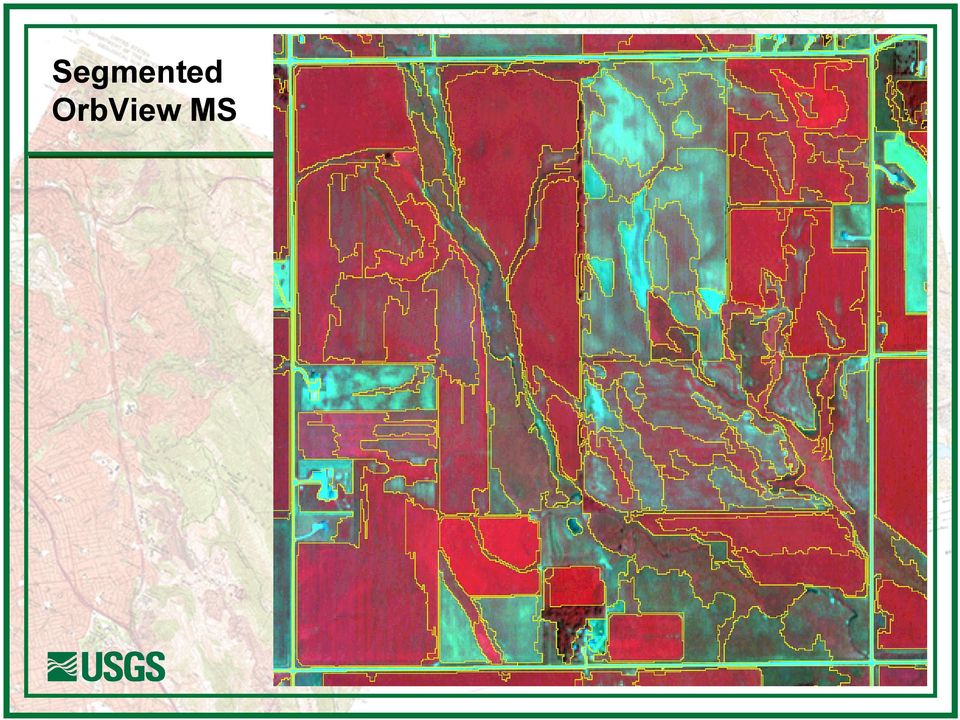
9 Comparison of 4m OrbView Multispectral to 30m Landsat Segmented OrbView product displays obvious potential for riparian zone delineation, wildlife habitat characterization, soil type differentiation, cropland quality assessment, environmental monitoring, Landsat image (8/9/2000) Orbview image (7/27/2004)
 Orbview image")
10 Segmented OrbView MS
11 Topographic Program Perennial/Intermittent Stream Classification Study Regulations to protect water quality often depend on perennial and intermittent stream classifications shown on the USGS 1:24,000 (7.5 arc minute series) Quadrangle maps. Individual quadrangle maps may contain inconsistent stream classifications, or stream densities, from one quadrangle to another. The purpose of the Topographic Program s study is to predict where perennial and intermittent streams will occur. A consistent stream density is required for input to the modeling process. In this study, an OrbView 4m Multispectral image contributed to visual verification of a stream density modeling procedure.


12 Topographic Program Study Area The study area is in a portion of the West Pipestone Creek Watershed, in Eastern South Dakota. This area was imaged by an OrbView MS product in July, West Pipestone Creek Watershed South Dakota Iowa

13 Topographic Program Manually Digitized Streamlines Manually digitized 1:24,000 USGS stream lines shown in yellow, watershed boundary in black.

14 Topographic Program Synthetic Streams Synthetic flow lines, generated from a 10meter Digital Elevation Model, are shown in green. One of the settings used to generate synthetic streams is a basin threshold. Here, a basin threshold of 2500 pixels was used.

15 Topographic Program Varying the Stream Density Model output with flow-accumulation set to 20 pixels. Resulting synthetic flow lines were too dense for this particular application.

16 Topographic Program Another Stream Density Here a threshold of 250 pixels was used. The OrbView image helped validate that the synthetic streams were generated at a more appropriate density

17 USGS Science Links- Land Cover Trends: Amphibian Habitat: National Land Cover: Fire Science: International Program, Sahel Land Use: Topographic Research (Perennial/Intermittent/Ephemeral): Perennial_intermittent_ephemeral.pdf Disaster Response:

AERIAL PHOTOGRAPHS. For a map of this information, in paper or digital format, contact the Tompkins County Planning Department.
 AERIAL PHOTOGRAPHS What are Aerial Photographs? Aerial photographs are images of the land taken from an airplane and printed on 9 x9 photographic paper. Why are Aerial Photographs Important? Aerial photographs
Spectral Response for DigitalGlobe Earth Imaging Instruments
 Spectral Response for DigitalGlobe Earth Imaging Instruments IKONOS The IKONOS satellite carries a high resolution panchromatic band covering most of the silicon response and four lower resolution spectral
Earth Data Science in The Era of Big Data and Compute
 Earth Data Science in The Era of Big Data and Compute E. Lynn Usery U.S. Geological Survey usery@usgs.gov http://cegis.usgs.gov U.S. Department of the Interior U.S. Geological Survey Board on Earth Sciences
EcoInformatics International Inc.
 1 von 10 03.08.2010 14:25 EcoInformatics International Inc. Home Services - solutions Projects Concepts Tools Links Contact EXPLORING BEAVER HABITAT AND DISTRIBUTION WITH GOOGLE EARTH: THE LONGEST BEAVER
Assessing Hurricane Katrina Damage to the Mississippi Gulf Coast Using IKONOS Imagery
 Assessing Hurricane Katrina Damage to the Mississippi Gulf Coast Using IKONOS Imagery Joseph P. Spruce Science Systems and Applications, Inc. John C., MS 39529 Rodney McKellip NASA Project Integration
Information Contents of High Resolution Satellite Images
 Information Contents of High Resolution Satellite Images H. Topan, G. Büyüksalih Zonguldak Karelmas University K. Jacobsen University of Hannover, Germany Keywords: satellite images, mapping, resolution,
Nature Values Screening Using Object-Based Image Analysis of Very High Resolution Remote Sensing Data
 Nature Values Screening Using Object-Based Image Analysis of Very High Resolution Remote Sensing Data Aleksi Räsänen*, Anssi Lensu, Markku Kuitunen Environmental Science and Technology Dept. of Biological
Review for Introduction to Remote Sensing: Science Concepts and Technology
 Review for Introduction to Remote Sensing: Science Concepts and Technology Ann Johnson Associate Director ann@baremt.com Funded by National Science Foundation Advanced Technological Education program [DUE
2002 URBAN FOREST CANOPY & LAND USE IN PORTLAND S HOLLYWOOD DISTRICT. Final Report. Michael Lackner, B.A. Geography, 2003
 2002 URBAN FOREST CANOPY & LAND USE IN PORTLAND S HOLLYWOOD DISTRICT Final Report by Michael Lackner, B.A. Geography, 2003 February 2004 - page 1 of 17 - TABLE OF CONTENTS Abstract 3 Introduction 4 Study
Land-Cover and Imperviousness Data for Regional Areas near Denver, Colorado; Dallas- Fort Worth, Texas; and Milwaukee-Green Bay, Wisconsin - 2001
 U.S. Geological Survey Data Series Land-Cover and Imperviousness Data for Regional Areas near Denver, Colorado; Dallas- Fort Worth, Texas; and Milwaukee-Green Bay, Wisconsin - 2001 By James Falcone and
OBJECT BASED IMAGE CLASSIFICATION AND WEB-MAPPING TECHNIQUES FOR FLOOD DAMAGE ASSESSMENT
 OBJECT BASED IMAGE CLASSIFICATION AND WEB-MAPPING TECHNIQUES FOR FLOOD DAMAGE ASSESSMENT Ejaz Hussain, KyoHyouk Kim, Jie Shan {ehussain, kim458, jshan}@ecn.purdue.edu Geomatics Engineering, School of Civil
Digital image processing
 746A27 Remote Sensing and GIS Lecture 4 Digital image processing Chandan Roy Guest Lecturer Department of Computer and Information Science Linköping University Digital Image Processing Most of the common
APPLICATION OF MULTITEMPORAL LANDSAT DATA TO MAP AND MONITOR LAND COVER AND LAND USE CHANGE IN THE CHESAPEAKE BAY WATERSHED
 APPLICATION OF MULTITEMPORAL LANDSAT DATA TO MAP AND MONITOR LAND COVER AND LAND USE CHANGE IN THE CHESAPEAKE BAY WATERSHED S. J. GOETZ Woods Hole Research Center Woods Hole, Massachusetts 054-096 USA
Resolutions of Remote Sensing
 Resolutions of Remote Sensing 1. Spatial (what area and how detailed) 2. Spectral (what colors bands) 3. Temporal (time of day/season/year) 4. Radiometric (color depth) Spatial Resolution describes how
Development of an Impervious-Surface Database for the Little Blackwater River Watershed, Dorchester County, Maryland
 Development of an Impervious-Surface Database for the Little Blackwater River Watershed, Dorchester County, Maryland By Lesley E. Milheim, John W. Jones, and Roger A. Barlow Open-File Report 2007 1308
Frequently Asked Questions: Wetlands Mapper
 Frequently Asked Questions: Wetlands Mapper December 2015 Mapper Content and Display How does the public access the new Mapper? The Wetlands Mapper can be found at: http://www.fws.gov/wetlands/ Does the
Multiscale Object-Based Classification of Satellite Images Merging Multispectral Information with Panchromatic Textural Features
 Remote Sensing and Geoinformation Lena Halounová, Editor not only for Scientific Cooperation EARSeL, 2011 Multiscale Object-Based Classification of Satellite Images Merging Multispectral Information with
U.S. Geological Survey Earth Resources Operation Systems (EROS) Data Center
 Data Center") U.S. Geological Survey Earth Resources Operation Systems (EROS) Data Center World Data Center for Remotely Sensed Land Data USGS EROS DATA CENTER Land Remote Sensing from Space: Acquisition to Applications
U.S. Geological Survey Earth Resources Operation Systems (EROS) Data Center World Data Center for Remotely Sensed Land Data USGS EROS DATA CENTER Land Remote Sensing from Space: Acquisition to Applications
ForeCAST : Use of VHR satellite data for forest cartography
 ForeCAST : Use of VHR satellite data for forest cartography I-MAGE CONSULT UCL- Dpt Sciences du Milieu et de l Aménagement du Territoire Description of the partnership I-MAGE Consult Private partner Team
Coastal Engineering Indices to Inform Regional Management
 Coastal Engineering Indices to Inform Regional Management Lauren Dunkin FSBPA 14 February 2013 Outline Program overview Standard products Coastal Engineering Index Conclusion and future work US Army Corps
A Report on the City of Philadelphia s Existing and Possible Tree Canopy
 A Report on the City of Philadelphia s Existing and Possible Tree Canopy Why is Tree Canopy Important? Tree canopy (TC) is the layer of leaves, branches, and stems of trees that cover the ground when viewed
Applying High-resolution Satellite Imagery and Remotely Sensed Data to Local Government Applications
 Applying High-resolution Satellite Imagery and Remotely Sensed Data to Local Government Applications Sioux Falls, South Dakota Presentation Prepared by Steven J. Van Aartsen City of Sioux Falls GIS November
TAMARISK MAPPING & MONITORING USING HIGH RESOLUTION SATELLITE IMAGERY. Jason W. San Souci 1. John T. Doyle 2
 TAMARISK MAPPING & MONITORING USING HIGH RESOLUTION SATELLITE IMAGERY Jason W. San Souci 1 John T. Doyle 2 ABSTRACT QuickBird high resolution multispectral satellite imagery (60 cm GSD, 4 spectral bands)
Objectives. Raster Data Discrete Classes. Spatial Information in Natural Resources FANR 3800. Review the raster data model
 Spatial Information in Natural Resources FANR 3800 Raster Analysis Objectives Review the raster data model Understand how raster analysis fundamentally differs from vector analysis Become familiar with
Selecting the appropriate band combination for an RGB image using Landsat imagery
 Selecting the appropriate band combination for an RGB image using Landsat imagery Ned Horning Version: 1.0 Creation Date: 2004-01-01 Revision Date: 2004-01-01 License: This document is licensed under a
EO Information Services in support of West Africa Coastal vulnerability - Service Utility Review -
 EO Information Services in support of West Africa Coastal vulnerability - Service Utility Review - Christian Hoffmann, GeoVille World Bank HQ, Washington DC Date : 24 February 2012 Content - Project background
Increasing water availability through juniper control.
 Tim Deboodt, OSU Crook County Extension Agent 498 SE Lynn Blvd. Prineville, OR 97754 541-447-6228 Tim.deboodt@oregonstate.edu Increasing water availability through juniper control. Throughout the region
MAPPING MINNEAPOLIS URBAN TREE CANOPY. Why is Tree Canopy Important? Project Background. Mapping Minneapolis Urban Tree Canopy.
 MAPPING MINNEAPOLIS URBAN TREE CANOPY Why is Tree Canopy Important? Trees are an important component of urban environments. In addition to their aesthetic value, trees have significant economic and environmental
LAND USE INFORMATION SYSTEM: ADAPTATION OF THE USGS SYSTEM FOR REGIONAL PLANNING
 Jim Meldrum Programmer Analyst Connie Blackmon Director of Data Services Atlanta Regional Commission 100 Edgewood Avenue NE, Suite 1801 Atlanta, Georgia 30335 LAND USE INFORMATION SYSTEM: ADAPTATION OF
Supervised Classification workflow in ENVI 4.8 using WorldView-2 imagery
 Supervised Classification workflow in ENVI 4.8 using WorldView-2 imagery WorldView-2 is the first commercial high-resolution satellite to provide eight spectral sensors in the visible to near-infrared
Prioritizing Riparian Restoration at the Watershed, Reach and Site Scales. Richard R. Harris University of California, Berkeley Cooperative Extension
 Prioritizing Riparian Restoration at the Watershed, Reach and Site Scales Richard R. Harris University of California, Berkeley Cooperative Extension Issues Riparian communities provide multiple benefits
Landsat Monitoring our Earth s Condition for over 40 years
 Landsat Monitoring our Earth s Condition for over 40 years Thomas Cecere Land Remote Sensing Program USGS ISPRS:Earth Observing Data and Tools for Health Studies Arlington, VA August 28, 2013 U.S. Department
Understanding Raster Data
 Introduction The following document is intended to provide a basic understanding of raster data. Raster data layers (commonly referred to as grids) are the essential data layers used in all tools developed
WATER BODY EXTRACTION FROM MULTI SPECTRAL IMAGE BY SPECTRAL PATTERN ANALYSIS
 WATER BODY EXTRACTION FROM MULTI SPECTRAL IMAGE BY SPECTRAL PATTERN ANALYSIS Nguyen Dinh Duong Department of Environmental Information Study and Analysis, Institute of Geography, 18 Hoang Quoc Viet Rd.,
Land Use/ Land Cover Mapping Initiative for Kansas and the Kansas River Watershed
 Land Use/ Land Cover Mapping Initiative for Kansas and the Kansas River Watershed Kansas Biological Survey Kansas Applied Remote Sensing Program April 2008 Previous Kansas LULC Projects Kansas LULC Map
Michigan Tech Research Institute Wetland Mitigation Site Suitability Tool
 Michigan Tech Research Institute Wetland Mitigation Site Suitability Tool Michigan Tech Research Institute s (MTRI) Wetland Mitigation Site Suitability Tool (WMSST) integrates data layers for eight biophysical
ArcGIS Agricultural Land Use Maps from the Mississippi Cropland Data Layer
 ArcGIS Agricultural Land Use Maps from the Mississippi Cropland Data Layer Fred L. Shore, Ph.D. Mississippi Department of Agriculture and Commerce Jackson, MS, USA fred_shore@nass.usda.gov Rick Mueller
Partitioning the Conterminous United States into Mapping Zones for Landsat TM Land Cover Mapping
 Partitioning the Conterminous United States into Mapping Zones for Landsat TM Land Cover Mapping Collin Homer Raytheon, EROS Data Center, Sioux Falls, South Dakota 605-594-2714 homer@usgs.gov Alisa Gallant
RESOLUTION MERGE OF 1:35.000 SCALE AERIAL PHOTOGRAPHS WITH LANDSAT 7 ETM IMAGERY
 RESOLUTION MERGE OF 1:35.000 SCALE AERIAL PHOTOGRAPHS WITH LANDSAT 7 ETM IMAGERY M. Erdogan, H.H. Maras, A. Yilmaz, Ö.T. Özerbil General Command of Mapping 06100 Dikimevi, Ankara, TURKEY - (mustafa.erdogan;
Land Use/Land Cover Map of the Central Facility of ARM in the Southern Great Plains Site Using DOE s Multi-Spectral Thermal Imager Satellite Images
 Land Use/Land Cover Map of the Central Facility of ARM in the Southern Great Plains Site Using DOE s Multi-Spectral Thermal Imager Satellite Images S. E. Báez Cazull Pre-Service Teacher Program University
Operational snow mapping by satellites
 Hydrological Aspects of Alpine and High Mountain Areas (Proceedings of the Exeter Symposium, Juiy 1982). IAHS Publ. no. 138. Operational snow mapping by satellites INTRODUCTION TOM ANDERSEN Norwegian Water
Files Used in this Tutorial
 Generate Point Clouds Tutorial This tutorial shows how to generate point clouds from IKONOS satellite stereo imagery. You will view the point clouds in the ENVI LiDAR Viewer. The estimated time to complete
TerraColor White Paper
 TerraColor White Paper TerraColor is a simulated true color digital earth imagery product developed by Earthstar Geographics LLC. This product was built from imagery captured by the US Landsat 7 (ETM+)
Remote Sensing and Land Use Classification: Supervised vs. Unsupervised Classification Glen Busch
 Remote Sensing and Land Use Classification: Supervised vs. Unsupervised Classification Glen Busch Introduction In this time of large-scale planning and land management on public lands, managers are increasingly
Natural Resource-Based Planning*
 Natural Resource-Based Planning* Planning, when done well, is among the most powerful tools available to communities. A solid plan, based on good natural resource information, guides rational land-use
SPOT Satellite Earth Observation System Presentation to the JACIE Civil Commercial Imagery Evaluation Workshop March 2007
 SPOT Satellite Earth Observation System Presentation to the JACIE Civil Commercial Imagery Evaluation Workshop March 2007 Topics Presented Quick summary of system characteristics Formosat-2 Satellite Archive
UPDATING OBJECT FOR GIS DATABASE INFORMATION USING HIGH RESOLUTION SATELLITE IMAGES: A CASE STUDY ZONGULDAK
 UPDATING OBJECT FOR GIS DATABASE INFORMATION USING HIGH RESOLUTION SATELLITE IMAGES: A CASE STUDY ZONGULDAK M. Alkan 1, *, D. Arca 1, Ç. Bayik 1, A.M. Marangoz 1 1 Zonguldak Karaelmas University, Engineering
Technical Study and GIS Model for Migratory Deer Range Habitat. Butte County, California
 Technical Study and GIS Model for Migratory Deer Range Habitat, California Prepared for: Design, Community & Environment And Prepared by: Please Cite this Document as: Gallaway Consulting, Inc. Sevier,
Remote sensing is the collection of data without directly measuring the object it relies on the
 Chapter 8 Remote Sensing Chapter Overview Remote sensing is the collection of data without directly measuring the object it relies on the reflectance of natural or emitted electromagnetic radiation (EMR).
Burrowing Owl Distribution Modeling
 Burrowing Owl Distribution Modeling Scientific Name: Athene cunicularia Distribution Status: Migratory Summer Breeder State Rank: S3B Global Rank: G4 Inductive Modeling Model Created By: Joy Ritter Model
STANDARDS FOR RANGELAND HEALTH ASSESSMENT FOR SAGEHEN ALLOTMENT #0208
 STANDARDS FOR RANGELAND HEALTH ASSESSMENT FOR SAGEHEN ALLOTMENT #0208 RANGELAND HEALTH STANDARDS - ASSESSMENT SAGEHEN ALLOTMENT #0208 STANDARD 1 - UPLAND WATERSHED This standard is being met on the allotment.
North Dakota GIS Program Report To Governor Jack Dalrymple. July 1, 2011 June 30, 2012
 North Dakota GIS Program Report To Governor Jack Dalrymple July 1, 2011 June 30, 2012 Executive Order 2001-06: The committee shall issue a report to the Governor's office at the end of each fiscal year,
DEVELOPMENT OF A SUPERVISED SOFTWARE TOOL FOR AUTOMATED DETERMINATION OF OPTIMAL SEGMENTATION PARAMETERS FOR ECOGNITION
 DEVELOPMENT OF A SUPERVISED SOFTWARE TOOL FOR AUTOMATED DETERMINATION OF OPTIMAL SEGMENTATION PARAMETERS FOR ECOGNITION Y. Zhang* a, T. Maxwell, H. Tong, V. Dey a University of New Brunswick, Geodesy &
River Flood Damage Assessment using IKONOS images, Segmentation Algorithms & Flood Simulation Models
 River Flood Damage Assessment using IKONOS images, Segmentation Algorithms & Flood Simulation Models Steven M. de Jong & Raymond Sluiter Utrecht University Corné van der Sande Netherlands Earth Observation
How To Update A Vegetation And Land Cover Map For Florida
 Florida Vegetation and Land Cover Data Derived from 2003 Landsat ETM+ Imagery Beth Stys, Randy Kautz, David Reed, Melodie Kertis, Robert Kawula, Cherie Keller, and Anastasia Davis Florida Fish and Wildlife
The Idiots Guide to GIS and Remote Sensing
 The Idiots Guide to GIS and Remote Sensing 1. Picking the right imagery 1 2. Accessing imagery 1 3. Processing steps 1 a. Geocorrection 2 b. Processing Landsat images layerstacking 4 4. Landcover classification
Land Cover Mapping of the Comoros Islands: Methods and Results. February 2014. ECDD, BCSF & Durrell Lead author: Katie Green
 Land Cover Mapping of the Comoros Islands: Methods and Results February 2014 ECDD, BCSF & Durrell Lead author: Katie Green About the ECDD project The ECDD project was run by Bristol Conservation & Science
Digital Classification and Mapping of Urban Tree Cover: City of Minneapolis
 Digital Classification and Mapping of Urban Tree Cover: City of Minneapolis FINAL REPORT April 12, 2011 Marvin Bauer, Donald Kilberg, Molly Martin and Zecharya Tagar Remote Sensing and Geospatial Analysis
Monitoring Riparian Areas With a Camera
 Monitoring Riparian Areas With a Camera By Michael DeLasaux 1, Holly George 2, and Philip Mainwaring 3 Riparian areas are next to streams, springs, rivers, ponds and lakes. Physical characteristics that
Map World Forum Hyderabad, India Introduction: High and very high resolution space images: GIS Development
 Very high resolution satellite images - competition to aerial images Dr. Karsten Jacobsen Leibniz University Hannover, Germany jacobsen@ipi.uni-hannover.de Introduction: Very high resolution images taken
DETECTING LANDUSE/LANDCOVER CHANGES ALONG THE RING ROAD IN PESHAWAR CITY USING SATELLITE REMOTE SENSING AND GIS TECHNIQUES
 ------------------------------------------------------------------------------------------------------------------------------- Full length Research Paper -------------------------------------------------------------------------------------------------------------------------------
A HIERARCHICAL APPROACH TO LAND USE AND LAND COVER MAPPING USING MULTIPLE IMAGE TYPES ABSTRACT INTRODUCTION
 A HIERARCHICAL APPROACH TO LAND USE AND LAND COVER MAPPING USING MULTIPLE IMAGE TYPES Daniel L. Civco 1, Associate Professor James D. Hurd 2, Research Assistant III Laboratory for Earth Resources Information
RESULTS. that remain following use of the 3x3 and 5x5 homogeneity filters is also reported.
 RESULTS Land Cover and Accuracy for Each Landsat Scene All 14 scenes were successfully classified. The following section displays the results of the land cover classification, the homogenous filtering,
Mapping Application for Resource Planning
 Mapping Application for Resource Planning Wyoming Association of Conservation Districts Cathy Rosenthal, WACD Nephi Cole, NRCS SuiteWater Concept Create an Internet application to support WACD Natural
REPORT TO REGIONAL WATER SUPPLY COMMISSION MEETING OF WEDNESDAY, SEPTEMBER 4, 2013 LEECH WATER SUPPLY AREA RESTORATION UPDATE
 Making a difference... together Agenda Item #9 REPORT #RWSC 2013-17 REPORT TO REGIONAL WATER SUPPLY COMMISSION MEETING OF WEDNESDAY, SEPTEMBER 4, 2013 SUBJECT LEECH WATER SUPPLY AREA RESTORATION UPDATE
Remote Sensing and GIS Application In Change Detection Study In Urban Zone Using Multi Temporal Satellite
 Remote Sensing and GIS Application In Change Detection Study In Urban Zone Using Multi Temporal Satellite R.Manonmani, G.Mary Divya Suganya Institute of Remote Sensing, Anna University, Chennai 600 025
Urban Ecosystem Analysis Atlanta Metro Area Calculating the Value of Nature
 August 2001 Urban Ecosystem Analysis Atlanta Metro Area Calculating the Value of Nature Report Contents 2 Project Overview and Major Findings 3 Regional Analysis 4 Local Analysis 6 Using Regional Data
Tennessee Watershed Modeling Tools. Southern Region Watershed Meeting, July 2005. Forbes Walker University of Tennessee Extension
 Tennessee Watershed Modeling Tools Southern Region Watershed Meeting, July 2005 Forbes Walker University of Tennessee Extension Outline Land Use and Water Quality in Tennessee Watershed models Watershed
APPLICATION OF GOOGLE EARTH FOR THE DEVELOPMENT OF BASE MAP IN THE CASE OF GISH ABBAY SEKELA, AMHARA STATE, ETHIOPIA
 APPLICATION OF GOOGLE EARTH FOR THE DEVELOPMENT OF BASE MAP IN THE CASE OF GISH ABBAY SEKELA, AMHARA STATE, ETHIOPIA Abineh Tilahun Department of Geography and environmental studies, Adigrat University,
Effects of Land Cover, Flow, and Restoration on Stream Water Quality in the Portland, OR and Vancouver, WA Metro Area
 Effects of Land Cover, Flow, and Restoration on Stream Water Quality in the Portland, OR and Vancouver, WA Metro Area Heejun Chang 1, Alan Yeakley 2 Noelwah Netusil 3, Paul Thiers 4, Gretchen Rollwagon-Bollens
Using Remote Sensing Imagery to Evaluate Post-Wildfire Damage in Southern California
 Graham Emde GEOG 3230 Advanced Remote Sensing February 22, 2013 Lab #1 Using Remote Sensing Imagery to Evaluate Post-Wildfire Damage in Southern California Introduction Wildfires are a common disturbance
Preface. Ko Ko Lwin Division of Spatial Information Science University of Tsukuba 2008
 1 Preface Remote Sensing data is one of the primary data sources in GIS analysis. The objective of this material is to provide fundamentals of Remote Sensing technology and its applications in Geographical
Environmental Remote Sensing GEOG 2021
 Environmental Remote Sensing GEOG 2021 Lecture 4 Image classification 2 Purpose categorising data data abstraction / simplification data interpretation mapping for land cover mapping use land cover class
National Land Cover Database Visualization and Information Tool
 CDI SSF Category 3: Data and Information Assets National Land Cover Database Visualization and Information Tool Applicants/Principle Investigators(s): Collin Homer, USGS EROS, 47914 252 nd St, Sioux Falls,
TENNESSEE GAS PIPELINE COMPANY, L.L.C.
 TENNESSEE GAS PIPELINE COMPANY, L.L.C. HYDROLOGIC & HYDRAULIC CALCULATIONS FOR WATERBODIES CROSSED BY CONNECTICUT PIPELINE EXPANSION PROJECT CONNECTICUT LOOP Submitted by: Tennessee Gas Pipeline Company,
Experiences of Mapping Land Use and Land Cover And Deriving Trends over the Vast West African Region
 Experiences of Mapping Land Use and Land Cover And Deriving Trends over the Vast West African Region G. Gray Tappan¹ and Matthew Cushing² Earth Resources Observation and Science Center (EROS) Space Tools
Angora Fire Restoration Activities June 24, 2007. Presented by: Judy Clot Forest Health Enhancement Program
 Angora Fire Restoration Activities June 24, 2007 Presented by: Judy Clot Forest Health Enhancement Program California Tahoe Conservancy Independent California State Agency within the Resources Agency Governed
1.7.0 Floodplain Modification Criteria
 1.7.0 Floodplain Modification Criteria 1.7.1 Introduction These guidelines set out standards for evaluating and processing proposed modifications of the 100- year floodplain with the following objectives:
FRONT RANGE WATERSHED PROTECTION DATA REFINEMENT WORK GROUP
 FRON RANGE WAERSHED PROECION DAA REFINEMEN WORK GROUP PROECING CRIICAL WAERSHEDS IN COLORADO FROM WILDFIRE: A ECHNICAL APPROACH O WAERSHED ASSESSMEN AND PRIORIIZAION EXECUIVE SUMMARY FEBRUARY 2009 PROECING
Introduction to Imagery and Raster Data in ArcGIS
 Esri International User Conference San Diego, California Technical Workshops July 25, 2012 Introduction to Imagery and Raster Data in ArcGIS Simon Woo slides Cody Benkelman - demos Overview of Presentation
EPA Region 8 Pesticide Applicator Study Manual -- Pilot. Aquatic Pest Control
 EPA Region 8 Pesticide Applicator Study Manual -- Pilot Aquatic Pest Control FIFRA Aquatic Pest Control This category includes commercial applicators using or supervising the use of any restricted use
Conducting a Land Use Inventory
 Chapter 3 Conducting a Land Use Inventory Included in this chapter: Determining Current Land Use Conditions Preparing a Base Map Deciding on Land Use Categories Collecting Current Land Use Data Preparing
SMEX04 Land Use Classification Data
 Notice to Data Users: The documentation for this data set was provided solely by the Principal Investigator(s) and was not further developed, thoroughly reviewed, or edited by NSIDC. Thus, support for
SAMPLE MIDTERM QUESTIONS
 Geography 309 Sample MidTerm Questions Page 1 SAMPLE MIDTERM QUESTIONS Textbook Questions Chapter 1 Questions 4, 5, 6, Chapter 2 Questions 4, 7, 10 Chapter 4 Questions 8, 9 Chapter 10 Questions 1, 4, 7
Comparison of Satellite Imagery and Conventional Aerial Photography in Evaluating a Large Forest Fire
 Purdue University Purdue e-pubs LARS Symposia Laboratory for Applications of Remote Sensing --98 Comparison of Satellite Imagery and Conventional Aerial Photography in Evaluating a Large Forest Fire G.
'Developments and benefits of hydrographic surveying using multispectral imagery in the coastal zone
 Abstract With the recent launch of enhanced high-resolution commercial satellites, available imagery has improved from four-bands to eight-band multispectral. Simultaneously developments in remote sensing
TREE CANOPY. August 6 2014
 TREE CANOPY August 6 2014 Tree Canopy Benefits 2 Beautification Reduce the heat island effect Reduces Stormwater Runoff SANDY SPRINGS TREE CANOPY July, 2014 Canopy Studies - 1991, 2001 and 2005 4 UGA Institute
Geospatial Software Solutions for the Environment and Natural Resources
 Geospatial Software Solutions for the Environment and Natural Resources Manage and Preserve the Environment and its Natural Resources Our environment and the natural resources it provides play a growing
Urban Ecosystem Analysis San Antonio, TX Region
 November 2002 Urban Ecosystem Analysis San Antonio, TX Region Calculating the Value of Nature Report Contents 2 Project Overview and Major Findings 3 Greater San Antonio Area Regional Ecosystem Analysis
Damage detection in earthquake disasters using high-resolution satellite images
 ICOSSAR 2005, G. Augusti, G.I. Schuëller, M. Ciampoli (eds) 2005 Millpress, Rotterdam, ISBN 90 5966 040 4 Damage detection in earthquake disasters using high-resolution satellite images F. Yamazaki & Y.
18 voting members 44 stakeholders 114 email list. Senators: Wyden & Merkley Representative DeFazio
 18 voting members 44 stakeholders 114 email list Senators: Wyden & Merkley Representative DeFazio State Representative Krieger State Senators: Roblan, Johnson, and Kruse Governor Brown s office County
Pima Regional Remote Sensing Program
 Pima Regional Remote Sensing Program Activity Orthophoto GIS Mapping and Analysis Implementing Agency Pima Association of Governments (Tucson, Arizona area Metropolitan Planning Organization) Summary Through
Weed Survey and Mapping
 Weed Survey and Mapping The primary objective of weed surveying and mapping is to accurately identify and delineate land with populations of invasive plants or noxious weeds. These surveys allow land managers
Utah State General Records Retention Schedule SCHEDULE 1 GEOSPATIAL DATA SETS
 Utah State General Records Retention Schedule SCHEDULE 1 BIOTA RECORDS (Item 1-26) These are geospatial records that depict wildlife use areas in the state of Utah as determined by wildlife biologists
Revising the Nantahala and Pisgah Land Management Plan Preliminary Need to Change the Existing Land Management Plan
 Revising the Nantahala and Pisgah Land Management Plan Preliminary Need to Change the Existing Land Management Plan Throughout the Plan 1. There is a fundamental need for the revised plan to address how
I m Randy Swaty, ecologist on The Nature Conservancy s LANDFIRE team. In the next half hour, I ll introduce LANDFIRE to you, talk about how we
 Welcome to the LANDFIRE and Lake States Fire Science Consortium webinar Got Veggies. I m Jeannie Patton, Communications Lead for The Nature Conservancy s LANDFIRE Program. We re co-hosting this webinar
Mapping Land Cover Patterns of Gunma Prefecture, Japan, by Using Remote Sensing ABSTRACT
 1 Mapping Land Cover Patterns of Gunma Prefecture, Japan, by Using Remote Sensing Zhaohui Deng, Yohei Sato, Hua Jia Department of Biological and Environmental Engineering, Graduate School of Agricultural
NASA DEVELOP s 3-D Visualizations and Remote Sensing Applications. NASA DEVELOP, a student-led project headquartered at NASA Langley, allows
 Abstract NASA DEVELOP, a student-led project headquartered at NASA Langley, allows students to demonstrate remote-sensing techniques that are used to create visualizations, which aid communities in solving
MAPPING DETAILED DISTRIBUTION OF TREE CANOPIES BY HIGH-RESOLUTION SATELLITE IMAGES INTRODUCTION
 MAPPING DETAILED DISTRIBUTION OF TREE CANOPIES BY HIGH-RESOLUTION SATELLITE IMAGES Hideki Hashiba, Assistant Professor Nihon Univ., College of Sci. and Tech., Department of Civil. Engrg. Chiyoda-ku Tokyo
ANALYSIS OF POSTFIRE SALVAGE LOGGING, WATERSHED CHARACTERISTICS, AND SEDIMENTATION IN THE STANISLAUS NATIONAL FOREST
 Yue Hong Chou. Department of Earth Sciences University of California Riverside, CA 92521 Tel: (909)787-5513 Fax: (909)787-5513 Susan G. Conard Peter M. Wohlgemuth Forest Fire Laboratory USDA Forest Service