Project Pre-Application
|
|
|
- Marcia Evans
- 7 years ago
- Views:
Transcription
1 Pre Application Due Date: Tues, March Draft Application Due Date: Tues, April 30, 2013 Final Application Due Date: Thurs, July 11, 2013 Project Pre-Application (Please use the Up, Down, Left & Right Arrows to move from Field to Field) Project Title: Touchet River Baileysburg Bridge Restoration Conservation Easement Assessment Submitting Organization: Blue Mountain Land Trust Project Contact Information (Complete for each contact) For additional Contact Info Sheets go to: Mrs. Ms. First Name: Alison Last Name: Wesockes Address: PO Box 1473 City/Town: Walla Walla State: WA Zip: Telephone # ( 509 ) Cell # ( 509 ) address: alison@bmlt.org Project Locations: Provide a brief description of the project location including watershed, stream reach and position in watershed. This assessment will cover up to four adjacent properties with a total river length of approximately 3,600 linear feet of the North Fork Touchet River between the South Touchet Road Bridge to the Bailysburg Road Bridge < 2,000 ft up river from the USACOE levee running through Dayton, Washington Maps: Provide both a map illustrating project vicinity and a site map. Map descriptions can be placed in this section but maps should be attached as a separate page. (Contact SRSRB staff to construct maps and set up project in the HWS prior to pre-application deadline). Short Description of Project Describe project, what will be done, and what the anticipated benefits Will be in 1500 characters or less. NOTE: Many audiences, including the SRFB, SRFB s Technical Review Panel, media, legislators, and the public who may inquire about your project use this description. Provide as clear, succinct, and descriptive an overview of your project as possible many will read these 1-2 paragraphs! The description should state what is proposed. Identify the specific problems that will be addressed by this project, and why it is important to do at this time. Describe how, and to what extent, the project will protect, restore, or address salmon habitat. Describe the general location, geographic scope, and targeted species/stock. This short description should be the summary of the detailed proposal set out under the Evaluation Proposal, with particular emphasis on questions
2 Pre Application Due Date: Tues, March Draft Application Due Date: Tues, April 30, 2013 Final Application Due Date: Thurs, July 11, 2013 The PRISM database limits project descriptions to 1500 characters (including spaces); any excess text will be deleted. Additional detail should be provided in the project proposal! RCO project # , "Touchet River Baileysburg Restoration Design", submitted by the city of Dayton, was funded in the 2012 cycle with the objective of finalizing restoration plans with the landowners to improve salmon habitat on this half-mile stretch of the Touchet River. This stretch of the river is owned by private landowners. While landowners have expressed interest in the project, they have also asked that BMLT be brought to the table to determine if compensation for protecting the restored habitat is available. This assessment proposal dove-tails with project # , and includes an assessment for conservation easements on the properties involved in the project. This proposal will cover up to four willing landowners' involvement, and will provide the steps necessary for all parties involved if a conservation easement is feasible and desirable. This project is important for salmon habitat in many ways. A conservation easement on these properties will ensure that all the funds and resources invested in project and subsequent implementation of restoration designs will be protected in perpetuity, providing perpetually strong salmon spawning and habitat as the conservation easement(s) will restrict development, grazing, commercial activities, and other land uses that may negatively impact the ecological functioning of the restored fish habitat and riparian zone. Preliminary Design Description: Describe the preliminary project design that will be used to address the need described above. This section may be used to provide a more detailed description than provided above. Not required for preapplication (Max one page) This proposal includes an assessment of up to four interested landowners in the reach of the N. Fork that is identified to be restored under project # This assessment is phase 1 of 2. Phase 1 will include a title search, ensure the property is clear of hazardous materials, an appraisal and review, and landowner negotiations and meetings. Once the assessment is complete, we will apply for funding to implement phase 2. At that time, BMLT, the landowners, and SRFB will know specific costs for the conservation easement, and will have identified any major hurdles to completing the easement. This will allow for a cleaner, faster acquisition process in phase 2. Estimated Budget: List SRFB request match and total project costs Budget Cost/Unit Unit Matching SRFB Project Cost Items Hazardous materials assessment Funds Request $1,000 4 $600 $3,400 $4,000 Title Search $200 4 $120 $680 $800 Appraisal and $11,000 4 $6,600 $37,400 $44,000 review Administrative $5,000 4 $3,000 $17,000 $20,000 Total Matching $10,320 Total SRFB Request $58,480 Total Project Cost $68,800 Evidence that this project is part of the Snake River Salmon Recovery Plan: List the HWS project number and title of project as stated in the 3 Year Plan. If project is not directly stated in the 3 Year Plan list the general project category your project pertains to and describe the correlation. HWS Project Number ; Protect Riparian Habitat through Permanent Conservation Easements 2
3 Pre Application Due Date: Tues, March Draft Application Due Date: Tues, April 30, 2013 Final Application Due Date: Thurs, July 11, 2013 SRFB Draft Application Information Draft Date Submitted to SRSRB Project Type: (check one) Acquisition Passage, Diversion, Barrier Inventory/Design Acquisition/Restoration Upland Non-Capital In-Stream Riparian Updated Vicinity / Site Maps & Photos Please submit photos as JPEG or other non PDF picture format. Maps and designs maybe submitted in photo or PDF format. Vicinity Map Attached: Site Map Attached: Aerial or Site Specific Photos Attached: Preliminary Designs or Field Sketches: Project Proposal Guides To complete this section download the Project Proposal template that fits your proposed project and attach as a separate document. Check appropriate box below. NOTE: This project proposal will be used primarily to evaluate your project. Please include appropriate metrics within the body of the text. The below documents can be found at Attached 1) Restoration, Acquisition and Combination (Restoration & Acquisition) Project 2) Planning Projects (Assessment, design, and Study) and Combination (Planning & acquisition) Projects 3) Barrier Inventory Projects 3
4 Pre Application Due Date: Tues, March Draft Application Due Date: Tues, April 30, 2013 Final Application Due Date: Thurs, July 11, 2013 Summary of Funding Request and Match Contribution Remember to update this section whenever changes are made to your cost estimates. TOTAL PROJECT COST (A + B) (Sponsor Match & SRFB Contribution) $68,800 A. Sponsor Match Contribution (15% minimum is required for match) Appropriation/Cash Bonds Council Bonds Voter Cash Donations $10,320 Conservation Futures Donations Donated Equipment Donated Labor Donated Land Donated Materials Donated Property Interest Force Account Force Acct Equipment Force Acct Labor Force Acct Material Grants Grant Federal Grant Local Grant Private Grant State Grant IAC Grant Other Total Sponsor Match Contribution (15% Minimum Match Required of a total Project Cost) B. SRFB Contribution (grant request) $5,000 Minimum Request $10,320 $58,480 Note: *Be sure to identify the name and type of any matching grant in the Application Questionnaire Section. *The Total Project Cost must equal the totals from the following Cost Estimate Sections. 4
5 Pre Application Due Date: Tues, March Draft Application Due Date: Tues, April 30, 2013 Final Application Due Date: Thurs, July 11, 2013 Landowner Information Landowner Acknowledgment Forms (Remember to complete the Landowner Acknowledgement form for each Landowner.) To complete this section download the landowner acknowledgment form and have the landowner complete the form and submit a copy with the draft application. Draft applications without signed agreement forms may not be considered by the SRSRB for final scoring and ranking. These forms can be found on the SRSRB web site at: Current Landowner(s) of the site (name and address). Remember to complete the Landowner Acknowledgement Form. Forms pending meeting scheduled for May 16, See attached letter. Name: Address: City/Town: State: Zip: This is the END of the DRAFT APPLICATION. 5
6 2013 Project Proposal for Planning Projects (Assessment, Design, and Study) and Combination Planning and Acquisition Projects, Excluding Barrier Inventories Please respond to each question individually do not summarize your answers collectively in essay format. Local citizen and technical advisory groups will use this information to evaluate your project. Limit your response to ten pages (single-sided) You may delete the italicized portion of the questions and inapplicable supplemental questions to shorten the proposal). RCO Manual 18, Salmon Recovery Grants section and appendix references are available at Submit this proposal as a PRISM attachment titled Project Proposal. 1. Problem Statement Provide an overview of fish resources, current habitat conditions, site or reach conditions, gaps in knowledge, and other key salmon recovery problem(s) in the watershed that this project is intended to address. This stretch of the river is in a high priority restoration area in an MSA identified in the Salmon Recovery Plan for South East Washington Current habitat conditions are degraded, as the stream channel has been straightened and leveed nearby, reducing channel length and off-channel habitat. This project builds on previous successful SRFB proposals, including # , Touchet River Assessment County Line to USFS Boundary. That geomorphic assessment identified this 3,600 feet stretch of river as a priority enhancement area with the greatest potential for enhancing natural watershed function and habitat conditions for steelhead. Then, the city of Dayton s SRFB Project was funded in 2012 to develop construction-ready final design plans for restoring this reach, with landowner input. In order to protect the restored reach, an assessment of potential voluntary conservation easements with landowners is needed. The conservation easement process works nicely broken into two phases; first is the assessment phase, and the second phase is completing the conservation easement. Ideally, the assessment will lead to conservation easements, which will protect the investment made into restoring this reach, as land use will be limited to uses that will not negatively affect stream function. A landowner along this reach requested BMLT s involvement in the process, as they will likely need compensation in order to make the restoration process feasible.
7 2. Project Purpose When answering the questions below, please refer to Chapter 4 of the Stream Habitat Restoration Guidelines (wdfw.wa.gov/publications/pub.php?id=00043) for a definition of restoration goals and objectives. A. State the project goal(s). The primary goal of this project is permanent protection of riparian habitat and floodplain from degradation from land management and development. This goal supports the restoration efforts on this stretch of river, so that the increased floodplain capacity and increased channel complexity will continue into the future. Summer steelhead, spring Chinook, and bull trout will all benefit from this protection. B. List the project s objectives. Objectives include conducting feasibility assessments for conservation easements on up to four parcels. This includes all the necessary preliminary work needed to engage landowners, bring awareness to potential project hurdles, and provide a concrete budget for easement acquisition. 3. Project Context A. Describe the location of the project in the watershed The four adjacent property owners are located along a 3,600 ft. stretch of the North Fork Touchet River. The downstream end of the project is located at the South Fork Touchet Road Bridge, approximately 2,400 linear ft. upstream from the North Fork Touchet River mouth. The upstream end of the project is located at Baileysburg Road Bridge. The project occurs in the near shore, main stem, off channel, and adjacent uplands to the river. Each of the four properties is approximately 15 acres, so ideally the total area under conservation easement would be about 60 acres. B. List the fish resources present at the site and targeted by this project. Species Life History Present (egg, juvenile, adult) Current Population Trend (decline, stable, rising) ESA Coverage (Y/N) Life History Target (egg, juvenile, adult) Steelhead All Stable Y All Bull Trout Spring Chinook Juvenile, adult Stable Y Juvenile, adult All Stable N All
8 C. Discuss how this project fits within your regional recovery plan and local lead entity s strategy to restore or protect salmonid habitat in the watershed The Salmon Recovery Plan for SE Washington (2011) identifies this stretch of river as a priority restoration/protection reach, and is important for steelhead and spring Chinook spawning. The role that BMLT plays in this larger scale effort is really dovetailing on successful SRFB proposals, making the restoration component more feasible for landowners. By placing conservation easements on the properties, landowners can be compensated for the loss of land opportunity created from restoration. D. Explain why it is important to do this project now instead of at a later date. It is important to conduct the conservation easement feasibility assessment while the final restoration plans are being created. Having landowners buy-in to the idea of forever protecting the restoration efforts on this reach is important, and some landowners may not agree to the restoration if compensation is not available. There is a meeting May 16, 2013 with the landowners to move forward on the restoration design, so it is imperative that BMLT be involved at this stage. The city of Dayton is utilizing SRFB funding from 2012 to plan this restoration project, but cannot implement it until the landowners are fully on board, which may only happen if BMLT can compensate them for their losses. E. If any part or phase of this project has previously been reviewed or funded by the SRFB, please fill in the table below. Project # or Name Status Status of prior phase deliverables and relationship to current proposal? Completed In Process Not Funded* Identified this reach as important for restoration Completed In Process Not Funded* Completed In Process Not Funded* Will create final restoration design for this reach. BMLT s assessment proposal will enable landowners to be compensated for protecting the restored area, making restoration implementation more feasible. 4. Project Description
9 A. Provide a detailed description of the proposed project and how it will address the problem described above. Up to four adjacent protective conservation easements will be established along this 3,600 linear feet stretch of river. The project is envisioned to take place in phases: Phase 1 will take place in 2013/2014, with title search, assessment of the property, appraisal, and verification of absence of hazardous materials on the property. If each appraisal is acceptable to the corresponding landowner, Phase 2 will be submitted in 2014 for conservation easement purchases in The conservation easements will be managed to protect aquatic values, fish and wildlife habitat, and open space. B. Clearly list and describe all products that will be produced (i.e., project deliverables). This project will evaluate property title, general condition, and current market value both presently and with development restrictions typical of a conservation easement. Title Search is necessary to determine whether any existing easements may make permanent protection of the property/properties difficult. An appraisal and appraisal review are also necessary, but prior to this step BMLT will negotiate with landowners prohibited and permitted uses, as well as create a property boundary map. The appraisals examine current property rights and land values, as well as land values with potential development restrictions typical of a conservation easement, and provides a loss of value the landowner would expect if a conservation easement were placed on the property. This value would be the basis for purchase of rights specified in conservation easements. If the potential purchase price(s) proposed to the landowners are acceptable and other findings show it would be beneficial to move forward, BMLT will propose acquisition grants next year knowing the amount of funds needed to purchase the easement, that there are no unknown restrictions on the property, that it is not contaminated in any way from hazardous materials, and that the landowners will accept the proposed purchase price. C. If the project will occur in phases or is part of a larger recovery strategy, describe the goal of the overall strategy, explain individual sequencing steps and which steps are included in this application. This assessment is phase 1 of two phases. Once phase 1 is complete and the feasibility assessment determines it beneficial to move forward, phase 2 will be implemented to permanently protect the identified properties via conservation easements. BMLT just completed a strategic land conservation plan, and this project aligns closely with our identified priority conservation strategies of riparian protection and fish and wildlife habitat. The overall strategy of the conservation plan is to protect the lands that have the highest conservation value in a strategic fashion. These contiguous parcels provide a great opportunity for linking conservation and restoration efforts.
10 As mentioned above, this proposal is building on a grant received by the city of Dayton, with the intention of restoring this critical stretch of stream to enable more natural ecological functioning and salmon habitat. Therefore, this proposal builds on the larger recovery strategy of the City of Dayton, the Snake River Salmon Recovery Board, and other partner organizations. D. If your proposal includes an assessment or inventory (NOTE: project may extend across a wide area and cover multiple properties): i. Describe any previous or ongoing assessment or inventory work in your project s geographic area and how this project will build upon rather than duplicate completed work. In spring 2013, BMLT completed a strategic land conservation plan that will internally guide projects we target for conservation and areas of focus within our service area. This assessment was completed with private funds, and gives more of a large picture road map to conservation, and does not assess potential projects at a parcel-level. Therefore, the assessment proposed in this SRFB process will identify how feasible conservation easements are on up to four adjacent parcels within our focus area. The project-specific assessment proposed here is complementary to our large-scale conservation plan, as well as complimentary to the Snake River Salmon Recovery Plan. ii. Describe how the assessment or inventory addresses the stages and elements in Guidance on Watershed Assessment for Salmon (Joint Natural Resources Cabinet, May 2001, hed.pdf). The stages of watershed assessment as outlined in Guidance on Watershed Assessment for Salmon have already been completed from RCO project # ; and that report identifies this stretch as an important restoration reach for salmon recovery. N/A N/A E. If your proposal includes developing a design: F. If your proposal includes a fish passage or screening design: G. Describe other approaches and design alternatives that were considered to achieve the project s objectives and why the proposed alternative was selected. One alternative is to combine phases 1 and 2 into one grant proposal; meaning the appraisal, title review, landowner negotiations, hazardous materials assessment, etc.
11 would all occur under the same grant as conservation easement acquisition. This was determined to be more time consuming and costly in the long run, as seen in previous proposals where that was the case. More recently, BMLT has proposed projects in two phases, making the process more clean and timely; and provides more concrete numbers in the applications. H. Describe your experience managing this type of project. Blue Mountain Land Trust holds 10 conservation easements, six of which have been funded through the Salmon Recovery Funding Board. Therefore, BMLT is well versed in expectations, timelines, associated paperwork, and requirements associated with sound conservation easement transactions. We are a non-profit organization with stewardship funds held in investments designed for long-term stewardship and easement enforcement. BMLT is assisted by a 10 person Board of Directors including attorneys, an accountant, a wildlife manager, and others; as well as staff. Alison Wesockes, the conservation director, has been directly involved with monitoring all 10 easements, as well as completing two SRFB-funded easements in She is also working to complete another easement in 2013, funded through WA RCO. I. Explain how the project s cost estimates were determined. All estimates were determined based on previous assessment costs. Amounts for appraisals and appraisal reviews, as well as title search, were determined from actual costs billed for previous assessments. The estimates for administrative costs was determined by comparing to previous assessments, and considering the time necessary for landowner negotiations, coordinating with restoration efforts, and coordinating all necessary contract work. N/A J. List Project Partners and their role and contribution to the project. K. List all landowner names. Landowner Acknowledgement Forms pending meeting scheduled for May 16, Potential landowner names include James and Valerie Korsberg, Bonnie Williams, James Fletcher, and Dwight Robanske. L. Contingency Planning: State any constraints, uncertainties, possible problems, delays, or additional expenses that may hinder completion of the project. Explain how you will address these issues as they arise and their likely impact on the project.
12 During the assessment phase, there are many uncertainties this is why phase 1 is so important. Potential delays may include mortgage subordination, implementation of final restoration plans being completed by city of Dayton, and evaluating project potential based on landowner participation. Depending on the number of landowners willing to move forward into phase 2, BMLT will need to evaluate if the project is worthwhile. More specifically, the ideal situation is with all four adjacent landowners willing to complete the project; meaning the contiguous stretch of river restoration will be protected in perpetuity. If not all landowners are willing to move forward, the project potential will need to be re-evaluated. List and describe the major tasks and schedule you will use to complete the project. (Planning projects should typically be completed within two years of funding approval). Major tasks associated with this conservation easement assessment include the following for each individual parcel: title search, hazardous materials assessment, draft list of reserved rights and prohibited uses, appraisal and appraisal review. This will be completed in fall/winter 2013/2014. Assuming favorable findings from the assessment, Phase 2 (to be requested from SRFB in 2014) would develop and acquire the conservation easements in Supplemental Questions for Projects that Include Acquisition (Applies to combination projects; These are not included in the ten-page limit) A. Provide a detailed description of the property. Up to four separate, but adjacent, properties will be assessed for conservation easement feasibility. The properties are about 15 acres each, and are currently used for residential purposes. All four properties have the North Fork Touchet River running through them. The stream channel has been straightened and leveed historically, reducing channel length and off-channel habitat. This has resulted in loss of complexity and diminished carrying capacity, particularly wintering habitat of high flow refuge habitat for juvenile steelhead and spring Chinook. The conceptual design will reduce confinement and increase complexity. The potential is to protect up to 3,600 linear feet of the river, as well as the adjacent riparian areas and floodplain. This area is located in a lowgradient geomorphic response reach that historically exhibited complex and diverse channel hydraulics, floodplain connectivity, and valley spanning riparian areas. B. State what type of acquisition is proposed (e.g., fee title, conservation easement). Conservation easements
13 C. Describe the size of the property to be acquired. To be determined through the phase 1 assessment. Describe the property s proximity to publically owned or protected properties in the vicinity. BMLT holds additional conservation easements in the watershed. Upstream, BMLT protected 99 acres at the confluence of North Fork Touchet River and Wolf Fork Touchet River; as well as hopefully securing another 37 acres at the confluence of the North Fork Touchet River and Jim Creek in Approximately two miles downstream from Dayton, there are two almost adjacent properties protected along the Touchet River. In addition to these protected lands, the project site is about 14 miles downstream from Forest Service Land. D. If uplands are included on the property to be acquired, state their size and explain why they are essential for protecting salmonid habitat. N/A E. State the percentage of the total project area that is intact and fully functioning habitat. The project site is undergoing restoration work; and the final restoration plans should be complete this year. Therefore, this number is unknown at this time. F. Explain property restoration needs. This is outside the scope of this proposal. BMLT will not be in charge of implementing any of the restoration plans currently being drafted. Our purpose will be to implement a permanent conservation easement on the properties, so that the investment from restoration efforts will be maintained and protected. G. List structures (home, barn, outbuildings, fence) on the property and any proposed modifications. This is dependent on specific parcels, so this will be determined after the May 16, 2013 meeting. H. Describe adjacent land uses (upstream, downstream, across stream, upland). Downstream, the river goes through Dayton, WA. Upstream, the river goes through rural residential uses. I. Describe the proximity of the property to other protected or functioning habitats, and the size and quality of those protected properties.
14 See project and Supplemental Questions D J. Describe the: i. Zoning/land use A-2 Zone: minimum 5-acre lots ii. iii. Shoreline Master Plan designation Portion of site within 100-year floodplain Unknown at this time; depends on each specific parcel iv. Portion of site within designated floodway Unknown at this time; depends on each specific parcel K. Explain why federal, state, and local regulations are insufficient to protect the property from degradation. Current laws and regulations have allowed sufficient degradation of this stretch of river. The restoration project being undertaken by the City of Dayton still requires landowner approval. Some landowners have expressed reservations for this project, as they may need compensation for property lost through the restoration process. Therefore, purchasing a conservation easement from these landowners enables everyone to come out ahead: the restoration work can be completed, the landowners are compensated for their loss in land use; and that stretch of river will be protected in perpetuity. In addition, current zoning allows for 5-acre minimum lots. That means that subdivision is possible, creating more fragmentation and potential river management issues due to development. L. For projects that have a goal of saving water: N/A M. If buying the land, explain why acquiring a conservation easement to extinguish certain development, timber, agricultural, mineral, or water rights will not achieve the goals and objectives of the project. N/A N. For acquisition projects intending to purchase multiple properties within an area, identify all the possible parcels that will provide similar benefits and certainty of success and provide a clear description of how parcels will be prioritized and how priority parcels will be pursued for acquisition. The properties proposed for conservation easement feasibility assessments are going to be part of a larger river restoration project. This project is only occurring
15 on this stretch of the river as of now, so protecting these parcels is the only way to protect the restoration efforts. O. Describe your approach to long-term stewardship of the land. Identify any planned use of the property, including the upland areas. Long-term stewardship of the land includes at least annual monitoring to ensure all conservation values outlined in the easement are being protected.

16 Touchet River Baileysburg Bridge Restoration CE Assessment Blue Mountain land Trust SRFB Application 2013 Vicinity Map:
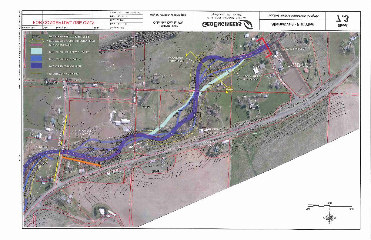
17 Site Map:
18
Project Pre-Application
 Project Pre-Application (Please use the Up, Down, Left & Right Arrows to move from Field to Field) Project Title: Pataha Culverts Submitting Organization: The Nez Perce Tribe Project Contact Information
Series 2016A-2 (Green Bonds) Final Proceeds Allocation April 2016
 Final Proceeds Allocation April 2016") Series 2016A-2 (Green Bonds) Final Proceeds Allocation April 2016 James L. McIntire Washington State Treasurer Summary The State of Washington offered green bonds to investors in September 2015, with approximately
Series 2016A-2 (Green Bonds) Final Proceeds Allocation April 2016 James L. McIntire Washington State Treasurer Summary The State of Washington offered green bonds to investors in September 2015, with approximately
DRAFT SOUTH FORK SKYKOMISH RIVER
 DRAFT SOUTH FORK SKYKOMISH RIVER 9 levees and revetments / Approximately 1.1 miles of river bank are armored Revetments provide limited, localized erosion protection, but impact habitat Frequent and costly
Chehalis River Basin Flood Damage Reduction 2013-2015 Capital Budget Approved by Legislature in June 2013
 Chehalis River Basin Flood Damage Reduction 2013-2015 Capital Budget Approved by Legislature in June 2013 1. Design alternatives for large capital flood projects (basinlevel water retention and Interstate
3. The submittal shall include a proposed scope of work to confirm the provided project description;
 QIN Shoreline Master Program Project Summary The Shoreline Master Program (SMP) development process for the Quinault Indian Nation (QIN) includes the completion of inventory and analysis report with corresponding
King County, Washington Policies and Practice for the Use of Eminent Domain For Flood Risk Reduction
 King County, Washington Policies and Practice for the Use of Eminent Domain For Flood Risk Reduction Introduction Eminent domain refers to the power possessed by the state over all property within the
SKAGIT COUNTY HABITAT IMPROVEMENT PLAN
 SKAGIT COUNTY HABITAT IMPROVEMENT PLAN Public Works Department Natural Resources Division August 2012 Mission To create and advance restoration strategies that support Skagit County goals for promoting
Proposal to the Trinity Adaptive Management Working Group (TAMWG)
") Proposal to the Trinity Adaptive Management Working Group (TAMWG) Request that the TAMWG recommend that the Trinity River Restoration Program fund BLM to purchase the Weigel parcel at Gold Bar (river mile
Proposal to the Trinity Adaptive Management Working Group (TAMWG) Request that the TAMWG recommend that the Trinity River Restoration Program fund BLM to purchase the Weigel parcel at Gold Bar (river mile
How To Manage Water Resources In The Yakima Basin
 Yakima Basin Integrated Water Resource Management Plan October 23, 2014 Presented by Derek Sandison, Director Office of Columbia River Photo Courtesy of Tom Ring Basin size: 6,155 sq. miles Population:
A Cost Analysis of Stream Compensatory Mitigation Projects in the Southern Appalachian Region 1
 A Cost Analysis of Stream Compensatory Mitigation Projects in the Southern Appalachian Region 1 J. Bonham 2 and K. Stephenson Abstract Recently the US Army Corps of Engineers (the Corps) has increased
ESRI_UC_2015_No843_Integrating Flood Risk Management and Salmon Habitat Restoration_CampbellSW
 ESRI_UC_2015_No843_Integrating Flood Risk Management and Salmon Habitat Restoration_CampbellSW Advancing an integrated approach to flood risk management and habitat restoration planning in the Puget Sound
An Introduction to Conservation Covenants. A Guide For Developers and Planning Departments
 An Introduction to Conservation Covenants A Guide For Developers and Planning Departments The Land Trust Alliance of BC Revised April 2007 Photo: Millard Piercy Watershed Courtenay, BC several conservation
Laws of Minnesota 2009 Final Report
 Lessard-Sams Outdoor Heritage Council Laws of Minnesota 2009 Final Report Dat e: August 20, 2013 Program or Project T it le: Habitat Protection, Phase 1 Funds Recommended: $1,000,000 Manager's Name: T
Addendum D. Nomination of Moody Wash ACEC
 Addendum D Nomination of Moody Wash ACEC Moody Wash ACEC is hereby nominated by Citizens for Dixie s Future to: BLM St. George Field Office 345 East Riverside Drive St. George, UT 84790 Moody Wash is a
Monitoring the Benefits of Instream Habitat Diversity. Entiat River, Chelan County, Washington
 Monitoring the Benefits of Instream Habitat Diversity Entiat River, Chelan County, Washington Bureau of Reclamation Bonneville Power Administration May 2013 This is an update of the report that first occurred
WRIA 8 Staff Team DRAFT 2017 Work Plan
 WRIA 8 Salmon Recovery Council & Regional/State Coordination WRIA 8 Salmon Recovery Council Schedule and staff WRIA 8 Salmon Recovery Council (SRC) meetings. Coordinate overall WRIA 8 implementation effort
Produced by: Conservation Trust for North Carolina on behalf of. with funding from WalMart
 Produced by: Conservation Trust for North Carolina on behalf of with funding from WalMart 4th Edition 2010 by the Conservation Trust for North Carolina and N.C. Coastal Land Trust 4th Edition Credits:
THE DUNGENESS WATER EXCHANGE. Washington Water Trust March 13, 2013 Sequim Realtors
 THE DUNGENESS WATER EXCHANGE Washington Water Trust March 13, 2013 Sequim Realtors PRESENTATION OVERVIEW Who is the Washington Water Trust? What is the Dungeness Water Exchange? How does the Exchange provide
Leveraging Ohio s Clean Water SRF Program to Fund Stream and Wetland Restoration and Protection Projects
 Leveraging Ohio s Clean Water SRF Program to Fund Stream and Wetland Restoration and Protection Projects Association of State Wetland Managers 2014 State/Tribal/Federal Coordination Meeting Shepherdstown,
Rhode Island NRCS received approximately $2.4 million in ARRA funds to implement four floodplain easement projects.
 American Recovery and Reinvestment Act (ARRA) Emergency Watershed Protection Program Floodplain Easements Rhode Island Natural Resources Conservation Service Rhode Island NRCS received approximately $2.4
The Effects of a Riparian Forest on Water Temperatures in the Restoration Area
 Study 31 The Effects of a Riparian Forest on Water Temperatures in the Restoration Area Final 2015 Monitoring and Analysis Plan January 2015 1.0 The Effects of a Riparian Forest on Water Temperatures
Flood Risk Management
 Flood Risk Management Value of Flood Risk Management Every year floods sweep through communities across the United States taking lives, destroying property, shutting down businesses, harming the environment
Flood Risk Management
 Flood Risk Management Value of Flood Risk Management Value to Individuals and Communities Every year floods sweep through communities across the United States taking lives, destroying property, shutting
AN INITIATIVE TO IMPROVE
 L OW E R C A R M E L R I V E R A N D L AG O O N F L O O D P L A I N R E S TO R AT I O N A N D E N H A N C E M E N T P R O J E C T AN INITIATIVE TO IMPROVE FLOOD PROTECTION RESTORE AND PROTECT RIPARIAN
Walla Walla Bi state Stream Flow Enhancement Study Interim Progress Report. Department of Ecology Grant No. G1400656.
 Walla Walla Bi state Stream Flow Enhancement Study Interim Progress Report Department of Ecology Grant No. G1400656 Submitted by: Walla Walla Watershed Management Partnership Walla Walla, WA Walla Walla
LEAGUE NOTES ON APPROVED COMMUNITY WATER SUPPLY PLAN
 1 AUGUST 2011 LEAGUE NOTES ON APPROVED COMMUNITY WATER SUPPLY PLAN KEY ELEMENTS OF THE PLAN: 1. Replace the existing unsafe Ragged Mountain dam with a new dam and raise the reservoir pool level initially
Lower Dungeness River Estuarine & Floodplain Restoration
 PARTNERS: Clallam County; Jamestown S Klallam Tribe; WA Department of Fish & Wildlife; US Army Corps of Engineers; US Fish & Wildlife Service; WA Department of Transportation; WA Department of Ecology;
Penticton Creek May 4, 2015 Council Meeting
 Penticton Creek May 4, 2015 Council Meeting Penticton Creek Council Meeting May 4, 2015 Penticton Creek in the Early Years Penticton Creek Council Meeting May 4, 2015 Penticton Creek Today Penticton Creek
Stream Restoration Account of Flood and Drought Response Fund Grant Program Guidance May 2014
 Background Stream Restoration Account of Flood and Drought Response Fund Grant Program Guidance May 2014 Senate Bill 14-179, proposed to the 2014 Colorado General Assembly, establishes funding for stream
Project Area 3 Implementation Summary
 Project Area 3 Implementation Summary * Project Reach: Project Area 03 is located in the upper Tucannon River Watershed (RM 46.6 48.1) near Dayton WA. The 1.5 mile long project reach was identified in
FishAmerica Foundation and B.A.S.S. Nation Application for Funding for Community-based Fisheries and Aquatic Resource Conservation Projects
 FishAmerica Foundation and B.A.S.S. Nation Application for Funding for Community-based Fisheries and Aquatic Resource Conservation Projects Reference #: Date Received: (FAF/B.A.S.S. Internal Use) Applicants
3. Adaptive Management Program
 3. Adaptive Management Program 3.1 Introduction This chapter provides a brief background on the Forest Practices Adaptive Management Program (AMP) and accomplishments to date. In large part, those accomplishments
PUBLIC NOTICE Application for Permit
 PUBLIC NOTICE Application for Permit 30-Day Notice Issue Date: June 20, 2016 Expiration Date: July 20, 2016 US Army Corps of Engineers No: NWP-2010-535 Oregon Department of State Lands No: 58311-RF Interested
King County Flood Hazard Management Plan Update Cedar/ Sammamish Rivers. Public Meeting December 5, 2012
 King County Flood Hazard Management Plan Update Cedar/ Sammamish Rivers Public Meeting December 5, 2012 Goals of the Presentation Cedar and Sammamish R. Plan Update Context - Brief summary info about the
Gunnison Basin Wild and Scenic Stakeholder Group Delta Performing Arts Center, 822 Grand Ave., Delta Colorado December 6, 2010, 7:00 p.m.
 Gunnison Basin Wild and Scenic Stakeholder Group Delta Performing Arts Center, 822 Grand Ave., Delta Colorado December 6, 2010, 7:00 p.m. DRAFT NOTES SUMMARY Stakeholders shared information on the West
Prioritizing Riparian Restoration at the Watershed, Reach and Site Scales. Richard R. Harris University of California, Berkeley Cooperative Extension
 Prioritizing Riparian Restoration at the Watershed, Reach and Site Scales Richard R. Harris University of California, Berkeley Cooperative Extension Issues Riparian communities provide multiple benefits
Michigan Wetlands. Department of Environmental Quality
 Department of Environmental Quality Wetlands are a significant component of Michigan s landscape, covering roughly 5.5 million acres, or 15 percent of the land area of the state. This represents about
Wisconsin Land Trusts
 Wisconsin Land Trusts What is a Land Trust? Conservation land is essential to the health and beauty of Wisconsin. Land trusts are non-profit organizations that help protect land for public benefit. There
Colorado Natural Heritage Program
 CNHP s mission is to preserve the natural diversity of life by contributing the essential scientific foundation that leads to lasting conservation of Colorado's biological wealth. Colorado Natural Heritage
JOB DESCRIPTION. GS-11 $46,006 - $59,801 Annual/Full Benefits GS-12 $55,138 - $71,679 Annual/Full Benefits
 OPEN: CLOSE: OR UNTIL FILLED EXEMPT NON-EXEMPT_X_ JOB DESCRIPTION POSITION: RESPONSIBLE TO: SALARY: FLUVIAL GEOMORPHOLOGIST Senior Aquatics Biologist GS-11 $46,006 - $59,801 Annual/Full Benefits GS-12
Chapter 11. Costs and Funding
 Chapter 11. 11.1 Financial Summary...11-1 11.2 Program Costs...11-2 11.2.1 Habitat Conservation Program Costs...11-2 Bull Run Habitat Conservation Measures...11-2 Offsite Sandy River Basin Habitat Conservation
Request for Proposal. Request for Proposal for GreenLink Bellingham Technical Analysis and Community Engagement, Bellingham, WA
 Request for Proposal Request for Proposal for GreenLink Bellingham Technical Analysis and Community Engagement, Bellingham, WA 1 Table of Contents: Section A: Project Scope... 3 Section B: Background...
Background Information: The Mamquam River Floodplain Restoration Project
 Background Information: The Mamquam River Floodplain Restoration Project The Mamquam River Floodplain Restoration project is being undertaken in partnership with the Squamish River Watershed Society, Fisheries
St. Vrain Watershed Master Plan Thursday, January 23 10:00 a.m. 12:15 p.m.
 St. Vrain Watershed Master Plan Thursday, January 23 10:00 a.m. 12:15 p.m. City Council Study Session Room City of Longmont Civic Center, 350 Kimbark Street, Longmont Minutes 1. Introductions a. Jeff Crane
Lake Erie Commission OVERVIEW
 LEC - Overview No GRF funding. Lake Erie Commission Funding is increased 5.0% in FY02 and 3.2% in FY03. OVERVIEW The Lake Erie Commission (LEC) is responsible for coordinating state policies and programs
Steelhead Recovery in San Juan and Trabuco Creeks Watershed
 Steelhead Recovery in San Juan and Trabuco Creeks Watershed Are there fish now? Overview Final San Juan and Trabuco Creeks Watershed Management Plan Fish & Game Implementation NOAA Steelhead Recovery and
Wildlife Habitat Conservation and Management Program
 Wildlife Habitat Conservation and Management Program Manual for Counties and Cities Oregon Department of Fish and Wildlife 2015 Table of Contents 1. Introduction Purpose of the habitat program Objective
Year 2 7-15-10 Post Restoration Monitoring Summary Rock Creek Project Monitoring and Analysis conducted by Bio-Surveys,LLC. Contact: strask@casco.
 Year 2 7-15-10 Post Restoration Monitoring Summary Rock Creek Project Monitoring and Analysis conducted by Bio-Surveys,LLC. Contact: strask@casco.net Project Sponsors include: The City of Corvallis Oregon
33 CFR PART 332 COMPENSATORY MITIGATION FOR LOSSES OF AQUATIC RESOURCES. Authority: 33 U.S.C. 401 et seq. ; 33 U.S.C. 1344; and Pub. L. 108 136.
 33 CFR PART 332 COMPENSATORY MITIGATION FOR LOSSES OF AQUATIC RESOURCES Authority: 33 U.S.C. 401 et seq. ; 33 U.S.C. 1344; and Pub. L. 108 136. Source: 73 FR 19670, Apr. 10, 2008, unless otherwise noted.
Management Plan Template For Conservation Easements Held by CPW
 Management Plan Template For Conservation Easements Held by CPW The following template provides guidelines for developing a management plan for a property that will have a Conservation Easement held by
PROJECT STATUS REPORT. Development of microhabitat suitability criteria for fry and juvenile salmonids of the Trinity River
 PROJECT STATUS REPORT Development of microhabitat suitability criteria for fry and juvenile salmonids of the Trinity River Prepared for: Trinity River Restoration Program P.O. Box 13 1313 South Main St.
STREAMFLOW RESTORATION PRIORITY AREAS
 STREAMFLOW RESTORATION PRIORITY AREAS Synopsis The Water Resources Department and the Department of Fish and Wildlife jointly identified priority areas for streamflow restoration in basins throughout the
COMPREHENSIVE PLAN SECTION B, ELEMENT 4 WATER RESOURCES. April 20, 2010 EXHIBIT 1
 COMPREHENSIVE PLAN SECTION B, ELEMENT 4 WATER RESOURCES April 20, 2010 EXHIBIT 1 ELEMENT 4 WATER RESOURCES TABLE OF CONTENTS 4.1 INTRODUCTION 4.2 GOALS AND POLICIES 4.2.A General Goals and Policies 1 4.2.B
Land Protection Planning for the National Wildlife Refuge System
 March 2012 Planning Information Brochure 1 Land Protection Planning for the National Wildlife Refuge System The following questions are often asked when the U.S. Fish and Wildlife Service (Service) begins
2015-2016 Request for Applications to Host SNAP Members
 2015-2016 Request for Applications to Host SNAP Members The Sierra Nevada AmeriCorps Partnership (SNAP) invites Sierra Nevada conservation organizations, agencies and tribal governments to apply to host
5.14 Floodplains and Drainage/Hydrology
 I-70 East Final EIS 5.14 Floodplains and Drainage/Hydrology 5.14 Floodplains and Drainage/Hydrology This section discusses floodplain and drainage/hydrology resources and explains why they are important
Clean Water Services. Ecosystems Services Case Study: Tualatin River, Washington
 Viewed broadly, the concept of ecosystem services describes the many resources and services provided by nature. Typically, traditional planning and development practices do not adequately represent the
COASTAL CONSERVANCY. Staff Recommendation May 26, 2016 LOWER GREEN VALLEY CREEK COHO MIGRATION ENHANCEMENT
 COASTAL CONSERVANCY Staff Recommendation May 26, 2016 LOWER GREEN VALLEY CREEK COHO MIGRATION ENHANCEMENT Project No. 16-014-01 Project Manager: Lisa Ames RECOMMENDED ACTION: Authorization to disburse
UTILITIZATION OF ECOHYDROLOGIC MODELS IN FLOODPLAIN FISH PASSAGE AND HABITAT RESTORATION EVALUATION
 UTILITIZATION OF ECOHYDROLOGIC MODELS IN FLOODPLAIN FISH PASSAGE AND HABITAT RESTORATION EVALUATION Joshua A. Israel, Fish Biologist, U.S Bureau of Reclamation, Sacramento, CA. jaisrael@usbr.gov; Paul
REQUESTS FOR PROPOSALS
 REQUESTS FOR PROPOSALS Chelsea Village Flood Study (VT Rt.110 Bridge 10, Maple Street Bridge 45, N. Court St Bridge 43) Two Rivers-Ottauquechee Regional Commission A. INTRODUCTION The Two Rivers-Ottauquechee
NYCIDA PROJECT COST/BENEFIT ANALYSIS June 5, 2014
 NYCIDA PROJECT COST/BENEFIT ANALYSIS June 5, 2014 APPLICANT Skyline Restoration Inc. CGI Northeast, Inc. Spring Scaffolding LLC Metropolitan Northeast LLC 11-20 37 th Avenue Long Island City, NY 11101
Thank you to all of our 2015 sponsors: Media Partner
 Thank you to all of our 2015 sponsors: Media Partner Channel Naturalization: Planning and Implementation in Peel Region TRIECA March 25 & 26, 2015 Peel Region Channel Remediation Strategy An Urban Context
March 2011 DRAFT. I. Working Forest Easements:
 March 2011 DRAFT Minnesota Department of Natural Resources (DNR) Division of Forestry Federal Forest Legacy Program and Minnesota Forests for the Future Program Conservation Easement Stewardship and Monitoring
San Diego Integrated Regional Water Management Implementation Grant Proposal Economic Analysis Flood Damage Reduction Costs and Benefits
 Attachment 9 San Diego Integrated Regional Water Management Economic Analysis Flood Damage Reduction Costs and Benefits Attachment 9 consists of the following items: Flood Damage Reduction Costs and Benefits.
ECONOMIC ANALYSIS FLOOD DAMAGE REDUCTION. Lower Carmel River Floodplain Restoration and Enhancement Project
 ECONOMIC ANALYSIS FLOOD DAMAGE REDUCTION Lower Carmel River Floodplain Restoration and Enhancement Project I. Description of the Project and its Relationship to Other Projects in the Proposal The Lower
COMMUNITY CERTIFICATIONS
 National Flood Insurance Program Community Rating System COMMUNITY CERTIFICATIONS Public reporting burden for this form is estimated to average 4 hours for annual recertification, per response. The burden
General Permit for Activities Promoting Waterway - Floodplain Connectivity [working title]
![General Permit for Activities Promoting Waterway - Floodplain Connectivity [working title]](/thumbs/39/18645965.jpg "General Permit for Activities Promoting Waterway - Floodplain Connectivity [working title]") General Permit for Activities Promoting Waterway - Floodplain Connectivity [working title] Purpose These rules set forth the conditions under which a person may, without an individual removal-fill permit
General Permit for Activities Promoting Waterway - Floodplain Connectivity [working title] Purpose These rules set forth the conditions under which a person may, without an individual removal-fill permit
PROJECT INFORMATION REPORT REHABILITATION OF FLOOD CONTROL WORKS ROCK CREEK LEVEE NAC-2-09. Table of Contents
 PROJECT INFORMATION REPORT REHABILITATION OF FLOOD CONTROL WORKS ROCK CREEK LEVEE NAC-2-09 Table of Contents EXECUTIVE SUMMARY... 1 PROJECT REPORT... 3 1. Project Identification... 3 2. Project Authority...
HCP Team Meeting. November 18, 2015. icfi.com
 HCP Team Meeting November 18, 2015 icfi.com 1 Welcome and Introductions Where are we in the HCP process Hydrology modeling update Native fish survey Fish translocation Finalize covered activities Next
Restoring Anadromous Fish Habitat in Big Canyon Creek Watershed. Summary Report 2002
 Restoring Anadromous Fish Habitat in Big Canyon Creek Watershed Summary Report 2002 DOE/BP-00005268-5 November 2002 This Document should be cited as follows: "Restoring Anadromous Fish Habitat in Big Canyon
The project site lies within an AE Zone and portions lie within the regulated floodway. Development of this site is subject to TCLUO, Section 3.060.
 Introduction This application is for the Southern Flow Corridor-Landowner Preferred Alternative, a flood mitigation and tidal wetland restoration project. The Port of Tillamook Bay is the applicant in
Section 5: Conserve to Enhance Program Goals What is Conserve to Enhance All About?
 Section 5: Conserve to Enhance Program Goals What is Conserve to Enhance All About? Conserve to Enhance (C2E) was originally conceptualized as an approach to giving the environment a seat at the table
1. INTRODUCTION 5. THE PERMIT PROCESS
 1. INTRODUCTION Laws of the United States and the State of Iowa have assigned the US Army Corps of Engineers and the Iowa Department of Natural Resources with specific and different regulatory roles designed
SPAC Comments on Initial SMP Chapter 1 and 3 Proposed Language
 Comments requested as follow-up to 12/14/06 SPAC meeting discussion The following comments were submitted by four SPAC members: SMP Chapter 1 Introduction Jerry Gorsline: Some thoughts on defining NNL
Gold Ray Dam Interagency Technical Team Meeting
 Gold Ray Dam Interagency Technical Team Meeting Agenda Public Outreach, Funding, Monitoring EA/BA/Permit Updates Deconstruction Plans Fish Passage & Salvage Plan Hydraulic Modeling Next Steps Public Outreach,
Arkansas River Corridor Vision & Master Plan
 A r k a n s a s R I v e r C o r r I d o r P l a n Arkansas River Corridor Vision & Master Plan July 2005 Indian Nations Council of Governments A r k a n s a s R I v e r C o r r I d o r P l a n Partnership
21st International Conference of The Coastal Society
 21st International Conference of The Coastal Society MARINE STEWARDSHIP AREA OFFERS A MODEL FOR INTEGRATING SCIENCE, MANAGEMENT, STEWARDSHIP AND ECOSYSTEM THINKING IN THE CONSERVATION OF COASTAL RESOURCES
Columbia River Project Water Use Plan. Monitoring Program Terms of Reference LOWER COLUMBIA RIVER FISH MANAGEMENT PLAN
 Columbia River Project Water Use Plan LOWER COLUMBIA RIVER FISH MANAGEMENT PLAN CLBMON-45 Lower Columbia River Fish Indexing Surveys 31 August 2007 1.0 OVERVIEW LOWER COLUMBIA RIVER FISH MANAGEMENT PLAN
Department of the Interior. Departmental Manual
 Page 1 of 10 Department of the Interior Departmental Manual Effective Date: 10/23/2015 Series: Public Lands Part 600: Public Land Policy Chapter 6: Implementing Mitigation at the Landscape-scale Originating
Niki L. Pace, Research Counsel Mississippi Alabama Sea Grant Legal Program September 15, 2009
 Niki L. Pace, Research Counsel Mississippi Alabama Sea Grant Legal Program September 15, 2009 What is a land trust? A land trust is a private, nonprofit organization whose mission is the acquisition and
Monitoring Riparian Areas With a Camera
 Monitoring Riparian Areas With a Camera By Michael DeLasaux 1, Holly George 2, and Philip Mainwaring 3 Riparian areas are next to streams, springs, rivers, ponds and lakes. Physical characteristics that
STANDARDS FOR RANGELAND HEALTH ASSESSMENT FOR SAGEHEN ALLOTMENT #0208
 STANDARDS FOR RANGELAND HEALTH ASSESSMENT FOR SAGEHEN ALLOTMENT #0208 RANGELAND HEALTH STANDARDS - ASSESSMENT SAGEHEN ALLOTMENT #0208 STANDARD 1 - UPLAND WATERSHED This standard is being met on the allotment.
REQUEST FOR PROPOSALS
 PROJECT: CONSERVATION PLANNING, GIS MAPPING & ANALYSIS, AND PROJECT MANAGEMENT SERVICES REQUEST FOR PROPOSALS #RFP-2016-05 The Santa Clara Valley Open Space Authority is issuing this Request for Proposals
Permanently preserving privately owned productive agricultural land ensures a stable land base for the future of the agricultural industry.
 F A R M L A N D P R E S E R V A T I O N Permanently preserving privately owned productive agricultural land ensures a stable land base for the future of the agricultural industry. Farmland preservation,
CHAPTER I: INTRODUCTION. Background
 CHAPTER I: INTRODUCTION Background California State Law requires each county to adopt a General Plan for the physical development of the county and any land outside its boundaries which bears relation
Past and Current Research on Natural Resource Issues in the Blue Mountains
 Past and Current Research on Natural Resource Issues in the Blue Mountains Recreation, Hunting, Access Livestock Production (and Wild Ungulate Ecology) Restoration Timber Harvest, Production Biodiversity,
WEED MANAGEMENT PLAN FOR. (NAME of PROPERTY or MANAGED AREA) (TOWN or COUNTY, STATE) (TIME PERIOD; e.g. 1996-2000)
 (TOWN or COUNTY, STATE) (TIME PERIOD; e.g. 1996-2000)") (WEED MANAGEMENT PLAN OUTLINE FOR PUBLIC LAND MANAGERS) (Note: This outline is a modification of a weed management plan template produced by The Nature Conservancy) WEED MANAGEMENT PLAN FOR (NAME of PROPERTY
(WEED MANAGEMENT PLAN OUTLINE FOR PUBLIC LAND MANAGERS) (Note: This outline is a modification of a weed management plan template produced by The Nature Conservancy) WEED MANAGEMENT PLAN FOR (NAME of PROPERTY
San Juan County / WRIA2 Lead Entity Program for Salmon Recovery
 San Juan County / WRIA2 Lead Entity Program for Salmon Recovery Photo: Rick Gould Barbara Rosenkotter Lead Entity Coordinator 360-370-7593 BarbaraR@sanjuanco.com www.sjcmrc.org/projects/salmon-recovery.aspx
RE: Docket # COE 2010 0035; ZRIN 0710 ZA05 Submitted via email to NWP2012@usace.army.mil and Rulemaking Portal at www.regulations.gov.
 April 18, 2011 U.S. Army Corps of Engineers Attn: CECW CO R 441 G Street, N.W. Washington, DC 20314 1000 RE: Docket # COE 2010 0035; ZRIN 0710 ZA05 Submitted via email to NWP2012@usace.army.mil and Rulemaking
REQUEST FOR QUALIFICATIONS. For ENGINEERING SERVICES
 REQUEST FOR QUALIFICATIONS For ENGINEERING SERVICES For FY17/FY18 Fiscal Years Mecklenburg County Storm Water Services (MCSWS) Projects Mecklenburg County, North Carolina June 14, 2016 Submittal Deadline:
The Dungeness Water Exchange Mitigation Guidance Document. April 2013
 The Dungeness Water Exchange Mitigation Guidance Document April 2013 Prepared by Washington Water Trust 1530 Westlake Avenue N, Suite 400 Seattle, WA 9810 Table of Contents- Dungeness Water Exchange Mitigation
Habitat Opportunities in the Duwamish Transition Zone
 Duwamish Blueprint: Habitat Opportunities in the Duwamish Transition Zone November 13, 2014 Presentation to the WRIA 9 Watershed Ecosystem Forum Elissa Ostergaard, Planning and Stewardship Coordinator
Performance Standard 8:
 Overview of Performance Standards on Environmental and Social Sustainability 1. IFC s Sustainability Framework articulates the Corporation s strategic commitment to sustainable development, and is an integral
Conservation Tax Credit Regulations Chapter 391-1-6 A-1 RULES OF GEORGIA DEPARTMENT OF NATURAL RESOURCES CHAPTER 391-1-6
 Conservation Tax Credit Regulations Chapter 391-1-6 A-1 RULES OF GEORGIA DEPARTMENT OF NATURAL RESOURCES CHAPTER 391-1-6 GEORGIA CONSERVATION TAX CREDIT PROGRAM TABLE OF CONTENTS 391-1-6-.01 Purpose and
As stewards of the land, farmers must protect the quality of our environment and conserve the natural resources that sustain it by implementing
 N A T U R A L R E S O U R C E C O N S E R V A T I O N As stewards of the land, farmers must protect the quality of our environment and conserve the natural resources that sustain it by implementing conservation
Appendix C. Project Opportunities. Middle Twisp River (RM 7.8 18.12)
") Appendix C Project Opportunities Middle Twisp River (RM 7.8 18.12) This table describes project opportunities by project area. Locator maps of the project opportunities are included below the table. Reach
Appendix C Project Opportunities Middle Twisp River (RM 7.8 18.12) This table describes project opportunities by project area. Locator maps of the project opportunities are included below the table. Reach
Streambank stabilization, streambank fencing, nuisance species control, riparian zone management
 Streambank stabilization, streambank fencing, nuisance species control, riparian zone management Stream Restoration Cost Estimates BRIAN BAIR USDA Forest Service Gifford-Pinchot National Forest 1262 Hemlock
Cost of Service Studies For the San Antonio, California Water District
 REQUEST FOR PROPOSALS TO PROVIDE: CONSULTING SERVICES TO THE SAN LORENZO VALLEY WATER DISTRICT PROJECT TITLE: ENTERPRISE WIDE COST OF SERVICE FINANCIAL STUDY RESPONSE DUE BEFORE 3:00 P.M. ON JANUARY 15,
 Coldwater Heritage Partnership Implementation Grant Final Report Morrison Run Watershed Restoration Project Western Pennsylvania Conservancy Project Summary The goal of the Morrison Run Watershed Restoration
Develop and Implement a Pilot Status and Trend Monitoring Program for Salmonids and their Habitat in the Wenatchee and Grande Ronde River Basins.
 Project ID: 35019 Title: Develop and Implement a Pilot Status and Trend Monitoring Program for Salmonids and their Habitat in the Wenatchee and Grande Ronde River Basins. Response to ISRP Comments A. This