Project Area 3 Implementation Summary
|
|
|
- Chloe Marsh
- 8 years ago
- Views:
Transcription
1 Project Area 3 Implementation Summary
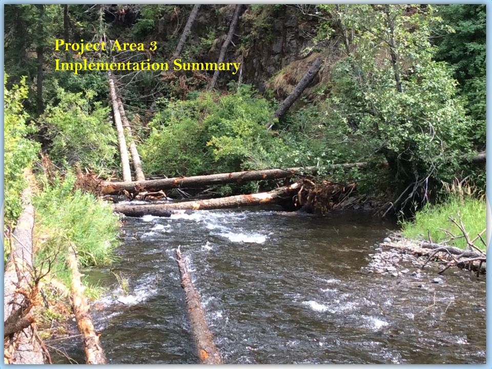
2 * Project Reach: Project Area 03 is located in the upper Tucannon River Watershed (RM ) near Dayton WA. The 1.5 mile long project reach was identified in the Tucannon Restoration Plan (Anchor Nov 2011) as a high priority identifying potential for increased large wood driven channel complexity. Above Image: Pre-project photo of typical channel form within the project reach. Project: Eric Hoverson of CTUIR sponsored PA-03 in 2012 and began design and permitting using CTUIR funds from the CTUIR Tucannon Habitat Project. In 2013, implementation funds were provided from the Tucannon Habitat Programmatic. The project design involved the construction of 5 engineered log jams at the downstream of the project, for the purpose of providing channel stability near existing infrastructure. The 5 structures are anchored with rock to increase stability. A helicopter was used to place 47 additional structures which are unanchored and are configured for the purpose of improving hydraulic complexity and increasing floodplain connectivity. Project used 268 whole trees placed into 52 single or multiple log configurations over 1.35 miles of the project reach. Implementation: Was completed on July 13, 2014, using a combination of Helicopter placed whole trees and excavator placed partial trees and ballast boulders. Preliminary Results: Helicopter placed whole trees and excavator placed partial trees and ballast boulders created complexity and back water effects. Above: Yellow arrow illustrated pre-project condition. Below: Yellow arrow indicated post treatment at same location. Log jam in lower right is a natural jam used as an example for natural condition. Eric Hoverson, Confederated Tribe of the Umatilla Indian Reservation (Project Sponsor and Construction Management & Funding), Tetra Tech (Design and Engineering), WDFW (Landowner); USFS (Landowners, Partners & Materials); Snake River Salmon Recovery Board - Tucannon Habitat Programmatic (Coordination Support and Funding), Bonneville Power Administration (Funding)

3 Project Area 3, Tucannon River channel complexity placed using Vertol helicopter, July 2014 by the Confederated Tribes of the Umatilla Indian Reservation Tucannon Program. (Upper) Pre-project condition of the meander jam and channel spanning structure built below Little Tucannon confluence, ground photo left and aerial image right. (Lower left) Logs being placed by the helicopter, (lower right) final product captured in September Note the natural jam in the lower right of the lower right photo, it has been used as a reference for channel spanning structures in the Tucannon.
 Logs being placed by the helicopter, (lower right) final product captured in September 2014.")
4 Project Area 3, Tucannon River channel complexity placed using Vertol helicopter, July 2014 by the Confederated Tribes of the Umatilla Indian Reservation Tucannon Program. The Google image take August 2014 illustrates the helicopter placed structure overlain with the rapid habitat surveys collected for as built in September The yellow icons indicate the positions of placed unanchored wood and the green indicate natural wood. The inset shows structure 34 located on the left side of the image. The light orange polygon indicates the supplemental CHaMP monitoring site extent for the site supported under the Programmatic.

5 Project Area 3, Tucannon River channel complexity placed using Vertol helicopter and conventional methods, July 2014 by the Confederated Tribes of the Umatilla Indian Reservation Tucannon Program. Upper left, log channel spanner placed using conventional excavator for the purpose of providing structural stability near the bottom of the project reach. Note the large rock placed on top of the wood elements to provide ballast to the structure during high flow. Lower left is a pre-structure view of the right upper and lower images in post project.

Tucannon River Large Wood Restoration Project Area 10 Final Report
 Tucannon River Large Wood Restoration Project Area 10 Final Report Washington State Dept. of Fish and Wildlife W.T. Wooten Wildlife Area, Columbia County, WA Introduction The Tucannon River Large Wood
Streambank stabilization, streambank fencing, nuisance species control, riparian zone management
 Streambank stabilization, streambank fencing, nuisance species control, riparian zone management Stream Restoration Cost Estimates BRIAN BAIR USDA Forest Service Gifford-Pinchot National Forest 1262 Hemlock
Project Pre-Application
 Project Pre-Application (Please use the Up, Down, Left & Right Arrows to move from Field to Field) Project Title: Pataha Culverts Submitting Organization: The Nez Perce Tribe Project Contact Information
Appendix C. Project Opportunities. Middle Twisp River (RM 7.8 18.12)
") Appendix C Project Opportunities Middle Twisp River (RM 7.8 18.12) This table describes project opportunities by project area. Locator maps of the project opportunities are included below the table. Reach
Appendix C Project Opportunities Middle Twisp River (RM 7.8 18.12) This table describes project opportunities by project area. Locator maps of the project opportunities are included below the table. Reach
Final Report. Dixie Creek Restoration Project. Funded by Plumas Watershed Forum
 Final Report Dixie Creek Restoration Project Funded by Plumas Watershed Forum Plumas Corporation January 2009 1 Background FR-CRM staff presented this project to the Dixie Valley Landowners Association
Neversink River East Branch
 Neversink River East Branch Management Unit 10 Summary of Post-Flood Recommendations Intervention Level Full restoration of the stream reach including the eroding bank site between Station 38380 and Station
Sims Bayou Federal Flood Damage Reduction Project
 Sims Bayou Federal Flood Damage Reduction Project A. Gene Rushing, Jr., P.E., PMP HCFCD Project Manager January 15, 2014 Harris County s Watersheds Historical Flooding in Harris County 1929 1935 HCFCD
Walla Walla Bi state Stream Flow Enhancement Study Interim Progress Report. Department of Ecology Grant No. G1400656.
 Walla Walla Bi state Stream Flow Enhancement Study Interim Progress Report Department of Ecology Grant No. G1400656 Submitted by: Walla Walla Watershed Management Partnership Walla Walla, WA Walla Walla
The Teton Creek Restoration Project Summary:
 The Teton Creek Restoration Project Summary: The Teton Creek Restoration Project area extends for approximately one mile upstream from the Cemetery Road Bridge and includes the Aspen Pointe, The Aspens
Monitoring the Benefits of Instream Habitat Diversity. Entiat River, Chelan County, Washington
 Monitoring the Benefits of Instream Habitat Diversity Entiat River, Chelan County, Washington Bureau of Reclamation Bonneville Power Administration May 2013 This is an update of the report that first occurred
Passive Restoration 101: Framework and Techniques Overview. Amy Chadwick, Great West Engineering August 26, 2015 Butte, America
 Passive Restoration 101: Framework and Techniques Overview Amy Chadwick, Great West Engineering August 26, 2015 Butte, America What Defines Passive Restoration? Process-based, nature-driven Minimal equipment
JOB DESCRIPTION. GS-11 $46,006 - $59,801 Annual/Full Benefits GS-12 $55,138 - $71,679 Annual/Full Benefits
 OPEN: CLOSE: OR UNTIL FILLED EXEMPT NON-EXEMPT_X_ JOB DESCRIPTION POSITION: RESPONSIBLE TO: SALARY: FLUVIAL GEOMORPHOLOGIST Senior Aquatics Biologist GS-11 $46,006 - $59,801 Annual/Full Benefits GS-12
Lower Dungeness River Estuarine & Floodplain Restoration
 PARTNERS: Clallam County; Jamestown S Klallam Tribe; WA Department of Fish & Wildlife; US Army Corps of Engineers; US Fish & Wildlife Service; WA Department of Transportation; WA Department of Ecology;
Proposal to the Trinity Adaptive Management Working Group (TAMWG)
") Proposal to the Trinity Adaptive Management Working Group (TAMWG) Request that the TAMWG recommend that the Trinity River Restoration Program fund BLM to purchase the Weigel parcel at Gold Bar (river mile
Proposal to the Trinity Adaptive Management Working Group (TAMWG) Request that the TAMWG recommend that the Trinity River Restoration Program fund BLM to purchase the Weigel parcel at Gold Bar (river mile
DRAFT SOUTH FORK SKYKOMISH RIVER
 DRAFT SOUTH FORK SKYKOMISH RIVER 9 levees and revetments / Approximately 1.1 miles of river bank are armored Revetments provide limited, localized erosion protection, but impact habitat Frequent and costly
How To Manage Water Resources In The Yakima Basin
 Yakima Basin Integrated Water Resource Management Plan October 23, 2014 Presented by Derek Sandison, Director Office of Columbia River Photo Courtesy of Tom Ring Basin size: 6,155 sq. miles Population:
Assessing Rivers for Restoration Purposes. Ann L. Riley Waterways Restoration Institute
 Assessing Rivers for Restoration Purposes Ann L. Riley Waterways Restoration Institute Assessing Rivers for Restoration Purposes Ann L. Riley Waterways Restoration Institute Assessing Rivers for Restoration
Chehalis River Basin Flood Damage Reduction 2013-2015 Capital Budget Approved by Legislature in June 2013
 Chehalis River Basin Flood Damage Reduction 2013-2015 Capital Budget Approved by Legislature in June 2013 1. Design alternatives for large capital flood projects (basinlevel water retention and Interstate
Streambank stabilization, streambank fencing, nuisance species control, riparian zone management
 Streambank stabilization, streambank fencing, nuisance species control, riparian zone management Stream Habitat Restoration Cost Considerations MARK COCKE, Civil Engineer Natural Resources Conservation
Mission Creek Flood Control & Restoration Project. City of Fremont, Alameda County
 Mission Creek Flood Control & Restoration Project City of Fremont, Alameda County Agenda Background Why are proposed improvements necessary? Proposed project components Challenges Construction schedule/phasing
121 FERC 62,167 UNITED STATES OF AMERICA FEDERAL ENERGY REGULATORY COMMISSION. Public Utility District No. 1 of Project No. 637-044 Chelan County
 121 FERC 62,167 UNITED STATES OF AMERICA FEDERAL ENERGY REGULATORY COMMISSION Public Utility District No. 1 of Project No. 637-044 Chelan County ORDER MODIFYING AND APPROVING LAKE CHELAN FISHERY PLAN,
Ruby River Grayling - Gravel Spawning Beds Monitoring Report January 2008
 Ruby River Grayling - Gravel Spawning Beds Monitoring Report January 2008 In partnership with Montana Department of Fish, Wildlife, and Parks (FWP), American Wildlands, and Wildlife Forever, the Madison
 Coldwater Heritage Partnership Implementation Grant Final Report Morrison Run Watershed Restoration Project Western Pennsylvania Conservancy Project Summary The goal of the Morrison Run Watershed Restoration
Steelhead Recovery in San Juan and Trabuco Creeks Watershed
 Steelhead Recovery in San Juan and Trabuco Creeks Watershed Are there fish now? Overview Final San Juan and Trabuco Creeks Watershed Management Plan Fish & Game Implementation NOAA Steelhead Recovery and
Floodplain Connectivity in Restoration Design
 Floodplain Connectivity in Restoration Design 2015 Symposium on Restoration in a Contaminated Environment: Lessons Learned and Challenges in Moving Forward Part II April 2015 Karin Boyd Applied Geomorphology,
St. Vrain Watershed Master Plan Thursday, January 23 10:00 a.m. 12:15 p.m.
 St. Vrain Watershed Master Plan Thursday, January 23 10:00 a.m. 12:15 p.m. City Council Study Session Room City of Longmont Civic Center, 350 Kimbark Street, Longmont Minutes 1. Introductions a. Jeff Crane
Quantifying Potential Floodplain Restoration Benefits in the Upper Mississippi River Basin, USA
 Quantifying Potential Floodplain Restoration Benefits in the Upper Mississippi River Basin, USA Michael Schwar, Ph.D. PE (MARS) Eileen Fretz (American Rivers) Mississippi River Commission/USACE Upper Mississippi
Plumas Watershed Forum. Review of Ongoing Projects. Updated 10/1/008
 Plumas Watershed Forum Review of Ongoing Projects Updated 10/1/008 Hosselkus II Restoration Project Approved Funding: $80,000 (A funds) Expended By 10/1/08: $79,603 This pond-and-plug creek restoration
HFQLG Project Evaluation Form
 HFQLG Evaluation Form Names: Watershed Restoration Defensible Fuel Profile Zone Loyalton Pines Wildland Urban Interface Fuels Reduction Types: Watershed Restoration - Implemented pond and plug restoration
Chehalis Basin Strategy Reducing Flood Damage and Enhancing Aquatic Species Technical Workshop
 Chehalis Basin Strategy Reducing Flood Damage and Enhancing Aquatic Species Technical Workshop Wednesday, October 30, 2013 from 8:30 am to 4:30 pm and Thursday, October 31, 2013 from 8:30 am to 3:00 pm
Capitalizing on Flooding as Passive. Hearts and Minds of the Musselshell
 Capitalizing on Flooding as Passive Restoration: Hearts and Minds of the Musselshell Karin Boyd Applied Geomorphology, Inc. Chris Boyer, Kestrel Aerial Services, Inc. Strategically t Adopting Flood Impacts
Block 291312 Inspection Englishman River - Island Timberlands -
 Block 291312 Inspection Englishman River - Island Timberlands - Prepared By: Shawn Hamilton and Associates 430 Odyssey Lane Victoria, BC V9E 2J2 Block 291312 Inspection Englishman River PMFLC #: IN-902-IT-C
SECTION 5.4 LOGJAM REMOVAL AND RIVER RESTORATION. Overview. Logjam Removal Using Heavy. Tools. Machinery. Large-Scale River Restoration
 SECTION 5.4 LOGJAM REMOVAL AND RIVER RESTORATION Overview Practice 401 Practice 402 Practice 403 Logjam Removal Using Hand-held Tools Logjam Removal Using Heavy Machinery Large-Scale River Restoration
CRS 610 Ventura County Flood Warning System Website
 CRS 610 Ventura County Flood Warning System Website Purpose This document gives instructions and a description of the information available via the Ventura County Watershed Protection District s (VCWPD)
The Economics of Culvert Replacement: Fish Passage in Eastern Maine
 The Economics of Culvert Replacement: Fish Passage in Eastern Maine Introduction The Natural Resources Conservation Service (NRCS) in Maine is working with Project SHARE (Salmon Habitat and River Enhancement)
ROGUE RIVER SPRING CHINOOK SALMON CONSERVATION PLAN. Evaluation of spring Chinook salmon spawning in Big Butte Creek, 2008
 ROGUE RIVER SPRING CHINOOK SALMON CONSERVATION PLAN Evaluation of spring Chinook salmon spawning in Big Butte Creek, 28 Rogue Watershed District Oregon Department of Fish and Wildlife March 29 Introduction
Your World Made Simple.
 Your World Made Simple. Your ELAN g! system features a convenient and easy to use interface to motorized door locks. While most of the interface is intuitive, these instructions may help you maximize the
30-DAY PUBLIC NOTICE CHELSEA RIVER, EAST BOSTON MASSACHUSETTS EMERGENCY STREAMBANK PROTECTION PROJECT
 PUBLIC NOTICE Engineering/Planning 696 Virginia Road Concord, MA 01742 Date: 10 November, 2015 Comment Period Ends: 10 December, 2015 In Reply, Refer To: Robert Russo Or by e-mail: Robert.S.Russo@usace.army.mil
Case 3:01-cv-00640-SI Document 2041 Filed 06/30/15 Page 1 of 3 UNITED STATES DISTRICT COURT DISTRICT OF OREGON PORTLAND DIVISION
 Case 3:01-cv-00640-SI Document 2041 Filed 06/30/15 Page 1 of 3 BILLY J. WILLIAMS, OSB #901366 Acting United States Attorney District of Oregon COBY HOWELL Senior Trial Attorney U.S. Department of Justice
The Basics of Chapter 105 Waterways and Wetlands Permitting in PA
 The Basics of Chapter 105 Waterways and Wetlands Permitting in PA April 17, 2013 Goal To develop a basic understanding of PA Department of Environmental Protection (DEP) and US Army Corps of Engineers
GRANDE RONDE MODEL WATERSHED ECOSYSTEM DIAGNOSIS AND TREATMENT:
 GRANDE RONDE MODEL WATERSHED ECOSYSTEM DIAGNOSIS AND TREATMENT: TEMPLATE FOR PLANNING STATUS REPORT FOR GRANDE RONDE MODEL WATERSHED PROJECT AND PROGRESS REPORT ON THE APPLICATION OF AN ECOSYSTEM ANALYSIS
Instream Habitat Enhancement of Tectah Creek, Lower Klamath River: Year 1
 Instream Habitat Enhancement of Tectah Creek, Lower Klamath River: Year 1 Prepared by: Sarah Beesley Yurok Tribal Fisheries Program P.O. Box 339 Klamath, CA 95548 and Rocco Fiori Fiori GeoSciences PO Box
Rhode Island NRCS received approximately $2.4 million in ARRA funds to implement four floodplain easement projects.
 American Recovery and Reinvestment Act (ARRA) Emergency Watershed Protection Program Floodplain Easements Rhode Island Natural Resources Conservation Service Rhode Island NRCS received approximately $2.4
King County Flood Hazard Management Plan Update Cedar/ Sammamish Rivers. Public Meeting December 5, 2012
 King County Flood Hazard Management Plan Update Cedar/ Sammamish Rivers Public Meeting December 5, 2012 Goals of the Presentation Cedar and Sammamish R. Plan Update Context - Brief summary info about the
Habitat rehabilitation for inland fisheries
 Habitat rehabilitation for inland fisheries FAO FISHERIES TECHNICAL PAPER 484 Global review of effectiveness and guidance for rehabilitation of freshwater ecosystems Cover photos : Left: excavation of
CHAPTER 3A Environmental Guidelines for STREAM CROSSING BY ALL-TERRAIN VEHICLES
 GOVERNMENT OF NEWFOUNDLAND AND LABRADOR DEPARTMENT OF ENVIRONMENT AND LABOUR CHAPTER 3A Environmental Guidelines for STREAM CROSSING BY ALL-TERRAIN VEHICLES WATER RESOURCES MANAGEMENT DIVISION Water Investigations
Oxbow Restoration for Fish Habitat and Water Quality
 Oxbow Restoration for Fish Habitat and Water Quality Chris Jones and Aleshia Kenney Iowa Soybean Association U.S. Fish and Wildlife Service ENVIRONMENTAL Programs and Services Partners for Fish and Wildlife
ANGORA FIRE RESTORATION PROJECT
 ANGORA FIRE RESTORATION PROJECT U.S. Forest Service LAKE TAHOE BASIN MANAGEMENT UNIT Duncan Leao Vegetation Management Planner Richard Vacirca Forest Aquatics Biologist 3 PHASES OF FIRE REHAB Phase I Rehab:
HCP Team Meeting. November 18, 2015. icfi.com
 HCP Team Meeting November 18, 2015 icfi.com 1 Welcome and Introductions Where are we in the HCP process Hydrology modeling update Native fish survey Fish translocation Finalize covered activities Next
ESRI_UC_2015_No843_Integrating Flood Risk Management and Salmon Habitat Restoration_CampbellSW
 ESRI_UC_2015_No843_Integrating Flood Risk Management and Salmon Habitat Restoration_CampbellSW Advancing an integrated approach to flood risk management and habitat restoration planning in the Puget Sound
PUBLIC NOTICE Application for Permit
 PUBLIC NOTICE Application for Permit 30-Day Notice Issue Date: June 20, 2016 Expiration Date: July 20, 2016 US Army Corps of Engineers No: NWP-2010-535 Oregon Department of State Lands No: 58311-RF Interested
Year 2 7-15-10 Post Restoration Monitoring Summary Rock Creek Project Monitoring and Analysis conducted by Bio-Surveys,LLC. Contact: strask@casco.
 Year 2 7-15-10 Post Restoration Monitoring Summary Rock Creek Project Monitoring and Analysis conducted by Bio-Surveys,LLC. Contact: strask@casco.net Project Sponsors include: The City of Corvallis Oregon
Floodplain Mapping. Vision. Events: 1 in 2 year 1 in 10 year 1 in 20 year 1 in 50 year 1 in 100 year Probable Maximum Flood Climate Change Impacts
 Events: 1 in 2 year 1 in 10 year 1 in 20 year 1 in 50 year 1 in 100 year Probable Maximum Flood Climate Change Impacts Floodplain Mapping 28 General Approaches to Reducing Flooding Risks Reducing Upstream
Arapaho & Roosevelt National Forests 2013 Flood: Long-term Recovery in a Changed Landscape
 Arapaho & Roosevelt National Forests 2013 Flood: Long-term Recovery in a Changed Landscape Spring 2014 The flood of September 2013 changed the landscape of the Boulder and Canyon Lakes Ranger Districts.
Interim Technical Guidelines for the Development of Environmental Management Plans for Underground Infrastructure Revised - July 2013.
 Interim Technical Guidelines for the Development of Environmental Management Plans for Underground Infrastructure Revised - July 2013 Rationale Underground infrastructure may be at risk from valley, streambank
The Isar Experience River Restoration in Middle Isar Reaches Uwe Kleber-Lerchbaumer Bavarian Environment Agency
 The Experience Bavarian Environment Agency Project Sud'Eau, 2011/03/18 Bloc 4 Archivo General de Navarra C/Dos de Mayo, Pamplona, Navarra The Experience River Basin Low er Middle -2020- Project Munich
Various options are discussed below.these low cost, low impact interventions can also be applied as general erosion control methods.
 Week 10 River Hydraulics Rehabilitating Urban Waterways (From http://hubpages.com/hub/river-bank-erosion-control-methods) See also the resources placed on Moodle. Water channels should be viewed as a resource
WETLAND RESTORATION PROGRAM WATER ACT APPROVAL ADMINISTRATIVE GUIDE
 WETLAND RESTORATION PROGRAM WATER ACT APPROVAL ADMINISTRATIVE GUIDE May 24, 2005 Table of Contents Introduction...3 Definitions...3 Types of Wetland Restorations...4 Re-Contouring...4 Engineered...4 Water
Flood Risk Management
 Flood Risk Management Value of Flood Risk Management Every year floods sweep through communities across the United States taking lives, destroying property, shutting down businesses, harming the environment
Flood Risk Management
 Flood Risk Management Value of Flood Risk Management Value to Individuals and Communities Every year floods sweep through communities across the United States taking lives, destroying property, shutting
Concepts for Post Flood River Corridor Restoration
 Concepts for Post-Flood River Corridor Restoration Dave Rosgen, P.H., Ph.D. Wildland Hydrology Fort Collins, Colorado A Special Thanks to our Sponsors: Copyright 2014 Wildland Hydrology 1 Workshop Goals
Emergency Streambank Restoration/Stabilization. Kentucky Division of Water Water Quality Certification May 2010 Educational Assistance
 Emergency Streambank Restoration/Stabilization Kentucky Division of Water Water Quality Certification May 2010 Educational Assistance Due to the severity of the recent rains and flooding occurrences, the
Green Spaces to Improve Waterways and Communities
 Green Spaces to Improve Waterways and Communities Thomas M. Evans, ASLA LEED AP Green Infrastructure Design Services Director Cleveland, Ohio Northern Michigan Green Infrastructure Conference June 4, 2015
Course: Green Technology IV (or similar upper-level environmental science course) Instructor: Gregory Rusciano
 Instructor: Gregory Rusciano") LESSON PLAN Course: Green Technology IV (or similar upper-level environmental science course) Instructor: Gregory Rusciano TOPIC: Stream Ecology (with Stream Visual Assessment Protocol culminating project)
LESSON PLAN Course: Green Technology IV (or similar upper-level environmental science course) Instructor: Gregory Rusciano TOPIC: Stream Ecology (with Stream Visual Assessment Protocol culminating project)
River Wensum Restoration Strategy Swanton Morley Restoration Scheme Reach 14a
 River Wensum Restoration Strategy Swanton Morley Restoration Scheme Reach 14a At a glance River restoration benefits: Improved planform, channel cross-section, flow variation and sediment process. Improved
Pacific Coastal Salmon Recovery Fund Project Proposal FY 2007 Funding (Funding available through December 31, 2009)
") Pacific Coastal Salmon Recovery Fund Project Proposal FY 2007 Funding (Funding available through December 31, 2009) Project Name: Deschutes River Summer/fall Chinook Salmon Coded Wire Tagging Project IV
Pacific Coastal Salmon Recovery Fund Project Proposal FY 2007 Funding (Funding available through December 31, 2009) Project Name: Deschutes River Summer/fall Chinook Salmon Coded Wire Tagging Project IV

EcoInformatics International Inc.
 1 von 10 03.08.2010 14:25 EcoInformatics International Inc. Home Services - solutions Projects Concepts Tools Links Contact EXPLORING BEAVER HABITAT AND DISTRIBUTION WITH GOOGLE EARTH: THE LONGEST BEAVER
Nipigon Bay. Area of Concern Status of Beneficial Use Impairments September 2010
 Nipigon Bay Area of Concern Status of Beneficial Use Impairments September 2010 Nipigon Bay is in the most northerly area of Lake Superior. The Area of Concern takes in a large portion of Nipigon Bay and
STREAMFLOW RESTORATION PRIORITY AREAS
 STREAMFLOW RESTORATION PRIORITY AREAS Synopsis The Water Resources Department and the Department of Fish and Wildlife jointly identified priority areas for streamflow restoration in basins throughout the
Restoring Anadromous Fish Habitat in Big Canyon Creek Watershed. Summary Report 2002
 Restoring Anadromous Fish Habitat in Big Canyon Creek Watershed Summary Report 2002 DOE/BP-00005268-5 November 2002 This Document should be cited as follows: "Restoring Anadromous Fish Habitat in Big Canyon
Determination of NEPA Adequacy (DNA)
") DEPARTMENT OF THE INTERIOR BUREAU OF LAND MANAGEMENT MEDFORD DISTRICT OFFICE GRANTS PASS RESOURCE AREA 2164 NE SPALDING AVENUE GRANTS PASS, OR 97526 Determination of NEPA Adequacy (DNA) Office: Grants
DEPARTMENT OF THE INTERIOR BUREAU OF LAND MANAGEMENT MEDFORD DISTRICT OFFICE GRANTS PASS RESOURCE AREA 2164 NE SPALDING AVENUE GRANTS PASS, OR 97526 Determination of NEPA Adequacy (DNA) Office: Grants
Prattsville Berm Removal Project. 1.0 Project Location
 Prattsville Berm Removal Project 1.0 Project Location The project site is located between the New York State Route 23 Bridge over the Schoharie Creek and the Schoharie Reservoir. The restoration plan encompassed
Middle Fork American River Middle Fork Interbay to Ralston Afterbay Post-Run Group Discussion Questions
 Middle Fork American River Middle Fork Interbay to Ralston Afterbay Post-Run Group Discussion Questions August 2010 August 2010 F-1 PLACER COUNTY WATER AGENCY Middle Fork American River Project Relicensing
Little Thompson Watershed Restoration Coalition (LTWRC) Floodplain Rehabilitation Planning Grant Application (Priority 2 of 3)
 Floodplain Rehabilitation Planning Grant Application (Priority 2 of 3)") Little Thompson Watershed Restoration Coalition (LTWRC) Floodplain Rehabilitation Planning Grant Application (Priority 2 of 3) #8 Describe the proposed purpose and scope of the plan, study, or analysis,
Little Thompson Watershed Restoration Coalition (LTWRC) Floodplain Rehabilitation Planning Grant Application (Priority 2 of 3) #8 Describe the proposed purpose and scope of the plan, study, or analysis,
Habitat Opportunities in the Duwamish Transition Zone
 Duwamish Blueprint: Habitat Opportunities in the Duwamish Transition Zone November 13, 2014 Presentation to the WRIA 9 Watershed Ecosystem Forum Elissa Ostergaard, Planning and Stewardship Coordinator
Using the Educator Dashboard
 Reference Guide Using the Educator Dashboard What s Inside How to Create Accounts Get to Know the Educator Dashboard How to Manage Licenses and Create Educators How to Give Accommodations to Students First
SYSTEM 7000 IRIS+ USER MANUAL
 SYSTEM 7000 IRIS+ USER MANUAL Table of Contents Section Page No 1. INTRODUCTION... 3 2. THE DISPLAY... 3 3. TRANSMITTERS... 6 4. MESSAGE PAGER SYSTEM... 7 2 1. Introduction 1.1 The IRIS+ is a radio based
Environmental Case Study Decatur, Georgia, DeKalb County A Suburban Creek Resists Channelization
 Introduction A visual examination of Doolittle Creek in a highly developed suburban county in Georgia yielded telltale signs of a creek whose original streambed had been altered. Examination of official
COLORADO WATER CONSERVATION BOARD Invasive Phreatophyte Control Program Grant Application Revised October 2013
 COLORADO WATER CONSERVATION BOARD Invasive Phreatophyte Control Program Grant Application Revised October 2013 The information below is a brief summary of what must be included in an application for funding
Muddy River Flood Risk Management & Environmental Restoration Project Phase 1 Construction Activities Next 90 Days August 2015
 Muddy River Flood Risk Management & Environmental Restoration Project Phase 1 Construction Activities Next 90 Days August 2015 General: The Muddy River Flood Risk Management (FRM) & Environmental Restoration
1. Project Title: North Fork Lewis River RM13.5 Restoration Project, Phase II
 Attachment 1 PROPOSAL FORM - Lewis River Aquatic Fund 1. Project Title: North Fork Lewis River RM13.5 Restoration Project, Phase II 2. Project Manager: LCFEG Project Manager: Peter Barber 3. Identification
Cheakamus River October 2003 Flood Restoration Project (04.Ch.03)
") Cheakamus River October 2003 Flood Restoration Project (04.Ch.03) NVOS Hatchery in flood October 2003 Canada Government of Canada Fisheries and Oceans North Vancouver Outdoor School Cheakamus River October
Cheakamus River October 2003 Flood Restoration Project (04.Ch.03) NVOS Hatchery in flood October 2003 Canada Government of Canada Fisheries and Oceans North Vancouver Outdoor School Cheakamus River October
This Quick User Guide helps you install and get started with IRISCard Anywhere 5 and IRISCard Corporate 5 scanners.
 This Quick User Guide helps you install and get started with IRISCard Anywhere 5 and IRISCard Corporate 5 scanners. The software delivered with these scanners is: - Cardiris Pro 5 and Cardiris Corporate
NOW, THEREFORE, in consideration of the foregoing recitals the Parties mutually agree as follows: AGREEMENT
 MEMORANDUM OF AGREEMENT BETWEEN THE NATURAL RESOURCE TRUSTEES AND [DEVELOPER] FOR PROVIDING TECHNICAL ASSISTANCE RELATED TO HABITAT RESTORATION PROJECTS TOWARD FUTURE SETTLEMENT OF NATURAL RESOURCE DAMAGE
Addendum D. Nomination of Moody Wash ACEC
 Addendum D Nomination of Moody Wash ACEC Moody Wash ACEC is hereby nominated by Citizens for Dixie s Future to: BLM St. George Field Office 345 East Riverside Drive St. George, UT 84790 Moody Wash is a
General Permit for Activities Promoting Waterway - Floodplain Connectivity [working title]
![General Permit for Activities Promoting Waterway - Floodplain Connectivity [working title]](/thumbs/39/18645965.jpg "General Permit for Activities Promoting Waterway - Floodplain Connectivity [working title]") General Permit for Activities Promoting Waterway - Floodplain Connectivity [working title] Purpose These rules set forth the conditions under which a person may, without an individual removal-fill permit
General Permit for Activities Promoting Waterway - Floodplain Connectivity [working title] Purpose These rules set forth the conditions under which a person may, without an individual removal-fill permit
Miquon Creek STREAM RESTORATION PROJECT WHO WE ARE
 Miquon Creek STREAM RESTORATION PROJECT WHO WE ARE Introductions Brett Long, PE Project Permitting & Construction Oversight Chris Streb, PE Project Designer & Construction Oversight Assistance WHO WE ARE
Emery, Gary GIS Coordinator, Fisheries Dept, Hoopa Valley Tribe, P.O. Box 417, Hoopa, CA 95546; phone (530) 625-4267 x 22; email: gis@pcweb.
 625-4267 x 22; email: gis@pcweb.") USING DYNAMIC SEGMENTATION IN A VECTOR GIS TO DISPLAY, MODEL AND ANALYZE FISH RANGE AND DISTRIBUTION, HABITAT CONDITION, SPAWNING AND RESTORATION ACTIVITIES EVENT DATA Boberg, Jerry Six Rivers National
USING DYNAMIC SEGMENTATION IN A VECTOR GIS TO DISPLAY, MODEL AND ANALYZE FISH RANGE AND DISTRIBUTION, HABITAT CONDITION, SPAWNING AND RESTORATION ACTIVITIES EVENT DATA Boberg, Jerry Six Rivers National
Mitigating Post-Fire Runoff from the Schultz Fire. ASCE/ASHE 2015 Annual State Conference
 Mitigating Post-Fire Runoff from the Schultz Fire ASCE/ASHE 2015 Annual State Conference Revisiting the Schultz Fire Burned ~15,000 acres (23.4 sm) in June/July 2010 2 Revisiting the Schultz Fire Burn
GPS Tracking Software Training and User Manual
 GPS Tracking Software Training and User Manual Table of Contents Introduction... 4 Login Page... 4 Dashboard... 4 Create Group... 5 Edit Group... 6 Group Editor... 6 Add New Vehicle... 7 Configure Tracking...
Flood Risk Reduction and Streambank Restoration
 Mission Creek: Flood Risk Reduction and Streambank Restoration On June 19th, 2012, the residents of Duluth, Minnesota experienced a storm event for the record books. Over the course of 24 hours, approximately
An Irish Strategy for River Restoration: How it works on the ground. Karen Delanty
 An Irish Strategy for River Restoration: How it works on the ground Karen Delanty River Restoration and EU Directives River Restoration in Ireland to-date; TAM (Tourism Angling Measure) Local small scale
Background Information: The Mamquam River Floodplain Restoration Project
 Background Information: The Mamquam River Floodplain Restoration Project The Mamquam River Floodplain Restoration project is being undertaken in partnership with the Squamish River Watershed Society, Fisheries
Case 2:08-cv-01344-KI Document 75 Filed 08/27/2009 Page 1 of 9
 Case 2:08-cv-01344-KI Document 75 Filed 08/27/2009 Page 1 of 9 IN THE UNITED STATES DISTRICT COURT DISTRICT OF OREGON PORT OF ARLINGTON, Plaintiff, Civil Case No. 08-1344-KI v. OPINION AND ORDER UNITED
UPPER COLORADO AND SAN JUAN RIVER BASINS ENDANGERED FISH RECOVERY PROGRAMS
 PUBLIC LAW 106 392 OCT. 30, 2000 UPPER COLORADO AND SAN JUAN RIVER BASINS ENDANGERED FISH RECOVERY PROGRAMS VerDate 11-MAY-2000 02:36 Nov 16, 2000 Jkt 089139 PO 00000 Frm 00001 Fmt 6579 Sfmt 6579 E:\PUBLAW\PUBL392.106
REPORT TO REGIONAL WATER SUPPLY COMMISSION MEETING OF WEDNESDAY, SEPTEMBER 4, 2013 LEECH WATER SUPPLY AREA RESTORATION UPDATE
 Making a difference... together Agenda Item #9 REPORT #RWSC 2013-17 REPORT TO REGIONAL WATER SUPPLY COMMISSION MEETING OF WEDNESDAY, SEPTEMBER 4, 2013 SUBJECT LEECH WATER SUPPLY AREA RESTORATION UPDATE
What We Do: Wetlands, Wildlife Habitat & Flood Hazards in the Root River Watershed
 What We Do: Wetlands, Wildlife Habitat & Flood Hazards in the Root River Watershed presented by Ceil Strauss, State Floodplain Manager DNR Ecological & Water Resources 1 EWR Roles In Floodplains Regulatory:
How To Connect Your Event To PayPal
 How To Connect Your Event To PayPal This document describes, in click by click detail, how to connect your event's registration page to your PayPal merchant account. You PayPal merchant account MUST BE
Comparing Long-Reach vs. Conventional Skyline Design Options: Impacts on Road Densities, Sediment Budgets, Economics and Silvicultural Options
 Comparing Long-Reach vs. Conventional Skyline Design Options: Impacts on Road Densities, Sediment Budgets, Economics and Silvicultural Options Executive Summary By Dr. Peter Schiess, Professor Finn Krogstad,