PROJECT INFORMATION REPORT REHABILITATION OF FLOOD CONTROL WORKS ROCK CREEK LEVEE NAC Table of Contents
|
|
|
- Brendan Roger Byrd
- 8 years ago
- Views:
Transcription
1 PROJECT INFORMATION REPORT REHABILITATION OF FLOOD CONTROL WORKS ROCK CREEK LEVEE NAC-2-09 Table of Contents EXECUTIVE SUMMARY... 1 PROJECT REPORT Project Identification Project Authority Public Sponsor Project Location Project Design Disaster Incident Project Damages Project Performance Data Project Alternatives Considered Recommended Alternative Lands, Easements, Rights-of-Way, Relocations, and Disposal areas (LERRD) Economic Evaluation Environmental Interagency Levee Task Force Project Management APPENDICES Appendix A: Project Sponsor s request for Rehabilitation Assistance Appendix B: Project location and design data, maps, and related information Appendix D: Damages Appendix Z: PIR Review Checklist... 23

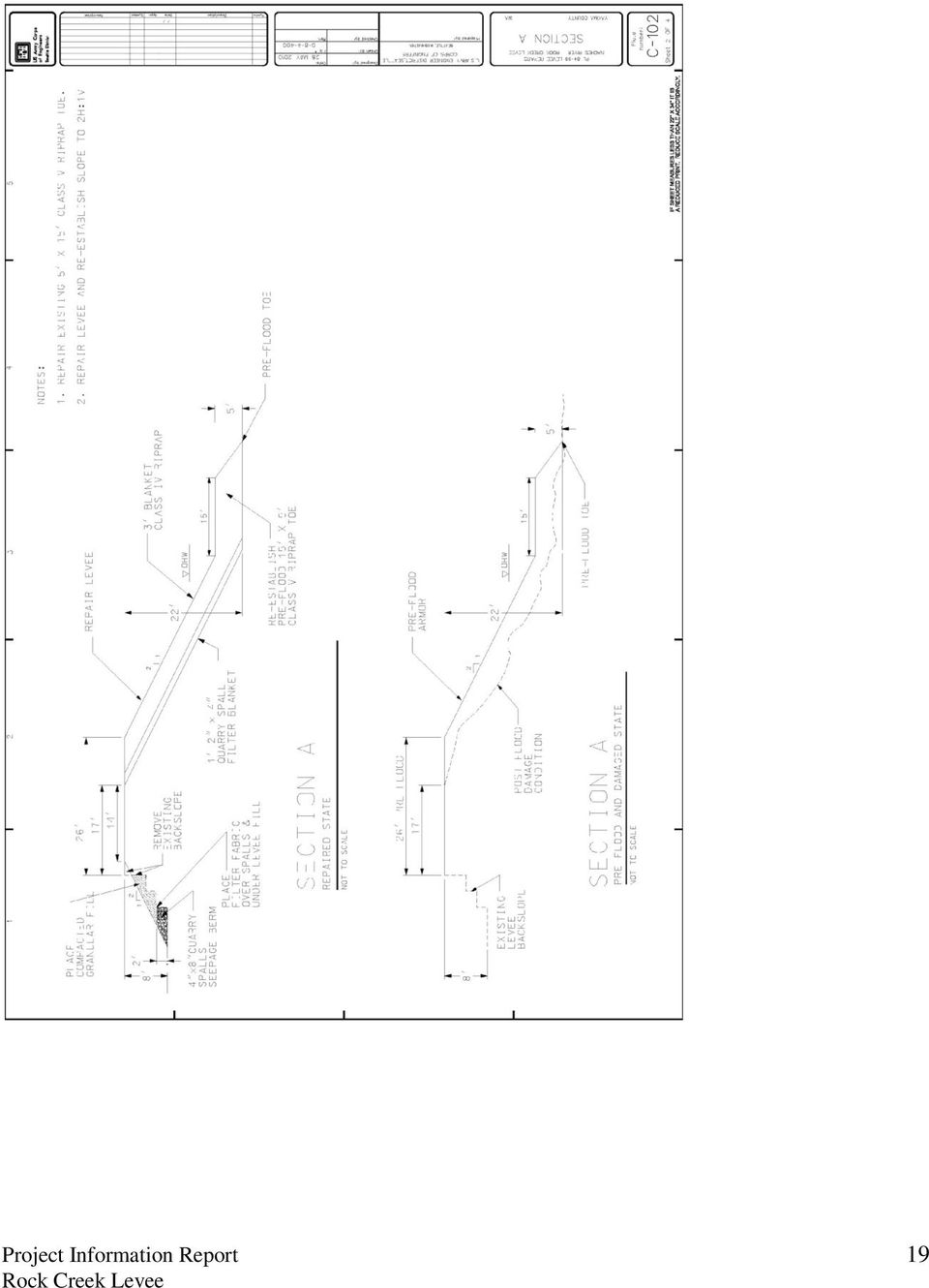
2 PROJECT INFORMATION REPORT REHABILITATION OF FLOOD CONTROL WORKS ROCK CREEK LEVEE NAC-2-09 EXECUTIVE SUMMARY PROJECT NAME: PROJECT FUNDING CLASS: 320 PROJECT CWIS NUMBER: NON-FEDERAL SPONSOR: Yakima County LOCATION AND DESCRIPTION: This non-federal flood control project is located on the left bank of the Naches River near the community of Rock Creek, Yakima County, Washington. The provides 30-year level of protection. The current levee alignment is 1,600 feet in length. Rock Creek enters the Naches River at approximately river mile The levee has a 12 foot (typical) top width and 2H:1V typical sideslopes armored with class IV riprap. A 5 ft. X 15 ft. toe exists along the length of the levee. The levee protects residences and outbuildings, commercial structures, utilities, the local fire station, and State Highway 410. DESCRIPTION OF DAMAGE: During the January 2009 flood event, the Naches River exceeded flood stage and high velocity flows caused damages from flooding including excessive toe scour, riprap armor and levee embankment damages leaving an oversteepened slope with loss of armor protection and damaged toe along the levee alignment. Seepage through the levee was encountered along a 150 ft. reach approximately 150 ft. downstream of the levee s upstream end. In the current damaged state, the levee offers only annual level of protection. PROPOSED REPAIR: The recommended alternative is the Repair In-Kind with Partial Setback alternative. The recommended repair would re-establish the levee toe along the alignment, replace the riverward slope to 2H:1V along the length of the levee, and repair the 5 ft. x 15 ft. class V toe and class IV riprap armor lost during the high water event. All existing materials will be incorporated into the final repair. Additionally a seepage berm will be constructed at station (sta) 1+50 to sta 3+00 (approx.). A 400 ft. section of the levee will be set back from sta to sta (approx.). The levee breached at station and is the current outflow of Rock Creek. The downstream end of the levee will be established at this location and the section of the levee downstream of Rock Creek s current outflow will be abandoned. Repairs will return the Rock Creek levee to its pre-flood level of protection. Project Information Report 1

3 SUMMARIZED FINANCIAL AND ECONOMIC DATA: Total Construction subtotal $ 268,000 S&A (6% of construction subtotal) $ 16,000 Contingency (10% of construction subtotal) $ 27,000 Total Construction Cost $ 311,000 Engineering and Design (6% of total construction) (Federal Cost) $ 19,000 Total Project Costs $ 330,000 Federal Project Cost (80% + E&D) $ 268,000 Sponsor Project Cost (20%) $ 62,000 B/C ratio 7 to 1 POINT OF CONTACT: Doug Weber, CENWS-OD-EM, (206) Project Information Report 2
 $ 62,000 B/C ratio 7 to 1 POINT OF CONTACT: Doug Weber, CENWS-OD-EM, (206) 764-3406 Project Information")
4 PROJECT REPORT 1. Project Identification a. Project Name: b. Project Funding Class: 320 c. Project CWIS Number: Project Authority a. Classification: Non-Federal b. Authority: NA c. Estimated original cost of project: $831,000 d. Construction completion date of the original project: Unknown e. Additional information regarding major modifications/improvements/betterments: None. f. The levee was previously repaired in 1996 and an initial repair in April Public Sponsor a. Sponsor Identification: Yakima County POC for Yakima County: Terry Keehnan Yakima County Public Works Yakima County Courthouse 128 N 2 nd Street, Room 408 Yakima, WA b. Application for Assistance: (1) Date of Issuance of District s Public Notice: 13 January 2009 (2) Date of Public Sponsor s written request (see Appendix A): 27 January Project Location a. County: Yakima State: Washington Basin: Yakima River: Naches River Mile: 33.0 River Bank: Left b. The is adjacent to the Naches River near the community of Rock Creek, Washington. This levee system provides the only means of flood control protection for the adjacent homes, businesses, infrastructure and utilities, and Highway 410. Highway 410 is the only access for the town of Rock Creek during the winter when Chinook Pass is closed. Additional information REPORT PURPOSE: This report provides pertinent information regarding the project, the repair plan, estimated quantities, costs and benefit ratios to restore the existing levees to pre-flood Project Information Report 3

5 condition. Due to the dynamic process of rivers, damages induced by rivers on levees and other structures continuously change. Information including project description, final repair actions contained within this document is subject to change without notice prior to construction. 5. Project Design This non-federal urban levee was constructed to provide flood control protection from periodic recurring flooding from the Naches River near the community of Rock Creek, Yakima County, Washington. This levee is located on the left bank of the Naches River near the community of Rock Creek, Yakima County, Washington. Rock Creek enters the Naches River at approximately river mile The levee has a 12 foot typical top width and 2H:1V typical sideslopes armored with class IV riprap. A 5 ft. X 15 ft.class V toe exists along the length of the levee. The current levee is approximately 1,600 feet in length. Prior to the flood, the levee provided a 30-year level of protection, but now offers annual level of protection. 6. Disaster Incident During January 2009, rainfall and rapid snowmelt resulted in a major flood event on the Naches River. For more information on the flood event, see Seattle District s EngLink Situation Reports for flood event #3. 7. Project Damages During the January 2009 flood event, the Naches River exceeded flood stage and high velocity flows caused damages from flooding including excessive toe scour, riprap armor and levee embankment damages leaving an oversteepened slope with loss of armor protection and damaged toe along the levee alignment. Seepage through the levee was encountered along a 150 ft. reach approximately 150 ft. downstream of the levee s upstream end. In the current damaged state, the levee offers only annual level of protection. 8. Project Performance Data a. Inspection Results. (1) Date of last inspection: June 2008 (2) Type of last inspection: Continuing Eligibility Inspection (CEI) (3) Project condition code of last inspection: Minimally Acceptable (4) Status: Eligible b. Sponsor s Annual O&M Costs: Yakima County dedicates approximately $3,000 in annual maintenance for this levee. The levee is maintained with periodic vegetation cutting, gravel placement, and pre- and post-flood inspections to repair minor damages. The level of maintenance is consistent with Seattle District recommendations. There are no maintenance deficiencies. c. Estimated Cost to Repair Maintenance Deficiencies: No maintenance deficiencies identified. Project Information Report 4

6 9. Project Alternatives Considered Multiple alternatives were considered including the No-Action, Repair In-Kind, Repair In-Kind with Partial Setback, and Non-Structural alternatives. A preliminary analysis has been performed on the following alternatives: a. No-Action Alternative The no action alternative was rejected due to the high likelihood of failure of the levee with the occurrence of even an annual flood event. The results of a failure would include damages to homes, business and infrastructure including Highway 410. b. Repair In-Kind Alternative This alternative was the preliminarily recommended alternative however was dropped once in was determined that a partial setback would be more environmentally advantageous. Repairs to the Rock Creek levee will restore the 30-year level of protection that pre-existed the flood event. c. Repair In-Kind plus Partial Setback Alternative This alternative was evaluated and selected as the preferred alternative. The initial repair in April 2009 provides protection for the spring flood season. Permanent repairs will reestablish reliable flood protection for the future flood seasons, and restore the 30-year level of protection that existed prior to the flood event. A portion of the levee from Sta to Sta will be setback. The downstream end of the levee will be established at approximately sta , Rock Creek s current outflow. d. Non-Structural Alternative This alternative would relocate all existing structures, utilities and other infrastructure within the damage area protected by this section of levee. This was not a viable alternative for our sponsor. The costs associated with this alternative were deemed too high for the level of benefit associated with this alternative. 10. Recommended Alternative The recommended alternative is repair in-kind plus partial setback. The initial repairs in April 2009 provided protection for the spring flood season. Permanent repairs will re-establish reliable flood protection for the future flood seasons, and restore the 30-year level of protection that existed prior to the flood event. A portion of the levee from Sta to Sta will be setback. The downstream end of the levee will be established at approximate sta , Rock Creek s current outflow. The local sponsor prefers the partial setback alternative. 11. Lands, Easements, Rights-of-Way, Relocations, and Disposal areas (LERRD) The Repair is located on the left bank of the Naches River in Section 17, Township 16 North, Range 15 East, Willamette Meridian, in Yakima County, Washington. The Project Information Report 5

7 levee repair will set back a portion of the existing levee prism and return the levee project to its pre-flood level of protection (See, Appendix B Project Drawings). Acquisition of additional perpetual property interests will be required if the proposed repair footprint exceeds the area covered by the Public Sponsor s existing perpetual easements, or if the existing easements do not provide the required interests in project lands. In order to proceed with the levee repair, the Public Sponsor must make the required project lands available prior to solicitation for the construction contract. See the proposed project schedule under Section 15 of this report. To meet the real estate requirements for the Rehabilitation Effort, the Public Sponsor will need to demonstrate that it has the real property interests listed below: PERPETUAL FLOOD PROTECTION LEVEE EASEMENT ESTATE A perpetual and assignable right and easement in the land delineated on the attached location map, Exhibit A, by this reference made a part hereof, to construct, maintain, repair, operate, patrol and replace a flood protection levee, including all appurtenances thereto; reserving, however, to the owners, their heirs and assigns, all such rights and privileges in the land as may be used without interfering with or abridging the rights and easement hereby acquired. Proposed access (both ingress and egress) to the Project footprint is available over private lands from SR-410, a public road right-of-way (See project map). Access will need to be provided at the upstream end of the project to accomplish repair work. The Public Sponsor will need to demonstrate that it has the below real property interests for perpetual access to the levee easement footprint from the SR-410 public right-of-way. PERPETUAL ROAD EASEMENT A perpetual and assignable easement and right-of-way in, on, over and across the land delineated on the attached location map, Exhibit A, for the location, construction, operation, maintenance, alteration and replacement of (a) road(s) and appurtenances thereto; together with the right to trim, cut, fell and remove there from all trees, underbrush, obstructions and other vegetation, structures, or obstacles within the limits of the right-of-way; reserving, however, to the grantors, their heirs and assigns, the right to cross over or under the right-ofway as access to their adjoining land; subject, however, to existing easements for public roads and highways, public utilities, railroads and pipelines. Construction staging will occur within the perpetual levee easement footprint. The need for additional temporary staging areas is being considered. If it is later determined that a temporary construction staging area, or temporary access road is required for construction, the Public Sponsor will need to demonstrate that it has the below real property interests for those areas. TEMPORARY WORK AREA EASEMENT A temporary easement and right-of-way in, on, over, and across the land delineated on the attached location map, Exhibit A, for a period not to exceed twelve (12) months, beginning with date possession of the land is granted to the Grantee for use by the United States, its Project Information Report 6

8 representatives, agents, and contractors as a work area, including the right to deposit fill material thereon, move, store, and remove equipment and supplies, and erect and remove temporary structures on the land and to perform any other work necessary and incident to the construction of the Rehabilitation Effort, Job No. NAC-2-09, together with the right to trim, cut, fell, and remove there from all trees, underbrush, obstructions, and any other vegetation, structures, or obstacles within the limits of the right-of-way; reserving, however, to the landowners, their heirs and assigns, all such rights and privileges as may be used without interfering with or abridging the rights and easement hereby acquired; subject, however to existing easements for public roads. The final location of temporary access routes and temporary disposal sites will be determined in the next project phase E&D. If the COE, Real Estate Division determines the Public Sponsor does not have adequate real property interests for the lands needed for the proposed Rehabilitation Effort, including additional damage not visible at the time of inspection because of the presence of vegetation, then acquisition of property interests may be necessary. The need for the Public Sponsor to acquire or cure its existing property interests could result in further delay of repairing the damaged levee as proposed in the project schedule see Section 15 of this report. As part of the land certification process for the Rehabilitation Effort, the Public Sponsor will need to provide title reports not more than 90 days-old at the time of land certification demonstrating its real property interests in the lands required for the proposed levee repairs. Any questions regarding types of property interests needed for the proposed project should be coordinated with COE, Real Estate Division. 12. Economic Evaluation In preparing a cost and benefit feasibility assessment for any emergency project the Chief of Engineers shall consider the benefits to be gained by such a project for the protection of residential establishments, commercial establishments to include the protection of inventory, and agricultural establishments to include the protection of crops. The benefit-to-cost ratio (BCR) must be greater than 1.0 for the rehabilitation to be justified. Benefits attributable to the proposed levee repair are calculated on the difference in probabilities associated with the Level of Protection (LOP) provided by the levee in the repaired condition compared to the damaged or post event condition. The benefits of project rehabilitation are determined by comparison of with and without project conditions. The economic analysis will be prepared in level of detail commensurate with the complexity of the project. It is not intended that the analyses for rehabilitation projects be exhaustive, but should provide sufficient data to estimate the benefits of each plan in order to support the plan formulation process. With repair, the levee will be restored to a 30-year LOP. In accordance with EP , the economic life applicable to non-federal urban levees shall be 50 years, or the degree of protection afforded by the project, whichever is less. Therefore, the following economic analysis is based on an economic life of 30 years. Prior to the flood event, this levee provided protection Project Information Report 7

9 from floods with a greater 30-year recurrence interval. The recent high water event caused damages to the levee that degraded the LOP to offering 1-year protection, meaning damages are likely with a return period greater than the annual flood event. There are numerous parcels of land and structures in the community protected by this levee, including residences, businesses, the Rock Creek Fire Station and Highway 410. An evaluation of the parcels in the immediate vicinity of the flood plain covered a little over 70 acres and showed 17 structures with a total depreciated replacement value of approximately $872,000. Since the without-project condition is expected to provide protection from flooding from an annual event, the zero-damage event is equivalent to the without-project level of protection of 1 year. We will also assume that a 2-year event would cause significant damage and flood these structures with at least 1 foot of water. A 30-year event is expected to inundate the floodplain with three to four feet of water; it is assumed that a 30-year event would flood all of the structures with at least 3.5 feet of water. Based on standard depth-damage curves, Table 1 shows the expected damages from the 2-year and 30-year events. Table 1: Estimated Event Damages Event Annual Exceedence Frequency Inundation Depth Estimated Damages (Content & Structure) 1-year 100% year 50% 1 $124, year 3.33% 3.5 $409,000 If the levee is not repaired the expected annual damages (EAD) to the 17 structures and their contents are approximately $169,000. The EAD is the probability weighted sum of damages from the without-project level of protection event (1-year) to the with-project level of protection (a 30-year event). With repair the EAD is approximately $14,000. Therefore the approximate EAD of at least $155,000 in damages are considered as preventable with rehabilitation and taken as benefits. The annual benefits for repair of the levee are the annual damages reduced by restoring the level of protection to the 30-year level that existed before the damage was incurred. Annual benefits are the difference between the with- and without-project EAD. Table 2 shows the with- and without-project EAD and the resulting expected annual damages reduced or benefits for restoring the level of protection to the levee, based on this sample of structures and damages. Since the project does not provide protection for events that exceed the 30-year recurrence interval, additional damages were not estimated and are assumed to remain the same. Table 2:Estimated Annual Project Benefits Without-Project EAD $169,000 With-Project EAD $14,000 EAD Reduced (Annual $155,000 Benefits) The total estimated project costs including real estate to restore 30-year protection to the levee are $330,000. These costs are annualized at the FY10 discount rate of 4 3/8 percent over the 30- Project Information Report 8

10 year period of analysis. Table 3 displays the total project costs, annualized costs, and resulting benefit-to-cost ratio (BCR). Table 3: Annualized Costs and Benefit-Cost Ratio First Cost $330,000 Annual Cost Principle and Interest ( %) $19,000 O&M $3,000 Total Annual Cost $22,000 Total Annual Benefit (EAD Reduced) $155,000 Benefit-Cost Ratio 7 to 1 The following checks were performed: Benefit Check 1. First costs do not exceed property value Property value: $872,000 First costs: $327, Crop benefits per acre do not exceed 5% of land value per acre 3. Crop benefits do not exceed net crop income 4. Each property owner accounts for less than 25% of the benefits Check met? Yes Not applicable Not applicable The protected area is owned by at least 15 individuals. No individual receives more than 25% of the benefits. 13. Environmental The portion of the Naches River comprising the project area includes a single channel, approximately 150 feet in width, bounded by a levee on the left bank which protects residential structures, outbuildings, commercial structures, infrastructure including utilities, a fire station, and Hwy The right bank is a rock face. The upstream end of the levee is at Highway 410 approx. RM 33.5 and continues downstream for approximately 1,600 ft. Prior to the 2009 flood, Rock Creek had approached flowed parallel to the levee for a short distance before turning southeast, flowing along the highway, and entering the Naches River a distance below the downstream end of the levee. During the 2009 flood event, approximately 550 LF of the lower section of the levee was breached and lost. Rock Creek currently flows into the Naches River at this breach. Project Information Report 9

11 The Naches River in the vicinity of the project area provides migratory, foraging, and rearing habitat for most of the fish species that utilize the river and upstream tributaries, as well as habitat for a diversity of other aquatic and terrestrial species. Salmonid species in the project vicinity include bull trout and steelhead, both of which are listed species. The recommended alternative includes the abandonment of the lower section of the levee and a partial setback of the middle section of the levee. Both of these will benefit the local environment. The abandonment of the lower section of the river will allow natural riverbank formation and increase the amount of vegetation along the banks to improve shoreline habitat for protected salmonids. It also decreases the impacts that would occur in repairing the breach by returning the confluence of Rock Creek to its pre-flood channel, and allows the natural meandering of the river and this creek through this area. By setting back the middle portion of the levee this is expected to decrease the frequency of future repairs, thus decreasing the cumulative impact of the levee by limiting future turbidity increases, temperature increases, and vegetative disturbance from construction. The setback will also allow for space in front of the levee that could revegetate naturally without endangering the integrity of the levee and without the need for continued maintenance. Overhanging vegetation along the river increases habitat function for salmonids and other fish by increasing nutrient input, shade, and creating refugia during high water events. Potential Issues: a. Water Quality. There may be a temporary increase in turbidity due to construction and fill placement. Turbidity will be monitored during construction. If turbidity exceeds water quality maximum standards, construction will be halted, and will recommence when turbidity returns to acceptable levels. Some loss of stream bank habitat complexity, grassy vegetation, and organic matter inputs into Rock Creek and/or Naches River may occur. b. Endangered Species Act: The following species listed as endangered (E) or threatened (T) and their critical habitat (CH) are found in the project area: Steelhead (T) (CH) Bull trout (T) (CH) Bull trout and steelhead are known to occur in the Naches River. The project area contains prime habitat for listed bull trout and listed steelhead which are known to be present in the construction area. The steelhead spawning season runs from late February through May. Juvenile steelhead will emerge from redds starting in July. There are approximately steelhead trout in the system so an impact to the fish (at any life stage) or their habitat is very critical. The river area adjacent to the proposed repairs consists of spawning gravels and deep pools. Steelhead spawning and bull trout migration occur here. Spawning redds survive all but the most severe flood flows (Scott Hoefer NMFS pers. comm.). Any in-water construction will occur within the approved fish window (June 1 August 15) using best management practices to limit impacts. The partial setback will provide more high water refuge for species Project Information Report 10

12 during high water events. Narrowing the toe placement in areas where there are deep pools will reduce impacts to the aquatic habitat. Although bald eagle was delisted on June 28, 2007, they continue to be protected by the Migratory Bird Treaty Act and the Bald and Golden Eagle Protection Act. These acts require some measures to continue to prevent bald eagle take resulting from human activities. Additional guidance regarding these requirements is available at the time of this writing from Any potential effects of the proposed work on threatened or endangered species and designated critical habitat will be addressed in separate compliance documentation in accordance with Section 7 of the Endangered Species Act. When completed, this levee repair is not intended or expected to generate appreciable change in habitat conditions as compared with conditions pre-existing the flood event. Repair construction work may result in short-term impacts to fish and wildlife. If present, adult and juvenile salmonids may be temporarily displaced from the project area. Construction noise may temporarily disturb any wildlife in the project area. Long-term effects will include greater conveyance of the river and greater access to floodplain due to the setback of the levee from the river. c. Wetlands. The proposed project will be constructed to avoid impacts to wetlands. The construction work will occur within the footprint of the pre-existing levee, with the exception of the partial setback. Construction access and staging areas will be along the existing levee. The levee setback and repair will be constructed to avoid wetland impacts. Delineation will be necessary to define any potential wetland impacts. The setback and potential wetland impacts have been discussed with the Department of Ecology and it is anticipated that the benefits of the setback will outweigh the wetland loss. Further impact analysis, consideration of mitigation for any wetland loss, and coordination will occur during the E&D phase. d. Cultural Resources. The proposed site is within an area of high probability of historical importance to the Yakama Nation. The Corps has initiated consultation with the Washington State Historic Preservation Officer and the Yakama Nation. Should earth disturbing activities penetrate native sediments below or beside the existing, an on-site professional archaeological monitor needs to be present. The affected tribes may ask to be notified prior to construction in the event they may want to witness the work. Prior to repairs, a Corps archeologist will conduct a cultural resources survey of the project area to determine whether there is a potential for the proposed repairs to cause effects to historic properties. National Historic Preservation Act Section 106 compliance reports will be prepared for all proposed repairs. The report will include the findings of the investigations for each repair site, recommendations for archaeological monitoring during construction, and a determination of effects to archaeological and historic properties. If archaeological monitoring is recommended at some repair locations, the report will include a monitoring plan and protocols to be followed. The protocols will include an inadvertent discovery clause that will Project Information Report 11

13 apply when an archaeological monitor is not present. The Corps determinations of effects to historic properties, the investigation report, and monitoring plan will be reviewed and approved by the Washington State Historic Preservation Officer (SHPO) and the appropriate tribes prior to construction. e. Recreation. This section of levee is not considered a recreational area. f. Cumulative Effects. Cumulative effects will be addressed as required pursuant to NEPA and ESA. g. Coordination. The proposed work is formally coordinated throughout the planning, design, and construction phases with the following agencies: (1) U.S. Fish and Wildlife Service; (2) NOAA Fisheries; (3) Environmental Protection Agency; (4) Washington Department of Fish and Wildlife; (5) Washington Department of Ecology; (6) Yakama Nation; (7) State Historic Preservation Office. Their recommendations will be considered and implemented as appropriate. The design will be coordinated with and reviewed by the above listed agencies. In accordance with ER , Procedures for Implementing NEPA, paragraph 8, Emergency Actions, and the environmental effects of the proposed levee rehabilitation will be considered during the planning process. An environmental assessment (EA) will be prepared to evaluate probable impacts of the project on the existing environment. Factors addressed by the evaluation will include, but will not be limited to, public safety, water quality, wetlands, threatened and endangered species, noise, air quality, cultural resources, economics, fish, and wildlife. The EA will be coordinated with applicable Federal and State resource agencies. The NEPA process will conclude prior to construction pursuant to requirements in ER The proposed levee repairs would not be the first repair to this particular levee. Accordingly, cumulative impacts of the past, proposed, and reasonably foreseeable future projects in the area will likely be important considerations in the NEPA and ESA documentation. In addition, requirements for compliance with the Endangered Species Act will be completed. According to Title 33 Code of Federal Regulations, Section 323.4(a)(2), emergency reconstruction of recently damaged parts of levees does not require a Section 404 evaluation provided that the work does not include any modification that changes the character, scope, or size of the original fill design. The proposed repair includes a partial setback along a new alignment, and repairs along the original levee alignment. The levee repair and setback will be constructed to avoid wetland impacts. It is expected that a Sec. 404(b) (1) evaluation and a Sec. 401 water quality certification from Ecology may be required. h. Environmental enhancement features. Project construction will include environmental enhancement features to offset temporary construction impacts. Environmental features Project Information Report 12

14 proposed by agencies during NEPA coordination will be fully reviewed and engineered during E&D. Environmental enhancements could include removal of invasive species from the project area, partial levee setback, and placement of topsoil over disturbed areas including the levee face to OHW, and hydroseeding disturbed areas with native grasses. 14. Interagency Levee Task Force HQUSACE has not directed activation of an Interagency Levee Task Force for this flood event. However, informal coordination with FEMA is ongoing. 15. Project Management a. Funding Authority (1) Program and Appropriation: 3125 (2) Project Funding Class: 320 (3) Project CWIS Number: c. Project Funds: Project Cost Estimate The cost estimate is presented by the details of each damage site first, followed by a project summary table that adds supervision and administration (S&A), contingency, and engineering and design (E&D). Project Information Report 13
 Program and Appropriation: 3125 (2) Project Funding Class: 320 (3) Project CWIS Number: 322468 c.")
15 Table 1 - Project Cost Estimate Total Construction subtotal $ 268,000 S&A (6% of construction subtotal) $ 16,000 Contingency (10% of construction subtotal) $ 27,000 Total Construction Cost $ 311,000 Engineering and Design (6% of total construction) (Federal Cost) $ 19,000 Total Project Costs $ 330,000 Federal Project Cost (80% + E&D) $ 268,000 Sponsor Project Cost (20%) $ 62,000 B/C ratio 7 to 1 c. Project Repair Schedule The Work Window (work allowed in the water) is 1 June to 15 August. Work performed outside this window will only consist of work that is not in the water. Table 2 - Project Repair Schedule RESPONSIBLE PARTY MILESTONE TASKS MILESTONE DATE COE PIR Approval 15 July 2010 COE E&D complete 11 December 2011 COE CA and Designs to Public sponsor for 05 January 2011 Review NLT COE LER cert to Public sponsor based on 19 January 2011 confirmed footprint Yakima County Sign CA by Public sponsor 14 February 2011 COE EA/FONSI 11 March 2011 Yakima County Public sponsor certifies lands 15 March 2011 Yakima County Public sponsor provides cash contribution 15 March 2011 COE RE Division Certifies Lands Available 17 April 2011 COE Solicit contractors 15 May 2011 COE Initiate (rental equipment) construction 1 June 2011 COE In-Water Construction Complete 1 July 2011 COE Complete Construction 15 July 2011 d. Project Authentication Project Management...Brian Nelson...(206) Emergency Management approval...doug Weber...(206) e. Technical Points of Contact Project Information Report 14

16 Emergency Management...Doug Weber...(206) Economics...Scott Long...(206) Environmental...Bobbi Jo McClain...(206) Jeff Laufle...(206) Cultural Resources...Danielle Storey...(206) Engineering and Design...Cathie DesJardin...(206) Program Management...Amanda Ogden...(206) Real Estate...Kevin Kane...(206) Hydraulics and Hydrology...Travis Ball...(206) Project Information Report 15
 764-3628 Real Estate...Kevin Kane...(206) 764-6652 Hydraulics and Hydrology...Travis Ball.")
17 APPENDICES Appendix A: Project Sponsor s request for Rehabilitation Assistance Project Information Report 16

18 Appendix B: Project location and design data, maps, and related information Project Information Report 17

19 Project Information Report 18

20 Project Information Report 19
Gold Ray Dam Interagency Technical Team Meeting
 Gold Ray Dam Interagency Technical Team Meeting Agenda Public Outreach, Funding, Monitoring EA/BA/Permit Updates Deconstruction Plans Fish Passage & Salvage Plan Hydraulic Modeling Next Steps Public Outreach,
Public Law 84-99 and Non-Structural Alternatives to Levee Repairs
 Public Law 84-99 and Non-Structural Alternatives to Levee Repairs Presented by: Mr. Jerry A. Skalak, CFM U.S. Army Corps of Engineers Rock Island District and Mr. Tom Oswald Iowa Homeland Security and
PERPETUAL STORM DAMAGE REDUCTION EASEMENT Pre-Existing Structure. THIS PERPETUAL STORM DAMAGE REDUCTION EASEMENT is made BY AND BETWEEN.
 PERPETUAL STORM DAMAGE REDUCTION EASEMENT Pre-Existing Structure THIS PERPETUAL STORM DAMAGE REDUCTION EASEMENT is made BY AND BETWEEN residing at herein after referred to as Grantor, AND Suffolk County
DRAFT SOUTH FORK SKYKOMISH RIVER
 DRAFT SOUTH FORK SKYKOMISH RIVER 9 levees and revetments / Approximately 1.1 miles of river bank are armored Revetments provide limited, localized erosion protection, but impact habitat Frequent and costly
BEACH STORM DAMAGE REDUCTION EASEMENT
 STATE OF FLORIDA COUNTY OF WALTON WALTON COUNTY, FL HURRICANE & STORM DAMAGE REDUCTION PROJECT FILE/REACH#: PARCEL ID#: BEACH STORM DAMAGE REDUCTION EASEMENT KNOW ALL MEN BY THESE PRESENTS, that for and
PUBLIC NOTICE Application for Permit
 PUBLIC NOTICE Application for Permit 30-Day Notice Issue Date: June 20, 2016 Expiration Date: July 20, 2016 US Army Corps of Engineers No: NWP-2010-535 Oregon Department of State Lands No: 58311-RF Interested
Flood Risk Management
 Flood Risk Management Value of Flood Risk Management Every year floods sweep through communities across the United States taking lives, destroying property, shutting down businesses, harming the environment
Flood Risk Management
 Flood Risk Management Value of Flood Risk Management Value to Individuals and Communities Every year floods sweep through communities across the United States taking lives, destroying property, shutting
The answers to some of the following questions are separated into two major categories:
 Following the recent flooding events for Front Range communities in Colorado, property owners, communities, and the National Flood Insurance Program are being presented with some new challenges in the
The Basics of Chapter 105 Waterways and Wetlands Permitting in PA
 The Basics of Chapter 105 Waterways and Wetlands Permitting in PA April 17, 2013 Goal To develop a basic understanding of PA Department of Environmental Protection (DEP) and US Army Corps of Engineers
FLOOD PROTECTION BENEFITS
 IV. (340 points) Flood Protection Benefits A. Existing and potential urban development in the floodplain (50) 1. Describe the existing and potential urban development at the site and the nature of the
March 2008. Prepared by: Irvine Ranch Water District. 15600 Sand Canyon Avenue. Irvine, CA 92618. Contact: Natalie Likens (949) 453-5633
 453-5633") ADDENDUM TO THE MICHELSON WATER RECLAMATION PLANT PHASE 2 & 3 CAPACITY EXPANSION PROJECT FEBRUARY 2006 FINAL ENVIRONMENTAL IMPACT REPORT AND THE SAN JOAQUIN FRESHWATER MARSH ENHANCEMENT PLAN REVISED SEPTEMBER
ADDENDUM TO THE MICHELSON WATER RECLAMATION PLANT PHASE 2 & 3 CAPACITY EXPANSION PROJECT FEBRUARY 2006 FINAL ENVIRONMENTAL IMPACT REPORT AND THE SAN JOAQUIN FRESHWATER MARSH ENHANCEMENT PLAN REVISED SEPTEMBER
Swannanoa River Flood Risk Management Study
 Swannanoa River Flood Risk Management Study Measures Evaluated to Reduce Future Flood Damages City of Asheville U.S. Army Corps of Engineers Flooding History Part of the 132 square mile Swannanoa River
Appendix C. Project Opportunities. Middle Twisp River (RM 7.8 18.12)
") Appendix C Project Opportunities Middle Twisp River (RM 7.8 18.12) This table describes project opportunities by project area. Locator maps of the project opportunities are included below the table. Reach
Appendix C Project Opportunities Middle Twisp River (RM 7.8 18.12) This table describes project opportunities by project area. Locator maps of the project opportunities are included below the table. Reach
Appendix F Benefit-Cost Analysis of Flood Protection Measures
 Appendix F Benefit-Cost Analysis of Flood Protection Measures Acronyms used in Appendix F: AA B AA C AA D BC BFE EAD FEMA NED O&M PV RED USACE Average Annual Benefits Average Annual Cost Average Annual
Chapter 3 SENSITIVE AREAS AND VEGETATED CORRIDORS
 Chapter 3 3.01 General Provisions 3.01.1 Introduction 3.01.2 Application and Interpretation of Chapter 3.01.3 Unbuildable Lots 3.01.4 Other Permits 3.01.5 Prohibited Activities 3.02 Service Provider Letter
30-DAY PUBLIC NOTICE CHELSEA RIVER, EAST BOSTON MASSACHUSETTS EMERGENCY STREAMBANK PROTECTION PROJECT
 PUBLIC NOTICE Engineering/Planning 696 Virginia Road Concord, MA 01742 Date: 10 November, 2015 Comment Period Ends: 10 December, 2015 In Reply, Refer To: Robert Russo Or by e-mail: Robert.S.Russo@usace.army.mil
1.7.0 Floodplain Modification Criteria
 1.7.0 Floodplain Modification Criteria 1.7.1 Introduction These guidelines set out standards for evaluating and processing proposed modifications of the 100- year floodplain with the following objectives:
Prattsville Berm Removal Project. 1.0 Project Location
 Prattsville Berm Removal Project 1.0 Project Location The project site is located between the New York State Route 23 Bridge over the Schoharie Creek and the Schoharie Reservoir. The restoration plan encompassed
Proposal to the Trinity Adaptive Management Working Group (TAMWG)
") Proposal to the Trinity Adaptive Management Working Group (TAMWG) Request that the TAMWG recommend that the Trinity River Restoration Program fund BLM to purchase the Weigel parcel at Gold Bar (river mile
Proposal to the Trinity Adaptive Management Working Group (TAMWG) Request that the TAMWG recommend that the Trinity River Restoration Program fund BLM to purchase the Weigel parcel at Gold Bar (river mile
FINAL TECHNICAL MEMORANDUM AWD-00002 FLOWS THROUGH FLOOD DAMAGE REDUCTION AREA July 16, 2012
 FINAL TECHNICAL MEMORANDUM AWD-00002 FLOWS THROUGH FLOOD DAMAGE REDUCTION AREA July 16, 2012 Table of Contents TABLE OF CONTENTS Table of Contents... 1 Executive Summary... 2 1 Objective... 4 2 Study Approach...
Mission Creek Flood Control & Restoration Project. City of Fremont, Alameda County
 Mission Creek Flood Control & Restoration Project City of Fremont, Alameda County Agenda Background Why are proposed improvements necessary? Proposed project components Challenges Construction schedule/phasing
King County Flood Hazard Management Plan Update Cedar/ Sammamish Rivers. Public Meeting December 5, 2012
 King County Flood Hazard Management Plan Update Cedar/ Sammamish Rivers Public Meeting December 5, 2012 Goals of the Presentation Cedar and Sammamish R. Plan Update Context - Brief summary info about the
APPENDIX 9-1 Project 1: City of Lompoc, Lompoc Valley Leak Detection and Repair Project
 APPENDIX 9 APPENDIX 9-1 Project 1: City of Lompoc, Lompoc Valley Leak Detection and Repair Project This project does not require an appendix to this attachment. APPENDIX 9-2 Project 2: City of Santa Maria,
ECONOMIC ANALYSIS FLOOD DAMAGE REDUCTION. Lower Carmel River Floodplain Restoration and Enhancement Project
 ECONOMIC ANALYSIS FLOOD DAMAGE REDUCTION Lower Carmel River Floodplain Restoration and Enhancement Project I. Description of the Project and its Relationship to Other Projects in the Proposal The Lower
COMPLIANCE REPORT MUDDY HOLLOW CULVERT REMOVAL FILE NUMBER 25358N
 COMPLIANCE REPORT MUDDY HOLLOW CULVERT REMOVAL FILE NUMBER 25358N Submitted by the National Park Service Point Reyes National Seashore Point Reyes Station, California, 94956 Project Description: Muddy
Environmental Compliance Questionnaire for National Oceanic and Atmospheric Administration Federal Financial Assistance Applicants
 OMB Approval No.: 0648-0538 Environmental Compliance Questionnaire for National Oceanic and Atmospheric Administration Federal Financial Assistance Applicants Instructions The National Environmental Policy
Steelhead Recovery in San Juan and Trabuco Creeks Watershed
 Steelhead Recovery in San Juan and Trabuco Creeks Watershed Are there fish now? Overview Final San Juan and Trabuco Creeks Watershed Management Plan Fish & Game Implementation NOAA Steelhead Recovery and
Assessment of Conceptual Nonstructural Alternative Levee Setbacks along the Missouri River (Lower L-575 / Upper L-550 and Lower L-550)
") Assessment of Conceptual Nonstructural Alternative Levee Setbacks along the Missouri River (Lower L-575 / Upper L-550 and Lower L-550) Final Report April 2012 Executive Summary The authorities of Public
Assessment of Conceptual Nonstructural Alternative Levee Setbacks along the Missouri River (Lower L-575 / Upper L-550 and Lower L-550) Final Report April 2012 Executive Summary The authorities of Public
Restoring Anadromous Fish Habitat in Big Canyon Creek Watershed. Summary Report 2002
 Restoring Anadromous Fish Habitat in Big Canyon Creek Watershed Summary Report 2002 DOE/BP-00005268-5 November 2002 This Document should be cited as follows: "Restoring Anadromous Fish Habitat in Big Canyon
AN INITIATIVE TO IMPROVE
 L OW E R C A R M E L R I V E R A N D L AG O O N F L O O D P L A I N R E S TO R AT I O N A N D E N H A N C E M E N T P R O J E C T AN INITIATIVE TO IMPROVE FLOOD PROTECTION RESTORE AND PROTECT RIPARIAN
Background Information: The Mamquam River Floodplain Restoration Project
 Background Information: The Mamquam River Floodplain Restoration Project The Mamquam River Floodplain Restoration project is being undertaken in partnership with the Squamish River Watershed Society, Fisheries
Post-Flood Assessment
 Page 1 of 7 Post-Flood Assessment CHAPTER 4 AGENCY COORDINATION Agency coordination is an essential element for the operation of the flood management systems in the Central Valley. Due to the nature of
Rhode Island NRCS received approximately $2.4 million in ARRA funds to implement four floodplain easement projects.
 American Recovery and Reinvestment Act (ARRA) Emergency Watershed Protection Program Floodplain Easements Rhode Island Natural Resources Conservation Service Rhode Island NRCS received approximately $2.4
Adopted 9/23/98 CHATTAHOOCHEE CORRIDOR PLAN. The goals of the Chattahoochee Corridor Plan (hereinafter also referred to as the Plan ) are:
 are:") CHATTAHOOCHEE CORRIDOR PLAN Adopted 9/23/98 PART 1: GOALS. POLICY. COVERAGE. A. Goals The goals of the Chattahoochee Corridor Plan (hereinafter also referred to as the Plan ) are: 1. Preservation and protection
CHATTAHOOCHEE CORRIDOR PLAN Adopted 9/23/98 PART 1: GOALS. POLICY. COVERAGE. A. Goals The goals of the Chattahoochee Corridor Plan (hereinafter also referred to as the Plan ) are: 1. Preservation and protection
Chehalis River Basin Flood Damage Reduction 2013-2015 Capital Budget Approved by Legislature in June 2013
 Chehalis River Basin Flood Damage Reduction 2013-2015 Capital Budget Approved by Legislature in June 2013 1. Design alternatives for large capital flood projects (basinlevel water retention and Interstate
King County, Washington Policies and Practice for the Use of Eminent Domain For Flood Risk Reduction
 King County, Washington Policies and Practice for the Use of Eminent Domain For Flood Risk Reduction Introduction Eminent domain refers to the power possessed by the state over all property within the
30 DAY PUBLIC NOTICE MAINTENANCE DREDGING OF THE FEDERAL NAVIGATION PROJECT IN COHASSET HARBOR COHASSET AND SCITUATE, MASSACHUSETTS
 .-ro:'j - I US Army Corps of Engineers r& New England District 696 Virginia Road Concord, MA 01742-2751 Public Notice In Reply Refer to: Mr. Craig Martin nae-pn-nav@usace.army.mil Programs/Project Management
United States Depmiment of the Interior Bureau of Reclamation Western Colorado Area Office Grand Junction, Colorado
 WCAO-GJ-FONSI -14-01 United States Depmiment of the Interior Bureau of Reclamation Western Colorado Area Office Grand Junction, Colorado FINDING OF NO SIGNIFICANT IMPACT SPURLIN MESA LATERAL OF THE CRAWFORD
Notice of Preparation / Clean Water Act Public Notice
 Notice of Preparation / Clean Water Act Public Notice Environmental and Cultural Public Notice Date: 6 February 2015 Resources Branch Expiration Date: 9 March 2015 P.O. Box 3755 Reference: EN-ER-15-01
CLACKAMAS COUNTY ZONING AND DEVELOPMENT ORDINANCE
 1008 STORM DRAINAGE (3/24/05) 1008.01 PURPOSE To minimize the amount of stormwater runoff resulting from development utilizing nonstructural controls where possible, maintain and improve water quality,
OVERVIEW MIDDLE CREEK FLOOD DAMAGE REDUCTION AND ECOSYSTEM RESTORATION PROJECT October 3, 2012 INTRODUCTION
 OVERVIEW MIDDLE CREEK FLOOD DAMAGE REDUCTION AND ECOSYSTEM RESTORATION PROJECT October 3, 2012 INTRODUCTION The Middle Creek Flood Damage Reduction and Ecosystem Restoration Project (Project) will eliminate
A9. Flood Damage Reduction
 A9. Flood Damage Reduction Attachment 9 identifies the flood damage reduction benefits attributed to the seven projects proposed for implementation in the Santa Barbara County Region Proposition 84 (Prop
San Diego Integrated Regional Water Management Implementation Grant Proposal Economic Analysis Flood Damage Reduction Costs and Benefits
 Attachment 9 San Diego Integrated Regional Water Management Economic Analysis Flood Damage Reduction Costs and Benefits Attachment 9 consists of the following items: Flood Damage Reduction Costs and Benefits.
Addendum D. Nomination of Moody Wash ACEC
 Addendum D Nomination of Moody Wash ACEC Moody Wash ACEC is hereby nominated by Citizens for Dixie s Future to: BLM St. George Field Office 345 East Riverside Drive St. George, UT 84790 Moody Wash is a
DEPARTMENT OF THE ARMY OFFICE OF THE CHIEF OF ENGINEERS WASHINGTON, D.C. Z0314-1000
 DEPARTMENT OF THE ARMY OFFICE OF THE CHIEF OF ENGINEERS WASHINGTON, D.C. Z0314-1000 REPLY TO ATTENTION OF: CECW-PC (l0-1-7a).oi9 MAY 1996. THE SECRETARY OF THE ARMY ". 1. I submit for transmission to Congress
Harris County Flood Control District. Policy, Criteria, and Procedure Manual
 Harris County Flood Control District Policy, Criteria, and Procedure Manual For Approval and Acceptance of Infrastructure General Review October 10, 2003 Draft Please Provide Written Comments to the HCFCD
How To Manage Water Resources In The Yakima Basin
 Yakima Basin Integrated Water Resource Management Plan October 23, 2014 Presented by Derek Sandison, Director Office of Columbia River Photo Courtesy of Tom Ring Basin size: 6,155 sq. miles Population:
UTILITIZATION OF ECOHYDROLOGIC MODELS IN FLOODPLAIN FISH PASSAGE AND HABITAT RESTORATION EVALUATION
 UTILITIZATION OF ECOHYDROLOGIC MODELS IN FLOODPLAIN FISH PASSAGE AND HABITAT RESTORATION EVALUATION Joshua A. Israel, Fish Biologist, U.S Bureau of Reclamation, Sacramento, CA. jaisrael@usbr.gov; Paul
SKAGIT COUNTY HABITAT IMPROVEMENT PLAN
 SKAGIT COUNTY HABITAT IMPROVEMENT PLAN Public Works Department Natural Resources Division August 2012 Mission To create and advance restoration strategies that support Skagit County goals for promoting
Stream Rehabilitation Concepts, Guidelines and Examples. Objectives. Pierre Y. Julien. Three Laws of Stream Restoration
 Stream Rehabilitation Concepts, Guidelines and Examples Pierre Y. Julien Wuhan 2005 Objectives Part I - Stream restoration and rehabilitation: 1. Present and discuss important concepts, laws, criteria
RECORD OF PLAN CONFORMANCE AND CATEGORICAL EXCLUSION (CX) DETERMINATION
 DETERMINATION") RECORD OF PLAN CONFORMANCE AND CATEGORICAL EXCLUSION (CX) DETERMINATION CX Log #: DOI-BLM-OR-V060-2015-032-CX CE Exemption category: 516 DM 11.9, E.12: Grants of right-of-way wholly within the boundaries
RECORD OF PLAN CONFORMANCE AND CATEGORICAL EXCLUSION (CX) DETERMINATION CX Log #: DOI-BLM-OR-V060-2015-032-CX CE Exemption category: 516 DM 11.9, E.12: Grants of right-of-way wholly within the boundaries
Sims Bayou Federal Flood Damage Reduction Project
 Sims Bayou Federal Flood Damage Reduction Project A. Gene Rushing, Jr., P.E., PMP HCFCD Project Manager January 15, 2014 Harris County s Watersheds Historical Flooding in Harris County 1929 1935 HCFCD
Disaster Recovery Managing and Leveraging Multiple Funding Sources
 Disaster Recovery Managing and Leveraging Multiple Funding Sources Jordan Williams, CFM June 3, 2015 Overview Programs FEMA Public Assistance (PA) and Hazard Mitigation Grant Program HUD s Community Development
The Teton Creek Restoration Project Summary:
 The Teton Creek Restoration Project Summary: The Teton Creek Restoration Project area extends for approximately one mile upstream from the Cemetery Road Bridge and includes the Aspen Pointe, The Aspens
General Permit for Activities Promoting Waterway - Floodplain Connectivity [working title]
![General Permit for Activities Promoting Waterway - Floodplain Connectivity [working title]](/thumbs/39/18645965.jpg "General Permit for Activities Promoting Waterway - Floodplain Connectivity [working title]") General Permit for Activities Promoting Waterway - Floodplain Connectivity [working title] Purpose These rules set forth the conditions under which a person may, without an individual removal-fill permit
General Permit for Activities Promoting Waterway - Floodplain Connectivity [working title] Purpose These rules set forth the conditions under which a person may, without an individual removal-fill permit
2008 Compensatory Mitigation Rule: Overview and Highlights. Jenny Thomas U.S. Environmental Protection Agency Wetlands Division July 2014
 2008 Compensatory Mitigation Rule: Overview and Highlights Jenny Thomas U.S. Environmental Protection Agency Wetlands Division July 2014 Outline Background Rule goals Rule structure 8 sections Highlight
Appendix H Dredging and Stream Channel Restoration
 Appendix H Dredging and Stream Channel Restoration Mankind s intrusion into the natural environment in West Virginia began in earnest following the Civil War when extractive industries and settlement all
FINDING OF NO SIGNIFICANT IMPACT Desimone-Briscoe School Levee Rehabilitation Tukwila, Washington
 FINDING OF NO SIGNIFICANT IMPACT Desimone-Briscoe School Levee Rehabilitation Tukwila, Washington 1. Background. The Desimone-Briscoe School Levee is part of the Lower Green River Levee System. It is located
March 17, 2015. Dear Mr. Sullins:
 Tony Sullins Endangered Species Chief, Midwest Regional Office Public Comment Process Attn: FWS-R5-ES-2011-0024 Division of Policy and Directives Management U.S. Fish and Wildlife Service 4401 N. Fairfax
Final Independent External Peer Review Report of the Rio Grande de Arecibo, Puerto Rico Post Authorization Change Limited Reevaluation Report
 Final Independent External Peer Review Report of the Rio Grande de Arecibo, Puerto Rico Post Authorization Change Limited Reevaluation Report Prepared by Battelle Memorial Institute Prepared for Department
Part Two Critical Areas
 Part Two Critical Areas Flood Hazard Areas Fact Sheet Components of flood hazard areas Reference CAO Sections 137, 161, 162, 163, 164, 165, 166 Flood hazard areas are composed of: 1. Floodplain; 2. Zero-rise
Series 2016A-2 (Green Bonds) Final Proceeds Allocation April 2016
 Final Proceeds Allocation April 2016") Series 2016A-2 (Green Bonds) Final Proceeds Allocation April 2016 James L. McIntire Washington State Treasurer Summary The State of Washington offered green bonds to investors in September 2015, with approximately
Series 2016A-2 (Green Bonds) Final Proceeds Allocation April 2016 James L. McIntire Washington State Treasurer Summary The State of Washington offered green bonds to investors in September 2015, with approximately
URBAN DRAINAGE CRITERIA
 URBAN DRAINAGE CRITERIA I. Introduction This division contains guidelines for drainage system design and establishes a policy for recognized and established engineering design of storm drain facilities
CITY UTILITIES DESIGN STANDARDS MANUAL
 CITY UTILITIES DESIGN STANDARDS MANUAL Book 2 (SW) SW9 June 2015 SW9.01 Purpose This Chapter provides information for the design of open channels for the conveyance of stormwater in the City of Fort Wayne.
COMMUNITY CERTIFICATIONS
 National Flood Insurance Program Community Rating System COMMUNITY CERTIFICATIONS Public reporting burden for this form is estimated to average 4 hours for annual recertification, per response. The burden
Interim Technical Guidelines for the Development of Environmental Management Plans for Underground Infrastructure Revised - July 2013.
 Interim Technical Guidelines for the Development of Environmental Management Plans for Underground Infrastructure Revised - July 2013 Rationale Underground infrastructure may be at risk from valley, streambank
JOINT PUBLIC NOTICE June 28, 2016
 DEPARTMENT OF THE ARMY NEW ORLEANS DISTRICT CORPS OF ENGINEERS REGULATORY FUNCTIONS BRANCH P.O. BOX 60267 NEW ORLEANS, LA 70160 JOINT PUBLIC NOTICE June 28, 2016 STATE OF LOUISIANA DEPARTMENT OF ENVIRONMENTAL
Clean Water Services. Ecosystems Services Case Study: Tualatin River, Washington
 Viewed broadly, the concept of ecosystem services describes the many resources and services provided by nature. Typically, traditional planning and development practices do not adequately represent the
Emergency Conservation Program
 Materials Prepared for Federation of Southern Cooperatives Epes, Alabama September 11, 2009 Emergency Conservation Program by Karen R. Krub Farmers Legal Action Group, Inc. 360 North Robert Street, Suite
UNITED STATES OF AMERICA FEDERAL ENERGY REGULATORY COMMISSION
 UNITED STATES OF AMERICA FEDERAL ENERGY REGULATORY COMMISSION Elba Liquefaction Company, L.L.C. Southern LNG Company, L.L.C. Elba Express Company, L.L.C. Docket No. PF13-3-000 NOTICE OF INTENT TO PREPARE
CHAPTER 8. FEDERALLY-LISTED ENDANGERED OR THREATENED SPECIES
 1. INTRODUCTION AND DEFINITIONS. CHAPTER 8. FEDERALLY-LISTED ENDANGERED OR THREATENED SPECIES a. General. The Biotic Resources chapter in Appendix A of Order 1050.1E combines information on Federally-listed
Lower Dungeness River Estuarine & Floodplain Restoration
 PARTNERS: Clallam County; Jamestown S Klallam Tribe; WA Department of Fish & Wildlife; US Army Corps of Engineers; US Fish & Wildlife Service; WA Department of Transportation; WA Department of Ecology;
A Cost Analysis of Stream Compensatory Mitigation Projects in the Southern Appalachian Region 1
 A Cost Analysis of Stream Compensatory Mitigation Projects in the Southern Appalachian Region 1 J. Bonham 2 and K. Stephenson Abstract Recently the US Army Corps of Engineers (the Corps) has increased
US Army Corps of Engineers BUILDING STRONG
 Fort Worth District Public Meeting 20 August 2013 US Army Corps of Engineers Lewisville Dam - Authorization Authorized by the River and Harbor Act, approved 2 March 1945 (Public Law 14, 79th Congress,
PROJECT STATUS REPORT. Development of microhabitat suitability criteria for fry and juvenile salmonids of the Trinity River
 PROJECT STATUS REPORT Development of microhabitat suitability criteria for fry and juvenile salmonids of the Trinity River Prepared for: Trinity River Restoration Program P.O. Box 13 1313 South Main St.
Michigan Department of Natural Resources Oil and Gas Leases Frequently Asked Questions
 What is the DNR s authority for leasing oil and gas? How are state-owned oil and gas rights leased? Who decides which state-owned oil and gas rights will be offered for lease at the auction? How often
121 FERC 62,167 UNITED STATES OF AMERICA FEDERAL ENERGY REGULATORY COMMISSION. Public Utility District No. 1 of Project No. 637-044 Chelan County
 121 FERC 62,167 UNITED STATES OF AMERICA FEDERAL ENERGY REGULATORY COMMISSION Public Utility District No. 1 of Project No. 637-044 Chelan County ORDER MODIFYING AND APPROVING LAKE CHELAN FISHERY PLAN,
Monitoring the Benefits of Instream Habitat Diversity. Entiat River, Chelan County, Washington
 Monitoring the Benefits of Instream Habitat Diversity Entiat River, Chelan County, Washington Bureau of Reclamation Bonneville Power Administration May 2013 This is an update of the report that first occurred
Section 6 Benefit-Cost Analysis
 6.1 Introduction For the preferred storage alternatives, a benefit-cost analysis (BCA) was conducted to evaluate the economic feasibility of implementation. The economic evaluation was conducted using
GLOSSARY OF TERMS CHAPTER 11 WORD DEFINITION SOURCE. Leopold
 CHAPTER 11 GLOSSARY OF TERMS Active Channel The channel that contains the discharge Leopold where channel maintenance is most effective, sediment are actively transported and deposited, and that are capable
Floodplain 8-Step Process in accordance with Executive Order 11988: Floodplain Management. New Jersey Department of Environmental Protection
 Floodplain 8-Step Process in accordance with Executive Order 11988: Floodplain Management New Jersey Department of Environmental Protection U.S. Department of Housing and Urban Development Community Development
DEPARTMENT OF THE ARMY SECTION 404 REGIONAL GENERAL PERMIT CHANNEL AND BANK PROTECTION STRUCTURES ON THE SOUTH PLATTE RIVER
 DEPARTMENT OF THE ARMY SECTION 404 REGIONAL GENERAL PERMIT CHANNEL AND BANK PROTECTION STRUCTURES ON THE SOUTH PLATTE RIVER Permit Expires: December 31, 2017 Regional General Permit No. 87-01 Issuing Office:
Flood System Repair Project
 GUIDELINES Flood System Repair Project Authorized Under the Disaster Preparedness and Flood Prevention Bond Act of 2006 (Proposition 1E), and the Flood Control, River and Coastal Protection Bond Act of
DEPARTMENT OF THE ARMY Los Angeles District Corps of Engineers P.O. Box 532711 Los Angeles, CA 90017-3401. July 2, 2013
 REPLY TO ATTENTION OF DEPARTMENT OF THE ARMY Los Angeles District Corps of Engineers P.O. Box 532711 Los Angeles, CA 90017-3401 July 2, 2013 Regulatory Division Russell Williams, Principal Planner Riverside
Conservation Tax Credit Regulations Chapter 391-1-6 A-1 RULES OF GEORGIA DEPARTMENT OF NATURAL RESOURCES CHAPTER 391-1-6
 Conservation Tax Credit Regulations Chapter 391-1-6 A-1 RULES OF GEORGIA DEPARTMENT OF NATURAL RESOURCES CHAPTER 391-1-6 GEORGIA CONSERVATION TAX CREDIT PROGRAM TABLE OF CONTENTS 391-1-6-.01 Purpose and
US 281 AT PREMONT PUBLIC HEARING. US 281 at Premont Public Hearing
 US 281 AT PREMONT PUBLIC HEARING Hearing Purpose The purpose of tonight s Public Hearing is for the public to: Learn about the status of the proposed project Review the purpose and need for the project
LEAGUE NOTES ON APPROVED COMMUNITY WATER SUPPLY PLAN
 1 AUGUST 2011 LEAGUE NOTES ON APPROVED COMMUNITY WATER SUPPLY PLAN KEY ELEMENTS OF THE PLAN: 1. Replace the existing unsafe Ragged Mountain dam with a new dam and raise the reservoir pool level initially
DEPARTMENT OF ENVIRONMENTAL QUALITY Environmental Assessment
 DEPARTMENT OF ENVIRONMENTAL QUALITY Environmental Assessment Water Protection Bureau Name of Project: Applicant: Ueland Land Development LLC Type of Project: Proposed discharge of treated domestic wastewater
Chapter 3 CULVERTS. Description. Importance to Maintenance & Water Quality. Culvert Profile
 Chapter 3 CULVERTS Description A culvert is a closed conduit used to convey water from one area to another, usually from one side of a road to the other side. Importance to Maintenance & Water Quality
APPENDIX B Understanding the FEMA Benefit-Cost Analysis Process
 ENGINEERING PRINCIPLES AND PRACTICES APPENDIX B Understanding the FEMA Benefit-Cost Analysis Process The Stafford Act authorizes the President to establish a program to provide technical and financial
Lower Raritan Watershed Management Area Stormwater & Flooding Subcommittee Strategy Worksheet LRSW-S3C1
 Strategy Name: Reduce Existing Potential for Flood Damages LRSW-S3C1. Develop and implement a program to: Minimize flood damages through the use of structural measures. Minimize flood damages through the
SANTA BARBARA COUNTY COMPREHENSIVE PLAN LOMPOC AREA
 SANTA BARBARA COUNTY COMPREHENSIVE PLAN LOMPOC AREA A. LAND USE ELEMENT INTERPRETIVE GUIDELINES B. COMMUNITY BENEFITS C. COUNTY ACTION ITEMS Adopted by the Board of Supervisors November 9, 1999 A. Santa
Project Pre-Application
 Project Pre-Application (Please use the Up, Down, Left & Right Arrows to move from Field to Field) Project Title: Pataha Culverts Submitting Organization: The Nez Perce Tribe Project Contact Information
Resolving complex issues with large scale river restoration; a case study: the San Joaquin River in California
 IWA Publishing 2011 Water Practice & Technology Vol 6 No 4 doi:10.2166/wpt.2011.074 Resolving complex issues with large scale river restoration; a case study: the San Joaquin River in California William
Right-of-Way Permit Application Process (Plans that affect District owned or maintained right-of-way)
") Flood Control District of Maricopa County (District) 2801 W. Durango Street Phoenix, AZ 85009 Telephone: 602-506-4583 or 602-506-5476 Fax: 602-506-1663 Right-of-Way Permit Application Process (Plans that
Flood Control District of Maricopa County (District) 2801 W. Durango Street Phoenix, AZ 85009 Telephone: 602-506-4583 or 602-506-5476 Fax: 602-506-1663 Right-of-Way Permit Application Process (Plans that
RESTORING streams to reduce flood loss
 RESTORING streams to reduce flood loss Flood Loss Reduction the Natural Way Flood disasters have become a regular Floods can devastate local occurrence. One in your community may have communities. threatened
RESTORATION AND ENHANCEMENT OF SOUTHERN CALIFORNIA LAGOONS
 RESTORATION AND ENHANCEMENT OF SOUTHERN CALIFORNIA LAGOONS by Hany Elwany, Ph.D. Scripps Institution of Oceanography Headwaters to Oceans Conference 25 October 2003 CE Ref #03-22 San Diego County Lagoons
PIPELINE AND UTILLITY PERMIT APPLICATION PACKET
 Orange County Drainage District 8081 Old Hwy 90 Orange, Texas 77630 Main Office (409) 745-3225 Fax (409) 745-3004 PIPELINE AND UTILLITY PERMIT APPLICATION PACKET Contact the Orange County Drainage District
Flood Plain Reclamation to Enhance Resiliency Conserving Land in Urban New Jersey
 Flood Plain Reclamation to Enhance Resiliency Conserving Land in Urban New Jersey Rutgers Cooperative Extension Water Resources Program Christopher C. Obropta, Ph.D., P.E. Email: obropta@envsci.rutgers.edu