Global Positioning System (GPS)
|
|
|
- Hester Phelps
- 7 years ago
- Views:
Transcription
1 Global Positioning System (GPS) A space-based 3-dimensional measurement and positioning system that operates using radio signals from satellites orbiting the earth Created and maintained by the US Dept. of Defense and the US Air Force The system as a whole consists of three segments: satellites (space segment) receivers (user segment) ground stations (control segment) Note: Russia and a European consortium are implementing similar systems.
2 GPS Space Segment (Satellites) 24 NAVSTAR satellites in the GPS constellation orbit the Earth every 12 hours ~11,000 miles altitude (a very high orbit) positioned in 6 orbital planes (4 per plane) orbital period & planes are designed to keep 4-6 satellites above the horizon at any time everywhere on the planet controlled and monitored by five ground stations around the globe
3
4 GPS User Segment (Receivers) Ground-based devices that can read and interpret the radio signals from several of the NAVSTAR satellites at once Use timing of radio signals to calculate the receiver s position on the Earth's surface Calculations result in varying degrees of accuracy that depend on: quality of the receiver user operation of the receiver local & atmospheric conditions current status of system
, along with energy emitted by the atmosphere (1), surface (3) and sub-surface (4) Active sensors receive energy")
5 Passive vs. Active Remote Sensing Passive sensors receive solar energy reflected by the Earth s surface (2), along with energy emitted by the atmosphere (1), surface (3) and sub-surface (4) Active sensors receive energy reflected from the Earth s surface that originally came from an emitter other than the Sun
6 Solar Radiation Electromagnetic radiation energy: Wave-particle duality Wavelength (λ) particle EMR energy moves at the speed of light (c): c = f λ f = frequency: The number of waves passing through a point within a unit time (usually expressed per second) Energy carried by a photon: ε = h f [h=planck constant ( Js)] The shorter the wavelength, the higher the frequency, and the more energy a photon carries. Therefore, short wave ultraviolet solar radiation is very destructive (sunburns)
7 Solar Electromagnetic Radiation The sun emits EMR across a broad spectrum of wavelengths: But the atmosphere blocks much of the energy before it reaches the surface Atmospheric windows
8 Satellite Imagery - 4 Resolutions Satellite imagery can be described by four resolutions: Spatial resolution: area on ground represented by each pixel, e.g. Landsat Thematic Mapper - 30m Advanced Very High Resolution Radiometer (AVHRR) and Moderate Resolutions Imaging Spectrometer (MODIS) - 1km SPOT - 10m panchromatic /20m multispectral IKONOS - 1m panchromatic /4m multispectral Temporal resolution: how often a satellite obtains imagery of a particular area Spectral resolution: specific wavelength intervals in the electromagnetic spectrum captured by each sensor (bands) Radiometric Resolution: number of possible data values reportable by each sensor (how many bits)

9 Spatial Resolution IKONOS panchromatic image of Sydney Olympic Park - 1m

10 Temporal Resolution Number of days between overhead passes - satellite orbit Landsat - 16 days AVHRR & MODIS - daily IKONOS - 1 to 3 days
11 Spectral Resolution Number, spacing and width of sampled wavelength bands (Landsat: 7 bands, AVIRIS: 224 bands!) Multispectral vs. Panchromatic Higher resolution results in more precision in the representation of spectral signatures
12 Radiometric Resolution Number of possible data values reported by the sensor, which determines how many levels of brightness it can distinguish Range is expressed as 2 n power 8-bit radiometric resolution has 2 8 values, or 256 values - range is (e.g. Landsat TM data) 16-bit resolution has 2 16 values, or 65,536 values - range is (e.g. MODIS data) The value in each pixel is called the Digital Number (DN) Brightness Value (BV)
13 Image Pre-Processing Radiometric Corrections changing the image data BVs to correct for errors or distortions from a variety of sources: atmospheric effects sensor errors Geometric Corrections changing the geometric/spatial properties of the image data so that we can accurately project the image, a.k.a. image rectification rubber sheeting
14 Image Enhancements Image enhancements are designed to improve the usefulness of image data for various applications: Contrast Enhancement - maximizes the performance of the image for visual display Spatial Enhancements - increases or decreases the level of spatial detail in the image Spectral Enhancements - makes use of the spectral characteristics of different physical features to highlight specific features

15 Spatial Enhancements Filters - used to emphasize or deemphasize spatial information Low-pass filter - emphasize large area changes and de-emphasize local detail High-pass filter - emphasize local detail and deemphasize large area changes
16 Spectral Enhancements Often involve taking ratios or other mathematical combinations of multiple input bands to produce a derived index of some sort, e.g.: Normalized Difference Vegetation Index (NDVI) Designed to contrast heavily-vegetated areas with areas containing little vegetation, by taking advantage of vegetation s strong absorption of red and reflection of near infrared: NDVI = (NIR-R) / (NIR + R) Other examples: Surface temperature (T s ) from IR bands, TVDI from NDVI and T s
17 Classification One of the key processing techniques in remote sensing Categorizes pixels into thematic categories that correspond to land cover types e.g. forest, crops, water, urban, etc. Complex process that ensures that the variation among pixel BVs within a class is less than the variation between classes Basis for differentiation are the spectral signatures of the classes (although supplemental information such as texture/pattern etc. can be used in the process as well)
18 Airborne Remote Sensing Space observation Aerial observation Ground Observation
19 Air Photo Scale The scale of an air photo can be described with a representative fraction (just like a map), which in turn is proportional to the distance above the ground: f H Scale = Photo distance Ground distance = f H How does the scale of air photos change with flight height?

20 Orthophotographs An orthophoto is an orthographic photograph which does not contain scale, tilt and relief distortions Orthophotos are like photo maps : Like maps: They have one scale everywhere Like photos: They show the terrain in actual detail
21 Landsat Platforms and their Sensors Satellite Launched Decom. RBV MSS TM Orbit Info. Landsat-1 23 Jul Jan none 18d/900km Landsat-2 22 Jan Feb none 18d/900km Landsat-3 5 Mar Mar 1983 A-D 4-8 none 18d/900km Landsat-4 16 Jul none d/705km Landsat-5 2 Mar none d/705km Landsat-6 5 Oct 1993 Launch Failure none none ETM 16d/705km Landsat-7 15 Apr none none ETM+ 16d/705km RBV: MSS: TM: ETM: Return Beam Vidicon {Blue, Green, Red}@~40m Multi-spectral Scanner {Green, Red, NIR1, NIR2)@~80m Thematic Mapper {Blue, Green, Red, NIR, IR1, IR2}@~30m, TIR@120m Thematic Mapper {Blue, Green, Red, NIR, IR1, IR2}@~30m, TIR@60m
22 Landsat Orbits Landsat satellites orbits are designed to be sun-synchronous orbits, meaning that the satellites always cross the Equator at precisely the same local time (~10:00 am) In this way, images collected of different parts of the globe are collected under as similar illumination conditions as possible

23 Wiskbroom Sensors Aronoff, S Geographic Information Systems: A Management Perspective. WDL Publications, Ottawa, Ontario, Canada, p. 72.
24 SPOT Characteristics Launch Dates SPOT 1: February 22, 1986 SPOT 2: January 22, 1990 SPOT 3: September 26, 1993 SPOT 4: March 24, 1998 SPOT 5: May 3, 2002 Temporal resolution = 26 days Radiometric resolution = 8-bit HRV imaging instruments: SPOT 1, 2 and 3 Spectral bands: Spatial resolution swath width (green) 20x20 m 60km (red) 20x20 m 60km (NIR) 20x20 m 60km (panchromatic) 10x10 m 60km HRVIR imaging instruments: SPOT 4 Spectral bands: Spatial resolution swath width (SWIR) 20x20 m 60km HRG imaging instruments: SPOT 5 Higher spatial resolution: 5m panchromatic, 10m visible/nir bands, 20m SWIR These are the primary sensors, each platform carries other

25 Pushbroom Sensors Aronoff, S Geographic Information Systems: A Management Perspective. WDL Publications, Ottawa, Ontario, Canada, p. 74.
26 Owner: Space Imaging (a commercial concern) Launched: September 1999 Temporal resolution: 11 days (1-3 days considering oblique views) Radiometric resolution: 11-bit (8x better than TM or SPOT) Spectral bands spatial resolution (blue) 4m (green) 4m (red) 4m (NIR) 4m (Panchromatic) 1m Swath width: 11km Ikonos Sensor systems: pushbroom system, pointable both along track and across track. Orbit: 682km sun-synchronous having an equatorial crossing time of 10:30am
27 Owner: Digital Globe (another commercial concern, the competition!) Launched: October 18, 2001 Temporal resolution: 1-5 days (considering oblique views) Radiometric resolution: 11-bit (8x better than TM or SPOT) Spectral bands spatial resolution (blue) 2.5m (green) 2.5m (red) 2.5m (NIR) 2.5m (Panchromatic) 60cm Swath width: 16.5km Quickbird Sensor systems: pushbroom system, pointable both along track and across track. Orbit: 450km sun-synchronous having an equatorial crossing time of 10:30am
28 Geostationary Orbit Instead of revolving around the Earth every minutes in a sun-synchronous orbit like the other satellites we have discussed, these satellites were placed into an orbit that maintains a fixed relationship with the Earth These orbits are very high (~35,800 km above the surface of the Earth), and the combination of this high orbit with a broad field of view means that sensors on these platforms can image a full-disk or half the planet at one time Because this orbit is geostationary, these satellites can image that half of the planet within their view continuously such that information can be gathered over the full diurnal night-day cycle, although spatial resolution is sacrificed in this approach (much bigger pixels!)

29 AVHRR Characteristics
30 AVHRR Bands
31 MODIS Characteristics Orbit: 705 km, Time to cross equator: 10:30 a.m. descending node (Terra), 2:30 pm descending node (Aqua) sun-synchronous, near-polar, circular Sensor Systems: Across Track Scanning ( Wiskbroom ) Radiometric resolution: 12 bits Temporal resolution: 1-2 days Spatial Resolution: Design Life: 6 years 250 m (bands 1-2) 500 m (bands 3-7) 1000 m (bands 8-36)

32 MODIS Bands
33 MODIS Applications - Snow Spectral Properties of Clouds and Snow In the visible spectrum clouds and snow look very similar. Thus, it is difficult to separate them with human eyes. But they are very different in the mid-infrared

34
35

36

37
 http://srtm.usgs.gov/srtmimagegallery/lake%20balbina,%20near%20manaus,%20brazil.htm")
38 Improvement Over Old Global DEMs Lake Balbina, near Manaus, Brazil as depicted using old global 1km data (on the left), and the SRTM 30m DEM (on the right)
, and the station in this area is located at RDU airport is #64 - KRAX http://www.")
39 Nexrad Doppler Weather RADAR The Nexrad network of weather RADAR sensors consists of 158 radars that each have a maximum range of 250 miles that together provide excellent coverage of the continental United States The sensors are known by the designation WSR-88D (Weather Surveillance Radar 88 Doppler), and the station in this area is located at RDU airport is #64 - KRAX

40 CONUS Hourly Nexrad Rainfall Here is Nexrad gaugecorrected for six onehourly periods for the afternoon and evening of March 10, 2005 Note the changes in shape of the blue bounding box, which show that some RADARs were offline where no overlapping coverage was present, thus no information was available

41

42

43
44

45

46

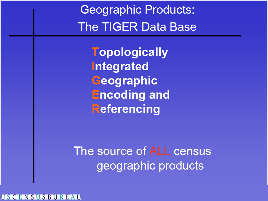
47 TIGER/Line Address Range Basics The complete chain has two address ranges: left: odd-numbered right: even-numbered. Potential address ranges along a complete chain have values that encompass the addresses of existing structures, as well as those not yet built
48 Coordinate Systems in TIGER/Line Files Global coordinate system: Lat/Long. No Projection some source maps scanned are in UTM projection, but then converted back to Lat/Long (causes error!) Position Accuracy: +/- 167 feet meet National Map Accuracy Standards. But not suitable for high-precision measurement applications, e.g. engineering, property transfer
Resolutions of Remote Sensing
 Resolutions of Remote Sensing 1. Spatial (what area and how detailed) 2. Spectral (what colors bands) 3. Temporal (time of day/season/year) 4. Radiometric (color depth) Spatial Resolution describes how
SAMPLE MIDTERM QUESTIONS
 Geography 309 Sample MidTerm Questions Page 1 SAMPLE MIDTERM QUESTIONS Textbook Questions Chapter 1 Questions 4, 5, 6, Chapter 2 Questions 4, 7, 10 Chapter 4 Questions 8, 9 Chapter 10 Questions 1, 4, 7
Review for Introduction to Remote Sensing: Science Concepts and Technology
 Review for Introduction to Remote Sensing: Science Concepts and Technology Ann Johnson Associate Director ann@baremt.com Funded by National Science Foundation Advanced Technological Education program [DUE
A remote sensing instrument collects information about an object or phenomenon within the
 Satellite Remote Sensing GE 4150- Natural Hazards Some slides taken from Ann Maclean: Introduction to Digital Image Processing Remote Sensing the art, science, and technology of obtaining reliable information
Mapping Earth from Space Remote sensing and satellite images. Remote sensing developments from war
 Mapping Earth from Space Remote sensing and satellite images Geomatics includes all the following spatial technologies: a. Cartography "The art, science and technology of making maps" b. Geographic Information
Spectral Response for DigitalGlobe Earth Imaging Instruments
 Spectral Response for DigitalGlobe Earth Imaging Instruments IKONOS The IKONOS satellite carries a high resolution panchromatic band covering most of the silicon response and four lower resolution spectral
Hyperspectral Satellite Imaging Planning a Mission
 Hyperspectral Satellite Imaging Planning a Mission Victor Gardner University of Maryland 2007 AIAA Region 1 Mid-Atlantic Student Conference National Institute of Aerospace, Langley, VA Outline Objective
Remote Sensing Satellite Information Sheets Geophysical Institute University of Alaska Fairbanks
 Remote Sensing Satellite Information Sheets Geophysical Institute University of Alaska Fairbanks ASTER Advanced Spaceborne Thermal Emission and Reflection Radiometer AVHRR Advanced Very High Resolution
Active and Passive Microwave Remote Sensing
 Active and Passive Microwave Remote Sensing Passive remote sensing system record EMR that was reflected (e.g., blue, green, red, and near IR) or emitted (e.g., thermal IR) from the surface of the Earth.
High Resolution Information from Seven Years of ASTER Data
 High Resolution Information from Seven Years of ASTER Data Anna Colvin Michigan Technological University Department of Geological and Mining Engineering and Sciences Outline Part I ASTER mission Terra
2.3 Spatial Resolution, Pixel Size, and Scale
 Section 2.3 Spatial Resolution, Pixel Size, and Scale Page 39 2.3 Spatial Resolution, Pixel Size, and Scale For some remote sensing instruments, the distance between the target being imaged and the platform,
Remote sensing is the collection of data without directly measuring the object it relies on the
 Chapter 8 Remote Sensing Chapter Overview Remote sensing is the collection of data without directly measuring the object it relies on the reflectance of natural or emitted electromagnetic radiation (EMR).
Preface. Ko Ko Lwin Division of Spatial Information Science University of Tsukuba 2008
 1 Preface Remote Sensing data is one of the primary data sources in GIS analysis. The objective of this material is to provide fundamentals of Remote Sensing technology and its applications in Geographical
Digital image processing
 746A27 Remote Sensing and GIS Lecture 4 Digital image processing Chandan Roy Guest Lecturer Department of Computer and Information Science Linköping University Digital Image Processing Most of the common
Digital Remote Sensing Data Processing Digital Remote Sensing Data Processing and Analysis: An Introduction and Analysis: An Introduction
 Digital Remote Sensing Data Processing Digital Remote Sensing Data Processing and Analysis: An Introduction and Analysis: An Introduction Content Remote sensing data Spatial, spectral, radiometric and
How Landsat Images are Made
 How Landsat Images are Made Presentation by: NASA s Landsat Education and Public Outreach team June 2006 1 More than just a pretty picture Landsat makes pretty weird looking maps, and it isn t always easy
WATER BODY EXTRACTION FROM MULTI SPECTRAL IMAGE BY SPECTRAL PATTERN ANALYSIS
 WATER BODY EXTRACTION FROM MULTI SPECTRAL IMAGE BY SPECTRAL PATTERN ANALYSIS Nguyen Dinh Duong Department of Environmental Information Study and Analysis, Institute of Geography, 18 Hoang Quoc Viet Rd.,
SPOT Satellite Earth Observation System Presentation to the JACIE Civil Commercial Imagery Evaluation Workshop March 2007
 SPOT Satellite Earth Observation System Presentation to the JACIE Civil Commercial Imagery Evaluation Workshop March 2007 Topics Presented Quick summary of system characteristics Formosat-2 Satellite Archive
Using Remote Sensing to Monitor Soil Carbon Sequestration
 Using Remote Sensing to Monitor Soil Carbon Sequestration E. Raymond Hunt, Jr. USDA-ARS Hydrology and Remote Sensing Beltsville Agricultural Research Center Beltsville, Maryland Introduction and Overview
Chapter Contents Page No
 Chapter Contents Page No Preface Acknowledgement 1 Basics of Remote Sensing 1 1.1. Introduction 1 1.2. Definition of Remote Sensing 1 1.3. Principles of Remote Sensing 1 1.4. Various Stages in Remote Sensing
SATELLITE IMAGES IN ENVIRONMENTAL DATA PROCESSING
 SATELLITE IMAGES IN ENVIRONMENTAL DATA PROCESSING Magdaléna Kolínová Aleš Procházka Martin Slavík Prague Institute of Chemical Technology Department of Computing and Control Engineering Technická 95, 66
Design of a High Resolution Multispectral Scanner for Developing Vegetation Indexes
 Design of a High Resolution Multispectral Scanner for Developing Vegetation Indexes Rishitosh kumar sinha*, Roushan kumar mishra, Sam jeba kumar, Gunasekar. S Dept. of Instrumentation & Control Engg. S.R.M
Data Processing Flow Chart
 Legend Start V1 V2 V3 Completed Version 2 Completion date Data Processing Flow Chart Data: Download a) AVHRR: 1981-1999 b) MODIS:2000-2010 c) SPOT : 1998-2002 No Progressing Started Did not start 03/12/12
Remote Sensing. Vandaag. Voordelen Remote Sensing Wat is Remote Sensing? Vier elementen Remote Sensing systeem
 Remote Sensing 1 Vandaag Voordelen Remote Sensing Wat is Remote Sensing? Vier elementen Remote Sensing systeem 2 Nederland Vanaf 700 km hoogte Landsat TM mozaïek 3 Europa vanaf 36000 km hoogte 4 5 Mount
Electromagnetic Radiation (EMR) and Remote Sensing
 and Remote Sensing") Electromagnetic Radiation (EMR) and Remote Sensing 1 Atmosphere Anything missing in between? Electromagnetic Radiation (EMR) is radiated by atomic particles at the source (the Sun), propagates through
Electromagnetic Radiation (EMR) and Remote Sensing 1 Atmosphere Anything missing in between? Electromagnetic Radiation (EMR) is radiated by atomic particles at the source (the Sun), propagates through
Information Contents of High Resolution Satellite Images
 Information Contents of High Resolution Satellite Images H. Topan, G. Büyüksalih Zonguldak Karelmas University K. Jacobsen University of Hannover, Germany Keywords: satellite images, mapping, resolution,
Clouds and the Energy Cycle
 August 1999 NF-207 The Earth Science Enterprise Series These articles discuss Earth's many dynamic processes and their interactions Clouds and the Energy Cycle he study of clouds, where they occur, and
16 th IOCCG Committee annual meeting. Plymouth, UK 15 17 February 2011. mission: Present status and near future
 16 th IOCCG Committee annual meeting Plymouth, UK 15 17 February 2011 The Meteor 3M Mt satellite mission: Present status and near future plans MISSION AIMS Satellites of the series METEOR M M are purposed
Remote Sensing an Introduction
 Remote Sensing an Introduction Seminar: Space is the Place Referenten: Anica Huck & Michael Schlund Remote Sensing means the observation of, or gathering information about, a target by a device separated
Geography 403 Lecture 7 Scanners, Thermal, and Microwave
 Geography 403 Lecture 7 Scanners, Thermal, and Microwave Needs: Lect_403_7.ppt A. Basics of Passive Electric Sensors 1. Sensors absorb EMR and produce some sort of response, such as voltages differences
CBERS Program Update Jacie 2011. Frederico dos Santos Liporace AMS Kepler liporace@amskepler.com
 CBERS Program Update Jacie 2011 Frederico dos Santos Liporace AMS Kepler liporace@amskepler.com Overview CBERS 3 and 4 characteristics Differences from previous CBERS satellites (CBERS 1/2/2B) Geometric
How To Make An Orthophoto
 ISSUE 2 SEPTEMBER 2014 TSA Endorsed by: CLIENT GUIDE TO DIGITAL ORTHO- PHOTOGRAPHY The Survey Association s Client Guides are primarily aimed at other professionals such as engineers, architects, planners
See Lab 8, Natural Resource Canada RS Tutorial web pages Tues 3/24 Supervised land cover classification See Lab 9, NR Canada RS Tutorial web pages
 SFR 406 Remote Sensing, Image Interpretation and Forest Mapping EXAM # 2 (23 April 2015) REVIEW SHEET www.umaine.edu/mial/courses/sfr406/index.htm (Lecture powerpoint & notes) TOPICS COVERED ON 2 nd EXAM:
SESSION 8: GEOGRAPHIC INFORMATION SYSTEMS AND MAP PROJECTIONS
 SESSION 8: GEOGRAPHIC INFORMATION SYSTEMS AND MAP PROJECTIONS KEY CONCEPTS: In this session we will look at: Geographic information systems and Map projections. Content that needs to be covered for examination
Using Remote Sensing Imagery to Evaluate Post-Wildfire Damage in Southern California
 Graham Emde GEOG 3230 Advanced Remote Sensing February 22, 2013 Lab #1 Using Remote Sensing Imagery to Evaluate Post-Wildfire Damage in Southern California Introduction Wildfires are a common disturbance
MULTIPURPOSE USE OF ORTHOPHOTO MAPS FORMING BASIS TO DIGITAL CADASTRE DATA AND THE VISION OF THE GENERAL DIRECTORATE OF LAND REGISTRY AND CADASTRE
 MULTIPURPOSE USE OF ORTHOPHOTO MAPS FORMING BASIS TO DIGITAL CADASTRE DATA AND THE VISION OF THE GENERAL DIRECTORATE OF LAND REGISTRY AND CADASTRE E.ÖZER, H.TUNA, F.Ç.ACAR, B.ERKEK, S.BAKICI General Directorate
Precipitation Remote Sensing
 Precipitation Remote Sensing Huade Guan Prepared for Remote Sensing class Earth & Environmental Science University of Texas at San Antonio November 14, 2005 Outline Background Remote sensing technique
APPLICATION OF TERRA/ASTER DATA ON AGRICULTURE LAND MAPPING. Genya SAITO*, Naoki ISHITSUKA*, Yoneharu MATANO**, and Masatane KATO***
 APPLICATION OF TERRA/ASTER DATA ON AGRICULTURE LAND MAPPING Genya SAITO*, Naoki ISHITSUKA*, Yoneharu MATANO**, and Masatane KATO*** *National Institute for Agro-Environmental Sciences 3-1-3 Kannondai Tsukuba
INVESTIGA I+D+i 2013/2014
 INVESTIGA I+D+i 2013/2014 SPECIFIC GUIDELINES ON AEROSPACE OBSERVATION OF EARTH Text by D. Eduardo de Miguel October, 2013 Introducction Earth observation is the use of remote sensing techniques to better
D.S. Boyd School of Earth Sciences and Geography, Kingston University, U.K.
 PHYSICAL BASIS OF REMOTE SENSING D.S. Boyd School of Earth Sciences and Geography, Kingston University, U.K. Keywords: Remote sensing, electromagnetic radiation, wavelengths, target, atmosphere, sensor,
The RapidEye optical satellite family for high resolution imagery
 'Photogrammetric Week 01' D. Fritsch & R. Spiller, Eds. Wichmann Verlag, Heidelberg 2001. Scherer, Krischke 139 The RapidEye optical satellite family for high resolution imagery STEFAN SCHERER and MANFRED
Selecting the appropriate band combination for an RGB image using Landsat imagery
 Selecting the appropriate band combination for an RGB image using Landsat imagery Ned Horning Version: 1.0 Creation Date: 2004-01-01 Revision Date: 2004-01-01 License: This document is licensed under a
Landsat Monitoring our Earth s Condition for over 40 years
 Landsat Monitoring our Earth s Condition for over 40 years Thomas Cecere Land Remote Sensing Program USGS ISPRS:Earth Observing Data and Tools for Health Studies Arlington, VA August 28, 2013 U.S. Department
COLLATED QUESTIONS: ELECTROMAGNETIC RADIATION
 COLLATED QUESTIONS: ELECTROMAGNETIC RADIATION 2011(2): WAVES Doppler radar can determine the speed and direction of a moving car. Pulses of extremely high frequency radio waves are sent out in a narrow
The USGS Landsat Big Data Challenge
 The USGS Landsat Big Data Challenge Brian Sauer Engineering and Development USGS EROS bsauer@usgs.gov U.S. Department of the Interior U.S. Geological Survey USGS EROS and Landsat 2 Data Utility and Exploitation
Understanding Raster Data
 Introduction The following document is intended to provide a basic understanding of raster data. Raster data layers (commonly referred to as grids) are the essential data layers used in all tools developed
RS platforms. Fabio Dell Acqua - Gruppo di Telerilevamento
 RS platforms Platform vs. instrument Sensor Platform Instrument The remote sensor can be ideally represented as an instrument carried by a platform Platforms Remote Sensing: Ground-based air-borne space-borne
The Role of SPOT Satellite Images in Mapping Air Pollution Caused by Cement Factories
 The Role of SPOT Satellite Images in Mapping Air Pollution Caused by Cement Factories Dr. Farrag Ali FARRAG Assistant Prof. at Civil Engineering Dept. Faculty of Engineering Assiut University Assiut, Egypt.
ENVIRONMENTAL MONITORING Vol. I - Remote Sensing (Satellite) System Technologies - Michael A. Okoye and Greg T. Koeln
 System Technologies - Michael A. Okoye and Greg T. Koeln") REMOTE SENSING (SATELLITE) SYSTEM TECHNOLOGIES Michael A. Okoye and Greg T. Earth Satellite Corporation, Rockville Maryland, USA Keywords: active microwave, advantages of satellite remote sensing, atmospheric
REMOTE SENSING (SATELLITE) SYSTEM TECHNOLOGIES Michael A. Okoye and Greg T. Earth Satellite Corporation, Rockville Maryland, USA Keywords: active microwave, advantages of satellite remote sensing, atmospheric
INTRODUCTION TO REMOTE SENSING
 INTRODUCTION TO REMOTE SENSING Dr Robert Sanderson New Mexico State University Satellite picture of Las Cruces, NM Table of Contents Introduction...1 Electromagnetic energy...1 Reflection and absorption...2
TerraColor White Paper
 TerraColor White Paper TerraColor is a simulated true color digital earth imagery product developed by Earthstar Geographics LLC. This product was built from imagery captured by the US Landsat 7 (ETM+)
Introduction to Remote Sensing and Image Processing
 Introduction to Remote Sensing and Image Processing Of all the various data sources used in GIS, one of the most important is undoubtedly that provided by remote sensing. Through the use of satellites,
MODIS IMAGES RESTORATION FOR VNIR BANDS ON FIRE SMOKE AFFECTED AREA
 MODIS IMAGES RESTORATION FOR VNIR BANDS ON FIRE SMOKE AFFECTED AREA Li-Yu Chang and Chi-Farn Chen Center for Space and Remote Sensing Research, National Central University, No. 300, Zhongda Rd., Zhongli
ESCI 107/109 The Atmosphere Lesson 2 Solar and Terrestrial Radiation
 ESCI 107/109 The Atmosphere Lesson 2 Solar and Terrestrial Radiation Reading: Meteorology Today, Chapters 2 and 3 EARTH-SUN GEOMETRY The Earth has an elliptical orbit around the sun The average Earth-Sun
High Resolution RF Analysis: The Benefits of Lidar Terrain & Clutter Datasets
 0 High Resolution RF Analysis: The Benefits of Lidar Terrain & Clutter Datasets January 15, 2014 Martin Rais 1 High Resolution Terrain & Clutter Datasets: Why Lidar? There are myriad methods, techniques
MAPPING DETAILED DISTRIBUTION OF TREE CANOPIES BY HIGH-RESOLUTION SATELLITE IMAGES INTRODUCTION
 MAPPING DETAILED DISTRIBUTION OF TREE CANOPIES BY HIGH-RESOLUTION SATELLITE IMAGES Hideki Hashiba, Assistant Professor Nihon Univ., College of Sci. and Tech., Department of Civil. Engrg. Chiyoda-ku Tokyo
RESOLUTION MERGE OF 1:35.000 SCALE AERIAL PHOTOGRAPHS WITH LANDSAT 7 ETM IMAGERY
 RESOLUTION MERGE OF 1:35.000 SCALE AERIAL PHOTOGRAPHS WITH LANDSAT 7 ETM IMAGERY M. Erdogan, H.H. Maras, A. Yilmaz, Ö.T. Özerbil General Command of Mapping 06100 Dikimevi, Ankara, TURKEY - (mustafa.erdogan;
Take away concepts. What is Energy? Solar Energy. EM Radiation. Properties of waves. Solar Radiation Emission and Absorption
 Take away concepts Solar Radiation Emission and Absorption 1. 2. 3. 4. 5. 6. Conservation of energy. Black body radiation principle Emission wavelength and temperature (Wein s Law). Radiation vs. distance
Overview. What is EMR? Electromagnetic Radiation (EMR) LA502 Special Studies Remote Sensing
 LA502 Special Studies Remote Sensing") LA502 Special Studies Remote Sensing Electromagnetic Radiation (EMR) Dr. Ragab Khalil Department of Landscape Architecture Faculty of Environmental Design King AbdulAziz University Room 103 Overview What
LA502 Special Studies Remote Sensing Electromagnetic Radiation (EMR) Dr. Ragab Khalil Department of Landscape Architecture Faculty of Environmental Design King AbdulAziz University Room 103 Overview What
REMOTE SENSING AND ENVIRONMENTAL MONITORING. P. M. Mather School of Geography, The University of Nottingham, U.K.
 REMOTE SENSING AND ENVIRONMENTAL MONITORING P. M. Mather School of Geography, The University of Nottingham, U.K. Keywords: Earth observation, image processing, lidar, pattern recognition, radar Contents
Overview of the IR channels and their applications
 Ján Kaňák Slovak Hydrometeorological Institute Jan.kanak@shmu.sk Overview of the IR channels and their applications EUMeTrain, 14 June 2011 Ján Kaňák, SHMÚ 1 Basics in satellite Infrared image interpretation
Estimating Firn Emissivity, from 1994 to1998, at the Ski Hi Automatic Weather Station on the West Antarctic Ice Sheet Using Passive Microwave Data
 Estimating Firn Emissivity, from 1994 to1998, at the Ski Hi Automatic Weather Station on the West Antarctic Ice Sheet Using Passive Microwave Data Mentor: Dr. Malcolm LeCompte Elizabeth City State University
A KNOWLEDGE-BASED APPROACH FOR REDUCING CLOUD AND SHADOW ABSTRACT
 A KNOWLEDGE-BASED APPROACH FOR REDUCING CLOUD AND SHADOW Mingjun Song, Graduate Research Assistant Daniel L. Civco, Director Laboratory for Earth Resources Information Systems Department of Natural Resources
Imagery. 1:50,000 Basemap Generation From Satellite. 1 Introduction. 2 Input Data
 1:50,000 Basemap Generation From Satellite Imagery Lisbeth Heuse, Product Engineer, Image Applications Dave Hawkins, Product Manager, Image Applications MacDonald Dettwiler, 3751 Shell Road, Richmond B.C.
'Developments and benefits of hydrographic surveying using multispectral imagery in the coastal zone
 Abstract With the recent launch of enhanced high-resolution commercial satellites, available imagery has improved from four-bands to eight-band multispectral. Simultaneously developments in remote sensing
Some elements of photo. interpretation
 Some elements of photo Shape Size Pattern Color (tone, hue) Texture Shadows Site Association interpretation Olson, C. E., Jr. 1960. Elements of photographic interpretation common to several sensors. Photogrammetric
Land Use/Land Cover Map of the Central Facility of ARM in the Southern Great Plains Site Using DOE s Multi-Spectral Thermal Imager Satellite Images
 Land Use/Land Cover Map of the Central Facility of ARM in the Southern Great Plains Site Using DOE s Multi-Spectral Thermal Imager Satellite Images S. E. Báez Cazull Pre-Service Teacher Program University
ENVI THE PREMIER SOFTWARE FOR EXTRACTING INFORMATION FROM GEOSPATIAL IMAGERY.
 ENVI THE PREMIER SOFTWARE FOR EXTRACTING INFORMATION FROM GEOSPATIAL IMAGERY. ENVI Imagery Becomes Knowledge ENVI software uses proven scientific methods and automated processes to help you turn geospatial
ANALYSIS OF FOREST CHANGE IN FIRE DAMAGE AREA USING SATELLITE IMAGES
 ANALYSIS OF FOREST CHANGE IN FIRE DAMAGE AREA USING SATELLITE IMAGES Joon Mook Kang, Professor Joon Kyu Park, Ph.D Min Gyu Kim, Ph.D._Candidate Dept of Civil Engineering, Chungnam National University 220
From lowest energy to highest energy, which of the following correctly orders the different categories of electromagnetic radiation?
 From lowest energy to highest energy, which of the following correctly orders the different categories of electromagnetic radiation? From lowest energy to highest energy, which of the following correctly
CHAPTER 2 Energy and Earth
 CHAPTER 2 Energy and Earth This chapter is concerned with the nature of energy and how it interacts with Earth. At this stage we are looking at energy in an abstract form though relate it to how it affect
Authors: Thierry Phulpin, CNES Lydie Lavanant, Meteo France Claude Camy-Peyret, LPMAA/CNRS. Date: 15 June 2005
 Comments on the number of cloud free observations per day and location- LEO constellation vs. GEO - Annex in the final Technical Note on geostationary mission concepts Authors: Thierry Phulpin, CNES Lydie
Generation of Cloud-free Imagery Using Landsat-8
 Generation of Cloud-free Imagery Using Landsat-8 Byeonghee Kim 1, Youkyung Han 2, Yonghyun Kim 3, Yongil Kim 4 Department of Civil and Environmental Engineering, Seoul National University (SNU), Seoul,
Obtaining and Processing MODIS Data
 Obtaining and Processing MODIS Data MODIS is an extensive program using sensors on two satellites that each provide complete daily coverage of the earth. The data have a variety of resolutions; spectral,
Astronomy 110 Homework #04 Assigned: 02/06/2007 Due: 02/13/2007. Name:
 Astronomy 110 Homework #04 Assigned: 02/06/2007 Due: 02/13/2007 Name: Directions: Listed below are twenty (20) multiple-choice questions based on the material covered by the lectures this past week. Choose
STAAR Science Tutorial 30 TEK 8.8C: Electromagnetic Waves
 Name: Teacher: Pd. Date: STAAR Science Tutorial 30 TEK 8.8C: Electromagnetic Waves TEK 8.8C: Explore how different wavelengths of the electromagnetic spectrum such as light and radio waves are used to
Big data and Earth observation New challenges in remote sensing images interpretation
 Big data and Earth observation New challenges in remote sensing images interpretation Pierre Gançarski ICube CNRS - Université de Strasbourg 2014 Pierre Gançarski Big data and Earth observation 1/58 1
Myths and misconceptions about remote sensing
 Myths and misconceptions about remote sensing Ned Horning (graphics support - Nicholas DuBroff) Version: 1.0 Creation Date: 2004-01-01 Revision Date: 2004-01-01 License: This document is licensed under
Examination Space Missions and Applications I (AE2103) Faculty of Aerospace Engineering Delft University of Technology SAMPLE EXAM
 Faculty of Aerospace Engineering Delft University of Technology SAMPLE EXAM") Examination Space Missions and Applications I AE2103 Faculty of Aerospace Engineering Delft University of Technology SAMPLE EXAM Please read these instructions first: This are a series of multiple-choice
Examination Space Missions and Applications I AE2103 Faculty of Aerospace Engineering Delft University of Technology SAMPLE EXAM Please read these instructions first: This are a series of multiple-choice
The premier software for extracting information from geospatial imagery.
 Imagery Becomes Knowledge ENVI The premier software for extracting information from geospatial imagery. ENVI Imagery Becomes Knowledge Geospatial imagery is used more and more across industries because
GIS and Remote Sensing in Diachronic Study of Agriculture in Greece
 GIS and Remote Sensing in Diachronic Study of Agriculture in Greece Maria Androulidaki a, Michail Salampasis b, Vagis Samathrakis c, Christos Batzios d a Alexander Technology Educational Institute of Thessaloniki,
ENVI Classic Tutorial: Atmospherically Correcting Multispectral Data Using FLAASH 2
 ENVI Classic Tutorial: Atmospherically Correcting Multispectral Data Using FLAASH Atmospherically Correcting Multispectral Data Using FLAASH 2 Files Used in this Tutorial 2 Opening the Raw Landsat Image
Studying cloud properties from space using sounder data: A preparatory study for INSAT-3D
 Studying cloud properties from space using sounder data: A preparatory study for INSAT-3D Munn V. Shukla and P. K. Thapliyal Atmospheric Sciences Division Atmospheric and Oceanic Sciences Group Space Applications
What s better than a milliondollar
 F o r k i d s o f a l l a g e s BY MEMORIE YASUDA What s better than a milliondollar view from the top of a skyscraper? Try a multimillion-dollar view from a satellite flying around Earth. A satellite
LANDSAT 7 - GROUND SEGMENT ACTIVITIES AT THE GERMAN REMOTE SENSING DATA CENTER. Deutsches Fernerkundungsdatenzentrum (DFD) DLR (*)
 DLR (*)") LANDSAT 7 - GROUND SEGMENT ACTIVITIES AT THE GERMAN REMOTE SENSING DATA CENTER Günter Strunz (*), Hans-Dietrich Bettac (**), Jörg Gredel (*), Klaus-Dieter Reiniger (*) & Gunter Schreier (*) Deutsches Fernerkundungsdatenzentrum
LANDSAT 7 - GROUND SEGMENT ACTIVITIES AT THE GERMAN REMOTE SENSING DATA CENTER Günter Strunz (*), Hans-Dietrich Bettac (**), Jörg Gredel (*), Klaus-Dieter Reiniger (*) & Gunter Schreier (*) Deutsches Fernerkundungsdatenzentrum
Evaluation of the Effect of Upper-Level Cirrus Clouds on Satellite Retrievals of Low-Level Cloud Droplet Effective Radius
 Evaluation of the Effect of Upper-Level Cirrus Clouds on Satellite Retrievals of Low-Level Cloud Droplet Effective Radius F.-L. Chang and Z. Li Earth System Science Interdisciplinary Center University
Remote Sensing in Natural Resources Mapping
 Remote Sensing in Natural Resources Mapping NRS 516, Spring 2016 Overview of Remote Sensing in Natural Resources Mapping What is remote sensing? Why remote sensing? Examples of remote sensing in natural
Advanced Image Management using the Mosaic Dataset
 Esri International User Conference San Diego, California Technical Workshops July 25, 2012 Advanced Image Management using the Mosaic Dataset Vinay Viswambharan, Mike Muller Agenda ArcGIS Image Management
Temporal variation in snow cover over sea ice in Antarctica using AMSR-E data product
 Temporal variation in snow cover over sea ice in Antarctica using AMSR-E data product Michael J. Lewis Ph.D. Student, Department of Earth and Environmental Science University of Texas at San Antonio ABSTRACT
LANDSAT 8 Level 1 Product Performance
 Réf: IDEAS-TN-10-QualityReport LANDSAT 8 Level 1 Product Performance Quality Report Month/Year: January 2016 Date: 26/01/2016 Issue/Rev:1/9 1. Scope of this document On May 30, 2013, data from the Landsat
Recent advances in Satellite Imagery for Oil and Gas Exploration and Production. DESK AND DERRICK APRIL 2016 PRESENTED BY GARY CREWS---RETIRED
 Recent advances in Satellite Imagery for Oil and Gas Exploration and Production. DESK AND DERRICK APRIL 2016 PRESENTED BY GARY CREWS---RETIRED Agenda Brief review of state of the applications in 2010 Basics
Two primary advantages of radars: all-weather and day /night imaging
 Lecture 0 Principles of active remote sensing: Radars. Objectives: 1. Radar basics. Main types of radars.. Basic antenna parameters. Required reading: G: 8.1, p.401-40 dditional/advanced reading: Online
Analysis of Landsat ETM+ Image Enhancement for Lithological Classification Improvement in Eagle Plain Area, Northern Yukon
 Analysis of Landsat ETM+ Image Enhancement for Lithological Classification Improvement in Eagle Plain Area, Northern Yukon Shihua Zhao, Department of Geology, University of Calgary, zhaosh@ucalgary.ca,
Treasure Hunt. Lecture 2 How does Light Interact with the Environment? EMR Principles and Properties. EMR and Remote Sensing
 Lecture 2 How does Light Interact with the Environment? Treasure Hunt Find and scan all 11 QR codes Choose one to watch / read in detail Post the key points as a reaction to http://www.scoop.it/t/env202-502-w2
NATIONAL OPEN UNIVERSITY OF NIGERIA SCHOOL OF SCIENCE AND TECHNOLOGY COURSE CODE: ESM 392
 NATIONAL OPEN UNIVERSITY OF NIGERIA SCHOOL OF SCIENCE AND TECHNOLOGY COURSE CODE: ESM 392 COURSE TITLE: REMOTE SENSING AND RADIATION PRINCIPLES MODULE 1 [INTRODUCTION TO REMOTE SENSING AND RADIATION PRINCIPLES]
THE SPECTRAL DIMENSION IN URBAN LAND COVER MAPPING FROM HIGH - RESOLUTION OPTICAL REMOTE SENSING DATA *
 THE SPECTRAL DIMENSION IN URBAN LAND COVER MAPPING FROM HIGH - RESOLUTION OPTICAL REMOTE SENSING DATA * Martin Herold 1, Meg Gardner 1, Brian Hadley 2 and Dar Roberts 1 1 Department of Geography, University
Optical multi-spectral images: processing and applications
 Earth Observation Laboratory PhD Program in GeoInformation DISP - Tor Vergata University Optical multi-spectral images: processing and applications Riccardo Duca The last time What means Optical Remote
ATM S 111, Global Warming: Understanding the Forecast
 ATM S 111, Global Warming: Understanding the Forecast DARGAN M. W. FRIERSON DEPARTMENT OF ATMOSPHERIC SCIENCES DAY 1: OCTOBER 1, 2015 Outline How exactly the Sun heats the Earth How strong? Important concept
Soil degradation monitoring by active and passive remote-sensing means: examples with two degradation processes
 Soil degradation monitoring by active and passive remote-sensing means: examples with two degradation processes Naftaly Goldshleger, *Eyal Ben-Dor,* *Ido Livne,* U. Basson***, and R.Ben-Binyamin*Vladimir
Introduction. Stefano Ferrari. Università degli Studi di Milano stefano.ferrari@unimi.it. Elaborazione delle immagini (Image processing I)
") Introduction Stefano Ferrari Università degli Studi di Milano stefano.ferrari@unimi.it Elaborazione delle immagini (Image processing I) academic year 2011 2012 Image processing Computer science concerns
Introduction Stefano Ferrari Università degli Studi di Milano stefano.ferrari@unimi.it Elaborazione delle immagini (Image processing I) academic year 2011 2012 Image processing Computer science concerns