How To Develop An International Framework For Analysis Of Fluvial Morphological Processes
|
|
|
- Charla McCoy
- 3 years ago
- Views:
Transcription
1 ADVANCES IN RIVER SCIENCE CONFERENCE Swansea, April 2011 A new methodological framework for stream hydromorphological assessment, analysis and monitoring (IDRAIM) Massimo Rinaldi 1, Nicola Surian 2, Francesco Comiti 3, Martina Bussettini 4 1 Dipartimento di Ingegneria Civile e Ambientale, Università di Firenze 2 Dipartimento di Geografia, Università di Padova 3 Facoltà di Scienze e Tecnologie, Libera Università di Bozen-Bolzano 4 Istituto Superiore per la Protezione e la Ricerca Ambientale (ISPRA), Roma


2 EC Water Framework Directive: hydromorphology as one component of stream quality conditions Context EC Flood Directive: identification of measures to mitigate floods and related hazards Potentially conflicting objectives: - Quality - Safety

3 IDRAIM framework (sistema IDRomorfologico di valutazione, AnalisI e Monitoraggio dei corsi d acqua) Aim: to develop an overall methodological framework for analysis of fluvial morphological processes, integrating objectives of quality and safety, according to WFD and Flood Directive Project funded and developed in collaboration with: ISPRA, Istituto Superiore per la Protezione e la Ricerca Ambientale (Italian Environmental Agency)

 Existing methods River Styles Framework (Australia), Fluvial Audit (UK), SYRAH (France) Specific characteristics - Integration of morphological quality and")
4 IDRAIM framework Characteristics - Emphasis on geomorphic processes, sediment connectivity, trajectories of changes - Application to identification of possible strategies / actions for river management (target: public agencies) Existing methods River Styles Framework (Australia), Fluvial Audit (UK), SYRAH (France) Specific characteristics - Integration of morphological quality and fluvial dynamic hazard - Italian (european) context

5 Stage 1: General setting and initial segmentation Stage 2: Present morphological conditions and past channel evolution 2.1 Analysis of present and past conditions (A) Sediment sources; (B) Sediment connectivity; (C) Stream power; (D) Transport capacity; (E) Trajectories of changes; (F) Causes of channel evolution 2.2 Evaluation and analysis of morphological quality Morphological Quality Index 2.3 Evaluation and analysis of morphological dynamics hazard Morphological dynamics hazard index 2.4 Synthesis of problems Stage 3: Future trends 3.1 Analysis of future scenarios (A) Possible trajectories of future evolution (B) Implications on morphological quality (C) Implications on hazard 3.2 Monitoring and post-monitoring evaluation Stage 4: Integrated management 4.1 Priorities 4.2 Conflicts and integration of objectives 4.3 Classification, analysis and management of HMWB 4.4 Monitoring post - interventions
 Possible trajectories of future evolution (B) Implications on morphological quality (C) Implications on hazard 3.")
6 IQM (Morphological Quality Index) Recently approved as hydromorphological assessment method by Italian Legislation on WFD implementation Main characteristics and novelties 1. It is not a Physical Habitat Assessment method 2. Designed for WFD but not exclusive 3. Designed for geomorphologists 4. It evaluates the morphological quality (independently from ecological implications) Approaches and methods (1) Remote sensing and GIS analysis (2) Field survey

7 IQM (Morphological Quality Index) Terrace Clay outcropping Incision


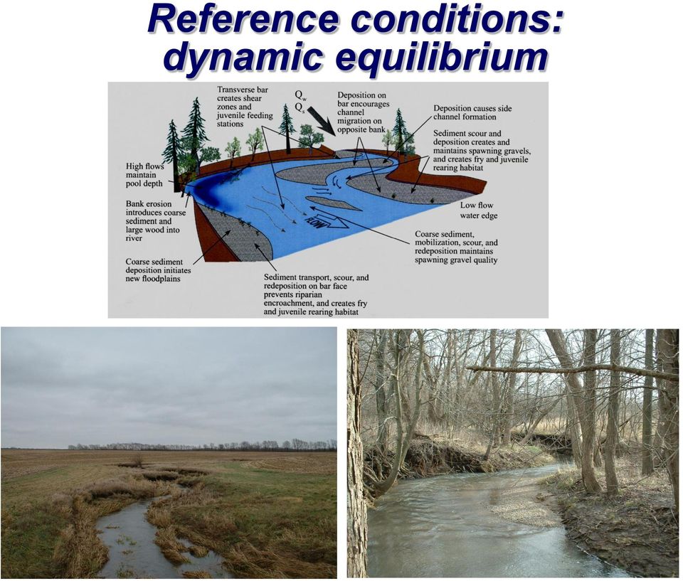
8 Reference conditions: dynamic equilibrium
9 Phase 1: Segmentation (1) Physiographic units; (2) Confinement; (3) Channel morphology; (4) Other discontinuities Reach: scale of application of IQM (1 5 km)

10 Phase 2: Morphological assessment 1. Continuity A. Longitudinal B. Lateral A. Channel pattern Functionality 2. Morphology B. Cross-section C. Substrate Artificiality Channel changes 3. Vegetation

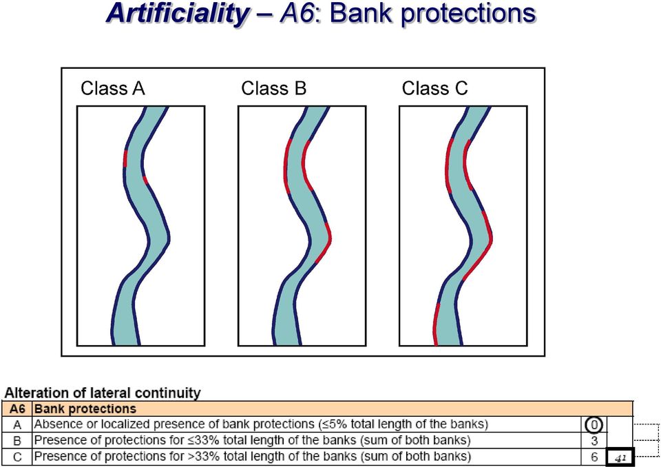
11 IQM indicators Functionality Continuity F1 Longitudinal continuity in sediment and wood flux F2 Presence of modern floodplain F3 Hillslopes stream connection F4 Processes of bank retreat F5 Presence of a potentially erodible corridor Morphology Channel pattern F6 Bed configuration valley slope F7 Forms and processes typical of the channel pattern F8 Presence of typical fluvial forms in the alluvial plain Cross-section configuration F9 Variability of the cross-section Bed substrate F10 Structure of the channel bed F11 Presence of in-channel large wood Vegetation F12 Width of functional formations in the fluvial corridor F13 Linear extension of functional vegetation Artificiality Upstream alteration of longitudinal continuity A1 Upstream alteration of channel-forming discharges A2 Upstream interception of sediment transport Alteration of longitudinal continuity in the reach A3 Alteration of channel-forming discharge in the reach A4 Interception of sediment transport in the reach A5 Crossing structures Alteration of lateral continuity A6 Bank protections A7 Artificial levees Alteration of channel morphology and/or substrate A8 Artificial changes of river course A9 Other structures of alteration of channel profile and/or substrate Interventions of removal A10 Sediment removal A11 Wood removal A12 Vegetation cutting V1 V2 V3 Channel changes Changes in channel pattern Changes in channel width Bed-level changes


12 Functionality F1: Longitudinal continuity in sediment and wood flux Class A Class B Class C

13 Artificiality A6: Bank protections

14 Channel changes - V1: Changes in channel pattern Class A Class C 1954 Class B

15 1. Very good (IQM = ) 2. Good (IQM = ) IQM=0.87 IQM= Moderate (IQM = ) 4. Poor (IQM = ) 5. Very poor (IQM = 0 0.3) IQM=0.60 IQM=0.43 Morphological Quality Index: IQM=1-IAM Morphological Alteration Index: IAM= Stot / Smax Total deviation: Stot = F1+ +F14+A1+ +A14+V1+ V3 IQM=0.04

16 IQM applications Unconfined Semiconfined Confined VERY GOOD GOOD MODERATE POOR VERY POOR Confined Braided wandering unconfined VERY GOOD GOOD MODERATE POOR VERY POOR VERY GOOD GOOD MODERATE POOR VERY POOR Single-thread unconfined


17 IQM applications 1,00 0,90 0,80 0,70 0,60 0,50 0,40 0,30 0,20 0,10 0,00 IQM V IQM A IQM F

18 Available material Guidebook for the evaluation of stream morphological conditions by the Morphological Quality Index (IQM) Illustrated Guide to the Answers Evaluation forms GB/Publications/Handbooks_and_Guidelines/Do cuments/manuale_66_2011.html

Deliverable 2.1: Multi-scale framework and indicators of hydromorphological processes and forms
 4 DELINEATION OF SPATIAL UNITS. 4.1 Regional Context: At this scale, no delineation is strictly necessary, since most catchments will fall within a single biogeographic region (various regionalisations
WATER RESOURCES ENGINEERING DESIGN LANDSCAPE ECOLOGY AND RIVER RESTORATION. www.sindlar.eu
 Geomorphological processes of watercourse development, system of typology and application of the results in practice Part 01 Analysis of geomorphological processes in watercourses Part 02 Applications
EFFECTS OF ARUNDO DONAX ON RIVER HYDRAULICS, SEDIMENT TRANSPORT, AND GEOMORPHOLOGY, SANTA MARGARITA RIVER, CALIFORNIA
 EFFECTS OF ARUNDO DONAX ON RIVER HYDRAULICS, SEDIMENT TRANSPORT, AND GEOMORPHOLOGY, SANTA MARGARITA RIVER, CALIFORNIA René Leclerc Geomorphologist Robert C. MacArthur, Ph.D., P.E. Principal Headwaters
Sediment Supply and the Upland-Stream Connection. Brian Bledsoe Department of Civil and Environmental Engineering Colorado State University
 Sediment Supply and the Upland-Stream Connection Brian Bledsoe Department of Civil and Environmental Engineering Colorado State University Overview The sediment system (with an eye towards hillslope processes
Bruce Orr and Zooey Diggory S T I L L W A T E R S C I E N C E S. Tom Dudley U C S A N T A B A R B A R A
 A case study from the lower Santa Clara River, CA: Strategic planning for control of Arundo donax and restoration of riparian vegetation in semi-arid landscapes Bruce Orr and Zooey Diggory S T I L L W
Basic Principles of Channel Design
 United States Department of Agriculture Natural Resources Conservation Service Stream Restoration Design Chapter 7 Basic Principles of Channel Design Issued August 2007 Cover photo: Where modification
Floodplain Connectivity in Restoration Design
 Floodplain Connectivity in Restoration Design 2015 Symposium on Restoration in a Contaminated Environment: Lessons Learned and Challenges in Moving Forward Part II April 2015 Karin Boyd Applied Geomorphology,
Flood Hazard Area Technical Manual Section 8 Bank Stabilization and Stream Restoration
 Flood Hazard Area Technical Manual Section 8 Bank Stabilization and Stream Restoration Prepared by: New Jersey Section American Water Resources Association Stream Restoration Committee FHA Subcommittee
National policy for the flood risk management plans (FD implementation)
") National policy for the flood risk management plans (FD implementation) Giuseppina Monacelli, Barbara Lastoria ISPRA Italian National Institute for Environmental Protection and Research ISPRA: Italian
National policy for the flood risk management plans (FD implementation) Giuseppina Monacelli, Barbara Lastoria ISPRA Italian National Institute for Environmental Protection and Research ISPRA: Italian
1 Introduction. 1.1 Key objective. 1.2 Why the South Esk
 1 Introduction 1.1 Key objective The aim of this study is to identify and assess possible options for improving the quality of the river channel and habitats in the River South Esk catchment whilst helping
SedAlp final conference. Bolzano, June 9 th 2015
 SedAlp final conference Bolzano, June 9 th 2015 SedAlp Sediment management in Alpine basins: integrating sediment continuum, risk mitigation and hydropower Introducing the background and project SedAlp
Stream Rehabilitation Concepts, Guidelines and Examples. Objectives. Pierre Y. Julien. Three Laws of Stream Restoration
 Stream Rehabilitation Concepts, Guidelines and Examples Pierre Y. Julien Wuhan 2005 Objectives Part I - Stream restoration and rehabilitation: 1. Present and discuss important concepts, laws, criteria
Guideline: Works that interfere with water in a watercourse watercourse diversions. September 2014
 Guideline: Works that interfere with water in a watercourse watercourse diversions September 2014 This publication has been compiled by the Department of Natural Resources and Mines. State of Queensland,
Neversink River East Branch
 Neversink River East Branch Management Unit 10 Summary of Post-Flood Recommendations Intervention Level Full restoration of the stream reach including the eroding bank site between Station 38380 and Station
GLOSSARY OF TERMS CHAPTER 11 WORD DEFINITION SOURCE. Leopold
 CHAPTER 11 GLOSSARY OF TERMS Active Channel The channel that contains the discharge Leopold where channel maintenance is most effective, sediment are actively transported and deposited, and that are capable
SedAlp kick-off meeting Vienna, March 12 th 2013
 SedAlp kick-off meeting Vienna, March 12 th 2013 SedAlp Sediment management in Alpine basins: integrating sediment continuum, risk mitigation and hydropower Introducing the background and project SedAlp
Progress of SIGC -Coastal Geographical Information System
 Progress of SIGC -Coastal Geographical Information System Filippo D Ascola, Angela Barbano ISPRA -Istituto Superiore per la Protezione e la Ricerca Ambientale Dip.to Tutela Acque Interne e Marine - Servizio
An Irish Strategy for River Restoration: How it works on the ground. Karen Delanty
 An Irish Strategy for River Restoration: How it works on the ground Karen Delanty River Restoration and EU Directives River Restoration in Ireland to-date; TAM (Tourism Angling Measure) Local small scale
Earth Science. River Systems and Landforms GEOGRAPHY 1710. The Hydrologic Cycle. Introduction. Running Water. Chapter 14.
 Earth Science GEOGRAPHY 1710 River Systems and Landforms DAVID R. SALLEE Robert W. Christopherson Charlie Thomsen Chapter 14 Introduction Rivers and streams are dynamic systems that continually adjust
Catchment Scale Processes and River Restoration. Dr Jenny Mant Jenny@therrc.co.uk. The River Restoration Centre therrc.co.uk
 Catchment Scale Processes and River Restoration Dr Jenny Mant Jenny@therrc.co.uk The River Restoration Centre therrc.co.uk 3 Main Catchment Elements Hydrology Energy associated with the flow of water affects
Interim Technical Guidelines for the Development of Environmental Management Plans for Underground Infrastructure Revised - July 2013.
 Interim Technical Guidelines for the Development of Environmental Management Plans for Underground Infrastructure Revised - July 2013 Rationale Underground infrastructure may be at risk from valley, streambank
IUCN Guidelines to Avoid Impacts of Water Resources Projects on Dams and Other Water Infrastructure
 IUCN Guidelines to Avoid Impacts of Water Resources Projects on Dams and Other Water Infrastructure (December 2013) IUCN does not engage in projects which involve the design, construction or rehabilitation
1.7.0 Floodplain Modification Criteria
 1.7.0 Floodplain Modification Criteria 1.7.1 Introduction These guidelines set out standards for evaluating and processing proposed modifications of the 100- year floodplain with the following objectives:
River floodplains in Germany in times of climate change
 River floodplains in Germany in times of climate change Bernd Neukirchen Head of Division II 3.2 Inland Waters, Floodplain Ecosystems, Water Balance Foto: Olaf Büttner/UFZ Climate change and floodplains
Concepts for Post Flood River Corridor Restoration
 Concepts for Post-Flood River Corridor Restoration Dave Rosgen, P.H., Ph.D. Wildland Hydrology Fort Collins, Colorado A Special Thanks to our Sponsors: Copyright 2014 Wildland Hydrology 1 Workshop Goals
General Permit for Activities Promoting Waterway - Floodplain Connectivity [working title]
![General Permit for Activities Promoting Waterway - Floodplain Connectivity [working title]](/thumbs/39/18645965.jpg "General Permit for Activities Promoting Waterway - Floodplain Connectivity [working title]") General Permit for Activities Promoting Waterway - Floodplain Connectivity [working title] Purpose These rules set forth the conditions under which a person may, without an individual removal-fill permit
General Permit for Activities Promoting Waterway - Floodplain Connectivity [working title] Purpose These rules set forth the conditions under which a person may, without an individual removal-fill permit
DRAFT SOUTH FORK SKYKOMISH RIVER
 DRAFT SOUTH FORK SKYKOMISH RIVER 9 levees and revetments / Approximately 1.1 miles of river bank are armored Revetments provide limited, localized erosion protection, but impact habitat Frequent and costly
Course Plan Day 1: Introduction and Overview Hydrology & Fluvial Geomorphology Day 2: Fieldwork on the Braid Burn Alan Jones
 Course Plan Day 1: Introduction and Overview Hydrology & Fluvial Geomorphology Alan Jones E:mail: Alan.Jones@ed.ac.uk Water cycle Globally & Locally River shapes and forms River behaviour Closer look at
Restoration Planning and Development of a Restoration Bank
 Restoration Planning and Development of a Restoration Bank Black Creek Pioneer Village, South Theatre 8:30 a.m. to 3:30 p.m. Habitat Restoration and Environmental Monitoring Projects Section Restoration
ArcGIS Model Build. ArcGIS Geodatabase. Brian Beckett (Inland Fisheries Ireland) and Dr. Sally Cook (Supervisor, University of Ulster, Coleraine)
 and Dr. Sally Cook (Supervisor, University of Ulster, Coleraine)") An evaluation of GIS for the predictive modelling and mapping of specific stream power, substratum particle size and potential juvenile lamprey habitat Brian Beckett (Inland Fisheries Ireland) and Dr.
An evaluation of GIS for the predictive modelling and mapping of specific stream power, substratum particle size and potential juvenile lamprey habitat Brian Beckett (Inland Fisheries Ireland) and Dr.
Evaluation of Open Channel Flow Equations. Introduction :
 Evaluation of Open Channel Flow Equations Introduction : Most common hydraulic equations for open channels relate the section averaged mean velocity (V) to hydraulic radius (R) and hydraulic gradient (S).
The Active River Area
 April 2008 The Active River Area ACKNOWLEDGEMENTS The authors wish to thank the following people whose thoughtful reviews, comments and other support helped to shape and inform this document. Special thanks
Ruby River Grayling - Gravel Spawning Beds Monitoring Report January 2008
 Ruby River Grayling - Gravel Spawning Beds Monitoring Report January 2008 In partnership with Montana Department of Fish, Wildlife, and Parks (FWP), American Wildlands, and Wildlife Forever, the Madison
City of Austin Stream Restoration Program Mid-Atlantic Stream Restoration Conference, Rocky Gap, MD November 2011
 Welcome City of Austin Stream Restoration Program Mid-Atlantic Stream Restoration Conference, Rocky Gap, MD November 2011 Morgan Byars, P.E. City of Austin Watershed Protection Department Environmental
Flood Zone Investigation by using Satellite and Aerial Imagery
 Flood Zone Investigation by using Satellite and Aerial Imagery Younes Daneshbod Islamic Azad University-Arsanjan branch Daneshgah Boulevard, Islamid Azad University, Arsnjan, Iran Email: daneshbod@gmail.com
A Stream Restoration Case Study in the California Central Coast
 International Erosion Control Association Annual Conference 2009, Reno, Nevada Case Study Technical Presentation A Stream Restoration Case Study in the California Central Coast Justin S. Rogers, P.E.,
EXPERIMENTAL INVESTIGATION OF FLOODING PROBLEM- A CASE STUDY ON ARUNAVATI RIVER IN SHIRPUR CITY BY TOTAL STATION SURVEY
 International Journal of Civil Engineering and Technology (IJCIET) Volume 7, Issue 1, Jan-Feb 2016, pp. 172-179, Article ID: IJCIET_07_01_014 Available online at http://www.iaeme.com/ijciet/issues.asp?jtype=ijciet&vtype=7&itype=1
Assessing Rivers for Restoration Purposes. Ann L. Riley Waterways Restoration Institute
 Assessing Rivers for Restoration Purposes Ann L. Riley Waterways Restoration Institute Assessing Rivers for Restoration Purposes Ann L. Riley Waterways Restoration Institute Assessing Rivers for Restoration
Thank you to all of our 2015 sponsors: Media Partner
 Thank you to all of our 2015 sponsors: Media Partner Channel Naturalization: Planning and Implementation in Peel Region TRIECA March 25 & 26, 2015 Peel Region Channel Remediation Strategy An Urban Context
7.0 Stream Restoration
 7.0 Stream Restoration 7.1 Issue Statements One of the primary concerns of residents in the Bassett Creek watershed is the maintenance of the natural beauty of the creek in residential and recreational
Appendix C. Project Opportunities. Middle Twisp River (RM 7.8 18.12)
") Appendix C Project Opportunities Middle Twisp River (RM 7.8 18.12) This table describes project opportunities by project area. Locator maps of the project opportunities are included below the table. Reach
Appendix C Project Opportunities Middle Twisp River (RM 7.8 18.12) This table describes project opportunities by project area. Locator maps of the project opportunities are included below the table. Reach
C1 T S BLENCH HYDRAULICS LABORATORY, UNIVERSITY OF ALBERTA, EDMONTON
 Land and Water Australia Project JCU 15 Travelling Fellowship 2001, 2002 Ross Kapitzke Appendix C Agencies, people and sites visited in Canada Alberta & Ontario C1 T S BLENCH HYDRAULICS LABORATORY, UNIVERSITY
Engineering in the water environment: good practice guide. River crossings
 Engineering in the water environment: good practice guide River crossings Second edition, November 2010 Contents 1 Introduction 3 2 Impacts of crossings 5 2.1 Construction phase impacts 5 2.2 Barrier to
Restoration of urban rivers as a challenge towards sustainability.
 Expo Zaragoza 2008 Tribuna del Agua ST3 Agua para la Vida Rios y Sostenibilidad Restoration of urban rivers as a challenge towards sustainability. Are ecologic and social concerns compatible? Maria da
THE UNIVERSITY OF TRINIDAD & TOBAGO
 THE UNIVERSITY OF TRINIDAD & TOBAGO FINAL ASSESSMENT/EXAMINATIONS APRIL 2014 Course Code and Title: Programme: Date and Time: Duration: HYDRAULICS FLUD2006 BASc. Civil Engineering Wednesday 16 th April,
STATHAB/FSTRESS SOFTWARES
 STATHAB/FSTRESS SOFTWARES HABITAT MODELING USING STATISTICAL HABITAT MODELS Arc river 0.7 3 m /s 5 3 m /s % Velocity GENERAL DESCRIPTION HOW STATHAB WORKS STATHAB: INPUT FILES STATHAB: OUTPUT FILES EXAMPLE
LATEST ENHANCEMENTS TO THE RIVERMorph STREAM RESTORATION SOFTWARE
 LATEST ENHANCEMENTS TO THE RIVERMorph STREAM RESTORATION SOFTWARE J. George Athanasakes, PE RIVERMorph, LLC 1901 Nelson Miller Parkway Louisville, KY 40223-2177 233 BIOGRAPHICAL SKETCH J. George Athanasakes,
Risk Analysis, GIS and Arc Schematics: California Delta Levees
 Page 1 of 7 Author: David T. Hansen Risk Analysis, GIS and Arc Schematics: California Delta Levees Presented by David T. Hansen at the ESRI User Conference, 2008, San Diego California, August 6, 2008 Abstract
Coastal and Hydraulics Laboratory
 ERDC/CHL TR-01-28 Coastal and Hydraulics Laboratory Hydraulic Design of Stream Restoration Projects Ronald R. Copeland, Dinah N. McComas, Colin R. Thorne, Philip J. Soar, Meg M. Jonas, and Jon B. Fripp
Groundwater Flooding: a UK Perspective
 Groundwater Flooding: a UK Perspective David Macdonald British Geological Survey Maclean Building Crowmarsh Gifford Wallingford OX10 8BB Tel 01491 838800 NERC All rights reserved Talk outline Definition
Delivering multiple benefits through effective river restoration UK & EU
 Martin Janes Managing Director The River Restoration Centre Delivering multiple benefits through effective river restoration UK & EU CIEEM Annual Conference Southampton 2013 rrc@therrc.co.uk 01234 752979
ROSE CREEK WATERSHED HYDROLOGIC, HYDRAULIC, SEDIMENT TRANSPORT, AND GEOMORPHIC ANALYSES TASK 1 EXISTING DATA AND INFORMATION SUMMARY REPORT BACKGROUND
 ROSE CREEK WATERSHED HYDROLOGIC, HYDRAULIC, SEDIMENT TRANSPORT, AND GEOMORPHIC ANALYSES TASK 1 EXISTING DATA AND INFORMATION SUMMARY REPORT BACKGROUND The Rose Creek Watershed (RCW) consists of three planning
JOB DESCRIPTION. GS-11 $46,006 - $59,801 Annual/Full Benefits GS-12 $55,138 - $71,679 Annual/Full Benefits
 OPEN: CLOSE: OR UNTIL FILLED EXEMPT NON-EXEMPT_X_ JOB DESCRIPTION POSITION: RESPONSIBLE TO: SALARY: FLUVIAL GEOMORPHOLOGIST Senior Aquatics Biologist GS-11 $46,006 - $59,801 Annual/Full Benefits GS-12
RISK-BASED APPROACH TO DESIGNING AND REVIEWING PIPELINE STREAM CROSSINGS TO MINIMIZE IMPACTS TO AQUATIC HABITATS AND SPECIES
 RIVER RESEARCH AND APPLICATIONS River Res. Applic. (2014) Published online in Wiley Online Library (wileyonlinelibrary.com).2770 RISK-BASED APPROACH TO DESIGNING AND REVIEWING PIPELINE STREAM CROSSINGS
STREAM NOTES To Aid in Securing Favorable Conditions of Water Flows
 STREAM SYSTEMS TECHNOLOGY CENTER STREAM NOTES To Aid in Securing Favorable Conditions of Water Flows July 1997 Applying a Fluvial Geomorphic Classification System to Watershed Restoration Terry Benoit
Integrated Water and Sediment Management of Yellow River
 Keeping Health Life of Yellow River: Integrated Water and Sediment Management of Yellow River Shang Hongqi Yellow River Conservancy Commission 18 March 2009 Istanbul, Turkey Outline: I. Yellow River Characteristic
River restoration and Natural Water Retention Measures. but questions and obstacles remain regarding their implementation
 N 33 ONEMA SEPTEMBER 2015 River restoration and Natural Water Retention Measures A workshop co-organised by Onema and the International Office for Water in Bucharest - Romania - 12 November 2014, and held
Guidance on establishing reference conditions and ecological status class boundaries for inland surface waters
 CIS - WFD Guidance on establishing reference conditions and ecological status class boundaries for inland surface waters Produced by Working Group 2.3 1 Reference conditions for inland surface waters (REFCOND)
Mission Creek Flood Control & Restoration Project. City of Fremont, Alameda County
 Mission Creek Flood Control & Restoration Project City of Fremont, Alameda County Agenda Background Why are proposed improvements necessary? Proposed project components Challenges Construction schedule/phasing
DELAWARE COUNTY STREAM CORRIDOR MANAGEMENT PROGRAM TWO-YEAR ACTION PLAN FOR THE WEST BRANCH DELAWARE RIVER CANNONSVILLE RESERVOIR BASIN
 DELAWARE COUNTY STREAM CORRIDOR MANAGEMENT PROGRAM TWO-YEAR ACTION PLAN FOR THE WEST BRANCH DELAWARE RIVER CANNONSVILLE RESERVOIR BASIN May 2011 - April 2013 1. Introduction 2. Recommendations Table of
Warsaw-natural environment How did the natural environment determine the development of the city?
 Warsaw-natural environment How did the natural environment determine the development of the city? Agnieszka Chrząstowska-Wachtel http://www.varsovia.pl/varsovia/ What do we already know? Gdzie leży Warszawa?
Prioritizing Riparian Restoration at the Watershed, Reach and Site Scales. Richard R. Harris University of California, Berkeley Cooperative Extension
 Prioritizing Riparian Restoration at the Watershed, Reach and Site Scales Richard R. Harris University of California, Berkeley Cooperative Extension Issues Riparian communities provide multiple benefits
Physical restoration options to address morphology and flood pressures on the River Nith - a pilot study
 Physical restoration options to address morphology and flood pressures on the River Nith - a pilot study Submitted to: SEPA Developed by: cbec eco-engineering, Mott MacDonald & Walking the Talk Project
FLOODPLAIN DELINEATION IN MUGLA-DALAMAN PLAIN USING GIS BASED RIVER ANALYSIS SYSTEM
 FLOODPLAIN DELINEATION IN MUGLA-DALAMAN PLAIN USING GIS BASED RIVER ANALYSIS SYSTEM Dr. Murat Ali HATİPOĞLU Fatih KESKİN Kemal SEYREK State Hydraulics Works (DSI), Investigation and Planning Department
Prepared By: Tom Parker Geum Environmental Consulting, Inc.
 Prepared By: Tom Parker Geum Environmental Consulting, Inc. Topics covered: Definition of riparian and floodplain restoration Floodplain attributes as a basis for developing criteria for restoration designs
CHAPTER 3A Environmental Guidelines for STREAM CROSSING BY ALL-TERRAIN VEHICLES
 GOVERNMENT OF NEWFOUNDLAND AND LABRADOR DEPARTMENT OF ENVIRONMENT AND LABOUR CHAPTER 3A Environmental Guidelines for STREAM CROSSING BY ALL-TERRAIN VEHICLES WATER RESOURCES MANAGEMENT DIVISION Water Investigations
Napa River Restoration Projects
 Napa River Restoration Projects Shaun Horne, Napa County, shaun.horne@countyofnapa.org Jeremy Sarrow, Napa County, jermy.sarrow@countyofnapa.org The Napa River flows though one of the most scenic landscapes
From Evidence to Action: Whole-catchment approaches to linking flood risk management and WFD measures
 From Evidence to Action: Whole-catchment approaches to linking flood risk management and WFD measures Nick Hardiman Royal Society for the Protection of Birds A wealth of research has been devoted to the
HAMMER RelationsHips between meteo-climatic parameters and ground surface deformation time series in mountain environments
 SPECIAL PROJECT PP5 HAMMER RelationsHips between meteo-climatic parameters and ground surface deformation time series in mountain environments F. Ardizzone, P. Allasia, M. Cignetti, D. Giordan, A. Manconi,
FEMA Flood Zone Designations
 Note: SFHA "Special Flood Hazard Area" FEMA Flood Zone Designations Zone VE Zone A Zone AE Zone X Zone X500 UNDES along coasts subject to inundation by the 100-year flood with additional hazards due to
Efficacy of stream restoration as currently practiced
 Efficacy of stream restoration as currently practiced Doug Shields, cbec eco-engineers Martin Doyle, Duke University February 25, 2013 Assessment of stream restoration science Can we improve the ecological
Site Characterization and Adapted Monitoring of a Flood-Disturbed Reclamation Area
 Durango, CO Cortez, CO Pagosa Springs, CO Santa Fe, NM Farmington, NM Site Characterization and Adapted Monitoring of a Flood-Disturbed Reclamation Area Swastika/Dillon Canyon Reclamation Project Raton,
DANIELS RUN STREAM RESTORATION, FAIRFAX, VIRGINIA: FLOODPLAIN ANALYSIS REPORT
 DANIELS RUN STREAM RESTORATION, FAIRFAX, VIRGINIA: FLOODPLAIN ANALYSIS REPORT By: Conor C. Shea Stream Habitat Assessment and Restoration Program U.S. Fish and Wildlife Service CBFO-S07-01 Prepared in
HCP Team Meeting. November 18, 2015. icfi.com
 HCP Team Meeting November 18, 2015 icfi.com 1 Welcome and Introductions Where are we in the HCP process Hydrology modeling update Native fish survey Fish translocation Finalize covered activities Next
FINAL REPORT ON DOT WORKSHOP, Integrating Stream Restoration Principles & Transportation Maintenance
 FINAL REPORT ON DOT WORKSHOP, Integrating Stream Restoration Principles & Transportation Maintenance Keystone Restoration Ecology for Stream Dynamics Inc. June 30, 2013 Introduction: This report describes
Considerations of Spatial and Temporal Scales in Restoration. Gordon H. Reeves U.S. Forest Service PNW Research Station Corvallis, OR
 Considerations of Spatial and Temporal Scales in Restoration Gordon H. Reeves U.S. Forest Service PNW Research Station Corvallis, OR The climate/habitat ratchet: cumulative impacts tell the story (Anderson
Stream Restoration Making It Happen: The Restoring The Waters Project
 Stream Restoration Making It Happen: The Restoring The Waters Project STEPHEN FROST, Fairfield City Council ROD WIESE, Department of Land & Water Conservation BARBARA SCHAFFER, Schaffer Barnsley Landscape
Quality Assurance Reviews of Hydraulic Models Developed for the Central Valley Floodplain Evaluation and Delineation Program
 Quality Assurance Reviews of Hydraulic Models Developed for the Central Valley Floodplain Evaluation and Delineation Program Techniques Applied and Lessons Learned Seth Ahrens, P.E., CFM Selena Forman,
Sediment Dynamics and Channel Adjustments Following Torrential Floods in an Upper Alpine Valley (Guil River, Southern French Alps)
") Sediment Dynamics and Channel Adjustments Following Torrential Floods in an Upper Alpine Valley (Guil River, Southern French Alps) 65 Fort Monique, Arnaud-Fassetta Gilles, Bétard François, Cossart Etienne,
Sediment Dynamics and Channel Adjustments Following Torrential Floods in an Upper Alpine Valley (Guil River, Southern French Alps) 65 Fort Monique, Arnaud-Fassetta Gilles, Bétard François, Cossart Etienne,
https://orm.usace.army.mil/orm2/f?p=106:34:4198546103662037::no::
 Page 1 of 6 APPROVED JURISDICTIONAL DETERMINATION FORM U.S. Army Corps of Engineers JD Status: DRAFT SECTION I: BACKGROUND INFORMATION A. REPORT COMPLETION DATE FOR APPROVED JURISDICTIONAL DETERMINATION
Rhode Island NRCS received approximately $2.4 million in ARRA funds to implement four floodplain easement projects.
 American Recovery and Reinvestment Act (ARRA) Emergency Watershed Protection Program Floodplain Easements Rhode Island Natural Resources Conservation Service Rhode Island NRCS received approximately $2.4
3. The submittal shall include a proposed scope of work to confirm the provided project description;
 QIN Shoreline Master Program Project Summary The Shoreline Master Program (SMP) development process for the Quinault Indian Nation (QIN) includes the completion of inventory and analysis report with corresponding
Various options are discussed below.these low cost, low impact interventions can also be applied as general erosion control methods.
 Week 10 River Hydraulics Rehabilitating Urban Waterways (From http://hubpages.com/hub/river-bank-erosion-control-methods) See also the resources placed on Moodle. Water channels should be viewed as a resource
CHAPTER 9 CHANNELS APPENDIX A. Hydraulic Design Equations for Open Channel Flow
 CHAPTER 9 CHANNELS APPENDIX A Hydraulic Design Equations for Open Channel Flow SEPTEMBER 2009 CHAPTER 9 APPENDIX A Hydraulic Design Equations for Open Channel Flow Introduction The Equations presented
CO 2 storage science development and application in Italy
 CO 2 storage science development and application in Italy Salvatore Lombardi Carbon Sequestration Leadership Forum, 16-19 April 2013 Rome, Italy Objectives Site selection and characterization Acquisition
Common Problems Addressed in Stream Restoration
 Common Problems Addressed in Stream Restoration Introduction Streams are dynamic systems that adjust to tectonic, climatic and environmental changes imposed upon them (Dollar, 2000). Environmental changes
What We Do: Wetlands, Wildlife Habitat & Flood Hazards in the Root River Watershed
 What We Do: Wetlands, Wildlife Habitat & Flood Hazards in the Root River Watershed presented by Ceil Strauss, State Floodplain Manager DNR Ecological & Water Resources 1 EWR Roles In Floodplains Regulatory:
New Forest LIFE-III Monitoring Report
 New Forest LIFE-III Monitoring Report The Geomorphic and Hydrological Response of New Forest streams to river restoration David A. Sear Duncan Kitts Cath Millington School of Geography University of Southampton
A STREAM CHANNEL STABILITY ASSESSMENT METHODOLOGY. David L. Rosgen, P.H. Wildland Hydrology Pagosa Springs. CO 81147
 A STREAM CHANNEL STABILITY ASSESSMENT METHODOLOGY BY David L. Rosgen, P.H. Wildland Hydrology Pagosa Springs. CO 81147 ABSTRACT: Various definitions of stream channel stability are presented including
WILLOCHRA BASIN GROUNDWATER STATUS REPORT 2009-10
 WILLOCHRA BASIN GROUNDWATER STATUS REPORT 2009-10 SUMMARY 2009-10 The Willochra Basin is situated in the southern Flinders Ranges in the Mid-North of South Australia, approximately 50 km east of Port Augusta
Basements and Deep Building Construction Policy 2014
 Basements and Deep Building Construction Policy 2014 APPROVAL Council / CEO 27 October 2014 VERSION NO: Version 1.0 TRIM REF: 14/67838 REVIEW 30/10/2019 RESPONSIBLE EXECUTIVE General Manager City Assets
Block 291312 Inspection Englishman River - Island Timberlands -
 Block 291312 Inspection Englishman River - Island Timberlands - Prepared By: Shawn Hamilton and Associates 430 Odyssey Lane Victoria, BC V9E 2J2 Block 291312 Inspection Englishman River PMFLC #: IN-902-IT-C
SEDIMENT TRANSPORT CAPACITY OF PRESSURE FLOW AT BRIDGES
 SDIMNT TRANSORT CAACITY OF RSSUR FLOW AT BRIDGS Martin N.R. Jaeggi Consulting river engineer, Bergholzweg 22, 8123 bmatingen, Switzerland phone +41 44 980 36 26, fax +41 44 980 36 30, e-mail: jaeggi@rivers.ch
Places Directorate Environment Infrastructure PO Box 100 Wigan Council WN1 3DS. Culvert Advice Note
 Places Directorate Environment Infrastructure PO Box 100 Wigan Council WN1 3DS Culvert Advice Note Culverts Advice Note Revisions Rev Date Details Prepared by Reviewed by Approved by 1 19/07/2013 AC MAJ
Hydrologic Engineering Techniques for Regional Water Resources Planning
 US Army Corps of Engineers Hydrologic Engineering Center Hydrologic Engineering Techniques for Regional Water Resources Planning October 1969 Approved for Public Release. Distribution Unlimited. TP-17
PT/EQA STANDARDS AND GUIDELINES: QUALITY AND RELIABILITY OF TEST ITEMS
 PT/EQA STANDARDS AND GUIDELINES: QUALITY AND RELIABILITY OF TEST ITEMS Maria Belli Istituto Superiore per la Protezione e la Ricerca Ambientale (former APAT) ISPRA activities production and characterization
Methods for Determination of Safe Yield and Compensation Water from Storage Reservoirs
 US Army Corps of Engineers Hydrologic Engineering Center Methods for Determination of Safe Yield and Compensation Water from Storage Reservoirs October 1966 Approved for Public Release. Distribution Unlimited.
Lower Raritan Watershed Management Area Stormwater & Flooding Subcommittee Strategy Worksheet LRSW-S3C1
 Strategy Name: Reduce Existing Potential for Flood Damages LRSW-S3C1. Develop and implement a program to: Minimize flood damages through the use of structural measures. Minimize flood damages through the
Addendum D. Nomination of Moody Wash ACEC
 Addendum D Nomination of Moody Wash ACEC Moody Wash ACEC is hereby nominated by Citizens for Dixie s Future to: BLM St. George Field Office 345 East Riverside Drive St. George, UT 84790 Moody Wash is a
EMMEGI is an international press agency based in Florence and gathering freelance reporters both from Italy and from abroad.
 EMMEGI is an international press agency based in Florence and gathering freelance reporters both from Italy and from abroad. Established in 1996 Editorial Staff online 3 journalists 6 Italian freelance