VULNERABILITY ASSESSMENT FOR THE MEGACITY ISTANBUL WITH REMOTE SENSING
|
|
|
- Shawn Wright
- 10 years ago
- Views:
Transcription
1 VULNERABILITY ASSESSMENT FOR THE MEGACITY ISTANBUL WITH REMOTE SENSING Hannes Taubenböck*, Semiha Caliskan, Achim Roth* *DLR, (DFD) Technical University Munich
 Technical")
2 Contents 1. Introduction and Project overview 2. Methodology 2.1. Object-oriented classification approach 2.2. Allocation of homogeneous zones within urban areas 3. Physical vulnerability indicators 4. Assessment of location factors 5. Conclusion and perspective

3 Introduction Project: Megacities and natural disasters Main research question: What can remote sensing contribute to an assessment of vulnerability in urban areas? Test area: Istanbul, Turkey

4 Vulnerability feature Indicator Variable Natural exposure Earthquake Frequency, magnitude, hypocenter, time Physiscal exposure Demographic exposure Location City Structure, Building type Infrastructure Natural ressources Secondary risks Population development Soil, slope, neighbourhoods Building material, building density, construction year, buidling height, Lifelines (Streets, public transport, Pipelines, communication) Landslides, tsunami, fire, ground liquifaction Natural population growth, migration rate, urbanisation rate Population structure Density structures, % of children, % of senior citizens, women, disabled; Time (Day- and night time distribution) Social exposure Access to local resources Hospitals, fire brigades, shelters per inhabitants Social integration Economic exposure Politics Education Individual financial potential Governmental help potential Political decision structure % of educated Per capita income Price level, emergency organisations
 Social exposure Access to local resources Hospitals, fire brigades, shelters per 100 000 inhabitants Social")
5
6 Classification

7 Built-up Shadow Lawn Bushes Roads Water

8 Density classes (Object-oriented approach)

9 Two physical vulnerability indicators
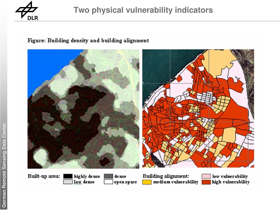
10 Physical vulnerability indicators Building density Road width (accessibility) Open spaces Location (distance to major road) Building alignment Terrain situation Future goal: Building height, socio.economic parameter

11 Vulnerability assessment map

12 AC Questionaire: 1. Demographic Information Built-up Population distribution Population structure Shadow Lawn 2. Economic Information Financial situation Car ownership Insurance Bushes Roads Water Allocation of built-up areas High density Dense Low density Open spaces 3. Social Information Education

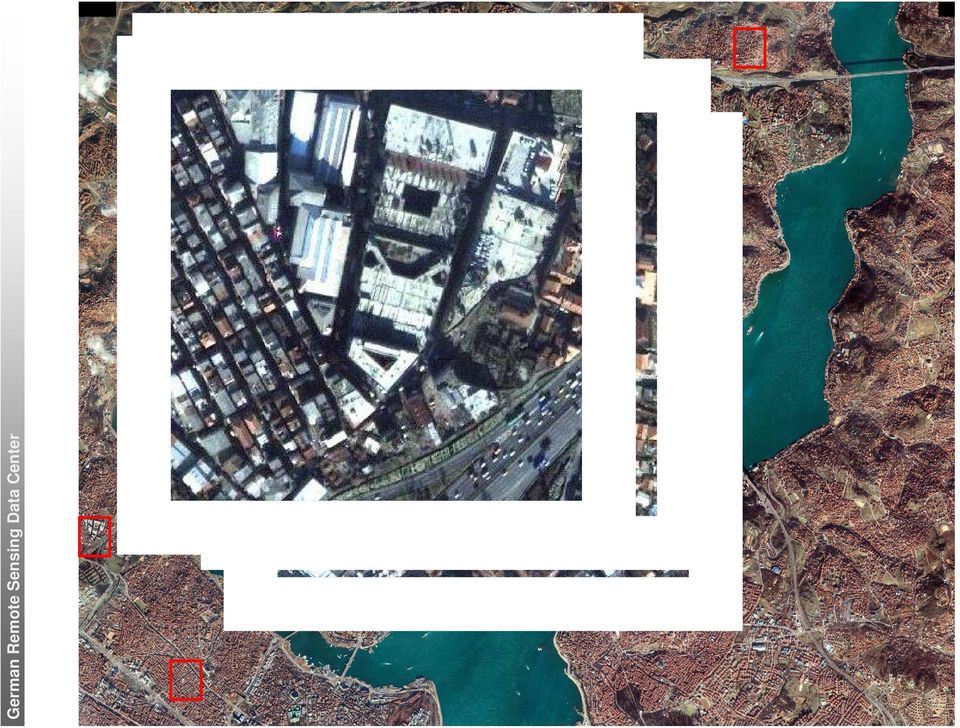
13 Assessment of location factors Example site in central Üsküdar Thematic classes: built-up areas shadows lawn trees/bushes main roads water

14 3. Assessment of location factors Location factors Densities Population Location For example location in Üsküdar Homogeneous Zone Vegetation rate Built-up rate Central high dense built-up area Inhabitants/km² 5 % 50 % Absolute number of inhabitants in 2.5 km ring 17, ,000 10,000 Day population/km² Distance to centre of Üsküdar Distance to superior road Distance to CBD Istanbul Terrain Open spaces analysis 0 km 2,2 km 5 km Height 58 m 3 % Portion of open spaces in 2.5 km ring Inclination 16 % 60,2 % Proportion from open spaces < 10 % slope Accurracy assessment: Complete Üsküdar population distribution: Inhabitants / km² Highly dense: Inhabitants / km² - low dense: Inhabitants / km² Source: Wikipedia - assessed by RS

15 Conclusion and perspective Conclusion: Remote sensing can provide area-wide, up-to-date information for an assessment of vulnerability Perpective: Derivation of further indicators: 4 Building height 4 Socio-economic parameters 4. Final goal: Area-wide vulnerability map for the test-site Istanbul

How can we defend ourselves from the hazard of Nature in the modern society?
 How can we defend ourselves from the hazard of Nature in the modern society?, University of Bologna President of the EGU Division of Natural Hazards Email: [email protected] [email protected] GIFT 2013 Natural
German Earth Observation Systems and Programs Capacities for nation building
 German Earth Observation Systems and Programs Capacities for nation building German Aerospace Center, DLR, Earth Observation Center, EOC German Remote Sensing Data Center, DFD Gunter Schreier Deputy Director
Understanding Raster Data
 Introduction The following document is intended to provide a basic understanding of raster data. Raster data layers (commonly referred to as grids) are the essential data layers used in all tools developed
Comparison of ALOS-PALSAR and TerraSAR-X Data in terms of Detecting Settlements First Results
 ALOS 2008 Symposium, 3-7 November Rhodes, Greece Comparison of ALOS-PALSAR and TerraSAR-X Data in terms of Detecting Settlements First Results Thomas Esch*, Achim Roth*, Michael Thiel, Michael Schmidt*,
PACIFIC CATASTROPHE RISK ASSESSMENT AND FINANCING INITIATIVE
 PACIFIC CATASTROPHE RISK ASSESSMENT AND FINANCING INITIATIVE NIUE SEPTEMBER 11 COUNTRY RISK PROFILE: NIUE Niue is expected to incur, on average,.9 million USD per year in losses due to earthquakes and
CEDIM Forensic Disaster Analysis Group & CATDAT and Earthquake-Report.com. Philippines (Bohol) Earthquake Report #2
 Earthquake Report #2") CEDIM Forensic Disaster Analysis Group & CATDAT and Earthquake-Report.com Philippines (Bohol) Earthquake Report #2 Report Contributors: James Daniell (Earthquake Report & KIT); Armand Vervaeck, Carlos
CEDIM Forensic Disaster Analysis Group & CATDAT and Earthquake-Report.com Philippines (Bohol) Earthquake Report #2 Report Contributors: James Daniell (Earthquake Report & KIT); Armand Vervaeck, Carlos
HIGH RESOLUTION REMOTE SENSING AND GIS FOR URBAN ANALYSIS: CASE STUDY BURITIS DISTRICT, BELO HORIZONTE, MINAS GERAIS
 HIGH RESOLUTION REMOTE SENSING AND GIS FOR URBAN ANALYSIS: CASE STUDY BURITIS DISTRICT, BELO HORIZONTE, MINAS GERAIS Hermann Johann Heinrich Kux Senior Researcher III INPE, Remote Sensing Division DAAD
EMTA BAROMETER OF PUBLIC TRANSPORT IN EUROPEAN METROPOLITAN AREAS (2004)
") EMTA BAROMETER OF PUBLIC TRANSPORT IN EUROPEAN METROPOLITAN AREAS (2004) July 2007 Presentation EMTA is the association of European Metropolitan Transport Authorities that brings together the public authorities
EMTA BAROMETER OF PUBLIC TRANSPORT IN EUROPEAN METROPOLITAN AREAS (2004) July 2007 Presentation EMTA is the association of European Metropolitan Transport Authorities that brings together the public authorities
Coping with Natural Disasters in Japanese Urban Planning: How to Build Disaster Resilient Cities?
 Prof. Dr. Uta Hohn Ruhr-University Bochum 17th Japanese-German Symposium: Natural Disasters: Impact and Management Coping with Natural Disasters in Japanese Urban Planning: How to Build Disaster Resilient
Natural Disasters & Assessing Hazards and Risk. Natural Hazards and Natural Disasters
 Page 1 of 9 EENS 3050 Tulane University Natural Disasters Prof. Stephen A. Nelson Natural Disasters & Assessing Hazards and Risk This page last updated on 19-Aug-2014 Natural Hazards and Natural Disasters
Pacific Catastrophe Risk Assessment and Financing Initiative. Better Information for Smarter Investments
 Pacific Catastrophe Risk Assessment and Financing Initiative Better Information for Smarter Investments Main Outputs Pacific disaster risk assessment Probabilistic assessment of major perils Pacific Risk
Developing Interoperable Geographic Data Model for the Mitigation Phase of Disaster Management
 Developing Interoperable Geographic Data Model for the Mitigation Phase of Disaster Management Assoc. Prof. Dr. Arif Cagdas AYDINOGLU (Gebze Technical University, Dept. Of Geomatics Engineering, Turkey)
Development and Recovering From Disaster
 Development and Recovering From Disaster [email protected] International Symposium on Disaster Economics 3-5 April 2013, Istanbul Natural Disaster in Turkey Other disasters 4% Avalanche 2% Multiple
Planning for bushfire risk in a changing climate: Ku-ring-gai Council action
 Council Name Web Address Size Planning for bushfire risk in a changing climate: Ku-ring-gai Council www.kmc.nsw.gov.au 82 sq. km Population 101,083 (2006) Awards 1. Background 1.1 Council profile Ku-ring-gai
Keynote 2: What is Landslide Hazard? Inventory Maps, Uncertainty, and an Approach to Meeting Insurance Industry Needs
 Keynote 2: What is Landslide Hazard? Inventory Maps, Uncertainty, and an Approach to Meeting Insurance Industry Needs Jeffrey R Keaton Richard J Roth, Jr Amec Foster Wheeler Los Angeles, USA Consulting
HAZARD VULNERABILITY & RISK ASSESSMENT
 Hazard Vulnerability Analysis Purpose and Scope A Hazard Vulnerability Analysis (HVA) evaluates risk associated with a specific hazard. During this analysis, the hazard is evaluated for its probability
CHAPTER SEISMIC RISK MITIGATION PRACTICES IN SCHOOL BUILDINGS IN ISTANBUL, TURKEY
 CHAPTER 13 SEISMIC RISK MITIGATION PRACTICES IN SCHOOL BUILDINGS IN ISTANBUL, TURKEY Özal Yüzügüllü, Gülay Barbarosoglu and Mustafa Erdik Kandilli Observatory and Earthquake Research Institute Bogaziçi
Natural Disaster Impact on Business and Communities in Taiwan. Dr. Chung-Sheng Lee. NCDR Chinese Taipei
 Natural Disaster Impact on Business and Communities in Taiwan Dr. Chung-Sheng Lee NCDR Chinese Taipei 1 Brief Introduction of NCDR 2 Organizational Chart of NCDR NDPPC: National Disaster Preparation and
Contents. Specific and total risk. Definition of risk. How to express risk? Multi-hazard Risk Assessment. Risk types
 Contents Multi-hazard Risk Assessment Cees van Westen United Nations University ITC School for Disaster Geo- Information Management International Institute for Geo-Information Science and Earth Observation
Urban Land Use Data for the Telecommunications Industry
 Urban Land Use Data for the Telecommunications Industry Regine Richter, Ulla Weingart & Tobias Wever GAF AG Arnulfstr. 197 D-80634 Munich & Ulrike Kähny E-Plus Mobilfunk GmbH & Co. KG E-Plus Platz D-40468
Disaster and Emergency Management Activities in Turkey
 Muhammed SAHIN, Himmet KARAMAN, Turan ERDEN, Turkey Key words: Disaster and Emergency Management, Loss Estimation, TABIS, Earthquake SUMMARY After the two devastating earthquakes in the Marmara Region
Increasing Urban Disaster Resilience in Tokyo
 Ver.17 Increasing Urban Disaster Resilience in Tokyo Tetsuro FUJISAKI Deputy Director, Disaster Prevention city planning Section Bureau of Urban Development Tokyo Metropolitan Government Tokyo s Approach
HAZARD MAPPING, RISK ASSESSMENT, AND INSURANCE COVERAGE OF NATURAL CATASTROPHE RISK
 SESSION III HAZARD MAPPING, RISK ASSESSMENT, AND INSURANCE COVERAGE OF NATURAL CATASTROPHE RISK Mr. Sumarjono Insurance Bureau of The Ministry of Finance of the Republic of Indonesia Geological Position
4.14 Netherlands. Interactive flood risk map of a part of the province of Gelderland in the Netherlands. Atlas of Flood Maps
 4.14 Netherlands The Netherlands is flood prone for about 60% of its surface. 95 so-called dike-rings protect the polders from being flooded from the North Sea, rivers or lakes. The protection level has
TERMS OF REFERENCE FOR THE RAPID EIA STUDY
 TERMS OF REFERENCE FOR THE RAPID EIA STUDY 1 SUMMARY OF EIA METHODOLOGY STEP I : SCOPING OF THE ASSESSMENT Own with prevailing regulatory setting and criteria Identification of Environmental Assessment
PROPOSED TERMS OF REFERENCE
 Annexure-IV PROPOSED TERMS OF REFERENCE 1.0 Proposed Scope of Work for EIA Study The components of the EIA study include: Detailed description of all elements of the project activities (existing and proposed
2015 Global Risk Assessment. Sahar Safaie Program Officer, UNISDR Risk Knowledge Section
 2015 Global Risk Assessment Sahar Safaie Program Officer, UNISDR Risk Knowledge Section Outline Global Assessment Report (GAR) evolution Global Risk Assessment for GAR15 Objective Scope Audience/Users
The Use of Geographic Information Systems in Risk Assessment
 The Use of Geographic Information Systems in Risk Assessment With Specific Focus on the RiVAMP Methodology Presented by Nadine Brown August 27, 2012 Climate Studies Group Mona Climate Change Workshop Presentation
Indonesian National Network on Disaster Resource Partnership (DRP)
") 2011/EPWG/WKSP/021 Session 4 Indonesian National Network on Disaster Resource Partnership (DRP) Submitted by: Indonesia Workshop on Private Sector Emergency Preparedness Sendai, Japan 1-3 August 2011 Presentation
2011/EPWG/WKSP/021 Session 4 Indonesian National Network on Disaster Resource Partnership (DRP) Submitted by: Indonesia Workshop on Private Sector Emergency Preparedness Sendai, Japan 1-3 August 2011 Presentation
Urban Regeneration as Post Disaster Rehabilitation / Reconstruction of Historic Core City and Settlements
 Urban Regeneration as Post Disaster Rehabilitation / Reconstruction of Historic Core City and Settlements Surya Bhakta Sangachhe NSET, 3 PERM, Program Manager [email protected] ABSTRACT The impacts
Commercial Property Insurance & Modelling and Pricing of Commercial Property
 Commercial Property Insurance & Modelling and Pricing of Commercial Property Insurance A.Sertem Demir Commercial and Corporate Lines Underwriting Coordinator Zurich Sigorta Huge potential to grow in Emerging
RELATIONSHIP OF NATURE AND LIVING
 3 RELATIONSHIP OF NATURE AND LIVING The vicinity of sea and abundance of natural and cultural landscapes are clear assets of Greater Helsinki. Good utilisation of that asset warrants a regional landscape
CityGML goes to Broadway
 CityGML goes to Broadway Thomas H. Kolbe, Barbara Burger, Berit Cantzler Chair of Geoinformatics [email protected] September 11, 2015 Photogrammetric Week 2015, Stuttgart The New York City Open Data
Earthquake hazard mapping for community resilience in Japan
 Earthquake hazard mapping for community resilience in Japan -the role of the government- Understanding Risk Forum Focus day session Let s shake your community earthquake hazard mapping approach for community
UPDATING OBJECT FOR GIS DATABASE INFORMATION USING HIGH RESOLUTION SATELLITE IMAGES: A CASE STUDY ZONGULDAK
 UPDATING OBJECT FOR GIS DATABASE INFORMATION USING HIGH RESOLUTION SATELLITE IMAGES: A CASE STUDY ZONGULDAK M. Alkan 1, *, D. Arca 1, Ç. Bayik 1, A.M. Marangoz 1 1 Zonguldak Karaelmas University, Engineering
Smart City Resilience Learning from Emergency Response and Coordination in Japan
 Smart City Resilience Learning from Emergency Response and Coordination in Japan Executive Summary Cities worldwide are placing increasing importance on building up resilience to natural disasters, such
Traffic Management for a Smarter City:Istanbul Istanbul Metropolitan Municipality
 Traffic Management for a Smarter City:Istanbul Istanbul Metropolitan Municipality Traffic Management for a Smarter City: Istanbul There is no doubt for Traffic Management to be an issue in a crowded city
ESTIMATING THE COSTS OF EMERGENCY SERVICES DURING FLOOD EVENTS
 C. Pfurtscheller R. Schwarze ESTIMATING THE COSTS OF EMERGENCY SERVICES DURING FLOOD EVENTS Funding Project Management Coordination Agenda Introduction Emergency costs State of the art Flooding of 2005
RESOURCE EFFICIENCY SCOREBOARD DATA CENTRE ON NATURAL RESOURCES
 RESOURCE EFFICIENCY SCOREBOARD DATA CENTRE ON NATURAL RESOURCES NETGREEN thematic policy workshop 'Maximizing resource efficiency throughout the EU economy' 11 March 2015, CEPS, Brussels Evi Ford-Alexandraki
National Hazard and Risk Model (No-HARM) Wildfire
 Wildfire") National Hazard and Risk Model (No-HARM) Wildfire A Briefing Paper Anchor Point Group LLC 2131 Upland Ave. Boulder, CO 80304 (303) 665-3473 www.anchorpointgroup.com Summary The potential for wildfire-caused
National Hazard and Risk Model (No-HARM) Wildfire A Briefing Paper Anchor Point Group LLC 2131 Upland Ave. Boulder, CO 80304 (303) 665-3473 www.anchorpointgroup.com Summary The potential for wildfire-caused
Pipeline Routing using GIS and Remote Sensing Tobenna Opara Ocean Engineering Department University of Rhode Island [email protected].
 Pipeline Routing using GIS and Remote Sensing Tobenna Opara Ocean Engineering Department University of Rhode Island [email protected] Pipelines are utilized by the oil and gas industry to transport
Date, Time and Place: Presented by: Presented to: 22 August 2013, 0900 hrs, Pier 1 The Embarcadero, San Francisco
 Date, Time and Place: 22 August 2013, 0900 hrs, Pier 1 The Embarcadero, San Francisco Presented by: Nick Rogers, Mike Jacka, Kate Williams, Sjoerd van Ballegooy and Rick Wentz, Tonkin & Taylor International
Integrated Earthquake Risk Assessment
 Socio- Vulnerability Index for Risk Analysis Mohsen Ghafory-Ashtiany Affiliated Faculty: Disaster Management Research Institute of Shakhes Pajooh Professor: International Institute of Earthquake Engineering
Introduction of the Project
 The Project on Urban Transport Improvement in Federal Democratic Republic of Nepal July, 2015 Introduction of the Project Government of Nepal Ministry of Physical Infrastructure and Transport (MOPIT) Department

Urban Transport Issues in Egypt
 Urban Transport Issues in Egypt Prof. Dr. Khaled El Araby Chair Professor of Transport Planning and Traffic Engineering, Faculty of Engineering, Ain Shams University, Cairo, Egypt International Symposium
Anchorage All-Hazard Mitigation Plan October 2004
 EXECUTIVE SUMMARY The Municipality of Anchorage (MOA) is vulnerable to a wide range of natural, technological, and human/societal hazards including earthquakes, avalanches, and hazardous material accidents.
RAPID-N: A Natech risk assessment and mapping tool
 RAPID-N: A Natech risk assessment and mapping tool S. Girgin, E. Krausmann European Commission, Joint Research Centre Institute for the Protection and Security of the Citizen Ispra, Italy Serving society
Predicting Seismic Vulnerable Zones using GIS. Outline of the presentation. Objectives. Risk Mapping Overview Factor Maps. Three levels of Zonation
 Predicting Seismic Vulnerable Zones using GIS by K.S.A. Dinesh Kumar Research Scholar, Anna University & Lecturer in Civil Engineering Dept. National Institute of Technical Teachers Training & Research
SYSTEM DESIGN OF DISASTER MANEGEMENT INFORMATION SYSTEM IN TURKEY AS A PART OF E-GOVERNMENT
 SYSTEM DESIGN OF DISASTER MANEGEMENT INFORMATION SYSTEM IN TURKEY AS A PART OF E-GOVERNMENT C. Eraslan a, Z. Alkis a, O. Emem a, C. Helvacı a, F. Batuk a, U. Gümüsay a, N. Demir a, T. Turk a, B. Bayram
World Tower. Company, Inc. Classification Overview. Categories: Structure Classification Exposure Categories Topographic Effects Geological
 Manufacturing Custom Fabricated Structures since 1979 Professional In-House Design Staff Tower Delivery Service World Tower Company, Inc. Classification Overview Categories: Structure Classification Exposure
Appendix J Online Questionnaire
 Appendix J Online Questionnaire In accordance with the Paperwork Reduction Act, this questionnaire was approved by the Office of Management and Budget (OMB). The OMB control number and expiration date
Survey and Mapping Activities in Vietnam *
 UNITED NATIONS E/CONF.100/CRP.1 ECONOMIC AND SOCIAL COUNCIL Eighteenth United Nations Regional Cartographic Conference for Asia and the Pacific Bangkok, 26-29 October 2009 Item 7(a) of the provisional
FAIR SHARED CITY: GENDER MAINSTREAMING PLANNING STRATEGY IN VIENNA: AUSTRIA.
 FAIR SHARED CITY: GENDER MAINSTREAMING PLANNING STRATEGY IN VIENNA: AUSTRIA. Fair Shared City: Gender Mainstreaming Planning Strategy in Vienna City of Vienna 1.6 million inhabitants, 23 districts, 415
Mapping and Modelling the Impact of Land Use Planning and Management Practices on Urban and Peri-Urban Landscapes in the Greater Dublin Area
 Mapping and Modelling the Impact of Land Use Planning and Management Practices on Urban and Peri-Urban Landscapes in the Greater Dublin Area Dr. Martin Critchley Era-Maptec Ltd 36 Dame Street Dublin 2
Chincha and Cañete, Peru, Based
 Reconstruction of Ica, Pisco, Chincha and Cañete, Peru, Based on Updated Hazard Maps Julio Kuroiwa Professor emeritus National University of Engineering and UNDP Reconstruction Program/Sustainable Cities.
Satellite and ground-based remote sensing for rapid seismic vulnerability assessment M. Wieland, M. Pittore
 Satellite and ground-based remote sensing for rapid seismic vulnerability assessment M. Wieland, M. Pittore Helmholtz Centre Potsdam GFZ German Research Centre for Geosciences Centre for Early Warning
Development of a remote sensing based land barometer for sustainable land use management
 Bilateral German-Polish REFINA workshop Research and model projects on suburbanization and land consumption Development of a remote sensing based land barometer for sustainable land use management Thomas
Application of Space Technology for Disaster monitoring and assessment current state in Vietnam
 Application of Space Technology for Disaster monitoring and assessment current state in Vietnam Lai Anh Khoi SPACE TECHNOLOGY INSTITUTE 8th GEOSS Asian Pacific Symposium Beijing, Sep. 09-11, 2015 Types
Natural Hazards 1.1. Natural Hazards. Objective: Natural Hazards in Western Australia Are we at risk? Page 1. Natural Hazards Years 5-7
 Natural Hazards 1.1 Engage Natural Hazards To introduce students to the natural hazards which occur in Western Australia and their risk. Western Australia experiences a range of natural hazards each year,
Planning should achieve high quality urban design and architecture that: Contributes positively to local urban character and sense of place.
 15 BUILT ENVIRONMENT AND HERITAGE 15/07/2013 VC100 Planning should ensure all new land use and development appropriately responds to its landscape, valued built form and cultural context, and protect places
Tools and Methods for Global Urban Analysis
 European Commission Joint Research Centre 1st Urbanization Workshop Day 2, Session 1: Tools and Methods for Global Urban Analysis Ellen Hamilton Lead Urban Specialist World Bank 1 Outline Global Agendas:
Landslides: The Poor Stepchild of GeoHazards; What We and Other Countries Can Do to Solve It! Scott Burns Portland State University Dept.
 Landslides: The Poor Stepchild of GeoHazards; What We and Other Countries Can Do to Solve It! Scott Burns Portland State University Dept. of Geology Afghanistan: 2014: 2700 dead West Salt Creek Landslide,
Hazard Identification and Risk Assessment
 Wildfires Risk Assessment This plan is an update of the 2004 City of Redmond Hazard Mitigation Plan (HMP). Although it is an update, this document has been redesigned so that it looks, feels, and reads
Development of an Urban Disaster Management System Based On a Geographical Information System
 Development of an Urban Disaster Management System Based On a Geographical Information System Kurtulus Erinc Akdogan, Volkan Caliskan, Mustafa Orcun Kara, Mehmet Bilgekagan Cintimur [email protected],
mega- cities in Latin America & Infrastructure what its people think
 mega- cities & Infrastructure in Latin America what its people think the latin american reality For more information: Please contact us at: [email protected] with comments, questions, or for
Possible ECHO Shelter Indicators (version 15/05/13) revised by EDB/MP & DH 13/06
 revised by EDB/MP & DH 13/06") Possible ECHO Shelter Indicators (version 15/05/13) revised by EDB/MP & DH 13/06 (at Results level) Sub-Sector/Key Results Indicator A) Strategic Planning: Shelter and settlement strategies to meet the
Possible ECHO Shelter Indicators (version 15/05/13) revised by EDB/MP & DH 13/06 (at Results level) Sub-Sector/Key Results Indicator A) Strategic Planning: Shelter and settlement strategies to meet the
Draft Model Earthquake Contingency Plan of Trinidad and Tobago DMECP. Presented by Denise Anderson
 Draft Model Earthquake Contingency Plan of Trinidad and Tobago DMECP Presented by Denise Anderson 1 Outline About the DMECP! Mitigation! Preparedness! Response! Recovery! Tsunami Countermeasures! The Way
Geo-information in The Hague & National SDI hub PDOK
 Geo-information in The Hague & National SDI hub PDOK dr.ir. Friso Penninga senior advisor at Municipality of The Hague & tactical advisor at Geonovum Contents 1. Introduction 2. GI in The Hague a. Overview
MAPPING MINNEAPOLIS URBAN TREE CANOPY. Why is Tree Canopy Important? Project Background. Mapping Minneapolis Urban Tree Canopy.
 MAPPING MINNEAPOLIS URBAN TREE CANOPY Why is Tree Canopy Important? Trees are an important component of urban environments. In addition to their aesthetic value, trees have significant economic and environmental
A DIACHRONIC STUDY ON THE URBAN GROWTH OF DAKAR YEAR 1988, 1998 AND 2007
 A DIACHRONIC STUDY ON THE URBAN GROWTH OF DAKAR YEAR 1988, 1998 AND 2007 Presented by DIALLO Ngagne PGD in GIS and Cartography Gis analyst in the Cadastre of Senegal Republic of Senegal Ministry of Economy
NATHAN world map of natural hazards. 2011 version
 world map of natural hazards 2011 version World Map of Natural Hazards Geointelligence for your business A new name but the recipe for success is the same: In the 2011 version, we are offering both proven
HIGHWAY DESIGN REPORT. Appendix 4. Proposed Design Principles for City Passings
 HIGHWAY DESIGN REPORT Appendix 4 Proposed Design Principles for City Passings June 2000 Contents Page 1 Introduction 2 1.1 Purpose 2 1.2 Definition of city passing 2 1.3 Safety Problems 2 1.4 Planning
DISASTERS & EMERGENCIES
 DISASTERS & EMERGENCIES DEFINITIONS Training Package WHO/EHA Panafrican Emergency Training Centre, Addis Ababa Updated March 2002 by EHA 1 WORLDWIDE Number of People Affected by Disasters Million 400 350
5-2. Dissemination of Earthquake Risk Reduction and Recovery Preparedness Model Programme
 5-2. Dissemination of Earthquake Risk Reduction and Recovery Preparedness Model Programme 5-2-1. Background Asian Region is the most disaster prone regions in the world. Many countries in the region are
SESSION 8: GEOGRAPHIC INFORMATION SYSTEMS AND MAP PROJECTIONS
 SESSION 8: GEOGRAPHIC INFORMATION SYSTEMS AND MAP PROJECTIONS KEY CONCEPTS: In this session we will look at: Geographic information systems and Map projections. Content that needs to be covered for examination
Plan Plus Volume 1 No 1 2002 (117-123)
") Plan Plus Volume 1 No 1 2002 (117-123) APPLICATION OF GIS (GEOGRAPHIC INFORMATION SYSTEM) FOR LANDSLIDE HAZARD ZONATION AND MAPPING DISASTER PRONE AREA: A STUDY OF KULEKHANI WATERSHED, NEPAL Purna Chandra
Plan Plus Volume 1 No 1 2002 (117-123) APPLICATION OF GIS (GEOGRAPHIC INFORMATION SYSTEM) FOR LANDSLIDE HAZARD ZONATION AND MAPPING DISASTER PRONE AREA: A STUDY OF KULEKHANI WATERSHED, NEPAL Purna Chandra
Urban Climatic Map of Arnhem City
 Urban Climatic Map of Arnhem City Renè Burghardt, Lutz Katzschner, Sebastian Kupski, University Kassel Ren Chao, Tejo Spit University Utrecht May 2010 1 1 INTRODUCTION In the framework of urban planning
Capturing building inventory data for earthquake risk assessment: The GEM perspective. Risk Global Component Inventory Data Capture Tools
 Risk Global Component Inventory Data Capture Tools Capturing building inventory data for earthquake risk assessment: The GEM perspective NCEO/CEOI Joint Science Conference, Nottingham 2/9/212 John Bevington,
DATA VISUALIZATION GABRIEL PARODI STUDY MATERIAL: PRINCIPLES OF GEOGRAPHIC INFORMATION SYSTEMS AN INTRODUCTORY TEXTBOOK CHAPTER 7
 DATA VISUALIZATION GABRIEL PARODI STUDY MATERIAL: PRINCIPLES OF GEOGRAPHIC INFORMATION SYSTEMS AN INTRODUCTORY TEXTBOOK CHAPTER 7 Contents GIS and maps The visualization process Visualization and strategies
Noise Abatement Political Background
 Noise Abatement Political Background Advanced Noise Reduction Rob Hofman Dienst Verkeer en Scheepvaart (DVS) 2 Netherlands 34.000 km 2 land Capital Amsterdam Population density 3 16 million inhabitants,
GEOMETRIC DESIGN CIVL 3161
 GEOMETRIC DESIGN CIVL 3161 Reading Assignment: p. 45-72 (4 th ed.) p.45-75 (previous ed.) in Mannering textbook. Geometric design of highway facilities deals with the proportion of physical elements of
Earthquake Disaster Recovery Plan in TMG
 Earthquake Disaster Recovery Plan in TMG Pre-disaster Management Measures by District and Recovery from Expected Earthquake Directly Underneath Tokyo Planning Section Urban Development Projects Division
Numerical Modeling Earthquake Effects On Sea Outfall Systems : Kadýköy Sea Outfall Case
 2 ND INTERNATIONAL CONFERENCE ON MARINE WASTE WATER DISCHARGES MWWD 2002 - I STANBUL SEPT. 16 20 Numerical Modeling Earthquake Effects On Sea Outfall Systems : Kadýköy Sea Outfall Case Prof.Dr. Sedat Kabdaþlý
The Importance of the Global C-band Allocation for Satellite Communications Services
 FOUNTAIN COURT, 2 VICTORIA SQ., ST ALBANS HERTFORDSHIRE, AL1 3TF, ENGLAND TELEPHONE:+1 202 390 1885 EMAIL: [email protected] WEBSITE: www.gvf.org The Importance of the Global C-band Allocation for
Multi-Hazard Disaster Risk Assessment (v2)
") Multi-Hazard Disaster Risk Assessment (v2) This How to Note is part of a series of Guidance Notes designed to assist DFID Country Offices in embedding disaster resilience in their country programmes. This
Multi-Hazard Disaster Risk Assessment (v2) This How to Note is part of a series of Guidance Notes designed to assist DFID Country Offices in embedding disaster resilience in their country programmes. This