HIGH RESOLUTION REMOTE SENSING AND GIS FOR URBAN ANALYSIS: CASE STUDY BURITIS DISTRICT, BELO HORIZONTE, MINAS GERAIS
|
|
|
- Ashlee Mavis Rogers
- 8 years ago
- Views:
Transcription
1 HIGH RESOLUTION REMOTE SENSING AND GIS FOR URBAN ANALYSIS: CASE STUDY BURITIS DISTRICT, BELO HORIZONTE, MINAS GERAIS Hermann Johann Heinrich Kux Senior Researcher III INPE, Remote Sensing Division DAAD Thematic Seminar Natural Hazards: Research on natural disasters, civil defense, disaster prevention, and aid Teresópolis, RJ, Brazil, June 15 th - 17 th 2012

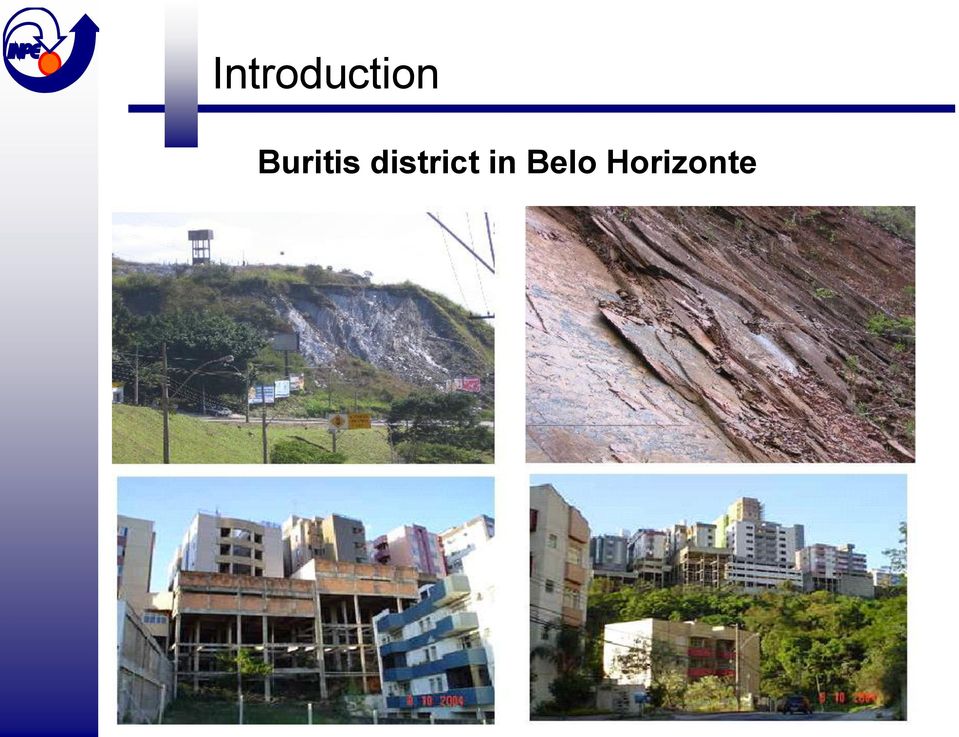
2 Introduction Some typical problems of metropolitan areas in Brazil: - Inadequate planning, not considering, among others, geo- technological characteristics of underground substratum; - Failure from local government on adequate control of constructions; - Strong financial speculation by private companies to raise the prices of real estate.

3 Introduction Buritis district in Belo Horizonte
4 Technical data sheet: Quickbird-2 satellite Launch: Oct. 18 th 2001 Expected life span : > 5 years Orbit: 97,2º sun-synchronous Orbit duration: 93,5 minutes Width of imaged area: 16,5 Km (nadir), 20,8 Km (off-nadir) Revisit time: 1 3,5 days according to latitude Spatial resolution: Panchromatic mode 61 cm at nadir, 72 cm at 25º Multispectral mode - 2,44 m at nadir, 2,88 m at 25º Radiometric resolution: 11 bits, 2048 gray levels Bands: Panchromatic: 0,45-0,90 µm Blue: 0,45-0,52 µm Green: 0,52-0,60 µm Red: 0,63-0,69 µm Near IR: 0,76-0,90 µm

5 Objectives of the case study To evaluate the use of digital analysis (OBIA approach) of high spatial resolution satellite images (Quickbird-2) and spatial inference methods in a critical urban area (Buritis), emphasizing its characteristics, specifics and limitations, in order to contribute with information to urban planning. Specific tasks: 1. Evaluation on the efficiency of geometric correction from Quickbird-2 images. 2. Evaluation on the precision of ortho-rectification from Quickbird- 2 images, applying a rigorous model and using terrestrial acquired D-GPS control points. 3. Evaluation on the performance of image classification using the OBIA (Object-based image analysis). 4. Evaluation on the integration of information extracted from Quickbird-2 images and other sources in a GIS, as a subsidy for urban planning.

6 Localization of test-site Buritis 2004 image Buritis Belvedere 2002 image Quickbird-2 images used, delivered by DIGITALGLOBE.

7 Methodology III Geometric correction D-GPS points (field survey) Features at both images Collection of coordinates by a D-GPS receiver

8 Methodology I Ortho-correction of Quickbird-2 image Definition of test-site Geometric correction Contours Ortho-images DEM Evaluation of precision Field survey D-GPS control points Information acquired Information generated

9 Methodology II Object-oriented analysis (OBIA) Area under study Geometric correction Object-oriented classification Edited ortho-images Classified images Edited cadastre Class definition; Multi-resolution segmentation; Hierarchy; Membership rules; Evaluation Evaluation: Kappa; Stability. Information generated

10 Methodology III Classification Definition of classes Classes Composition bands 3,2,1 RGB Composition bands 4,3,2 RGB Characteristics of interest Asphalt Use of urban cadastre. White cover High brightness, Constitution of materials not discernible. Gray cover Impervious. Cover of high buildings. Much variation.

11 Methodology III Classification Definition of classes (cont.) Flare Quantization level close to Swimming pool High response in the blue band. In some cases in the green band. Bare soil Modified terrain (earth works). No vegetation. Response in the red band. Shadow Low brightness. Close to high buildings and arboreal vegetation.
. No vegetation. Response in the red band.")
12 Methodology III Classification Definition of classes (cont.) Ceramic tile Linear borders. Standardized according to legislation. Variable geometry. Response in the red band. Arboreal vegetation High response in the NIR. Texture due to different height of trees (shadow). Grass vegetation High response in the NIR. Uniform. Response in the red band (soil).
.")
13 Methodology IV Spatial inferences Definition of area under study Information acquired Info. generated Ortho-rectification Object-oriented classification Spatial inferences Data preparation Classified images Geology Geotechnical map Geologic risks Urban expansion Landslides Irregular constructions Critical areas Injury/losses f. population Legislation

14 Methodology V Spatial inferences Data preparation Geologic map Adaptation from geologic map of Belo Horizonte; Simplification; Field survey. Map of geologic risks Edited from original in digital format; Map of legislation Adapted f. Law on Potential Land Use (LEIPUOS); Slope map Generated from DEM; Interest on intervals limited by Law. Map of slope orientation Generated from DEM; Interest on slopes oriented to SE.
; Slope map Generated from DEM; Interest on intervals limited by Law.")
15 Methodology VI Spatial inferences Injury/losses for population Geologic risks associated Permissive Zoning Critical areas Classifications LEIPUOS Slopes Areas available for construction High geologic risks Spatial Inference - AHP Injury/losses f. population Information acquired Information generated

16 Results I Geometric correction Ortho-rectification Image without correction 2004 Corrected image 2004 RMS = 14,48m RMS = 0,86m

17 Results III Classification Buritis district (2004) Red Source: Araújo (2006)
 Red Source:")
18 Results IV Classification Confusion matrix Source: Araújo (2006).

19 Results V Inferences Risk of landslides Buritis Belvedere High Medium Low Nil Source: Araújo (2006)

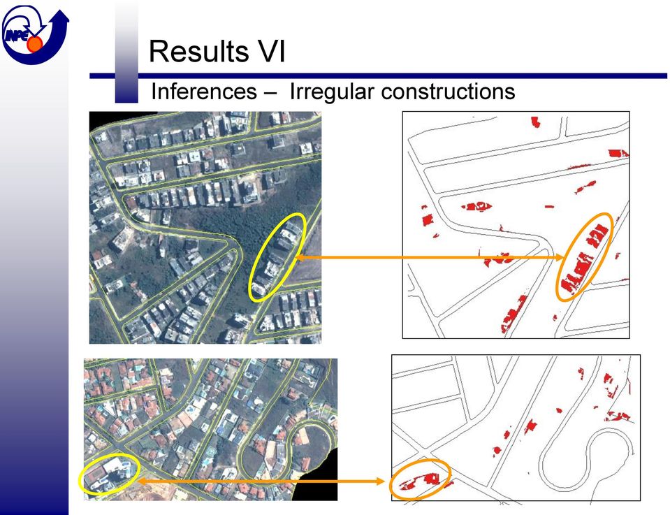
20 Results VI Inferences Irregular constructions
21 Conclusions High resolution satellite images, such as QuickBird-2, and since 2009 WorldView-2, allow detailed mapping of urban growth, with emphasis on the construction at critical areas. The Object-based image analysis (OBIA) approach is of fundamental importance to obtain reliable classification results, to be stored in a data base, for a yearly multi-temporal analysis. As for the test site Buritis district, all geological and geotechnical risks mentioned (and known since a long time!) were not taken into account both by the construction companies of buildings and by the municipal authorities. Due to such a behavior in 2011 a tragedy occurred in Buritis..!
22 Injury / Losses for population Tragedy at Buritis district in Belo Horizonte Bang in edifices surrounding the condemned building panic inhabitants. Civil Defense alerts that glasses, doors and windows can break in a radius of 800 m from the condemned building, in case of collapse. Source: Do Hoje em Dia, Oct. 30 th 2011, 18:14 h. Which building will be the next to collapse...?
23 Localization of collapsed buildings in Buritis Places condemned by Civil Defense Low Vulnerability High
24 References (selection) ARAÚJO, E.H.G. Análise multi-temporal de cenas do satélite Quickbird usando um novo paradigma de classificação de imagens e inferências espaciais: estudo de caso Belo Horizonte (MG), 159 p. 2006, Mestrado em Sensoriamento Remoto, INPE, São José dos Campos, available at: ARAÚJO, E.H.G., KUX, H.J.H., FLORENZANO, T.G. Análise multi-temporal de dois bairros de Belo Horizonte (MG) usando classificação orientada a objetos de imagens Quickbird e inferências espaciais. In: BLASCHKE, T. & KUX, H. (editores) Sensoriamento Remoto e SIG avançados, 2ª edição, Oficina de Textos Ltda., São Paulo 2007, pp ARAÚJO, E.H.G., KUX, H.J.H., FLORENZANO, T.G. Ortorretificação de imagens do satélite Quickbird para aplicações urbanas, Revista Brasileira de Cartografia, vol. 60/2, Agosto 2008, pp , available at: KUX, H.J.H. & ARAÚJO, E.H.G. Object-based image analysis using Quickbird images and GIS data, case study Belo Horizonte (Brazil). In: T. Blaschke, S. Lang, G.J. Hay (editors) Object-based image analysis spatial concepts for knowledge-driven Remote Sensing Applications, SPRINGER Verlag, Berlin/Heidelberg 2008, pp
25 Thanks for your attention! Danke für ihre Aufmerksamkeit! Contact: Telephone:
INTRA-URBAN LAND COVER CLASSIFICATION FROM HIGH-RESOLUTION IMAGES USING THE C4.5 ALGORITHM
 INTRA-URBAN LAND COVER CLASSIFICATION FROM HIGH-RESOLUTION IMAGES USING THE C4.5 ALGORITHM C. M. D. Pinho a, F. C. Silva a, L. M. C. Fonseca, *, A. M. V. Monteiro a a Image Processing Division, Brazil's
APPLYING SATELLITE IMAGES CLASSIFICATION ALGORITHMS FOR SOIL COVER AND GEORESOURCES IDENTIFICATION IN NOVA LIMA, MINAS GERAIS - BRAZIL
 APPLYING SATELLITE IMAGES CLASSIFICATION ALGORITHMS FOR SOIL COVER AND GEORESOURCES IDENTIFICATION IN NOVA LIMA, MINAS GERAIS - BRAZIL Vladimir Diniz Vieira Ramos Universidade Federal de Minas Gerais Departamento
An Assessment of the Effectiveness of Segmentation Methods on Classification Performance
 An Assessment of the Effectiveness of Segmentation Methods on Classification Performance Merve Yildiz 1, Taskin Kavzoglu 2, Ismail Colkesen 3, Emrehan K. Sahin Gebze Institute of Technology, Department
RULE INHERITANCE IN OBJECT-BASED IMAGE CLASSIFICATION FOR URBAN LAND COVER MAPPING INTRODUCTION
 RULE INHERITANCE IN OBJECT-BASED IMAGE CLASSIFICATION FOR URBAN LAND COVER MAPPING Ejaz Hussain, Jie Shan {ehussain, jshan}@ecn.purdue.edu} Geomatics Engineering, School of Civil Engineering, Purdue University
HIGH SPATIAL RESOLUTION IMAGES - A NEW WAY TO BRAZILIAN'S CARTOGRAPHIC MAPPING
 CO-192 HIGH SPATIAL RESOLUTION IMAGES - A NEW WAY TO BRAZILIAN'S CARTOGRAPHIC MAPPING BIAS E., BAPTISTA G., BRITES R., RIBEIRO R. Universicidade de Brasíia, BRASILIA, BRAZIL ABSTRACT This paper aims, from
Resolutions of Remote Sensing
 Resolutions of Remote Sensing 1. Spatial (what area and how detailed) 2. Spectral (what colors bands) 3. Temporal (time of day/season/year) 4. Radiometric (color depth) Spatial Resolution describes how
SAMPLE MIDTERM QUESTIONS
 Geography 309 Sample MidTerm Questions Page 1 SAMPLE MIDTERM QUESTIONS Textbook Questions Chapter 1 Questions 4, 5, 6, Chapter 2 Questions 4, 7, 10 Chapter 4 Questions 8, 9 Chapter 10 Questions 1, 4, 7
Information Contents of High Resolution Satellite Images
 Information Contents of High Resolution Satellite Images H. Topan, G. Büyüksalih Zonguldak Karelmas University K. Jacobsen University of Hannover, Germany Keywords: satellite images, mapping, resolution,
Spectral Response for DigitalGlobe Earth Imaging Instruments
 Spectral Response for DigitalGlobe Earth Imaging Instruments IKONOS The IKONOS satellite carries a high resolution panchromatic band covering most of the silicon response and four lower resolution spectral
PIMAR PROJECT - MONITORING THE ATLANTIC RAINFOREST REMNANTS AND THE URBAN GROWTH OF THE RIO DE JANEIRO CITY (BRAZIL) THROUGH REMOTE SENSING
 THROUGH REMOTE SENSING") PIMAR PROJECT - MONITORING THE ATLANTIC RAINFOREST REMNANTS AND THE URBAN GROWTH OF THE RIO DE JANEIRO CITY (BRAZIL) THROUGH REMOTE SENSING D. P. Cintra a, *, T. Novack b, L. F. G. Rego a, G. A. O. P.
PIMAR PROJECT - MONITORING THE ATLANTIC RAINFOREST REMNANTS AND THE URBAN GROWTH OF THE RIO DE JANEIRO CITY (BRAZIL) THROUGH REMOTE SENSING D. P. Cintra a, *, T. Novack b, L. F. G. Rego a, G. A. O. P.
Object-Oriented Approach of Information Extraction from High Resolution Satellite Imagery
 IOSR Journal of Computer Engineering (IOSR-JCE) e-issn: 2278-0661,p-ISSN: 2278-8727, Volume 17, Issue 3, Ver. IV (May Jun. 2015), PP 47-52 www.iosrjournals.org Object-Oriented Approach of Information Extraction
MULTIPURPOSE USE OF ORTHOPHOTO MAPS FORMING BASIS TO DIGITAL CADASTRE DATA AND THE VISION OF THE GENERAL DIRECTORATE OF LAND REGISTRY AND CADASTRE
 MULTIPURPOSE USE OF ORTHOPHOTO MAPS FORMING BASIS TO DIGITAL CADASTRE DATA AND THE VISION OF THE GENERAL DIRECTORATE OF LAND REGISTRY AND CADASTRE E.ÖZER, H.TUNA, F.Ç.ACAR, B.ERKEK, S.BAKICI General Directorate
detection of Shaded Roads in urban Areas
 Detection of shaded roads in high spatial resolution images of urban areas Thiago Statella 1 Federal Institute for Education, Science and Technology of Mato Grosso, Zulmira Canavarros street n 95, Cuiabá,
Remote Sensing of Environment
 Remote Sensing of Environment 115 (2011) 1145 1161 Contents lists available at ScienceDirect Remote Sensing of Environment journal homepage: www.elsevier.com/locate/rse Per-pixel vs. object-based classification
China Earth Observation
 China High-resolution Earth Observation China Earth Observation System (CHEOS) and its Lastest Development The Earth Observation System and Data Center, CNSA 2014-2 Outlines 1 Introduction 2 The composition
The RapidEye optical satellite family for high resolution imagery
 'Photogrammetric Week 01' D. Fritsch & R. Spiller, Eds. Wichmann Verlag, Heidelberg 2001. Scherer, Krischke 139 The RapidEye optical satellite family for high resolution imagery STEFAN SCHERER and MANFRED
2.3 Spatial Resolution, Pixel Size, and Scale
 Section 2.3 Spatial Resolution, Pixel Size, and Scale Page 39 2.3 Spatial Resolution, Pixel Size, and Scale For some remote sensing instruments, the distance between the target being imaged and the platform,
Digital Classification and Mapping of Urban Tree Cover: City of Minneapolis
 Digital Classification and Mapping of Urban Tree Cover: City of Minneapolis FINAL REPORT April 12, 2011 Marvin Bauer, Donald Kilberg, Molly Martin and Zecharya Tagar Remote Sensing and Geospatial Analysis
THEMATIC ACCURACY ASSESSMENT FOR OBJECT BASED CLASSIFICATION IN AGRICULTURE AREAS: COMPARATIVE ANALYSIS OF SELECTED APPROACHES
 THEMATIC ACCURACY ASSESSMENT FOR OBJECT BASED CLASSIFICATION IN AGRICULTURE AREAS: COMPARATIVE ANALYSIS OF SELECTED APPROACHES J. Chmiel, A. Fijałkowska Warsaw University of Technology, Faculty of Geodesy
Supervised Classification workflow in ENVI 4.8 using WorldView-2 imagery
 Supervised Classification workflow in ENVI 4.8 using WorldView-2 imagery WorldView-2 is the first commercial high-resolution satellite to provide eight spectral sensors in the visible to near-infrared
The Role of SPOT Satellite Images in Mapping Air Pollution Caused by Cement Factories
 The Role of SPOT Satellite Images in Mapping Air Pollution Caused by Cement Factories Dr. Farrag Ali FARRAG Assistant Prof. at Civil Engineering Dept. Faculty of Engineering Assiut University Assiut, Egypt.
Changes in forest cover applying object-oriented classification and GIS in Amapa- French Guyana border, Amapa State Forest, Module 4
 Changes in forest cover applying object-oriented classification and GIS in Amapa- French Guyana border, Amapa State Forest, Module 4 Marta Vieira da Silva 1 Valdenira Ferreira dos Santos 2 Eleneide Doff
Landsat Monitoring our Earth s Condition for over 40 years
 Landsat Monitoring our Earth s Condition for over 40 years Thomas Cecere Land Remote Sensing Program USGS ISPRS:Earth Observing Data and Tools for Health Studies Arlington, VA August 28, 2013 U.S. Department
Adaptation of High Resolution Ikonos Images to Googleearth for Zonguldak Test Field
 Adaptation of High Resolution Ikonos Images to Googleearth for Zonguldak Test Field Umut G. SEFERCIK, Murat ORUC and Mehmet ALKAN, Turkey Key words: Image Processing, Information Content, Image Understanding,
From Ideas to Innovation
 From Ideas to Innovation Selected Applications from the CRC Research Lab in Advanced Geomatics Image Processing Dr. Yun Zhang Canada Research Chair Laboratory in Advanced Geomatics Image Processing (CRC-AGIP
Remote Sensing in Natural Resources Mapping
 Remote Sensing in Natural Resources Mapping NRS 516, Spring 2016 Overview of Remote Sensing in Natural Resources Mapping What is remote sensing? Why remote sensing? Examples of remote sensing in natural
Using Remote Sensing Imagery to Evaluate Post-Wildfire Damage in Southern California
 Graham Emde GEOG 3230 Advanced Remote Sensing February 22, 2013 Lab #1 Using Remote Sensing Imagery to Evaluate Post-Wildfire Damage in Southern California Introduction Wildfires are a common disturbance
Recent advances in Satellite Imagery for Oil and Gas Exploration and Production. DESK AND DERRICK APRIL 2016 PRESENTED BY GARY CREWS---RETIRED
 Recent advances in Satellite Imagery for Oil and Gas Exploration and Production. DESK AND DERRICK APRIL 2016 PRESENTED BY GARY CREWS---RETIRED Agenda Brief review of state of the applications in 2010 Basics
Research On The Classification Of High Resolution Image Based On Object-oriented And Class Rule
 Research On The Classification Of High Resolution Image Based On Object-oriented And Class Rule Li Chaokui a,b, Fang Wen a,b, Dong Xiaojiao a,b a National-Local Joint Engineering Laboratory of Geo-Spatial
Core Imagery Product Guide. v. 2.0
 Core Imagery Product Guide v. 2.0 Disclaimer & Copyright Copyright 2014 DigitalGlobe, Inc. All rights reserved. The DigitalGlobe s Core Imagery Product Guide is purposely designed as a general guideline
CBERS Program Update Jacie 2011. Frederico dos Santos Liporace AMS Kepler liporace@amskepler.com
 CBERS Program Update Jacie 2011 Frederico dos Santos Liporace AMS Kepler liporace@amskepler.com Overview CBERS 3 and 4 characteristics Differences from previous CBERS satellites (CBERS 1/2/2B) Geometric
The premier software for extracting information from geospatial imagery.
 Imagery Becomes Knowledge ENVI The premier software for extracting information from geospatial imagery. ENVI Imagery Becomes Knowledge Geospatial imagery is used more and more across industries because
ENVI THE PREMIER SOFTWARE FOR EXTRACTING INFORMATION FROM GEOSPATIAL IMAGERY.
 ENVI THE PREMIER SOFTWARE FOR EXTRACTING INFORMATION FROM GEOSPATIAL IMAGERY. ENVI Imagery Becomes Knowledge ENVI software uses proven scientific methods and automated processes to help you turn geospatial
DEVELOPMENT OF A SUPERVISED SOFTWARE TOOL FOR AUTOMATED DETERMINATION OF OPTIMAL SEGMENTATION PARAMETERS FOR ECOGNITION
 DEVELOPMENT OF A SUPERVISED SOFTWARE TOOL FOR AUTOMATED DETERMINATION OF OPTIMAL SEGMENTATION PARAMETERS FOR ECOGNITION Y. Zhang* a, T. Maxwell, H. Tong, V. Dey a University of New Brunswick, Geodesy &
Nature Values Screening Using Object-Based Image Analysis of Very High Resolution Remote Sensing Data
 Nature Values Screening Using Object-Based Image Analysis of Very High Resolution Remote Sensing Data Aleksi Räsänen*, Anssi Lensu, Markku Kuitunen Environmental Science and Technology Dept. of Biological
Multiscale Object-Based Classification of Satellite Images Merging Multispectral Information with Panchromatic Textural Features
 Remote Sensing and Geoinformation Lena Halounová, Editor not only for Scientific Cooperation EARSeL, 2011 Multiscale Object-Based Classification of Satellite Images Merging Multispectral Information with
Preface. Ko Ko Lwin Division of Spatial Information Science University of Tsukuba 2008
 1 Preface Remote Sensing data is one of the primary data sources in GIS analysis. The objective of this material is to provide fundamentals of Remote Sensing technology and its applications in Geographical
OBJECT BASED IMAGE CLASSIFICATION AND WEB-MAPPING TECHNIQUES FOR FLOOD DAMAGE ASSESSMENT
 OBJECT BASED IMAGE CLASSIFICATION AND WEB-MAPPING TECHNIQUES FOR FLOOD DAMAGE ASSESSMENT Ejaz Hussain, KyoHyouk Kim, Jie Shan {ehussain, kim458, jshan}@ecn.purdue.edu Geomatics Engineering, School of Civil
VULNERABILITY ASSESSMENT FOR THE MEGACITY ISTANBUL WITH REMOTE SENSING
 VULNERABILITY ASSESSMENT FOR THE MEGACITY ISTANBUL WITH REMOTE SENSING Hannes Taubenböck*, Semiha Caliskan, Achim Roth* *DLR, (DFD) Technical University Munich Contents 1. Introduction and Project overview
3D Model of the City Using LiDAR and Visualization of Flood in Three-Dimension
 3D Model of the City Using LiDAR and Visualization of Flood in Three-Dimension R.Queen Suraajini, Department of Civil Engineering, College of Engineering Guindy, Anna University, India, suraa12@gmail.com
'Developments and benefits of hydrographic surveying using multispectral imagery in the coastal zone
 Abstract With the recent launch of enhanced high-resolution commercial satellites, available imagery has improved from four-bands to eight-band multispectral. Simultaneously developments in remote sensing
Andrea Bondì, Irene D Urso, Matteo Ombrelli e Paolo Telaroli (Thetis S.p.A.) Luisa Sterponi e Cesar Urrutia (Spacedat S.r.l.) Water Calesso (Marco
 Luisa Sterponi e Cesar Urrutia (Spacedat S.r.l.) Water Calesso (Marco") Generation of a digital elevation model of the Wadi Lebda basin, Leptis Magna - Lybia Andrea Bondì, Irene D Urso, Matteo Ombrelli e Paolo Telaroli (Thetis S.p.A.) Luisa Sterponi e Cesar Urrutia (Spacedat
Generation of a digital elevation model of the Wadi Lebda basin, Leptis Magna - Lybia Andrea Bondì, Irene D Urso, Matteo Ombrelli e Paolo Telaroli (Thetis S.p.A.) Luisa Sterponi e Cesar Urrutia (Spacedat
A KNOWLEDGE-BASED APPROACH FOR REDUCING CLOUD AND SHADOW ABSTRACT
 A KNOWLEDGE-BASED APPROACH FOR REDUCING CLOUD AND SHADOW Mingjun Song, Graduate Research Assistant Daniel L. Civco, Director Laboratory for Earth Resources Information Systems Department of Natural Resources
Very High Resolution Satellite Image Classification Using Fuzzy Rule-Based Systems
 Algorithms 2013, 6, 762-781; doi:10.3390/a6040762 Article OPEN ACCESS algorithms ISSN 1999-4893 www.mdpi.com/journal/algorithms Very High Resolution Satellite Image Classification Using Fuzzy Rule-Based
ABSTRACT INTRODUCTION PURPOSE
 EVALUATION OF TSUNAMI DISASTER BY THE 2011 OFF THE PACIFIC COAST OF TOHOKU EARTHQUAKE IN JAPAN BY USING TIME SERIES SATELLITE IMAGES WITH MULTI RESOLUTION Hideki Hashiba Associate Professor Department
SPOT Satellite Earth Observation System Presentation to the JACIE Civil Commercial Imagery Evaluation Workshop March 2007
 SPOT Satellite Earth Observation System Presentation to the JACIE Civil Commercial Imagery Evaluation Workshop March 2007 Topics Presented Quick summary of system characteristics Formosat-2 Satellite Archive
DATA VISUALIZATION GABRIEL PARODI STUDY MATERIAL: PRINCIPLES OF GEOGRAPHIC INFORMATION SYSTEMS AN INTRODUCTORY TEXTBOOK CHAPTER 7
 DATA VISUALIZATION GABRIEL PARODI STUDY MATERIAL: PRINCIPLES OF GEOGRAPHIC INFORMATION SYSTEMS AN INTRODUCTORY TEXTBOOK CHAPTER 7 Contents GIS and maps The visualization process Visualization and strategies
Big data and Earth observation New challenges in remote sensing images interpretation
 Big data and Earth observation New challenges in remote sensing images interpretation Pierre Gançarski ICube CNRS - Université de Strasbourg 2014 Pierre Gançarski Big data and Earth observation 1/58 1
Pixel-based and object-oriented change detection analysis using high-resolution imagery
 Pixel-based and object-oriented change detection analysis using high-resolution imagery Institute for Mine-Surveying and Geodesy TU Bergakademie Freiberg D-09599 Freiberg, Germany imgard.niemeyer@tu-freiberg.de
Mapping coastal landscapes in Sri Lanka - Report -
 Mapping coastal landscapes in Sri Lanka - Report - contact : Jil Bournazel jil.bournazel@gmail.com November 2013 (reviewed April 2014) Table of Content List of Figures...ii List of Tables...ii Acronyms...ii
MAPPING MINNEAPOLIS URBAN TREE CANOPY. Why is Tree Canopy Important? Project Background. Mapping Minneapolis Urban Tree Canopy.
 MAPPING MINNEAPOLIS URBAN TREE CANOPY Why is Tree Canopy Important? Trees are an important component of urban environments. In addition to their aesthetic value, trees have significant economic and environmental
DETECTION OF URBAN FEATURES AND MAP UPDATING FROM SATELLITE IMAGES USING OBJECT-BASED IMAGE CLASSIFICATION METHODS AND INTEGRATION TO GIS
 Proceedings of the 4th GEOBIA, May 79, 2012 Rio de Janeiro Brazil. p.315 DETECTION OF URBAN FEATURES AND MAP UPDATING FROM SATELLITE IMAGES USING OBJECTBASED IMAGE CLASSIFICATION METHODS AND INTEGRATION
METHODOLOGY FOR LANDSLIDE SUSCEPTIBILITY AND HAZARD MAPPING USING GIS AND SDI
 The 8th International Conference on Geo-information for Disaster Management Intelligent Systems for Crisis Management METHODOLOGY FOR LANDSLIDE SUSCEPTIBILITY AND HAZARD MAPPING USING GIS AND SDI T. Fernández
UPDATING OBJECT FOR GIS DATABASE INFORMATION USING HIGH RESOLUTION SATELLITE IMAGES: A CASE STUDY ZONGULDAK
 UPDATING OBJECT FOR GIS DATABASE INFORMATION USING HIGH RESOLUTION SATELLITE IMAGES: A CASE STUDY ZONGULDAK M. Alkan 1, *, D. Arca 1, Ç. Bayik 1, A.M. Marangoz 1 1 Zonguldak Karaelmas University, Engineering
Crisis Management and Electricity Power Distribution Network Security Zone Determination with Using GIS&RS Technology (Case Study of Neka)
") Crisis Management and Electricity Power Distribution Network Security Zone Determination with Using GIS&RS Technology (Case Study of Neka) Hooshyarkhah B.*, Separi F., Samakoush M.R., Shafi M.R. Mazandarn
Crisis Management and Electricity Power Distribution Network Security Zone Determination with Using GIS&RS Technology (Case Study of Neka) Hooshyarkhah B.*, Separi F., Samakoush M.R., Shafi M.R. Mazandarn
MAPPING DETAILED DISTRIBUTION OF TREE CANOPIES BY HIGH-RESOLUTION SATELLITE IMAGES INTRODUCTION
 MAPPING DETAILED DISTRIBUTION OF TREE CANOPIES BY HIGH-RESOLUTION SATELLITE IMAGES Hideki Hashiba, Assistant Professor Nihon Univ., College of Sci. and Tech., Department of Civil. Engrg. Chiyoda-ku Tokyo
River Flood Damage Assessment using IKONOS images, Segmentation Algorithms & Flood Simulation Models
 River Flood Damage Assessment using IKONOS images, Segmentation Algorithms & Flood Simulation Models Steven M. de Jong & Raymond Sluiter Utrecht University Corné van der Sande Netherlands Earth Observation
The Status of Geospatial Information Management in China
 The Status of Geospatial Information Management in China Submitted by the National Administration of Surveying, Mapping and Geoinformation of China 1. Administration System The National Administration
Environmental Remote Sensing GEOG 2021
 Environmental Remote Sensing GEOG 2021 Lecture 4 Image classification 2 Purpose categorising data data abstraction / simplification data interpretation mapping for land cover mapping use land cover class
The Use of Geographic Information Systems in Risk Assessment
 The Use of Geographic Information Systems in Risk Assessment With Specific Focus on the RiVAMP Methodology Presented by Nadine Brown August 27, 2012 Climate Studies Group Mona Climate Change Workshop Presentation
Spatial data analysis: retrieval, (re)classification and measurement operations
classification and measurement operations") CHAPTER 7 Spatial data analysis: retrieval, (re)classification and measurement operations In chapter 5 you used a number of table window operations, such as calculations, aggregations, and table joining,
CHAPTER 7 Spatial data analysis: retrieval, (re)classification and measurement operations In chapter 5 you used a number of table window operations, such as calculations, aggregations, and table joining,
Review for Introduction to Remote Sensing: Science Concepts and Technology
 Review for Introduction to Remote Sensing: Science Concepts and Technology Ann Johnson Associate Director ann@baremt.com Funded by National Science Foundation Advanced Technological Education program [DUE
Chapter Contents Page No
 Chapter Contents Page No Preface Acknowledgement 1 Basics of Remote Sensing 1 1.1. Introduction 1 1.2. Definition of Remote Sensing 1 1.3. Principles of Remote Sensing 1 1.4. Various Stages in Remote Sensing
WATER BODY EXTRACTION FROM MULTI SPECTRAL IMAGE BY SPECTRAL PATTERN ANALYSIS
 WATER BODY EXTRACTION FROM MULTI SPECTRAL IMAGE BY SPECTRAL PATTERN ANALYSIS Nguyen Dinh Duong Department of Environmental Information Study and Analysis, Institute of Geography, 18 Hoang Quoc Viet Rd.,
MASS PROCESSING OF REMOTE SENSING DATA FOR ENVIRONMENTAL EVALUATION IN EUROPE
 MASS PROCESSING OF REMOTE SENSING DATA FOR ENVIRONMENTAL EVALUATION IN EUROPE Lic. Adrián González Applications Research Earth Science Conference 2014 29.07.2014 Earth Science San Conference Francisco
DETECTING LANDUSE/LANDCOVER CHANGES ALONG THE RING ROAD IN PESHAWAR CITY USING SATELLITE REMOTE SENSING AND GIS TECHNIQUES
 ------------------------------------------------------------------------------------------------------------------------------- Full length Research Paper -------------------------------------------------------------------------------------------------------------------------------
OBJECT ORIENTED ANALYSIS AND SEMANTIC NETWORK FOR HIGH RESOLUTION IMAGE CLASSIFICATION
 OBJECT ORIENTED ANALYSIS AND SEMANTIC NETWORK FOR HIGH RESOLUTION IMAGE CLASSIFICATION 1 ALZIR FELIPPE B. ANTUNES 2 CHRISTEL LINGNAU 1 JORGE CENTENO DA SILVA 1 UFPR- Universidade Federal do Paraná Departamento
IV WORKSHOP RNP2 (WRNP2)
") IV WORKSHOP RNP2 (WRNP2) Hotel Pirâmide, Natal, RN, 19-20 de Maio de 2003 Advanced Network Engineering and Applications from Space Missions - AUTHORS - Eduardo W. Bergamini Serviços Aplicativos em Missões
IV WORKSHOP RNP2 (WRNP2) Hotel Pirâmide, Natal, RN, 19-20 de Maio de 2003 Advanced Network Engineering and Applications from Space Missions - AUTHORS - Eduardo W. Bergamini Serviços Aplicativos em Missões
Map World Forum Hyderabad, India Introduction: High and very high resolution space images: GIS Development
 Very high resolution satellite images - competition to aerial images Dr. Karsten Jacobsen Leibniz University Hannover, Germany jacobsen@ipi.uni-hannover.de Introduction: Very high resolution images taken
Selecting the appropriate band combination for an RGB image using Landsat imagery
 Selecting the appropriate band combination for an RGB image using Landsat imagery Ned Horning Version: 1.0 Creation Date: 2004-01-01 Revision Date: 2004-01-01 License: This document is licensed under a
Land Use/Land Cover Map of the Central Facility of ARM in the Southern Great Plains Site Using DOE s Multi-Spectral Thermal Imager Satellite Images
 Land Use/Land Cover Map of the Central Facility of ARM in the Southern Great Plains Site Using DOE s Multi-Spectral Thermal Imager Satellite Images S. E. Báez Cazull Pre-Service Teacher Program University
Analysis of MODIS leaf area index product over soybean areas in Rio Grande do Sul State, Brazil
 Analysis of MODIS leaf area index product over soybean areas in Rio Grande do Sul State, Brazil Rodrigo Rizzi 1 Bernardo Friedrich Theodor Rudorff 1 Yosio Edemir Shimabukuro 1 1 Instituto Nacional de Pesquisas
APPLICATION OF GOOGLE EARTH FOR THE DEVELOPMENT OF BASE MAP IN THE CASE OF GISH ABBAY SEKELA, AMHARA STATE, ETHIOPIA
 APPLICATION OF GOOGLE EARTH FOR THE DEVELOPMENT OF BASE MAP IN THE CASE OF GISH ABBAY SEKELA, AMHARA STATE, ETHIOPIA Abineh Tilahun Department of Geography and environmental studies, Adigrat University,
Thematic Map Types. Information Visualization MOOC. Unit 3 Where : Geospatial Data. Overview and Terminology
 Thematic Map Types Classification according to content: Physio geographical maps: geological, geophysical, meteorological, soils, vegetation Socio economic maps: historical, political, population, economy,
DEVELOPMENT OF AN INTEGRATED IMAGE PROCESSING AND GIS SOFTWARE FOR THE REMOTE SENSING COMMUNITY. P.O. Box 515, São José dos Campos, Brazil.
 DEVELOPMENT OF AN INTEGRATED IMAGE PROCESSING AND GIS SOFTWARE FOR THE REMOTE SENSING COMMUNITY UBIRAJARA MOURA DE FREITAS 1, ANTÔNIO MIGUEL MONTEIRO 1, GILBERTO CÂMARA 1, RICARDO CARTAXO MODESTO SOUZA
Digital image processing
 746A27 Remote Sensing and GIS Lecture 4 Digital image processing Chandan Roy Guest Lecturer Department of Computer and Information Science Linköping University Digital Image Processing Most of the common
APPLICATION OF MULTITEMPORAL LANDSAT DATA TO MAP AND MONITOR LAND COVER AND LAND USE CHANGE IN THE CHESAPEAKE BAY WATERSHED
 APPLICATION OF MULTITEMPORAL LANDSAT DATA TO MAP AND MONITOR LAND COVER AND LAND USE CHANGE IN THE CHESAPEAKE BAY WATERSHED S. J. GOETZ Woods Hole Research Center Woods Hole, Massachusetts 054-096 USA
3198 IEEE TRANSACTIONS ON GEOSCIENCE AND REMOTE SENSING, VOL. 48, NO. 8, AUGUST 2010 0196-2892/$26.00 2010 IEEE
 3198 IEEE TRANSACTIONS ON GEOSCIENCE AND REMOTE SENSING, VOL. 48, NO. 8, AUGUST 2010 Rule-Based Classification of a Very High Resolution Image in an Urban Environment Using Multispectral Segmentation Guided
How To Make An Orthophoto
 ISSUE 2 SEPTEMBER 2014 TSA Endorsed by: CLIENT GUIDE TO DIGITAL ORTHO- PHOTOGRAPHY The Survey Association s Client Guides are primarily aimed at other professionals such as engineers, architects, planners
Object-based classification of remote sensing data for change detection
 ISPRS Journal of Photogrammetry & Remote Sensing 58 (2004) 225 238 www.elsevier.com/locate/isprsjprs Object-based classification of remote sensing data for change detection Volker Walter* Institute for
APPLICATION OF TERRA/ASTER DATA ON AGRICULTURE LAND MAPPING. Genya SAITO*, Naoki ISHITSUKA*, Yoneharu MATANO**, and Masatane KATO***
 APPLICATION OF TERRA/ASTER DATA ON AGRICULTURE LAND MAPPING Genya SAITO*, Naoki ISHITSUKA*, Yoneharu MATANO**, and Masatane KATO*** *National Institute for Agro-Environmental Sciences 3-1-3 Kannondai Tsukuba
COMPARISON OF OBJECT BASED AND PIXEL BASED CLASSIFICATION OF HIGH RESOLUTION SATELLITE IMAGES USING ARTIFICIAL NEURAL NETWORKS
 COMPARISON OF OBJECT BASED AND PIXEL BASED CLASSIFICATION OF HIGH RESOLUTION SATELLITE IMAGES USING ARTIFICIAL NEURAL NETWORKS B.K. Mohan and S. N. Ladha Centre for Studies in Resources Engineering IIT
A COMPARISON OF THE PERFORMANCE OF PIXEL-BASED AND OBJECT-BASED CLASSIFICATIONS OVER IMAGES WITH VARIOUS SPATIAL RESOLUTIONS
 A COMPARISON OF THE PERFORMANCE OF PIXEL-BASED AND OBJECT-BASED CLASSIFICATIONS OVER IMAGES WITH VARIOUS SPATIAL RESOLUTIONS Y. Gao a, *, J.F. Mas a a Centro de Investigaciones en Geografía Ambiental,
Hyperspectral Satellite Imaging Planning a Mission
 Hyperspectral Satellite Imaging Planning a Mission Victor Gardner University of Maryland 2007 AIAA Region 1 Mid-Atlantic Student Conference National Institute of Aerospace, Langley, VA Outline Objective
Contributions of the geospatial fields to monitoring sustainability of urban environments John Trinder. School of Civil and Environmental Engineering
 Contributions of the geospatial fields to monitoring sustainability of urban environments John Trinder School of Civil and Environmental Engineering 2 IMPACT OF HUMAN DEVELOPMENT Humans are modifying the
3D VISUALIZATION OF GEOTHERMAL WELLS DIRECTIONAL SURVEYS AND INTEGRATION WITH DIGITAL ELEVATION MODEL (DEM)
") Presented at Short Course VII on Exploration for Geothermal Resources, organized by UNU-GTP, GDC and KenGen, at Lake Bogoria and Lake Naivasha, Kenya, Oct. 27 Nov. 18, 2012. GEOTHERMAL TRAINING PROGRAMME
Presented at Short Course VII on Exploration for Geothermal Resources, organized by UNU-GTP, GDC and KenGen, at Lake Bogoria and Lake Naivasha, Kenya, Oct. 27 Nov. 18, 2012. GEOTHERMAL TRAINING PROGRAMME
Global environmental information Examples of EIS Data sets and applications
 METIER Graduate Training Course n 2 Montpellier - february 2007 Information Management in Environmental Sciences Global environmental information Examples of EIS Data sets and applications Global datasets
ANALYSIS OF FOREST CHANGE IN FIRE DAMAGE AREA USING SATELLITE IMAGES
 ANALYSIS OF FOREST CHANGE IN FIRE DAMAGE AREA USING SATELLITE IMAGES Joon Mook Kang, Professor Joon Kyu Park, Ph.D Min Gyu Kim, Ph.D._Candidate Dept of Civil Engineering, Chungnam National University 220
Hydrographic Surveying using High Resolution Satellite Images
 Hydrographic Surveying using High Resolution Satellite Images Petra PHILIPSON and Frida ANDERSSON, Sweden Key words: remote sensing, high resolution, hydrographic survey, depth estimation. SUMMARY The
Outline. Multitemporal high-resolution image classification
 IGARSS-2011 Vancouver, Canada, July 24-29, 29, 2011 Multitemporal Region-Based Classification of High-Resolution Images by Markov Random Fields and Multiscale Segmentation Gabriele Moser Sebastiano B.
URBAN LAND COVER CLASSIFICATION AND MOVING VEHICLE EXTRACTION USING VERY HIGH RESOLUTION SATELLITE IMAGERY
 URBAN LAND COVER CLASSIFICATION AND MOVING VEHICLE EXTRACTION USING VERY HIGH RESOLUTION SATELLITE IMAGERY BAHRAM SALEHI September 2012 TECHNICAL REPORT NO. 281 URBAN LAND COVER CLASSIFICATION AND MOVING
High Resolution Information from Seven Years of ASTER Data
 High Resolution Information from Seven Years of ASTER Data Anna Colvin Michigan Technological University Department of Geological and Mining Engineering and Sciences Outline Part I ASTER mission Terra
ABSTRACT INTRODUCTION
 IMPROVING CLASSIFICATION ACCURACY OF SPECTRALLY SIMILAR URBAN CLASSES BY USING OBJECT-ORIENTED CLASSIFICATION TECHNIQUES: A CASE STUDY OF NEW YORK CITY Dr. Sunil Bhaskaran, Prof. in GIS & Remote Sensing
MULTI-SCALE ANALYSIS OF C-BAND SAR DATA FOR LAND USE MAPPING ISSUES
 MULTI-SCALE ANALYSIS OF C-BAND SAR DATA FOR LAND USE MAPPING ISSUES Tanja Riedel, Christian Thiel and Christiane Schmullius Friedrich-Schiller-University, Earth Observation, Jena, Germany; Tanja.Riedel@uni-jena.de
Generation of Cloud-free Imagery Using Landsat-8
 Generation of Cloud-free Imagery Using Landsat-8 Byeonghee Kim 1, Youkyung Han 2, Yonghyun Kim 3, Yongil Kim 4 Department of Civil and Environmental Engineering, Seoul National University (SNU), Seoul,
Planning Tools related to water in Promotional Complex Forest Western Sudety Mountains
 Planning Tools related to water in Promotional Complex Forest Western Sudety Mountains Radomir Balazy Forest Research Institute R.Balazy@ibles.waw.pl Content 1. Introduction 2. Technologies of data collection
TerraColor White Paper
 TerraColor White Paper TerraColor is a simulated true color digital earth imagery product developed by Earthstar Geographics LLC. This product was built from imagery captured by the US Landsat 7 (ETM+)
Speed Detection for Moving Objects from Digital Aerial Camera and QuickBird Sensors
 Speed Detection for Moving Objects from Digital Aerial Camera and QuickBird Sensors September 2007 Fumio Yamazaki 1, Wen Liu 1, T. Thuy Vu 2 1. Graduate School of Engineering, Chiba University, Japan.
POTENTIAL OF MANUAL AND AUTOMATIC FEATURE EXTRACTION FROM HIGH RESOLUTION SPACE IMAGES IN MOUNTAINOUS URBAN AREAS
 POTENTIAL OF MANUAL AND AUTOMATIC FEATURE EXTRACTION FROM HIGH RESOLUTION SPACE IMAGES IN MOUNTAINOUS URBAN AREAS H. Topan a, *, M. Oruç a, K. Jacobsen b a ZKU, Engineering Faculty, Dept. of Geodesy and
CLASSIFICATION ACCURACY INCREASE USING MULTISENSOR DATA FUSION
 CLASSIFICATION ACCURACY INCREASE USING MULTISENSOR DATA FUSION Aliaksei Makarau, Gintautas Palubinskas, and Peter Reinartz German Aerospace Center (DLR) German Remote Sensing Data Center (DFD) bzw. Remote