Introduction... v. TAMC/MICHIGAN PASER DATA COLLECTION DETAILS Federal-aid Data Collection versus Paved Non-Federal-Aid Data Collection...
|
|
|
- Asher Shaw
- 7 years ago
- Views:
Transcription


1 i
2 ii
3 Introduction... v PASER DATA COLLECTION REGULATIONS... 3 Roads that Must be Rated... 3 Definition of Federal-aid Eligible... 3 BASIC PAVEMENT INFORMATION... 4 Asphalt... 4 Concrete... 4 Sealcoat... 4 Brick... 4 PASER DESCRIPTORS VS. TAMC DEFINITIONS AND MICHIGAN-SPECIFIC INFORMATION... 5 Michigan-specific Sealcoat Road Rating Guide... 6 Michigan-specific Asphalt Road Rating Guide... 9 Michigan-specific Concrete Road Rating Guide RATING ROADS EFFECTIVELY How to Rate Road Effectively What to Assess to Rate Roads Effectively BOUNDARY SEGMENTS SPLITTING SEGMENTS Guidelines for Splitting Segments Good Reasons for Splitting Segments Bad Reasons for Splitting Segments SAFETY CONCERNS General Safety Seating within the Vehicle TAMC/MICHIGAN PASER DATA COLLECTION DETAILS Federal-aid Data Collection versus Paved Non-Federal-Aid Data Collection i
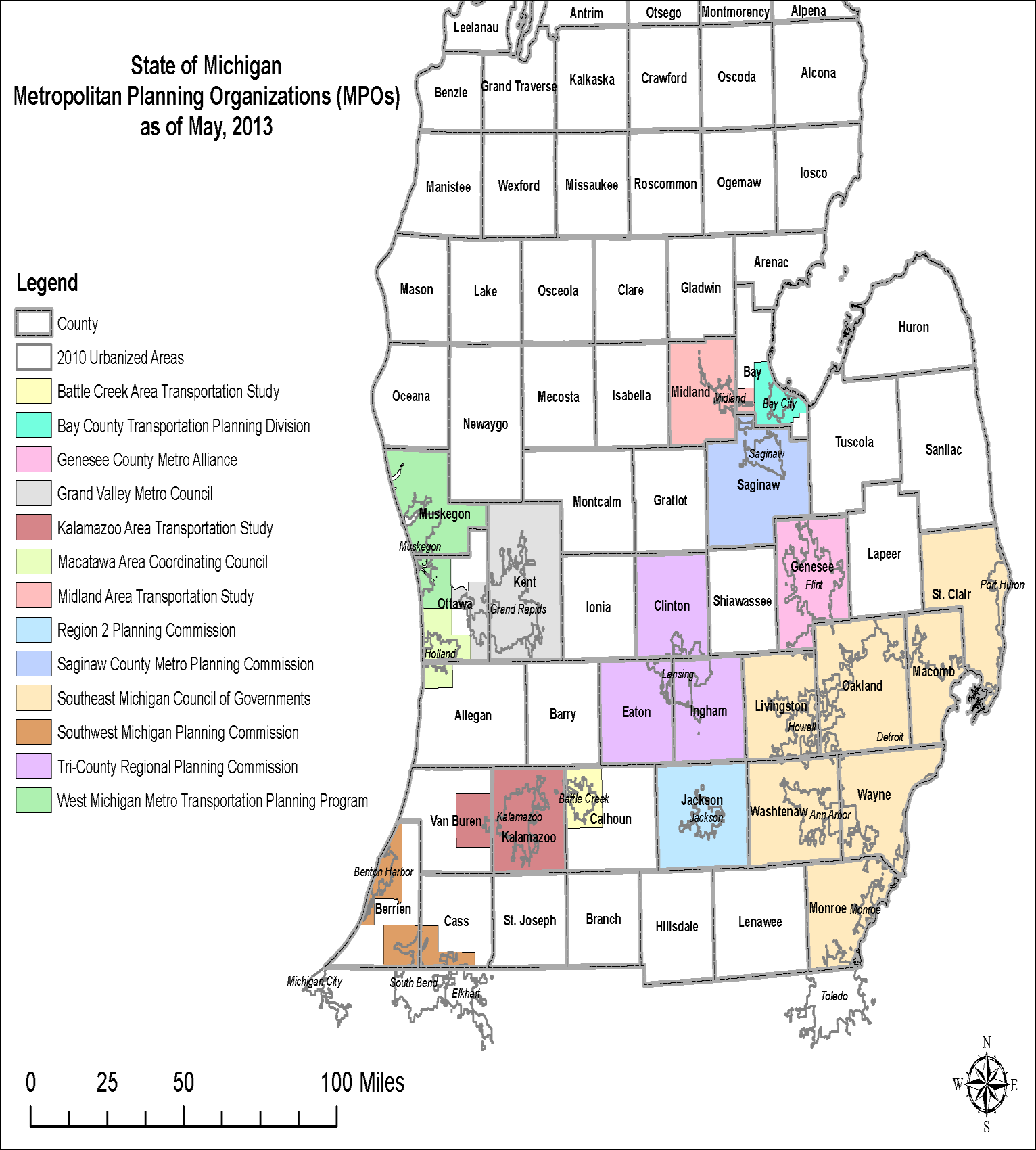
4 Collection Timeline Rating Teams Required Tools Corrections for the Framework Map Reimbursement Working with Smaller Cities and Villages DATA COLLECTION CYCLE Step 1: Identify your TAMC network for data collection Step 2: Export TAMC network for use with the LDC Step 3: Send a copy of TAMC network to the CSS Step 4: Import the network into the Laptop Data Collector (LDC) Step 5: Connect the GPS to your laptop and begin collecting data Step 6: Export collected data from the LDC Step 1: Identify your local (or non-federal-aid) network for data collection Step 2: Export local (or non-federal-aid) network for use with the LDC Step 3: Import the network into the Laptop Data Collector (LDC) Step 4: Connect the GPS to your laptop and begin collecting data Step 5: Export collected data from the LDC Step 7: Import the collected data to Roadsoft Step 8: Export Roadsoft asset management data for the regional Roadsoft database Step 9: Import Roadsoft asset management data from the local agency into the regional version of Roadsoft Step 10: Export shape file and submit to TAMC PASER Data Quality Control Guide Appendix A PASER Michigan-Specific Cheat Sheet Appendix B Michigan s Regional Planning Organizations Appendix C Michigan s Metropolitan Planning Organizations Appendix D New Midland Area Transportation Study (MATS) Boundary Appendix E PASER Certification/Training Requirement Policy ii
5 Appendix F Policy for Collection on Roadway Condition Data on (Paved) Non-federal-Aid Eligible Roads and Streets Appendix G Framework Correction Form Appendix H Data Collection Timesheet Index iii
6 iv
7 The Pavement Surface Evaluation and Rating (PASER) system is a visual survey method for evaluating the condition of roads. The method was developed by the University of Wisconsin Transportation Information Center to provide a simple, efficient, and consistent method for evaluating road condition. Michigan s Transportation Asset Management Council (TAMC) has adopted the PASER system for measuring statewide pavement conditions in Michigan. This manual describes the requirements and processes involved in collecting PASER data for TAMC in conjunction with the RPO/MPOs. It also includes information on how to split segments, rate sealcoats, and double-check collected PASER in Roadsoft. Part of TAMC s mission is to obtain accurate PASER that provides a clear view of the condition of the road network in Michigan. TAMC uses these ratings to communicate the condition of Michigan roads to the Michigan Legislature. At the local level, this data serves as the foundation upon which to build cost-effective pavement maintenance strategies. TAMC chose Roadsoft a roadway management system for collecting, storing and analyzing data for use in developing its statewide pavement rating collection strategy. Roadsoft is funded through the Michigan Department of Transportation (MDOT) and developed, supported, and distributed by Michigan Technological University s Center for Technology & Training (CTT). TAMC also works in conjunction with Michigan s Regional/Metropolitan Planning Organizations (RPO/MPO) to collect PASER data. Although these regional organizations operate under many different names and serve a variety of different areas, they all participate in coordinating and performing PASER data collection. v
8 vi
9 1
10 2
11 According to Act 51 (P.A , P.A ) each local road agency shall annually report the mileage and condition of the road and bridge system under their jurisdiction to TAMC. To fulfill the requirement of this Act each year TAMC sets requirements for road condition data collection and submission by road-owning agencies in Michigan. Road condition rating is eligible for reimbursement from TAMC if the required training is attended and proper documentation is submitted at the end of the collection process (see Data Collection Procedures section for details). Paved Roads: At least 50% of Federal-aid eligible, paved roads must be rated each year. Each rated roads with a paved surface requires three categories of data: 1. Surface Type 2. PASER number 3. Number of Lanes Unpaved roads: Unpaved road inventory should be collected for unpaved roads in the Federalaid-eligible system; these roads only require surface type data. Collection teams will collect all information on unpaved road types (unpaved roads with an unimproved earth surface or with a gravel surface can be classified at the local agency s discretion) within their network (50% of the Federal-aid eligible) for collection each year. Based on current estimates, unpaved roads is approximately 4% of the Federal-aid system. According to Title 23 of the United States Code 1, Federal-aid eligible roads are highways on the Federal-aid highway systems and all other public roads not classified as local roads or rural minor collectors. This definition can be stated in terms of National Functional Classification (NFC), where the NFC is 1, 2, 3, 4, 5 for rural/urban or 6 for urban only where one or both sides of the road on or in an urban boundary (RU_L > 1 or RU_R > 1). NFC codes are defined as: 1 Interstates 5 Major Collectors 2 Other Freeways 6 Minor Collectors 3 Other Principal Arterials 7 - Local 4 Minor Arterials 0 or uncoded not a certified public road RU_L 1 Rural/Urban designation left RU_R 1 Rural/Urban designation right 1 Rural area 3 Small urbanized area (50,000 to 199,999) 2 Small urban area (5,000 to 49,999) 4 Large urbanized area (200,000 or more) 1 Subchapter E, 23 U.S.C (2003) 3
12 For paved Federal-aid data collection, the council collects PASER data based on the above definition of Federal-aid eligible so you will not be collecting PASER data on Rural Minor Collectors. Using the Roadsoft query of Federal Aid = True will take this change into account and give you the correct network conforming to the current definition. The three main PASER manuals used by Michigan are for asphalt, concrete, and sealcoat pavements. The PASER manual for brick is also used as brick is reported, but it is not widely needed. These can be found at or Hot mix asphalt is a pavement type with the top structural layer being HMA. Generally, a structural hot mix asphalt layer has a thickness of 1.5 or more. Composite pavements should be rated with the asphalt rating system, but be inventoried as a composite pavement. A composite pavement is an old concrete pavement that has an asphalt overlay. A chip seal or a sealcoat on top of an asphalt pavement should also be rated with the asphalt rating system. This type of pavement is not considered a sealcoat pavement because the asphalt below is considered the structural layer. A concrete pavement is a pavement composed of riding surface of concrete. This pavement should be rated using the rating system outlined in the Concrete PASER Manual. A sealcoat pavement is an unpaved road with a sealcoat (chip seal) surface treatment. There is no full-width structural layer of asphalt in a sealcoat pavement. This pavement should be rated with the modified Michigan sealcoat rating system, which uses a 1-10 scale. The rating scale in the Brick & Block PASER manual is To be consistent with other pavement rating scales, the brick and block scale must be doubled resulting in 2, 4, 6, and 8 as 4
13 ratings while maintaining the original definitions from the manual. A rating of 10 is reserved for brick and block pavements that are in like new condition and less than one year old. The PASER system was created for use in Wisconsin and not for the Michigan TAMC. When using the PASER system in Michigan, data collectors need to be aware of a few changes. These changes provide simplified and uniform data collection and increases reporting accuracy to the Michigan Legislature. Each rating in the PASER Manuals includes written descriptors (Excellent, Very Good, Good, Failed, etc.) that are part of the rating category name and give an overall impression of the state of each rating. These descriptors are as follows for asphalt and concrete pavements: Rating PASER TAMC 10 & 9 Excellent Good 8 Very Good 7 & 6 Good Fair 5 Fair 4 Fair 3 Poor 2 Very Poor 1 Failed Poor The PASER manual descriptors are not based on any formal definition relating to the quality of the pavement and they should not be confused with the formal definitions of Good, Fair and Poor that TAMC has developed and uses for reporting. TAMC groups the 1-10 rating scale into three categories (Good 8-10, Fair 5-7, Poor 1-4) based upon a definition that relates to the type of work that is typically required for each rating grouping (Routine Maintenance, Capital Preventive Maintenance, and Structural Improvement). Routine maintenance is the day-to-day, regularly-scheduled activities to prevent water from seeping into the surface. These activities include street sweeping, drainage clearing, gravel shoulder grading, and sealing cracks. PASER 8, 9, and 10 are included in this category. This category also includes roads that are newly constructed or recently seal coated. They require little or no maintenance. In TAMC nomenclature, these roads are considered Good. 5
14 Capital preventive maintenance (CPM) is a planned set of cost effective treatments to an existing roadway that slows further deterioration and maintains or improves the functional condition of the system without significantly increasing the structural capacity. The purpose of CPM fixes is to protect the pavement structure, slow the rate of deterioration, and/or correct pavement surface deficiencies. PASER 5, 6, and 7 are included in this category. Roads in this category still show good structural support but the surface is starting to deteriorate. CPM is intended to address pavement problems before the structural integrity of the pavement has been severely impacted. These roads are considered Fair. Structural improvement is necessary when roads require structural improvement such as resurfacing or major reconstruction. Alligator cracking is evident. Rutting is beginning to take place; road rutting is evidence that the underlying structure is beginning to fail and it must be either rehabilitated with a fix like a crush and shape or totally reconstructed. PASER of 1, 2, 3, or 4 are included in this category. According to TAMC, these roads are Poor. The PASER system rates a sealcoat road (sealcoat over a gravel base) on a scale of 1 to 5; however, TAMC modifies this rating system to a 1 to 10 scale. Thus, all surface types in the paved road network are rated on the same, standardized rating scale. In Michigan, the sealcoat scale is based on the relative percent of distress observed in the pavement. Using a Percentage Approach The Michigan sealcoat scale assesses the percentage of distress over a cross section of the total length of the segment under consideration. The observed distresses are: Edge distress Lane distress (including rutting) Raveling Rutting These percentages are not cumulative. If none of the observed surface distress percentages exceeds the upper limit of a rating description outlined in the sealcoat rating chart, then that description rating is your selection. For example, consider a cross section of the roadway segment; it can be 50 ft. long or 1 mile long. A sealcoat with a rating of 5 allows up to 20% raveling, 20% edge distress, or 20% lane distress. If your assessment yields 10% raveling, 5% edge distress and 20% lane distress, the rating is 5 because none of the distresses exceeds 20%. It is not a rating of 6 because the 20% lane distress exceeds the 10% criteria, and it is not a rating of 4 because edge distress and lane distress percentages do not exceed the 20% limit for 5. Cumulative total distress is irrelevant for this rating system. 6
15 Consult the table Michigan Sealcoat Rating Guide Table on the following page for specific rating criteria. 7
16 Michigan Sealcoat Rating Guide Table Rating Description Condition / defects Remedy / action Typical age in years * 10 Excellent New construction None < 1 year 9 Excellent Like new None 1 to 3 8 Very good First signs of distress Limited edge distress Routine maintenance Minor edge seal 3 to 5 7 Good Minor distress Edge distress with limited lane distress <5% Raveling < 5% Minor asphalt or spray-injection patching Possible single application sealcoat 4 to 6 6 Good Moderate distress Edge distress up to 10% Lane distress up to 10% Raveling up to 10% Moderate asphalt or spray-injection patching Single application sealcoat 5 to 7 5 Fair Distressed Edge distress up to 20% Lane distress up to 20% Raveling up to 20% Moderate asphalt or spray-injection patching Single application sealcoat With up to 50% double application sealcoat 6 to 8 4 Fair Edge distress up to 30% Lane distress up to 30% Rutting of ½ to 1 Asphalt or spray-injection patching and double application sealcoat 7 to 9 3 Poor Edge distress up to 50% Lane distress up to 50% Rutting of 1 to 2 Wedge and /or asphalt or sprayinjection patching and double or triple application sealcoat May be necessary to crush and reshape prior to new sealcoat surface 8 to 10 2 Very poor Edge distress > 50% Lane distress > 50% Rutting greater than 2 Reconstruct by crush and shape prior to new sealcoat surface, possible return to gravel > 9 1 Failed Extensive distress > 50% of surface area Reconstruct by crush and shape prior to new sealcoat surface, or return to gravel >10 0 Not rated 8
17 Extent of Rutting In both the Asphalt PASER Manual and the Revised 2013 edition of the Asphalt PASER Manual, the extent of rutting for PASER 4 should be revised to ½ -1 and PASER of 3 should be revised to rutting of 1-2 for Michigan-specific data collection (see the table, Asphalt Road Rating Guide: Changes for Michigan-specific Assessment of the Extent of Rutting, below). Please note this in your PASER Manual and refer to the PASER Cheat Sheet (see Appendix A) for additional information. Asphalt Road Rating Guide: Changes for Michigan-specific Assessment of the Extent of Rutting Asphalt PASER Manual PASER 4 < ½ inch deep rutting Asphalt PASER Manual, Revised 2013 PASER 4 < ½ inch deep rutting PASER 3 ½ 2 deep rutting revise to revise to revise to Michigan-specific Asphalt Road Rating MI PASER 4 ½ 1 deep rutting Michigan-specific Asphalt Road Rating MI PASER 4 ½ 1 deep rutting MI PASER deep rutting Extent of Block Cracking Because the descriptor 50% of the surface is undefined for Michigan s data collection, both versions of the Asphalt PASER manual should be revised as follows: PASER 6 Initial block cracking (6-10 Blocks), PASER 5 Moderate block cracking (1-5 blocks), PASER 4 Severe block cracking (less than 1 blocks), and PASER 3 Severe block cracking (alligator) (see the table, Asphalt Road Rating Guide: Changes for Michigan-specific Assessment of the Extent of Block Cracking, below). Please note this in your Asphalt PASER Manual and refer to the PASER Cheat Sheet for additional information. 9
18 Asphalt Road Rating Guide: Changes for Michigan-specific Assessment of the Extent of Block Cracking Asphalt PASER Manual (both versions) PASER 6 PASER 5 Block cracking up to 50% of the surface PASER 4 Block cracking (over 50% of the surface) PASER 3 Severe block cracking revise to revise to revise to revise to Michigan-specific Asphalt Road Rating MI PASER 6 Initial block cracking (6-10 blocks) MI PASER 5 Moderate block cracking (1-5 blocks) MI PASER 4 Severe block cracking (less than 1 blocks) MI PASER 3 Severe block cracking (alligator) PASER 9 and Joint Rehabilitation In the Concrete PASER Manual on page 17, the bottom photograph includes the description RATING 9 Recent joint rehabilitation. Like new condition. This example should be crossed out or noted as an extremely unlikely situation due to the fact that, by the time a concrete pavement requires joint rehabilitation, the original concrete slabs are rarely in a like new condition (without any distresses). 10
19 Speed Rating roads at high speeds can cause inaccuracy. Reviews conducted by the CTT s PASER trainers have shown that teams that view roadways at lower speeds are much more likely to rate them accurately. Rating roads at high speeds can cause distresses to be missed and ratings to be higher than appropriate. Lighting Conditions Changes in lighting conditions and the time of day can influence how some distresses are perceived. Bright sunlight directly overhead may make surface texture defects or fine cracking hard to discern. Rating early in the morning or late in the afternoon on a sunny day while driving into the sun may also make it difficult to rate roads effectively. If lighting conditions are poor, slow down or stop to make sure that you are not overlooking any visual cues. Trees cause shadows that can appear to be road distresses. Tree shadows on the road make for very difficult rating conditions. Options are to return to the location at a different time or drive at lower speeds. Inclement Weather PASER is a visual assessment system. Trying to rate pavement in the rain is ineffective. Road surfaces look different when they are wet cracks look larger, puddles can hide distresses, and so forth. Teams should not rate roads when they are wet. Group Dynamics Teams need to be aware of group dynamics in their vehicles. Condition rating is supposed to be a group process. However, the process also needs to conform to PASER procedure. Teams should read the PASER descriptions closely and refer to the reference sheets for clarification. Road Ownership, Use or Importance Do not rate an important road less than the actual PASER. Do not confuse a management decision with rating. Road ownership, use or importance does not change its distress rating. 11
20 Road Construction Projects When rating a road currently under construction where the old pavement is gone, the road should be rated as if the construction were complete. Rate the existing pavement if construction limits are not established by road work (more than traffic control devices). Rate What You See Don t anticipate the next PASER number based on previous PASER data. Rate what you see. The value of the actual rating is a usable record of road improvements and ratings for managing costs and extending service life. Rate the Worst Lane If there is a difference in quality, select the worst lane for your rating. Rate Distress, Not Ride Quality Just because a road rides well does not mean that it has no distresses in need of capital preventative maintenance or structural improvement. This is especially true on a road with rutting and cracking in the wheel path, both of which can cause rapid deterioration. Conversely, an asphalt surface in relatively good condition with sealed longitudinal cracks often makes quite a bit of noise as tires pass over the expanded crack seal. More noise does not always mean severe distress. Do not let ride quality distort your ratings. Make Careful Distress Observations on Light-colored Pavement Oxidized pavements can be very light and often look gray or off-white, which causes distresses to be less visible. Flat lighting on an oxidized pavement can also hinder visibility of distresses. Measure Rutting It can be difficult to detect rutting when moving at high speeds on a sunny day. To help avoid incorrect rutting assessments, each regional office has a six-foot aluminum T-bar. By using this bar in conjunction with a tape measure, teams can quickly get a tangible assessment of the extent of rutting on a road where it is practical and safe to do so. It is the rating team s decision to choose whether to measure rutting by physical assessment. 12
21 Paved Shoulders For paved shoulders, rate the pavement from edge line to edge line and omit the shoulder condition. Shoulders are not rated because they are constructed differently than the traveled way; they typically have a thinner structural layer so deterioration is different. Boundary roads (roads that fall between jurisdictions) often have non-standard characteristics and splits on the Roadsoft map. As a result, it may be unclear which jurisdiction is responsible for rating a boundary road. To eliminate potential data collection issues when rating boundary roads, follow these two rules: Rule 1: Follow the Data Collection Procedures section carefully. The steps for collecting and submitting TAMC data are laid out in a specific order to prevent rated roads from being overwritten by unrated roads. If you deviate from the documented procedure, some of your rating data may be overwritten by unrated roads. Rule 2: Rating teams should rate all boundary roads in their data collection networks regardless of ownership or maintenance responsibilities. If a team encounters an undocumented change in the surface type or layout of a road (such as number of lanes), they should create a split in the Roadsoft map to reflect the change. Although the Roadsoft map initially splits all street and road segments on an intersection-to-intersection basis (node to node) or by using Act 51 boundaries (township/city/county), agencies can add road segment splits to denote changes in surface types or conditions. Rating teams should respect segment splits previously created within Roadsoft by local agencies. However, the following guidelines will help you decide if introducing new splits is warranted and will direct you in introducing new splits if necessary while collecting TAMC data. If the area in question has received rehabilitation or reconstruction separate from the framework segment from which it came, then the segment in question should be split from the framework segment into its own designated rating segment. Avoid splitting segments into lengths of less than ¼ mile. 13
22 Change in Surface Type If the road surface changes (e.g., from asphalt to gravel, asphalt to chip seal, chip seal to gravel), then splitting a segment to reflect a change in surface type can ensure that the inventory collected is representative of the actual road conditions. Number of Lanes Commercial or development activity may require the addition of through lanes or continuous left turn lanes within a given framework segment. Splitting a segment to reflect this addition will ensure that Roadsoft s lane mileage inventory reflects the true mileage. Intersection as a Unique Facility Many intersections within a county/city system are extensions of segments, meaning their design, surface type, service life, and number of lanes is no different than the segment they stem from. However, some intersections have significant changes in surface type and/or geometry. In these cases, it may be best to designate the intersection as a unique facility by making it a distinct segment. Environmental Factors Environmental factors can have a significant impact on a segment of road. For example, regular flooding or exceptional frost heave can cause severe damage to the roadway. Although this type of deterioration is rare, these segments should be designated as their own segment if they are longer than a ¼ of a mile. This helps to isolate the area needing rehabilitation or reconstruction. The following cases do not affect the network as a whole and, therefore, do not warrant segment splitting: Change in PASER over a short stretch (e.g., 50 feet) Short right or left turn bay School zone Traffic count segments 14
23 During data collection, you will be merging in and out of traffic, slowing down, pulling off to the shoulder for team discussions, and so forth; always take safety precautions! Driving the team vehicle is not something to be taken lightly. All the vehicles must be equipped with a warning light bar. Warning garments should be worn by raters that get out of the vehicle to view distress better or to measure rutting better. Above all, be sure to comply with your employer s warning garment and safety procedure requirements. The best configuration for a three-person team is the rater in the front passenger seat, and the data entry person in the back seat. If the data entry person sits in the front seat with a laptop, they could be injured by an airbag discharge and can be distracting to the driver. 15
24 16
25 17
26 The Michigan TAMC collects data for Michigan s Federal-aid road network. In addition, TAMC requests submission of PASER data collected with or without reimbursement for Michigan s paved non-federal-aid road system. Submitting data sets for these two networks gives TAMC a better understanding of Michigan road conditions. However, these two networks have different collection procedures broken down into Federal-aid procedures (Steps 1-6, coded blue in this manual) and Paved Non-Federal-Aid procedures (Steps 1-5, coded green in this manual) by which you are to collect data in the Laptop Data Collector for import into Roadsoft; during the data submission process (coded blue in this manual) both sets of collected data can then be imported together into Roadsoft (Step 7), exported into the regional version of Roadsoft (Steps 8 and 9), and submitted to TAMC (Step 10). Data collection begins: April 1 of every year Data collection completed by: Last Friday in November Data submitted to the Center for Shared Solutions (CSS) by: First Friday in December To schedule your Federal-aid PASER data collection, contact your RPO or MPO. See the maps in Appendix B, Appendix C, and Appendix D to determine your jurisdiction s planning office. See if you need contact information for an RPO or if you need contact information for an MPO. Federal-aid rating teams should be comprised of one member from MDOT, one member from the Act-51 jurisdiction s RPO/MPO, and one member from the jurisdiction being rated (County, City, or Village). Non-Federal-aid data collection only requires one trained person from the agency or their representative. Required training sessions Anyone who participates in the annual PASER data collection of the Federal-aid system and who influences the rating activity must attend on-site PASER training in the same year the data collection occurs. In addition to attending one on-site session, raters who did not attend PASER training the year prior must attend one supplemental PASER webinar session. 18
27 TAMC has instituted a testing and certification program for PASER data collectors who attended PASER training and collected PASER data for multiple years. The certification allows experienced raters to opt out of training in future years. The full certification/training requirement policy and a link to TAMC policy is attached as Appendix E for the Federal-aid system and as Appendix F for the paved, non-federal-aid road system. Quality control The RPO or MPO coordinating PASER collection must review the collected data before sending it to the CSS. This quality control procedure is described in detail in Step 10 of the datacollection submission process. Computer hardware Data collection teams receive a laptop computer and a GPS unit from their RPO/MPO. However, it is best to have a second laptop in the vehicle just in case something goes wrong. Many county road commissions and cities now have laptop computers; consider using a second laptop for backup. Computer software and data sets Before you begin collecting road data for the data collection season, ensure that you are using the newest versions and latest frameworks of Roadsoft and Laptop Data Collector, which are released by April 1 of the collection year. Visit for the newest version or for Roadsoft updates. If you have any questions or concerns, please call Roadsoft support at (906) The data collection process needs to start with the local agency s Roadsoft data set, not with a regional version of Roadsoft. Collection teams should therefore use local data not regional data as a starting point. Note that changes to data will only be sent to TAMC if they were collected in the LDC. Rating and changes in ratings should be initially entered in the LDC (not in Roadsoft) or data will not be reported. Replacement vehicles If you need another vehicle, either use one from the county road commission or rent one. If you need to rent a vehicle, the MDOT rater should sign the rental agreement and purchase the extra insurance. 19
28 If a team suspects that they have discovered a needed correction in their jurisdiction s map, they should first place a short notation in the LDC memo field for that segment (select the Inventory tab). Consistent use of a tag such as correction can simplify creating a Roadsoft report containing these errors and the road segments where they are located. This information can be passed on to the CSS for correction. Next, a team should fill out the Asset Management Change Request for Michigan Geographic Framework (see Appendix G) and submit it to: Joshua Ross Michigan Center for Shared Solutions Romney Building, 10th Floor 111 S. Capital Ave Lansing, MI You can also request changes by contacting Mr. Ross at (517) or rossj@michigan.gov. Data collection for federal aid is reimbursable for qualified individuals. Non-Federal-aid collection reimbursement can be given if previously approved by TAMC coordinator. Requests for prior approval to collect non-federal-aid data for reimbursement and invoices for rating efforts (see Appendix H) should be submitted through your RPO/ MPO to: Roger Belknap Michigan Department of Transportation PO Box W. Ottawa St. Lansing, MI Unpaved inventory collection on the non-federal-aid system will not be reimbursed. See current TAMC policies for current correction and reimbursement rules. Smaller cities and villages are often enthusiastic about the data collection process. However, it can be time consuming to visit smaller communities (i.e., communities that have 10 or 20 miles of Federal-aid eligible roads) in order to set up a Roadsoft network. If an agency has a limited number of miles in its jurisdiction, two options exist for including them in the data collection process. In the latest versions of Roadsoft and the LDC, data collection exports from the LDC can be provided to small agencies as a means for transferring recently collected PASER data that were collected using an export from the county version of Roadsoft. This option should only be used for small cities and villages with their permission because the historical road splits and historical 20
29 data present in the small local agencies Roadsoft database will not be available to assist in collection activities. Medium to large cities and villages should collect data using an export from the agency s version of Roadsoft as you would with a county. Another option for dealing with very small agencies is to provide them with a report (i.e., of the PASER for the physical reference segment) and have them manually enter data in their version of Roadsoft. Both of these options allow data collectors to use the collection networks that they build at their road commission without having to stop and upload data for these small agencies. Data collection should be dealt with on a case-by-case basis. This figure shows the data collection cycle for assessing a road network; the steps in this figure correspond to the steps outlined in this section of the manual. Keep in mind that saving a backup during Step 6, signified by the green arrow ( ) above, is crucial: this backup file creates a save point that allows recovery of data from a previous save point or reverting of data to a previous save point. Make a copy of the backup file you exported in Step 6 and save it outside of Roadsoft. This backup of Roadsoft data must be done prior to importing. 21
30 22
31 23
32 24
33 Make sure you are using the local agency s copy of Roadsoft at the road commission, city, or village for which you will be collecting data. The decision of how to develop a TAMC network is being left up to agencies and Regional Coordinators. Remember that networks must include at least 50% of Federal-aid eligible road networks. These would include all roads that were not collected in the previous year. In Roadsoft, create your TAMC network 2 for your current year (CYYY): i. Select the Road layer in the Map Layers window. ii. iii. iv. Select Filter Builder: a. Right-click anywhere on the map. Add a criterion Federal Aid = True: a. Select Federal Aid from the fields list. b. Select equals (=) as the Operator. c. Select True as the Value. d. Select the Add button. Add a criterion of TAMC Collection Year <> PYYY (where PYYY should be your previous year): a. Select TAMC Collection Year from the fields list. b. Select not equals (<>) as the Operator. c. Select PYYY as the Value. d. Select the Add button. v. Save this Road Layer Filter: a. Select the Save option at the top of the dialogue box. b. Give the filter a name such as CYYY TAMC Network. c. Select the Save button. This filter creates your new TAMC network. continued on next page 2 If you are collecting data for a paved non-federal-aid project, follow the steps in the Paved Non-federal-aid Data Collection section, which begins on page
34 vi. vii. Apply your new CYYY TAMC network as a selection: a. Select Replace Selection. The Selection Information: Road window will populate with selection data. Examine your CYYY TAMC network on the map: a. Visually verify the selected segments are appropriate for rating this year: you should be collecting data for all roads not rated in PYYY. A full Federal-aid collection consists of PYYY data and CYYY data. If you have any questions or issues creating your TAMC network for your current year, please refer to the Roadsoft Manual help documentation: Select_ Assets/Use_the_Filter_Builder/Use_the_Filter_Builder.htm. Or, please call Roadsoft technical support at (906)
35 NOTE: For this step, do not select Export for LDC from the LDC menu; this method will code your data for local use only and will not transmit your data to TAMC. In Roadsoft, export your TAMC network for use with the LDC: i. Open the Export to LDC dialogue box (see image below): a. Select the TAMC menu from the main menu options (Roadsoft menu bar). b. Select 1 - (County/City Does This) Export Data for LDC. This opens the Export to LDC dialogue box. ii. Locate the new TAMC network that you wish to export: a. Select Export Network in the Export to LDC window. b. Select the Select button that appears. c. Locate the TAMC network that you saved in Step 1: Type the name in the search field. OR: Scroll through the list until you locate your network. d. Select the network. e. Select the Ok button. continued on next page 27
36 iii. iv. Define an Export Path: The Export Path is the location on your hard drive where you want to save the export file. a. Select the folder icon ( button) to browse your hard drive for the location where you want the export to be saved. OR: Type/paste your desired path into the textbox. Save the export file to the location you specified: a. Select the Export button. b. Select the Ok button to close the window confirming a successful export. Roadsoft creates two files in the location you specified: - RStoLDC_[jurisdiction]_[date]_[time].ldcz - RStoLDC_[jurisdiction]_[date]_[time].zip v. Copy the.ldcz file to a CD, flash drive, or other portable storage device. You will be transferring the.ldcz onto the laptop that has the LDC installed on it. You will also be sending the.zip file to TAMC for the purposes of 50% network reporting. 28

37 CSS requests data before and after collection. Therefore, your agency should submit a copy of the exported TAMC network to the CSS before beginning data collection. i. Open your web browser (e.g. Microsoft Edge, Internet Explorer, Mozilla Firefox) and go to: ii. iii. iv. Select the Investment Reporting menu; then, select Data. Log in using your user ID and password. Select the Send sub-tab. v. Select the Other File button. vi. Select your jurisdiction from the dropdown menu. vii. Select Browse to attach the.zip file you created in Step 2. viii. ix. Select Upload to submit the data to TAMC. Finally, you must Update Status to notify TAMC you are complete. 29
38 In the LDC, import your TAMC network for data collection: i. Connect the portable storage device containing the export file to your laptop. The export file is the.ldcz file (not the.zip file) created in Step 2 by the local agency. ii. Complete the Roadsoft Laptop Data Collector v# Login dialogue box: a. Start the LDC. The Roadsoft Laptop Data Collector v# Login dialogue box (see image below) will open. b. Enter the Crew (name/names of the person/people rating). c. Select a DB (database) by selecting the folder icon ( button) to locate the export file on the portable storage device. If you want to change your database while inside the LDC, select the File option from the main menu and then select Change DB (Import Data from Roadsoft). d. Select the Ok button. This will import the network created in Step 1 into the LDC. 30
39 A. Connect the GPS: i. Open the LDC on the laptop. Complete the procedure below outside and free from buildings or other possible signal obstructions. ii. iii. iv. Make sure your GPS device is turned off; then, connect the GPS to your laptop using the serial or USB connection. If your GPS is on before connecting it, your mouse pointer may jump around erratically. If this happens, turn off your GPS, leave it connected, and restart your laptop. Turn on your GPS and wait for it to acquire a position (this could take a couple of minutes). Establish communication between the GPS and the LDC: a. Select the GPS option from the main menu in the LDC. b. Select Start/Stop GPS Connection. c. Wait a few minutes for the GPS and the LDC to locate your current position. The LDC s GIS map will snap to the GPS position. If your GPS fails to connect, wait several minutes and try to connect again. For additional assistance, please consult the Roadsoft Manual at: (LDC)/Getting_Started/Prepare_for_LDC_Data_Collection/Prepare_for_ LDC_Data_Collection.htm. Or, please contact Roadsoft technical support if the problem persists. NOTE: If you are on or near a road segment that is NOT part of the network that you imported into the LDC, the LDC will not snap to a segment on the map. Drive your vehicle toward a road that is part of the network so that the vehicle marker can snap to it. If this does not happen, restart the LDC or contact Roadsoft technical support. continued on next page 31
40 B. Collect data: i. Use the following shortcut keys to enter data into the LDC s Road window Rating tab: Ctrl + S Surface Type Ctrl + +/- Zoom In/Out Ctrl PASER Ctrl + Arrow keys Pan the GIS Map Shift + Ctrl Number of Lanes Ctrl + Space bar Hold/Release Segment Ctrl + Enter Submit (save) Data For a complete list of shortcut keys, select the Help menu and then select Shortcut Keys. IMPORTANT: While collecting data, back up every hour or as often as conveniently possible. From the main LDC menu, select the File menu and then select Backup Database to create a data save point. If data collection spans multiple days, export the data every day and save a copy of the data file with a naming scheme of LDCtoRS_[jurisdiction]_[date]_[time].ldc2rs (inserting appropriate identifiers in place of bracketed text) to a CD or flash drive. NOTE: The History tab provides a history of PASER for the current segment. Viewing past PASER data before rating a segment can influence the rating. To avoid possibly influencing the current rating based on past ratings, this grid will not be visible until you submit a rating for the segment. ii. iii. Verify that there are no unrated roads in your TAMC network: a. Select the File option from the main menu. b. Select Current DB Statistics. c. Verify that the Total Miles Not Yet Rated field displays 0. If the field is zero, you have completed the data collection process and may proceed to Step 6 on page 35. Otherwise, continue to step iii in this Collect data process. Rate any remaining unrated segments: a. Select the File option from the main menu. b. Select Check for Unrated Segments. The Unrated Segments dialogue box (see image right) will open. c. Highlight a row in the Unrated Segments dialogue box. This selects the corresponding segment on the map. 32
41 d. Enter a rating for the segment in the Road window. e. Repeat steps c and d until the list of unrated segments is completed. f. Use the Refresh button to update the form. When there are no more records in the grid, all segments have been rated and you may proceed to Step 6 on page 35. Teams must drive the non-paved roads segments on the federal-aid system and verify the pavement type on the road segment if they have not done this already. Road segments that have a surface type currently set as Undefined must be validated by changing the surface subtype to the appropriate subtype. Select the Validate Surface Type button to save the data. If the start- and end-point inventory data for the unpaved road segments are already current, teams can select each individual unpaved segment (which will be colored orange see E. Sucker Creek Rd., which extends to the right in the image above) in the LDC and can then select the Validate Surface Type button without having to drive the entire segment. 33
42 If the start- and end-point inventory data for unpaved road segments are already current and accurate, a tool to mass-validate these segments can be found in the File menu of the LDC. Select the File menu and choose Check for Unvalidated Non-Paved Segment from the dropdown menu. In the Unvalidated Non-Paved Segments dialogue box, place a checkmark in the checkboxes next to each segment that will be validated using this tool. After checking all or some segments, select Validate Checked Segments to submit an inventory validation for the checked segments. All orange segments that are checked with this tool should now be colored green on the map to indicate that they have been validated. NOTE: Only agencies that have accurate unpaved-road inventories for the federal-aid system should use this tool. 34
43 In the LDC, export your TAMC data collection for use in Roadsoft: i. Select the File option from the main menu in the LDC. ii. Select Export DB/Data to Roadsoft. The Export Data to Roadsoft window (see image below) will open. iii. iv. Save the export file on your hard drive: a. Enter a location on your hard drive in the Export Path field. OR: Select the folder icon ( button) to browse your hard drive and find a location. b. Select the Export button. c. Select the Ok button once the Export Complete notice displays. Copy the LDCtoRS_[jurisdiction]_[date]_[time].ldc2rs file to a portable storage device. VERY IMPORTANT: The LDCtoRS_[jurisdiction]_[date]_[time]. ldc2rs file functions as a data save point that can be useful for data recovery/reversion purposes. The Roadsoft team strongly recommends that you save a copy of the file in a permanent archive every day to facilitate data recovery. This file can also be used to update small cities and villages with limited Federal-aid miles. PROCEED TO COLLECTED DATA SUBMISSION PROCESS STEPS 7-10 (pages 51-61) if you are not collecting and submitting paved non-federal-aid data. Alternatively, proceed to the Non-Federal-Aid Data Collection section (Steps 1-5 on pages 39-48) if you are collecting and submitting paved non-federal aid data. 35
44 36
45 37
46 38
47 Non-Federal-aid data collection can be either reimbursable or non-reimbursable (see Reimbursement on page 20); the collection process is the same regardless of reimbursement. While agencies are not required to collect non-federal-aid data, agencies may find non-federalaid or local data to be useful for agency-specific needs or initiatives. Therefore, the process for developing a local collection network in Roadsoft is left up to the local agency s discretion. In Roadsoft, create your non-federal-aid network 3 : i. Select the Road layer in the Map Layers window. ii. iii. iv. Select Filter Builder: a. Right-click anywhere on the map. Add a criterion Federal Aid = False: a. Select Federal Aid from the fields list. b. Select equals (=) as the Operator. c. Select False as the Value. d. Select the Add button. Optional: Add any other criteria that you want to use in defining your network. v. Save this Road Layer Filter: a. Select the Save option at the top of the dialogue box. b. Give the filter a name such as CYYY Local Network or CYYY Non-Fed-Aid Network (where CYYY should be your current year). c. Select the Save button. This filter creates your new local (or non-federal-aid) network. vi. Apply your new CYYY Local (or Non-Fed-Aid) Network as a selection: a. Select Replace Selection. The Selection Information: Road window will be populated with selection data. continued on next page 3 If you are collecting data for a Federal-aid project for TAMC, use the steps for the Federal-aid Data Collection track, which begins on page
48 vii. Examine your CYYY Local (or Non-Fed-Aid) Network on the map: a. Visually verify the selected segments are appropriate for rating this year. If you have any questions or issues creating your local or non-federal-aid network for your current year, please refer to the Roadsoft Manual help documentation: Select_ Assets/Use_the_Filter_Builder/Use_the_Filter_Builder.htm. Or, please call Roadsoft technical support at (906)

49 There are two ways of exporting a local or non-federal-aid collection network from Roadsoft for use in the LDC. The first option is TAMC Export, which allows you to gather road rating and number of lanes; the second is Export for LDC, which allows recording of more data. Although both options can be used to collect road ratings, use the Export for LDC option when the collection requires more than road rating and number of lanes. Agencies should choose the process that best fits their needs. A. TAMC Export Option The TAMC Export Option, will automatically tag your data for TAMC. You can use this option for all non-federal aid collection. However, this option allows you to gather road rating and number of lanes data only. i. Open the Export to LDC dialogue box (see image below): a. Select the TAMC menu from the main menu in Roadsoft. b. Select 1 - (County/City Does This) Export Data for LDC. This opens the Export to LDC dialogue box. ii. Find the non-federal-aid network that you wish to export: a. Select Export Network in the Export to LDC window. Select the Select button that appears. continued on next page 41
50 b. Locate the non-federal-aid network you saved in Step 1: Type the name in the search field. OR: Scroll through the list until you locate your network. c. Select the network. d. Select the Ok button. iii. Define an Export Path: The Export Path is the location on your hard drive where you want to save the export file. a. Select the folder icon ( button) to browse your hard drive for the location where you want the export to be saved. OR: Type/paste our desired path into the textbox. iv. Save the export file to the location you specified: a. Select the Export button. b. Select the Ok button to close the window confirming a successful export. Roadsoft creates two files in the location you specified: RStoLDC_[jurisdiction]_[date]_[time].ldcz RStoLDC_[jurisdiction]_[date]_[time].zip v. Copy the.ldcz file to a CD, flash drive, or other portable storage device. You will be transferring the.ldcz file onto the laptop that has the LDC installed on it. B. Export for LDC Option 42 The Export for LDC Option does not automatically tag your data. This option is useful for collecting additional data like signs, guardrails, and culverts for local purposes. During this process, you will have an opportunity to opt for automatic tagging of your data for TAMC (see Step 2.B.i.c on page 43 and Step 7.iii on page 52). i. Open the Export to LDC dialogue box (see image below): continued on next page a. Select the LDC menu from the main menu in Roadsoft. b. Select Export for LDC. A message box will open asking Are you collecting Road Data for TAMC?
51 c. Confirm whether this data collection is for TAMC: Select the Yes button if this non-federal-aid data collection is specifically for TAMC; then, refer to Step 2.A.ii. The History tab provides a history of PASER for the current segment. Viewing past PASER data before rating a segment can influence the rating. To avoid possibly influencing the current rating based on past ratings, this grid will not be visible until you submit a rating for the segment. OR: Select the No button if this non-federal-aid data collection is specifically for local use; then, refer to Step 2.B.ii. Note that local-use data can still be sent to TAMC (Step 7.iii s Note on page 52). Selecting the No button will allow you to edit all road inventory data and to view historical ratings prior to entering a rating. The Export to LDC dialogue box will open. ii. Select the Road checkbox in the Export to LDC dialogue box (see image below). The Load Saved Filter window will open. iii. Locate the non-federal-aid network that you wish to export: a. Locate the non-federal-aid network you saved in Step 1: Type the name in the search field. OR: Scroll through the list until you locate the network. continued on next page 43
52 b. Select the network. c. Select the Ok button. iv. Define an Export Path: The Export Path is the location on your hard drive where you want to save the export file. a. Select the folder icon ( button) to browse your hard drive for the location where you want the export to be saved. OR: Type/paste your desired path into the textbox. v. Save the export file to the location you specified: a. Select the Export button. b. Select the Ok button to close the window confirming a successful export. Roadsoft creates one file in the location you specified: RStoLDC_[jurisdiction]_[date]_[time].ldcz vi. Copy the.ldcz file to a CD, flash drive, or other portable storage device so you can transfer it onto the laptop that has the LDC installed on it. You will be transferring the.ldcz onto the laptop that has the LDC installed on it. 44
 created in Step 2 from the local agency. ii.")
53 In the LDC, import your non-federal-aid network for data collection: i. Connect your portable storage device containing the export file to your laptop. Insert the portable storage device that contains your export file the.ldcz file (not the.zip file) created in Step 2 from the local agency. ii. Complete the Roadsoft Laptop Data Collector v# Login dialogue box: a. Start the LDC. The Roadsoft Laptop Data Collector v# Login dialogue box (see image below) will open. b. Enter the Crew (name/names of the person/people rating). c. Select a DB (database) by selecting the folder icon ( button) to locate the export file on the portable storage device. d. Select the Ok button. This will import the network created in Step 1 into the LDC. NOTE: If you want to change your database while inside the LDC, select the File menu and then select Change DB (Import Data from Roadsoft). 45
54 A. Connect the GPS: i. Open the LDC on the laptop. Complete the procedure below outside and free from buildings or other possible signal obstructions. ii. iii. iv. Make sure your GPS device is turned off; then, connect the GPS to your laptop using the serial or USB connection. If your GPS is on before connecting it, your mouse pointer may jump around erratically. If this happens, turn off your GPS, leave it connected, and restart your laptop. Turn on your GPS and wait for it to acquire a position (this could take a couple of minutes). Establish communication between the GPS and the LDC: a. Select GPS option from the main menu in the LDC. b. Select Start/Stop GPS Connection. c. Wait a few minutes for the GPS and the LDC to locate your current position. The LDC s GIS map will snap to the GPS position. If your GPS fails to connect, wait several minutes and try to connect again. For additional assistance, please consult the Roadsoft Manual at: (LDC)/Getting_Started/Prepare_for_LDC_Data_Collection/Prepare_for_ LDC_Data_Collection.htm. Or, please contact Roadsoft technical support if the problem persists. NOTE: If you are not on or near a road segment that is part of the network that you imported into the LDC, the LDC will not snap to a segment on the map. Drive your vehicle toward a road that is part of the network so that the vehicle marker can snap to it. If this does not happen, restart the LDC or contact Roadsoft technical support. continued on next page 46
55 B. Collect data: i. Use the following shortcut keys to enter data into the LDC s Road window Rating tab: Ctrl + S Surface Type Ctrl + +/- Zoom In/Out Ctrl PASER Ctrl + Arrow keys Pan the GIS Map Shift + Ctrl Number of Lanes Ctrl + Space bar Hold/Release Segment Ctrl + Enter Submit (save) Data For a complete list of shortcut keys, select the Help menu and then select Shortcut Keys. IMPORTANT: While collecting data, back up every hour or as often as conveniently possible. From the main LDC menu, select the File menu and then select Backup Database to create a data save point. If data collection spans multiple days, export the data every day and save a copy of the data file with a naming scheme of LDCtoRS_[jurisdiction]_[date]_[time].ldc2rs (inserting appropriate identifiers in place of bracketed text) to a CD or flash drive. ii. iv. Verify that there are no unrated roads in your local (or non-federal-aid) network: a. Select the File option from the main menu. b. Select Current DB Statistics. c. Verify that the Total Miles Not Yet Rated field displays 0. If the field is zero, you have completed the data collection process and may proceed to Step 5. Otherwise, continue to step c in this Collect data process. Rate any remaining unrated segments: a. Select the File option from the main menu. b. Select Check for Unrated Segments. The Unrated Segments dialogue box (see image below) will open. c. Highlight a row in the Unrated Segments dialogue box. This selects the corresponding segment on the map. d. Enter a rating for the segment in the Road window. e. Repeat steps c and d until the list of unrated segments is complete. f. Use the Refresh button to update the form. When there are no more records in the grid, all segments have been rated and you may proceed to Step 5. 47
 will open. iii. iv. Save the export file on your hard drive: a. Enter a location on your hard drive in the Export Path field.")
56 In the LDC, export your data collection for use in Roadsoft: i. Select the File option from the main menu in the LDC. ii. Select Export DB/Data to Roadsoft. The Export Data to Roadsoft window (see image below) will open. iii. iv. Save the export file on your hard drive: a. Enter a location on your hard drive in the Export Path field. OR: Select the folder icon ( button) to browse your hard drive and find a location. b. Select the Export button. c. Select the Ok button once the Export Complete notice displays. Copy the LDCtoRS_[jurisdiction]_[date]_[time].ldc2rs file to a portable storage device. VERY IMPORTANT: The LDCtoRS_[jurisdiction]_[date]_[time]. ldc2rs file functions as a save point that can be useful for data recovery/reversion purposes. The Roadsoft team strongly recommends that you save a copy of the file in a permanent archive every day to facilitate data recovery. PROCEED TO COLLECTED DATA SUBMISSION PROCESS STEPS 7-10 (pages 51-61) if you are not collecting and submitting paved Federal-aid data. Alternatively, proceed to the Federal-aid Data Collection section (Steps 1-6 on pages 25-36) pages if you are collecting and submitting paved Federal-aid data. 48
57 49
58 50

59 IMPORTANT: Before you import new data into Roadsoft, create a data save point for your existing Roadsoft database. To do so, select the Tools menu and then select Backup Roadsoft Database from the dropdown menu. Select a location where you would like to save your file using the file folder icon at the end of the Backup File field to set the location; select the Ok button. Then, select Create Backup. i. Open the Import Data From LDC dialogue box (see image below): a. Select the TAMC menu from the main menu in Roadsoft. b. Select 2 - (County/City Does This) Import TAMC PASER Data from LDC. The Import Data From LDC dialogue box will open. ii. Import your LDC data: a. Select the Browse for LDC Export button. b. Locate the LDCtoRS_[jurisdiction]_[date]_[time].ldc2rs file. c. Select Import LDC Data. The Import LDC Data dialogue box (see image below) will open. continued on next page 51
60 IMPORTANT: If the network being imported was created using the Export for LDC process and you selected the No button in the TAMC road data message box (see pages 42-43), two windows come up to clarify whether the included data is to be submitted to TAMC: the Submit PASER Data to TAMC? window and the TAMC PASER Rating Requirements window. iii. The Submit PASER Data to TAMC? window (see top image below) requires Yes/No verification: This window should not appear for Federal-aid submission; if it does, the Federalaid network was set up incorrectly and was not created as a TAMC Export. a. Select the Yes button if you plan to submit the data to TAMC. b. Select the No button if you do not want the data included in the TAMC submission in Step 8. iv. The TAMC PASER Rating Requirements window (see bottom image below) will open if the Yes button was selected. a. Select the Yes or No button as appropriate to reflect whether the data meets non- Federal-aid road PASER data collection requirements; This will determine whether the data will be included in the TAMC submission in Step 8. continued on next page 52
61 v. Back up your LDC data prior to importing: a. Select the Yes button in the Import LDC Data dialogue box to open the Roadsoft Database Manager and create a backup; proceed with importing your collected data. OR: Select the No button to skip the backup and continue with the import. Roadsoft will automatically restart when the import process is complete. 53
 to browse your hard drive for the location where you want the export to be saved.")
62 i. Open the Export TAMC Data to Region dialogue box (see image below): a. Select the TAMC menu from the main menu in Roadsoft. b. Select 3 - (County/City Does This) Export TAMC PASER Data to Region. The Export TAMC Data to Region dialogue box will open. ii. iii. iv. Define an Export Path: The Export Path is the location on your hard drive where you want to save the export file. a. Select the folder icon ( button) to browse your hard drive for the location where you want the export to be saved. OR: Type/paste your desired export path into the textbox. b. Select the Export button. Confirm the successfully completed export: a. Select the Ok button when the export confirmation dialogue box opens. Roadsoft will create a file named TAMC_[jurisdiction]_[date]_[time].tamz in the location you specified. Copy this.tamz file to a portable storage device. This.tamz file will be sent to your region for import into their Roadsoft database. 54

63 NOTE: This step is not performed in the field; it should be performed at the regional office to import inspection data from individual agencies. IMPORTANT: Before you import new data into Roadsoft, back up your existing Roadsoft database. To do so, open the Tools menu and then select Backup Roadsoft Database from the dropdown; select Create Backup. Select a location where you would like to save your file using the file folder icon at the end of the Backup File field to set the location; select the Ok button. Then, select Create Backup. i. Open the Import TAMC Data From Local Jurisdiction dialogue box (see image below) in the regional Roadsoft database: a. Select the TAMC menu. b. Select 4 - (Region Does This) Import TAMC PASER from County/City. The Import TAMC Data From Local Jurisdiction dialogue box will open. ii. Find the local agency s Roadsoft data collection that you wish to import: a. Select the Browse For LDC Export button b. Locate the TAMC_[jurisdiction]_[date]_[time].tamz file. c. Select the Import LDC Data button. An import dialogue box will open. continued on next page 55
64 iii. Back up your Roadsoft data prior to importing: a. Select the Yes button in the import dialogue box to open the Roadsoft Database Manager and create a backup; proceed with importing the collected data. OR: Select the No button to skip the backup and continue with the import. Roadsoft will automatically restart when the import is complete. NOTE: The Import Roadsoft Data screen lists the last four folders that you imported from. If this is the first time you are importing data, the screen will appear blank. 56
. ii. Open the Export TAMC ShapeFile Data for Council dialogue box (see image below): a.")
65 NOTE: Once your regional data are complete, export the regional shape file to the CSS. i. Verify your regional data before proceeding: a. Follow the steps in PASER Data Quality Control Guide (next page). ii. Open the Export TAMC ShapeFile Data for Council dialogue box (see image below): a. Select the TAMC menu from the main menu in Roadsoft. b. Select 5 - (Region Does This) Export TAMC Shape File to Council (Individual County Files). The Export TAMC ShapeFile Data for Council dialogue box (see image below) will open. NOTE: Do not use the standard Roadsoft shapefile export procedure [File > Export layer to File (Shapefile)] as it is different than TAMC export. iii. Define your export variables in the Export TAMC ShapeFile Data for Council dialogue box: a. Select the county you wish to export using the dropdown menu in the County tab. b. Define your Export Path: Select the folder button the right of the Export Path field to browse your hard drive for the location where you want the export to be saved. continued on next page 57
66 c. Select the Export button. This will export the data to the specified export path. The filename that is created will contain the county and year of data (e.g. AlconaCYYY.zip, where CYYY should be your current collection year). iv. Upload the exported file to TAMC through the CSS Investment Reporting Tool (IRT): a. Repeat Step 3 from the Federal-aid Data Collection on page 29; however, you must choose the PASER button rather than Other File in Step 3v. 58
67 It is important to ensure that your PASER data are accurate and comprehensive. It is easiest to check for errors in data at the local and regional levels before submitting data to TAMC. Data quality control can be performed by entering a series of queries into the Filter Builder in Roadsoft. The following steps will guide you through this process and ensure that your agency has a complete set of PASER data. NOTE: Changes to data will only be sent to TAMC if they were collected in the LDC or hand-entered in the region version of Roadsoft. Rating and changes in ratings should be initially entered in the LDC (not in Roadsoft) or data will not be reported. Data entered into Roadsoft (rather than being collected in the field) will result in missing data when the final collection file is sent to TAMC. Step 1: Determine the total length of your network i. Open the Filter Builder either by clicking with your right mouse button on the map in the Map window and selecting Filter Builder, or by selecting the map toolbar s Filter button and selecting Filter Builder. ii. iii. iv. In the Filter Builder window, select Open to open the Load Saved Filter window. Select your saved TAMC network for the current collection year and select the Ok button. Look at the bottom left of the Filter Builder window (see image below) and record the number of total Miles. You will use this number, along with additional criteria, to verify that your regional PASER data are correct. continued on next page 59
68 Step 2: Determine the total length of paved segments in your network i. Open the Filter Builder either by clicking with your right mouse button on the map in the Map window and selecting Filter Builder, or by selecting the map toolbar s Filter button and selecting Filter Builder. ii. iii. iv. In the Filter Builder window, select the Open button to open the Load Saved Filter window. Select your saved TAMC network for the current collection year and select the Ok button. Add Criteria of Surface Type = Asphalt, Concrete, Seal Coat, Brick and select the Add button. Look at the bottom left of the Filter Builder window. Record the number of Paved Miles. You will use this number, along with additional criteria, to verify that your regional PASER data are correct. Step 3: Verify that your agency s TAMC data are accurate Using the filter criteria provided in the Table of Quality Control Queries (next page), you will be able to detect missing or incorrect data by comparing the miles in a particular query against your original Miles (generated in Section 5, Step 1, above). In the Table of Quality Control Queries: Check: lists the potential error that the criteria checks for Criteria: lists the criteria that need to be entered into the network and Filter Builder Expected Output: lists the segments/mileage that should display at the bottom left of the Filter Builder after adding the criteria Troubleshooting: lists the most likely reason for not getting the expected outcome and steps to take to fix/obtain any inaccurate/missing data. continued on next page 60
69 Table of Quality Control Queries Ensure you have recorded the miles within your TAMC network (Section 5, Step 1, above) before you use the following table. When your miles are used in combination with these queries, these figures will help you verify the accuracy and completeness of the data you collected for TAMC. Check Criteria Expected Output Troubleshooting Check to see that all mileage in TAMC network have been rated TAMC Collection Year = current year Number of miles recorded in Step 1 There are segments that did not receive a rating. Missing rating data must be collected and entered in the LDC. Check to see if all submitted segments have a valid surface type TAMC Collection Year = current year Surface Type <> Undefined Number of miles recorded in Step 1 There are undefined roads in the network. Validate these segment types using the LDC. Check to see if all submitted paved segments have a valid surface rating TAMC Collection Year = current year Latest Surface Rating >= 1-Failed Number of miles recorded in Step 2 (Paved Miles) There are segments that have an invalid rating. These segments should be reviewed and rated in the LDC. Check to see if all submitted segments have a valid number of lanes TAMC Collection Year = current year Number of Lanes <= The highest number of lanes within your TAMC network Number of miles recorded in Step 1 There are segments that have an invalid number of lanes. Segments with invalid lanes should be reviewed and corrected in the LDC. *An unusually high number of lanes in the drop down list could signify an error in entry 61
70 62
71 63
72 64
73 65
74 66
75 67
76 68
77 69
78 This document is based on the policy adopted by The Transportation Asset Management Council on February 6, To view the policy go to Introduction: The Transportation Asset Management Council (TAMC) was established to expand the practice of asset management statewide to enhance the productivity of investing in Michigan s roads and bridges. Part of TAMC s mission is to collect physical inventory and condition data on all roads and bridges in Michigan. This document describes the policy and procedures for collecting the physical inventory and condition data on the Federal-aid eligible roads & streets of the State. Requirements: According to Act 51 (P.A , P.A ); each Local Road Agency and the Department of Transportation shall annually report to TAMC the mileage and condition of the road and bridge system under their jurisdiction. Rating Teams: Shall be comprised of one (1) member from the Michigan Department of Transportation (MDOT), one (1) member from the Regional / Metropolitan Planning Organization (RPO/MPO) and one (1) member from the Act-51 jurisdiction being rated (County, City/Village). Training: Anyone who participates in the annual PASER condition data collection of the Federalaid system and influences the rating activity MUST attend on site PASER training in the same year the data collection occurs. This does not discourage observers from riding in the data collection vehicles for information purposes. 70
79 New raters (never attended PASER training before) and seasoned raters (who did not attend PASER training the year prior) MUST attend one (1) supplemental PASER webinar training session in addition to attending one (1) on site session. Individuals that are PASER Certified Raters are exempted from on-site training as defined in PASER Certification Eligibility Requirements section of this policy. RPO and MPO coordinators are required to attend onsite training events every year regardless of their experience or certification status. RPO and MPO representatives are critical to the success of TAMC PASER data collection, so it is important for them to continue to promote and support the program by attending on site events. PASER Certification Eligibility Requirements To be considered a candidate to take the PASER certification exam the individual must meet the following criteria: 1) All candidates: Six (6) or more years (not including the current calendar year) of attendance of TAMC PASER on-site training as verified through the Center for Technology & Training (CTT) records. 2) Candidates that are civil engineers: five (5) or more years (not including the current calendar year) of attendance of TAMC PASER on-site training as verified through CTT records. 3) Rated a portion of their road network during TAMC collection for the same number of years trained (not including the current calendar year). This will be verified by a signed letter from the individual stating their rating experience. 4) Attend the current calendar year TAMC PASER on-site training portion of the workshop as well as the examination administration portion of the workshop. Certification Exam 1) The written certification exam will be administered at the on-site sessions of TAMC PASER training to eligible candidates. 2) Candidates must pass the written certification exam during the on-site training sessions. The passing score is 70% correct or will be adjusted using the normal distribution (bell curve) of the scores depending on the difficulty of the exam questions at the discretion of CTT staff. 3) Candidates who do not pass the certification exam will be able to attend another on-site PASER session during the same year and retake the exam as space and administration 71
80 allows. Individuals may repeat examination sessions as many times in one year as space and administration allows. 4) TAMC will hold exam results and exam questions as documents that are not open to the public without a freedom of information act request to prohibit development of files of exam questions that can be used to memorize facts rather than learning concepts. Certification Benefits and Responsibilities 1) Certified raters are required to attend on-site TAMC PASER training every other year; i.e. a two (2) year cycle to recertify by taking the certification exam. For example: a) Certification Year: Candidate is required to attend TAMC PASER on-site training portion of the workshop as well as the exam administration portion. If the candidate passes the certification exam he/she is certified for that and the next rating season. b) One year after Certification Year: The certified individual is not required to attend TAMC PASER on-site training portion of the workshop or the exam administration portion during the calendar year immediately proceeding the year of certification. Certified individuals must attend an organizational webinar. c) Two years after Certification Year: Recertification - the certified individual is required to attend TAMC PASER on-site training portion of the workshop as well as the exam administration portion to take the exam for recertification. As data is collected and Quality Assurance/Quality Control verifies that quality data is being produced, TAMC may consider decreasing the required training certification frequency to once every three (3) years for certified individuals. 2) Certified individuals are required to attend an organizational webinar for updates to business rules and changes to the data collection process. This webinar is required to keep certified raters informed of new guidance in the program and provides raters with an opportunity to interact with TAMC members. Data Collection: TAMC will annually budget for data collection on 50% of the Federal-aid network. Data collection must be consistent with the PASER collection business rules. The use of the Roadsoft Laptop Data Collector (LDC) is required. 72
81 The first day for field data collection shall be April 1st of every year. The last day for field data collection shall be the last Friday in November. Data Submission: The RPO/MPO Coordinator is responsible for submitting the completed PASER Data export to the Michigan Center for Shared Solutions (CSS). The deadline for the RPO/MPO to upload data to CSS is the first Friday in December. Data Standards: The export file from Roadsoft will be in a Shapefile format. It is the user's responsibility to ensure that the correct file type is submitted. Exports containing text files are not accepted. Instructions on how to prepare the Federal-aid road network for the LDC and how to submit the collected data can be downloaded at the following web site: *See the current year s PASER Training Manual under the PASER Training page at Quality Control: The Regional/Metropolitan Planning Coordinator MUST review the collected data before sending it to the Center for Shared Solutions (CSS) looking for missing entries (zeros), valid surface type, missing surface type, valid number of lanes, missing lane information and large jumps in PASER (up/down) in areas where treatments were not done. Reimbursement: Each rating team must complete a Time Expense Log in order to be reimbursed by TAMC. These are provided and submitted by the Regional / Metropolitan Planning Organization Coordinator to TAMC Asset Management Coordinator. The team member representing the Act-51 jurisdiction being rated (County, City/Village) will be reimbursed for relevant expenses related to the data collection effort (time, travel, meals) via annual RPO/MPO project authorization with TAMC. The team member representing MDOT will be reimbursed by TAMC via annual approved budget for PASER review. The team member representing the RPO/MPO will be reimbursed via annual project authorization with TAMC. 73
82 If you have any questions relating to reimbursement and/or this policy as a whole, please contact: Roger Belknap TAMC Asset Management Coordinator Michigan Department of Transportation P.O. Box W. Ottawa St. Lansing, MI (517)
83 75
84 76
85 This form can be found at: 77

86 This form is an example; please obtain appropriate Time Expense logs from your RPO/MPO. 78
Transportation Asset Management Program 2009 Federal Aid PASER Road Survey. August 2009
 Transportation Asset Management Program 2009 Federal Aid PASER Road Survey August 2009 WEST MICHIGAN SHORELINE REGIONAL DEVELOPMENT COMMISSION (WMSRDC) The WMSRDC is a regional council of governments representing
TAMS 2.1 User s Manual. Utah LTAP Center. Contact: Utah LTAP 4111 Old Main Hill Logan, UT. 84322-4111 800-822-8878 www.utahltap.
 TAMS 2.1 User s Manual Utah LTAP Center Contact: Utah LTAP 4111 Old Main Hill Logan, UT. 84322-4111 800-822-8878 www.utahltap.org Table of Contents Introduction 1 Initializing the program... 1 Data Needed
Pavement Management System Overview
 TABLE OF CONTENTS The Home Screen... 3 The Gutter... 4 Icons... 4 Quick Links... 5 Miscellaneous... 6 PMS Menus... 7 Setup Menu... 7 Construction Setup... 7 1. Material Codes... 8 2. Standard Sections...
The State of Michigan Transportation Asset Management Council 2005 PASER Survey Of Genesee County
 The State of Michigan Transportation Asset Management Council 2005 PASER Survey Of Genesee County Prepared by the Genesee County Metropolitan Planning Commission Staff The State of Michigan Transportation
City of Alpena Transportation Asset Management Program FY 2013 PASER Road Survey
 City of Alpena Transportation Asset Management Program FY PASER Road Survey Project overview: On August 20,, Northeast Michigan Council Of Governments Region 9 staff along with representatives of the City
Oscoda County Transportation Asset Management Program FY 2013 PASER Road Survey
 Oscoda County Transportation Asset Management Program FY PASER Road Survey Project Overview: On August 5,, Northeast Michigan Council Of Governments Region 9 staff along with representatives of the Oscoda
The State of Michigan Transportation Asset Management Council 2005 PASER Survey Of Shiawassee County
 The State of Michigan Transportation Asset Management Council 2005 PASER Survey Of Shiawassee County Prepared by the Genesee County Metropolitan Planning Commission Staff 1 The State of Michigan Transportation
Types of Data. Features. Getting Started. Integrated Roadway Asset Management System
 3-2014 GIS-based Asset Management System Optimize Maintenance Manage Signs Analyze Safety Roadsoft is a roadway management system for collecting, storing, and analyzing data associated with transportation
CHAPTER 2 PAVEMENT MANAGEMENT SYSTEM
 CHAPTER 2 PAVEMENT MANAGEMENT SYSTEM 2.1. INTRODUCTION TO PAVEMENT MANAGEMENT The ability of a pavement system to serve a society is largely a function of planning. Planning is the intersection between
Automated Inventory System
 Automated Inventory System User Manual Developed by USDA Food and Nutrition Service June 2009 (Incomplete) Table of Contents Welcome Menu Client Services Report System Inventory System Operations Tailgate
Local Pavement Asset Management Plan for the Village of Decatur
 2014 Local Pavement Asset Management Plan for the Village of Decatur 4/14/14 Table of Contents Summary of Assets and Goals of the Plan 3 Community Finances...4 Managing Lifecycles of Pavement Assets.7
Windows XP Pro: Basics 1
 NORTHWEST MISSOURI STATE UNIVERSITY ONLINE USER S GUIDE 2004 Windows XP Pro: Basics 1 Getting on the Northwest Network Getting on the Northwest network is easy with a university-provided PC, which has
Using an Edline Gradebook. EGP Teacher Guide
 Using an Edline Gradebook EGP Teacher Guide Table of Contents Introduction...3 Setup...3 Get the Gradebook Web Plugin... 3 Using Your Web Gradebook... 4 Using the Web Gradebook on a Shared Computer...
Patrol Master Software
 Handheld Guard Tracking System PATROL Patrol Master Software Software version : 3.1.16 Document version: Rev. C Contents 1. Introduction... 3 1.1 Purpose and main features... 3 1.2. Requirements... 3 1.3.
Hot Spot (Unsecured) Wireless Access Initial Setup and Login for MCC_HOTSPOT
 Wireless Access Initial Setup and Login for MCC_HOTSPOT") CLIENT INSTRUCTIONS PRIMARY KNOWLEDGE AREA Hot Spot (Unsecured) Wireless Access Initial Setup and Login for MCC_HOTSPOT Wireless Windows XP service pack 2 Purpose: Wireless Initial Setup sets the parameters
CLIENT INSTRUCTIONS PRIMARY KNOWLEDGE AREA Hot Spot (Unsecured) Wireless Access Initial Setup and Login for MCC_HOTSPOT Wireless Windows XP service pack 2 Purpose: Wireless Initial Setup sets the parameters
Colorado Off-System Bridge Program Description and Guidelines for Selecting Bridges for Rehabilitation or Replacement Funding
 C Colorado Off-System Bridge Program Description and Guidelines for Selecting Bridges for Rehabilitation or Replacement Funding These guidelines are intended to provide assistance in selecting OFF-SYSTEM
SECTION III-06 Surfacing Page 1 Revised 3/2/10. See the DESIGN GUIDELINES in Section I-06 for requirements for cross slope of the roadway.
 Page 1 Revised 3/2/10 See the DESIGN GUIDELINES in Section I-06 for requirements for cross slope of the roadway. For New/Reconstruction projects: The cross slope of the driving lanes range from 1.5% to
GPS Trailmasters Jan 1, 2016
 Table of Contents Installing Your GPS Trailmasters Map 1 Step 1 - Download the Map Files to Your Computer 1 Running the Map Installer for Microsoft Windows 4 Running the Map Installer for Mac OS X 6 Step
ATX Document Manager. User Guide
 ATX Document Manager User Guide ATX DOCUMENT MANAGER User Guide 2010 CCH Small Firm Services. All rights reserved. 6 Mathis Drive NW Rome, GA 30165 No part of this manuscript may be copied, photocopied,
National Levee Database (NLD) Data Management Tool (DMT) Levee Data Manager User Manual 1.2
 Data Management Tool (DMT) Levee Data Manager User Manual 1.2") National Levee Database (NLD) Data Management Tool (DMT) Levee Data Manager User Manual 1.2 Prepared for (USACE) Cold Regions Research and Engineering Laboratory (CRREL) October 26, 2012 Document Change
National Levee Database (NLD) Data Management Tool (DMT) Levee Data Manager User Manual 1.2 Prepared for (USACE) Cold Regions Research and Engineering Laboratory (CRREL) October 26, 2012 Document Change
Internet Explorer 7. Getting Started The Internet Explorer Window. Tabs NEW! Working with the Tab Row. Microsoft QUICK Source
 Microsoft QUICK Source Internet Explorer 7 Getting Started The Internet Explorer Window u v w x y { Using the Command Bar The Command Bar contains shortcut buttons for Internet Explorer tools. To expand
Workplace Giving Guide
 Workplace Giving Guide 042612 2012 Blackbaud, Inc. This publication, or any part thereof, may not be reproduced or transmitted in any form or by any means, electronic, or mechanical, including photocopying,
TRUST Online u s e r g u i d e v e r s i o n 8. 4 O c t o b e r 2 0 1 3
 TRUSTOnline u s e r g u i d e version 8.4 October 2013 TABLE of CONTENTS Access Trust Online... 1 Login to Trust Online... 1 Enhanced Authentication Login... 3 Select an Account... 5 Locate an Account...
Vodafone PC SMS 2010. (Software version 4.7.1) User Manual
 User Manual") Vodafone PC SMS 2010 (Software version 4.7.1) User Manual July 19, 2010 Table of contents 1. Introduction...4 1.1 System Requirements... 4 1.2 Reply-to-Inbox... 4 1.3 What s new?... 4 2. Installation...6
Vodafone PC SMS 2010 (Software version 4.7.1) User Manual July 19, 2010 Table of contents 1. Introduction...4 1.1 System Requirements... 4 1.2 Reply-to-Inbox... 4 1.3 What s new?... 4 2. Installation...6
Linear Referencing Tutorial
 Copyright 1995-2010 Esri All rights reserved. Table of Contents An overview of the linear referencing tutorial........................ 3 Exercise 1: Organizing your linear referencing data in ArcCatalog...............
GPS Tracking Software Training and User Manual
 GPS Tracking Software Training and User Manual Table of Contents Introduction... 4 Login Page... 4 Dashboard... 4 Create Group... 5 Edit Group... 6 Group Editor... 6 Add New Vehicle... 7 Configure Tracking...
TheFinancialEdge. Records Guide for General Ledger
 TheFinancialEdge Records Guide for General Ledger 061015 2015 Blackbaud, Inc. This publication, or any part thereof, may not be reproduced or transmitted in any form or by any means, electronic, or mechanical,
eschoolplus Users Guide Teacher Access Center 2.1
 eschoolplus Users Guide Teacher Access Center 2.1. i Table of Contents Introduction to Teacher Access Center... 1 Logging in to Teacher Access Center (TAC)...1 Your My Home Page... 2 My Classes...3 News...4
Training Manual. Version 6
 Training Manual TABLE OF CONTENTS A. E-MAIL... 4 A.1 INBOX... 8 A.1.1 Create New Message... 8 A.1.1.1 Add Attachments to an E-mail Message... 11 A.1.1.2 Insert Picture into an E-mail Message... 12 A.1.1.3
SECTION 5: Finalizing Your Workbook
 SECTION 5: Finalizing Your Workbook In this section you will learn how to: Protect a workbook Protect a sheet Protect Excel files Unlock cells Use the document inspector Use the compatibility checker Mark
BROWSER TIPS FOR PEOPLESOFT
 BROWSER TIPS FOR PEOPLESOFT Please note: This document is designed to be used online and has a number of embedded links to processes and additional information. We discourage the printing of these documents
RANDOM/GRID BLOCK CRACKING EXTREME SEVERITY. Transverse Cracking- Extreme Severity. Alligator Cracking- High. Severity
 RANDOM/GRID BLOCK CRACKING EXTREME SEVERITY Transverse Cracking- Extreme Severity Slab Cracking Class II Regular Joint- High Severity Pattern Cracking-High Severity Alligator Cracking- High Severity Shoulder
House Design Tutorial
 Chapter 2: House Design Tutorial This House Design Tutorial shows you how to get started on a design project. The tutorials that follow continue with the same plan. When we are finished, we will have created
USER S MANUAL. ArboWebForest
 USER S MANUAL ArboWebForest i USER'S MANUAL TABLE OF CONTENTS Page # 1.0 GENERAL INFORMATION... 1-1 1.1 System Overview... 1-1 1.2 Organization of the Manual... 1-1 2.0 SYSTEM SUMMARY... 2-1 2.1 System
Kansas City Scout. Subscriber s Guide. Version 1.0
 Kansas City Scout Subscriber s Guide Version 1.0 November 15, 2010 TABLE OF CONTENTS 1 INTRODUCTION... 1-1 1.1 Overview... 1-1 2 SYSTEM DESCRIPTION... 2-1 2.1 System Overview... 2-1 2.1.1 Information Services...
USER MANUAL (PRO-CURO LITE, PRO & ENT) [SUPPLIED FOR VERSION 3]
![USER MANUAL (PRO-CURO LITE, PRO & ENT) [SUPPLIED FOR VERSION 3]](/thumbs/39/19325006.jpg "USER MANUAL (PRO-CURO LITE, PRO & ENT) [SUPPLIED FOR VERSION 3]") Pro-curo Software Ltd USER MANUAL (PRO-CURO LITE, PRO & ENT) [SUPPLIED FOR VERSION 3] CONTENTS Everyday use... 3 Logging on... 4 Main Screen... 5 Adding locations... 6 Working with locations... 7 Duplicate...
Pro-curo Software Ltd USER MANUAL (PRO-CURO LITE, PRO & ENT) [SUPPLIED FOR VERSION 3] CONTENTS Everyday use... 3 Logging on... 4 Main Screen... 5 Adding locations... 6 Working with locations... 7 Duplicate...
Deposit Direct. Getting Started Guide
 Deposit Direct Getting Started Guide Table of Contents Before You Start... 3 Installing the Deposit Direct application for use with Microsoft Windows Vista... 4 Running Programs in Microsoft Windows Vista...
Non-Exempt RealTime Online Employee User Guide
 Non-Exempt RealTime Online Employee User Guide Updated 1/8/2015 Table of Contents Introduction... 4 Non-Exempt RealTime Employee Responsibilities and Deadlines... 4 Approval Requirement and Deadline...
Time & Expense Entry WalkThrough
 PRACTICE CS Time & Expense Entry WalkThrough Version 2014.x.x TL 27573a (01/16/2015) Copyright Information Text copyright 2004-2015 by Thomson Reuters. All rights reserved. Video display images copyright
kalmstrom.com Business Solutions
 Kanban Task Manager for Outlook Manual Table of contents 1 INTRODUCTION... 3 1.1 LANGUAGES... 4 1.2 REQUIREMENTS... 4 1.3 SYSTEMS... 4 2 INSTALLATION OF KANBAN TASK MANAGER... 5 2.1 INTRODUCTION... 5 2.2
MAINTENANCE. Infrastructure. Introduction. Safety. Policies & Programs. Summary EXISTING CONDITIONS
 PAGE 2-60 installed in September and October 2014. At these locations the City of Greensboro installed Pyro Posts and ZELT Inductive Loops, provided by NCDOT for the program, to differentiate between pedestrians
Online Sharing User Manual
 Online Sharing User Manual June 13, 2007 If discrepancies between this document and Online Sharing are discovered, please contact backupfeedback@verizon.net. Copyrights and Proprietary Notices The information
2014 V1.0. LiveText e-portfolios
 LiveText e-portfolios Table of Contents Introduction... 3 The Purposes of the e- Portfolio... 3 Student e-portfolios... 4 Academic/Reflective... 4 Professional... 5 Faculty Tenure E-Portfolios... 6 Continuous
The NBT Online Banker PERSONAL FINANCIAL MANAGEMENT TOOL HOW TO GUIDE
 The NBT Online Banker HOW TO GUIDE TABLE OF CONTENTS Benefits and Resources... 3 Get Started Accessing and Using the Personal Financial Management Tool... 4 Customize Your Personal Finance Home Page...
IT Quick Reference Guides Using Windows 7
 IT Quick Reference Guides Using Windows 7 Windows Guides This sheet covers many of the basic commands for using the Windows 7 operating system. WELCOME TO WINDOWS 7 After you log into your machine, the
Central and Remote Users Guide
 Central and Remote Users Guide Proprietary Rights Notice 1985-2006 IDEXX Laboratories, Inc. All rights reserved. Information in this document is subject to change without notice. Practice names, doctors,
Terminal 4 Site Manager User Guide. Need help? Call the ITD Lab, x7471
 Need help? Call the ITD Lab, x7471 1 Contents Introduction... 2 Login to Terminal 4... 2 What is the Difference between a Section and Content... 2 The Interface Explained... 2 Modify Content... 3 Basic
Paramount Unified School District Technology and Ed Services Departments Computer In-service
 4 Paramount Unified School District Technology and Ed Services Departments Computer In-service Distribute notebooks / Test logins Login information Login contexts (see Page 2) Logging in at other sites
User s Guide for the Texas Assessment Management System
 User s Guide for the Texas Assessment Management System Version 8.3 Have a question? Contact Pearson s Austin Operations Center. Call 800-627-0225 for technical support Monday Friday, 7:30 am 5:30 pm (CT),
Verified Volunteers. System User Guide 10/2014. For assistance while navigating through the system, please contact Client Services at:
 Verified Volunteers System User Guide 10/2014 For assistance while navigating through the system, please contact Client Services at: RCAN@verifiedvolunteers.com - (855) 326-1860 - Option 1 Welcome to Verified
Help Document for WWW.SAGIS.ORG. Step by step, how-to instructions for navigating and using the Savannah Area GIS viewer.
 Help Document for WWW.SAGIS.ORG Step by step, how-to instructions for navigating and using the Savannah Area GIS viewer. 1 SAGIS Savannah Area GIS is focused on providing access to Geospatial data in a
SuccessFactors Learning: Scheduling Management
 SuccessFactors Learning: Scheduling Management Classroom Guide v 6.4 For SuccessFactors Learning v 6.4 Last Modified 08/30/2011 2011 SuccessFactors, Inc. All rights reserved. Execution is the Difference
Transportation Infrastructure Asset Management
 2015 NW Region TTAP& BIA Symposium Transportation Infrastructure Asset Management March, 2015 Happy Longfellow, PE hlongfellow@parametrix.com (206) 394-3649 ASSET MANAGEMENT OVERVIEW What? Why? How? Inventory
Asset Management Plan for Pavements PREPARED BY: MECOSTA COUNTY ROAD COMMISSION
 Asset Management Plan for Pavements PREPARED BY: MECOSTA COUNTY ROAD COMMISSION 2015 Table of Contents 1 Current Assets... 4 1.1 Asset Inventory... 4 1.2 Componentized Asset Inventory... 7 1.3 Current
Guide to the Texas A&M Transportation Institute Mobile Retroreflectometer Certification Program
 Guide to the Texas A&M Transportation Institute Mobile Retroreflectometer Certification Program Program Conducted by Texas A&M Transportation Institute In Cooperation with the Texas Department of Transportation
einstruction CPS (Clicker) Instructions
 Instructions") Two major approaches to run Clickers a. Anonymous b. Tracked Student picks any pad as s/he enters classroom; Student responds to question, but pad is not linked to student; Good for controversial questions,
Two major approaches to run Clickers a. Anonymous b. Tracked Student picks any pad as s/he enters classroom; Student responds to question, but pad is not linked to student; Good for controversial questions,
Pavement Management Implementation: Success Stories for Maryland Counties
 Pavement Management Implementation: Success Stories for Maryland Counties September 25, 2015 Aaron D. Gerber, P.E. How Does Your Organization Manage Pavement Assets? By Experience/Past Practice? By Customer
Integrated Accounting System for Mac OS X
 Integrated Accounting System for Mac OS X Program version: 6.3 110401 2011 HansaWorld Ireland Limited, Dublin, Ireland Preface Standard Accounts is a powerful accounting system for Mac OS X. Text in square
TheFinancialEdge. Journal Entry Guide
 TheFinancialEdge Journal Entry Guide 101811 2011 Blackbaud, Inc. This publication, or any part thereof, may not be reproduced or transmitted in any form or by any means, electronic, or mechanical, including
New Jersey Department of Environmental Protection (NJDEP) Site Remediation Program INSTRUCTIONS FOR NJDEP ONLINE REMEDIAL INVESTIGATION REPORT SERVICE
 Site Remediation Program INSTRUCTIONS FOR NJDEP ONLINE REMEDIAL INVESTIGATION REPORT SERVICE") New Jersey Department of Environmental Protection (NJDEP) Site Remediation Program INSTRUCTIONS FOR NJDEP ONLINE REMEDIAL INVESTIGATION REPORT SERVICE Applicability Use these instructions when submitting
New Jersey Department of Environmental Protection (NJDEP) Site Remediation Program INSTRUCTIONS FOR NJDEP ONLINE REMEDIAL INVESTIGATION REPORT SERVICE Applicability Use these instructions when submitting
BIG LOTS VENDOR COMPLIANCE WEB PORTAL USER GUIDE - VENDOR 300 PHILLIPI RD. COLUMBUS, OH 43228
 BIG LOTS VENDOR COMPLIANCE WEB PORTAL USER GUIDE - VENDOR 300 PHILLIPI RD. COLUMBUS, OH 43228 Contents Getting Started...4 Tips for Using Actionable Intelligence... 4 Logging into Actionable Intelligence...
A Beginner s Guide to PowerPoint 2010
 A Beginner s Guide to PowerPoint 2010 I. The Opening Screen You will see the default opening screen is actually composed of three parts: 1. The Slides/Outline tabs on the left which displays thumbnails
Audit Management Reference
 www.novell.com/documentation Audit Management Reference ZENworks 11 Support Pack 3 February 2014 Legal Notices Novell, Inc., makes no representations or warranties with respect to the contents or use of
Updox, LLC support@updox.com 614-547-9635
 Set Up and User Guide Version 3.2.2 Updox, LLC support@updox.com 614-547-9635 Table of Contents Creating and Managing Internal Updox Users... 3 How to Send and Receive Faxes... 4 How to Import Files into
Enterprise Asset Management System
 Enterprise Asset Management System in the Agile Enterprise Asset Management System AgileAssets Inc. Agile Enterprise Asset Management System EAM, Version 1.2, 10/16/09. 2008 AgileAssets Inc. Copyrighted
Highway 23 Paynesville Richmond Soils Borings, Soils Tests, and Reporting
 Highway 23 Paynesville Richmond Soils Borings, Soils Tests, and Reporting MnDOT Contract No. 1003249 General Project Overview This work is located along Trunk Highway (TH) 23, for State Project (SP) 7305-124.
Print Audit 5 User Manual
 Print Audit 5 User Manual http://www.printaudit.com PRINT AUDIT 5 OVERVIEW...2 WELCOME...2 GETTING STARTED...2 PRINT AUDIT 5 HOW TO GUIDES...5 HOW TO SET THE COST PER PAGE FOR A PRINTER...5 HOW TO SET
Colligo Email Manager 6.2. Offline Mode - User Guide
 6.2 Offline Mode - User Guide Contents Colligo Email Manager 1 Benefits 1 Key Features 1 Platforms Supported 1 Installing and Activating Colligo Email Manager 3 Checking for Updates 4 Updating Your License
Microsoft Expression Web
 Microsoft Expression Web Microsoft Expression Web is the new program from Microsoft to replace Frontpage as a website editing program. While the layout has changed, it still functions much the same as
Rochester Institute of Technology. Finance and Administration. Drupal 7 Training Documentation
 Rochester Institute of Technology Finance and Administration Drupal 7 Training Documentation Written by: Enterprise Web Applications Team CONTENTS Workflow... 4 Example of how the workflow works... 4 Login
Welcome to Ipswitch Instant Messaging
 Welcome to Ipswitch Instant Messaging What is Instant Messaging (IM), anyway? In a lot of ways, IM is like its cousin: e-mail. E-mail, while it's certainly much faster than the traditional post office
BIGPOND ONLINE STORAGE USER GUIDE Issue 1.1.0-18 August 2005
 BIGPOND ONLINE STORAGE USER GUIDE Issue 1.1.0-18 August 2005 PLEASE NOTE: The contents of this publication, and any associated documentation provided to you, must not be disclosed to any third party without
User Manual Sitecore Content Manager
 User Manual Sitecore Content Manager Author: Sitecore A/S Date: November 2003 Release: Revision 4.3 Language: English Sitecore is a trademark of Sitecore A/S. All other brand and product names are the
AFN-FixedAssets-062502
 062502 2002 Blackbaud, Inc. This publication, or any part thereof, may not be reproduced or transmitted in any form or by any means, electronic, or mechanical, including photocopying, recording, storage
Ethernet Radio Configuration Guide
 Ethernet Radio Configuration Guide for Gateway, Endpoint, and Repeater Radio Units April 20, 2015 Customer Service 1-866-294-5847 Baseline Inc. www.baselinesystems.com Phone 208-323-1634 FAX 208-323-1834
TOWN OF NEW HAVEN ROAD PLAN
 1 TOWN OF NEW HAVEN ROAD PLAN BACKGROUND The Town of New Haven, Vermont consists of 42 square miles of land and a population of approximately 1400 people. At the start of the 21 st century, it is served
SAP Business Intelligence ( BI ) Financial and Budget Reporting. 7.0 Edition. (Best Seller At Least 43 copies Sold)
 Financial and Budget Reporting. 7.0 Edition. (Best Seller At Least 43 copies Sold)") SAP Business Intelligence ( BI ) Financial and Budget Reporting 7.0 Edition (Best Seller At Least 43 copies Sold) November 2011 Table of Contents Log In... 3 Initial Variable Screen... 5 Multiple / Single
SAP Business Intelligence ( BI ) Financial and Budget Reporting 7.0 Edition (Best Seller At Least 43 copies Sold) November 2011 Table of Contents Log In... 3 Initial Variable Screen... 5 Multiple / Single
Microsoft Word 2010. Revising Word Documents Using Markup Tools
 Microsoft Word 2010 Revising Word Documents Using Markup Tools Preface Word provides several markup tools that make document collaboration easy. Color coding, highlighting, and the ability maintain multiple
CORSAIR GAMING KEYBOARD SOFTWARE USER MANUAL
 CORSAIR GAMING KEYBOARD SOFTWARE USER MANUAL TABLE OF CONTENTS CORSAIR UTILITY ENGINE OVERVIEW PROFILES 1 9 Introduction 2 Starting the Corsair Utility Engine 2 Profiles: Settings for a Specific Program
HHS Accelerator: Invoices and Payments
 HHS Accelerator: Invoices and Payments Table of Contents Monitoring the Status of an Invoice.....3 View Invoices Listed in HHS Accelerator 3 Stages of an Invoice.. 4 Filter Invoices..... 5 Submit an Invoice....6
Nero BackItUp Manual. Nero AG
 Nero BackItUp Manual Nero AG Copyright and trademark information The Nero BackItUp manual and all its contents are protected by copyright and are the property of Nero AG. All rights reserved. This manual
Creating a Poster Presentation using PowerPoint
 Creating a Poster Presentation using PowerPoint Course Description: This course is designed to assist you in creating eye-catching effective posters for presentation of research findings at scientific
Behavioral Health System
 RESOURCE AND PATIENT MANAGEMENT SYSTEM Behavioral Health System (AMH) Version 4.0 Patch 6 Office of Information Technology Division of Information Technology Table of Contents 1.0 Objective #1: Introduction
Kaspersky Password Manager USER GUIDE
 Kaspersky Password Manager USER GUIDE Dear User! Thank you for choosing our product. We hope that this documentation helps you in your work and provides answers you may need. Any type of reproduction or
USE OF A DIGITAL SURVEY VEHICLE FOR PAVEMENT CONDITION SURVEYS AT AIRPORTS. Paul W. Wilke, P.E. Applied Research Associates, Inc.
 USE OF A DIGITAL SURVEY VEHICLE FOR PAVEMENT CONDITION SURVEYS AT AIRPORTS Paul W. Wilke, P.E. Applied Research Associates, Inc. August 11, 2014 Words: 3,280 Figures: 3 Tables: 0 Photographs: 3 ABSTRACT
Test Generator. Creating Tests
 Test Generator Creating Tests Table of Contents# Cognero Overview... 1 Cognero Basic Terminology... 2 Logging On to Cognero... 3 Test Generator Organization... 4 Question Sets Versus Tests... 4 Editing
Handout: Word 2010 Tips and Shortcuts
 Word 2010: Tips and Shortcuts Table of Contents EXPORT A CUSTOMIZED QUICK ACCESS TOOLBAR... 2 IMPORT A CUSTOMIZED QUICK ACCESS TOOLBAR... 2 USE THE FORMAT PAINTER... 3 REPEAT THE LAST ACTION... 3 SHOW
Section 11.5 TESTING AND CORRECTING ASPHALT PAVEMENT SURFACE DEFICIENCIES
 Section 11.5 TESTING AND CORRECTING ASPHALT PAVEMENT SURFACE DEFICIENCIES 11.5.1 Purpose To provide a uniform procedure for determining that the last structural layer meets the applicable straightedge
NHSP:Online. Uploading Agency Rates. NHSP:Online. Agency Rates Admin V2.2 Issued December 2012 Page 1 of 31
 Uploading Agency Rates Page 1 of 31 Contents Page 1.0 Getting Started...3 2.0 Notifications...6 3.0 Downloading a Blank Template...7 4.0 Filling out your rates template...8 5.0 Uploading your completed
Results CRM 2012 User Manual
 Results CRM 2012 User Manual A Guide to Using Results CRM Standard, Results CRM Plus, & Results CRM Business Suite Table of Contents Installation Instructions... 1 Single User & Evaluation Installation
Workflow Instructions Entering an Electronic Check Request
 2010 Workflow Instructions Entering an Electronic Check Request The Workflow Electronic Check Request process enables a user to create a payment request from his/her desktop and successfully route it to
There are several ways you can reduce the size of your mailbox, they include:
 Managing Your Outlook Mailbox 1. Introduction Email quotas control the amount of email that can be stored in your Outlook mailbox on the FM Realty Email service. FM Realty users are issued an email quota
Content Author's Reference and Cookbook
 Sitecore CMS 6.5 Content Author's Reference and Cookbook Rev. 110621 Sitecore CMS 6.5 Content Author's Reference and Cookbook A Conceptual Overview and Practical Guide to Using Sitecore Table of Contents
Microsoft Excel 2010 Tutorial
 1 Microsoft Excel 2010 Tutorial Excel is a spreadsheet program in the Microsoft Office system. You can use Excel to create and format workbooks (a collection of spreadsheets) in order to analyze data and
OUTLOOK WEB APP (OWA): MAIL
: MAIL") Office 365 Navigation Pane: Navigating in Office 365 Click the App Launcher and then choose the application (i.e. Outlook, Calendar, People, etc.). To modify your personal account settings, click the Logon
Office 365 Navigation Pane: Navigating in Office 365 Click the App Launcher and then choose the application (i.e. Outlook, Calendar, People, etc.). To modify your personal account settings, click the Logon
TxDMV RTS Training Guide for Working with Cognos Reports
 TxDMV RTS Training Guide for Working with Cognos Reports April, 2015 About This Guide This Training Guide introduces the implementation of the Cognos enterprise reporting tool for the TxDMV Registration
Project Management within ManagePro
 Project Management within ManagePro This document describes how to do the following common project management functions with ManagePro: set-up projects, define scope/requirements, assign resources, estimate
Angel Learning Management System Introductory Tutorial for Students
 Angel Learning Management System Introductory Tutorial for Students Welcome! Angel is the Learning Management System that you ll be using to access your classes. You ll use it to view lessons, submit assignments,
Chapter 4 ASSET INVENTORY AND CONDITION CHAPTER 4 ASSET INVENTORY AND CONDITION PAGE 33
 Chapter 4 ASSET INVENTORY AND CONDITION CHAPTER 4 ASSET INVENTORY AND CONDITION PAGE 33 This page intentionally left blank. PAGE 34 MINNESOTA GO MNDOT TRANSPORTATION ASSET MANAGEMENT PLAN ASSET INVENTORY
State of Michigan Data Exchange Gateway. Web-Interface Users Guide 12-07-2009
 State of Michigan Data Exchange Gateway Web-Interface Users Guide 12-07-2009 Page 1 of 21 Revision History: Revision # Date Author Change: 1 8-14-2009 Mattingly Original Release 1.1 8-31-2009 MM Pgs 4,