Interferometric Processing of TerraSAR-X Spotlight and TanDEM-X images Using an Open-Source Platform
|
|
|
- Jessie Gibson
- 9 years ago
- Views:
Transcription
1 Interferometric Processing of TerraSAR-X Spotlight and TanDEM-X images Using an Open-Source Platform Michael Jendryke, Mingsheng Liao, Timo Balz, Lu Zhang LIESMARS, Wuhan University, China

2 Outline Open Source Software TanDEM-X processing Modifications (Orbit, File format conver., Ref. phase) Interferograms and (Phase unwrapping) Spotlight interferometry Resampling Linear Doppler-drift Conclusion

3 Open Source Software - DORIS DORIS offers a complete InSAR processing chain from SLC to coherence images for common SAR sensors

4 Open Source Software - DORIS Written in C/C++, command line based, phase unwrapping with SNAPHU

5 TanDEM-X processing - Modifications Baseline File format conversion Reference phase TanDEM-X = Bi-Static, is not supported by DORIS. Minor code changes are necessary.

6 TanDEM-X processing - Modifications Considerations regarding TanDEM-X CoSSC images 1. Perpendicular baseline and effective baseline 2. Half precision float data format (convert from 16bit to 32bit float (to process in DORIS) 3. Calculating the correct reference phase (Range traveling time) C++ header file to convert half-precision floating point
 C++ header file to convert")
7 TanDEM-X processing - Modifications Changes in DORIS include: Files to be changed bk_baseline.hh products.c referencephase.c Modifications of the SNAPHU inputfile (not finished) CoSSC file: Start from Interferogram formation
")
8 TanDEM-X processing Three Gorges (example) river cruise/blog/three gorges 1.jpg Steep terrain, vegetation and atmospheric effects (water vapor)

9 TanDEM-X processing Three Gorges (example) Coherence image: full scene of TanDEM-X image over Three Gorges area.

10 TanDEM-X processing Three Gorges (example) 121 days 88 days 55 days 44 days 33 days Temporal baseline 22 days Coherence of TerraSAR-X Stripmap repeat-pass images over the same area.

11 TanDEM-X processing Three Gorges (example) TSX 22 days TDM Direct comparison of TSX and TDM coherence images

12 TanDEM-X processing Three Gorges (example) TanDEM-X phase fringes

13 TanDEM-X processing Three Gorges (example) TanDEM-X phase fringes - filtered

14 TanDEM-X processing TanDEM-X DEM DEM comparison: SRTM vs. TanDEM-X Phase unwrapping with SNAPHU

15 TanDEM-X processing TanDEM-X DEM DEM comparison: SRTM vs. TanDEM-X

16 TanDEM-X processing TanDEM-X DEM TanDEM-X full scene ~22000 by ~18000 pixel: Without tiling: ~ 8 days Too large tiles: out of memory during assembly Small tiles and 4 cores: ~ 8 hours TanDEM-X DEM, Tiling in SNAPHU = Problems!?

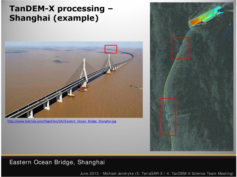
17 TanDEM-X processing Shanghai (example) Eastern Ocean Bridge, Shanghai, China

18 TanDEM-X processing Shanghai (example) Eastern Ocean Bridge, Shanghai
19 Spotlight Interferometry (Recap.) Problem (HS) Spotlight images Stripmap images Linear Doppler shift (in azimuth) Phase information is not suitable for InSAR after resampling Align image spectrum (of slave to master) (Amplitude information is not affected)
")
20 Spotlight Interferometry (Recap.) The antenna beam is gradually steered backwards while the satellite passes over the area of interest Sliding spotlight image geometry

21 Spotlight Interferometry Example Lüneburg Example Spotlight scene from Lüneburg, Germany
22 Spotlight Interferometry using open source sw. Dataset for testing TerraSAR-X Spotlight image (full scene) of Urulu, Australia. Image shows the Ayers rock. Sample dataset from Infoterra ASTRIUM. DLR 2009
23 Spotlight Interferometry using open source sw. Wrong Result in DORIS Doppler Shift in azimuth ON
24 Spotlight Interferometry using open source sw. Wrong Result in DORIS Doppler Shift in azimuth OFF
25 Spotlight Interferometry using open source sw. Our implementation: Shift the interpolation kernel during the resampling step. RS_METHOD RS_SHIFTAZI cc6p_sp (new code) OFF
26 Spotlight Interferometry using open source sw. Red line: The actual frequency for a single azimuth column. Black line: The modeled frequency.
27 Spotlight Interferometry using open source sw. This beam steering or beam sweeping technique leads to a positive Doppler shift in the upper image lines and a negative shift towards the last lines. Solution: Shift interpolation kernel in azimuth during resampling
28 Spotlight Interferometry using open source sw. Metadata contains Doppler polynomials. A frequency matrix is created by interpolating these along range time and azimuth. This matrix is used to shift the interpolation kernel in azimuth direction.
29 Spotlight Interferometry Reference M. Eineder, N. Adam, R. Bamler, N. Yague-Martinez, and H. Breit, Spaceborne Spotlight SAR Interferometry With TerraSAR-X, IEEE Transactions on Geoscience and Remote Sensing, vol. 47, no. 5, pp , May The paper covers more adjustments (filtering), which is not yet included.
30 Spotlight Interferometry using open source sw. Interferogram with modified cc6p_sp interpolation DORIS colorbar: jet Interferogram generated with DORIS using the cc6p_sp interpolation kernel. Temporal baseline is 11 days and perpendicular baseline is m with a height ambiguity of 34 m.
31 Spotlight Interferometry Las Vegas (example) TerraSAR-X TerraSAR-X flattened interferogram with amplitude image in background. Temporal baseline 110 days, perpendicular baseline: 48.1 m.
32 Spotlight Interferometry Las Vegas (example) TanDEM-X TanDEM-X flattened interferogram in radar coordinates with amplitude image in background. Subsets show hotels and the Convention Center in Las Vegas, USA. Temporal baseline 0 days, effective baseline: ~87 m.
33 Spotlight Interferometry Las Vegas (example) Time series of interferograms showing the convention centre in Las Vegas.
34 Spotlight Interferometry Las Vegas (example) Bistatic TanDEM-X TanDEM-X Coherence image. Temporal baseline 0 days, effective baseline: ~87 m.
35 Spotlight Interferometry Las Vegas (example) Monostatic TerraSAR-X TerraSAR-X Coherence image. Temporal baseline 110 days, perpendicular baseline: 48.1 m.
36 Spotlight Interferometry Coherence Comparison of TanDEM-X and TerraSAR-X coherence images
37 Spotlight Interferometry PS-InSAR Modified version of StaMPS 4-4 PS-InSAR analysis of Las Vegas using StaMPS. Modifications: Corregistration and Resampling Step
38 Spotlight Interferometry PS-InSAR analysis of Las Vegas, persistent scatter on roof of convention centre.
39 Conclusions Now available: Modified DORIS (beta) version for TerraSAR-X Spotlight processing Modified DORIS (beta) version for TanDEM-X bistatic processing and phase unwrapping Program to convert TanDEM-X data from 16bit to 32bit floating point New inputfiles for StaMPS to do PS-InSAR with spotlight images
40 Thank You! Questions?
TerraSAR-X Interferometry. Michael Eineder, Nico Adam Remote Sensing Technology Institute
 TerraSAR-X Interferometry Michael Eineder, Nico Adam Remote Sensing Technology Institute TerraSAR-X Contribution to Commissioning Phase: verify phase and geometric stability of instrument and SAR processor
Interferometric TOPS Chain Description
 www.dlr.de/hr > SEOM INSARAP INSARAP Workshop December 10, 2014 > Slide 1 SEOM INSARAP: Sentinel-1 InSAR Performance Study with TOPS Data ESA-ESRIN Contract 4000110587/14/I-BG Interferometric TOPS Chain
Radar images Università di Pavia Fabio Dell Acqua Gruppo di Telerilevamento
 Radar images Radar images radar image DNs linked to backscattered field Backscattered field depends on wave-target interaction, with different factors relevant to it: within-pixel coherent combination
POTENTIALS OF HIGH RESOLUTION TERRASAR-X IMAGES IN INSAR PROCESSING
 POTENTIALS OF HIGH RESOLUTION TERRASAR-X IMAGES IN INSAR PROCESSING FOR EARTH DEFORMATION AND ENVIRONMENTAL STUDIES Magdalena Niemiec 1 Abstract Accurate determination of topography and surface deformation
PI: Riccardo Lanari (IREA CNR) email:[email protected]
 email:lanari.r@irea.cnr.it") On the exploitation and validation of COSMO-SkyMed interferometric SAR data for digital terrain modelling and surface deformation analysis in extensive urban areas (ID: 1441) Project partners: Istituto
On the exploitation and validation of COSMO-SkyMed interferometric SAR data for digital terrain modelling and surface deformation analysis in extensive urban areas (ID: 1441) Project partners: Istituto
DEM products from TerraSAR-X & TanDEM-X. Nora Meyer zu Erpen // 25.01.2011
 DEM products from TerraSAR- & TanDEM- Nora Meyer zu Erpen // 25.01.2011 GEO-Information Services within Astrium and EADS Airbus Eurocopter Cassidian Astrium Turnover 2009: 4.8 billion Staff 2009: 15,000*
High Resolution 3D Earth Observation Data Analysis for Safeguards Activities
 High Resolution 3D Earth Observation Data Analysis for Safeguards Activities Pablo d'angelo a1, Cristian Rossi a, Christian Minet a, Michael Eineder a, Michael Flory b, Irmgard Niemeyer c a German Aerospace
Software Architecture Document (SAD) for the Interferometric Modules of the Next ESA SAR Toolbox (NEST)
 for the Interferometric Modules of the Next ESA SAR Toolbox (NEST)") Software Architecture Document (SAD) for the Interferometric Modules of the Next ESA SAR Toolbox (NEST) Contract number: 20809/07/I-LG Prepared by: PPO.labs Prepared for: The European Space Agency Revision
Software Architecture Document (SAD) for the Interferometric Modules of the Next ESA SAR Toolbox (NEST) Contract number: 20809/07/I-LG Prepared by: PPO.labs Prepared for: The European Space Agency Revision
I.D.I.O.T.: A FREE AND EASY-TO-USE SOFTWARE TOOL FOR DINSAR ANALYSIS
 I.D.I.O.T.: A FREE AND EASY-TO-USE SOFTWARE TOOL FOR DINSAR ANALYSIS A. Reigber, E. Erten, S. Guillaso, and O. Hellwich Berlin University of Technology, Computer Vision and Remote Sensing Franklinstr.
Satellites for Terrain Motion Mapping Terrafirma User Workshop Mining. Nico Adam
 Satellites for Terrain Motion Mapping Terrafirma User Workshop Mining Nico Adam Outline SAR / InSAR observation characteristic Sensors TSX, TDX ERS-1, ERS-2 Processing techniques D-InSAR PSI SBAS Acquisition
SARscape 4.3 Supported Sensors/Products (March 2011) - Spaceborne Sensors -
 - Spaceborne Sensors -") SARscape 4.3 Supported Sensors/Products (March 2011) - Spaceborne Sensors - ALOS PALSAR (provided by JAXA) In case of RAW (level 1.0) data, import is carried out within the Focusing Module. PALSAR RAW
SARscape 4.3 Supported Sensors/Products (March 2011) - Spaceborne Sensors - ALOS PALSAR (provided by JAXA) In case of RAW (level 1.0) data, import is carried out within the Focusing Module. PALSAR RAW
How To Write A Call To Action For Terrasar-X
 Doc.: TX-PGS-PL-4127 TerraSAR-X Announcement of Opportunity: Utilization of the TerraSAR-X Archive 1 Page: 2 of 11 TABLE OF CONTENTS TERRASAR-X... 1 ANNOUNCEMENT OF OPPORTUNITY: UTILIZATION OF THE TERRASAR-X
Radar interferometric techniques and data validation Terrafirma Essen, March 2011. Page 1
 Radar interferometric techniques and data validation Terrafirma Essen, March 2011 Page 1 Agenda Introduction to InSAR technology Different radarinterferometric techniques Validation of InSAR technology
Recent Advances in Pixel Localization Accuracy
 Recent Advances in Pixel Localization Accuracy U. Balss, X. Cong, M. Eineder, H. Breit, T. Fritz, B. Schättler Remote Sensing Technology Institute (IMF) German Aerospace Center (DLR) Outline Operational
Interferometric Synthetic Aperture Radar (SAR) Missions Employing Formation Flying
 Missions Employing Formation Flying") INVITED PAPER Interferometric Synthetic Aperture Radar (SAR) Missions Employing Formation Flying A German Earth satellite system is designed to produce data on forest structure, biomass, tectonic shifts
INVITED PAPER Interferometric Synthetic Aperture Radar (SAR) Missions Employing Formation Flying A German Earth satellite system is designed to produce data on forest structure, biomass, tectonic shifts
SAR Archive and Community Support Activities at UNAVCO
 SAR Archive and Community Support Activities at UNAVCO Scott Baker 1, Chris Crosby 1, Charles Meertens 1, Eric Fielding 2, Gwen Bryson 3, Brian Buechler 3, Jeremy Nicoll 3, Chaitanya Baru 4 1 UNAVCO, Boulder,
TerraSAR-X Applications Guide
 TerraSAR-X Applications Guide Extract: Maritime Monitoring: Oil Spill Detection April 2015 Airbus Defence and Space Geo-Intelligence Programme Line Maritime Monitoring: Oil Spill Detection Issue As the
Professional SAR Data Processing
 Professional SAR Data Processing SAR Tutorial at EUSAR 2012 in Nürnberg (Germany) Dr. Thomas Bahr The information contained in this document pertains to software products and services that are subject
Terrafirma Persistent Scatterer Processing Validation
 Terrafirma Persistent Scatterer Processing Validation Nico Adam (1), Alessandro Parizzi (1), Michael Eineder (1), Michele Crosetto () (1) Remote Sensing Technology Institute () Institute of Geomatics Signal
September 2008 E M A I L : I N F O @ C R E A S O. C O M H T T P : / / W W W. C R E A S O. C O M
 Technical Description in a Nutshell September 2008 C R E A S O G M B H T A L H O F S T R A S S E 3 2 A D - 8 2 2 0 5 G I L C H I N G T E L E F O N ( + 4 9-8 1 0 5 ) 3 7 8-0 F A X ( + 4 9-8 1 0 5 ) 3 7
AUTOMATIC INSAR SYSTEMATIC PROCESSING AND WEB BASED TOOL FOR EFFICIENT DATA MINING: APPLICATION TO VOLCANO MONITORING IN AFRICA
 AUTOMATIC INSAR SYSTEMATIC PROCESSING AND WEB BASED TOOL FOR EFFICIENT DATA MINING: APPLICATION TO VOLCANO MONITORING IN AFRICA N. d Oreye (1), and G. Celli (1) (1) National Museum of Natural History,
TerraSAR-X Image Product Guide. Basic and Enhanced Radar Satellite Imagery. Airbus Defence and Space Geo-Intelligence Programme Line
 TerraSAR-X Image Product Guide Geo-Intelligence Programme Line 1 Introduction TerraSAR-X and TanDEM-X are commercial German Synthetic Aperture Radar (SAR) Earth observation satellites, which were launched
Exploitation of historical satellite SAR archives for mapping and monitoring landslides at regional and local scale
 Exploitation of historical satellite SAR archives for mapping and monitoring landslides at regional and local scale (A. Ferretti (TRE), A. Tamburini (TRE), M. Bianchi (TRE), M. Broccolato (Regione Valle
Cluster Applied Remote Sensing TerraSAR-X Ground Segment Basic Product Specification Document. Ground Segment. Basic Product Specif ication Document
 Page: 1 of 108 Ground Segment Basic Product Specif ication Document CAF - Cluster Applied Remote Sensing editors: 30.3.2009 T. Fritz, M. Eineder Date SAR ~rbduct Verification Responsible & TMSP Team reviewed:
Using advanced InSAR techniques as a remote tool for mine site monitoring
 The Southern African Institute of Mining and Metallurgy Slope Stability 2015 D. Colombo and B. MacDonald Using advanced InSAR techniques as a remote tool for mine site monitoring D. Colombo* and B. MacDonald
June 2011. TerraSAR-X-based Flood Mapping Service
 June 2011 TerraSAR-X-based Flood Mapping Service Service TerraSAR-X-based Flood Mapping Product Flood extent map Product specifications Flood mask / water mask Input / output data Summary Content Date
GPS Precise Point Positioning as a Method to Evaluate Global TanDEM-X Digital Elevation Model
 GPS Precise Point Positioning as a Method to Evaluate Global TanDEM-X Digital Elevation Model 7 th FIG Regional Conference TS 1C Advances in GNSS Positioning and Applications I Volker Schwieger 1, Jürgen
Focus Earth The Velingara Circular Structure A meteorite impact crater?
 Focus Earth The Velingara Circular Structure A meteorite impact crater? S. Wade Institut des Sciences de la Terre, Faculté des Sciences et Techniques, Université Cheikh Anta Diop, Dakar-Fann, Sénégal M.
GEOCODING OF TERRASAR-X DATA
 GEOCODING OF TERRASAR-X DATA A. Roth, M. Huber, D. Kosmann DLR, German Remote Sensing Data Center, Oberpfaffenhofen, D-82234 Wessling, Germany - (Achim.Roth, Martin.Huber, Deltev.Kosmann)@dlr.de KEY WORDS:
The DLR Multi Mission EO Ground Segment
 The DLR Multi Mission EO Ground Segment Payload Ground Segment Erhard Diedrich Remote Sensing Workshop Mexico 22-24 April 2008 DLR Ground Segment for Earth Observation: Servicing GMES, national and commercial
Microwaves and Radar Institute
 Institut für Hochfrequenztechnik und Radarsysteme Microwaves and Radar Institute Status Report 2000-2005 Research Results and Projects Published by German Aerospace Center A member of the Helmholtz Society
Information Contents of High Resolution Satellite Images
 Information Contents of High Resolution Satellite Images H. Topan, G. Büyüksalih Zonguldak Karelmas University K. Jacobsen University of Hannover, Germany Keywords: satellite images, mapping, resolution,
Big Data Analytics for Detailed Urban Mapping. Mihai Datcu Daniela Molina Espinoza, Octavian Dumitru, Gottfried Schwarz
 Big Data Analytics for Detailed Urban Mapping Mihai Datcu Daniela Molina Espinoza, Octavian Dumitru, Gottfried Schwarz Big Data: The German EO Digital Library The data access Folie 2 Information vs. Data
Günter Seeber. Satellite Geodesy 2nd completely revised and extended edition
 Günter Seeber Satellite Geodesy 2nd completely revised and extended edition Walter de Gruyter Berlin New York 2003 Contents Preface Abbreviations vii xvii 1 Introduction 1 1.1 Subject of Satellite Geodesy...
Infoterra TanDEM-X Science Meeting Commercial Exploitation
 Infoterra TanDEM-X Science Meeting Commercial Exploitation Bernd Scheuchl & Jürgen Janoth 24.11.2008 Contents Introduction of Infoterra Commercial Exploitation Strategy Final DEM Customized HRTI-4 DEMs
TerraSAR-X Products Tips and Tricks
 TerraSAR-X Products Tips and Tricks Thomas Fritz Helko Breit Michael Eineder (L1b Annotation, Geometry, Radiometry) (Processing, Spectral Properties) (InSAR-Processing incl. Spotlight) DLR Remote Sensing
STUDY ON RADAR DIFFERENTIAL INTERFEROMETRY TECHNOLOGY AND IT S APPLICATION TO MANI EARTHQUAKE USING ERS-1/2 SAR DATA: A CASE STUDY IN CHINA
 STUDY ON RADAR DIFFERENTIAL INTERFEROMETRY TECHNOLOGY AND IT S APPLICATION TO MANI EARTHQUAKE USING ERS-1/2 SAR DATA: A CASE STUDY IN CHINA Qulin Tan a, *, Siwen i b, in Wang a, Songlin Yang a a School
HIGH RESOLUTION MONITORING OF CAMPI FLEGREI (NAPLES, ITALY) BY EXPLOITING TERRASAR-X DATA: AN APPLICATION TO SOLFATARA CRATER
 BY EXPLOITING TERRASAR-X DATA: AN APPLICATION TO SOLFATARA CRATER") HIGH RESOLUTION MONITORING OF CAMPI FLEGREI (NAPLES, ITALY) BY EXPLOITING TERRASAR-X DATA: AN APPLICATION TO SOLFATARA CRATER Christian Minet (1), Kanika Goel (1), Ida Aquino (2), Rosario Avino (2), Giovanna
HIGH RESOLUTION MONITORING OF CAMPI FLEGREI (NAPLES, ITALY) BY EXPLOITING TERRASAR-X DATA: AN APPLICATION TO SOLFATARA CRATER Christian Minet (1), Kanika Goel (1), Ida Aquino (2), Rosario Avino (2), Giovanna
German Earth Observation Systems and Programs Capacities for nation building
 German Earth Observation Systems and Programs Capacities for nation building German Aerospace Center, DLR, Earth Observation Center, EOC German Remote Sensing Data Center, DFD Gunter Schreier Deputy Director
Synthetic Aperture Radar: Principles and Applications of AI in Automatic Target Recognition
 Synthetic Aperture Radar: Principles and Applications of AI in Automatic Target Recognition Paulo Marques 1 Instituto Superior de Engenharia de Lisboa / Instituto de Telecomunicações R. Conselheiro Emídio
POLINSAR DATA PROCESSING WITH RAT (RADAR TOOLS)
") POLINSAR DATA PROCESSING WITH RAT (RADAR TOOLS) Maxim Neumann, Andreas Reigber, Stéphane Guillaso, Marc Jäger and Olaf Hellwich Technical University Berlin, Department of Computer Vision and Remote Sensing
POLINSAR DATA PROCESSING WITH RAT (RADAR TOOLS) Maxim Neumann, Andreas Reigber, Stéphane Guillaso, Marc Jäger and Olaf Hellwich Technical University Berlin, Department of Computer Vision and Remote Sensing
CLASSIFICATION ACCURACY INCREASE USING MULTISENSOR DATA FUSION
 CLASSIFICATION ACCURACY INCREASE USING MULTISENSOR DATA FUSION Aliaksei Makarau, Gintautas Palubinskas, and Peter Reinartz German Aerospace Center (DLR) German Remote Sensing Data Center (DFD) bzw. Remote
German Aerospace Center A member of the Helmholtz Association. Microwaves and Radar Institute. Digital- & Offsetdruck Wolfertstetter KG, Gilching
 Institute s Brochure Microwaves and Radar Institute Overview of Projects and Research Activities 1 German Aerospace Center A member of the Helmholtz Association Microwaves and Radar Institute Director
Map World Forum Hyderabad, India Introduction: High and very high resolution space images: GIS Development
 Very high resolution satellite images - competition to aerial images Dr. Karsten Jacobsen Leibniz University Hannover, Germany [email protected] Introduction: Very high resolution images taken
A Beginner s Guide to Interferometric SAR Concepts and Signal Processing
 I. INTRODUCTION A Beginner s Guide to Interferometric SAR Concepts and Signal Processing MARK A. RICHARDS, Senior Member, IEEE Georgia Institute of Technology Interferometric synthetic aperture radar (IFSAR,
Digital Remote Sensing Data Processing Digital Remote Sensing Data Processing and Analysis: An Introduction and Analysis: An Introduction
 Digital Remote Sensing Data Processing Digital Remote Sensing Data Processing and Analysis: An Introduction and Analysis: An Introduction Content Remote sensing data Spatial, spectral, radiometric and
Wide Area Persistent Scatterer Interferometry: Algorithms and Examples
 Wide Area Persistent Scatterer Interferometry: Algorithms and Examples Nico Adam, Fernando Rodriguez Gonzalez, Alessandro Parizzi, Werner Liebhart with contributions of Ramon Brcic and Xiao Ying Cong ca.
CHARACTERIZATION AND MODELLING OF GEOLOGICAL INSTABILITIES THROUGH REMOTE SENSING TECHNIQUES AND NUMERICAL SIMULATIONS
 CHARACTERIZATION AND MODELLING OF GEOLOGICAL INSTABILITIES THROUGH REMOTE SENSING TECHNIQUES AND NUMERICAL SIMULATIONS Ph.D. candidate: GIULIA TESSARI, III course Tutor: Dott. MARIO FLORIS Cycle: XXVII
The most widely used active remote sensing systems include:
 Active and Passive Remote Sensing Passive remote sensing systems record EMR that is reflected (e.g., blue, green, red, and near-infrared light) or emitted (e.g., thermal infrared energy) from the surface
Passive remote sensing systems record electromagnetic energy that was reflected (e.g., blue, green, red, and near-infrared light) or emitted (e.g.
 or emitted (e.g.") CHAPTER 9: Active and Passive Microwave RS REFERENCE: Remote Sensing of the Environment John R. Jensen (2007) Second Edition Pearson Prentice Hall Passive Remote Sensing Passive remote sensing systems
CHAPTER 9: Active and Passive Microwave RS REFERENCE: Remote Sensing of the Environment John R. Jensen (2007) Second Edition Pearson Prentice Hall Passive Remote Sensing Passive remote sensing systems
Part C. InSAR processing: a mathematical approach
 Part C InSAR processing: a mathematical approach Statistics of SAR and InSAR images 1. Statistics of SAR and InSAR images 1.1 The backscattering process 1.1.1 Introduction The dimension of the resolution
Big Data Challenge: Mining Heterogeneous Data. Prof. Mihai Datcu. German Aerospace Center (DLR) Munich Aerospace Faculty
 Munich Aerospace Faculty") Big Data Challenge: Mining Heterogeneous Data Prof. Mihai Datcu German Aerospace Center (DLR) Munich Aerospace Faculty Sensing & Big Data Big Data: - Computer hardware and the Cloud - Storage Challenges
Big Data Challenge: Mining Heterogeneous Data Prof. Mihai Datcu German Aerospace Center (DLR) Munich Aerospace Faculty Sensing & Big Data Big Data: - Computer hardware and the Cloud - Storage Challenges
Monitoring a Changing Environment with Synthetic Aperture Radar. Alaska Satellite Facility National Park Service Don Atwood
 Monitoring a Changing Environment with Synthetic Aperture Radar Don Atwood Alaska Satellite Facility 1 Entering the SAR Age 2 SAR Satellites RADARSAT-1 Launched 1995 by CSA 5.6 cm (C-Band) HH Polarization
Sentinel-1 Mission Overview
 Sentinel-1 Mission Overview Pierre Potin Sentinel-1 Mission Manager, ESA Advanced Course on Radar Polarimetry ESRIN, Frascati, 19 January 2011 Global Monitoring for Environment and Security GMES is established
Microwaves and Radar Institute
 Microwaves and Radar Institute Research and Projects Alberto Moreira German Aerospace Center DLR Oberpfaffenhofen, Germany Microwaves and Radar Institute 30+ years of experience in SAR systems and applications
High Resolution RF Analysis: The Benefits of Lidar Terrain & Clutter Datasets
 0 High Resolution RF Analysis: The Benefits of Lidar Terrain & Clutter Datasets January 15, 2014 Martin Rais 1 High Resolution Terrain & Clutter Datasets: Why Lidar? There are myriad methods, techniques
Signal Processing for Synthetic Aperture Radars
 IWSSIP 1-17th International Conference on Systems, Signals and Image Processing Signal Processing for Synthetic Aperture Radars Žarko Čučej Uniersity of Maribor, Faculty of Electrical Engineering and Computer
TerraSAR-X capabilities and constrains for acquisitions over the polar regions. Dana Floricioiu
 TerraSAR-X capabilities and constrains for acquisitions over the polar regions Dana Floricioiu STG IPY SAR Workshop Montreal 5/6 March 2008 TerraSAR-X Features Multi-Mode Imaging StripMap (High-Resolution)
DIGITAL ELEVATION MODEL DATABASE W42 - A SCALABLE SYSTEM FOR SPATIAL DATA
 DIGITAL ELEVATION MODEL DATABASE W42 - A SCALABLE SYSTEM FOR SPATIAL DATA M. Habermeyer, U. Marschalk, A. Roth German Aerospace Center (DLR),German Remote Sensing Data Center (DFD) 82234 Wessling, Germany,(martin.habermeyer,ursula.marschalk,achim.roth)@dlr.de
Введение в спутниковую радиолокацию: Радиолокаторы с синтезированной апертурой (РСА) Introduction to satellite radars: Synthetic Aperture Radars (SAR)
 Introduction to satellite radars: Synthetic Aperture Radars (SAR)") Введение в спутниковую радиолокацию: Радиолокаторы с синтезированной апертурой (РСА) Introduction to satellite radars: Synthetic Aperture Radars (SAR) проф. Бертран Шапрон IFREMER / ЛСО РГГМУ Prof. Bertrand
Введение в спутниковую радиолокацию: Радиолокаторы с синтезированной апертурой (РСА) Introduction to satellite radars: Synthetic Aperture Radars (SAR) проф. Бертран Шапрон IFREMER / ЛСО РГГМУ Prof. Bertrand
Remote Sensing an Introduction
 Remote Sensing an Introduction Seminar: Space is the Place Referenten: Anica Huck & Michael Schlund Remote Sensing means the observation of, or gathering information about, a target by a device separated
Real Time Services for Space Applications Holger Maass, Susanne Lehner
 Real Time Services for Space Applications Holger Maass, Susanne Lehner [email protected] German Remote Sensing Data Center ( DFD ) with 2 locations in Germany Neustrelitz in Mecklenburg-Vorpommern Oberpfaffenhofen
New Space Capabilities for Maritime Surveillance
 www.dlr.de ESA Blue Growth Marititime College, Cork, Ireland 17.4..2013 New Space Capabilities for Maritime Surveillance Susanne Lehner German Aerospace Center DLR Remote Sensing Technology Institute DLR
MULTIBASELINE POLINSAR MODULE FOR SAR DATA PROCESSING AND ANALYSIS IN RAT (RADAR TOOLS)
") MULTIBASELINE POLINSAR MODULE FOR SAR DATA PROCESSING AND ANALYSIS IN RAT (RADAR TOOLS) Maxim Neumann 2,1, Andreas Reigber 1, Marc Jäger 1, Stéphane Guillaso 1 and Olaf Hellwich 1 1 Berlin University of
MULTIBASELINE POLINSAR MODULE FOR SAR DATA PROCESSING AND ANALYSIS IN RAT (RADAR TOOLS) Maxim Neumann 2,1, Andreas Reigber 1, Marc Jäger 1, Stéphane Guillaso 1 and Olaf Hellwich 1 1 Berlin University of
Obtaining and Processing MODIS Data
 Obtaining and Processing MODIS Data MODIS is an extensive program using sensors on two satellites that each provide complete daily coverage of the earth. The data have a variety of resolutions; spectral,
TerraSAR X and TanDEM X satellite missions update & other activities Dana Floricioiu German Aerospace Center (DLR), Remote Sensing Technology
, Remote Sensing Technology") TerraSAR X and TanDEM X satellite missions update & other activities Dana Floricioiu German Aerospace Center (DLR), Remote Sensing Technology Institute, Oberpfaffenhofen, Germany PSTG 2 12 14 June 2012
TerraSAR X and TanDEM X satellite missions update & other activities Dana Floricioiu German Aerospace Center (DLR), Remote Sensing Technology Institute, Oberpfaffenhofen, Germany PSTG 2 12 14 June 2012
DESCW: PC Software Supporting Remote Sensing Data
 r bulletin 97 march 1999 DESCW: PC Software Supporting Remote Sensing Data S. D Elia Earth Remote Sensing Exploitation Division, ESA Directorate for Application Programmes, ESRIN, Frascati, Italy R. Biasutti
Satellite Altimetry Missions
 Satellite Altimetry Missions SINGAPORE SPACE SYMPOSIUM 30 TH SEPTEMBER 2015 AUTHORS: LUCA SIMONINI/ ERICK LANSARD/ JOSE M GONZALEZ www.thalesgroup.com Table of Content General Principles and Applications
Data and Information Management for EO Data Centers. Eberhard Mikusch German Aerospace Center - German Remote Sensing Data Center
 Data and Information Management for EO Data Centers Eberhard Mikusch German Aerospace Center - Mexico, 23. 04 2008 Earth Observation System Environment at DLR/DFD 10010 00101 Radar 10010 00101 Atmospheric
COMPARISON OF SRTM AND 25K TOPOGRAPHIC MAPS IN TURKEY
 COMPARISON OF SRTM AND 25K TOPOGRAPHIC MAPS IN TURKEY Oztug Bildirici 1, Aydin Ustun, Necla Ulugtekin 2, H. Zahit Selvi 1, Alpay Abbak 1, Ilkay Bugdayci 1, A. Ozgur Dogru 2 1 Selcuk University, Faculty
Case Study Australia. Dr John Dawson A/g Branch Head Geodesy and Seismic Monitoring Geoscience Australia. Chair UN-GGIM-AP WG1 Chair APREF.
 Case Study Australia Dr John Dawson A/g Branch Head Geodesy and Seismic Monitoring Geoscience Australia Chair UN-GGIM-AP WG1 Chair APREF Page 1 Overview 1. Australian height system Australian Height Datum
Two primary advantages of radars: all-weather and day /night imaging
 Lecture 0 Principles of active remote sensing: Radars. Objectives: 1. Radar basics. Main types of radars.. Basic antenna parameters. Required reading: G: 8.1, p.401-40 dditional/advanced reading: Online
SAR Geocoding: Data and Systems
 Gunter Schreier (Ed.) SAR Geocoding: Data and Systems Tschnisthe Hach-d^s Darmstadt lehrstubi f 0 r Pho'ogrammetria unci Ka rt ogrcphis In v.-nr. ^ ^ WICHMANN Contents Foreword (G. Schreier) 1 1 The ERS-1
ENVI Classic Tutorial: Atmospherically Correcting Hyperspectral Data using FLAASH 2
 ENVI Classic Tutorial: Atmospherically Correcting Hyperspectral Data Using FLAASH Atmospherically Correcting Hyperspectral Data using FLAASH 2 Files Used in This Tutorial 2 Opening the Uncorrected AVIRIS
Monitoring and Assessing Geohazards in Permafrost Terrain using Spaceborne Synthetic Aperture Radar (SAR)
") Monitoring and Assessing Geohazards in Permafrost Terrain using Spaceborne Synthetic Aperture Radar (SAR) Pierre-Jean Alasset & Joseph Chamberland C-CORE, Ottawa, Ontario, Canada Jerry English, Des Power
Monitoring and Assessing Geohazards in Permafrost Terrain using Spaceborne Synthetic Aperture Radar (SAR) Pierre-Jean Alasset & Joseph Chamberland C-CORE, Ottawa, Ontario, Canada Jerry English, Des Power
Appendix B. Introduction to Landslide Evaluation Tools Mapping, Remote Sensing, and Monitoring of Landslides
 Appendix B. Introduction to Landslide Evaluation Tools Mapping, Remote Sensing, and Monitoring of Landslides 66 The Landslide Handbook A Guide to Understanding Landslides Part 1. Mapping Maps are a useful
PolSARpro v5.0. An ESA Educational, Free and Open Source Toolbox for Polarimetric SAR Data Analysis. Eric POTTIER
 PolSARpro v5.0 An ESA Educational, Free and Open Source Toolbox for Polarimetric SAR Data Analysis Eric POTTIER A Bit Of History CONTEXT The initiative development of PolSARpro Software is a direct result
ROSA ESA - DLR Course 2009 RADAR REMOTE SENSING Day 4-5
 ROSA ESA - DLR Course 2009 RADAR REMOTE SENSING Day 4-5 Dr. Jan-Peter Mund, André Twele & Sandro Martinis German Remote Sensing Data Center (DFD) German Aerospace Center (DLR) RADAR REMOTE SENSING Introduction
Synthetic Aperture Radar (SAR) Imaging using the MIT IAP 2011 Laptop Based Radar*
 Imaging using the MIT IAP 2011 Laptop Based Radar*") Synthetic Aperture Radar (SAR) Imaging using the MIT IAP 2011 Laptop Based Radar* Presented at the 2011 MIT Independent Activities Period (IAP) Gregory L. Charvat, PhD 24 January 2011 *This work is sponsored
Synthetic Aperture Radar (SAR) Imaging using the MIT IAP 2011 Laptop Based Radar* Presented at the 2011 MIT Independent Activities Period (IAP) Gregory L. Charvat, PhD 24 January 2011 *This work is sponsored
How To Monitor Sea Level With Satellite Radar
 Satellite Altimetry Wolfgang Bosch Deutsches Geodätisches Forschungsinstitut (DGFI), München email: [email protected] Objectives You shall recognize satellite altimetry as an operational remote sensing
Radar Interferometric and Polarimetric Possibilities for Determining Sea Ice Thickness
 Radar Interferometric and Polarimetric Possibilities for Determining Sea Ice Thickness by Scott Hensley, Ben Holt, Sermsak Jaruwatanadilok, Jeff Steward, Shadi Oveisgharan Delwyn Moller, Jim Reis, Andy
AUTOMATED DEM VALIDATION USING ICESAT GLAS DATA INTRODUCTION
 AUTOMATED DEM VALIDATION USING ICESAT GLAS DATA Mary Pagnutti Robert E. Ryan Innovative Imaging and Research Corp. Building 1103, Suite 140C Stennis Space Center, MS 39529 [email protected] [email protected]
National Snow and Ice Data Center
 National Snow and Ice Data Center This data set (NSIDC-0484), part of the NASA Making Earth System Data Records for Use in Research Environments (MEaSUREs) Program, provides the first comprehensive, high-resolution,
Multisensor Data Integration in O&G Business Lutz Petrat Hélène Lemonnier Michael Hall
 Multisensor Data in O&G Business Lutz Petrat Hélène Lemonnier Michael Hall ESA Oil and Gas Workshop 15/09/2010, Frascati, Italy Satellite Products and Services during a typical O&G project Project Life
Radar imaging: an industrial point of view. From the beginning to its applications to large systems
 Radar imaging: an industrial point of view. From the beginning to its applications to large systems Alfonso FARINA (FREng, FIET, FIEEE, EURASIP Fellow Engineering Director of Large Systems Business Unit,
A comparison of radio direction-finding technologies. Paul Denisowski, Applications Engineer Rohde & Schwarz
 A comparison of radio direction-finding technologies Paul Denisowski, Applications Engineer Rohde & Schwarz Topics General introduction to radiolocation Manual DF techniques Doppler DF Time difference
ENVI Classic Tutorial: Atmospherically Correcting Multispectral Data Using FLAASH 2
 ENVI Classic Tutorial: Atmospherically Correcting Multispectral Data Using FLAASH Atmospherically Correcting Multispectral Data Using FLAASH 2 Files Used in this Tutorial 2 Opening the Raw Landsat Image
PolSARpro v2.0 Software Training Course
 PolSARpro v2.0 Software Training Course Training Course Programme 09h00 09h30 09h30 11h00 11h00 11h30 11h30 12h00 12h00 13h00 Topic 1: General Presentation of the PolSARpro Software Topic 2: PolSARpro
Prediction of Storm Surge using Space Data. Susanne Lehner German Aerospace Center
 Prediction of Storm Surge using Space Data Susanne Lehner German Aerospace Center Existing Crisis Information State of the Art of Satellite Crisis Information (ZKI) Mapping after the storm www.zki.de
ERS-ENVISAT ENVISAT deformation time-series analysis: a unique opportunity to investigate long term surface deformation of large areas
 ERS-ENVISAT ENVISAT deformation time-series analysis: a unique opportunity to investigate long term surface deformation of large areas R. Lanari 1, P. Berardino 1, M. Bonano 1,2, F. Casu 1, A. Manconi
Comparison of ALOS-PALSAR and TerraSAR-X Data in terms of Detecting Settlements First Results
 ALOS 2008 Symposium, 3-7 November Rhodes, Greece Comparison of ALOS-PALSAR and TerraSAR-X Data in terms of Detecting Settlements First Results Thomas Esch*, Achim Roth*, Michael Thiel, Michael Schmidt*,