CLARREO Mission Formulation
|
|
|
- Clement Waters
- 7 years ago
- Views:
Transcription
1 CLARREO Mission Formulation Stephen Sandford CLARREO Mission Formulation Manager 2009 Decadal Survey Symposium February 11-12,

2 CLARREO Overview Mission formulation is underway at Langley The key elements of this mission are understood Technology challenges identified: no show stoppers Mission design studies began in December 2008 On track for Mission Concept Review in Fall 2009 CLARREO can be ready for launch in 2015

3 What is CLARREO? Climate Absolute Radiance and Refractivity Observatory CLARREO is a climate-focused mission Decadal-scale trend detection Improvement and testing of climate predictions Calibration is the foundation of CLARREO Delivers on-orbit S.I. traceability of measurements Provides calibration of operational and research sensors Joint NASA / NOAA mission NOAA portion of CLARREO is the continuation of solar irradiance and earth radiation budget observations (TSIS and CERES) 3

4 Earth Science Questions How is the global Earth system changing? What are the primary causes of change in the Earth system? How does the Earth system respond to natural and human-induced changes? What are the consequences for human civilization? How will the Earth system change in the future? CLARREO represents the beginning of a true climate observing system specifically designed with the accuracy required to answer these questions 4

5 CLARREO s role in the Climate Observing / Modeling System

6 How does CLARREO Deliver? CLARREO provides: SI traceable calibration of its observations at the required accuracy to detect decadal-scale climate change in key climate variables Wavelength/space/time/angle sampling sufficient to sampling noise (random) and alias (changing bias) to a level well below that of decadal-scale climate change Observations sufficient to determine changes in climate variable shown by climate models to be key to understanding past and future climate change Select orbits and instrument pointing, spectral resolution, spectral coverage in order to assure that CLARREO can calibrate other solar & infrared sensors in LEO and GEO orbits 6

7 Mission Science Study Approach Mission Science Study Goals Clarify mission requirements to ensure climate science and NASA s performance objectives are met, future costs are contained, and delays are minimized. Respond to several key areas of concern Clearer definition of science requirements Greater involvement of the climate modeling community More rigorous and detailed analysis of projected costs Deeper understanding of the trade space of science value/cost Science studies are based on key questions derived from community input The mission objectives are defined by the Decadal Survey Two Community Workshops have been held to clarify objectives The Mission Science Study Team was formed primarily of the lead authors of the 3 Decadal Survey white papers that were used to define CLARREO along with representatives of the global climate modeling community Team focused on defining a mission to fully meet the DS objectives

8 Mission Science Study Organizations NASA Langley Lead (ERBE, CERES, FIRST, GIFTS, INFLAME, CALIPSO) NASA GSFC (MODIS, VIIRS, SeaWiFS, Landsat) Harvard University (INTESSA, IR benchmarking) Univ. of Wisconsin (CrIS, IASI, S-HIS, blackbodies) CU-LASP (Total and Spectral solar irradiance) JPL (AIRS, TES) 3 Climate Modeling Groups: NCAR/DOE, NOAA/GFDL, NASA GISS NIST Potential UK/NPL collaboration on solar reflectance part of CLARREO mission based on proposed TRUTHS mission. 3 CLARREO relevant IIPs: LaRC, UW, LASP. 1 international equivalent IIP: NPL on cooled active cavity 8

9 Mission Science Study Accomplishments First CLARREO Community Workshop held July 2007 First CLARREO Team Meeting held April 30 - May 2 in Newport News, VA Reached team-wide consensus on highest level science objectives Second CLARREO Community Workshop held October 2008 Presented results from on-going science trade studies and Instrument Incubator projects for community comment Clarification of the key science objectives General consensus concerning CLARREO s role Represents the beginning of a true climate observing system CLARREO complements (does not replace) process missions Draft Workshop Report completed Solar instrument science team meeting held January 2009 Reviewed requirements for radiance benchmarks, intercalibration, and polarization Results will be used to produce RFP on solar instrument concepts Second Team meeting scheduled for April 2009 to confirm science requirements Presentations at IGARSS, SPIE, CALCON, AMS, and a 51-paper AGU session Presentations from all meetings available on CLARREO web site

10 Mission Science Measurement Objectives CLARREO provides the S.I. traceable absolute accuracy in infrared and solar reflected spectra and GPS radio occultation refractivities needed to observe decadal climate change and test and improve climate predictions. The CLARREO full spectra will extend and expand the information content to a wide range of climate variables at climate change accuracy. CLARREO anchors the research and operational solar and infrared sensors at climate change accuracy through inter-calibration, providing the first NIST in Orbit. CLARREO provides the first full infrared (IR) spectra by including the far-ir which is half of the Earth s emitted radiation, and the bulk of the water vapor greenhouse effect. 10

11 Integrated Mission Design Initial Integrated Mission Design Study (December 2008) Develop spacecraft sizing, cost estimates and operational concepts that cover the current mission trade space. Generate mass, power and cost data in order to support key decision points necessary to define a baseline CLARREO mission concept. Develop operational scenarios to identify number of satellites required to meet the accuracy goals. Document trade studies, potential instrument technology readiness issues and mission issues. Identify required mission trade studies. Integrated Mission Design Study Results 32 payload/spacecraft/launch options were analyzed Identified major cost drivers Developed preliminary launch vehicle and spacecraft sizes Solid preparation for mission design trades and architecture studies

12 Mission Design Status Results allowed us to narrow the trade space to 3 likely mission implementations More detailed engineering analysis underway Used with science trade study results to select baseline mission for MCR Worked with Mission Scientist to define specific configurations to deliver required accuracy, sampling and information content To meet all DS Survey objectives the mission elements required: 2-3 launch vehicles, Taurus meets all needs 2-3 spacecraft, RSDO capability sufficient Payload could consist of 14 instruments Ground stations currently available are sufficient All orbits are polar or highly inclined Currently working to achieve a design that minimizes cost and complexity

13 Technical challenges SI traceable calibration plan from lab to orbit Develop radiometric error budget to identify instrument engineering challenges Appropriate on-orbit calibration blackbodies On-orbit calibration system key to achieving required accuracy Far-IR beamsplitter and detector IR detector elements sensitive from 15 to 50 µm that do not require cryogenic cooling SI traceable blackbody radiance standards for wavelengths beyond 15 µm Robust beamsplitters with continuous high-efficiency over the full 5-50 µm Solar Enable on-orbit end-to-end spatial/spectral imager radiometric calibrations and degradation tracking with 0.3% SI traceable accuracy

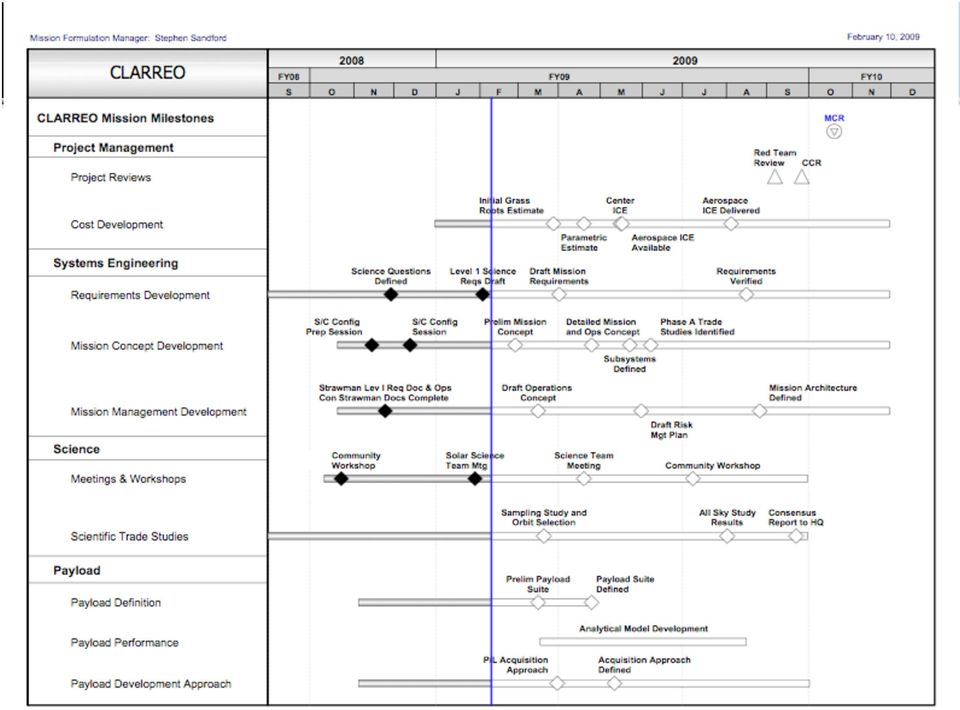
14 CLARREO Integrated Master Schedule
15 Mission Implementation Business Office Systems Engineering Mission Formulation Office Project Office Science Team Chief Safety Officer Payload Manager Calibration Manager Mission I & T Manager Spacecraft Manager MOS/GDS Manager Launch Services Manager GPS Occultation Instrument Solar Spectrometer Payload to Spacecraft Integration Attitude Control/Propulsion Subsystem Ground Stations Launch Vehicle Solar Spectrometer Mid-IR Spectrometer Spacecraft to Launch Vehicle Integration Power Subsystem Communications Launch Operations Mid-IR Spectrometer Far-IR Spectrometer C&DH Subsystem S/C Operations Far-IR Spectrometer Thermal Subsystem Payload Operations Mechanical Subsystem Data Processing

16 Workforce and Budget Phasing

17 Program Integration Items for Discussion NIST Calibration is critical for all DS missions Launch vehicle selection Science team solicitation Data Processing and Archive Infrastructure International partnering Decadal climate change observations Agency responsibilities and accounting of costs Relation of observing system with climate modeling CLARREO and what else? GPSRO is crucial Aerosol polarimetry data continuity between Glory and ACE

18 Climate Absolute Radiance and Refractivity Observatory (CLARREO) Mission Science CLARREO provides the S.I. traceable absolute accuracy in infrared and solar reflected spectra needed to observe decadal climate change and verify climate predictions. The CLARREO full spectra will extend and expand the information content to a wide range of climate variables at climate change accuracy. CLARREO anchors the research and operational solar and infrared sensors at climate change accuracy through intercalibration, providing the first NIST in Orbit. CLARREO provides the first full infrared (IR) spectra by including the far-ir which is half of the Earth s emitted radiation, and the bulk of the water vapor greenhouse effect. CLARREO provides the first full solar reflected spectra from the Earth at climate change accuracy. Defining CLARREO The study plan represents an integrated strategy that engages climate scientists, modelers, satellite instrument teams and calibration experts from: - NASA LaRC (lead), GSFC, and JPL - U.C. Berkeley / GISS / GFDL - Harvard University - University of Wisconsin-Madison - Laboratory for Atmospheric and Space Physics - Contributing, but not funded: National Institute of Standards and Technology 3 CLARREO relevant IIPs: LaRC, UW, LASP Potential UK/NPL collaboration on solar reflectance part of CLARREO How Does CLARREO Deliver? Sacrifice spatial resolution and coverage (nadir, 100-km fov) to enable reduced instrument mass, longer dwell times, smaller optics, and higher accuracy than other spectrometers like AIRS or CrIS or SCHIAMACHY. Improve calibration accuracy by a factor of 2 to 3 in the infrared spectrum and a factor of 10 in the solar reflected spectrum. Accuracy requirements designed for decadal change signals. Select orbits and field of view so CLARREO can provide direct spectral radiance benchmarks for decadal climate change, especially infrared spectra. Select orbits and instrument pointing, spectral resolution, spectral coverage in order to assure that CLARREO can calibrate other solar & infrared sensors in leo and geo orbits. Goals of FY08 - FY09 Studies Clarify mission requirements to ensure not only climate science, but also that NASA s performance objectives are met, future costs are contained, and delays are minimized. Respond to several key areas of concern Clearer definition of science requirements Greater involvement of the climate modeling community More rigorous and detailed analysis of projected costs Deeper understanding of the trade space of science value/cost Working towards a potential Mission Concept Review in late FY09 / early FY10. 18

19 CLARREO POCs and Website Program Scientist Don Anderson HQ Program Executive Richard Slonaker HQ Mission Scientist Bruce Wielicki LaRC Mission Formulation Manager Stephen Sandford LaRC Mission Formulation Science Lead David Young LaRC Mission Chief Engineer Mike Gazarik LaRC Website:

20 Thank You
21 Baseline Mission from the Decadal Survey Three satellites in 90 orbits to provide accurate temporal sampling Instruments Redundant hyperspectral IR spectrometers on each satellite cm-1 with 1 cm-1 resolution Nadir viewing with ~100 km FOV Accuracy goal: 0.1 K (3 σ) Hyperspectral solar spectrometers on third satellite nm with 15 nm resolution Accuracy goal: 3 parts per 1000 GPS radio occultation receivers on each satellite This is the starting baseline, but we are now working to provide a much more rigorous determination of CLARREO requirements 21
22 Key Elements of the CLARREO Mission 22
23 Calibration is the Foundation of CLARREO Dykema et. al CLARREO requires complete calibration traceability during all phases of development through operations on orbit Demonstrating on-orbit traceability will impact the accuracy of all future climate sensors Technology can be incorporated into future designs Operational sensors can be designed to make optimal use of CLARREO intercalibration 23
24 CLARREO Enables Climate Trend Detection Test for human influence Test climate models Temperature Trends: Error vs. Detection CLARREO will provide spectral radiances and refractivities of sufficient accuracy to detect decadal scale climate trends Anderson et. al The documented, verifiable accuracy of the CLARREO data record will enable trend detection with a shorter time record Unscrambling the trends has been demonstrated for clear-sky IR and GPS 24
25 CLARREO Reduces Climate Model Uncertainty The range of estimates of climate sensitivity arises from uncertainties in the climate models and their internal feedbacks, particularly those related to clouds and related processes. (Excerpted from IPCC 2007) CLARREO data will be used to test the realistic range of climate predictions Reducing the range of future scenarios will enable more informed decisions concerning mitigation and adaptation 25
26 Improvement and Validation of Climate Models 26
27 CLARREO and Intercalibration CLARREO will provide a calibration source for the Earth observing system Calibration requirements for climate addressed by several international organizations: Global Climate Observing System (GCOS) Achieving Satellite Instrument Calibration for Climate Change (ASIC 3 ) Global Spacebased Inter-Calibration System (GSICS) CEOS Working Group on Calibration / Validation 27
28 Additional CLARREO Benefits Provide the first space-based measurements of the Earth s far infrared spectrum which is half of the cooling to space and the majority of the water vapor greenhouse. Dramatically reduce the effects of climate record data gaps 28
29 CLARREO Science Workshop Summary Held October 21-23, 2008 in Washington DC Focus of presentations was on Pre-Phase A work Also 21 contributed posters from the broader community Over 100 participants Included representatives from Academia, Industry, NASA HQ, GSFC, JPL, LaRC, NOAA, NIST, and EUMETSAT Major participation by climate modeling groups The meeting successfully met major objectives Presented results from on-going science trade studies and Instrument Incubator projects for community comment Clarification of the key science objectives General consensus concerning CLARREO s role Represents the beginning of a true climate observing system CLARREO complements (does not replace) process missions Agenda The Workshop was organized to focus on 5 critical aspects of CLARREO that will drive mission requirements S.I. Traceable measurements for climate benchmarking CLARREO s role in climate prediction and climate model testing Temporal and spatial sampling requirements Applied S.I. traceability (and Instrument Incubator Proposals) Inter-calibration of operational instruments using CLARREO Plans and initial results of specific Pre-Phase A studies targeting these areas were presented and discussed Additional presentations from NASA HQ, NOAA, NIST, and the Earth Systematic Mission Program Office Remaining Challenges Science Questions finalization and prioritization Working to clearly state the unique aspect of CLARREO relative to the existing and planned climate observing system Answering key questions Temporal and Spatial Sampling Are accuracy goals based on global, zonal, or regional means? What are the optimal temporal sampling for both IR and solar? Solar portion of CLARREO What constitutes a reflected solar benchmark? How to ensure accurate intercalibration in the solar? Incorporating Climate Observing System Simulation results into mission planning Steps Towards Mission Concept Review Begin new studies focused on identified issues Mission studies will continue through Finalize Science Requirements Using input from this workshop the team will produce a final version of the Science Objectives document by November 30 Develop draft Level 1 requirements with some basic trades: Feb: Develop several mission concepts based on these requirements/ trades March: Produce initial cost scenarios for assistance in cost/science prioritization at April team meeting April team meeting for agreement on Level 1 requirements Plan for MCR in September/October 2009
30 Planning for CLARREO: Goals of FY08 - FY09 Studies Clarify mission requirements to ensure not only climate science, but also that NASA s performance objectives are met, future costs are contained, and delays are minimized. Respond to several key areas of concern - Clearer definition of science requirements - Involvement of the climate modeling community that it is intended to serve. - Improve the accuracy of cost estimates - Deeper understanding of the trade space of science value/cost Working towards a potential Mission Concept Review in late FY09 / early FY10. Earliest possible launch within current budget is 2017, but 2015 is achievable with more rapid ramp up. 30
31 CLARREO Science Questions CLARREO can address climate science questions using these three methodologies: Questions that CLARREO will address directly with current technology and without the need for any other observations: primarily mid-infrared spectra. Questions that CLARREO will address directly with expected definition study and IIP confirmation of recent advances in metrological technology and sampling strategies: primarily solar and far-infrared spectra. Questions that CLARREO will address in combination with other satellite solar and infrared sensors: mid-ir, far-ir, and solar spectra Defining what CLARREO is and what it is not Not a replacement for process missions Not a replacement for operational sounders NASA portion of CLARREO is complementary to continuity of TSIS and CERES measurements (NOAA part of CLARREO). 31
32 CLARREO Technology Investments A New Class of Advanced Accuracy Satellite Instrumentation (AASI) for the CLARREO Mission (Wisconsin / Harvard) Develop and demonstrate key technologies necessary to measure IR spectrally resolved radiances with ultra-high accuracy (<0.1 K 3 sigma) brightness temperature (at scene temperature) for CLARREO. Technologies include: On-orbit Absolute Radiance Standard including Miniature Phase Change Cells On-orbit Cavity Emissivity Module using quantum cascade laser (QCL) and heated halo reflection On-orbit Spectral Response Module using QCL CORSAIR: Calibrated Observations of Radiance Spectra from the Atmosphere in the far-infrared (NASA Langley) Performance goals are 0.1 Kelvin absolute radiometric accuracy (3 standard deviations) over a spectral range from 200 to 2000 cm -1 with a resolution of 1.0 cm -1. Technologies include IR detector elements sensitive from 15 to 50 µm that do not require cryogenic cooling SI traceable blackbody radiance standards for wavelengths beyond 15 µm Robust optical beamsplitters with continuous high efficiency over the full 200 to 2000 cm -1 spectral range Detector Beamsplitter Blackbody A Hyperspectral Imager to Meet CLARREO Goals of High Absolute Accuracy and On- Orbit SI Traceability (LASP) Improve radiometric accuracy of visible & Near- Infrared hyperspectral imaging needed for Earth climate studies via cross-calibrations from spectral solar irradiances. Enable on-orbit end-to-end spatial/spectral imager radiometric calibrations and degradation tracking with 0.2% SI-traceable accuracy 32
33 Partnering NIST UK A high level agreement with NIST is a necessity for CLARREO This was done on EOS to ensure their involvement Working with EOS Project Scientist and ESM-PO Calibration is essential: we can leverage their existing facilities NASA investment may be needed to augment capabilities Far more cost-effective than recreating capabilities NIST will partner in a cost-sharing mode This needs to be handled at a high level so that we can coordinate If there is an AO/NRA for instruments, we (and NIST) do not want each bidding group to negotiate individual agreements with NIST Developing a package for HQ to use in partnering discussions with the UK TRUTHS concept a potential solution for reflected solar portion of CLARREO
34 CLARREO Benchmark Radiance Climate Model OSSEs CLARREO Mission Objectives include monitoring of climate change using SI-traceable spectral radiance benchmarks at high absolute accuracy Key benchmark radiance trade studies: - Add CLARREO simulators to major climate models to test CLARREO decadal change spectra signals. - Verify accuracy of simulators using monthly mean properties versus individual time steps. Approach Climate OSSE using CLARREO simulator in climate model for decadal change NCAR, GFDL, and NASA GISS climate models key participants - IR clear-sky already published, IR all-sky underway, Solar is new. The first use of the OSSE concept with decade to century climate models 34
35 CLARREO Solar Spectral Intercalibration CLARREO Mission Objectives require that climate variables remotely sensed from space using reflected solar radiation be at accuracies sufficient for detection of decadal change. - Accuracy requirements for decadal change taken from previous reports - A potential method to achieve climate accuracy is for CLARREO to calibrate other sensors. There are several key intercalibration studies - Does spectral response of filters change enough over time to alias climate change (e.g. MODIS, VIIRS)? - Can CLARREO detect and correct spectral response changes of other sensors? - Can CLARREO achieve sufficient space-timeangle sampling for intercalibration of other Aqua MODIS, CERES 705km orbit Three approaches Climate OSSE using CLARREO simulator in climate model for decadal change - Simulate MODIS and VIIRS using Schiamachy in orbit spaceborne spectrometer (< 1nm Δλ; 30 by 60km fov) - Simulate CLARREO using MODIS surface/aerosol/cloud properties + radiative transfer theory (< 1nm Δλ; 1km fov) 35
36 Definition Studies Underway Verify IR and solar spectral benchmarking in cloudy sky conditions, determine accuracy and sampling requirements Climate OSSE groups, Harvard, LaRC, CU-LASP IR and solar intercalibration space/time/angle match requirements, spectral resolution/coverage requirements LaRC, UW, GSFC, JPL Role of polarization in solar benchmarking and intercalibration GISS, LaRC, GSFC, CU-LASP Orbit design to optimize benchmarking and intercalibration goals: inclination, altitude, number of orbits (sampling) LaRC, Harvard, Climate OSSE groups Initial results presented at October 2008 Workshop Available at clarreo.larc.nasa.gov 36
37 Scientific Basis of CLARREO CLARREO Societal Benefits Establishing a climate benchmark: The essential responsibility to current and future generations to put in place a benchmark climate record, global in its extent, accurate in perpetuity, tested against independent strategies that reveal systematic errors, and pinned to international standards on-orbit. Testing climate models: The critical need for climate forecasts that are tested and trusted through a disciplined strategy using state-of-the-art observations with mathematically rigorous techniques to systematically improve those forecasts. CLARREO Science Objectives Archive a benchmark climate record that contains the necessary information to reliably document and detect climate trends. Provide on-orbit SI traceable emitted infrared and solar reflected calibration to other satellite sensors. Consensus? Yes on the need for highly accurate observations - GSICS, GCOS, etc Yes on the need for high accuracy climate data records Yes on the advancements necessary to achieve SI-traceability
38 What is a Climate Benchmark? A climate benchmark has three primary characteristics: SI traceable calibration of its observation at the accuracy level required to detect decadal climate change in key climate variables. Sampling in wavelength/space/time/angle sufficient to reduce sampling noise (random) and sampling alias (changing bias) to a level well below that of climate decadal change. Information content in the observations sufficient to determine climate change in variables that the climate models have shown to be key to understanding and predicting past and future climate change.
Hyperspectral Satellite Imaging Planning a Mission
 Hyperspectral Satellite Imaging Planning a Mission Victor Gardner University of Maryland 2007 AIAA Region 1 Mid-Atlantic Student Conference National Institute of Aerospace, Langley, VA Outline Objective
International coordination for continuity and interoperability: a CGMS perspective
 International coordination for continuity and interoperability: a CGMS perspective Peng Zhang, CGMS WG-III Co-Chair NSMC/CMA In Cooperation with Suzanne Hilding, CGMS WG-III Co-Chair OPPA/NESDIS/NOAA 1
Satellite Remote Sensing of Volcanic Ash
 Marco Fulle www.stromboli.net Satellite Remote Sensing of Volcanic Ash Michael Pavolonis NOAA/NESDIS/STAR SCOPE Nowcasting 1 Meeting November 19 22, 2013 1 Outline Getty Images Volcanic ash satellite remote
Joint Polar Satellite System (JPSS)
") Joint Polar Satellite System (JPSS) John Furgerson, User Liaison Joint Polar Satellite System National Environmental Satellite, Data, and Information Service National Oceanic and Atmospheric Administration
Joint Polar Satellite System (JPSS) John Furgerson, User Liaison Joint Polar Satellite System National Environmental Satellite, Data, and Information Service National Oceanic and Atmospheric Administration
An Introduction to the MTG-IRS Mission
 An Introduction to the MTG-IRS Mission Stefano Gigli, EUMETSAT IRS-NWC Workshop, Eumetsat HQ, 25-0713 Summary 1. Products and Performance 2. Design Overview 3. L1 Data Organisation 2 Part 1 1. Products
Clouds and the Energy Cycle
 August 1999 NF-207 The Earth Science Enterprise Series These articles discuss Earth's many dynamic processes and their interactions Clouds and the Energy Cycle he study of clouds, where they occur, and
Passive Remote Sensing of Clouds from Airborne Platforms
 Passive Remote Sensing of Clouds from Airborne Platforms Why airborne measurements? My instrument: the Solar Spectral Flux Radiometer (SSFR) Some spectrometry/radiometry basics How can we infer cloud properties
How To Measure Solar Spectral Irradiance
 Accurate Determination of the TOA Solar Spectral NIR Irradiance Using a Primary Standard Source and the Bouguer-Langley Technique. D. Bolsée, N. Pereira, W. Decuyper, D. Gillotay, H. Yu Belgian Institute
Authors: Thierry Phulpin, CNES Lydie Lavanant, Meteo France Claude Camy-Peyret, LPMAA/CNRS. Date: 15 June 2005
 Comments on the number of cloud free observations per day and location- LEO constellation vs. GEO - Annex in the final Technical Note on geostationary mission concepts Authors: Thierry Phulpin, CNES Lydie
Cloud detection and clearing for the MOPITT instrument
 Cloud detection and clearing for the MOPITT instrument Juying Warner, John Gille, David P. Edwards and Paul Bailey National Center for Atmospheric Research, Boulder, Colorado ABSTRACT The Measurement Of
Blackbody radiation. Main Laws. Brightness temperature. 1. Concepts of a blackbody and thermodynamical equilibrium.
 Lecture 4 lackbody radiation. Main Laws. rightness temperature. Objectives: 1. Concepts of a blackbody, thermodynamical equilibrium, and local thermodynamical equilibrium.. Main laws: lackbody emission:
The Sentinel-4/UVN instrument on-board MTG-S
 The Sentinel-4/UVN instrument on-board MTG-S Grégory Bazalgette Courrèges-Lacoste; Berit Ahlers; Benedikt Guldimann; Alex Short; Ben Veihelmann, Hendrik Stark ESA ESTEC European Space Technology & Research
Suomi / NPP Mission Applications Workshop Meeting Summary
 Suomi / NPP Mission Applications Workshop Meeting Summary Westin City Center, Washington, DC June 21-22, 2012 Draft Report (updated March 12, 2013) I. Background The Suomi National Polar- orbiting Partnership
Validating MOPITT Cloud Detection Techniques with MAS Images
 Validating MOPITT Cloud Detection Techniques with MAS Images Daniel Ziskin, Juying Warner, Paul Bailey, John Gille National Center for Atmospheric Research, P.O. Box 3000, Boulder, CO 80307 ABSTRACT The
Estimating Firn Emissivity, from 1994 to1998, at the Ski Hi Automatic Weather Station on the West Antarctic Ice Sheet Using Passive Microwave Data
 Estimating Firn Emissivity, from 1994 to1998, at the Ski Hi Automatic Weather Station on the West Antarctic Ice Sheet Using Passive Microwave Data Mentor: Dr. Malcolm LeCompte Elizabeth City State University
Satellite'&'NASA'Data'Intro'
 Satellite'&'NASA'Data'Intro' Research'vs.'Opera8ons' NASA':'Research'satellites' ' ' NOAA/DoD:'Opera8onal'Satellites' NOAA'Polar'Program:'NOAA>16,17,18,19,NPP' Geosta8onary:'GOES>east,'GOES>West' DMSP'series:'SSM/I,'SSMIS'
16 th IOCCG Committee annual meeting. Plymouth, UK 15 17 February 2011. mission: Present status and near future
 16 th IOCCG Committee annual meeting Plymouth, UK 15 17 February 2011 The Meteor 3M Mt satellite mission: Present status and near future plans MISSION AIMS Satellites of the series METEOR M M are purposed
Land Product Validation
 CEOS WGCV Land Product Validation Sub-Group Joanne Nightingale 1, Jaime Nickeson 1 & Gabriela Schaepman-Strub 2 ( 1 Sigma Space Corp / NASA GSFC, 2 University of Zurich) ~ With input from LPV Focus Group
SOLSPEC MEASUREMENT OF THE SOLAR ABSOLUTE SPECTRAL IRRADIANCE FROM 165 to 2900 nm ON BOARD THE INTERNATIONAL SPACE STATION
 SOLSPEC MEASUREMENT OF THE SOLAR ABSOLUTE SPECTRAL IRRADIANCE FROM 165 to 2900 nm ON BOARD THE INTERNATIONAL SPACE STATION G. Thuillier1, D. Bolsee2 1 LATMOS-CNRS, France 2 Institut d Aéronomie Spatiale
Review for Introduction to Remote Sensing: Science Concepts and Technology
 Review for Introduction to Remote Sensing: Science Concepts and Technology Ann Johnson Associate Director ann@baremt.com Funded by National Science Foundation Advanced Technological Education program [DUE
Solar Radiation Measurement. Bruce W Forgan, WMO RAV Metrology Workshop, Melbourne, Novemberr 2011
 Solar Radiation Measurement Bruce W Forgan, WMO RAV Metrology Workshop, Melbourne, Novemberr 2011 Why Do We Need Data on Solar Energy? Global Climate System Climate Energy Balance Solar Exposure and Irradiance
A remote sensing instrument collects information about an object or phenomenon within the
 Satellite Remote Sensing GE 4150- Natural Hazards Some slides taken from Ann Maclean: Introduction to Digital Image Processing Remote Sensing the art, science, and technology of obtaining reliable information
High Resolution Information from Seven Years of ASTER Data
 High Resolution Information from Seven Years of ASTER Data Anna Colvin Michigan Technological University Department of Geological and Mining Engineering and Sciences Outline Part I ASTER mission Terra
Overview of NASA s Laser Communications Relay Demonstration
 Overview of NASA s Laser Communications Relay Demonstration April 2012 Bernard Edwards NASA Goddard Space Flight Center (301) 286-8926 Bernard.L.Edwards@nasa.gov 1 LCRD Demonstration Scenarios Mission
GRWG Web Meeting Meeting Nov. 25, 2008 Postponed to Dec. 16, 2008
 GRWG Web Meeting Nov. 25, 2008 Postponed to Dec. 16, 2008 Agenda Tips and questions of Web Meeting (Uz) Highlights instead of demonstration or training Update on Hierarchical ATBD (Hewison) Action from
Solar Irradiance Variability Observed During Solar Cycle 23
 Solar Irradiance Variability Observed During Solar Cycle 23 Introduction Solar Cycle Results for Climate Change Solar Cycle Results for Space Weather Tom Woods LASP / University
Landsat Monitoring our Earth s Condition for over 40 years
 Landsat Monitoring our Earth s Condition for over 40 years Thomas Cecere Land Remote Sensing Program USGS ISPRS:Earth Observing Data and Tools for Health Studies Arlington, VA August 28, 2013 U.S. Department
Electromagnetic Radiation (EMR) and Remote Sensing
 and Remote Sensing") Electromagnetic Radiation (EMR) and Remote Sensing 1 Atmosphere Anything missing in between? Electromagnetic Radiation (EMR) is radiated by atomic particles at the source (the Sun), propagates through
Electromagnetic Radiation (EMR) and Remote Sensing 1 Atmosphere Anything missing in between? Electromagnetic Radiation (EMR) is radiated by atomic particles at the source (the Sun), propagates through
Satellite Measurements of Solar Spectral Irradiance
 Satellite Measurements of Solar Spectral Irradiance LASP University of Colorado tom.woods@lasp.colorado.edu March 2006 1 Talk Outline Motivation for Solar Spectral Irradiance solar energy input climate
NASA Earth System Science: Structure and data centers
 SUPPLEMENT MATERIALS NASA Earth System Science: Structure and data centers NASA http://nasa.gov/ NASA Mission Directorates Aeronautics Research Exploration Systems Science http://nasascience.nasa.gov/
Remote Sensing Satellite Information Sheets Geophysical Institute University of Alaska Fairbanks
 Remote Sensing Satellite Information Sheets Geophysical Institute University of Alaska Fairbanks ASTER Advanced Spaceborne Thermal Emission and Reflection Radiometer AVHRR Advanced Very High Resolution
Evaluating GCM clouds using instrument simulators
 Evaluating GCM clouds using instrument simulators University of Washington September 24, 2009 Why do we care about evaluation of clouds in GCMs? General Circulation Models (GCMs) project future climate
Dawn - Overview, Science Objectives, Mission Progress. Hap McSween For PI Chris Russell
 Dawn - Overview, Science Objectives, Mission Progress Hap McSween For PI Chris Russell Presentation to Decadal Survey Primitive Bodies Panel, Washington, DC, Sep 2009 Spacecraft configuration, assembly
TIMED Mission System Engineering and System Architecture
 TIMED Mission System Engineering and System Architecture David Y. Kusnierkiewicz Aspace mission consists of more than just a spacecraft and scientific instruments. It also includes a ground system to support
Digital Remote Sensing Data Processing Digital Remote Sensing Data Processing and Analysis: An Introduction and Analysis: An Introduction
 Digital Remote Sensing Data Processing Digital Remote Sensing Data Processing and Analysis: An Introduction and Analysis: An Introduction Content Remote sensing data Spatial, spectral, radiometric and
Automated Spacecraft Scheduling The ASTER Example
 Automated Spacecraft Scheduling The ASTER Example Ron Cohen ronald.h.cohen@jpl.nasa.gov Ground System Architectures Workshop 2002 Jet Propulsion Laboratory The Concept Scheduling by software instead of
Future needs of remote sensing science in Antarctica and the Southern Ocean: A report to support the Horizon Scan activity of COMNAP and SCAR
 Future needs of remote sensing science in Antarctica and the Southern Ocean: A report to support the Horizon Scan activity of COMNAP and SCAR Thomas Wagner (thomas.wagner@nasa.gov) Charles Webb NASA Cryospheric
Evaluation of VIIRS cloud top property climate data records and their potential improvement with CrIS
 Evaluation of VIIRS cloud top property climate data records and their potential improvement with CrIS Dr. Bryan A. Baum (PI) Space Science and Engineering Center University of Wisconsin-Madison Madison,
Assessing Cloud Spatial and Vertical Distribution with Infrared Cloud Analyzer
 Assessing Cloud Spatial and Vertical Distribution with Infrared Cloud Analyzer I. Genkova and C. N. Long Pacific Northwest National Laboratory Richland, Washington T. Besnard ATMOS SARL Le Mans, France
Studying cloud properties from space using sounder data: A preparatory study for INSAT-3D
 Studying cloud properties from space using sounder data: A preparatory study for INSAT-3D Munn V. Shukla and P. K. Thapliyal Atmospheric Sciences Division Atmospheric and Oceanic Sciences Group Space Applications
Progress Towards the Solar Dynamics Observatory
 Progress Towards the Solar Dynamics Observatory Barbara J. Thompson SDO Project Scientist W. Dean Pesnell SDO Assistant Project Scientist Page 1 SDO OVERVIEW Mission Science Objectives The primary goal
Science Traceability
 Science Traceability Dr. Keith Grogan Jet Propulsion Laboratory California Institute of Technology Presented by Dr. Tibor Balint, JPL Introduction Any comprehensive science mission proposal must be able
Australia s National Carbon Accounting System. Dr Gary Richards Director and Principal Scientist
 Australia s National Carbon Accounting System Dr Gary Richards Director and Principal Scientist Government Commitment The Australian Government has committed to a 10 year, 3 phase, ~$35M program for a
ARM SWS to study cloud drop size within the clear-cloud transition zone
 ARM SWS to study cloud drop size within the clear-cloud transition zone (GSFC) Yuri Knyazikhin Boston University Christine Chiu University of Reading Warren Wiscombe GSFC Thanks to Peter Pilewskie (UC)
The Balance of Power in the Earth-Sun System
 NASA Facts National Aeronautics and Space Administration www.nasa.gov The Balance of Power in the Earth-Sun System The Sun is the major source of energy for Earth s oceans, atmosphere, land, and biosphere.
RESULTS FROM A SIMPLE INFRARED CLOUD DETECTOR
 RESULTS FROM A SIMPLE INFRARED CLOUD DETECTOR A. Maghrabi 1 and R. Clay 2 1 Institute of Astronomical and Geophysical Research, King Abdulaziz City For Science and Technology, P.O. Box 6086 Riyadh 11442,
Sky Monitoring Techniques using Thermal Infrared Sensors. sabino piazzolla Optical Communications Group JPL
 Sky Monitoring Techniques using Thermal Infrared Sensors sabino piazzolla Optical Communications Group JPL Atmospheric Monitoring The atmospheric channel has a great impact on the channel capacity at optical
2.3 Spatial Resolution, Pixel Size, and Scale
 Section 2.3 Spatial Resolution, Pixel Size, and Scale Page 39 2.3 Spatial Resolution, Pixel Size, and Scale For some remote sensing instruments, the distance between the target being imaged and the platform,
Denis Botambekov 1, Andrew Heidinger 2, Andi Walther 1, and Nick Bearson 1
 Denis Botambekov 1, Andrew Heidinger 2, Andi Walther 1, and Nick Bearson 1 1 - CIMSS / SSEC / University of Wisconsin Madison, WI, USA 2 NOAA / NESDIS / STAR @ University of Wisconsin Madison, WI, USA
The Benefits and Challenges in Global Meteorological Satellite Data Sharing
 The Benefits and Challenges in Global Meteorological Satellite Data Sharing Ninghai Sun and Fuzhong Weng Center for Satellite Applica0ons and Research Na0onal Oceanic and Atmospheric Administra0on Presented
RS platforms. Fabio Dell Acqua - Gruppo di Telerilevamento
 RS platforms Platform vs. instrument Sensor Platform Instrument The remote sensor can be ideally represented as an instrument carried by a platform Platforms Remote Sensing: Ground-based air-borne space-borne
An Airborne A-Band Spectrometer for Remote Sensing Of Aerosol and Cloud Optical Properties
 An Airborne A-Band Spectrometer for Remote Sensing Of Aerosol and Cloud Optical Properties Michael Pitts, Chris Hostetler, Lamont Poole, Carl Holden, and Didier Rault NASA Langley Research Center, MS 435,
THE GOCI INSTRUMENT ON COMS MISSION THE FIRST GEOSTATIONARY OCEAN COLOR IMAGER
 THE GOCI INSTRUMENT ON COMS MISSION THE FIRST GEOSTATIONARY OCEAN COLOR IMAGER Topic 1 - Optical instruments for Earth / Planets surface and atmosphere study François FAURE, Astrium SAS Satellite, Toulouse,
V6 AIRS Spectral Calibra2on
 V6 AIRS Spectral Calibra2on Evan Manning Bob Deen Yibo Jiang George Aumann Denis EllioA Jet Propulsion Laboratory California Ins2tute of Technology 5/4/09 1 Spectral Calibra2on Primer AIRS measures radiance
Evaluation of the Effect of Upper-Level Cirrus Clouds on Satellite Retrievals of Low-Level Cloud Droplet Effective Radius
 Evaluation of the Effect of Upper-Level Cirrus Clouds on Satellite Retrievals of Low-Level Cloud Droplet Effective Radius F.-L. Chang and Z. Li Earth System Science Interdisciplinary Center University
The USGS Landsat Big Data Challenge
 The USGS Landsat Big Data Challenge Brian Sauer Engineering and Development USGS EROS bsauer@usgs.gov U.S. Department of the Interior U.S. Geological Survey USGS EROS and Landsat 2 Data Utility and Exploitation
UK Global Forest Monitoring Network: Forest Carbon Tracking
 UK Global Forest Monitoring Network: Forest Carbon Tracking Andy Shaw Director, Knowledge Exchange, NCEO Head of Strategic Business Development, ISIC GMES/GEO Forum, ISIC, 2011 What is happening to the
China Earth Observation
 China High-resolution Earth Observation China Earth Observation System (CHEOS) and its Lastest Development The Earth Observation System and Data Center, CNSA 2014-2 Outlines 1 Introduction 2 The composition
R1 The meeting endorses the recommendations from the ATMOS User Meeting in 2012. All of which are relevant
 R1 The meeting endorses the recommendations from the ATMOS User Meeting in 2012. All of which are relevant We recognize that some projects have been initiated to address some of the deficits in 2012. However
IRS Level 2 Processing Concept Status
 IRS Level 2 Processing Concept Status Stephen Tjemkes, Jochen Grandell and Xavier Calbet 6th MTG Mission Team Meeting 17 18 June 2008, Estec, Noordwijk Page 1 Content Introduction Level 2 Processing Concept
Climate Change and Renewable Energy A Perspective from a Measurements Viewpoint
 Climate Change and Renewable Energy A Perspective from a Measurements Viewpoint Regional Workshop on Metrology and Technology Challenges of Climate Change and Renewable Energy Guatemala City, Guatemala
Introduction to Fourier Transform Infrared Spectrometry
 Introduction to Fourier Transform Infrared Spectrometry What is FT-IR? I N T R O D U C T I O N FT-IR stands for Fourier Transform InfraRed, the preferred method of infrared spectroscopy. In infrared spectroscopy,
The Surface Energy Budget
 The Surface Energy Budget The radiation (R) budget Shortwave (solar) Radiation Longwave Radiation R SW R SW α α = surface albedo R LW εσt 4 ε = emissivity σ = Stefan-Boltzman constant T = temperature Subsurface
http://www.isac.cnr.it/~ipwg/
 The CGMS International Precipitation Working Group: Experience and Perspectives Vincenzo Levizzani CNR-ISAC, Bologna, Italy and Arnold Gruber NOAA/NESDIS & Univ. Maryland, College Park, MD, USA http://www.isac.cnr.it/~ipwg/
P1.24 USE OF ACTIVE REMOTE SENSORS TO IMPROVE THE ACCURACY OF CLOUD TOP HEIGHTS DERIVED FROM THERMAL SATELLITE OBSERVATIONS
 P1.24 USE OF ACTIVE REMOTE SENSORS TO IMPROVE THE ACCURACY OF CLOUD TOP HEIGHTS DERIVED FROM THERMAL SATELLITE OBSERVATIONS Chris R. Yost* Patrick Minnis NASA Langley Research Center, Hampton, Virginia
Development of the Extreme Ultraviolet Spectrometer: EXCEED
 Development of the Extreme Ultraviolet Spectrometer: EXCEED Go Murakami*, Kazuo Yoshioka, Atsushi Yamazaki, Tomoki Kimura Institute of Space and Astronautical Science, Japan Aerospace Exploration Agency
Solar Ultraviolet Irradiance Variations over Four Solar Cycles
 Solar Ultraviolet Irradiance Variations over Four Solar Cycles Tom Woods Laboratory for Atmospheric and Space Physics University of Colorado email: tom.woods@lasp.colorado.edu SSI Data Sets (http://lasp.colorado.edu/lisird)
INTA AIRBORNE REMOTE SENSING FACILITY from the Hasselblad s cameras to the SensyTech-AHS sensor
 INTA AIRBORNE REMOTE SENSING FACILITY from the Hasselblad s cameras to the SensyTech-AHS sensor José-Antonio Gómez-Sánchez gomezsj@inta.es Remote Sensing Laboratory INSTITUTO NACIONAL DE TÉCNICA AEROESPACIAL
Overview of progress towards a data quality assurance strategy to facilitate interoperability. WGCV May 27 th, 2009
 Overview of progress towards a data quality assurance strategy to facilitate interoperability WGCV May 27 th, 2009 Overview Origin of QA4EO and current status What QA4EO is and what is not Key Guidelines
ENVI Classic Tutorial: Atmospherically Correcting Hyperspectral Data using FLAASH 2
 ENVI Classic Tutorial: Atmospherically Correcting Hyperspectral Data Using FLAASH Atmospherically Correcting Hyperspectral Data using FLAASH 2 Files Used in This Tutorial 2 Opening the Uncorrected AVIRIS
Resolutions of Remote Sensing
 Resolutions of Remote Sensing 1. Spatial (what area and how detailed) 2. Spectral (what colors bands) 3. Temporal (time of day/season/year) 4. Radiometric (color depth) Spatial Resolution describes how
Yukikatsu Terada (Saitama Univ, Japan), on behalf of the Astro-H Software Calibration board
, on behalf of the Astro-H Software Calibration board") Yukikatsu Terada (Saitama Univ, Japan), on behalf of the Astro-H Software Calibration board SKIP (Rob Introduction) The sixth series of the Japanese X-ray satellite. Collaboration with JAXA, NASA, and
Yukikatsu Terada (Saitama Univ, Japan), on behalf of the Astro-H Software Calibration board SKIP (Rob Introduction) The sixth series of the Japanese X-ray satellite. Collaboration with JAXA, NASA, and
Presented by Gary Davis, Director, Office of Systems Development NOAA/NESDIS/OSD. Fifty Years of Achievement
 NOAA s Environmental Satellite Program: Past, Present, and Future Presented by Gary Davis, Director, Office of Systems Development NOAA/NESDIS/OSD 1 Space-Based Remote Sensors Changed Way We See Our World
SLSTR Breakout Summary - Gary Corlett (22/03/2012)
") SLSTR Breakout Summary - Gary Corlett (22/03/2012) [Updated 16/04/2012 with post meeting comments from Gorm Dybkjær, Simon hook and David Meldrum] The breakout session started with a clean slate and identified
SLSTR Breakout Summary - Gary Corlett (22/03/2012) [Updated 16/04/2012 with post meeting comments from Gorm Dybkjær, Simon hook and David Meldrum] The breakout session started with a clean slate and identified
Comparison of NOAA's Operational AVHRR Derived Cloud Amount to other Satellite Derived Cloud Climatologies.
 Comparison of NOAA's Operational AVHRR Derived Cloud Amount to other Satellite Derived Cloud Climatologies. Sarah M. Thomas University of Wisconsin, Cooperative Institute for Meteorological Satellite Studies
CGMS-36, NOAA-WP-14 Prepared by C. Cao Agenda Item: II/2 Discussed in WG II
 Prepared by C. Cao Agenda Item: II/2 Discussed in WG II A Web-based Interface for Near Real-time Instrument Performance Monitoring In response to CGMS Action 35.18 (GSICS GCC to propose a web-based interface
Anna Serdyuchenko, Victor Gorshelev, Mark Weber John P. Burrows University of Bremen, Institute for Environmental Physics
 Anna Serdyuchenko, Victor Gorshelev, Mark Weber John P. Burrows University of Bremen, Institute for Environmental Physics 3-5 June 2013 ACSO meeting WMO Geneva, Switzerland 1 Graphics: DLR-IMF 3-5 June
NASA s Dawn Mission Journey to the Asteroid Frontier
 NASA s Dawn Mission Journey to the Asteroid Frontier Dawn Lucy McFadden, Co-Investigator University of Maryland College Park, MD January 12, 2009 SBAG update 9 th Discovery Mission Dawn Explores the Earliest
SYNERGISTIC USE OF IMAGER WINDOW OBSERVATIONS FOR CLOUD- CLEARING OF SOUNDER OBSERVATION FOR INSAT-3D
 SYNERGISTIC USE OF IMAGER WINDOW OBSERVATIONS FOR CLOUD- CLEARING OF SOUNDER OBSERVATION FOR INSAT-3D ABSTRACT: Jyotirmayee Satapathy*, P.K. Thapliyal, M.V. Shukla, C. M. Kishtawal Atmospheric and Oceanic
Data Processing Developments at DFD/DLR. Stefanie Holzwarth Martin Bachmann, Rudolf Richter, Martin Habermeyer, Derek Rogge
 Data Processing Developments at DFD/DLR Stefanie Holzwarth Martin Bachmann, Rudolf Richter, Martin Habermeyer, Derek Rogge EUFAR Joint Expert Working Group Meeting Edinburgh, April 14th 2011 Conclusions
Examining the Recent Pause in Global Warming
 Examining the Recent Pause in Global Warming Global surface temperatures have warmed more slowly over the past decade than previously expected. The media has seized this warming pause in recent weeks,
Obtaining and Processing MODIS Data
 Obtaining and Processing MODIS Data MODIS is an extensive program using sensors on two satellites that each provide complete daily coverage of the earth. The data have a variety of resolutions; spectral,
Overview of the IR channels and their applications
 Ján Kaňák Slovak Hydrometeorological Institute Jan.kanak@shmu.sk Overview of the IR channels and their applications EUMeTrain, 14 June 2011 Ján Kaňák, SHMÚ 1 Basics in satellite Infrared image interpretation
Passive Millimeter-Wave Imaging and Potential Applications in Homeland Security and Aeronautics
 Passive Millimeter-Wave Imaging and Potential Applications in Homeland Security and Aeronautics Magdy Attia, Ph.D. James B. Duke Distinguished Professor Chair, Computer Science & Engineering Department
Use of the Moon to support on-orbit sensor calibration for climate change measurements
 Use of the Moon to support on-orbit sensor calibration for climate change measurements Thomas C. Stone a and Hugh H. Kieffer b a US Geological Survey, 2255 N. Gemini Drive, Flagstaff, AZ, 86001 b Celestial
How to calculate reflectance and temperature using ASTER data
 How to calculate reflectance and temperature using ASTER data Prepared by Abduwasit Ghulam Center for Environmental Sciences at Saint Louis University September, 2009 This instructions walk you through
Calibration of a High Dynamic Range, Low Light Level Visible Source
 Calibration of a High Dynamic Range, Low Light Level Visible Source Joe LaVeigne a, Todd Szarlan a, Nate Radtke a a Santa Barbara Infrared, Inc., 30 S. Calle Cesar Chavez, #D, Santa Barbara, CA 93103 ABSTRACT
Remote sensing is the collection of data without directly measuring the object it relies on the
 Chapter 8 Remote Sensing Chapter Overview Remote sensing is the collection of data without directly measuring the object it relies on the reflectance of natural or emitted electromagnetic radiation (EMR).
Evaluations of the CALIPSO Cloud Optical Depth Algorithm Through Comparisons with a GOES Derived Cloud Analysis
 Generated using V3.0 of the official AMS LATEX template Evaluations of the CALIPSO Cloud Optical Depth Algorithm Through Comparisons with a GOES Derived Cloud Analysis Katie Carbonari, Heather Kiley, and
Labs in Bologna & Potenza Menzel. Lab 3 Interrogating AIRS Data and Exploring Spectral Properties of Clouds and Moisture
 Labs in Bologna & Potenza Menzel Lab 3 Interrogating AIRS Data and Exploring Spectral Properties of Clouds and Moisture Figure 1: High resolution atmospheric absorption spectrum and comparative blackbody
INVESTIGA I+D+i 2013/2014
 INVESTIGA I+D+i 2013/2014 SPECIFIC GUIDELINES ON AEROSPACE OBSERVATION OF EARTH Text by D. Eduardo de Miguel October, 2013 Introducction Earth observation is the use of remote sensing techniques to better
CrIS L1B Project Status
 CrIS L1B Project Status Graeme Martin 1, Hank Revercomb 1, Larrabee Strow 2, Dave Tobin 1, Howard Moteller 2, Liam Gumley 1, Ray Garcia 1, Greg Quinn 1, Joe Taylor 1, Coda Phillips 1, Bob Knuteson 1, Jessica
NASA Technology Roadmap Update Overview
 National Aeronautics and Space Administration NASA Technology Roadmap Update Overview NASA Advisory Committee Technology, Innovation, and Engineering Committee Meeting December 4, 2014 Faith Chandler NASA
ENVIRONMENTAL MONITORING Vol. I - Remote Sensing (Satellite) System Technologies - Michael A. Okoye and Greg T. Koeln
 System Technologies - Michael A. Okoye and Greg T. Koeln") REMOTE SENSING (SATELLITE) SYSTEM TECHNOLOGIES Michael A. Okoye and Greg T. Earth Satellite Corporation, Rockville Maryland, USA Keywords: active microwave, advantages of satellite remote sensing, atmospheric
REMOTE SENSING (SATELLITE) SYSTEM TECHNOLOGIES Michael A. Okoye and Greg T. Earth Satellite Corporation, Rockville Maryland, USA Keywords: active microwave, advantages of satellite remote sensing, atmospheric
Advances in Cloud Imager Remote Sensing
 Advances in Cloud Imager Remote Sensing Andrew Heidinger NOAA/NESDIS/ORA Madison, Wisconsin With material from Mike Pavolonis, Robert Holz, Amato Evan and Fred Nagle STAR Science Symposium November 9,
Earth Science Subcommittee Report January 7-8, 2009 Meeting NASA Headquarters
 Earth Science Subcommittee Report January 7-8, 2009 Meeting NASA Headquarters From: The NASA Earth Science Subcommittee Daniel J. Jacob (chair, djacob@fas.harvard.edu), John R. Christy, Jonathan Foley,
LANDSAT 7 - GROUND SEGMENT ACTIVITIES AT THE GERMAN REMOTE SENSING DATA CENTER. Deutsches Fernerkundungsdatenzentrum (DFD) DLR (*)
 DLR (*)") LANDSAT 7 - GROUND SEGMENT ACTIVITIES AT THE GERMAN REMOTE SENSING DATA CENTER Günter Strunz (*), Hans-Dietrich Bettac (**), Jörg Gredel (*), Klaus-Dieter Reiniger (*) & Gunter Schreier (*) Deutsches Fernerkundungsdatenzentrum
LANDSAT 7 - GROUND SEGMENT ACTIVITIES AT THE GERMAN REMOTE SENSING DATA CENTER Günter Strunz (*), Hans-Dietrich Bettac (**), Jörg Gredel (*), Klaus-Dieter Reiniger (*) & Gunter Schreier (*) Deutsches Fernerkundungsdatenzentrum
Lake Monitoring in Wisconsin using Satellite Remote Sensing
 Lake Monitoring in Wisconsin using Satellite Remote Sensing D. Gurlin and S. Greb Wisconsin Department of Natural Resources 2015 Wisconsin Lakes Partnership Convention April 23 25, 2105 Holiday Inn Convention
Realization of a UV fisheye hyperspectral camera
 Realization of a UV fisheye hyperspectral camera Valentina Caricato, Andrea Egidi, Marco Pisani and Massimo Zucco, INRIM Outline Purpose of the instrument Required specs Hyperspectral technique Optical
GOES-R AWG Cloud Team: ABI Cloud Height
 GOES-R AWG Cloud Team: ABI Cloud Height June 8, 2010 Presented By: Andrew Heidinger 1 1 NOAA/NESDIS/STAR 1 Outline Executive Summary Algorithm Description ADEB and IV&V Response Summary Requirements Specification