Alternatives RIAC 5.1 INTRODUCTION 5.2 WORKING ASSUMPTIONS
|
|
|
- Julian Lloyd
- 9 years ago
- Views:
Transcription
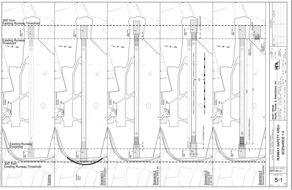
1 CHAPTER 5 Runway/Taxiway Alternatives 5.1 INTRODUCTION This chapter presents the development and analysis of different layouts and configurations of both Runway and its related taxiways. A primary objective in these analyses is to enhance safety margins at the Block Island Airport. Given that Block Island is a well-known and attractive environment, it is extremely popular with aviation day-trippers from the New York and Coastal New England areas. As noted by the pilot members and airport management members of the Technical Advisory Committee, these day-trippers exhibit a wide range of pilot skill levels. Accordingly, it is desirable that the physical configuration and dimensions of the airport infrastructure, i.e., runway, taxiways, apron, taxilanes, striping, markings, the surrounding navigable airspace and so on, be designed and built to FAA design standards to the greatest extant practicable. In the analyses presented herein, RIAC attempts to maximize the limited BID airfield areas while providing acceptable levels of safety, economy and durability. In several instances, these attempts yield solutions that fall short of FAA design standards. In these cases, RIAC managers will work closely with FAA staff to arrive at solutions acceptable to all. RIAC 5.2 WORKING ASSUMPTIONS The following assumptions form the bases of the various concepts and scenarios presented in this chapter: Runway length. The present Runway length of 2, 501 feet will remain for the duration of the study period. Runway width. Although the present runway width of 100 feet exceeds the FAA design standards by 25 feet, it is assumed that the 100-foot width will remain for the duration of the study period. Arguments for the 100-foot width include the following: i) Runway is the only runway at BID and thus must be used in all weather and wind conditions and directions; ii) The airport is popular with operators and pilots of smaller GA aircraft and the skill levels of these pilots range from beginner to highly skilled; iii) The island and the airport are enveloped frequently by sea mist and fog, making a centerline landing very difficult at best; and 5-1

2 Runway/Taxiway Alternatives iv) Such a scenario (maintaining a width wider than required by FAA design standards for various reasons) has precedent in the FAA New England Region, i.e., Pittsfield (ME), Danbury (CT) [Runways 8-26 and 17-35], to name two. Britten-Norman Islander. The (STOL) B-N Islander 10-seat aircraft is still in production with the final assembly done on the Isle of Wight off the southern coast of England. While the financial underpinnings of the Britten-Norman company have been hit-or-miss in the recent past, the B-N Group (BNG), a company owned by members of the Zawawi family from the Sultanate of Oman, now exercises ownership. The Islander aircraft and its derivatives remain very popular: more than 1,250 aircraft have been delivered to customers in some 120 countries. Accordingly, it is assumed that the Islander will remain in commercial service and will serve as the design aircraft throughout the planning period. Airport Master Plan ARC of A-II. The existing Airport Reference Code (ARC) of BID A-II will remain through the planning period. The ARC is based, presumably, on the Britten-Norman Islander aircraft in commercial passenger service at BID. The Islander is listed as having a wingspan of 49 feet 0 inches, just making it into the Airplane Design Group (ADG) II category. 1,2 The airport surfaces and dimensions associated with BID and an ARC of A-II are tabulated in Table 2-6. The existing ARC of A-II is based on the number of operations in the B-N Islander, an A-II aircraft. In 2001, the last year for which these data exists, airline operations accounted for 8,081 of the total operations of 17,755, or 46 percent of the total. While New England Airlines does downsize to a smaller single-engine aircraft when passenger loads are low, the overwhelming majority of airline operations occur in the B-N Islander aircraft. 5.3 RUNWAY SAFETY AREA SCENARIOS The present runway asphalt surface and its underlying structural base are at the end of their engineering useful life. Accordingly, a full-scale rehabilitation of the runway is envisioned within the next two years. While BID is not a Part 139 airport and thus is not required by FAA regulations to enhance its present runway safety areas, RIAC management is taking such a step voluntarily. Safety is of primary importance both to FAA and RIAC. As depicted in Figures 5-1 and 5-2, seven (7) scenarios are considered in this master plan. Several alternatives or scenarios address the issue of the substandard runway safety area (RSA) off the approach end to Runway 10. At approximately 158 feet in the length, the existing RSA is 142 feet short of the FAA standard of 300 feet for an ARC of A-II (for runways with not lower than ¾-statute mile approach visibility minimums). The RSA off the approach end to Runway 28, built in the early 1990 s, meets FAA standards for a 150-foot-wide-by-300-foot-long RSA. 1 Airplanes are grouped based on wingspan. Group I: wingspans up to but not including 49 feet. Group II: wingspans 49 feet up to but not including 79 feet. 2 The Britten-Norman Group was contacted and confirmed the listed wingspan of the Islander aircraft. 5-2

3
4

5 Runway/Taxiway Alternatives BLOCK ISLAND AIRPORT Given the present airport boundaries and the location of Center Road west of Runway 10-28, the maximum runway safety area that can be obtained off the Runway 10 approach end is /- feet. This assumes a 50-foot-wide public right-of-way for Center Road and a vertical structural wall to support the RSA located on a 10-foot offset from the ROW. The wall is estimated at 10 feet in height and is intended to retain the additional fill required off the end of Runway 10 to construct an RSA to FAA-specified grades. A Build to Standard option is presented in Figure 5-1 as Scenario 1. This scenario depicts a standard 300-foot-long RSA built off the Runway 10 end, which requires a realignment of Center Road well to the west of its existing location. This realignment would be very difficult due to the fact that the topography drops off sharply in this area, requiring considerable fill. In addition, construction of the RSA itself would require considerable fill given the grade change beyond approximately 158 feet from the existing Runway 10 threshold. A series of detailed engineering plans compiled in Appendix F gives additional detail on the grading and fill requirements for this scenario. A runway shift to the east is depicted in Scenario 2 (Figure 5-1). This scenario maintains the existing alignment of the runway but shifts both runway thresholds 105 feet to the east. The runway length remains at 2,501 feet. While this scenario avoids impacts to the airport maintained as habitat for the Northern Blazing Star (south of the runway at the Runway 28 approach end), the RSA still would intrude into wetlands located east of the airport, if fill were to be used. Alternatively, a foot vertical structural wall could be constructed 300 feet from the runway threshold. In this instance, a structural wall referred to as a reinforced earth wall is proposed. Unlike a standard retaining wall which utilizes the bulk and strength of the wall itself to retain the earth mass behind it, a reinforced earth wall utilizes concrete panels tied to strips buried in the retained earth mass for its strength and rigidity (see illustration below). The advantages of such a wall include relatively easy on-site assembly of precast concrete panels constructed off-site and the ability to weave a variety of textures and colors into the precast concrete panels, among others. Cross-section of a Typical Reinforced Earth Wall RIAC 5-7

6 Runway/Taxiway Alternatives Scenario 3 presents a runway alignment showing two shifts one a shift of 130 feet to the east and a second shift of 100 feet to the south. The runway length remains at 2,501 feet. This scenario: Avoids disrupting Center Road by utilizing airport property to the east of Runway 28; Expands the width of aircraft parking on the terminal side by 100 feet; and Decreases somewhat the difficulty in constructing a full parallel taxiway to the Runway 28 end. There are a number of serious drawbacks to this scenario, however.: 1. At the Runway 10 end, the realigned runway intrudes into an area that is currently managed for Northern Blazing Star, a state endangered plant species. If fill alone was to be used at the 28 end to construct the RSA, the resultant grades required to maintain a stable slope would shift the toe of slope into wetlands to the east and south of the Runway 28 approach end. Airport Master Plan 2. Significant quantities of fill would be required to construct this scenario. 3. The wind cone and VOR now fall within the Runway Object Free Area (ROFA) and would have to be relocated outside the ROFA. The VOR is an FAA facility and given RIAC s interest in reconstructing Runway in the near future, it is unlikely that the VOR could be relocated in the near term, assuming FAA would be interested in moving the VOR at all. 4. The RIAC-owned MALSF would have to be realigned to match the realigned runway centerline. Such a shift could be accommodated within the present airport boundaries. RIAC managers note that the present MALSF is prone to problems and breakdowns and is nearing its useful life; a replacement system is planned for the near future. Such planning would have to be accelerated to coincide with the runway realignment. Scenario 4 in Figure 5-1 introduces the concept of declared distances at BID. The net effect of this scenario is to reduce the Landing Distance Available (LDA) for landings on both runway ends. Given that the runway is considered short by many pilots now, it is not recommended that any scenario that shortens the runway further be pursued. Scenarios 5-7 in Figure 5-2 illustrate a series of alternatives that keep the runway along its present bearing but shift the runway to one end or the other. These shifts fall within a corridor approximately 3,041 feet long, formed by the available land between the existing Runway 10 threshold and the Center Road ROW (240 feet), the length of the runway (2,501 feet) and the graded runway safety area off the approach end of Runway 28 (300 feet). Scenario 5 maintains the standard RSA on the 26 end, Scenario 6 places the standard RSA on the Runway 10 approach end and Scenario 7 essentially splits the difference, assigning 270 feet of RSA off both runway ends. Several pilot members of the Technical Advisory Committee and the BID airport manager provided valuable insight to BID operations at TAC Meeting #4 held October 21, Both favored Scenario 6 for the following reasons: 1. Runway 28 has a much higher runway end use than Runway 10, particularly in the summer months. 2. Anecdotal evidence indicates that overshoots rather than the undershoots are the more prevalent of the two. 5-8

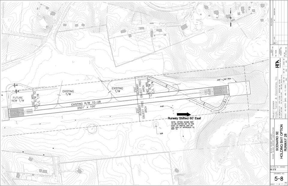
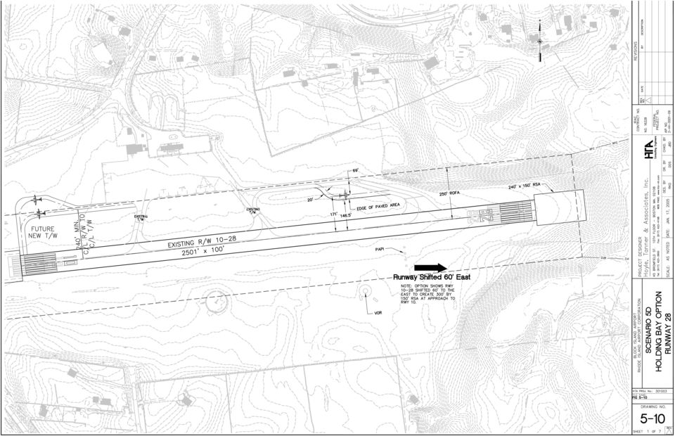
7 Runway/Taxiway Alternatives BLOCK ISLAND AIRPORT 3. Transient operations occur primarily in the summer when a Runway 28 landing is the preferred approach to BID. Subject to further discussion with FAA representatives, RIAC managers have selected Scenario 6 as the preferred runway alternative, given that it balances the need to enhance safety margins with an avoidance of impacts to the wetlands located off the Runway 28 approach end. Figures 5-3 through 5-5 provide additional details on the preferred runway alternative. 5.4 TAXIWAY SCENARIOS Runway 10 Figure 5-6 indicates Build to Standard taxiway configurations to the Runway 10 end with holding bays in both scenarios. Option 1 in Figure 5-6 depicts the holding bay with a taxiway-to-taxilane separation distance of 105 feet (FAA AC 150/ Airport Design, Table 2-3). Option 2 in Figure 5-6 uses the equations in the notes below Table 2-3 in AC 150/ Airport Design to modify standard dimension listed in Table 2-3 (which is based on a maximum wingspan in ADG II: 79 feet). Given that i) BID is an A-II airport operating at the lower extremes of ADG II (49-foot wingspans vs. 79-foot wingspans), and that ii) minimizing the size of the holding bay maximizes the area available for aircraft parking to the north of the holding, Option 2 is the preferred alternative. RIAC managers will work with FAA staff to ensure this options meets all FAA safety requirements for holding bays Runway 28 RIAC Figure 5-7 depicts a Build to Standard taxiway to the Runway 28 end at the required runway-totaxiway clearance standard of 240 feet. The close contour lines in the figure indicate the steepness of the grades in this area and the rapid drop off from the runway. This configuration would require large amounts of fill or a lengthy, costly retaining wall. Impacts to wetlands are inherent in this configuration. While preferred from an operations standpoint, both RIAC and FAA managers and technical staff felt compelled to move off this configuration at an early stage in the master plan. Accordingly, the Build to Standard taxiway option to the Runway 28 will be dropped from further consideration. Figures 5-8 through 5-11 represent a series of taxiway alternatives intended to provide some operational flexibility to pilots taxiing to/from Runway 28. The pilot representatives at TAC Meeting #4 noted the desirability of some means to bypass an airplane along Taxiway Charlie. The pilots noted a specific instance where a pilot flying an IFR route may be required to hold along the taxiway, thus delaying all other aircraft behind, even those who could take-off under VFR conditions. A bypass taxiway, a holding bay or some such means offering an alternative path to the Runway 28 end. The four options depicted in Figures 5-8 through 5-11 fall into three groupings as follows: 5-9

8 Runway/Taxiway Alternatives Group [Scenarios] Taxiway south of Rwy [Scenario 5E] Taxiway/holding bay south of Rwy [Scenario 5F] Taxiway or holding bay north of Rwy [Scenarios 5D-1, 5G-1] Notes This option entails a rwy crossing to move aircraft to a new twy south of the rwy. The angled twy to the Rwy 28 end is intended to lessen the need for a retaining wall, given the steep drop-off immediately south of the Rwy 28 threshold. Once Aircraft A is on the new twy, aircraft behind Aircraft A would be able to move onto the rwy and backtaxi to the rwy end for takeoff. Hold lines are positioned at 125 feet from the rwy centerline. This option, which also entails a rwy crossing, would eliminate backtaxiing to the Rwy 28 end by constructing a partial parallel twy south of the rwy. The twy would be configured with a holding bay allowing for bypass taxi movements. The simplest solution, constructing a stub taxiway (5G-1), would allow aircraft to move onto the runway west of the existing intersection of Twy Charlie and the rwy. However, backtaxiing distances would increase, from 560 feet at present to 842 feet, an increase of 50 percent. Scenario 5D-1 presents an in-line holding bay between the parallel twy and the rwy. The holding bay centerline is located approx. 171 feet from the rwy centerline. Airport Master Plan There are several other considerations worth noting with these four scenarios: 1. Proximity to PAPI system. As configured at present, Scenario 5F passes in close proximity to the existing PAPI s south of Rwy FAA AC 150/ D Precision Approach Path Indicator (PAPI) Systems states that the inboard light unit shall be no closer than 50 feet, +10, -0 from the runway edge or to other runways or taxiways. Along with considerations of Taxiway Safety Areas and the like, either the new taxiway would have to be realigned and reconfigured or the PAPI s themselves relocated, which triggers its own set of issues, i.e., aiming along the designated visual glide path and so on. 2. Proximity to VOR. Some options pass closer to the VOR than others. While the scenarios do not propose parking aircraft in the VOR vicinity, several do call for aircraft to hold there. FAA technical staff will be consulted as to whether any of the scenarios trigger concerns about the operational reliability of the VOR. 3. Grade south of Runway 28 threshold. The grade drops off steeply just south of the Runway 28 threshold. Study team designers attempted to place the taxiway at an angle in some scenarios to avoid/minimize the need for a retaining wall. Final design on the selected scenario can explore this in further detail but when the Taxiway Safety Area is figured in as well, it s likely that some length of retaining wall will be necessary if the preferred alternative comes from certain designs. The preferred alternative is Scenario 5D-1 (Figure 5-10). This scenario does not entail a runway crossing and thus reduces the risk of runway incursions. It does, however, provide a holding area for run-ups and for aircraft awaiting IFR clearance. RIAC managers will work closely with FAA staff to ensure this option conforms to FAA safety requirements for holding bays. 5-10

9

10

11

12

13 Runway/Taxiway Alternatives This page left blank intentionally. Airport Master Plan 5-18

14

15
16

17
18

19 Runway/Taxiway Alternatives BLOCK ISLAND AIRPORT 5.5 EMERGENCY ACCESS Given the space constraints of the airport, obstruction clearance requirements and distances from surrounding features required by non-precision and precision approaches to an on-airport heliport, it was determined, in consultation with RIAC and FAA representatives, that the existing RNAV approaches (see Appendix C) to both runways and the approach lighting system to Runway 10 allowed reasonably good access to the airport in periods of inclement weather. Therefore, no additional measures to improve emergency access to the airport via helicopter are proposed. RIAC 5-25
 to both runways and the approach lighting system to Runway 10 allowed reasonably good access to the airport in periods of inclement")
20 Runway/Taxiway Alternatives This page left blank intentionally. Airport Master Plan 5-26

Los Angeles International Airport North Airfield Assessment
 Appendix H-3 LAX SPECIFIC PLAN AMENDMENT STUDY REPORT Los Angeles International Airport North Airfield Assessment May 2007 Prepared for: Los Angeles World Airports One World Way Los Angeles, California
Departures to the south from Runways 16L and 16R.
 Mode 5 Method of operation Departures to the south from Runways 16L and 16R. Arrivals from the east on Runway 25. Arrivals from the north for those aircraft requiring to use the long runway. This runway
Appendix E FAA ALP Sheet Checklist
 Appendix E FAA ALP Sheet Checklist AC 150/5070-6B (incl. Chg. 1, 5/1/07) Airport Layout Plan Drawing Set The following list provides general guidelines in preparing the Airport Layout Plan set. The individual
3.1 Aerodrome information to be provided for a certified aerodrome
 CHAPTER 3:AERODROME DATA 3.1 Aerodrome information to be provided for a certified aerodrome 3.1.1 Aerodrome chart. An aerodrome chart will contain the following information: a) layout of runways, taxiways
CHAPTER 7. AIRSPACE 7.1 AFFECTED ENVIRONMENT
 CHAPTER 7. AIRSPACE 7.1 AFFECTED ENVIRONMENT 7.1.1 Definition of Resource Airspace management is defined as directing, controlling, and handling flight operations in the volume of air that overlies the
TP 308 IMPACT STUDY TORONTO BILLY BISHOP/TORONTO CITY AIRPORT. for
 TP 308 IMPACT STUDY TORONTO BILLY BISHOP/TORONTO CITY AIRPORT for May, 2013 TABLE OF CONTENTS Report TAB 1 Map1: Runway 08-26 Extension TAB 2 Maps 2 & 3: Runway 08-26 Obstacle Assessment TAB 3 Canada Air
3.0 FACILITY REQUIREMENTS
 3.0 FACILITY REQUIREMENTS This chapter identifies the facility requirements necessary to meet existing and forecast airport requirements, satisfy FAA design standards, and improve safety. The facility
AIRCRAFT NOISE ABATEMENT OPERATING PROCEDURES AND RESTRICTIONS
 AIRCRAFT NOISE ABATEMENT OPERATING PROCEDURES AND RESTRICTIONS This section sets forth the Los Angeles World Airports (LAWA s) informal noise abatement traffic; flight and runway use procedures and includes
CHAPTER 3 ALTERNATIVES CONSIDERED
 3.0 INTRODUCTION CHAPTER 3 ALTERNATIVES CONSIDERED The existing Afton Airport parallel taxiway, with its approximate 4,360 foot length, only accommodates one half of the runway s length, and is too short
EGTR ELSTREE EGTR AD 2.1 AERODROME LOCATION INDICATOR AND NAME EGTR AD 2.2 AERODROME GEOGRAPHICAL AND ADMINISTRATIVE DATA
 UNITED KINGDOM AIP AD 2.EGTR-1 8 Jan 2015 EGTR ELSTREE EGTR AD 2.1 AERODROME LOCATION INDICATOR AND NAME EGTR ELSTREE EGTR AD 2.2 AERODROME GEOGRAPHICAL AND ADMINISTRATIVE DATA 1 ARP coordinates and site
CHAPTER 8: VISUAL AIDS PROVIDED BY AERODROME MARKINGS, MARKERS, SIGNALS AND SIGNS. Section 8.1: General
 CHAPTER 8: VISUAL AIDS PROVIDED BY AERODROME MARKINGS, MARKERS, SIGNALS AND SIGNS Section 8.1: General 8.1.1 Introduction 8.1.1.1 This Chapter specifies the standards for Markers, Markings, Signals and
Mary C. Frederick, RCE PMP Division Chief. Caltrans Division of Aeronautics 1
 Mary C. Frederick, RCE PMP Division Chief Caltrans Division of Aeronautics 1 Aeronautics Mission Assist in the development and preservation of a safe and environmentally compatible air transportation system
Plan of Construction Operations (PCO)
") REQUEST FOR PROPOSAL APPENDIX G Plan of Construction Operations 13 006 A Taxi A Expansionn CLIENT: TradePort International Corporation, Operators of John C. Munro Hamilton International Airport (YHM) April
REQUEST FOR PROPOSAL APPENDIX G Plan of Construction Operations 13 006 A Taxi A Expansionn CLIENT: TradePort International Corporation, Operators of John C. Munro Hamilton International Airport (YHM) April
Area Navigation (RNAV)/Wide Area Augmentation System (WAAS) Instrument Approach Procedures (IAP s) and the New Charting Format.
/Wide Area Augmentation System (WAAS) Instrument Approach Procedures (IAP s) and the New Charting Format.") PURPOSE. Area Navigation (RNAV)/Wide Area Augmentation System (WAAS) Instrument Approach Procedures (IAP s) and the New Charting Format. [REVISED 1/5/00] Instrument procedures in the first half of the
PURPOSE. Area Navigation (RNAV)/Wide Area Augmentation System (WAAS) Instrument Approach Procedures (IAP s) and the New Charting Format. [REVISED 1/5/00] Instrument procedures in the first half of the
Background on Airspace
 Background on Airspace There are six classifications of airspace in the United States; A, B, C, D, E, and G. Class A is the most restrictive and Class G the least restrictive. They can be categorized as:
(3) CATEGORY III means a permanent heliport facility. (4) COMMISSION means the City of Austin Airport Advisory Commission.
 CATEGORY III means a permanent heliport facility. (4) COMMISSION means the City of Austin Airport Advisory Commission.") 13-1-171 DEFINITIONS. (A) Terms not otherwise defined in this article have the meaning prescribed by applicable aviation law, including Federal Aviation Administration Advisory Circular 150/5390-2A (Heliport
13-1-171 DEFINITIONS. (A) Terms not otherwise defined in this article have the meaning prescribed by applicable aviation law, including Federal Aviation Administration Advisory Circular 150/5390-2A (Heliport
WHICH AIR TRAFFIC CONTROLLER TO CONTACT
 WHICH AIR TRAFFIC CONTROLLER TO CONTACT 1. Introduction This article is written in order to explain to all beginners in the IVAO network the basics for any pilot to contact the correct air traffic controller.
3 Tappan Zee Bridge Rehabilitation Options
 3 Tappan Zee Bridge Rehabilitation Options 3.1 Introduction This chapter describes possible options that rehabilitate and enhance the existing Tappan Zee Bridge. Four Rehabilitation Options have been developed:
1: PURPOSE AND NEED 1-1 1.1 INTRODUCTION 1-1 1.2 PURPOSE OF THIS ENVIRONMENTAL ASSESSMENT 1-1 1.3 PROPOSED ACTION 1-4 1.
 Table of Contents TABLE OF CONTENTS for a New Runway at Ridgeland Airport Chapter and Section Page CHAPTER 1: PURPOSE AND NEED 1-1 1.1 INTRODUCTION 1-1 1.2 PURPOSE OF THIS ENVIRONMENTAL ASSESSMENT 1-1
USE OF A DIGITAL SURVEY VEHICLE FOR PAVEMENT CONDITION SURVEYS AT AIRPORTS. Paul W. Wilke, P.E. Applied Research Associates, Inc.
 USE OF A DIGITAL SURVEY VEHICLE FOR PAVEMENT CONDITION SURVEYS AT AIRPORTS Paul W. Wilke, P.E. Applied Research Associates, Inc. August 11, 2014 Words: 3,280 Figures: 3 Tables: 0 Photographs: 3 ABSTRACT
10 Aviation Element. 10.1 Introduction. 10.1.1 Purpose of Chapter
 10 Aviation Element 10.1 Introduction 10.1.1 Purpose of Chapter This chapter provides the aviation element of the RFATS 2035 Long Range Transportation Plan. It describes the existing conditions and trends
Aircraft Noise Control at London Luton Airport. August 2015
 Aircraft Noise Control at London Luton Airport August 2015 Aircraft Noise Control at London Luton Airport Foreword London Luton Airport (LLA) continues to place aircraft noise high on its agenda. We recognise
Road Rehabilitation and Reconstruction Using AutoCAD Civil 3D
 Road Rehabilitation and Reconstruction Using AutoCAD Civil 3D Contents Introduction... 3 Introduction to Corridor Targets... 3 Surface Targets... 4 Width and Offset Targets... 5 Elevation or Slope Targets...
AN AIRCRAFT TAXI SIMULATION MODEL FOR THE UNITED PARCEL SERVICE LOUISVILLE AIR PARK. W. Swain Ottman Angela C. Ford Gregory R.
 Proceedings of the 1999 Winter Simulation Conference P. A. Farrington, H. B. Nembhard, D. T. Sturrock, and G. W. Evans, eds. AN AIRCRAFT TAXI SIMULATION MODEL FOR THE UNITED PARCEL SERVICE LOUISVILLE AIR
Air Medical Transport Planning Good planning can save lives. Planning for air medical transport
 Chapter 1 2 15 Air Medical Transport Planning Good planning can save lives. Planning for air medical transport is important to maximize efficiency and safety; it helps create the best care for patients.
ILS Replacement. ACI World Safety Seminar. 18 19 November 2008 Kempinski Hotel Beijing Lufthansa Centre
 ILS Replacement Xiaosong Xiao, PhD Tetra Tech, Inc. Orlando, USA Contents: Ground-Based Navigation ILS Approach GNSS/SBAS Approach Comparisons between ILS and GNSS Example: Cost Analysis Between LAAS and
The total estimated PFC revenue for the application is $266,900,000. The estimated charge effective date for this application is December 1, 2016.
 Public Notice of Application for Authority to Impose and Use Passenger Facility Charges (PFCs) at EWR, LGA, JFK and SWF and Amendment to Approved PFC Applications at EWR, LGA, and JFK The Port Authority
LOCAL OPERATING PROCEDURES (LOP) LANDVETTER TWR (ESGG)
 LANDVETTER TWR (ESGG)") 2011 LOCAL OPERATING PROCEDURES (LOP) LANDVETTER TWR (ESGG) Göteborg/Landvetter ESGG ESGG_TWR 118.600 / ESGG_GND 121.900 / ESGG_DEL 121.675 (VATSIM 121.670) Landvetter Tower / Landvetter Ground / Clearance
2011 LOCAL OPERATING PROCEDURES (LOP) LANDVETTER TWR (ESGG) Göteborg/Landvetter ESGG ESGG_TWR 118.600 / ESGG_GND 121.900 / ESGG_DEL 121.675 (VATSIM 121.670) Landvetter Tower / Landvetter Ground / Clearance
WATSONVILLE MUNICIPAL AIRPORT MASTER PLAN CITY OF WATSONVILLE, SANTA CRUZ COUNTY, CALIFORNIA CHAPTER 3. AVIATION FORECASTS REVISED APRIL 2010
 WATSONVILLE MUNICIPAL AIRPORT MASTER PLAN CITY OF WATSONVILLE, SANTA CRUZ COUNTY, CALIFORNIA CHAPTER 3. AVIATION FORECASTS REVISED APRIL 2010 TABLE OF CONTENTS WATSONVILLE MUNICIPAL AIRPORT MASTER PLAN
Page 2 of 7 SPKT FIGURE CHANGES
 Page 1 of 7 Gleim Sport Pilot FAA Knowledge Test 2014 Edition, 1st Printing Updates February 8, 2014 The FAA has released a new Computer Testing Supplement. The FAA made every effort to keep the figures
AIRCRAFT WARNING LIGHTS
 AIRCRAFT WARNING LIGHTS Ing. Pierangelo Lodolo, ing. Giuseppe Menta Calzavara S.p.a 1. Summary are lighting devices used to make tall structures more visible to aircrafts, during both daytime and nighttime.
OPERATIONS CIRCULAR. OC NO 2 OF 2014 Date: 1 st May 2014. Continuous Descent Final Approach (CDFA) 1. PURPOSE
 1. PURPOSE") GOVERNMENT OF INDIA CIVIL AVIATION DEPARTMENT DIRECTOR GENERAL OF CIVIL AVIATION OC NO 2 OF 2014 Date: 1 st May 2014 OPERATIONS CIRCULAR Subject: Continuous Descent Final Approach (CDFA) 1. PURPOSE This
GOVERNMENT OF INDIA CIVIL AVIATION DEPARTMENT DIRECTOR GENERAL OF CIVIL AVIATION OC NO 2 OF 2014 Date: 1 st May 2014 OPERATIONS CIRCULAR Subject: Continuous Descent Final Approach (CDFA) 1. PURPOSE This
Michael Harrison Aviation Management Associates Alternative PNT Public Meeting Stanford University August 10-11. Federal Aviation Administration
 Michael Harrison Aviation Management Associates Alternative PNT Public Meeting Stanford University Suspending Current Belief Current practices for air traffic control, procedures and separation will not
Instrument Pilot Rating Course (ASEL) Training Syllabus FAR Part 61
 Training Syllabus FAR Part 61") Instrument Pilot Rating Course (ASEL) Training Syllabus FAR Part 61 Property of Tech Aviation Flight School. Reproduction of this manual in full or part is strictly prohibited by law. Distribution or use
Instrument Pilot Rating Course (ASEL) Training Syllabus FAR Part 61 Property of Tech Aviation Flight School. Reproduction of this manual in full or part is strictly prohibited by law. Distribution or use
CAAP 89W-1(0) Guidelines on provision of obstacle information for take-off flight planning purposes
 Guidelines on provision of obstacle information for take-off flight planning purposes") Civil Aviation Advisory Publication This publication is only advisory. It gives the preferred method for complying with the Civil Aviation Regulations (CAR 1988). It is not the only method, but experience
Civil Aviation Advisory Publication This publication is only advisory. It gives the preferred method for complying with the Civil Aviation Regulations (CAR 1988). It is not the only method, but experience
3.1 Historical Considerations
 3. Recommended Scope of Bridge improvements 3.1 Historical Considerations In the fall of 2000, an outside consultant, Fraser Design, suggested that the existing 4 th St. Bridge is potentially eligible
3. FLYING TECHNIQUES. 3.1 Speed Management. 3.2 Attitude Management. 3.3 Height Management. 3.4 Transit Flying
 3. FLYING TECHNIQUES 3.1 Speed Management Maintaining an appropriate airspeed can be very challenging in mountainous terrain. Pilots need to be aware of the speed limitations from the RFM especially in
H is for HELP! He was employed as an EMS pilot in Buffalo New York for about 2 years, than transferred to work as a relief pilot through out WI.
 H is for HELP! Wind Turbines and EMS helicopters in Wisconsin This interview with retired EMS pilot Ray Slavik, was submitted to the Calumet County Ad Hoc Committee researching proposed ordinances governing
Hospital Heliport Inspection Basics
 Hospital Heliport Inspection Basics Eric Peltier Aviation Representative Office of Aeronautics 222 E Plato Blvd St. Paul, MN 55107 651 234 7184 [email protected] Sources FAA AC 150/5390 2C Heliport
How To Know The History Of The Airport
 Pekin Municipal Airport (C1) John C. Kriegsman Air Field: Fact Sheet General aviation airport included in the National Plan of Integrated Airport Systems (NPIAS) Federally funded at an estimated $6,81,412
Título ponencia: Helicopter IFP. Point-in-Space (PinS)
") Título ponencia: Helicopter IFP. Point-in-Space (PinS) Organizado por: Index Introduction Helicopter IFP A/C Certification requirements GNSS Certified rotorcrafts Most relevant projects in Europe Introduction
Título ponencia: Helicopter IFP. Point-in-Space (PinS) Organizado por: Index Introduction Helicopter IFP A/C Certification requirements GNSS Certified rotorcrafts Most relevant projects in Europe Introduction
Part 135. Air Operations Helicopters and Small Aeroplanes. CAA Consolidation. 24 September 2015
 Part 135 CAA Consolidation 24 September 2015 Air Operations Helicopters and Small Aeroplanes Published by the Civil Aviation Authority of New Zealand DESCRIPTION Part 135 prescribes the operating requirements
Seagull Intersection Layout. Island Point Road - A Case Study. Authors: John Harper, Wal Smart, Michael de Roos
 Seagull Intersection Layout. Island Point Road - A Case Study Authors: John Harper, Wal Smart, Michael de Roos Presented by Mr John Harper, Road Safety and Traffic Services Manager Phone: 4221 2456 Mobile:
Florida Building Code 2004 SECTION 1009 STAIRWAYS AND HANDRAILS
 Florida Building Code 2004 SECTION 1009 STAIRWAYS AND HANDRAILS 1009.1 Stairway width. The width of stairways shall be determined as specified in Section 1005.1, but such width shall not be less than 44
AIRSPACE EXPLAINED. Separation of Traffic
 AIRSPACE EXPLAINED Airspace is an area of aeronautical knowledge that is commonly poorly demonstrated on airman practical tests. Even when airman applicants demonstrate knowledge of the airspace system
12.0 SAFETY AND SECURITY
 12.0 SAFETY AND SECURITY 12.0 SAFETY AND SECURITY Key points The development plan within this Master Plan: Will improve airfield safety by reducing the towed aircraft runway crossings and other airfield
Air Support services are centred on four core practice areas, as indicated below and briefly described later on.
 Mission Statement Air Support is an aviation engineering and consulting company operating in the Italian, European, Africa end South America markets. Air Support is specialized in providing key aviation
Current and Forecast Demand
 Existing Facilities A new terminal opened in September 2005 at the Southwest Florida International Airport (RSW), replacing the 17-gate original terminal that opened in 1983. The $438 million Midfield
Pilot Briefing Stockholm/Arlanda
 Pilot Briefing Stockholm/Arlanda INTRODUCTION Thank you for taking time to read the briefing for Stockholm/Arlanda Airport. The purpose of this document is not to teach pilots basic procedures and how
Flight Operations Briefing Notes
 Flight Operations Briefing Notes I Introduction Encountering wake turbulence in flight can be a surprising experience, both for crews and passengers. Wake turbulence occurs suddenly, and is usually accompanied
Airspace. Chapter 14. Introduction
 Chapter 14 Airspace Introduction The two categories of airspace are: regulatory and nonregulatory. Within these two categories there are four types: controlled, uncontrolled, special use, and other airspace.
Safe & Sound Bridge Terminology
 Safe & Sound Bridge Terminology Abutment A retaining wall supporting the ends of a bridge, and, in general, retaining or supporting the approach embankment. Approach The part of the bridge that carries
Providing Flight Training at:
 Providing Flight Training at: The G. O. Carlson / Chester County Airport Business Route 30, in Valley Township 1 Earhart Drive, Suite 4, Coatesville, PA 19320 610-384-9005 www.chestercountyaviation.com
Minimum Safety Requirements for temporary Helicopter Landing Areas.
 GOVERNMENT OF INDIA OFFICE OF DIRECTOR GENERAL OF CIVIL AVIATION TECHNICAL CENTRE, OPP SAFDARJANG AIRPORT, NEW DELHI CIVIL AVIATION REQUIREMENTS SECTION 4 - AERODROME STANDARDS & AIR TRAFFIC SERVICES SERIES
CHAPTER 4. HOSPITAL HELIPORTS
 AC 150/5390-2B September 30, 2004 CHAPTER 4. HOSPITAL HELIPORTS 400. GENERAL. Helicopters have proven to be an effective means of transporting injured persons from the scene of an accident to a hospital
Airport Charges and Handling Fees. AIRPORT DEBRECEN Kft.
 Airport Charges and Handling Fees AIRPORT DEBRECEN Kft. Valid between 01 MAY, 2014 and 30 SEPTEMBER, 2014 Approved by Mr Tamás Sápi, Managing Director OLDAL: 1 / 22 LIST OF MODIFICATIONS Line number of
AIRCRAFT PERFORMANCE Pressure Altitude And Density Altitude
 Performance- Page 67 AIRCRAFT PERFORMANCE Pressure Altitude And Density Altitude Pressure altitude is indicated altitude corrected for nonstandard pressure. It is determined by setting 29.92 in the altimeter
Advisory Circular Updates Airport Planning and Environmental Division (APP-400)
") Advisory Circular Updates Airport Planning and Environmental Division (APP-400) Danielle J. Rinsler, AICP Kent Duffy FAA Office of Airports December 11, 2013 Advisory Circular Update Context As of 2012,
Advisory Circular Updates Airport Planning and Environmental Division (APP-400) Danielle J. Rinsler, AICP Kent Duffy FAA Office of Airports December 11, 2013 Advisory Circular Update Context As of 2012,
and Implementing Rules for Air Operations of Community Operators F. Cross Reference Tables
 European Aviation Safety Agency 30 Jan 2009 NOTICE OF PROPOSED AMENDMENT (NPA) NO 2009 02F DRAFT OPINIONS OF THE EUROPEAN AVIATION SAFETY AGENCY, FOR A COMMISSION REGULATION establishing the implementing
Radio Communications in Class D Airspace by Russell Still, Master CFI
 Radio Communications in Class D Airspace by Russell Still, Master CFI Class D airspace is one of the most common parts of the airspace system that requires specific radio communications. Although you can
> Current Operations & Business Context. Bankstown Airport Master Plan 2004/05. Bankstown Airport / Master Plan > 29
 Bankstown Airport Master Plan 2004/05 Bankstown Airport / Master Plan > 29 8.1 Bankstown Airport s Role in the Sydney Basin Bankstown Airport is the premier GA airport in NSW. In addition to servicing
Benefits of Preventative Maintenance Pavement Sealers
 Pavement Coatings Technology Council WWW.PAVEMENTCOUNCIL.ORG Benefits of Preventative Maintenance Pavement Sealers Introduction Pavement Sealers have been used successfully for around 60 years. Recently,
ICAO Safety Management Systems (SMS) Course Handout N 5 Cuzco International Airport operation
 Course Handout N 5 Cuzco International Airport operation") ICAO Safety Management Systems (SMS) Course Handout N 5 Cuzco International Airport operation International Civil Aviation Organization Page left blank intentionally ICAO Safety management systems (SMS)
ICAO Safety Management Systems (SMS) Course Handout N 5 Cuzco International Airport operation International Civil Aviation Organization Page left blank intentionally ICAO Safety management systems (SMS)
GHANA CIVIL AVIATION AUTHORITY EVALUATING AERONAUTICAL EFFECTS OF PROPOSED CONSTRUCTION ON AIR NAVIGATION & AIRSPACE PERMIT PROCEDURE
 GHANA CIVIL AVIATION AUTHORITY EVALUATING AERONAUTICAL EFFECTS OF PROPOSED CONSTRUCTION ON AIR NAVIGATION & AIRSPACE PERMIT PROCEDURE TABLE OF CONTENTS 1.0 INTRODUCTION 2.0 LEGISLATION AND REGULATORY FRAMEWORK
The Mayor of London s Submission:
 Inner Thames Estuary Feasibility Study Response to Airports Commission Call for Evidence The Mayor of London s Submission: Supporting technical documents 23 May 2014 Title: Runway utilisation Author: Atkins
AIRFIELD DRIVING TEST
 AIRFIELD DRIVING TEST NAME: COMPANY: DATE: SCORE: 1. Runway incursions are primarily caused by the following errors, except a. Pilot/ground vehicle/controller communication errors b. Lack of airport familiarity
OPERATING MINIMA FOR AEROPLANES AND HELICOPTER OPERATIONS PURPOSE REFERENCE 4.0 DEFINITION
 ORDER TCAA-O-OPS034A March 2013 OPERATING MINIMA FOR AEROPLANES AND HELICOPTER OPERATIONS PURPOSE 1. This Order gives guidance to the Authority s Operations Inspector on the procedures for approval of
SECTION 5 DRAFTING STANDARDS
 SECTION 5 DRAFTING STANDARDS 1 SECTION FIVE TABLE OF CONTENTS Description Page TABLE OF CONTENTS... 5-2 GENERAL... 5-3 DRAFTING STANDARDS... 5-5 DRAFTING MINIMUM REQUIREMENTS HANDOUT... 5-8 2 GENERAL 1.
4 EXISTING AND FORECAST NOISE EXPOSURE MAPS
 Updated 14 C.F.R. Part 150 Noise Exposure Maps page 53 4 EXISTING AND FORECAST NOISE EXPOSURE MAPS 4.1 Introduction As discussed in Section 1.3.1, the most fundamental elements of the NEMs submission are
AIR TRAFFIC INITIAL ENVIRONMENTAL REVIEW
 AIR TRAFFIC INITIAL ENVIRONMENTAL REVIEW Operational Test Period #2 to Evaluate the Feasibility of Changing Runway Configurations at Two Times during the Day at Boston-Logan Airport FAA Order 7400.2 Appendix
UK AIRSPACE Introduction
 UK AIRSPACE Introduction The UK has now adopted the ICAO system for naming of airspace types from A to G. However in the UK there is at present no Class C airspace. Classes A to E are called Controlled
The purpose of this meeting is to inform the public of the updates to the project, and to get input before the finalization of the project.
 The purpose of this meeting is inform the public of the updates the project, and get input before the finalization of the project. The following panels describe the purpose and hisry of the project, along
8-1 Chapter 8 Radio Operations: Aviation Spoken Here
 8-1 Chapter 8 Radio Operations: Aviation Spoken Here Radio Technique 1. [8-2/1/1] Using the radio is no great mystery. When transmitting, hold the radio close to your. A. mouth B. ear C. tongue VHF Transmitions
SYSTEM GLOBAL NAVIGATION SATELLITE SYSTEM LANDING TECHNOLOGY/PRODUCT DEVELOPMENT
 GLOBAL NAVIGATION SATELLITE SYSTEM LANDING SYSTEM The aviation industry is developing a new positioning and landing system based on the Global Navigation Satellite System (GNSS). The GNSS landing system
AD 2-LGML-1 GREECE 12 NOV 2015 LGML AD 2.1 AERODROME LOCATION INDICATOR AND NAME LGML - MILOS
 AD 2-LGML-1 GREECE 12 NOV 2015 LGML AD 2.1 AERODROME LOCATION INDICATOR AND NAME LGML - MILOS LGML AD 2.2 AERODROME GEOGRAPHICAL AND ADMINISTRATIVE DATA 1 ARP coordinates and site at AD 364149N 0242837E
Takeoff Tools TM Crosswind Calculator Instructions Copyright 2005 by Eric C. King. All rights reserved. Rev. 11Sep05. How to Use
 Takeoff Tools TM Crosswind Calculator Instructions Copyright 2005 by Eric C. King. All rights reserved. Rev. 11Sep05 Takeoff Tools TM Suppose you re arriving at, or about to depart from, an airport. You
Chapter 3: Weather Map. Weather Maps. The Station Model. Weather Map on 7/7/2005 4/29/2011
 Chapter 3: Weather Map Weather Maps Many variables are needed to described weather conditions. Local weathers are affected by weather pattern. We need to see all the numbers describing weathers at many
MASTER PLAN PREPARATION
 Located in the East Valley of the Phoenix Metropolitan Area, Phoenix-Mesa Gateway Airport is a former military airfield that has successfully made the transition to a full service commercial passenger
ADA POST INSPECTION CHECKLIST. Job No. Route County Location
 ADA POST INSPECTION CHECKLIST Job No. Route County Location SIDEWALKS All sidewalks constructed within the project limits are ADA compliant. Sidewalks are 5 or greater in width. Exception, existing sidewalks
Pilot Professionalism It Isn t Just For The Big Guys
 Pilot Professionalism It Isn t Just For The Big Guys Earl F Weener Board Member American Bonanza Society Convention & Trade Show Buffalo, NY September 25, 2010 Pilot Professionalism - NTSB Interest Lack
U.S. DEPARTMENT OF TRANSPORTATION FEDERAL AVIATION ADMINISTRATION. National Policy. SUBJ: OpSpec A021, Helicopter Air Ambulance (HAA) Operations
 Operations") NOTICE U.S. DEPARTMENT OF TRANSPORTATION FEDERAL AVIATION ADMINISTRATION National Policy N 8900.A021 Effective Date: XX/XX/XX Cancellation Date: XX/XX/XX SUBJ: OpSpec A021, Helicopter Air Ambulance (HAA)
NOTICE U.S. DEPARTMENT OF TRANSPORTATION FEDERAL AVIATION ADMINISTRATION National Policy N 8900.A021 Effective Date: XX/XX/XX Cancellation Date: XX/XX/XX SUBJ: OpSpec A021, Helicopter Air Ambulance (HAA)
Verizon SMARTS Data Center Design Phase 1 Conceptual Study Report Ms. Leah Zabarenko Verizon Business 2606A Carsins Run Road Aberdeen, MD 21001
 Verizon SMARTS Data Center Design Phase 1 Conceptual Study Report Ms. Leah Zabarenko Verizon Business 2606A Carsins Run Road Aberdeen, MD 21001 Presented by: Liberty Engineering, LLP 1609 Connecticut Avenue
The checklist utilized by the Authority will be similar to that which is shown below. Project Name: Location: Consulting Engineering Firm:
 Page 1 of 6 Section 1. PURPOSE This policy is an Engineering checklist of the Local Review Program for sanitary sewer improvement projects by the Bedford Regional Water Authority ( Authority ). Section
Tauranga, Bay of Plenty
 19/12 720 NZZC Tauranga Aerodrome Airshow and Restricted Area NZR286 Effective: 28 to 29 JAN 12 PORTAVEX 2012 and CLAIC OF THE KY will be held at Tauranga AD during the period 27 to 29 JAN 12. This event
GEOMETRIC DESIGN CIVL 3161
 GEOMETRIC DESIGN CIVL 3161 Reading Assignment: p. 45-72 (4 th ed.) p.45-75 (previous ed.) in Mannering textbook. Geometric design of highway facilities deals with the proportion of physical elements of
Providing Flight Training at:
 Providing Flight Training at: The G. O. Carlson / Chester County Airport Business Route 30, in Valley Township 1 Earhart Drive, Suite 4, Coatesville, PA 19320 610-384-9000 www.chestercountyaviation.com
Chapter 3 SENSITIVE AREAS AND VEGETATED CORRIDORS
 Chapter 3 3.01 General Provisions 3.01.1 Introduction 3.01.2 Application and Interpretation of Chapter 3.01.3 Unbuildable Lots 3.01.4 Other Permits 3.01.5 Prohibited Activities 3.02 Service Provider Letter
Multi-Engine Training And The PTS
 Multi-Engine Training And The PTS GHAFI John Sollinger/Larry Hendrickson October 28, 2000 Overview FAR differences between original and add-on Multi-Engine PTS Training methods Common training scenarios
Chapter 3: Weather Map. Station Model and Weather Maps Pressure as a Vertical Coordinate Constant Pressure Maps Cross Sections
 Chapter 3: Weather Map Station Model and Weather Maps Pressure as a Vertical Coordinate Constant Pressure Maps Cross Sections Weather Maps Many variables are needed to described dweather conditions. Local
LONDON SOUTHEND AIRPORT CLASS D CONTROLLED AIRSPACE GUIDE
 CLASS D CONTROLLED AIRSPACE GUIDE Introduction From the 2 nd of April 2015 London Southend Airport (LSA) will be implementing Class D (CAS). This airspace is made up of a Control Zone (CTR) and Control
Cumulative Diagrams: An Example
 Cumulative Diagrams: An Example Consider Figure 1 in which the functions (t) and (t) denote, respectively, the demand rate and the service rate (or capacity ) over time at the runway system of an airport
SEWER LINE EXTENSION DESIGN CHECKLIST
 SEWER LINE EXTENSION DESIGN CHECKLIST SWLE# Utilities Staff Date DISCLAIMER - This checklist is provided to Consulting Engineers for the express purpose of assisting them in compiling design plans for
FLORIDA STATE COLLEGE AT JACKSONVILLE COLLEGE CREDIT COURSE OUTLINE
 Form 2A, Page 1 FLORIDA STATE COLLEGE AT JACKSONVILLE COLLEGE CREDIT COURSE OUTLINE COURSE NUMBER: ATF 2305 COURSE TITLE: Instrument Flight PREREQUISITE(S): ATF 1101 or ATF 1109 COREQUISITE(S): STUDENT