Legal Description of Unit A
|
|
|
- Homer McDonald
- 8 years ago
- Views:
Transcription
1 Legal Description of Unit A All bearings are true mean bearings, as orientated to North American 1927 Datum (NAD 27), as determined from the National Geodetic Reference System, unless otherwise noted. Located within protracted sections 14, 15, & 22, T. 27 S., R. 59 E., C.R.M. W1/2 W1/2 SW1/4 of Section 14 lying easterly of the Ordinary High Water Line (OHWL) of the left bank of the Taiya River; SE1/4 of Section 15 easterly of the OHWL of the left bank of the Taiya River; Section 22 North of the South 1/16 line, easterly of the easterly Right of Way (ROW) of Dyea Road, and easterly of the OHWL of the left bank of the Taiya River; Unit A is more particularly described as follows: Commencing at the witness point for corner 28, Tract B, ASLS monumented with an aluminum post 2-1/2 ins. in diameter with an 3-1/4 aluminum cap, as described on the plat of ASLS and in the notes of U.S. Survey No ; thence South, 2.64 feet (0.04 chains) to the true point for corner 28, Tract B, ASLS 97-61, not monumented; this point also being the intersection of the eastern ROW of Dyea Road with the South 1/16 line of section 22, T. 27 S., R. 59 E., C.R.M. and the True Point of Beginning for this Unit: Thence S E., feet (9.46 chains) on the South 1/16 line, common to the Administrative Boundary of the Klondike Gold Rush National Historic Park to the true point for corner 10, U.S. Survey No identical to corner 29, Tract B, ASLS and also identical to the South 1/16 section corner of Sections 22 and 23, T. 27 S., R. 59 E., C.R.M., not monumented. From this point the witness corner to the South 1/16 section corner of Sections 22 and 23, T. 27 S., R. 59 E., C.R.M., bears S E., 7.00 feet (0.106 chains) monumented with a brass tablet 2 ins. in diam. as described on the plat of ASLS and in the notes of U.S. Survey No ; Thence N W., 3, feet (60.00 chains) on the section line between sections 22 and 23, T. 27 S., R. 59 E., C.R.M., common to the Administrative Boundary of the Klondike Gold Rush National Historic Park to the true point for Corner 11, U.S. Survey No , identical with the corner of Sections 14, 15, 22, and 23, T. 27 S., R. 59 E., C.R.M., monumented with a stainless steel post 2-1/2 ins. in diam., with a 3-1/4 ins brass cap as described in the field notes of U.S. Survey No ; Thence East, feet (9.80 chains) on the section line between sections 14 and 23, T. 27 S., R. 59 E., C.R.M., common to the Administrative Boundary of the Klondike Gold Rush National Historic Park to the witness corner to Corner 12, U.S. Survey No , monumented with a stainless steel post 2-1/2 ins. in diam., with a 3-1/4 ins brass cap as described in the field notes of U.S. Survey No ; Thence East, feet (0.20 chains) continuing on the section line between sections 14 and 23, T. 27 S., R. 59 E., C.R.M., common to the Administrative Boundary of the Klondike Gold Rush National Historic Park to the true point for Corner 12, U.S. Survey No , identical with the West-West 1/64 corner of Sections 14 and 23, T. 27 S., R. 59 E., C.R.M., not monumented; Thence N W., 2, feet (40.00 chains) on the West-West 1/64 section line of section 14, T. 27 S., R. 59 E., C.R.M., common to the Administrative Boundary of the Klondike Gold Rush National Historic Park to the true point for Corner 13, U.S. Survey No , identical with the Center-West-West 1/64 corner of Section 14, T. 27 S., R. 59 E., C.R.M., monumented with a stainless steel post 2-1/2 ins. in diam., with a 3-1/4 ins brass cap as described in the field notes of U.S. Survey No ; Thence West, approximately 1,058 feet, on the protracted East-West center lines of Sections 14 and 15, T. 27 S., R. 59 E., C.R.M., to the OHWL of the left bank of the Taiya River, not monumented; Thence southerly, approximately 7,090 feet along the OHWL of the left bank of the Taiya River, in sections 14, 15, and 22, T. 27 S., R. 59 E., C.R.M., to the Page 2 of 12
 of Dyea Road, and easterly of the OHWL of the left bank of the Taiya River; Unit A is more particularly described")
2 intersection of the OHWL of the left bank of the Taiya River with the eastern ROW of Dyea Road, which is a line 50 feet easterly and parallel with the existing center line of Dyea Road, not monumented. Thence southerly, approximately 739 feet on the eastern ROW of Dyea Road, which is feet easterly of the center line of Dyea Road, to the True Point of Beginning. Excluding the feet wide Dyea Road ROW, feet each side of the center line, not surveyed along this Unit. This Unit has an approximate area of 72 Acres, as extrapolated from the attached Exhibit A-1. Page 3 of 12

3 Legal Description of Unit B All bearings are true mean bearings, as orientated to North American 1927 Datum (NAD 27), as determined from the National Geodetic Reference System, unless otherwise noted. Located within protracted section 22, T. 27 S., R. 59 E., C.R.M. Section 22 North of the South 1/16 line, westerly of the westerly Right of Way (ROW) of Dyea Road, and easterly of the Ordinary High Water Line (OHWL) of the left bank of the Taiya River; Unit B is more particularly described as follows: Commencing at corner 9, U.S. Survey No , not monumented, falls with in the Taiya River, thence S E., feet (1.00 chains) on the South 1/16 line, Section 22, T. 27 S., R. 59 E., C.R.M., common to the Administrative Boundary of the Klondike Gold Rush National Historic Park, to a witness point on line 9-10, monumented with a stainless steel post 2-1/2 ins. in diam., with a 3-1/4 ins brass cap as described in the field notes of U.S. Survey No , and the True Point of Beginning for this Unit; Thence S E., feet (8.07 chains) on the South 1/16 line, common to the Administrative Boundary of the Klondike Gold Rush National Historic Park to the intersection with the western ROW of Dyea Road, not monumented. Said western ROW line is feet westerly of and parallel with line C-27 C-28, Tract B, ASLS Thence northerly, approximately 674 feet along the western ROW of Dyea Road, which is feet easterly of the existing center line of Dyea Road, to the intersection with the OHWL of the left bank of the Taiya River, not monumented; Thence southwesterly, approximately 890 feet along the OHWL of the left bank of the Taiya River, in section 22, T. 27 S., R. 59 E., C.R.M., to the intersection of the OHWL of the left bank of the Taiya River with the South 1/16 line, Section 22, T. 27 S., R. 59 E., C.R.M., not monumented. Thence S E., approximately feet (0.90 chain) on the South 1/16 line, common to the Administrative Boundary of the Klondike Gold Rush National Historic Park and line 9-10 U.S. Survey No , to the True Point of Beginning. Excluding the feet wide Dyea Road ROW, feet each side of the center line, not surveyed along this Unit. This Unit has an approximate area of 5 Acres, as extrapolated from the attached Exhibit A-2. Page 4 of 12

4 Legal Description of Unit C All bearings are true mean bearings, as orientated to North American 1927 Datum (NAD 27), as determined from the National Geodetic Reference System, unless otherwise noted. Located within protracted sections 22 & 27, T. 27 S., R. 59 E., C.R.M. Section 22 South of the South 1/16 line, westerly of the westerly Right of Way (ROW) of Dyea Road, easterly of the Ordinary High Water Line (OHWL) of the left bank of the Taiya River, and excluding Lots 1C & 1D, U.S. Survey No. 1249; Section 27 westerly of the westerly ROW of Dyea Road and easterly of the OHWL of the left bank of the Taiya River; Unit C is divided into two (2) Lots. Lot C1 is that portion of Unit C within the Administrative Boundary of the Klondike Gold Rush National Historic Park and Lot C2 is that portion of Unit C outside of the Administrative Boundary of the Klondike Gold Rush National Historic Park more particularly described as follows: Lot C1, Unit C Commencing at corner 9, U.S. Survey No , not monumented, falls with in the Taiya River, thence S E., feet (2.00 chains) on the East 1/16 line, Section 22, T. 27 S., R. 59 E., C.R.M., common to the Administrative Boundary of the Klondike Gold Rush National Historic Park, to a witness point on line 8-9, monumented with a stainless steel post 2-1/2 ins. in diam., with a 3-1/4 ins brass cap as described in the field notes of U.S. Survey No , and the True Point of Beginning for this Lot; Thence S E., 1, feet (20.82 chains) on the East 1/16 line, common to the Administrative Boundary of the Klondike Gold Rush National Historic Park, to a witness point on line 8-9, monumented with a stainless steel post 2-1/2 ins. in diam., with a 3-1/4 ins brass cap as described in the field notes of U.S. Survey No ; Thence continuing S E., approximately feet (2.63 chains) on the East 1/16 line, common to the Administrative Boundary of the Klondike Gold Rush National Historic Park, to the intersection of the East 1/16 line with the OHWL of the left bank of the Taiya River, not monumented; Thence northwesterly to northeasterly, approximately 1,874 feet along the OHWL of the left bank of the Taiya River, in sections 22 and 27, T. 27 S., R. 59 E., C.R.M., to the southern meander corner of Lot 1D, U.S. Survey No. 1249, not monumented; Thence N E., approximately feet (0.88 chain) to the witness corner to a meander corner for Lot 1D, U.S. Survey No. 1249, monumented with a stainless steel post 2-1/2 ins. in diam., with a 3-1/4 ins brass cap as described in the field notes of U.S. Survey No. 1249; Thence N E., feet (3.15 chains) to the angle point for Lots 1C and 1D, U.S. Survey No. 1249, monumented with a stainless steel post 2-1/2 ins. in diam., with a 3-1/4 ins brass cap as described in the field notes of U.S. Survey No. 1249; Thence North, feet (2.02 chains) to the witness corner to the meander corner for Lot 1C, U.S. Survey No. 1249, monumented with a stainless steel post 2-1/2 ins. in diam., with a 3-1/4 ins brass cap as described in the field notes of U.S. Survey No. 1249; Thence North, approximately feet (0.37 chain) to the OHWL of the left bank of the Taiya River, not monumented; Thence northeasterly, approximately 252 feet along the OHWL of the left bank of the Taiya River, in section 22, T. 27 S., R. 59 E., C.R.M., to the intersection of the OHWL of the left bank of the Taiya River with the East 1/16 line, Section 22, T. 27 S., R. 59 E., C.R.M., not monumented; Thence S E., approximately feet on the East 1/16 line, common to the Administrative Boundary of the Klondike Gold Rush National Historic Park, to the True Point of Beginning. Page 5 of 12
 Lots.")
5 Lot C2, Unit C Commencing at corner 9, U.S. Survey No , not monumented, falls with in the Taiya River, thence S E., feet (2.00 chains) on the East 1/16 line, Section 22, T. 27 S., R. 59 E., C.R.M., common to the Administrative Boundary of the Klondike Gold Rush National Historic Park, to a witness point on line 8-9, monumented with a stainless steel post 2-1/2 ins. in diam., with a 3-1/4 ins brass cap as described in the field notes of U.S. Survey No , and the True Point of Beginning for this Lot; Thence S E., 1, feet (20.82 chains) on the East 1/16 line, common to the Administrative Boundary of the Klondike Gold Rush National Historic Park, to a witness point on line 8-9, monumented with a stainless steel post 2-1/2 ins. in diam., with a 3-1/4 ins brass cap as described in the field notes of U.S. Survey No ; Thence continuing S E., approximately feet (2.63 chains) on the East 1/16 line, common to the Administrative Boundary of the Klondike Gold Rush National Historic Park, to the intersection of the East 1/16 line with the OHWL of the left bank of the Taiya River, not monumented; Thence southeasterly, approximately 660 feet along the OHWL of the left bank of the Taiya River, in section 27, T. 27 S., R. 59 E., C.R.M., to the intersection of the OHWL of the left bank of the Taiya River with the western ROW of Dyea Road, not monumented. Said western ROW line is feet westerly of and parallel with the center line of Dyea Road ROW as depicted on ASLS 97-61; Thence northerly approximately 388 feet on said western ROW of Dyea Road, to point on the western ROW of Dyea Road, not monumented, from which corner 2, U.S. Survey No bears N E., feet, monumented with a 3-1/4 ins. brass tablet (2 feet below the surface of the road); Thence N E., approximately, 667 feet on the western ROW of Dyea Road, to a point not monumented. ROW is parallel and feet westerly of the center line of Dyea Road. Said center line is common with line 2-3, U.S. Survey No. 3414; Thence N E., approximately, 875 feet on the western ROW of Dyea Road, to the intersection with the South 1/16 line of in section 22, T. 27 S., R. 59 E., C.R.M., not monumented. ROW is parallel and feet westerly of the eastern ROW of Dyea Road common with line C-27 to C-28, ASLS 97-61; Thence N W., feet (8.07 chains) on the South 1/16 line of section 22, T. 27 S., R. 59 E., C.R.M.,, common to the Administrative Boundary of the Klondike Gold Rush National Historic Park to to a witness point on line 9-10, monumented with a stainless steel post 2-1/2 ins. in diam., with a 3-1/4 ins brass cap as described in the field notes of U.S. Survey No ; Thence N W., approximately feet (0.90 chain) on the South 1/16 line of section 22, T. 27 S., R. 59 E., C.R.M.,, common to the Administrative Boundary of the Klondike Gold Rush National Historic Park and line 9-10 U.S. Survey No , to the intersection of the South 1/16 line with the OHWL of the left bank of the Taiya River, not monumented. Thence southwesterly, approximately 12 feet along the OHWL of the left bank of the Taiya River, in section 22, T. 27 S., R. 59 E., C.R.M., to the intersection of the OHWL of the left bank of the Taiya River with the the East 1/16 line, Section 22, T. 27 S., R. 59 E., C.R.M., not monumented; Thence S E., approximately feet on the East 1/16 line, common to the Administrative Boundary of the Klondike Gold Rush National Historic Park, to the True Point of Beginning. Excluding the feet wide Dyea Road ROW, feet each side of the center line, the center line and/or the ROW has been surveyed along this Unit. Page 6 of 12
 on the East 1/16 line, common to the Administrative Boundary of the Klondike Gold Rush National Historic Park, to a witness point on line 8-9, monumented with a stainless steel post 2-1/2")
6 This Unit has an approximate area of 40 Acres, with Lot C1 having an approximate area of 19 Acres and Lot C2 having an approximate area of 21 Acres, as extrapolated from the attached Exhibit A-2. Page 7 of 12

7 Legal Description of Unit D All bearings are true mean bearings, as orientated to North American 1927 Datum (NAD 27), as determined from the National Geodetic Reference System, unless otherwise noted. Located within section 35, T. 26 S., R. 59 E., C.R.M. Lands lying west of U.S. Survey No and 685 feet south of the prolongation of line 5-6 of U.S. Survey No and easterly of the Ordinary High Water Line (OHWL) of the left bank of the Taiya River; Unit D is more particularly described as follows: Commencing at the point for corner 6, U.S. Survey No monumented with an iron post 2-1/2 ins. in diameter with a 3-1/4 brass cap, as described on the plat and in the field notes of U.S. Survey No The True Point of Beginning for this Unit: Thence South, feet (10.38 chains) on line 6-7, U.S. Survey No. 5108, to a point, not monumented. From this point corner 7, U.S. Survey No monumented with a brass tablet 3-1/4 ins. diam., in a drill hole, as described on the plat and in the field notes of U.S. Survey No bears South, 1, feet (19.62 chains); Thence Due West, approximately 1,048 feet to the OHWL of the left bank of the Taiya River, not monumented; Thence northeasterly, approximately 1,110 feet along the OHWL of the left bank of the Taiya River, in section 35, T. 26 S., R. 59 E., C.R.M., to the intersection of the OHWL of the left bank of the Taiya River with a line bearing True West from for corner 6, U.S. Survey No. 5108, not monumented; Thence East, approximately 206 feet to corner 6, U.S. Survey No. 5108, and the True Point of Beginning. This Unit has an approximate area of 10 Acres, as extrapolated from the attached Exhibit A-3. Page 8 of 12
 of the left bank of the Taiya River; Unit D is more particularly described as follows: Commencing at the point for corner 6, U.S. Survey No.")
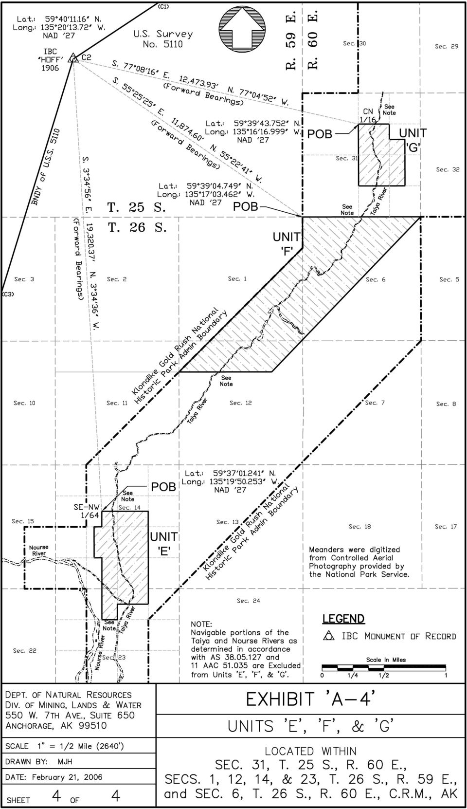
8 Legal Description of Unit E Protracted positions, are as derived from the State of Alaska Protraction Diagram C.R , approved by the State of Alaska September 22, 1961 and revised with the addition of U.S. Survey No May 22, All bearings are true mean bearings, as orientated to North American 1927 Datum (NAD 27), as determined from the National Geodetic Reference System, unless otherwise noted. Located within protracted Sections 14 & 23, T. 26 S., R. 59 E., C.R.M. The S½SW¼NE¼, SE¼SE¼NW¼, NW¼SE¼, SW¼SE¼, E½NE¼SW¼, E½W½NE¼SW¼, and E½SE¼SW¼ of Section 14; The N½NW¼NE¼ and E½NE¼NW¼ of Section 23; All excluding the beds of the navigable portions of the Taiya and Nourse Rivers as Unit E is more particularly described as follows: Commencing at corner 2, (original) U.S. Survey No. 5110, identical with International Boundary Commission triangulation station HOFF 1906, monumented with a ¾ in. copper bolt, the position of HOFF 1906, as published by the International Boundary Commission and as platted on the plat of the original U.S. Survey No. 5110, is: Lat N., Long W. Monument as described in the field notes of U.S. Survey No. 5110; Thence S E. (Forward Bearing), 19, feet to the protracted position for the Southeast-Northwest 1/64 corner of Section 14, T 26 S., R. 59 E., C.R.M., at: Lat N., Long W. The True Point of Beginning for this Unit, not monumented; Thence S E, feet (10.00 chains) on the protracted East-West 1/64 line of Section 14, T. 26 S., R. 59 E., C.R.M. to the protracted position for the Center-East-West 1/64 corner of Section 14, T. 26 S., R. 59 E., C.R.M., not monumented; Thence West, feet (5.00 chains) on the protracted East-West center line of Section 14, T. 26 S., R. 59 E., C.R.M. to the protracted position for the Center-West-East-West 1/256 corner of Section 14, T. 26 S., R. 59 E., C.R.M., not monumented; Thence S E, 1, feet (20.00 chains) on the protracted West-East- West 1/256 line of Section 14, T. 26 S., R. 59 E., C.R.M. to the protracted position for the Center-West-East-Southwest 1/256 corner of Section 14, T. 26 S., R. 59 E., C.R.M., not monumented; Thence East, feet (5.00 chains) on the protracted South 1/16 line of Section 14, T. 26 S., R. 59 E., C.R.M. to the protracted position for the Center- East-Southwest 1/64 corner of Section 14, T. 26 S., R. 59 E., C.R.M., not monumented; Thence S E, 2, feet (40.00 chains) on the protracted East-West 1/64 lines of Sections 14 and 23, T. 26 S., R. 59 E., C.R.M. to the protracted position for the Center-West-Northeast 1/64 corner of Section 23, T. 26 S., R. 59 E., C.R.M., not monumented; Thence East, feet (10.00 chains) on the protracted North 1/16 line of Section 23, T. 26 S., R. 59 E., C.R.M. to the protracted position for the Center- North 1/16 corner of Section 23, T. 26 S., R. 59 E., C.R.M., not monumented Thence N W, feet (10.00 chains) on the protracted North- South center line of Section 23, T. 26 S., R. 59 E., C.R.M. to the protracted position for the Center-North-North 1/64 corner of Section 23, T. 26 S., R. 59 E., C.R.M., not monumented; Thence East, feet (20.00 chains) on the protracted North-North 1/64 line of Section 23, T. 26 S., R. 59 E., C.R.M. to the protracted position for Page 9 of 12

9 the Center- North-Northeast 1/64 corner of Section 23, T. 26 S., R. 59 E., C.R.M., not monumented; Thence N W, feet (60.00 chains) on the protracted East 1/16 line of Sections 14 and 23, T. 26 S., R. 59 E., C.R.M. to the protracted position for the Center-South-Northeast 1/64 corner of Section 14, T. 26 S., R. 59 E., C.R.M., not monumented; Thence West, feet (30.00 chains) on the protracted South-North 1/64 line of Section 14, T. 26 S., R. 59 E., C.R.M., to the point for the Southeast-Northwest 1/64 corner of Section 14, T 26 S., R. 59 E., C.R.M., and the True Point of Beginning for this Unit. All excluding the beds of the navigable portions of the Taiya and Nourse Rivers as This Unit has an approximate area of 200 Acres as extrapolated from the attached Exhibit A-4. Page 10 of 12

10 Legal Description of Unit F Protracted positions, are as derived from the State of Alaska Protraction Diagram C.R , approved by the State of Alaska September 22, 1961 and revised with the addition of U.S. Survey No May 22, All bearings are true mean bearings, as orientated to North American 1927 Datum (NAD 27), as determined from the National Geodetic Reference System, unless otherwise noted. Located within protracted Sections 1 & 12, T. 26 S., R. 59 E., Section 6, T. 26 S., R. 60 E., C.R.M. Unit F is more particularly described as follows: Commencing at corner 2, (original) U.S. Survey No. 5110, identical with International Boundary Commission triangulation station HOFF 1906, monumented with a ¾ in. copper bolt, the position of HOFF 1906, as published by the International Boundary Commission and as platted on the plat of the original U.S. Survey No. 5110, is: Lat N., Long W. Monument as described in the field notes of U.S. Survey No Thence S E. (Forward Bearing), 11, feet to the protracted position for the corner of Townships 25 & 26 South, Ranges 59 & 60 East, C.R.M., at: Lat N., Long W. The True Point of Beginning for this Unit, not monumented: Thence South, 1, feet (20.00 chains) on the protracted township line between Ts. 26 S., Rs. 59 & 60 E., C.R.M. common to the Administrative Boundary of the Klondike Gold Rush National Historic Park to the protracted position for the North 1/16 corner of Section 1, T. 26 S., R. 59 E., and Section 6, T. 26 S., R. 60 E., C.R.M., not monumented; Thence S W., 7, feet ( chains) on the Administrative Boundary of the Klondike Gold Rush National Historic Park to the intersection with the protracted North 1/16 line of Section 12, intersection not monumented; Thence East, 3, feet (59.99 chains) on the protracted North 1/16 line of Section 12, T. 26 S., R. 59 E., C.R.M. to the protracted position for the Northeast 1/16 corner of Section 12, T. 26 S., R. 59 E., C.R.M., not monumented; Thence N E., 9, feet ( chains) to the protracted position for the corner of Sections 31 & 22, T. 25 S., R. 59 E., and Sections 5 & 6, T. 26 S., R. 59 E., C.R.M., not monumented; Thence West, 5, feet (76.32 chains) on the township line between Section 31, T. 25 S., R. 59 E., and Section 6, T. 26 S., R. 59 E., C.R.M. to the True Point of Beginning. This Unit has an approximate area of 602 Acres, as extrapolated from the attached Exhibit A-4. Page 11 of 12
 U.S. Survey No.")
11 Legal Description of Unit G Protracted positions, are as derived from the State of Alaska Protraction Diagram C.R , approved by the State of Alaska September 22, 1961 and revised with the addition of U.S. Survey No May 22, All bearings are true mean bearings, as orientated to North American 1927 Datum (NAD 27), as determined from the National Geodetic Reference System, unless otherwise noted. Located within protracted Section 31, T. 25 S., R. 60 E., C.R.M. The SW¼SE¼NE¼, SW¼NE¼, W½NE¼SE¼, and NW¼SE¼, of Section 31; Unit G is more particularly described as follows: Commencing at corner 2, (original) U.S. Survey No. 5110, identical with International Boundary Commission triangulation station HOFF 1906, monumented with a ¾ in. copper bolt, the position of HOFF 1906, as published by the International Boundary Commission and as platted on the plat of the original U.S. Survey No. 5110, is: Lat N., Long W. Monument as described in the field notes of U.S. Survey No. 5110; Thence S E. (Forward Bearing), 12, feet to the protracted position for the Center-North 1/16 corner of Section 31, T 25 S., R. 60 E., C.R.M., at: Lat N., Long W. The True Point of Beginning for this Unit, not monumented; Thence S E, 2, feet (40.00 chains) on the protracted North- South center line of Section 31, T. 25 S., R. 60 E., C.R.M. to the protracted position for the Center-South 1/16 corner of Section 31, T. 25 S., R. 60 E., C.R.M., not monumented; Thence East, 1, feet (30.00 chains) on the protracted South 1/16 line of Section 31, T. 25 S., R. 60 E., C.R.M. to the protracted position for the Center-East-Southeast 1/64 corner of Section 31, T. 25 S., R. 60 E., C.R.M., not monumented; Thence N W, 1, feet (30.00 chains) on the protracted East-East 1/64 line of Section 31, T. 25 S., R. 60 E., C.R.M. to the protracted position for the Southeast-Northeast 1/64 corner of Section 31, T. 25 S., R. 60 E., C.R.M., not monumented; Thence West, feet (10.00 chains) on the protracted South-North 1/64 line of Section 31, T. 25 S., R. 60 E., C.R.M. to the protracted position for the Center-South-Northeast 1/64 corner of Section 31, T. 25 S., R. 60 E., C.R.M., not monumented; Thence N W, feet (10.00 chains) on the protracted East 1/16 line of Section 31, T. 25 S., R. 60 E., C.R.M. to the protracted position for the Northeast 1/16 corner of Section 31, T. 25 S., R. 60 E., C.R.M., not monumented Thence West, 1, feet (20.00 chains) on the protracted North 1/16 line of Section 31, T. 25 S., R. 60 E., C.R.M. to the True Point of Beginning. This Unit has an approximate area of 110 Acres, as extrapolated from the attached Exhibit A-4. Page 12 of 12

12

13

14

15
Modern Real Estate Practice in Illinois, 6 th Edition Filmore W. Galaty, Wellington J. Allaway, Robert C. Kyle Laurie MacDougal, Consulting Editor
 Filmore W. Galaty, Wellington J. Allaway, Robert C. Kyle Laurie MacDougal, Consulting Editor Chapter 9 Review Quiz 1. The numbering of sections in a township begins in the section in the a. northeast corner
Chapter 9 Questions Legal Descriptions
 Chapter 9 Questions Legal Descriptions 1. How many acres are in a lot that is 1/4 of a mile wide by 1/4 of a mile long? a. 10 b. 120 c. 40 d. 80 2. The numbering of sections in a township begins in the
First American Title Insurance Company. National Commercial Services
 Page Number: 1 National Commercial Services 1850 Mt. Diablo Blvd., Suite 300 Walnut Creek, CA 94596 Lawrence Dunnigan Port Of Oakland 530 Water Street Oakland, CA 94607 Phone: (510)627-1100 Escrow Officer:
CHAPTER 4 LEGAL DESCRIPTION OF LAND DESCRIBING LAND METHODS OF DESCRIBING REAL ESTATE
 r CHAPTER 4 LEGAL DESCRIPTION OF LAND DESCRIBING LAND A legal description is a detailed way of describing a parcel of land for documents such as deeds and mortgages that will be accepted in a court of
U.S. PUBLIC LAND SURVEY SYSTEM
 UNIT 12 U.S. PUBLIC LAND SURVEY SYSTEM Jim McCavitt, PLS Bureau of Land Management Introduction The United States Public Land Survey System (PLSS) began with the Land Ordinance of 1785. The ordinance provided
CHAPTER 8 - LAND DESCRIPTIONS
 CHAPTER 8 - LAND DESCRIPTIONS Notes: While the location of land is commonly referred to by street number and city, it is necessary to use the legal description in the preparation of those instruments relating
Basic Rectangular Surveys
 Basic Rectangular Surveys The Public Land Survey System What Are We Going To Talk About? The rectangular survey system How it is designed How the surveys were supposed to be performed Some unique aspects
BERMUDA MARITIME SECURITY (HARBOUR AREAS) (RESTRICTED ZONES) ORDER 2010 BR 79 / 2010
 (RESTRICTED ZONES) ORDER 2010 BR 79 / 2010") QUO FA T A F U E R N T BERMUDA MARITIME SECURITY (HARBOUR AREAS) (RESTRICTED ZONES) ORDER BR 79 / The Governor, in exercise of the powers conferred by section 12 of the Maritime Security Act 1997, makes
QUO FA T A F U E R N T BERMUDA MARITIME SECURITY (HARBOUR AREAS) (RESTRICTED ZONES) ORDER BR 79 / The Governor, in exercise of the powers conferred by section 12 of the Maritime Security Act 1997, makes
STATE OF ALASKA DEPARTMENT OF NATURAL RESOURCES DIVISION OF MINING, LAND AND WATER. GENERAL SURVEY INSTRUCTIONS EASEMENTS Authority 11 AAC 53
 STATE OF ALASKA DEPARTMENT OF NATURAL RESOURCES DIVISION OF MINING, LAND AND WATER GENERAL SURVEY INSTRUCTIONS EASEMENTS Authority 11 AAC 53 These instructions define the survey and platting criteria unique
ORDINANCE NO. AN ORDINANCE
 150201 (Published ) #R/W-2015-4 ORDINANCE NO. AN ORDINANCE vacating TRACT 1 - All that part of the Southwest Quarter of Section 6, Township 11 South, Range 24 East, and all that part of vacated Lots 19,
 Exhibit 1 Legal Description of the Property PARCEL A Girard Description. (Parcel A) Beginning at a point on the northern side of Lanier Avenue and the corner of the Point Breeze Parcel B-3 North 58 52'39"
FORMULA FOR FINDING THE SQUARE FEET OF A RECTANGLE L x W = A
 UNIT I REAL ESTATE MATH AREA MEASUREMENTS FORMULA FOR FINDING THE SQUARE FEET OF A RECTANGLE L x W = A Where: A = Area L = Length W = Width If the length = 30 and the width = 20 20 x 30 = 600 Sq. Feet
Chapter 7: Land Descriptions
 Chapter 7: Land Descriptions 7. Land Descriptions An * in the left margin indicates a change in the statute, rule or text since the last publication of the manual. I. Introduction While the location of
Public Notice for Waiver of Aeronautical Land-Use Assurance. Indianapolis International Airport, Indianapolis, Indiana.
 This document is scheduled to be published in the Federal Register on 02/19/2015 and available online at http://federalregister.gov/a/2015-03485, and on FDsys.gov [4910-13] DEPARTMENT OF TRANSPORTATION
Tax Parcel Mapping. Visual Representations of Legal Descriptions and So Much More
 Tax Parcel Mapping Visual Representations of Legal Descriptions and So Much More Topics I. E-Distribution II. GIS & Tax Mapping III. Tax Mapping Procedures IV. Deeds, Property Descriptions, & You! I. E-Distribution
H. R. 5486. To reaffirm that certain land has been taken into trust for the benefit of the Poarch Band of Creek Indians, and for other purposes.
 I 114TH CONGRESS 2D SESSION H. R. 5486 To reaffirm that certain land has been taken into trust for the benefit of the Poarch Band of Creek Indians, and for other purposes. IN THE HOUSE OF REPRESENTATIVES
PART VI: BOUNDARY SURVEYING
 PART VI: BOUNDARY SURVEYING 6.1 The U.S. Rectangular Survey System (Overview) The Public Land Survey System in Michigan is referenced to two axes. The North and South axis is the Michigan Principal Meridian
Legal Descriptions. Chapter 9
 Legal Descriptions Chapter 9 Legal Description Defined A description of land is legally sufficient if it allows a competent surveyor to locate the parcel. This means locate and define boundaries 2 When
ORDINANCE NO. os;/w /u::;
 . ' ORDINANCE NO. os;/w /u::; [ v 29 AN ORDINANCE EXTENDING THE CORPORATE LIMITS OF THE CITY OF LONGVILLE TO INCLUDE UNINCORPORATED PROPERTY OWNED BY THE CITY ABUTTING UPON THE CORPORATE LIMITS THEREOF,
Understanding Land Measurement and Legal Descriptions
 Lesson A2 1 Understanding Land Measurement and Legal Descriptions Unit A. Mechanical Systems and Technology Problem Area 2. Soil and Environmental Technology Systems Lesson 1. Understanding Land Measurement
ENCLOSURES TO BE SUBMITTED WITH INVITATION TO OFFER
 ENCLOSURES TO BE SUBMITTED WITH INVITATION TO OFFER NOTICE: PLEASE CHECK BOXES AND INCLUDE THE RELEVANT INSTRUMENT WITH THE INVITATION TO OFFER (ITO). ITOs submitted without the relevant instrument and
STATE OF KANSAS HOUSE OF REPRESENTATIVES. I move to amend HB 2396, on page 1, following line 7, by inserting:
 fa_2013_hb2396_h_2112 STATE OF KANSAS HOUSE OF REPRESENTATIVES MR. CHAIRMAN: I move to amend HB 2396, on page 1, following line 7, by inserting: "New Section 1. (a) The state board of regents is hereby
O R D I N A N C E NO. 699. AN ORDINANCE, establishing a subdistrict in St. Louis. County, Missouri, to be known as Subdistrict No.
 AMENDED BY ORDINANCE NO. 755 O R D I N A N C E NO. 699 AN ORDINANCE, establishing a subdistrict in St. Louis County, Missouri, to be known as Subdistrict No. 181 (Bataan and Boswell) of The Metropolitan
Weekend Cabin Retreat Project Site Plans
 Weekend Cabin Retreat Project Site Plans Sacramento City College EDT 300/ENGR 306 EDT 300/ENGR 306 - Site Plans 1 Cabin Project Site Plan/Bubble Diagram - Assignment 1 =10-0 Floor Plan - Assignment 1/4
Il.oma. s lv,lfo... csl P«.pid B... t..f. Gco. s".,!it. 2 t-+----rt .141, ..:Ioia"~n '60. f7hil,~~ fc'lhe.r; {r; ZIIO
 Il.oma. s lv,lfo... csl P«.pid B... t..f Gco. s".,!it 2 t-+----rt go.141,..:ioia"~n '60 f7hil,~~ fc'lhe.r; {r; ZIIO A DEQUATE legal descriptions are essential in many types of legal J-\... instruments
About Fact Sheets Contact Us Partners Products Site Map FAQ Help
 About Fact Sheets Contact Us Partners Products Site Map FAQ Help Home Articles PLSS Article The Public Land Survey System (PLSS) What is the PLSS? History Commonly Used Terms Related Links What is the
REPORT OF TITLE Fidelity National Title Insurance Company
 For the benefit of: (Customer Name) REPORT OF TITLE Fidelity National Title Insurance Company Fidelity National Title Insurance Company / Commercial Lender and Search Services 7130 Glen Forest Drive, Suite
Legal Description Conundrums
 Legal Description Conundrums Robert L. Russell, Russell Law Office Fergus Falls, MN rrussell@prtel.com 218-998-6400 Dennis Pederson, L.S., Bogart Pederson & Assoc., Inc. Becker, MN dpederson@bogart-pederson.com
There is no "standard' per se for the survey and control data. Simply put, we will use whatever works best.
 INTRODUCTION The geographic coordinate data base (GCDB) is a data base containing geographic coordinates, and their associated attributes, for all corners of the Public Land Survey System (PLSS). It is
The Urban Renewal Authority of Pueblo
 The Urban Renewal Authority of Pueblo The Urban Renewal Plan for the Saint Charles Industrial Park Urban Renewal Project Area Page 1 I. DEFINITIONS The terms used in this Urban Renewal Plan shall have
www.pdhcenter.com PDH Course L118 www.pdhonline.org Basic Public Lands Jan Van Sickle, PLS
 Basic Public Lands Jan Van Sickle, PLS From the very beginning of the Public Land Surveying System it has always been the policy of the Federal Government that land in the public domain must be surveyed
Visualizing Metes and Bounds Property Descriptions on Google Maps and Google Earth
 Visualizing Metes and Bounds Property Descriptions on Google Maps and Google Earth Presented by James L. Tanner Genealogy's Star http://genealogysstar.blogspot.com New online tools allow you to identify
ORDINANCE NO. 911 AN ORDINANCE OF THE COUNTY OF RIVERSIDE ESTABLISHING BOUNDARIES OF SUPERVISORIAL DISTRICTS OF SAID COUNTY
 Board of Supervisors County of Riverside ORDINANCE NO. 911 AN ORDINANCE OF THE COUNTY OF RIVERSIDE ESTABLISHING BOUNDARIES OF SUPERVISORIAL DISTRICTS OF SAID COUNTY The Board of Supervisors of the County
Public Land Survey System - Definition
 Public Land Survey System - Definition The Public Land Survey System (PLSS) is a method used in the United States to locate and identify land, particularly for titles and deeds of farm or rural land. The
CIRCUIT COURT BRANCH 2
 STATE OF WISCONSIN CIRCUIT COURT BRANCH 2 JUNEAU COUNTY 360 DEGREES MANAGEMENT, LLC, Plaintiff, v. Case No. ll-cv-378 GALLAGHER REAL ESTATE, LLC, JERRY E. GALLAGHER, BARIAN, INC., and N. JOYCE KING, Defendants,
Mapping & Agricultural Manual
 State of Wyoming Department of Revenue 122 West 25th Street Cheyenne, Wyoming 82002-0110 Foreword The increasing need for land information, at all levels of government and in the private sector, has resulted
DOMINION LAND SURVEY. COMPOSED AND PRODUCED BY : Chris Rule. Permission is granted for use by acknowledging the author s name.
 COMPOSED AND PRODUCED BY : Chris Rule Permission is granted for use by acknowledging the author s name. The Dominion Land Survey System was initiated by the Canadian Government in 1869 for settlement purposes.
NC General Statutes - Chapter 102 1
 Chapter 102. Official Survey Base. 102-1. Name and description. The official survey base for the State of North Carolina shall be a system of plane coordinates to be known as the "North Carolina Coordinate
Survey Ties Guidelines
 North Carolina Board of Examiners for Engineers and Surveyors Survey Ties Guidelines The North Carolina Board of Examiners for Engineers and Surveyors is providing this document to serve as an interpretative
Tutorial on the Public Land Survey System Descriptions
 Tutorial on the Public Land Survey System Descriptions From the Wisconsin Department of Natural Resources (http://www.dnr.state.wi.us/org/land/forestry/private/plsstut/plsstut1.htm) When the land was first
5. It is provided that resurveys may be made by the Government under certain conditions.
 LAWS RELATING TO PUBLIC-LAND SURVEYS Beginning with an ordinance passed by the Continental Congress in May, 1785 (which provided for townships 6 miles square, each containing 36 sections 1 mile square),
IN THE NINETEENTH JUDICIAL DISTRICT COURT
 IN THE NINETEENTH JUDICIAL DISTRICT COURT OF COWLEY COUNTY, KANSAS BOARD OF COUNTY COMMISSIONERS OF COWLEY COUNTY, KANSAS Plaintiffs, vs. JOSHUA E. ADAMS, ET AL., et al. Defendants. Pursuant to Chapter
Mayor Laurel Lunt Prussing and Members of the City Council William R. Gray, P.E., Public Works Director DATE: March 10, 2016
 CITY OF URBANA, ILLINOIS DEPARTMENT OF PUBLIC WORKS ADMINISTRATION M E M O R A N D U M TO: FROM: Mayor Laurel Lunt Prussing and Members of the City Council William R. Gray, P.E., Public Works Director
ORDINANCE NO. 21-2014 (As Amended)
") ORDINANCE NO. 21-2014 (As Amended) To Amend the Official Zoning Map of the City of Worthington, Ohio, to Change Zoning of Certain Land from C-3, Institutions and Offices to PUD, Planned Unit Development
ORDINANCE NO. 21-2014 (As Amended) To Amend the Official Zoning Map of the City of Worthington, Ohio, to Change Zoning of Certain Land from C-3, Institutions and Offices to PUD, Planned Unit Development
ELEMENTS OF SURVEYING FOR CADASTRAL MAPPING
 ELEMENTS OF SURVEYING FOR CADASTRAL MAPPING Chapter 4 2015 Cadastral Mapping Manual 4-0 Elements of Surveying and Mapping Utah's system of land surveying is the rectangular survey system as set forth on
Mastering U.S. LEGAL DESCRIPTIONS
 www.landtraining.net Mastering U.S. LEGAL DESCRIPTIONS This FREE Webinar is offered by Midland College in collaboration with Alyce Hoge of Land Training. Alyce Hoge is the instructor for the Midland College
CRANBERRY ISLES REALTY TRUST 2009 MORTGAGE DEED. ( Mortgagors ), for consideration paid, does hereby GIVE, GRANT,
, for consideration paid, does hereby GIVE, GRANT,") MORTGAGE DEED KNOW ALL MEN BY THESE PRESENTS, That ( Mortgagors ), for consideration paid, does hereby GIVE, GRANT, BARGAIN, SELL AND CONVEY unto CRANBERRY ISLES REALTY TRUST ( Mortgagee ), its successors
MORTGAGE DEED KNOW ALL MEN BY THESE PRESENTS, That ( Mortgagors ), for consideration paid, does hereby GIVE, GRANT, BARGAIN, SELL AND CONVEY unto CRANBERRY ISLES REALTY TRUST ( Mortgagee ), its successors
LEGAL DESCRIPTIONS INTRODUCTION
 LEGAL DESCRIPTIONS INTRODUCTION Legal descriptions, as the name implies, are the way and means by which real property, or real estate, is legally identified, conveyed, assessed and taxed. To put this into
Finding Real Property: Legal Descriptions
 Finding Real Property: Legal Descriptions LEARNING OBJECTIVES Upon completion of this chapter, the student should be able to: Explain the importance of an accurate legal description. Relate the three methods
ATTORNEY S TITLE CERTIFICATE
 ATTORNEY S TITLE CERTIFICATE TO: ATTN: RE: Tracey L. Montz N/A Borrower(s)/Purchaser(s): Viking Capital Partners, LLC Seller(s): N/A Brief property description: Blackwell Road, Chatsworth, GA 30705 This
L ( 4 ORDINANCE NO. Street. more fully. compensation. ooooooo. passed granting S.P.G. International, Inc. the right, privilege and.
 ORDINANCE NO. L ( 4 An ordinance granting a private license to Dallas County Community College District to occupy, maintain and utilize a portion of Pacific Avenue and Record located near 28/29 within
TRANSFER AND CONVEYANCE STANDARDS OF THE FRANKLIN COUNTY AUDITOR AND THE FRANKLIN COUNTY ENGINEER AS ADOPTED UNDER OHIO REVISED CODE SECTION 319.
 TRANSFER AND CONVEYANCE STANDARDS OF THE FRANKLIN COUNTY AUDITOR AND THE FRANKLIN COUNTY ENGINEER AS ADOPTED UNDER OHIO REVISED CODE SECTION 319.203 EFFECTIVE JULY 1, 1996 AMENDED JULY 14, 1997 AMENDED
LAND SURVEYING PROGRAM QUESTIONS AND ANSWERS
 LAND SURVEYING PROGRAM QUESTIONS AND ANSWERS Written by Dennis J. Mouland, P.L.S., Regional Surveyor Southwest Region Originally compiled by Joan L. Fritz, Land Surveys, Idaho Panhandle National Forest
Q ueeuz1a i ANNO TRICESIMO TERTIO ELIZABETHAE SECUNDAE REGINAE. No. 77 of 1984
 854 Q ueeuz1a i ANNO TRICESIMO TERTIO ELIZABETHAE SECUNDAE REGINAE No. 77 of 1984 An Act to ratify and confirm certain regulations made pursuant to the provisions of the Education Act 1964-1984 and a certain
Department of Engineering & Public Works
 BENCHMARK PHOTO RECORDS Department of Engineering & Public Works G 1 MTC Precise BM 808007 Elevation 219.863m Lat. 44-11.4, Long. 79-28.9 (Route 198) Steel rod with brass cap benchmark at the northeast
PUBLIC UTILITY COMMISSION OF TEXAS (PUC) DOCKET NO. 37529
 DOCKET NO. 37529") Application of Oncor lectric Delivery Company LLC to Obtain or Amend a Certificate of Convenience and Necessity for a Proposed CRZ 345 kv Transmission Line in Nolan, Taylor and Runnels Counties, Texas
Application of Oncor lectric Delivery Company LLC to Obtain or Amend a Certificate of Convenience and Necessity for a Proposed CRZ 345 kv Transmission Line in Nolan, Taylor and Runnels Counties, Texas
TABLE OF CONTENTS. Section 1. Napoleon B. Broward Drainage District abolished...1. Section 2. District created and boundaries thereof...
 HISTORY The Central Broward Water Control District was originally created as the Central Broward Drainage District by the Florida Legislature in 1961 by Chapter 61-1439, Laws of Florida, as the successor
ACQUIRING MINERAL RIGHTS IN THE NORTHWEST TERRITORIES
 ACQUIRING MINERAL RIGHTS IN THE NORTHWEST TERRITORIES Introduction Establishing and maintaining strong working relationships between the mineral industry and Northwest Territories (NWT) residents and community
Article 2 Survey and Platting Standards
 Article 2: Survey and Platting Standards Article 5: Platting Authority in the Unorganized Borough Article 6: General Provisions Section 100. Applicability. 110. General survey standards. 120. Technical
Part 5 U.S. Public Land Survey System
 National Mapping Program Technical Instructions Part 5 U.S. Public Land Survey System Standards for 1:24,000-Scale Digital Line Graphs-3 Core U.S. Department of the Interior U.S. Geological Survey National
Attachments. Approved by. W SUMMARYHIGHLIGHT For many years the City has discharged stormwater from the z
 CITY OF DELAND FLORIDA REQUEST FOR COMMISSION ACTION Se tember 7 2010 Department Public Services Attachments Subject Consideration Acceptance of X Easement Easement Renfroe Trust Prepared by Approved by
NOTICES OF SHERIFF'S SALE
 Updated: 02/08/16 at 1:26 AM NOTICES OF SHERIFF'S SALE Date & Time of Sale: Wed, Mar 02, 2016 at 1:00 pm Sheriff Sale File number: 67-16-0015-SS Judgment to be Satisfied: $107,463.02 Cause Number: 67D01-1004-MF-000090
Lesson 2: The Nature of Real Property. Real Property. Real Property. Real Estate Principles of Georgia. vs. Personal Property.
 Real Estate Principles of Georgia Lesson 2: The Nature of Real Property 1 of 53 23 Real Property vs. Personal Property Two types of property: Real property, ( realty ), real estate Personal property (
IN THE DISTRICT COURT OF SHAWNEE COUNTY, KANSAS, DIVISION
 IN THE DISTRICT COURT OF SHAWNEE COUNTY, KANSAS, DIVISION 7 THE BOARD OF COUNTY COMMISSIONERS OF THE COUNTY OF SHAWNEE, KANSAS, Plaintiff, vs. GREGORY D. SCHURR, TRACT 1 (0193001002033000), et al., Defendants,
TITLE I ORGANIZATION AND STRUCTURE. Board of Supervisors - Structure 1.1. Special Assessment Reimbursement Fee 1.3
 FRANKLIN COUNTY CODE OF ORDINANCES TITLE I ORGANIZATION AND STRUCTURE Subject Chapter Board of Supervisors - Structure 1.1 Industrial Tax Credits 1.2 Special Assessment Reimbursement Fee 1.3 Local Option
LICENSE AGREEMENT. NOW, THEREFORE, for value received and the mutual promises contained in this Agreement, Licensor and Licensee agree as follows:
 LICENSE AGREEMENT / This License Agreement (the "Agreement" or the "License"), dated this 31st day of October, 2010, between the City of Galveston, Texas, a body public (the "Licensor") and AT&T Mobility,
Standard Surveying Terms
 Standard Surveying Terms Aliquot - The description of fractional section ownership used in the U.S. public land states. A parcel is generally identified by its section, township, and range. The aliquot
THE PUBLIC LAND SURVEY SYSTEM FOR THE CADASTRAL MAPPER
 THE PUBLIC LAND SURVEY SYSTEM FOR THE CADASTRAL MAPPER FLORIDA ASSOCIATION OF CADASTRAL MAPPERS In conjunction with THE FLORIDA DEPARTMENT OF REVENUE Proudly Presents COURSE 2 THE PUBLIC LAND SURVEY SYSTEM
PLEASE NOTE. For more information concerning the history of these regulations, please see the Table of Regulations.
 PLEASE NOTE This document, prepared by the Legislative Counsel Office, is an office consolidation of this regulation, current to January 28, 2006. It is intended for information and reference purposes
TRAFFIC ACCIDENT STUDY GUIDE 2010
 TRAFFIC ACCIDENT STUDY GUIDE 2010 SECTION SEVEN This study guide is designed to provide the law enforcement Explorer with basic principles. The guide is not all inclusive, and does not delineate specific
Basics of rectangular survey platting Platting one owner s land (fictional)
") Understanding Land Records: Introduction to Land Platting Agenda: 8:30am 9:45am 10:15am 11:30am 1:00pm 2:15pm Introduction Basics of rectangular survey platting Platting one owner s land (fictional) Platting
Understanding Land Records: Introduction to Land Platting Agenda: 8:30am 9:45am 10:15am 11:30am 1:00pm 2:15pm Introduction Basics of rectangular survey platting Platting one owner s land (fictional) Platting
Province of Alberta SURVEYS ACT. Revised Statutes of Alberta 2000 Chapter S-26. Current as of May 27, 2013. Office Consolidation
 Province of Alberta SURVEYS ACT Revised Statutes of Alberta 2000 Current as of May 27, 2013 Office Consolidation Published by Alberta Queen s Printer Alberta Queen s Printer 7 th Floor, Park Plaza 10611-98
ARTICLE I. THE CORPORATION. Section 101. Creation. Section 102. Powers. Section 103. Extraterritorial Powers. ARTICLE II.
 ARTICLE I. THE CORPORATION Section 101. Creation. The inhabitants of the City of Gulfport, Florida, within the boundaries hereinafter designated, or within such boundaries as may hereafter be established,
560 E. Hospitality Lane San Bernardino, CA 92408 Phone: (800)722-0824 / Fax: (909)384-7901
722-0824 / Fax: (909)384-7901") 560 E. Hospitality Lane San Bernardino, CA 92408 Phone: (800)722-0824 / Fax: (909)384-7901 Chicago Title Company 17330 Bear Valley Road, Suite 101 Victorville, CA 92395 Date: September 13, 2011 Order No.:
560 E. Hospitality Lane San Bernardino, CA 92408 Phone: (800)722-0824 / Fax: (909)384-7901 Chicago Title Company 17330 Bear Valley Road, Suite 101 Victorville, CA 92395 Date: September 13, 2011 Order No.:
CHICAGO TITLE INSURANCE COMPANY P.O. Box 45023, Jacksonville, Florida 32232-5023 (877)862-9111 FAX (904)564-1602
862-9111 FAX (904)564-1602") CHICAGO TITLE INSURANCE COMPANY P.O. Box 45023, Jacksonville, Florida 32232-5023 (877)862-9111 FAX (904)564-1602 SCHEDULE A Loan No.: 1. Effective Date: November 3, 2009 at 08:00 AM 2. Policy or Policies
CHICAGO TITLE INSURANCE COMPANY P.O. Box 45023, Jacksonville, Florida 32232-5023 (877)862-9111 FAX (904)564-1602 SCHEDULE A Loan No.: 1. Effective Date: November 3, 2009 at 08:00 AM 2. Policy or Policies
Unit 6 Direction and angle
 Unit 6 Direction and angle Three daily lessons Year 4 Spring term Unit Objectives Year 4 Recognise positions and directions: e.g. describe and find the Page 108 position of a point on a grid of squares
G.S. 47-30 Mapping Requirements for Recordable Maps
 G.S. 47-30 Mapping Requirements for Recordable Maps 47-30. Plats and subdivisions; mapping requirements. (a) Size Requirements. All land plats presented to the register of deeds for recording in the registry
First American Title Insurance Company
 INFORMATION The Title Insurance Commitment is a legal contract between you and the company. It is issued to show the basis on which we will issue a Title Insurance Policy to you. The Policy will insure
MINIMUM STANDARDS OF ACCURACY, CONTENT AND CERTIFICATION FOR SURVEYS AND MAPS ARTICLE I. TYPES OF SURVEYS
 MINIMUM STANDARDS OF ACCURACY, CONTENT AND CERTIFICATION FOR SURVEYS AND MAPS ARTICLE I. TYPES OF SURVEYS Current with material published in Conn.L.J. through 5/13/08 Sec. 20-300b-1. General There are
ORDINANCE NO. 5334. WHEREAS, said survey and description was prepared and is maintained at the Lenexa City Hall.
 ORDINANCE NO. 5334 AN ORDINANCE AUTHORIZING AND PROVIDING FOR THE ACQUISITION OF LANDS OR INTERESTS THEREIN BY CONDEMNATION FOR THE CONSTRUCTION OF CERTAIN PUBLIC IMPROVEMENTS ASSOCIATED WITH THE 95TH
Architectural Condition Survey
 Architectural Condition Survey Santa Fe Railroad / AMTRAK Depot, Lawrence. Kansas for the City of Lawrence, 2002 Survey: (student) PI: William Carswell, Associate Dean, School of Architecture, University
PROP E Twenty Acres at the Northwest Corner of Highway 67
 CITY OF POWAY Proposition E (This proposition will appear on the ballot in the following form.) Shall an Ordinance be adopted which would change the General Plan and Zoning Designations of Approximately
St. Louis City Ordinance 63101
 St. Louis City Ordinance 63101 FLOOR SUBSTITUTE BOARD BILL NO. [93] 252 INTRODUCED BY ALDERMAN NANCY WEBER An ordinance recommended by the Board of Public Service to vacate public surface rights for vehicle,
UTM Zones for the US UTM UTM. Uniform strips Scalable coordinates
 UTM UTM Uniform strips Scalable coordinates Globally consistent, most popular projection/coordinate system for regional to global scale geospatial data (i.e. satellite images global scale datasets USGS/EDC)
Roll Call - A Board of Equalization
 BUFFALO COUNTY BOARD OF COMMISSIONERS BUFFALO COUNTY BOARD OF EQUALIZATION TUESDAY, MARCH 10, 2015 9:00 A.M. The Buffalo County Board of Commissioners and the Buffalo County Board of Equalization met on
M. Geesaman, Instructor Last revised: 2-26-02 The Origin and Development of the Rectangular Survey System
 M. Geesaman, Instructor Last revised: 2-26-02 The Origin and Development of the Rectangular Survey System Colorado falls into two main surveys. The 6 th Principal Meridian Survey and the New Mexico Principal
How To Prepare A Geotechnical Study For A Trunk Sewer Project In Lincoln, Nebraska
 APPENDIX B Geotechnical Engineering Report GEOTECHNICAL ENGINEERING REPORT Preliminary Geotechnical Study Upper Southeast Salt Creek Sanitary Trunk Sewer Lincoln Wastewater System Lincoln, Nebraska PREPARED
PART 6 MAPPING CHAPTER 1 ASSESSMENT MAPPING PARCELING STANDARDS AND ASSESSMENT PROCEDURES MANUAL. DEPARTMENT OF REVENUE Property Tax Division
 Parceling Stards PART 6 MAPPING CHAPTER 1 ASSESSMENT MAPPING AND PARCELING STANDARDS 6.1.1 Parceling Stards INTRODUCTION As computerized mapping has moved into the mainstream, the sharing of geographic
WESTFIELD-WASHINGTON ADVISORY PLAN COMMISSION December 7, 2015 1512-SPP-24 & 1512-ODP-24
 Petition Number: Subject Site Address: Petitioner: Request: East side of Oak Road, north of 151 st Street Langston Development Co. Primary Plat and Overall Development Plan amendment review for Mapleridge
Proposed Modification and Establishment of Restricted Areas; Townsend, GA
 This document is scheduled to be published in the Federal Register on 10/07/2015 and available online at http://federalregister.gov/a/2015-25542, and on FDsys.gov 4910-13 DEPARTMENT OF TRANSPORTATION Federal
Three Monuments, One Initial Point
 Three Monuments, One Initial Point By Michael A. Duffy, PLS On November 7 th, 1852, Colonel Henry Washington, Deputy Surveyor under contract with the United States Surveyor General of California, completed
Earth Coordinates & Grid Coordinate Systems
 Earth Coordinates & Grid Coordinate Systems How do we model the earth? Datums Datums mathematically describe the surface of the Earth. Accounts for mean sea level, topography, and gravity models. Projections
ORDINANCE NO. WHEREAS, the Planning and Zoning Board held a public hearing on January
 VI-A-2 MAY 18, 2015 ORDINANCE NO. PROPOSED ORDINANCE NO. 15-027 AN ORDINANCE RELATING TO ZONING; AMENDING ORDINANCE 5239; PROVIDING FOR A MODIFICATION TO PUD ZONING TO ADD APPROXIMATELY 1.89 ACRES, TO
(As amended by By-law 68-2014) By-law 78-91 of The Corporation of the City of Oshawa
 By-law 78-91 of The Corporation of the City of Oshawa") (As amended by By-law 68-2014) By-law 78-91 of The Corporation of the City of Oshawa being a by-law to regulate and control the use of skateboards, bicycles and similar devices within the City of Oshawa.
(As amended by By-law 68-2014) By-law 78-91 of The Corporation of the City of Oshawa being a by-law to regulate and control the use of skateboards, bicycles and similar devices within the City of Oshawa.
UNIVERSITY AND COLLEGE LANDS (SAINT PAUL'S COLLEGE) ACT. Act No. 7, 1966.
 ACT. Act No. 7, 1966.") UNIVERSITY AND COLLEGE LANDS (SAINT PAUL'S COLLEGE) ACT. Act No. 7, 1966. An Act to carry into effect an agreement between the University of Sydney and the trustees for Saint Paul's College for the exchange
UNIVERSITY AND COLLEGE LANDS (SAINT PAUL'S COLLEGE) ACT. Act No. 7, 1966. An Act to carry into effect an agreement between the University of Sydney and the trustees for Saint Paul's College for the exchange
CHEROKEE LEMP BREWERY HISTORIC DISTRICT Ordinance 59836 (Board Bill No. 479)
") CHEROKEE LEMP BREWERY HISTORIC DISTRICT Ordinance 59836 (Board Bill No. 479) An ordinance concerning the Cherokee Lemp Historic District; designating a described area in the City of St. Louis as an historic
CHEROKEE LEMP BREWERY HISTORIC DISTRICT Ordinance 59836 (Board Bill No. 479) An ordinance concerning the Cherokee Lemp Historic District; designating a described area in the City of St. Louis as an historic
THE APPRAISAL OF REAL ESTATE 3 RD CANADIAN EDITION BUSI 330
 THE APPRAISAL OF REAL ESTATE 3 RD CANADIAN EDITION BUSI 330 REVIEW NOTES by CHUCK DUNN CHAPTER 10 Copyright 2010 by the Real Estate Division and Chuck Dunn. All rights reserved ARE 3 rd EDITION REVIEW
Each Meeting Called to Order Roll Call Declaration of Quorum
 Each Meeting Called to Order Roll Call Declaration of Quorum Agenda Special Joint Meeting City Council of the City of Perry Board of Trustees of the Perry Municipal Authority Perry Council Chambers 729
3. Shading. V. ENVIRONMENTAL IMPACT ANALYSIS A.3 Aesthetics Shading
 3. Shading The effects of shading by one building upon another can be either positive or negative depending upon the site-specific circumstances of the properties involved. A potential benefit of shading
Approve a resolution adopting the Reinvestment Zone Tax Abatement Policy for the City of Beaumont
 f T E X A S REGULAR MEETING OF THE CITY COUNCIL COUNCIL CHAMBERS MAY 27, 2014 1: 30 P.M. CONSENT AGENDA Approval of minutes May 20, 2014 Confirmation of committee appointments A) Approve a resolution adopting