Three Monuments, One Initial Point
|
|
|
- Collin Shepherd
- 8 years ago
- Views:
Transcription
1 Three Monuments, One Initial Point By Michael A. Duffy, PLS On November 7 th, 1852, Colonel Henry Washington, Deputy Surveyor under contract with the United States Surveyor General of California, completed a four day hike with 12 men to a point he designated and monumented to be the Initial Point for all future cadastral surveys in southern California. This November will mark the Sesquicentennial Anniversary (150 years) of the establishment of the Washington Monument Initial Point. Washington describes the journey to his Initial Point that day in his letter dated December, 1852 to Samuel D. King, then the Surveyor General of California, The men being much fatigued did not perform much service until the next day. The travel over mountain spurs being very laborious. The work was so difficult that Washington s letter contains a wordy paragraph partially reprinted below hoping to persuade the government to feel sorry for him because he underbid the job. This was probably the first surveyor in California that made this mistake, but we all know it would not be the last. The amount of my account for expenses incurred in erecting the monument being close to $ was forwarded to you on the 5 th instruction, but although this account closes the transaction, with the Government, it is nevertheless proper to state that it does not cover all of my necessary expenses and the opinion expressed by you that Four Hundred Dollars was enough to cover all necessary expenditures upon this work, believing as I do, that the account for the above reasons, would not be allowed, or, if allowed, greatly delayed to the prejudice of the public service. Little did Colonel Washington know that his monument would soon become the point of beginning of every piece of private and public property owned by the now 25 million inhabitants of southern California. Nestled at an elevation of 10,300 feet just west of what is now know as Mount San Bernardino, this Initial Point is both the highest and hardest to reach in the entire country. According to surveyor C. Albert White, in his book entitled, Initial Points of the Rectangular Survey System, it is also the only one that has not been altered over time by man. And, to add to its mystique, this point has one other unusual characteristic feature that makes it that much more unique it is not alone. The work was not only difficult, it also had its dangers as indicated by Washington s records of this time period. They are full of interesting insights and comments on the dangers of surveying in the 1850 s in southern California. In couple portions of his notes read, From the last corner a deserted adobe house bears S 2 15 East. A man named Moore is said to have been one of the original occupants, but driven off by the Indians. 1
 of the establishment of the Washington Monument Initial Point.")
2 From the last corner it is S 41 E, about 2 ¼ miles (can see the smoke but the camps are hidden from the view by a range of hills, near the village) to an Indian Village. Washington did not travel blindly into this survey assignment. King had sent Leander Ransom, the surveyor who had established the first Initial Point in California at Mt. Diablo the year before, ahead of Washington by a few months. His job was to recon and select an appropriate location for the monument on a high point that would allow the southerly meridian to intersect the Mexico border before striking the Pacific Ocean. His description of the native Indians was a bit more docile than Washington s, On our trip we saw several groups of indians, some on horseback, and some on foot, some with bows and arrows, and some with nothing but a jug of whiskey. By definition an Initial Point is singular, finite, unique, one of a kind. An Initial Point normally establishes the base and meridian lines as defined by the United States Rectangular System for the orderly subdivision of land for a defined region. It officially marks the intersection of two lines extending out to the north, south, east and west as far as is necessary to reach the boundary of the next base and meridian. By a series of strange circumstances, covering a period of over 55 years after Washington s first survey, the San Bernardino Base and Meridian has the dubious honor of three possible initial points. Washington describes his monument he constructed in great detail clearly planning on observing it from the valley below at a latter date. The monument formed of 2 pieces of timber spliced and braced by 3 iron bands, 25 feet 9 inches long extending from the surface of the earth 23 feet 9 inches long hewed from the surface 8 x 10 inches on 4 sides to the distance of 13 feet and remainder tapering off to top 4 inches in diameter. An eight foot portion of the original post and the entire rock mound remains in good condition today. Washington continues by describing the condition of the sighting tins supplied to him by the Surveyor General s Office, Before leaving the grounds the tins attached to the cross bars have fallen down, with the exception of one and there being no swivels at hand it was found impossible to fasten them in such a way as to stand the heavy blows. I therefore had them securely fastened to the monument. I add this detail of the tins because several of them have been recovered at the site between 1988 and 2001 (See Washington Sketch of Monument). Washington also made 10 observations that day to distant objects from the Initial point that day which included two large structures, 9 S W To old Mission Bldg., approximate distance 20 miles 10 S W To Mormon Fort, approximate distance 23 ½ miles The story behind the three monuments begins with the final sentence in Washington s letter to Mr. King. Washington closes his letter to the Surveyor General by stating, 2

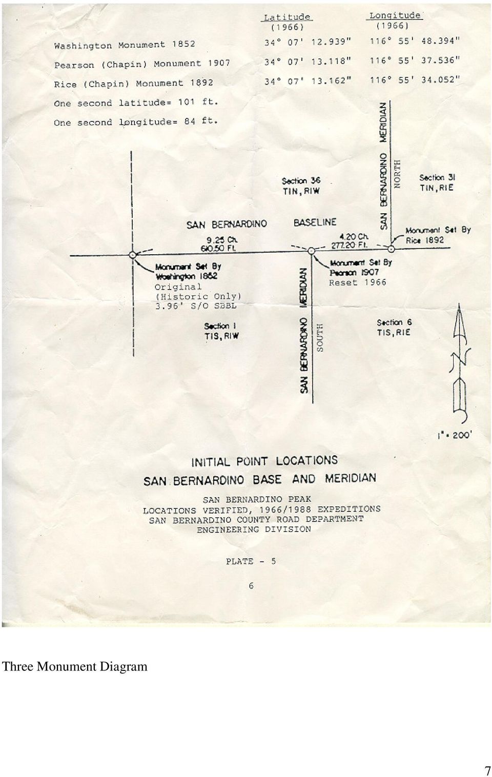
3 The San Bernardino Mountain about the monument was considered too rugged to attempt the survey of the Base and Meridian Lines from that point. Satisfied that the line could not have been measured with the requisite degree of accuracy. The saga picks up again eight days later in Washington s government notes dated November 17 th, 1852 with Washington beginning a traverse from his Point of Beginning, in what is now the City of Yucaipa. He records in his notes a bearing of South 45 West for his Point of Beginning from the Initial Point but gives no distance call (see the George Johnson Plat). He goes on to state that the Initial Point is plainly visible from the valley on that day. His random traverse then proceeds on courses called out as due North, South, East and West bearings for a distance of over 12 linear miles until he makes the statement, set a stake from which the monument on the top of San Bernardino Mountain established on the 8 th of November, 1852 bears due East, and the true distance, as ascertained by the foregoing lines shows it to be 13 miles, 9 chains, 80 links. Washington then goes on to traverse due East along the San Bernardino Baseline 1 mile, 9 chains, 80 links to the Township corner for Ranges 2 and 3 West. From this point Washington begins his township surveys of that area that evidentially returns him to the yet to be established Meridian Line 12 miles south of his Initial Point. In a report dated 1967 entitled Washington Monument Resurvey Expedition written by Mr. Bill D. Laurie for the San Bernardino County Museum, Mr. Laurie concludes that, To date, no record has been found which would indicate Washington s methods or procedures for surveying away from his initial point. This missing piece of the puzzle or, as the radio announcer Paul Harvey might say, the rest of the story regarding Washington s establishment of the San Bernardino Base and Meridian has still never been completely solved, though Mr. White has the most developed explanation in print. So I am challenged in this brief article to propose what I believe to be Colonel Washington s methodology for establishing the San Bernardino Base and Meridian without ever measuring from the Initial Point itself. I will also pose a challenge to the reasoning (as does Mr. White) behind the United States Government Land Office in accepting the rejection of Washington s corner twice, in the span of 55 years, after it was established. This despite the fact that the Washington Monument was never reported destroyed and was found by all subsequent surveyors in the area. George Johnson, a Cadastral Engineer for the Bureau of Land Management (BLM) produced a map in 1969 that summarizes the remaining government surveys necessary to complete the townships in the vicinity of Washington s Initial Point. The BLM can find no text to accompany this diagram to date, but it is very similar to Mr. White s summary in his chapter on the San Bernardino Initial Point. Johnson s map shows Henry Hancock, Deputy Surveyor running a series of township boundaries and traverses between the years of 1853 to 1857 that would return him to the 3
.")
4 Meridian Line 10 miles north of the Initial Point. Hancock s surveys covered over 34 linear miles. However, it would not be until 1894 that John C. Rice would finally complete the Meridian Line to the Initial Point from the north. And this is when the fun truly begins. Rice s notes describe him meeting the Baseline and finding Washington s monument chains (887 feet) to the West. It is then that Rice decides to set a new Initial Point, which he does, in much the same fashion as Washington did 42 years before him using a huge mound of stones and a large hewed post with scribing. He then runs the Baseline the final six miles to the West calling Washington s monument off line southerly by 4 feet as he goes by it. In similar fashion, George W. Pearson completes the Meridian Line from the south in 1907 and again finds both Washington and Rice s monuments intact. He decides to set a third point as a closing corner from the south, the monument being a large stone with chiseled markings, to Rice s Baseline and the last of the three Initial Points is born. Pearson s monument falls 610 feet east of Washington s monument and 277 feet west of Rice s monument (see Initial Point Diagram). The combined distances of the surveys needed to bring the north and south Meridian lines back to the Initial Point area is over 94 miles including Washington s initial traverse out of Yucaipa to his new Baseline. Questions abound as to where the errors were made to have the misclosures of nearly 900 feet in the northern townships and over 600 feet in the southern townships. Also critical to the analysis is discovering how Washington got down off the mountain which is what I hope to describe first. Washington knew all along that he would never be able to traverse his way off San Bernardino Mountain in time to produce Base and Meridian Lines needed to begin township surveys of the southern part of this promising new state, now only two years old. The idea for a tall post with reflectors had already been conceived in the Surveyor General s Office in San Francisco where the tin reflectors were manufactured. Washington s plan, that obviously included Ransom and King, was to set a tall enough post in an area that could be seen from at least two places from the valley below, one of which would be on the Baseline. We know from his notes he changed his plans to set the Initial Point on the very top of San Bernardino Mountain because he writes to the Surveyor General of the numerous trees on that peak. So he moves the point to a bald ridge area about ½ mile west of the top for better visibility. Washington randomly placed himself on a 45 angle from the Initial Point by use a solar compass to establish astronomic north and then wiggling in on this line. He then traversed in one mile intervals, avoiding any physical obstacles such as the Crafton Hills, until he got close to the Baseline. He would then need to again wiggle along a true north line until he could site the Initial Point again and find it to be due East of his position. Washington would then only have to add up the latitudes and departures of his traverse to establish two sides of the rectangle he constructed. With the two angles he had measured to the Initial Point, Washington would have created a simple trapezoid figure made up of rectangle and right triangle. Knowing the relationship of the sides of a right isosceles 4

5 triangle (1,1, 2) he could have obtained his distance west of the Initial Point by adding the sum of one long side of a rectangle and one side of his right triangle (see Mr. White's diagram). No higher mathematics were necessary. Washington hints at a simple mathematical solution when he states in his notes, the monument on the top of San Bernardino Mountain established on the 8 th of November, 1852 bears due East, and the true distance, as ascertained by the foregoing lines shows it to be 13 miles, 9 chains, 80 links. How accurate could Washington positioned his Initial Point with this methodology? Quite accurate if he could see the monument clearly and he had no major errors in his 12 mile traverse. A two minute error in either angle he turned to his Initial Point would have resulted in only a 40 foot error at most. A good sign that Washington did not make an error greater than this comes from his own notes of his establishment of the south line of Township 2 South, Range 1 West in late November, When he measured to what should have been the meridian line he states, Set temporary post - unable to see San Bernardino mountain there being a very high range of mountains about 5 miles to the North. Went southward to a high hill and then found the meridian from the monument to run 60 links (40 feet) East of the temporary post. It is more likely that one could find an error in Hancock s open-ended traverse that covered 34 miles, including an elevation change of nearly 3000 feet through Waterman Canyon. This appears to be the case when one studies his notes of 1857 carefully. As Hancock approaches the meridian line ten miles north of the Initial Point his last section is 90 chains long. But how did he "ascertain" this? Could he see the Initial Point five years after it was constructed? His notes do not say. Upon further research and profile analysis of the ground between Fawnskin, where Hancock established the meridian to the north, and the Initial Point it does appear that Hancock did sight Washington's monument to position himself longitudinally. My final questions concern John C. Rice. Why did Rice establish his own point in 1892? Why did he call Washington s monument an old temporary monument established by Deputy Washington in 1852? Why is Rice s last half mile chains if he planned to establish his own local Initial Point and Baseline? White s conclusion that Rice s monument should be treated as a closing corner seems difficult to accept because Rice had no line to close against, being nearly 900 feet east of Washington s Initial Point. I agree with Mr. White s conclusion that there is only ONE Initial Point and that is the monument constructed by Henry Washington in But I believe this should be officially documented by the BLM. I also believe the BLM should produce a new plat and notes showing some resolution of this interesting survey problem to re-establish the Washington s Monument as the true Initial Point. GPS measurements are planned to be taken by the author of the monuments established by Washington and Hancock in the 1850's. These measurements will be taken on the Baseline east and west of his Initial 5

6 Point, and north and south on the Meridians this summer to help complete a more thorough investigation of their relationship to Washington's Monument. With the 150 th anniversary fast approaching, the San Bernardino Mountain Sesquicentennial Anniversary Committee is sponsoring an anniversary hike on October 12 th, 2002 with the BLM, which will be filmed and documented, to commemorate Washington s important historical achievement. On November 9 th, 2002 the day Washington came down off the mountain, there will be a picnic at the Yucaipa Regional Park from 10:00 am to 4:00 pm. The celebration will include speakers, historical presentations, survey contests, games, a fishing tournament, exhibitions and lunch to celebrate the event with a larger, more diverse audience. For more information you can Michael Duffy at mduffy@mwdh2o.com or see the flyer in this issue of the California Surveyor. 6

7 Three Monument Diagram 7
8 C. Albert White Diagram 8

9 George Johnson Plat 9

10 Washington's Diagram of his Initial Point 10

Weekend Cabin Retreat Project Site Plans
 Weekend Cabin Retreat Project Site Plans Sacramento City College EDT 300/ENGR 306 EDT 300/ENGR 306 - Site Plans 1 Cabin Project Site Plan/Bubble Diagram - Assignment 1 =10-0 Floor Plan - Assignment 1/4
CHAPTER 8 - LAND DESCRIPTIONS
 CHAPTER 8 - LAND DESCRIPTIONS Notes: While the location of land is commonly referred to by street number and city, it is necessary to use the legal description in the preparation of those instruments relating
FORMULA FOR FINDING THE SQUARE FEET OF A RECTANGLE L x W = A
 UNIT I REAL ESTATE MATH AREA MEASUREMENTS FORMULA FOR FINDING THE SQUARE FEET OF A RECTANGLE L x W = A Where: A = Area L = Length W = Width If the length = 30 and the width = 20 20 x 30 = 600 Sq. Feet
U.S. PUBLIC LAND SURVEY SYSTEM
 UNIT 12 U.S. PUBLIC LAND SURVEY SYSTEM Jim McCavitt, PLS Bureau of Land Management Introduction The United States Public Land Survey System (PLSS) began with the Land Ordinance of 1785. The ordinance provided
Legal Descriptions. Chapter 9
 Legal Descriptions Chapter 9 Legal Description Defined A description of land is legally sufficient if it allows a competent surveyor to locate the parcel. This means locate and define boundaries 2 When
Basic Rectangular Surveys
 Basic Rectangular Surveys The Public Land Survey System What Are We Going To Talk About? The rectangular survey system How it is designed How the surveys were supposed to be performed Some unique aspects
There is no "standard' per se for the survey and control data. Simply put, we will use whatever works best.
 INTRODUCTION The geographic coordinate data base (GCDB) is a data base containing geographic coordinates, and their associated attributes, for all corners of the Public Land Survey System (PLSS). It is
Understanding Land Measurement and Legal Descriptions
 Lesson A2 1 Understanding Land Measurement and Legal Descriptions Unit A. Mechanical Systems and Technology Problem Area 2. Soil and Environmental Technology Systems Lesson 1. Understanding Land Measurement
PART VI: BOUNDARY SURVEYING
 PART VI: BOUNDARY SURVEYING 6.1 The U.S. Rectangular Survey System (Overview) The Public Land Survey System in Michigan is referenced to two axes. The North and South axis is the Michigan Principal Meridian
ELEMENTS OF SURVEYING FOR CADASTRAL MAPPING
 ELEMENTS OF SURVEYING FOR CADASTRAL MAPPING Chapter 4 2015 Cadastral Mapping Manual 4-0 Elements of Surveying and Mapping Utah's system of land surveying is the rectangular survey system as set forth on
About Fact Sheets Contact Us Partners Products Site Map FAQ Help
 About Fact Sheets Contact Us Partners Products Site Map FAQ Help Home Articles PLSS Article The Public Land Survey System (PLSS) What is the PLSS? History Commonly Used Terms Related Links What is the
Public Land Survey System - Definition
 Public Land Survey System - Definition The Public Land Survey System (PLSS) is a method used in the United States to locate and identify land, particularly for titles and deeds of farm or rural land. The
CHAPTER 4 LEGAL DESCRIPTION OF LAND DESCRIBING LAND METHODS OF DESCRIBING REAL ESTATE
 r CHAPTER 4 LEGAL DESCRIPTION OF LAND DESCRIBING LAND A legal description is a detailed way of describing a parcel of land for documents such as deeds and mortgages that will be accepted in a court of
STATE OF ALASKA DEPARTMENT OF NATURAL RESOURCES DIVISION OF MINING, LAND AND WATER. GENERAL SURVEY INSTRUCTIONS EASEMENTS Authority 11 AAC 53
 STATE OF ALASKA DEPARTMENT OF NATURAL RESOURCES DIVISION OF MINING, LAND AND WATER GENERAL SURVEY INSTRUCTIONS EASEMENTS Authority 11 AAC 53 These instructions define the survey and platting criteria unique
GEOGRAPHIC INFORMATION SYSTEMS Lecture 11: Land Division Systems
 GEOGRAPHIC INFORMATION SYSTEMS Lecture 11: Land Division Systems Land Division Systems - in many applications of GIS, land ownership is an important data layer and it is important for GIS users to be familiar
PUSD High Frequency Word List
 PUSD High Frequency Word List For Reading and Spelling Grades K-5 High Frequency or instant words are important because: 1. You can t read a sentence or a paragraph without knowing at least the most common.
Mastering U.S. LEGAL DESCRIPTIONS
 www.landtraining.net Mastering U.S. LEGAL DESCRIPTIONS This FREE Webinar is offered by Midland College in collaboration with Alyce Hoge of Land Training. Alyce Hoge is the instructor for the Midland College
Indiana Survey Townships
 Page 46 IN-GENious! The Rectangular Survey System in Indiana and Using the GIS Atlas by Annette Harper You ve found a wonderful deed or land patent and now you d like to pinpoint exactly where your ancestor
CHAPTER 7 TRAVERSE Section I. SELECTION OF TRAVERSE DEFINITION
 CHAPTER 7 TRAVERSE Section I. SELECTION OF TRAVERSE DEFINITION A traverse is a series of straight lines called traverse legs. The surveyor uses them to connect a series of selected points called traverse
Finding Real Property: Legal Descriptions
 Finding Real Property: Legal Descriptions LEARNING OBJECTIVES Upon completion of this chapter, the student should be able to: Explain the importance of an accurate legal description. Relate the three methods
NC General Statutes - Chapter 102 1
 Chapter 102. Official Survey Base. 102-1. Name and description. The official survey base for the State of North Carolina shall be a system of plane coordinates to be known as the "North Carolina Coordinate
Title 10 DEPARTMENT OF NATURAL RESOURCES Division 35 Land Survey Chapter 1 Cadastral Mapping Standards
 Title 10 DEPARTMENT OF NATURAL RESOURCES Division 35 Land Survey Chapter 1 Cadastral Mapping Standards 10 CSR 35-1.010 Application of Standards PURPOSE: These minimum standards provide the digital mapper
Legal Description Conundrums
 Legal Description Conundrums Robert L. Russell, Russell Law Office Fergus Falls, MN rrussell@prtel.com 218-998-6400 Dennis Pederson, L.S., Bogart Pederson & Assoc., Inc. Becker, MN dpederson@bogart-pederson.com
Survey Ties Guidelines
 North Carolina Board of Examiners for Engineers and Surveyors Survey Ties Guidelines The North Carolina Board of Examiners for Engineers and Surveyors is providing this document to serve as an interpretative
Title 10 DEPARTMENT OF NATURAL RESOURCES Division 35 Land Survey Chapter 1 Cadastral Mapping Standards
 Title 10 DEPARTMENT OF NATURAL RESOURCES Division 35 Land Survey Chapter 1 Cadastral Mapping Standards 10 CSR 35-1.010 Application of Standards PURPOSE: These minimum standards provide the digital mapper
CHAPTER 4 EARTHWORK. Section I. PLANNING OF EARTHWORK OPERATIONS
 CHAPTER 4 EARTHWORK Section I. PLANNING OF EARTHWORK OPERATIONS IMPORTANCE In road, railroad, and airfield construction, the movement of large volumes of earth (earthwork) is one of the most important
G.S. 47-30 Mapping Requirements for Recordable Maps
 G.S. 47-30 Mapping Requirements for Recordable Maps 47-30. Plats and subdivisions; mapping requirements. (a) Size Requirements. All land plats presented to the register of deeds for recording in the registry
MINIMUM STANDARDS OF ACCURACY, CONTENT AND CERTIFICATION FOR SURVEYS AND MAPS ARTICLE I. TYPES OF SURVEYS
 MINIMUM STANDARDS OF ACCURACY, CONTENT AND CERTIFICATION FOR SURVEYS AND MAPS ARTICLE I. TYPES OF SURVEYS Current with material published in Conn.L.J. through 5/13/08 Sec. 20-300b-1. General There are
Visualizing Metes and Bounds Property Descriptions on Google Maps and Google Earth
 Visualizing Metes and Bounds Property Descriptions on Google Maps and Google Earth Presented by James L. Tanner Genealogy's Star http://genealogysstar.blogspot.com New online tools allow you to identify
Chapter 7: Land Descriptions
 Chapter 7: Land Descriptions 7. Land Descriptions An * in the left margin indicates a change in the statute, rule or text since the last publication of the manual. I. Introduction While the location of
Maps A Primer for Content & Production of Topographic Base Maps For Design Presented by SurvBase, LLC
 Maps A Primer for Content & Production of Topographic Base Maps For Design Presented by Definition and Purpose of, Map: a representation of the whole or a part of an area. Maps serve a wide range of purposes.
Standard Surveying Terms
 Standard Surveying Terms Aliquot - The description of fractional section ownership used in the U.S. public land states. A parcel is generally identified by its section, township, and range. The aliquot
Brevard County Public Works Finance and Contracts Administration
 Brevard County Public Works Finance and Contracts Administration Public Works Survey & Mapping Division Review Check Sheet for Land Acquisition, Drainage, Roadway and Pedway Expansion, Asbuilts, Maintenance
LAND SURVEYING PROGRAM QUESTIONS AND ANSWERS
 LAND SURVEYING PROGRAM QUESTIONS AND ANSWERS Written by Dennis J. Mouland, P.L.S., Regional Surveyor Southwest Region Originally compiled by Joan L. Fritz, Land Surveys, Idaho Panhandle National Forest
SEE THE USA FOR $50 A DAY
 Travel Cheap (Rev 3) Karl Belser 17 October 2002 5544 Drysdale Drive (1415 words) San Jose, CA 95124 408-723-0315 SEE THE USA FOR $50 A DAY By Karl Arnold Belser Do you like to travel, have limited money,
Topographic Maps Practice Questions and Answers Revised October 2007
 Topographic Maps Practice Questions and Answers Revised October 2007 1. In the illustration shown below what navigational features are represented by A, B, and C? Note that A is a critical city in defining
Fry Phrases Set 1. TeacherHelpForParents.com help for all areas of your child s education
 Set 1 The people Write it down By the water Who will make it? You and I What will they do? He called me. We had their dog. What did they say? When would you go? No way A number of people One or two How
The Secret of Cell Phones By R. Howard
 The Secret of Cell Phones The Secret of Cell Phones By R. Howard Maria was very excited: her parents were finally going to buy her a cell phone. Most of her friends had already been given a cell phone
Tax Parcel Mapping. Visual Representations of Legal Descriptions and So Much More
 Tax Parcel Mapping Visual Representations of Legal Descriptions and So Much More Topics I. E-Distribution II. GIS & Tax Mapping III. Tax Mapping Procedures IV. Deeds, Property Descriptions, & You! I. E-Distribution
Survey of the Louisiana Purchase in 1815
 Lesson Strategy for the Louisiana Purchase Bicentennial Instructor Copy Survey of the Louisiana Purchase in 1815 Grades: 4-12 Suggested Time Frame: Two, 50-minute class periods Objectives: To understand
Earth In Space Chapter 3
 Earth In Space Chapter 3 Shape of the Earth Ancient Greeks Earth casts a circular shadow on the moon during a lunar eclipse Shape of the Earth Ancient Greeks Ships were observed to disappear below the
Mathematics as Reasoning Students will use reasoning skills to determine the best method for maximizing area.
 Title: A Pen for Penny Brief Overview: This unit is a reinforcement of the concepts of area and perimeter of rectangles. Methods for maximizing area while perimeter remains the same are also included.
SUPERIOR COURT OF CALIFORNIA, COUNTY OF LOS ANGELES STANLEY MOSK COURTHOUSE
 Stephen R. Cornwell, CA Bar #0 CORNWELL & SAMPLE, LLP Attorneys at Law 0 N. Fruit Avenue Fresno, CA -01 Telephone: () 1- Facsimile: () -1 Attorneys for Plaintiffs MARNI ILENE KATZ COTTER; REN VINCENT COTTER
2005 MINIMUM STANDARD DETAIL REQUIREMENTS FOR ALTA/ACSM LAND TITLE SURVEYS
 2005 MINIMUM STANDARD DETAIL REQUIREMENTS FOR ALTA/ACSM LAND TITLE SURVEYS as adopted by American Land Title Association and National Society of Professional Surveyors (a member organization of the American
FPO SURVEYORS. www.calmis.ca.gov WHAT DOES A SURVEYOR DO?
 SURVEYORS CALIFORNIA OCCUPATIONAL GUIDE - NUMBER 106 2003 INTEREST AREA INVESTIGATIVE FPO used landmarks such as specific tree groves, rocks (even rock shapes-such as ship rock ) and riverbanks to record
Oregon Cadastral Map System
 Chapter 4 Oregon Cadastral Map System Purpose The primary purpose of the Oregon Cadastral Map System is to discover, identify, and inventory all real property within the state of Oregon. A joint effort
Quartz Mining Act Guidelines for Claim Staking. Please use the following document as a guide when staking and recording claims in Yukon.
 Quartz Mining Act Guidelines for Claim Staking Please use the following document as a guide when staking and recording claims in Yukon. Before you set out to stake your own Yukon mineral claim, read these
Re: Preliminary Permit Application for the Rose Creek Pumped Storage Project
 September 12, 2013 Kimberly D. Bose, Secretary Federal Energy Regulatory Commission 888 First Street, N.E. Washington, D.C. 20426 Re: Preliminary Permit Application for the Dear Ms. Bose, Please find attached
Benton MacKaye Trail - Section 2. Three Forks (FS 58) to GA. Highway 60. 11.4 miles
 to GA. Highway 60. 11.4 miles") General Benton MacKaye Trail - Section 2 Three Forks (FS 58) to GA. Highway 60 11.4 miles This is the longest and most remote section of the Benton MacKaye Trail (BMT) east of GA 5. It follows the Appalachian
General Benton MacKaye Trail - Section 2 Three Forks (FS 58) to GA. Highway 60 11.4 miles This is the longest and most remote section of the Benton MacKaye Trail (BMT) east of GA 5. It follows the Appalachian
Trail Tree Newsletter October 2014
 Trail Tree Newsletter October 2014 This is the Volume 26 of the Quarterly Trail Tree Project Newsletter. We hope the number of topics in this newsletter will be of interest to you. If you want us to report
RADIO TALKS ON SCIENCE 1 TREE RINGS AND CLIMATE UNIVERSITY OF ARIZONA
 Reprinted from THE SCIENTIFIC MONTHLY, July, 1925, Vol. XXI, pages 95-99 RADIO TALKS ON SCIENCE 1 TREE RINGS AND CLIMATE By Professor A. E. DOUGLASS UNIVERSITY OF ARIZONA IF trees could talk, they would
www.pdhcenter.com PDH Course L118 www.pdhonline.org Basic Public Lands Jan Van Sickle, PLS
 Basic Public Lands Jan Van Sickle, PLS From the very beginning of the Public Land Surveying System it has always been the policy of the Federal Government that land in the public domain must be surveyed
Chapter 9 Questions Legal Descriptions
 Chapter 9 Questions Legal Descriptions 1. How many acres are in a lot that is 1/4 of a mile wide by 1/4 of a mile long? a. 10 b. 120 c. 40 d. 80 2. The numbering of sections in a township begins in the
Phonics. High Frequency Words P.008. Objective The student will read high frequency words.
 P.008 Jumping Words Objective The student will read high frequency words. Materials High frequency words (P.HFW.005 - P.HFW.064) Choose target words. Checkerboard and checkers (Activity Master P.008.AM1a
It is 1969 and three Apollo 11
 The Man Who Went to the Far Side of the Moon by Bea Uusma Schyffert Reading Level (Lexile) 850L Format/Length Biography, 80 pages Picture Support Photos, diagrams, and illustrations Language Register Middle
Legal Description of Unit A
 Legal Description of Unit A All bearings are true mean bearings, as orientated to North American 1927 Datum (NAD 27), as determined from the National Geodetic Reference System, unless otherwise noted.
The Basics of Navigation
 The Basics of Navigation Knowledge of map reading and the use of the compass is an indispensable skill of bushcraft. Without this skill, a walker is a passenger and mere follower on a trip. To become a
Basics of rectangular survey platting Platting one owner s land (fictional)
") Understanding Land Records: Introduction to Land Platting Agenda: 8:30am 9:45am 10:15am 11:30am 1:00pm 2:15pm Introduction Basics of rectangular survey platting Platting one owner s land (fictional) Platting
Understanding Land Records: Introduction to Land Platting Agenda: 8:30am 9:45am 10:15am 11:30am 1:00pm 2:15pm Introduction Basics of rectangular survey platting Platting one owner s land (fictional) Platting
Part 5 U.S. Public Land Survey System
 National Mapping Program Technical Instructions Part 5 U.S. Public Land Survey System Standards for 1:24,000-Scale Digital Line Graphs-3 Core U.S. Department of the Interior U.S. Geological Survey National
Focus On You Photography TRT from Brockway Summit to Watson Lake
 Tahoe Rim Trail (TRT) From Hwy 267 (Brockway Summit) west to Watson Lake (Strong Intermediate Advanced) This trail is very demanding. It is almost 2100 ft. of climbing. The trail is up and down, up and
Eagle Mountain Pumped Storage Project No. 13123 Final License Application Volume 6 of 6. Exhibit G Project Boundary PUBLIC. Palm Desert, California
 PUBLIC Eagle Mountain Pumped Storage Project No. 13123 Final License Application Volume 6 of 6 Exhibit G Project Boundary Palm Desert, California Submitted to: Federal Energy Regulatory Commission Submitted
Geometry 1. Unit 3: Perpendicular and Parallel Lines
 Geometry 1 Unit 3: Perpendicular and Parallel Lines Geometry 1 Unit 3 3.1 Lines and Angles Lines and Angles Parallel Lines Parallel lines are lines that are coplanar and do not intersect. Some examples
STONEHENGE AS A SOLSTICE INDICATOR
 STONEHENGE AS A SOLSTICE INDICATOR One of the most impressive megalithic structures in the world is Stonehenge just north of Salisbury, England. I first visited the monument during my post-doctorate year
PETRIFIED LIGHTNING. by PETER E. VIEMEISTER ORIGINALLY PUBLISHED IN
 PETRIFIED LIGHTNING by PETER E. VIEMEISTER ORIGINALLY PUBLISHED IN THE LIGHTNING BOOK THE MIT PRESS, 1983 ORIGINALLY PUBLISHED IN THE LIGHTNING BOOK THE MIT PRESS, 1983 PETRIFIED LIGHTNING by PETER E.
The Accuracy of the Original. GLO Surveys. And Their Relationship to Modern Surveying Technology. Milton Denny, PLS
 The Accuracy of the Original GLO Surveys And Their Relationship to Modern Surveying Technology Milton Denny, PLS 66 foot Survey Chain A. Contract Surveyor Given Instructions for their Area of Work B. C.
BLOCK 400 PLANNED COMMUNITY DISTRICT
 BLOCK 400 PLANNED COMMUNITY DISTRICT Newport Center December 1983 Newport Beach, California Ordinance 88-119 Adopted December 12, 1988 Amendment No. 672 Resolution No. 95-115 Adopted October 9, 1995 Amendment
PRACTICAL BLOCK COMPASS BASICS. Compass Basics. Introduction. The Silva Compass
 Compass Basics Introduction The first compass was, no doubt, a magnetised ore-bearing rock or stone, that when suspended, would always point the same way. No one knows who first discovered the compass;
CRANBERRY ISLES REALTY TRUST 2009 MORTGAGE DEED. ( Mortgagors ), for consideration paid, does hereby GIVE, GRANT,
, for consideration paid, does hereby GIVE, GRANT,") MORTGAGE DEED KNOW ALL MEN BY THESE PRESENTS, That ( Mortgagors ), for consideration paid, does hereby GIVE, GRANT, BARGAIN, SELL AND CONVEY unto CRANBERRY ISLES REALTY TRUST ( Mortgagee ), its successors
MORTGAGE DEED KNOW ALL MEN BY THESE PRESENTS, That ( Mortgagors ), for consideration paid, does hereby GIVE, GRANT, BARGAIN, SELL AND CONVEY unto CRANBERRY ISLES REALTY TRUST ( Mortgagee ), its successors
ERIC C. CAMP WHITAKER, CHALK, SWINDLE & SAWYER, LLP 301 COMMERCE STREET, SUITE 3500 FORT WORTH, TEXAS 76102 (817) 878-0500 ECAMP@WHITAKERCHALK.
 878-0500 ECAMP@WHITAKERCHALK.") NATURAL GAS PIPELINE EASEMENT AND RIGHT-OF-WAY AGREEMENTS: ERIC C. CAMP WHITAKER, CHALK, SWINDLE & SAWYER, LLP 301 COMMERCE STREET, SUITE 3500 FORT WORTH, TEXAS 76102 (817) 878-0500 ECAMP@WHITAKERCHALK.COM
NATURAL GAS PIPELINE EASEMENT AND RIGHT-OF-WAY AGREEMENTS: ERIC C. CAMP WHITAKER, CHALK, SWINDLE & SAWYER, LLP 301 COMMERCE STREET, SUITE 3500 FORT WORTH, TEXAS 76102 (817) 878-0500 ECAMP@WHITAKERCHALK.COM
Plotting and Adjusting Your Course: Using Vectors and Trigonometry in Navigation
 Plotting and Adjusting Your Course: Using Vectors and Trigonometry in Navigation ED 5661 Mathematics & Navigation Teacher Institute August 2011 By Serena Gay Target: Precalculus (grades 11 or 12) Lesson
#1258. WHEREAS, the Board of Commissioners of the Township of Haddon has determined the following:
 #1258 ORDINANCE OF THE TOWNSHIP OF HADDON, COUNTY OF CAMDEN AND STATE OF NEW JERSEY SUPPLEMENTING, AMENDING AND REVISING CHAPTER 142-38 OF THE TOWNSHIP OF HADDON ENTITLED, CONDITIONAL USES WHEREAS, The
SURVEY DIRECTIONS Tasmania. Pursuant to the Surveyors Act 2002
 SURVEY DIRECTIONS Tasmania Pursuant to the Surveyors Act 2002 Revision Status Revision Date: 101214 Part / Schedule Division Heading Last Revision Date Table of Contents 101214 Part 1 Preliminary 101214
World Map Lesson 4 - The Global Grid System - Grade 6+
 World Map Lesson 4 - The Global Grid System - Grade 6+ Activity Goal To use the global grid system of latitude and longitude to find specific locations on a world map. Materials Needed: A pencil, a ruler,
1. We assume the mentioned inaccuracies refer to the at least one foot in ten thousand standard described in point three.
 RFQ GIS Parcel Boundary Correction Services BD 2015-035 Questions and Answers December 31st December 10 th 1. We assume the mentioned inaccuracies refer to the at least one foot in ten thousand standard
So how much does it cost?
 17 Math Challenge # PERPLEXING PERCENTAGES So how much does it cost Figure This! Is a discount of 30% off the original price, followed by a discount of 50% off the sale price, the same as a discount of
SQUARE-SQUARE ROOT AND CUBE-CUBE ROOT
 UNIT 3 SQUAREQUARE AND CUBEUBE (A) Main Concepts and Results A natural number is called a perfect square if it is the square of some natural number. i.e., if m = n 2, then m is a perfect square where m
SUR 360, PUBLIC LAND SURVEY SYSTEM Great Basin College, Fall 2012 Course Syllabus August 15, 2012
 SUR 360, PUBLIC LAND SURVEY SYSTEM Great Basin College, Fall 2012 Course Syllabus August 15, 2012 Instructor: Steve Parrish, PLS Reno, NV Office hours: Email to set appointment Home: 775-852-9331 (eve)
Lesson 2: The Nature of Real Property. Real Property. Real Property. Real Estate Principles of Georgia. vs. Personal Property.
 Real Estate Principles of Georgia Lesson 2: The Nature of Real Property 1 of 53 23 Real Property vs. Personal Property Two types of property: Real property, ( realty ), real estate Personal property (
SOUTH AMERICA CONTENTS. What s in This Book... 2. Section 1: South America in the World... 3. Section 2: Political Divisions of South America...
 SOUTH CONTENTS What s in This Book 2 Section 1: 3 Section 2: Political Divisions of 1 Section 3: Physical Features of 41 Section 4: Valuable Resources of 67 Section : n Culture 89 Section 6: Assessment
Il.oma. s lv,lfo... csl P«.pid B... t..f. Gco. s".,!it. 2 t-+----rt .141, ..:Ioia"~n '60. f7hil,~~ fc'lhe.r; {r; ZIIO
 Il.oma. s lv,lfo... csl P«.pid B... t..f Gco. s".,!it 2 t-+----rt go.141,..:ioia"~n '60 f7hil,~~ fc'lhe.r; {r; ZIIO A DEQUATE legal descriptions are essential in many types of legal J-\... instruments
PROCEDURAL AND TECHNICAL STANDARDS For The Practice of Land Surveying In The State of Rhode Island And Providence Plantations
 PROCEDURAL AND TECHNICAL STANDARDS For The Practice of Land Surveying In The State of Rhode Island And Providence Plantations Prepared By The Rhode Island Society of Professional Land Surveyors Inc. and
Mathematics (Project Maths Phase 1)
") 2012. M128 S Coimisiún na Scrúduithe Stáit State Examinations Commission Leaving Certificate Examination, 2012 Sample Paper Mathematics (Project Maths Phase 1) Paper 2 Ordinary Level Time: 2 hours, 30
2012. M128 S Coimisiún na Scrúduithe Stáit State Examinations Commission Leaving Certificate Examination, 2012 Sample Paper Mathematics (Project Maths Phase 1) Paper 2 Ordinary Level Time: 2 hours, 30
CULTURAL HISTORY The United States Public Land Survey System The Rectangular Grid By Neal McLain
 CULTURAL HISTORY The United States Public Land Survey System The Rectangular Grid By Neal McLain In last month's column, I discussed the origin of the United States Public Land Survey System (USPLSS, or
Model Virginia Map Accuracy Standards Guideline
 Commonwealth of Virginia Model Virginia Map Accuracy Standards Guideline Virginia Information Technologies Agency (VITA) Publication Version Control Publication Version Control: It is the user's responsibility
FORESIGHT LAND SURVEYING, INC. 410 N. Sugar Street Brownstown, IN 47220 Phone: 812-358-4170 Fax: 812-358-4192
 FORESIGHT LAND SURVEYING, INC. 410 N. Sugar Street Brownstown, IN 47220 Phone: 812-358-4170 Fax: 812-358-4192 Mining Services: Boundary Surveys Topographic Surveys Volume Surveys Mine Mapping Surface &
State Land States vs. Public Land States
 Public Lands Survey System Rectangular Survey System Sections, Ranges, Townships Roberta Bobbi King Lakewood, Colorado State Land States vs. Public Land States State Land States: Metes and bounds twenty
Earth Coordinates & Grid Coordinate Systems
 Earth Coordinates & Grid Coordinate Systems How do we model the earth? Datums Datums mathematically describe the surface of the Earth. Accounts for mean sea level, topography, and gravity models. Projections
Searching Land Records thru the BLM General Land Office Records.
 Searching Land Records thru the BLM General Land Office Records. Land Records can be an exciting addition to your family history search. The United States Government transferred ownership of land to millions
Ohio Surveys Some References and History Nancy von Meyer April 2012. http://www.roxalumni.com/member_dosurvey.cfm?surveyid=12579
 Ohio Surveys Some References and History Nancy von Meyer April 2012 This document is a summary of the information provided by Charlie Hicks in an email and has been combined with other references for a
Phonics. P.041 High Frequency Words. Objective The student will read high frequency words.
 2005 The Florida Center for Reading Research (Revised, 2008) Objective The student will read high frequency words. Phonics P.041 High Frequency Words Sandpaper Words Materials Tactile word patterns (Activity
Mapping & Agricultural Manual
 State of Wyoming Department of Revenue 122 West 25th Street Cheyenne, Wyoming 82002-0110 Foreword The increasing need for land information, at all levels of government and in the private sector, has resulted
CELESTIAL MOTIONS. In Charlottesville we see Polaris 38 0 above the Northern horizon. Earth. Starry Vault
 CELESTIAL MOTIONS Stars appear to move counterclockwise on the surface of a huge sphere the Starry Vault, in their daily motions about Earth Polaris remains stationary. In Charlottesville we see Polaris
Lesson 26: Reflection & Mirror Diagrams
 Lesson 26: Reflection & Mirror Diagrams The Law of Reflection There is nothing really mysterious about reflection, but some people try to make it more difficult than it really is. All EMR will reflect
The Three Little Pigs
 Setting (When, who, where) The Three Little Pigs Once upon a time, there were three little pigs who wanted to live in their own homes. Together they went looking at houses. Beginning Event (What starts
Laboratory 6: Topographic Maps
 Name: Laboratory 6: Topographic Maps Part 1: Construct a topographic map of the Egyptian Pyramid of Khafre A topographic map is a two-dimensional representation of a three-dimensional space. Topographic
Historical Marker No. 7 U.S. Mormon Battalion Trail Monument 1½ Miles East of Arizona-New Mexico Border, Hidalgo County, New Mexico
 Historical Marker No. 7 U.S. Mormon Battalion Trail Monument 1½ Miles East of Arizona-New Mexico Border, Hidalgo County, New Mexico TRAIL SEGMENT 2. Main Command TRAIL DATE 28 Nov 1846 DEDICATION DATE
Geography affects climate.
 KEY CONCEPT Climate is a long-term weather pattern. BEFORE, you learned The Sun s energy heats Earth s surface unevenly The atmosphere s temperature changes with altitude Oceans affect wind flow NOW, you
Article 2 Survey and Platting Standards
 Article 2: Survey and Platting Standards Article 5: Platting Authority in the Unorganized Borough Article 6: General Provisions Section 100. Applicability. 110. General survey standards. 120. Technical
WEIGHTS AND MEASURES. Linear Measure. 1 Foot12 inches. 1 Yard 3 feet - 36 inches. 1 Rod 5 1/2 yards - 16 1/2 feet
 WEIGHTS AND MEASURES Linear Measure 1 Foot12 inches 1 Yard 3 feet - 36 inches 1 Rod 5 1/2 yards - 16 1/2 feet 1 Furlong 40 rods - 220 yards - 660 feet 1 Mile 8 furlongs - 320 rods - 1,760 yards 5,280 feet
IN A SMALL PART OF THE CITY WEST OF
 p T h e L a s t L e a f IN A SMALL PART OF THE CITY WEST OF Washington Square, the streets have gone wild. They turn in different directions. They are broken into small pieces called places. One street