ORDINANCE NO. WHEREAS, the Planning and Zoning Board held a public hearing on January
|
|
|
- Pamela Fleming
- 8 years ago
- Views:
Transcription
1 VI-A-2 MAY 18, 2015 ORDINANCE NO. PROPOSED ORDINANCE NO AN ORDINANCE RELATING TO ZONING; AMENDING ORDINANCE 5239; PROVIDING FOR A MODIFICATION TO PUD ZONING TO ADD APPROXIMATELY 1.89 ACRES, TO INCREASE THE MAXIMUM RETAIL/SERVICE LIMIT FROM 360,000 TO 378,000 SQUARE FEET AND MODIFY THE MASTER SIGN PLAN ON PROPERTY LOCATED AT 919 LAKELAND PARK CENTER DRIVE; PROVIDING CONDITIONS; FINDING CONFORMITY WITH THE COMPREHENSIVE PLAN; PROVIDING AN EFFECTIVE DATE. WHEREAS, the Planning and Zoning Board held a public hearing on January 21, 2015, to consider the request of Jane L. Caldera, P.E. with Truckin Traffic, LLC, on behalf of Ramco Gateway, LLC, to modify the PUD zoning to add approximately 1.89 acres, to increase the maximum retail/service limit from 360,000 to 378,000 square feet and modify the master sign plan on property located at 919 Lakeland Park Center Drive, more particularly described in Attachment A and graphically depicted on Attachment B and C ; and WHEREAS, the Planning and Zoning Board approved the PUD zoning modifications on February 17, 2015, and recommended them to the City Commission; and WHEREAS, the City Commission of the City of Lakeland, Florida, after publication of a notice of its consideration of this ordinance, has determined that it is in the best interests of the City of Lakeland to modify PUD zoning for property located at 919 Lakeland Park Center Drive to add approximately 1.89 acres, to 1

2 increase the maximum retail/service limit from 360,000 to 378,000 square feet and modify the master sign plan; and WHEREAS, the City Commission, having held a public hearing pursuant to said notice, where interested parties were given opportunity to be heard, finds the property should be classified or zoned as recommended by the Planning and Zoning Board. NOW, THEREFORE, BE IT ORDAINED BY THE CITY COMMISSION OF THE CITY OF LAKELAND, FLORIDA: SECTION 1. The property legally described in Attachment A, owned by Ramco Gateway, LLC, LLC. and located within the City of Lakeland, is classified or zoned PUD (planned unit development) as set forth in Attachments B and C, subject to the following amended conditions: A. Permitted Uses: 1. A regional retail shopping center with outparcels, including those uses permitted in the C-5 (Regional Center Commercial) zoning district, except that the following principal uses shall be prohibited: Funeral homes and crematoriums Mobile home sales, rental and service agencies Motor vehicle and boat sales and rental Outdoor commercial recreation Regulated uses Retail marine sales and service (Marine accessory stores, which may include the incidental sales and service of watercraft, are permitted.) 2. Overnight boarding of animals and veterinary clinics are permitted as an accessory use provided that such uses are (a) located within a completely enclosed building and (b) incidental and accessory to a pet supply store as the principal use. 3. In order to regulate the amount of diverted trips that enter the project site from I-4 via US 98, no more than four of the outparcels shall include drive-through facilities, except, however, that banks and other 2
 as set forth in Attachments B and C, subject to the following amended conditions: A. Permitted Uses: 1.")
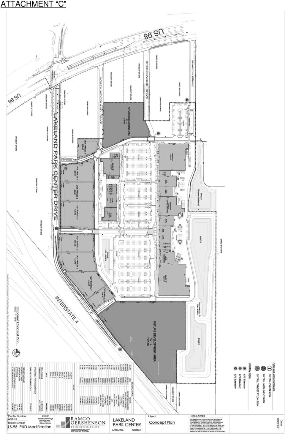
3 financial institutions may have drive-through facilities which shall not count toward the four-parcel limit. B. Development Limits: 1. Maximum Allowed Development by Type, subject to conversion in (2) below: Retail/Service: Office: Hotel/Motel: 360,000378,000 square feet 40,000 square feet 135 rooms 2. Conversion of Development Types: The amount of development may be converted from one type to another without requiring a change to this PUD in accordance with the following Vehicle Trip Equivalency Matrix, except that no more than 20,000 square feet of the allowed office uses may be converted. VEHICLE TRIP EQUIVALENCY MATRIX C H A N G E F R O M RETAIL/SERVICE (1,000 Sq.Ft.) OFFICE (1,000 Sq.Ft.) HOTEL/MOTEL (Rooms) CHANGE TO RETAIL/ SERVICE (1,000 Sq.Ft.) OFFICE (1,000 Sq.Ft.) HOTEL/ MOTEL (Rooms) EXAMPLE #1: To convert from retail to hotel, multiply the number of desired hotel rooms by the retail equivalency factor to get the number of equivalent reduction in retail square footage. 50 hotel rooms x (retail equiv. factor) = x 1,000 = 10,300 sq. ft. retail To add 50 hotel rooms, reduce retail by 10,300 sq. ft. EXAMPLE #2: To convert from hotel to office, multiply the desired office square footage by the hotel equivalency factor to get the number of equivalent hotel room reduction. 20,000 sq. ft. office x (hotel equiv. factor) = 46,600 / 1,000 = 46.6 hotel rooms To add 20,000 sq. ft. office, reduce hotel by 47 rooms C. Site Development Plan: The project shall be developed in substantial accordance with the site development plan included as Attachment "C. With the approval of the Director of Community Development, minor adjustments 3

4 can be made to lot configuration, structure configuration and parking configuration at the time of final site plan review without requiring a change to this PUD. In the event that a station site for the new Florida High-Speed Rail system is selected in the north central Lakeland area, the developer shall agree to cooperate with the City and other stakeholders regarding complementary uses or layout scenarios to support this new facility and transportation service to the maximum extent that is feasible. However, the obligation for the developer to cooperate shall not reduce any entitlements granted by this PUD. D. Development StandardsRegulations: In accordance with C-5/Suburban Center zoning sub-district standardsregulations, except as below or as otherwise provided herein. For purposes of this ordinance, unified development shall mean all buildings identified as Major, Retail and Anchor in Attachment C and the associated parking areas. Outparcel shall mean all parcels identified as Out Parcel or Future Development Area in Attachment C. 1. Minimum Unified Development Building Bulk StandardsRegulations: Minimum building setbacks: In accordance with Attachment C. 2. Minimum Outparcel Building Bulk StandardsRegulations: a. Minimum building setbacks: In accordance with C-2/Suburban Center (Highway Commercial) zoning sub-district standardsregulations except that there shall be no minimum setbacks from property lines which are not boundaries of the unified development. b. Maximum building height: Retail uses: 40 feet. E. Architectural Design Standards: Hotels/motels and office uses: 44 feet or 1 foot in height for each 1 foot in setback from boundaries of unified development, whichever is greater, to a maximum of 75 feet measured to the eve or cornice line. 1. Unified Development Buildings: It is the intent of this PUD to adopt uniform architectural design standards in order to ensure a project that is harmonious in form and appearance. Buildings identified as Anchor, Major and Retail buildings in Attachment C shall be constructed with architectural detailing in substantial accordance with architectural 4

5 elevations included as Attachments "D-1," "D-2," "D-3," and "D-4" dated October 13, 2010, provided, however, that building façades facing sidewalks or pedestrian ways shall have a vertical variation a minimum of every 30 feet measured horizontally along the face of the building. Such vertical variation may be provided by the addition of fenestration, columns, pilasters, wall plane projections/recesses or other architectural elements. Architectural elements may include shutters, awnings, canopies, porticos, trellises, pergolas, raised planters, or other elements approved by the Director of Community Development. With the approval of the Director of Community Development, minor adjustments can be made to the architectural elevations at the time of final site plan review without requiring a change to this PUD. This standard shall not apply to the north-facing facades of Major A through Major F. 2. Outparcel Buildings: a. All building facades facing streets, private drives or customer parking areas shall include fenestration, architectural relief or both so that no portion of a façade shall have a blank area greater than 24 feet in width measured horizontally along the face of the building. Architectural relief may be provided by changes in materials or textures, changes in volume or wall plane, and the use of awnings, canopies, porticos, pilasters or similar architectural elements. Architectural elements may include trellises, pergolas, raised planters, or other elements approved by the Director of Community Development. b. All building facades facing streets, private drives or customer parking areas shall provide foundation landscaping. A minimum of fifty percent of the façade width, measured horizontally along the face of the building, shall include landscaping adjacent to the foundation. Foundation landscaping shall consist of shrubs and ground cover plants installed so that 100 percent ground coverage is achieved within one year of planting. Planting shall be in accordance with Sub-Section of the Land Development Code. 3. Service and loading dock areas that are visible from a street, private drive or customer parking area, shall be screened by a wall or fence compatible with the architecture of the principal structure. 4. Mechanical equipment at ground level that is visible from any surface street, private drive or customer parking area shall be screened from view by a wall or fence using materials compatible with the architecture of the principal structure. Alternatively, a hedge may be used in lieu of 5

6 a screening wall provided that the hedge is installed in such a manner as to provide ninety percent view blockage within three years of installation. Roof-mounted mechanical equipment that is visible from any surface street, private drive or customer parking area shall be screened from view by architectural elements that are an integral part of the building design. 5. Except for street lights within public rights-of-way, decorative streetscape lampposts and decorative accent wall fixtures as indicated in Attachments D-1, D-2, D-3, and "D-4" all outdoor lighting fixtures shall be of the "fully shielded" type such that the light emitting, distributing, reflecting and refracting components of the light fixture (lamp, lens, reflective surfaces, etc.) shall not extend beyond the opaque housing of the fixture. Lighting of overhangs, canopies and awnings shall be designed such that the light emitting, distributing, reflecting and refracting components of the light fixture (lamp, lens, reflective surfaces, etc.) shall not extend below the lowest portion of the overhang, canopy or awning or any associated surround, skirt or entablature. F. Landscaping: 1. Landscaping shall be in accordance with Article 33 Section 4.5 of the Land Development Code except as otherwise provided herein. 2. The developer shall plant street trees at a ratio of one tree per 50 linear feet of roadway along the project sides of any publicly dedicated right-of-way abutting the project boundary and along both sides of private drives within the project, including along the north side of Lakeland Park Center Drive. However, the developer shall plant street trees only on the east side of the westernmost private north-south drive extending from Hopewell Avenue due to space constraints. The planting of street trees within Outparcels and Future Development Areas shall occur on each site as it is developed. Palms shall not be used as street trees on public rights-of-way. G. Buffering: Buffering shall be in accordance with City of Lakeland standardsregulations except that the buffering of residentially zoned property along the north project boundary shall be in accordance with the following: 1. Buffering shall be in accordance with buffer plan details included as Attachments C-1, "C-2," and "C-3." 6

7 2. The tree line shall consist of slash pines, cypress or other tall evergreen tree species planted on minimum 25-foot centers, and having a minimum height of six (6) feet at the time of planting. 3. The fence adjacent to the single family development shall be a six foot high vinyl fence having a minimum 90 percent view blockage. 4. The wall, fence and tree line adjacent to the property boundary shall be installed prior to commencement of vertical construction within the project, other than placement of construction management trailers. The remainder of the buffer elements shall be installed prior to the issuance of a Certificate of Occupancy for any building requiring such buffer. 5. The Parks and Recreation Department shall review and approve specific plant materials to be included in the buffer sections at the time of subdivision plat review. H. Signage: Signage shall be in accordance with Article 36 Section 4.9 of the Land Development Code except as otherwise provided in athe comprehensive sign plan included as Attachments "E-1," "E-2," "E-3," "E-4," and "E-5." I. Transportation: 1. Site Access: Vehicle access shall be limited to those access points illustrated in Attachment C. The subdivision plat for this project shall include dedicated cross-access easements between the Retail Tract shown on Attachment C (excluding the outparcels) and the Shoppes of Lakeland. To provide cross-access between outparcels within the project, each outparcel shall either (a) have a shared driveway access with the adjacent outparcel located at the common boundary line, or (b) have a direct cross-access driveway to the adjacent outparcel with a recorded cross-access easement. 2. Traffic Circulation: The internal vehicular circulation system shall be constructed in substantial accordance with Attachment C. 3. The applicant shall meet the applicable requirements of the City of Lakeland concerning transportation concurrency, through a Development Agreement to be executed by the City Commission and recorded with the Polk County Clerk of Courts. Any mitigation required under the Development Agreement shall fully take into account the on- and off-site multi-modal mitigation measures included in these conditions, including but not limited to Lakeland Park Center Drive improvements, park-and-ride transfer facility/transit superstop and funding for premium/circulator transit 7

8 services operated by the Lakeland Area Mass Transit District or successor transit agency. 4. Improvements to Lakeland Park Center Drive: a. Prior to the issuance of a Certificate of Occupancy for the first building within the project, the developer shall substantially complete improvements to Lakeland Park Center Drive between US 98 and the easterly project boundary abutting Lakeland Park Center Drive as depicted in Attachment C, with intersection improvements at Lakeland Park Center Drive and US 98 to be performed as described in subsection (4)(b) below. This collector road shall be constructed with a fourlane cross-section between US 98 and Hopewell Avenue, a four-lane footprint with transition striping between the project s middle driveway and Hopewell Avenue, and a two-lane crosssection between the middle driveway and to the eastern site boundary with appropriate turn lanes constructed at project s eastern boundary. This improvement shall be eligible for Transportation Impact Fee Credits in accordance with the city s Transportation Impact Fee Ordinance and the Development Agreement. b. Not later than issuance of a Certificate of Occupancy for the first building within the project, the following improvements shall be constructed at the intersection of US 98 and Lakeland Park Center Drive: (i) a second southbound left-turn lane on US 98 at Lakeland Park Center Drive, and (ii) the eastern leg of the US 98/Lakeland Park Center Drive intersection shall be improved to include three westbound approach lanes and two receiving lanes. This additional southbound left-turn lane and associated modifications to the US 98/Lakeland Park Center Drive intersection shall be permitted through the Florida Department of Transportation. These improvements will require that additional lands be acquired by the Developer from third parties. The Developer shall use good faith efforts to acquire such lands by purchase. In the event that Developer fails to acquire such lands in a voluntary sale, the City of Lakeland agrees to use its powers of eminent domain as needed to acquire right of way for these improvements, including but not limited to use of the quick take condemnation method if appropriate or necessary to allow the Developer to remain on schedule to complete the intersection improvement prior to the anticipated completion date of the first building within the Project. The Development Agreement will address payment and reimbursement of right-of-way acquisition costs in accordance with the City s Transportation Impact Fee Ordinance. 8
(b) below.")
9 5. Improvements to Secondary Roads: Prior to the Certificate of Occupancy for the first building in the project, the Developer shall: a. Widen Sharon Drive and Breezewood Drive to create a minimum 24 foot wide pavement section from the western limits of the project frontage to the eastern limits of the Gordon Food Service roadway improvements, not including curb-and-gutter. b. Dedicate sufficient right-of-way along the project frontage abutting the north boundary of Woodland Drive to provide a minimum 25 feet of right-of-way between it and the existing centerline. 6. Traffic Impact Study: The Developer's August 10, 2010 Traffic Impact Study (by Volkert, Inc.) identifies the need to optimize signal timings at each of the following intersections on US 98 to achieve an acceptable level-of-service through project buildout: at Griffin Road; at Interstate 4; at Crevasse StreetLakeland Park Center Drive; at Target Entrance; and at Sleepy Hill Road-Best Buy Plaza While an effort shall be made to optimize the signal timings, off-site transit mitigation requirements otherwise contained in this PUD and Development Agreement will be considered as addressing the concurrency deficiencies regardless of the outcome of the effort to improve the signal timings. In connection with the FDOT permitting process, the developer shall work with FDOT to develop the final signal timing plans. 7. Pedestrian Circulation: Sidewalks and pedestrian ways shall be constructed in accordance with Attachment C. In addition, sidewalks shall be constructed along those portions of the project fronting Sharon Drive and Breezewood Drive in accordance with the City of Lakeland Land Development CodeRegulations. Sidewalks shall be constructed along all private drive frontages of outparcels as those sites are developed. Direct pedestrian connections shall be provided between the internal sidewalk system and a principal customer entrance for each outparcel. All internal sidewalks and pedestrian ways shall comply with Americans with Disabilities Act (ADA) standards. 8. Bicycle Facilities: 9

10 a. A 10 foot wide paved multi-use pathway shall be constructed along the north side of Lakeland Park Center Drive between Hopewell Avenue and the eastern limits of the project. This pathway was included in the cross-section for the North Lakeland Eastern Connector approved by the Lakeland City Commission in March This pathway shall be constructed concurrent with the required extension of Lakeland Park Center Drive and will satisfy the requirement for a sidewalk or pedestrian way in Section I(7) above for the Lakeland Park Center Drive project frontage. b. Bicycle parking shall be provided in accordance with the Land Development CodeRegulations and Engineering Standards Manual. Twelve covered bicycle parking spaces shall be located as shown in Attachment C. Each outparcel shall provide its own bicycle parking in accordance with the City of Lakeland Land Development CodeRegulations. 9. Transit and Transportation Demand Management: Prior to the issuance of a Certificate of Occupancy for the first building in the project, the Developer shall: a. Construct a park-and-ride transfer facility as illustrated in Attachment F to serve regularly scheduled fixed-route and premium/circulator transit service operated by the Lakeland Area Mass Transit District or successor agency and future express bus service operated on Interstate 4. At a minimum, this facility shall: 1) accommodate at least 35 vehicles with spaces reserved for park-and-ride users through signage and pavement markings; 2) include a bus pullout area to accommodate at least two buses and two bus shelters Type B (12 ft by 4 ft, with benches, bike racks and trash receptacles) in the location generally shown on Attachment F ; 3) include necessary underground electric utility infrastructure to accommodate a separately metered automatic ticketing kiosk in the future; and 4) designate 15 additional parking spaces as shared spaces available for use by park-and-ride users as well as by shopping center users, through signage and pavement markings; b. Enter into an easement agreement with the local transit operator that allows the transit operator to maintain the transit facilities. c. The developer shall participate in the Florida Department of Transportation Commuter Services Program for employers and shall provide documentation of such participation prior to 10

11 the issuance of a Certificate of Occupancy for the first building in the project SECTION 2. The City Commission does hereby expressly find that the provisions of this ordinance are in conformity with the Comprehensive Plan of the City of Lakeland adopted by Ordinance SECTION 3. All ordinances or parts of ordinances in conflict herewith are hereby repealed. SECTION 4. If any word, sentence, clause, phrase, or provision of this ordinance, for any reason, is held to be unconstitutional, void, or invalid, the validity of the remainder of this ordinance shall not be affected thereby. SECTION 5. This ordinance shall take effect immediately upon its passage. PASSED AND CERTIFIED AS TO PASSAGE this 1st day of June, A.D R. HOWARD WIGGS, MAYOR ATTEST: KELLY S. KOOS, CITY CLERK APPROVED AS TO FORM AND CORRECTNESS: TIMOTHY J. McCAUSLAND CITY ATTORNEY 11

12 Lakeland Park Center Index to Attachments Attachment A B C Legal Description Proposed Zoning Map Site Plan C-1 through C-3 Buffer Plans D-1 Partial South Elevations & Sidewalk Plans Majors A, B, C and D, and Retail A & B) D-2 Partial North, East and West Elevations & Sidewalk Plans (Major A) D-3 Partial North Elevations & Sidewalk Plans (Major E & Retail E & F) D-4 Partial South Elevations & Sidewalk Plans (Major E & Retail E & F) E-1 through E-5 Signage Map and Sign Elevations F Park & Ride and Bus Superstop Configuration
 E-1 through E-5 Signage Map and Sign Elevations F Park & Ride and Bus")
13 ATTACHMENT A (3 pages) LEGAL DESCRIPTION OVERALL A PARCEL OF LAND BEING A PORTION OF THE SOUTH 1/2 OF SECTION 36, TOWNSHIP 27 SOUTH, RANGE 23 EAST, LYING NORTH OF INTERSTATE 4, TOGETHER WITH THE FOLLOWING LOTS FROM "WOODLAND ACRES" AS RECORDED IN PLAT BOOK 36, PAGE 12 OF THE PUBLIC RECORDS OF POLK COUNTY, FLORIDA: LOTS 1,2, 3, 4, 19, 20, 21, 22, 23 AND 24 OF BLOCK "C"; LOTS 1, 2, 3, 4, 5, 6, 16, 17, 18, 19, 20 AND 21 OF BLOCK "B"; LOTS 16 AND 17 OF BLOCK "A"; TOGETHER WITH PORTIONS OF THE FOLLOWING PUBLIC ROAD RIGHT-OF-WAYS; HOPEWELL AVENUE, NORTH WOODLAND DRIVE, BREEZEWOOD DRIVE AND SHARON DRIVE AS SHOWN ON SAID " WOODLAND ACRES"; TOGETHER WITH THE FOLLOWING LOTS FROM "RE-PLAT OF PART OF WOODLAND ACRES" AS RECORDED IN PLAT BOOK 37, PAGE 20 OF THE PUBLIC RECORDS OF POLK COUNTY, FLORIDA: LOTS 6, 7, 8, 9, 10, 11, 12, 13, 14,15, 16, 17, PORTION OF 18 AND PORTION OF 19 OF BLOCK " E"; TOGETHER WITH A PORTION OF LOT 1 FROM "SHOPPES OF LAKELAND" AS RECORDED IN PLAT BOOK 122, PAGES 18 THROUGH 20 OF THE PUBLIC RECORDS OF POLK COUNTY, FLORIDA; TOGETHER WITH LOTS 9 AND 10 OF BLOCK "B" AND A PORTION OF PUBLIC ROAD RIGHT-OF-WAY BEING A 20 FOOT WIDE STREET LYING NORTH OF SAID LOTS 9 AND 10 AND A PORTION OF LOT 10 OF BLOCK "F" OF "REVISED MAP OF GLENWOOD PARK" AS RECORDED IN PLAT BOOK 9, PAGE 25 OF THE PUBLIC RECORDS OF POLK COUNTY, FLORIDA, AND A PORTION OF VACATED PETTEWAY DRIVE AS RECORDED IN OFFICIAL RECORD BOOK 6912, PAGE 161 OF THE PUBLIC RECORDS OF POLK COUNTY, FLORIDA, LYING NORTH OF SAID LOT 10 OF BLOCK "F" ALL BEING MORE PARTICULARLY DESCRIBED AS FOLLOWS: BEGIN AT THE NORTHEAST CORNER OF THE SOUTHWEST 1/4 OF SECTION 36, TOWNSHIP 27 SOUTH, RANGE 23 EAST, POLK COUNTY, FLORIDA; THENCE SOUTH 89 50'53" EAST, FOR FEET ALONG THE NORTH LINE OF THE SOUTHEAST 1/4 OF SAID SECTION 36 TO THE POINT OF INTERSECTION WITH THE NORTHERLY EXTENSION OF THE EAST LINE OF LOT 9 OF BLOCK "B" OF "REVISED MAP OF GLENWOOD PARK" AS RECORDED IN PLAT BOOK 9, PAGE 25 OF THE PUBLIC RECORDS OF POLK COUNTY, FLORIDA; THENCE SOUTH 00 18'05" WEST ALONG SAID NORTHERLY EXTENSION OF THE EAST LINE OF LOT 9 OF BLOCK "B" AND THE EAST LINE OF SAID LOT 9 OF BLOCK "B", RESPECTIVELY, FOR FEET TO THE SOUTHEAST CORNER OF SAID LOT 9; THENCE NORTH 89 51'25" WEST ALONG THE SOUTH LINE OF SAID LOT 9 AND LOT 10 OF BLOCK "B", RESPECTIVELY, FOR FEET TO THE SOUTHWEST CORNER OF SAID LOT 10 OF BLOCK "B", SAME ALSO BEING THE POINT OF INTERSECTION WITH THE EAST LINE OF THE SOUTHWEST 1/4 OF SAID SECTION 36; THENCE SOUTH 00 10'50" WEST ALONG SAID EAST LINE OF THE SOUTHWEST 1/4 OF SECTION 36, FOR FEET TO THE SOUTHEAST CORNER OF THE NORTHEAST 1/4 OF THE NORTHEAST 1/4 OF THE SOUTHWEST 1/4 OF SAID SECTION 36, SAME ALSO BEING A POINT ON THE CENTERLINE OF PETTEWAY DRIVE AS SHOWN ON SAID "REVISED MAP OF GLENWOOD PARK" (THE ENCOMPASSED PORTION OF PETTEWAY DRIVE DESCRIBED HEREON HAVING BEEN VACATED PER RESOLUTION RECORDED IN OFFICIAL RECORD BOOK 6912, PAGE 0161 OF AFORESAID PUBLIC RECORDS); THENCE SOUTH 89 52'49" EAST ALONG SAID CENTERLINE OF PETTEWAY DRIVE, FOR FEET TO THE POINT OF INTERSECTION WITH THE NORTHERLY RIGHT-OF-WAY LINE OF LAKELAND PARK CENTER DRIVE; THENCE ALONG THE NORTHERLY RIGHT OF WAY THE FOLLOWING FIVE (5) COURSES: (1) SOUTH 49 45'17" WEST FOR FEET; (2) SOUTH 53 45'17" WEST, FOR FEET; (3) SOUTH 49 22'14" WEST, FOR FEET; (4) SOUTH 53 45'15" WEST, FOR 2.43 FEET TO THE POINT OF CURVATURE OF A CURVE TO THE RIGHT; (5) SOUTHWESTERLY ALONG THE ARC OF SAID CURVE, HAVING A RADIUS OF FEET, A CENTRAL ANGLE OF 01 37'14", AN ARC LENGTH OF 8.58 FEET AND A CHORD BEARING AND DISTANCE OF SOUTH 54 33'52" WEST 8.58 FEET TO INTERSECT THE EASTERLY LINE OF PARCEL 1 (SIGN SITE) DESCRIBED IN OFFICIAL RECORDS BOOK 1134, PAGE 714 OF AFORE SAID PUBLIC RECORDS; THENCE ALONG A NON-TANGENT LINE AND SAID EASTERLY LINE NORTH 40 14'35" WEST, FOR FEET TO THE NORTHEAST CORNER; THENCE ALONG THE NORTH LINE AND WEST LINE OF SAID PARCEL THE FOLLOWING THREE (3) COURSES: (1) SOUTH 49 45'25" WEST, FOR FEET; (2) SOUTH 00 12'08" WEST, FOR 3.35 FEET; (3) SOUTH 40 12'45" EAST, FOR FEET TO THE POINT OF INTERSECTION WITH A NON-TANGENT CURVE TO THE RIGHT AND THE AFORESAID NORTHERLY RIGHT OF WAY OF LAKELAND PARK CENTER DRIVE, THENCE ALONG SAID NORTHERLY RIGHT-OF-WAY LINE THE FOLLOWING FOUR (4) COURSES: (1) WESTERLY ALONG THE ARC OF SAID CURVE, HAVING A RADIUS OF FEET, A CENTRAL ANGLE OF 5 53'50", AN ARC

14 LENGTH OF FEET AND A CHORD BEARING AND DISTANCE OF SOUTH 62 07'59" WEST FEET TO A POINT OF CURVATURE OF A NON TANGENT CURVE TO THE RIGHT; (2) WESTERLY ALONG THE ARC OF SAID CURVE, HAVING A RADIUS OF FEET, A CENTRAL ANGLE OF 29 11'02", AN ARC LENGTH OF FEET AND A CHORD BEARING AND DISTANCE OF SOUTH 78 56'22" WEST FEET; (3) NORTH 86 28'07" WEST, FOR FEET; (4) NORTH 89 58'06" WEST, FOR FEET TO THE POINT OF INTERSECTION WITH THE WESTERLY LINE OF THAT CERTAIN PARCEL OF LAND AS DESCRIBED IN EXHIBIT "B" OF OFFICIAL RECORD BOOK 3865, PAGE 492 OF AFORESAID PUBLIC RECORDS; THENCE NORTH 00 12'08" EAST, FOR FEET TO THE AFORESAID NORTHERLY RIGHT OF WAY OF LAKELAND PARK CENTER DRIVE; THENCE ALONG SAID NORTHERLY RIGHT-OF-WAY LINE NORTH 89 56'38" WEST FOR FEET TO THE POINT OF INTERSECTION WITH A NON- TANGENT CURVE TO THE RIGHT AND TO THE PROPOSED EASTERN RIGHT OF WAY OF HOPEWELL AVE; THENCE ALONG THE SAID PROPOSED EASTERN RIGHT OF WAY THE FOLLOWING FIVE (5) COURSES: (1) NORTHERLY ALONG THE ARC OF SAID NON-TANGENT CURVE, HAVING A RADIUS OF FEET, A CENTRAL ANGLE OF 53 42'02", AN ARC LENGTH OF FEET AND A CHORD BEARING AND DISTANCE OF NORTH 30 58'29" WEST FEET; (2) NORTH 04 07'28" WEST FOR FEET; (3) NORTH 00 00'40" WEST FOR FEET TO THE POINT OF INTERSECTION WITH A NON-TANGENT CURVE TO THE LEFT; (4) NORTHERLY ALONG THE ARC OF SAID NON- TANGENT CURVE, HAVING A RADIUS OF FEET, A CENTRAL ANGLE OF 06 06'32", AN ARC LENGTH OF FEET AND A CHORD BEARING AND DISTANCE OF NORTH 03 03'57" WEST FEET TO THE POINT OF INTERSECTION WITH THE EASTERLY EXTENSION OF THE SOUTH LINE OF LOTS 16 AND 17, BLOCK "A" OF "WOODLAND ACRES" AS RECORDED IN PLAT BOOK 36, PAGE 12 OF AFORESAID PUBLIC RECORDS; THENCE NORTH 89 57'35" WEST ALONG SAID EASTERLY EXTENSION AND THE SOUTH LINE OF SAID LOTS 17 AND 16, RESPECTIVELY, FOR FEET TO THE SOUTHWEST CORNER OF SAID LOT 16; THENCE NORTH 00 13'26" EAST ALONG THE WEST LINE OF SAID LOT 16 AND ITS NORTHERLY EXTENSION, FOR FEET TO THE POINT OF INTERSECTION WITH THE NORTH RIGHT-OF-WAY LINE OF "NORTH WOODLAND DRIVE", AS SHOWN ON SAID "WOODLAND ACRES", SAME BEING THE SOUTHEAST CORNER OF LOT 3, BLOCK "B" OF SAID "WOODLAND ACRES"; THENCE NORTH 89 59'40" WEST ALONG SAID NORTH RIGHT-OF-WAY LINE OF "NORTH WOODLAND DRIVE", SAME ALSO BEING THE SOUTH LINE OF LOTS 3,4, 5 AND 6, OF SAID BLOCK "B", RESPECTIVELY, FOR FEET TO THE SOUTHWEST CORNER OF SAID LOT 6; THENCE NORTH 00 13'26" EAST, ALONG THE WEST LINE OF SAID LOT 6 AND LOT 16, OF SAID BLOCK "B", RESPECTIVELY, FOR FEET TO THE NORTHWEST CORNER OF SAID LOT 16; THENCE SOUTH 89 59'24" EAST ALONG THE NORTH LINE OF SAID LOT 16 AND THE NORTH LINE OF LOT 17, OF SAID BLOCK "B", RESPECTIVELY, SAME ALSO BEING THE SOUTH RIGHT-OF-WAY LINE OF "BREEZEWOOD DRIVE", AS SHOWN ON SAID "WOODLAND ACRES", FOR FEET TO THE NORTHEAST CORNER OF SAID LOT 17; THENCE NORTH 00 13'26" EAST ALONG THE NORTHERLY EXTENSION OF THE EAST LINE OF SAID LOT 17 AND ALONG THE WEST LINE OF LOT 4 OF SAID "WOODLAND ACRES", FOR FEET TO THE NORTHWEST CORNER OF SAID LOT 4, SAME ALSO BEING THE SOUTHEAST CORNER OF LOT 20, OF SAID BLOCK "C"; THENCE NORTH 89 58'23" WEST ALONG THE SOUTH LINE OF SAID LOT 20 AND LOT 19, RESPECTIVELY, FOR FEET TO THE SOUTHWEST CORNER OF SAID LOT 19; THENCE NORTH 00 13'26" EAST ALONG THE WEST LINE OF SAID LOT 19, AND SAID WEST LINE EXTENDED FOR FEET TO INTERSECT THE NORTH RIGHT-OF-WAY LINE OF SAID "SHARON DRIVE"; THENCE SOUTH 89 59'09" EAST, FOR FEET TO THE POINT OF INTERSECTION WITH THE WEST LINE OF THE MOST SOUTHEASTERLY PORTION OF LOT 1 OF "SHOPPES OF LAKELAND" AS RECORDED IN PLAT BOOK 122, PAGES 18 THROUGH 20 OF AFORESAID PUBLIC RECORDS, SAME ALSO BEING AFORESAID EAST RIGHT-OF-WAY LINE OF "HOPEWELL AVENUE"; THENCE CONTINUE SOUTH 89 59'09" EAST, FOR FEET; THENCE SOUTH 69 37'10" EAST, FOR FEET; THENCE SOUTH 86 58'06" EAST, FOR FEET TO INTERSECT THE EAST LINE OF THE MOST SOUTHEASTERLY PORTION OF AFORESAID LOT 1 OF "SHOPPES OF LAKELAND"; THENCE CONTINUE SOUTH 86 58'06" EAST, FOR FEET TO THE POINT OF CURVATURE OF A NON TANGENT CURVE TO THE LEFT; THENCE EASTERLY ALONG THE ARC OF SAID CURVE, HAVING A RADIUS OF FEET, A CENTRAL ANGLE OF 18 11'56", AN ARC LENGTH OF FEET AND A CHORD BEARING AND DISTANCE OF SOUTH 80 52'33" EAST FEET ; THENCE SOUTH 89 58'31" EAST, FOR FEET; THENCE NORTH 00 10'26" EAST, FOR FEET TO INTERSECT THE NORTH LINE OF THE NORTHEAST 1/4 OF THE SOUTHWEST 1/4 OF AFORESAID SECTION 36; THENCE SOUTH 89 50'53" EAST ALONG SAID NORTH LINE FOR FEET TO THE POINT OF BEGINNING CONTAINING 2,221,574 SQUARE FEET, OR ACRES, MORE OR LESS. TOGETHER WITH:

15 LEGAL DESCRIPTION: MURPHY PARCEL (AS SURVEYED) A PARCEL OF LAND BEING A PORTION LOTS 9 AND 10 OF BLOCK "C OF THE PLAT ENTITLED "REVISED MAP OF GLENWOOD PARK" AS RECORDED IN PLAT BOOK 9, PAGE 25 OF THE PUBLIC RECORDS OF POLK COUNTY, FLORIDA, AND A PORTION OF VACATED PETTEWAY DRIVE AS RECORDED IN OFFICIAL RECORD BOOK 6912, PAGE 161 OF THE PUBLIC RECORDS OF POLK COUNTY, FLORIDA, LYING SOUTH OF SAID LOT 10 OF BLOCK "C" AND A PORTION OF THE SE 1/4 OF SECTION 36, TOWNSHIP 27 SOUTH, RANGE 23 EAST, POLK COUNTY, FLORIDA, BEING MORE PARTICULARLY DESCRIBED AS FOLLOWS: BEGIN AT THE NORTH WEST CORNER OF LOT 10 OF BLOCK "C AND THE SOUTHWEST CORNER OF UNION DRIVE ( FOOT RIGHT OF WAY) ALL AS SHOWN ON THE PLAT ENTITLED "REVISED MAP OF GLENWOOD PARK" AS RECORDED IN PLAT BOOK 9, PAGE 25 OF THE PUBLIC RECORDS OF POLK COUNTY, FLORIDA; THENCE SOUTH 89 51'25" EAST ALONG THE NORTH LINE OF LOT 10 AND LOT 9 OF SAID BLOCK C AND THE SOUTH RIGHT OF WAY LINE OF SAID UNION DRIVE FOR FEET TO THE NORTHEAST CORNER OF SAID LOT 9; THENCE SOUTH 00 22'17" WEST ALONG A PORTION OF THE EAST LINE OF SAID LOT 9 FOR FEET TO INTERSECT THE NORTH RIGHT OF WAY LINE OF LAKELAND PARK CENTER DRIVE; THENCE SOUTH 49 45'17" WEST ALONG THE SAID NORTH RIGHT OF WAY LINE FOR FEET TO INTERSECT THE CENTERLINE OF VACATED PETTEWAY DRIVE AS RECORDED IN OFFICIAL RECORD BOOK 6912, PAGE 161 OF AFORESAID PUBLIC RECORDS; THENCE NORTH 89 52'49" WEST ALONG SAID CENTERLINE FOR FEET TO INTERSECT THE WEST LINE OF AFORESAID LOT 10 EXTENDED; THENCE NORTH 00 10'50" EAST ALONG THE WEST LINE EXTENDED AND THE WEST LINE OF SAID LOT 10 FOR FEET TO THE POINT OF BEGINNING. CONTAINING 71,525 SQUARE FEET OR ACRES, MORE OR LESS. TOGETHER WITH: LEGAL DESCRIPTION: UNION DRIVE (UNION DRIVE, THE WEST 274 FEET OF 40 FEET WIDE R/W VACATION) CONTAINING 10,960 SQUARE FEET OR ACRES, MORE OR LESS. TOTAL CONTAINING 2,293,099 SQUARE FEET OR ACRES, MORE OR LESS.

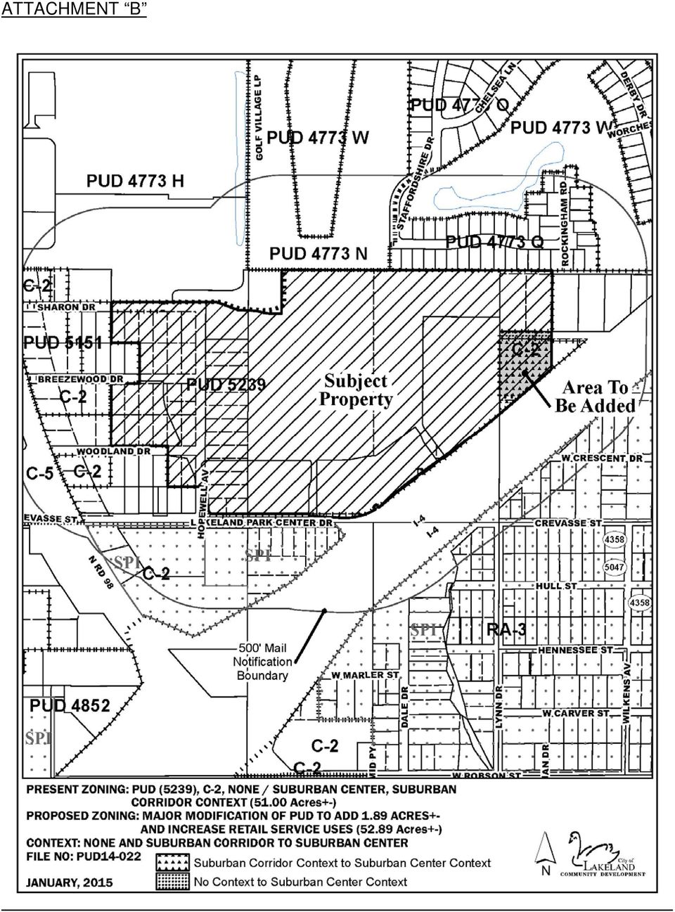
16 ATTACHMENT B
17 ATTACHMENT "C"

18 ATTACHMENT C
19 ATTACHMENT "C-1"

20 ATTACHMENT "C-2"

21 ATTACHMENT "C-3"
22 ATTACHMENT "D-1"
23 ATTACHMENT "D-2"
24 ATTACHMENT "D-3"
25 ATTACHMENT "D-4"
26 ATTACHMENT "E-1"
27 ATTAHCMENT E-1
28 ATTACHMENT "E-2"
29 ATTACHMENT "E-3"
30 ATTACHMENT "E-4"
31 ATTACHMENT "E-5"
32 ATTACHMENT "F"
33 MEMORANDUM DATE: MAY 18, 2015 TO: FROM: SUBJECT: CASE NUMBER: OWNER: APPLICANT: MAYOR & CITY COMMISSION EDWARD LUNZ, CHAIRMAN PLANNING & ZONING BOARD MAJOR MODIFICATION OF PUD ZONING TO ADD APPROXIMATELY 1.89 ACRES, INCREASE THE MAXIMUM RETAIL/SERVICE LIMIT FROM 360,000 TO 378,000 SQUARE FEET AND MODIFY THE MASTER SIGN PLAN ON PROPERTY LOCATED AT 919 LAKELAND PARK CENTER DRIVE PUD RAMCO GATEWAY, LLC JANE L. CALDERA, P.E., TRUCKIN TRAFFIC, LLC P&Z HEARING: JANUARY 21, 2015 P&Z FINAL DECISION: FEBRUARY 17, 2015 LEGAL DESCRIPTION: A legal description of the subject property is included as Attachment A. Background Jane L. Caldera, P.E, requests a major modification of PUD (Planned Unit Development) zoning to add approximately 1.89 acres, increase the maximum retail/service limit from 360,000 to 378,000 square feet and modify the master sign plan on property located at 919 Lakeland Park Center Drive. A map of the subject property is included as Attachment "B." The subject property consists of Lakeland Park Center, a mixed use, regional shopping center located on acres of land located northwest of Interstate 4, east of U.S. Highway 98 North, and north of Lakeland Park Center Drive. As originally approved on May 16, 2011, the PUD allows for 360,000 square feet of retail/service uses, 40,000 square feet of office uses, and a hotel/motel with up to 135 rooms, along with provisions for the limited conversion of development types pursuant to an approved vehicle trip equivalency matrix. Phase I of the shopping center, consisting of approximately 210,000
34 sq. ft. of retail/service uses, was completed in The remainder of the property is currently vacant and awaiting development. The primary purpose of this request is to increase the overall project area from acres to acres by incorporating a 1.64 acre parcel of land located immediately adjacent to the eastern PUD boundaries and through the vacation of a 0.25 acre portion of Union Drive. Both would be incorporated into the area identified on Attachment C as FD- 2 (Future Development Area 2), increasing the size of FD-2 from 5.98 to 7.87 acres. With the additional land, the maximum amount of allowable retail/service uses would be increased from 360,000 sq. ft. to 378,000 sq. ft. As a secondary request, the applicant is seeking revisions to the master sign plan. These changes would amend the conditions pertaining to monument signs on outparcels and allow for three new directory signs at designated locations. The revisions also reflect the as-built location of the Target/tenant pylon sign located at the east end of Lakeland Park Center Drive which has shifted slightly to the west. No additional changes are requested at this time. A revised site development plan and master sign plan are included as Attachments C and E-1. Existing Land Use, FLUM and Zoning/Context of Adjacent Properties Adjacent to Existing Land Use FLUM Zoning/Context North Commercial, singlefamily RAC, RH & RL PUD/SCO & SNH & multi-family residential South Commercial/I-4 ROW IAC/C-2 C-2/SCO East Single-family residential RAC C-2 & None/SCO & vacant land West Single-family & commercial RAC C-2 & None/SCO Discussion The 1.65 acres of land proposed to be incorporated into the PUD has a future land use designation of RAC (Regional Activity Center) and a C-2 (Highway Commercial) zoning classification. The RAC land use designation was applied following annexation with the expectation that it would be acquired by the developer and incorporated as part of the master development plan for the shopping center. The owner of the property, however, refused to sell at the time and the developer only recently acquired the property. Adjacent to this parcel is a portion of improved City right-of-way known as Union Drive. This portion of right-of-way, approximately 0.25 acres in area, encompasses the western 275 feet of Union Drive. With the acquisition of the 1.65 acre parcel, the developer now controls the land abutting both sides of the right-of-way. Concurrent with this request, the
35 applicant will be requesting the vacation of this portion of the right-of-way for the purposes of incorporating it into the parcel identified as FD-2 on the revised Attachment C. Altogether, the addition of these two parcels will add a total of 1.89 acres of land to the existing PUD. The additional land will be used to accommodate the off-street parking, landscaping, and stormwater retention necessary to develop FD-2. To reflect the additional acreage, the applicant has requested that the maximum allowable development limit for retail/service uses, as specified by Condition B.1. (Development Limits), be increased from 360,000 to 378,000 square feet. This change is consistent with the previous zoning which allocated retail/service uses at an intensity of 10,000 sq. ft. of building area per acre of land. Secondarily, the applicant is requesting changes to the master sign plan, Attachment E- 1. The first change would limit the placement of monument signs currently permitted on the eight outparcels and update the master sign plan to reflect the actual location of the Tenant Pylon Sign (Sign 5), as-built. The second change would allow for three new directory signs in specific locations, as depicted as signs A, B, and C on the revised Attachment E-1. The current PUD allows for two monument signs per outparcel, either Type 3 or Type 4, with no restrictions on location. With the proposed change, only one monument sign per outparcel will be allowed adjacent to the Lakeland Park Center frontage. Directory signs normally must be setback a minimum of 30 from any public right-of-way. However, due to a combination of topography and the public/private nature of the local street network, this requirement is not practical in this particular circumstance. An allowance for directory signs in the locations depicted on Attachment E-1 will improve the efficiency of traffic circulation internally and encourage the use of two newly created cross access driveways. These driveways provide a direct connection to the Shoppes of Lakeland shopping center to the north. In all other respects, such signs will comply with the requirements for directory signs as specified by Section 4.9 of the Land Development Code. The Community Development Department and the Board reviewed this request for compliance with Lakeland Comprehensive Plan: and it is our opinion that the request is consistent with the Comprehensive Plan. All roadway levels of service are acceptable. Other essential services are presently available to provide concurrency for the proposed use. Actual construction is subject to final concurrency determinations at the time of site plan review. The Community Development Department reviewed this request and recommended the modification of PUD zoning. Letters of notification were mailed to 90 property owners within 500 feet of the subject property and no objections were received. This recommendation was approved by a 6-0 vote of the Board.
36 Recommendation It is recommended that the request for a major modification of PUD zoning, as described above and in Attachments A, B, C, C-1, C-2, C-3, D-1, D-2, D-3, D-4, E-1, E-2, E-3, E-4, E-5, and "F," be approved, subject to the following conditions: Note: The Suburban Center context district will be applied to those areas shown on Attachment B. A. Permitted Uses: 1. A regional retail shopping center with outparcels, including those uses permitted in the C-5 (Regional Center Commercial) zoning district, except that the following principal uses shall be prohibited: Funeral homes and crematoriums Mobile home sales, rental and service agencies Motor vehicle and boat sales and rental Outdoor commercial recreation Regulated uses Retail marine sales and service (Marine accessory stores, which may include the incidental sales and service of watercraft, are permitted.) 2. Overnight boarding of animals and veterinary clinics are permitted as an accessory use provided that such uses are (a) located within a completely enclosed building and (b) incidental and accessory to a pet supply store as the principal use. 3. In order to regulate the amount of diverted trips that enter the project site from I-4 via US 98, no more than four of the outparcels shall include drivethrough facilities, except, however, that banks and other financial institutions may have drive-through facilities which shall not count toward the four-parcel limit. B. Development Limits: 1. Maximum Allowed Development by Type, subject to conversion in (2) below: Retail/Service: Office: Hotel/Motel: 360,000378,000 square feet 40,000 square feet 135 rooms 2. Conversion of Development Types: The amount of development may be converted from one type to another without requiring a change to this PUD in accordance with the following Vehicle Trip Equivalency Matrix, except that
37 no more than 20,000 square feet of the allowed office uses may be converted. VEHICLE TRIP EQUIVALENCY MATRIX CHANGE TO RETAIL/ SERVICE (1,000 Sq.Ft.) OFFICE (1,000 Sq.Ft.) HOTEL/ MOTEL (Rooms) C H A N G E F R O M RETAIL/SERVICE (1,000 Sq.Ft.) OFFICE (1,000 Sq.Ft.) HOTEL/MOTEL (Rooms) EXAMPLE #1: To convert from retail to hotel, multiply the number of desired hotel rooms by the retail equivalency factor to get the number of equivalent reduction in retail square footage. 50 hotel rooms x (retail equiv. factor) = x 1,000 = 10,300 sq. ft. retail To add 50 hotel rooms, reduce retail by 10,300 sq. ft. EXAMPLE #2: To convert from hotel to office, multiply the desired office square footage by the hotel equivalency factor to get the number of equivalent hotel room reduction. 20,000 sq. ft. office x (hotel equiv. factor) = 46,600 / 1,000 = 46.6 hotel rooms To add 20,000 sq. ft. office, reduce hotel by 47 rooms C. Site Development Plan: The project shall be developed in substantial accordance with the site development plan included as Attachment "C. With the approval of the Director of Community Development, minor adjustments can be made to lot configuration, structure configuration and parking configuration at the time of final site plan review without requiring a change to this PUD. In the event that a station site for the new Florida High-Speed Rail system is selected in the north central Lakeland area, the developer shall agree to cooperate with the City and other stakeholders regarding complementary uses or layout scenarios to support this new facility and transportation service to the maximum extent that is feasible. However, the obligation for the developer to cooperate shall not reduce any entitlements granted by this PUD. D. Development StandardsRegulations: In accordance with C-5/Suburban Center zoning sub-district standardsregulations, except as below or as otherwise provided herein. For purposes of this ordinance, unified development shall mean all buildings identified as Major, Retail and Anchor in Attachment C and the associated parking areas. Outparcel shall mean all parcels identified as Out Parcel or Future Development Area in Attachment C. 1. Minimum Unified Development Building Bulk StandardsRegulations:
38 Minimum building setbacks: In accordance with Attachment C. 2. Minimum Outparcel Building Bulk StandardsRegulations: a. Minimum building setbacks: In accordance with C-2/Suburban Center (Highway Commercial) zoning sub-district standardsregulations except that there shall be no minimum setbacks from property lines which are not boundaries of the unified development. b. Maximum building height: Retail uses: 40 feet. E. Architectural Design Standards: Hotels/motels and office uses: 44 feet or 1 foot in height for each 1 foot in setback from boundaries of unified development, whichever is greater, to a maximum of 75 feet measured to the eve or cornice line. 1. Unified Development Buildings: It is the intent of this PUD to adopt uniform architectural design standards in order to ensure a project that is harmonious in form and appearance. Buildings identified as Anchor, Major and Retail buildings in Attachment C shall be constructed with architectural detailing in substantial accordance with architectural elevations included as Attachments "D-1," "D-2," "D-3," and "D-4" dated October 13, 2010, provided, however, that building façades facing sidewalks or pedestrian ways shall have a vertical variation a minimum of every 30 feet measured horizontally along the face of the building. Such vertical variation may be provided by the addition of fenestration, columns, pilasters, wall plane projections/recesses or other architectural elements. Architectural elements may include shutters, awnings, canopies, porticos, trellises, pergolas, raised planters, or other elements approved by the Director of Community Development. With the approval of the Director of Community Development, minor adjustments can be made to the architectural elevations at the time of final site plan review without requiring a change to this PUD. This standard shall not apply to the north-facing facades of Major A through Major F. 2. Outparcel Buildings: a. All building facades facing streets, private drives or customer parking areas shall include fenestration, architectural relief or both so that no portion of a façade shall have a blank area greater than 24 feet in
39 width measured horizontally along the face of the building. Architectural relief may be provided by changes in materials or textures, changes in volume or wall plane, and the use of awnings, canopies, porticos, pilasters or similar architectural elements. Architectural elements may include trellises, pergolas, raised planters, or other elements approved by the Director of Community Development. b. All building facades facing streets, private drives or customer parking areas shall provide foundation landscaping. A minimum of fifty percent of the façade width, measured horizontally along the face of the building, shall include landscaping adjacent to the foundation. Foundation landscaping shall consist of shrubs and ground cover plants installed so that 100 percent ground coverage is achieved within one year of planting. Planting shall be in accordance with Sub- Section of the Land Development Code. 3. Service and loading dock areas that are visible from a street, private drive or customer parking area, shall be screened by a wall or fence compatible with the architecture of the principal structure. 4. Mechanical equipment at ground level that is visible from any surface street, private drive or customer parking area shall be screened from view by a wall or fence using materials compatible with the architecture of the principal structure. Alternatively, a hedge may be used in lieu of a screening wall provided that the hedge is installed in such a manner as to provide ninety percent view blockage within three years of installation. Roof-mounted mechanical equipment that is visible from any surface street, private drive or customer parking area shall be screened from view by architectural elements that are an integral part of the building design. 5. Except for street lights within public rights-of-way, decorative streetscape lampposts and decorative accent wall fixtures as indicated in Attachments D-1, D-2, D-3, and "D-4" all outdoor lighting fixtures shall be of the "fully shielded" type such that the light emitting, distributing, reflecting and refracting components of the light fixture (lamp, lens, reflective surfaces, etc.) shall not extend beyond the opaque housing of the fixture. Lighting of overhangs, canopies and awnings shall be designed such that the light emitting, distributing, reflecting and refracting components of the light fixture (lamp, lens, reflective surfaces, etc.) shall not extend below the lowest portion of the overhang, canopy or awning or any associated surround, skirt or entablature. F. Landscaping:
ORDINANCE NO. 21-2014 (As Amended)
") ORDINANCE NO. 21-2014 (As Amended) To Amend the Official Zoning Map of the City of Worthington, Ohio, to Change Zoning of Certain Land from C-3, Institutions and Offices to PUD, Planned Unit Development
ORDINANCE NO. 21-2014 (As Amended) To Amend the Official Zoning Map of the City of Worthington, Ohio, to Change Zoning of Certain Land from C-3, Institutions and Offices to PUD, Planned Unit Development
CITY COUNCIL PACKET MEMORANDUM
 CITY COUNCIL PACKET MEMORANDUM DOCUMENT: Final Plan and Final Plat SUBJECT: City Center Lenexa The Domain at City Center CONTACT PERSON: Beccy Yocham, Director of Community Development DATE: December 3,
1161.01 CONFORMITY WITH PLANS; DRAINAGE.
 CHAPTER 1161 Subdivision Requirements 1161.01 Conformity with plans; drainage 1161.07 Easements 1161.02 Trees 1161.08 Streets 1161.03 Subdivision name 1161.09 Blocks 1161.04 Street names 1161.10 Lots 1161.05
WESTFIELD-WASHINGTON ADVISORY PLAN COMMISSION December 7, 2015 1512-SPP-24 & 1512-ODP-24
 Petition Number: Subject Site Address: Petitioner: Request: East side of Oak Road, north of 151 st Street Langston Development Co. Primary Plat and Overall Development Plan amendment review for Mapleridge
d. Building permits may only be approved if consistent with the approved development plan and land division for all units with common walls.
 Section 20.920.060 Tier 2 Infill Standards. In addition to the Tier 1 standards and incentives, Tier 2 infill parcels and land divisions and the subsequent development on those Tier 2 infill parcels shall
PROFFER STATEMENT REZONING TLZM 2013-0001 LEEGATE November 1, 2013
 PROFFER STATEMENT REZONING TLZM 2013-0001 LEEGATE November 1, 2013 Leegate LLC and Stanley Martin Companies, LLC, owner and applicant, (the Applicant ) of certain property described as Loudoun County Tax
Industrial Suburban District Regulations City of St. Petersburg City Code Chapter 16, Land Development Regulations
 16.20.110 - Industrial Suburban District ( IS ) Figure REFERENCE Typical Buildings in the IS District Figure REFERENCE Site Plan of a typical development in the IS District Sections: 16.20.110.1 Composition
BEACON AVENUE URBAN RENEWAL PROJECT
 BEACON AVENUE URBAN RENEWAL PROJECT City of Jersey City Adopted May, 1976 Block and Lot Updates August 6, 2012 Amended September 13, 2012 DIVISION OF CITY PLANNING Beacon Avenue Urban Renewal Project Table
BLOCK 400 PLANNED COMMUNITY DISTRICT
 BLOCK 400 PLANNED COMMUNITY DISTRICT Newport Center December 1983 Newport Beach, California Ordinance 88-119 Adopted December 12, 1988 Amendment No. 672 Resolution No. 95-115 Adopted October 9, 1995 Amendment
County of San Diego, Planning & Development Services SECOND DWELLING UNIT
 County of San Diego, Planning & Development Services ZONING DIVISION The Zoning Ordinance, Section 6156.x, allows the addition of a second dwelling unit to those properties zoned to allow the Family Residential
Preliminary Plan Application and Checklist
 ALL APPLICATIONS ARE DUE AT 12:00 NOON ON THE FILING DATE Office Use Only PRELIMINARY / REVISED PRELIMINARY PLAN $300.00 Fee Paid: $ Date Paid: ALL FIELDS HIGHLIGHTED IN RED ARE REQUIRED FIELDS Case No.:
CHAPTER 23 Wireless Communication Facilities
 CHAPTER 23 Wireless Communication Facilities Section 23.1 Purpose It is the general purpose and intent of this Section to comply with the requirements of the Federal Telecommunications Act of 1996, as
ORDINANCE 2005-09 NOW, THEREFORE, BE IT ORDAINED BY THE CITY OF BRENTWOOD, TENNESSEE, AS FOLLOWS:
 ORDINANCE 2005-09 AN ORDINANCE OF THE CITY OF BRENTWOOD, TENNESSEE PROVIDING THAT THE CODE OF ORDINANCES OF THE CITY OF BRENTWOOD BE AMENDED BY REVISING SECTION 78-10, PROVIDING FOR MINIMUM STANDARDS FOR
Topic 2 11/28/2012 Blocks & Street Network
 TOPIC 2 Blocks & Street Network Implementation Note: 1. Some recommendations are summarized in the tables herein. For complete recommendation language, please see the. 2. Recommendations referenced in
Comparison Business District (CB)
") Section 13.00 Preamble The Comparison Business (CB) Districts are intended to provide for a wide range of shopping needs for the Township and surrounding region. The CB District may contain shopping facilities
Section 13.00 Preamble The Comparison Business (CB) Districts are intended to provide for a wide range of shopping needs for the Township and surrounding region. The CB District may contain shopping facilities
PLANNING DIVISION STAFF REPORT February 23, 2015. Summary. Background Information PREPARED FOR THE PLAN COMMISSION. Legistar File ID # 36810
 PLANNING DIVISION STAFF REPORT PREPARED FOR THE PLAN COMMISSION Project Address: Application Type: Legistar File ID # 36810 Prepared By: Summary Conditional Use Timothy M. Parks, Planning Division Report
Planning and Zoning Commission Johnston, Iowa June 29, 2015
 ITEM NO. 15-19 Planning and Zoning Commission Johnston, Iowa June 29, 2015 SUBJECT: Consider recommending approval of the Final Plat for Crosshaven Plat 6 subdividing 28.28 acres into 47 single family
FILE NO.: Z-6915-C. Gamble Road Short-form PCD and Land Alteration Variance Request
 FILE NO.: Z-6915-C NAME: Gamble Road Short-form PCD and Land Alteration Variance Request LOCATION: Located on the Northwest corner of Chenal Parkway and Gamble Road DEVELOPER: Davis Properties P.O. Box
Fast Track A Successful Redevelopment: The Palm Beach Outlets Story
 Fast Track A Successful Redevelopment: The Palm Beach Outlets Story SPEAKERS Rick Greene, AICP City of West Palm Beach Brian Seymour, Esq. Gunster Ken Tuma, PE UDKS Josh Long, AICP Gunster Grand Opening
TO WHOM IT MAY CONCERN: YOU ARE HEREBY NOTIFIED THAT AN ORDINANCE ENTITLED:
 TO WHOM IT MAY CONCERN: YOU ARE HEREBY NOTIFIED THAT AN ORDINANCE ENTITLED: AN ORDINANCE SUPPLEMENTING AND AMENDING VOLUME II CHAPTER 148 ENTITLED LAND DEVELOPMENT OF THE CODE OF THE TOWNSHIP OF READINGTON,
BOROUGH COUNCIL BOROUGH OF SELLERSVILLE BUCKS COUNTY, PENNSYLVANIA ORDINANCE NO. 685
 BOROUGH COUNCIL BOROUGH OF SELLERSVILLE BUCKS COUNTY, ENNSYLVANIA ORDINANCE NO. 685 "MR-1 District Ordinance and Map Amendment" AN ORDINANCE AMENDING THE CODE OF THE BOROUGH OF SELLERSVILLE, CHATER 160
AREA: 2.37 acres NUMBER OF LOTS: 1 FT. NEW STREET: 0 LF. Single-family, Non-conforming machine shop
 FILE NO.: Z-8958 NAME: Rock Structure Repair Short-form PID LOCATION: Located at 8024 Stanton Road DEVELOPER: Rock Structure Repair Attn. Rudy Gutierrez 3 Kipling Court Little Rock, AR 72209 ENGINEER:
REPORT OF THE PLANNING AND DEVELOPMENT DEPARTMENT FOR APPLICATION FOR REZONING ORDINANCE 2015-0183 TO PLANNED UNIT DEVELOPMENT APRIL 9, 2015
 AWH REPORT OF THE PLANNING AND DEVELOPMENT DEPARTMENT FOR APPLICATION FOR REZONING ORDINANCE 2015-0183 TO PLANNED UNIT DEVELOPMENT APRIL 9, 2015 The Planning and Development Department hereby forwards
5 March 12, 2014 Public Hearing
 5 March 12, 2014 Public Hearing APPLICANT: MOORE FARM, L.L.L.P. PROPERTY OWNER: MOORE FARM L.L.L.P. STAFF PLANNER: Kevin Kemp REQUEST: Change of Zoning (B-1A Limited Community Business to Conditional B-2
Mayor Laurel Lunt Prussing and Members of the City Council William R. Gray, P.E., Public Works Director DATE: March 10, 2016
 CITY OF URBANA, ILLINOIS DEPARTMENT OF PUBLIC WORKS ADMINISTRATION M E M O R A N D U M TO: FROM: Mayor Laurel Lunt Prussing and Members of the City Council William R. Gray, P.E., Public Works Director
FILE NO.: Z-8403. LOCATION: Located on the Northeast and Southeast corners of West 12 th Street and Dennison Street
 FILE NO.: Z-8403 NAME: Glason Short-form POD LOCATION: Located on the Northeast and Southeast corners of West 12 th Street and Dennison Street DEVELOPER: Dennis Glason c/o the Law Office of Simmons S.
First American Title Insurance Company. National Commercial Services
 Page Number: 1 National Commercial Services 1850 Mt. Diablo Blvd., Suite 300 Walnut Creek, CA 94596 Lawrence Dunnigan Port Of Oakland 530 Water Street Oakland, CA 94607 Phone: (510)627-1100 Escrow Officer:
Chapter 7 ZONING PLAN
 Chapter 7 ZONING PLAN Introduction This Chapter opens with a general description of a zoning plan. It is followed by a brief explanation of the relationship between this Growth Management Plan and the
Kirkland Zoning Code 113.25
 Kirkland Zoning Code 113.25 Chapter 113 COTTAGE, CARRIAGE AND TWO/THREE-UNIT HOMES Sections: 113.05 User Guide 113.10 Voluntary Provisions and Intent 113.15 Housing Types Defined 113.20 Applicable Use
City Code of ANN ARBOR, MICHIGAN Chapter 55 Zoning
 ARTICLE II. USE REGULATIONS 5:10.2. R1A, R1B, R1C, R1D single family dwelling district (1) Intent. (a) These single family residential districts are designed to provide an environment of predominantly
Street Trees Ordinance.
 Street Trees Ordinance. ORDINANCE NO. 12-08 AN ORDINANCE AMENDING CHAPTER 150 OF THE NORTH LIBERTY CODE OF ORDINANCES TO IMPLEMENT CHANGES TO TREES IN RIGHT-OF-WAY BE IT ORDAINED BY THE CITY COUNCIL OF
The Urban Renewal Authority of Pueblo
 The Urban Renewal Authority of Pueblo The Urban Renewal Plan for the Saint Charles Industrial Park Urban Renewal Project Area Page 1 I. DEFINITIONS The terms used in this Urban Renewal Plan shall have
12 February 8, 2012 Public Hearing APPLICANT:
 12 February 8, 2012 Public Hearing APPLICANT: PROPERTY OWNER: VIRGINIA BEACH ASSOCIATES, LC REQUEST: Conditional Change of Zoning (I-1 to Conditional A-36) STAFF PLANNER: Faith Christie ADDRESS / DESCRIPTION:
VILLAGE OF RIDGEWOOD ORDINANCE NO. 3491
 VILLAGE OF RIDGEWOOD ORDINANCE NO. 3491 AN ORDINANCE OF THE VILLAGE OF RIDGEWOOD CHANGING THE ZONE CLASSIFICATION OF CERTAIN PROPERTIES FROM THE C ZONE DISTRICT TO A NEW C-R ZONE DISTRICT AND ADOPTING
CITY OF SURREY BY-LAW NO. 17707. A by-law to amend Surrey Zoning By-law, 1993, No. 12000, as amended
 CITY OF SURREY BY-LAW NO. 17707 A by-law to amend Surrey Zoning By-law, 1993, No. 12000, as amended THE CITY COUNCIL of the City of Surrey, in open meeting assembled, ENACTS AS FOLLOWS: 1. Surrey Zoning
Block A-24 REDEVELOPMENT PLAN
 Block A-24 REDEVELOPMENT PLAN TABLE OF CONTENTS I. Introduction II. Description of Project Area A. Existing Uses and Conditions B. Boundary Description III. Goals and Objectives IV. Redevelopment Activities
City of Douglas Commercial Building Permit Site Application
 City of Douglas Commercial Building Permit Site Application *Complete the following information including a complete site plan and floor plan. *Incomplete information may result in delay and/or rejection
CITY OF WEST PALM BEACH ZONING BOARD OF APPEALS Meeting Date: February 6, 2014 Zoning Board of Appeals Case No. 3302
 CITY OF WEST PALM BEACH ZONING BOARD OF APPEALS Meeting Date: February 6, 2014 Zoning Board of Appeals Case No. 3302 1950 Golden Lakes Blvd. Class B Special Use Permit Location Aerial I. REQUEST Site is
January 25, 2005. Ivest Associates c/o Stanhope Johnson P. O. Box 9905 Greensboro, NC 27030 RE: ZONING MAP AMENDMENT W-2747. Dear Mr.
 GAMBLE DR 730 January 25, 2005 Ivest Associates c/o Stanhope Johnson P. O. Box 9905 Greensboro, NC 27030 RE: ZONING MAP AMENDMENT W-2747 Dear Mr. Johnson: The attached report of the Planning Board to the
BEST PRACTICES. Smart Transportation is a key concept for the Paoli Roadway Improvement Project.
 Smart Transportation Smart Transportation is a key concept for the Paoli Roadway Improvement Project. PennDOT s Smart Transportation Guidebook (2008) outlines a comprehensive approach to transportation
TOWN OF DAVIE TOWN COUNCIL AGENDA REPORT
 TOWN OF DAVIE TOWN COUNCIL AGENDA REPORT TO: Mayor and Councilmembers FROM/PHONE: Mark Kutney, AICP, Development Services Director/(954) 797-1101 Prepared by Annie Feng, Planner II SUBJECT: Resolution
Appendix N: Bicycle Parking Ordinance
 Appendix N: Bicycle Parking Ordinance ORDINANCE NO. #1-13. AN ORDINANCE AMENDING CHAPTER 40 OF THE MUNICIPAL CODE OF THE CITY OF DAVIS TO ADD ARTICLE 40.25A ESTABLISHING BICYCLE PARKING STANDARDS WHEREAS,
CITY OF WOODBURY ORDINANCE NO. 1803
 CITY OF WOODBURY ORDINANCE NO. 1803 AN ORDINANCE OF THE CITY OF WOODBURY, WASHINGTON COUNTY, MINNESOTA PROVIDING THAT THE CITY CODE BE AMENDED BY CHAPTER 24, ZONING, ARTICLE III - ZONING DISTRICTS AND
ORDINANCE NO. 4521 THE CITY COUNCIL OF ALEXANDRIA HEREBY ORDAINS:
 ORDINANCE NO. 4521 AN ORDINANCE to amend and reordain Section 6-800 (KING STREET OUTDOOR DINING OVERLAY ZONE), of Article VI (SPECIAL AND OVERLAY ZONES), of the City of Alexandria Zoning Ordinance, in
Staff Report General Development Plan/Master Plan Aldermanic District: 1 County Commission District: 2 MPC File No. 16-000526-PLAN February 23, 2016
 Staff Report General Development Plan/Master Plan Aldermanic District: 1 County Commission District: 2 MPC File No. 16-000526-PLAN February 23, 2016 1101 Bull Street One West Park Avenue 1107 Bull Street
 Walkable Communities Florida Department of Transportation State Safety Office Pedestrian and Bicycle Program April 1995 www.dot.state.fl.us/safety Twelve Steps for an Effective Program Page 1 Twelve Steps
City of Colleyville Community Development Department. Site/Landscape Plan Application Packet
 City of Colleyville Community Development Department Site/Landscape Plan Application Packet Development Application Fees City of Colleyville 100 Main Street Colleyville TX 76034 817.503.1050 Zoning Zoning
28.0 Development Permit Area #2 (Neighbourhood District)
") 28.0 Development Permit Area #2 (Neighbourhood District) Goals and Objectives To provide a guide for infill and new development in the Neighbourhood District. To outline the nature, form and character
28.0 Development Permit Area #2 (Neighbourhood District) Goals and Objectives To provide a guide for infill and new development in the Neighbourhood District. To outline the nature, form and character
LAND DEVELOPMENT STAFF REPORT AND RECOMMENDATION
 SP-13-03 Revised: 12/17/14 Exhibit "A 01/26/15 Date: December 12, 2014 LAND DEVELOPMENT STAFF REPORT AND RECOMMENDATION I. Project Description: Project: Kid s College Greenacres Campus Petitioner: Carlos
INTRODUCTION TO ZONING DISTRICT REGULATIONS
 INTRODUCTION TO ZONING DISTRICT REGULATIONS Classification of Zoning Districts Zoning districts in Dorchester County are categorized as Suburban Urban, Suburban Transition, or Rural. These districts are
BOROUGH OF OAKLAND COUNTY OF BERGEN STATE OF NEW JERSEY ORDINANCE 13-CODE-685
 BOROUGH OF OAKLAND COUNTY OF BERGEN STATE OF NEW JERSEY ORDINANCE 13-CODE-685 AN ORDINANCE TO AMEND, SUPPLEMENT AND REVISE THE CODE OF THE BOROUGH OF OAKLAND, LAND USE, CHAPTER 59 ENTITLED LAND USE AND
Architectural Design Standards Example Guide DESIGN STANDARDS EXAMPLE GUIDE
 Architectural Design Standards Example Guide DESIGN STANDARDS EXAMPLE GUIDE Commercial, Professional Office, and Public Facility Developments Purpose This Guide offers examples to clarify and explain the
DESIGN REVIEW CHECKLIST Chapter 6 Special Consideration Design Guidelines
 DESIGN REVIEW CHECKLIST Chapter 6 Special Consideration Design Guidelines A. Offices a. Office buildings should be built to the minimum required setback. b. Surface parking should be located towards the
ORDINANCE NO. 2013 -
 ORDINANCE NO. 2013 - AN ORDINANCE OF BREVARD COUNTY, FLORIDA AMENDING CHAPTER 62, LAND DEVELOPMENT REGULATIONS SECTION 62-2891, LOT DRAINAGE, AND CHAPTER 22 BUILDINGS AND BUILDING REGULATIONS, SECTION
APPENDIX F RIGHTS-OF-WAY PRESERVATION GUIDELINES
 Los Angeles County Metropolitan Transportation Authority (Metro) 2009 Transportation Improvement Program Call for Projects APPENDIX F RIGHTS-OF-WAY PRESERVATION GUIDELINES Los Angeles County Metropolitan
NOW, THEREFORE, BE IT ORDAINED BY THE CITY COUNCIL OF THE CITY OF KYLE, TEXAS, THAT:
 ORDINANCE NO. AN ORDINANCE OF THE CITY OF KYLE, TEXAS, AMENDING CHAPTER 29, SIGN STANDARDS AND PERMITS OF THE CITY S CODE OF ORDINANCES RELATIVE TO PERMITTING EXISTING OFF-PREMISE COMMERCIAL BILLBOARDS
3 September 9, 2015 Public Hearing
 3 September 9, 2015 Public Hearing APPLICANT: PI TELECOM INFRASTRUCTURE T, LLC PROPERTY OWNER: JSW HOLDINGS, LLC STAFF PLANNER: Carolyn A.K. Smith REQUEST: Conditional Use Permit (communications tower-monopole)
Tier 1 Strategies. WV Route 14 Corridor Management Plan
 1.1 1.2 1.3 1.4 Signal timing optimization system improvements. Improve geometry traffic control at high crash intersections. Construct intersection capacity improvement projects. Widen longer sections
City of Valdosta Land Development Regulations. Table of Contents
 TITLE 1 ADMINISTRATION Chapter 102 General Provisions 102-1 Title 102-2 Purpose 102-3 Authority 102-4 Jurisdiction 102-5 Application of Ordinance 102-6 Relationship to Existing Ordinances 102-7 Powers
HARDWICK TOWNSHIP WARREN COUNTY, NEW JERSEY
 HARDWICK TOWNSHIP WARREN COUNTY, NEW JERSEY AN ORDINANCE TO AMEND CHAPTER XIII OF THE REVISED GENERAL ORDINANCES BEING THE LAND DEVELOPMENT ORDINANCE OF THE TOWNSHIP OF HARDWICK TOWNSHIP IN ORDER TO ADOPT
VILLAGE OF PLEASANT PRAIRIE COMMERCIAL COMMUNICATION PERMIT
 VILLAGE OF PLEASANT PRAIRIE COMMERCIAL COMMUNICATION PERMIT CLASS 1 COLLOCATION New Commercial Communication Structure Substantial Modification Please check one of the following: CLASS 2 COLLOCATION OTHER
D3 April 8, 2015 Public Hearing
 D3 April 8, 2015 Public Hearing APPLICANT AND PROPERTY OWNER: ASSEMBLY OF YAH, INC. STAFF PLANNER: Kevin Kemp REQUEST: Conditional Use Permit (Religious Facility - church) ADDRESS / DESCRIPTION: 5151 Locke
Chapter 19.45 O-R-D OFFICE RESEARCH PARK AND DEVELOPMENT ZONE. 19.45.010 Purpose of provisions. Title 19 ZONING. 19.45.010 Purpose of provisions.
 Title 19 ZONING Chapter 19.45 O-R-D OFFICE RESEARCH PARK AND DEVELOPMENT ZONE 19.45.010 Purpose of provisions. 19.45.020 Design and site plan approval. 19.45.030 Permitted uses. 19.45.040 Conditional uses.
Division 51-4.400. Yard, Lot, and Space Regulations.
 Division 51-4.400. Yard, Lot, and Space Regulations. SEC. 51-4.401. MINIMUM FRONT YARD. (a) General provisions. (1) Required front yards must be open and unobstructed except for fences. Except as otherwise
TRANSFER AND CONVEYANCE STANDARDS OF THE FRANKLIN COUNTY AUDITOR AND THE FRANKLIN COUNTY ENGINEER AS ADOPTED UNDER OHIO REVISED CODE SECTION 319.
 TRANSFER AND CONVEYANCE STANDARDS OF THE FRANKLIN COUNTY AUDITOR AND THE FRANKLIN COUNTY ENGINEER AS ADOPTED UNDER OHIO REVISED CODE SECTION 319.203 EFFECTIVE JULY 1, 1996 AMENDED JULY 14, 1997 AMENDED
ORDINANCE NO. AN ORDINANCE
 150201 (Published ) #R/W-2015-4 ORDINANCE NO. AN ORDINANCE vacating TRACT 1 - All that part of the Southwest Quarter of Section 6, Township 11 South, Range 24 East, and all that part of vacated Lots 19,
SCHEDULE 16 TO THE SPECIAL USE ZONE. Shown on the planning scheme map as SUZ16. BALLARAT RAILWAY STATION PRECINCT. Purpose
 SCHEDULE 16 TO THE SPECIAL USE ZONE Shown on the planning scheme map as SUZ16. BALLARAT RAILWAY STATION PRECINCT Purpose To facilitate the revitalisation of the Ballarat Station Precinct in accordance
City of Surrey PLANNING & DEVELOPMENT REPORT File: 7908-0284-00
 City of Surrey PLANNING & DEVELOPMENT REPORT PROPOSAL: Planning Report Date: March 30, 2009 Development Permit in order to permit the development of a new concrete bagging and storage facility on the site
SPECIAL USE PERMIT 22-01. JCSA Groundwater Treatment Facility Staff Report for the November 5, 2001, Planning Commission Public Hearing
 SPECIAL USE PERMIT 22-01. JCSA Groundwater Treatment Facility Staff Report for the November 5, 2001, Planning Commission Public Hearing This report is prepared by the James City County Planning Division
Lincoln Downtown Master Plan Update
 Lincoln Downtown Master Plan Update Table of Contents Executive Summary........................................... 1 Complete Streets Framework.................................... 3 Promenade Creating
MIAMI 21 AS ADOPTED MAY 2010
 TABLE OF CONTENTS 5.1 Generally 5.2 Natural Transect Zones (T1) and Rural Transect Zones (T2) 5.3 Sub-Urban Transect Zones (T3) 5.4 General Urban Transect Zones (T4) 5.5 Urban Center Transect Zones (T5)
AREA: 0.16 acres NUMBER OF LOTS: 1 FT. NEW STREET: 0 LF
 FILE NO.: Z-9020 NAME: Hometown Tax Service Short-form PD-O LOCATION: Located at 3008 West 12 th Street DEVELOPER: Mark Green 65 Westfield Loop Little Rock, AR 72210 SURVEYOR: Kittler-Roberts Group, LLP
BOARD OF ADJUSTMENT STAFF REPORT. BOA File No. 3786 1515 West Avenue- Multifamily Building
 MIAMI BEACH PLANNING DEPARTMENT FROM: DATE: RE: BOARD OF ADJUSTMENT STAFF REPORT Thomas R. Mooney, AIC~ Planning Director December 4, 2015 Meeting BOA File No. 3786 1515 West Avenue- Multifamily Building
AN ORDINANCE APPROVING THE PETITION OF HDH, LLC AND STL BROADWAY HOTEL, LLC AS OWNERS OF CERTAIN REAL PROPERTY, TO ESTABLISH A COMMUNITY IMPROVEMENT
 BOARD BILL # INTRODUCED BY ALDERWOMAN YOUNG AN ORDINANCE APPROVING THE PETITION OF HDH, LLC AND STL BROADWAY HOTEL, LLC AS OWNERS OF CERTAIN REAL PROPERTY, TO ESTABLISH A COMMUNITY IMPROVEMENT DISTRICT,
ARTICLE 305. PD 305. Cityplace
 ARTICLE 305. PD 305. Cityplace SEC. 51P-305.101. LEGISLATIVE HISTORY. PD 305 was established by Ordinance No. 20546, passed by the Dallas City Council on January 10, 1990. Ordinance No. 20546 amended Chapters
COMMUNITY APPEARANCE STANDARDS
 Article 25 COMMUNITY APPEARANCE STANDARDS 25.01 Applicability 25.01.01 This Article is applicable to the publicly visible portions of building elements, as defined herein. A. An element of a building shall
ORDINANCE NO. 1130. Ordinance No. 1130 - Page 1 of 7. Language to be added is underlined. Language to be deleted is struck through.
 ORDINANCE NO. 1130 AN ORDINANCE OF THE CITY OF OKEECHOBEE, FLORIDA, PROVIDING FOR AMENDMENTS TO PART II OF THE CODE OF ORDINANCES, SUBPART B-LAND DEVELOPMENT REGULATIONS; PROVIDING FOR AMENDMENTS CHAPTER
Brevard County Public Works Finance and Contracts Administration
 Brevard County Public Works Finance and Contracts Administration Public Works Survey & Mapping Division Review Check Sheet for Land Acquisition, Drainage, Roadway and Pedway Expansion, Asbuilts, Maintenance
Section 801 Driveway Access Onto Public Right-of-Ways
 Section 801:00 Section 801 Driveway Access Onto Public Right-of-Ways Section 801:00. Definitions. The following words and terms, when used in this Article, shall have the following meanings, unless the
HARRIS TEETER AT LADY S ISLAND CITY OF BEAUFORT DRB CONCEPTUAL PROJECT NARRATIVE Submittal Date: September 2, 2015 Meeting Date: September 10, 2015
 HARRIS TEETER AT LADY S ISLAND CITY OF BEAUFORT DRB CONCEPTUAL PROJECT NARRATIVE Submittal Date: September 2, 2015 Meeting Date: September 10, 2015 PROPOSED REDEVELOPMENT The project consists of demolishing
UDRB APPLICATION URBAN DEVELOPMENT REVIEW BOARD
 UDRB APPLICATION CITY OF MIAMI VISION STATEMENT: To Be an International City that Embodies Diversity, Economic Opportunity, Effective Customer Service and a Highly Rated Quality of Life OBJECTIVE: The
Texas Case Studies in Access Management. Ed Hard, TTI
 Texas Case Studies in Access Management Ed Hard, TTI 8 th National Conference on Access Management August 15, 2006 Presentation Overview TxDOT Arterial Widenings, College Station, TX Processes for Median
AGENDA ITEM SUMMARY FORT COLLINS CITY COUNCIL 11
 DATE: September 4, 2012 STAFF: Patrick Rowe, Terry Tyrell Helen Matson AGENDA ITEM SUMMARY FORT COLLINS CITY COUNCIL 11 SUBJECT Second Reading of Ordinance No. 080, 2012, Authorizing the Acquisition by
TOWN BOARD OF THE TOWN OF NORTH SALEM WESTCHESTER COUNTY, NEW YORK LOCAL LAW # OF THE YEAR 2012
 TOWN BOARD OF THE TOWN OF NORTH SALEM WESTCHESTER COUNTY, NEW YORK LOCAL LAW # OF THE YEAR 2012 CHAPTER 250, ZONING ORDINANCE AMENDMENTS - PD-CCRC DISTRICT Section 1. Purpose: The purpose of this Local
PLANNED UNIT DEVELOPMENT & SIDEWALK WAIVER REQUEST STAFF REPORT Date: November 7, 2013
 PLANNED UNIT DEVELOPMENT & SIDEWALK WAIVER REQUEST STAFF REPORT Date: November 7, 2013 NAME LOCATION Audubon Properties, LLC. 4700 & 4960 Dauphin Island Parkway West side of Dauphin Island Parkway, 580
Cellular Antenna Towers for Cellular Telecommunications Service or Personal Communications Services
 ARTICLE XV CELL TOWER REGULATIONS Cellular Antenna Towers for Cellular Telecommunications Service or Personal Communications Services Sect. 1500 Purpose The purposes of these regulations are: to provide
SEEKING COMPLETENESS WAIVERS AND PRELIMINARY & FINAL SITE PLAN APPROVAL
 APPLICATION & REPORTS FOR PB2009-05 INTERNATIONAL DEVELOPMENT CORPORATION SEEKING COMPLETENESS WAIVERS AND PRELIMINARY & FINAL SITE PLAN APPROVAL MEMORANDUM TO: FROM: RE: Borough of Tinton Falls
STAFF REPORT AND RECOMMENDATIONS PLANNING & DEVELOPMENT SERVICES DIVISION COMMUNITY DEVELOPMENT DEPARTMENT
 MEMO DATE: April 24, 2015 AGENDA DATE: May 7, 2015 STAFF REPORT AND RECOMMENDATIONS PLANNING & DEVELOPMENT SERVICES DIVISION COMMUNITY DEVELOPMENT DEPARTMENT TO: FROM: SUBJECT/CASE: City of Largo Planning
IN THE COMMONWEALTH COURT OF PENNSYLVANIA
 IN THE COMMONWEALTH COURT OF PENNSYLVANIA Jada View, LLC, : Appellant : : v. : : Board of Supervisors of : No. 2084 C.D. 2011 Unity Township : Argued: November 13, 2012 BEFORE: HONORABLE DAN PELLEGRINI,
ORDINANCE NO. Section 21-197. Traffic laws apply to persons riding bicycles, shall be amended to read as follows:
 ORDINANCE NO. AN ORDINANCE TO AMEND CHAPTER 21, ARTICLE V, CODE OF ORDINANCES, CITY OF MEMPHIS, TO UPDATE REGULATIONS REGARDING THE OPERATION OF BICYCLES WITHIN THE CITY OF MEMPHIS WHEREAS, the current
Zoning Most Frequently Asked Questions
 Zoning Most Frequently Asked Questions Zoning is needed to achieve the following: Orderly development consistent with utility location/capacity, street network, public services; Compatible land uses in
STAFF REPORT. December 20, 2004. North District Community Council. Director of Community Planning - North
 STAFF REPORT December 20, 2004 To: From: Subject: North District Community Council Director of Community Planning - North Preliminary Report Respecting Revised Application OPA & Rezoning Application 01
MINIMUM STANDARDS OF ACCURACY, CONTENT AND CERTIFICATION FOR SURVEYS AND MAPS ARTICLE I. TYPES OF SURVEYS
 MINIMUM STANDARDS OF ACCURACY, CONTENT AND CERTIFICATION FOR SURVEYS AND MAPS ARTICLE I. TYPES OF SURVEYS Current with material published in Conn.L.J. through 5/13/08 Sec. 20-300b-1. General There are
Corridor Goals and Objectives
 Corridor Goals and Objectives This chapter presents the goals and objectives, developed by the Corridor Study Committee, that serve as the purpose and intent of the Corridor Plan. This plan covers a twenty
CERTIFICATE OF APPROVAL OF LOCATION (CAL) APPLICATION Page 2
 APPLICATION Page 2") C ITY OF N EW H AVEN, CONNECTICUT NEW HAVEN CITY PLAN COMMISSION 5 th Floor PHONE 203.946.6378 165 CHURCH STREET NEW HAVEN, CONNECTICUT 06510-2010 FAX 203.946.7815 FOR CITY USE ONLY CAL Filing Type Fee
C ITY OF N EW H AVEN, CONNECTICUT NEW HAVEN CITY PLAN COMMISSION 5 th Floor PHONE 203.946.6378 165 CHURCH STREET NEW HAVEN, CONNECTICUT 06510-2010 FAX 203.946.7815 FOR CITY USE ONLY CAL Filing Type Fee
Executive Director s Recommendation Commission Meeting: March 5, 2015
 Executive Director s Recommendation Commission Meeting: March 5, 2015 PROJECT Curseen-Morris Processing and Distribution Center Parking Lot 900 Brentwood Avenue NE Washington, DC SUBMITTED BY United States
SEMINOLE PRATT WHITNEY ROAD & NORTHLAKE BLVD. FREQUENTLY ASKED QUESTIONS
 UPDATED: 01/31/14 SEMINOLE PRATT WHITNEY ROAD & NORTHLAKE BLVD. FREQUENTLY ASKED QUESTIONS Q. 1. What are the County s plans for Seminole Pratt Whitney Road between SR 80 (Southern Blvd) and the Bee Line
Section 13 Urban Residential Zones
 Section 13 Urban Residential Zones 13.1 RU1 Large Lot Housing RU1c Large Lot Housing with Carriage House RU1h Large Lot Housing (Hillside Area) RU1hc Large Lot Housing (Hillside Area) with Carriage House
NOTICE OF COMPLETE APPLICATION AND PUBLIC MEETING DRAFT PLAN OF SUBDIVISION AND ZONING BY-LAW AMENDMENT APPLICATIONS PUBLIC MEETING
 INFRASTRUCTURE, DEVELOPMENT AND ENTERPRISE October 28, 2015 NOTICE OF COMPLETE APPLICATION AND PUBLIC MEETING DRAFT PLAN OF SUBDIVISION AND ZONING BY-LAW AMENDMENT APPLICATIONS Complete applications have
Goals & Objectives. Chapter 9. Transportation
 Goals & Objectives Chapter 9 Transportation Transportation MISSION STATEMENT: TO PROVIDE A TRANSPORTATION NETWORK CAPABLE OF MOVING PEOPLE AND GOODS EFFICIENTLY AND SAFELY. T he transportation system