Frequency distribution by mont
|
|
|
- Lynn Bradley
- 9 years ago
- Views:
Transcription
1 Windshear and Turbulence Alerting Services Hong Kong Observatory December 2010

2 Frequency distribution by Significant windshear: 1 in 500 flights Significant turbulence: month 2nd peak 1 in 2000 flights 1st peak

3 Typical weather scenarios for windshear and turbulence Winds blowing across terrain (terrain-induced) induced) Sea breeze Gust fronts Microbursts Low-level jets decreasing frequency of occurrence

4 Monitoring network Anemometer TDWR Weather buoy Wind profiler LIDAR

5 Automatic detection algorithms HKO develops a number of windshear detection algorithms: Anemometer-based Windshear Alerting Rules Enhanced (AWARE) LIDAR Windshear Alerting System (LIWAS) WTWS also shows alerts based on TDWR data and hilltop algorithm.
 WTWS also shows alerts based on TDWR data and")
6 AWARE Based on anemometers (ground-truth data) Skillful in detecting sea breeze, gust front and shear line Weather buoys Tai Mo To Weather buoys

7 Sea breeze case on 3 November windshear reports (+15 to +20 knots) over 07LA between 0515 and 0539 UTC

8 LIWAS Based on glide- path scan of the LIDAR Operational since Dec 2005 For arrival corridors only

9 Scanner Graphical display Transceiver Signal processing computer RASP (Real-time Accessed Signal Processor) Inside the LIDAR shelter
")
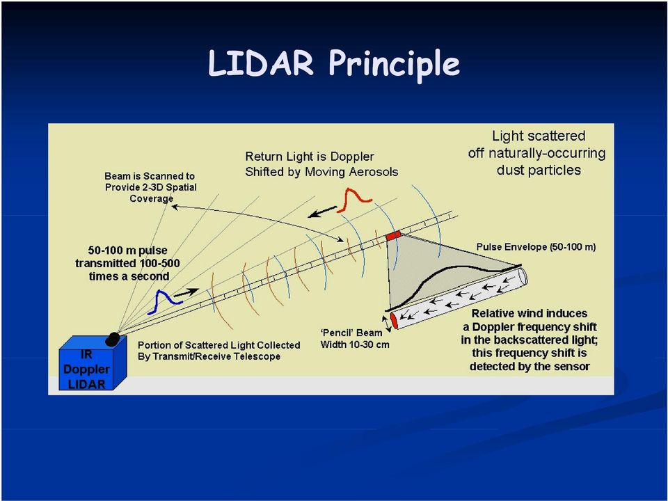
10 LIDAR Principle
11 LIDAR versus TDWR LIDAR works best in fine weather TDWR works best in rainy weather

12 Major Parameters of LIDAR Peak pulse energy 2 mj Wavelength 2 μm Range resolution ~100 m Maximum range ~10 km (weather dependent) Unambiguous velocity range -20 m/s to 20 m/s (extendable to -40 m/s to 40 m/s with reduction in range)

13 Safety Issues Classified as Class 1M under IEC (IEC 2001) and Class 3b under ANSI Z Could be harmful if viewed with optical aids Safety measures Sector blanking Scan rate interlock Laser Safety Officer appointed

14 Schematic diagram of dual LIDAR operation (after relocation) laser beams N glide path

15 Glide-path scan 3 deg for arrival corridors 6 deg for departure corridors

16 Windshear ramp Sustained change of headwind: Ramps prioritized headwind change from one state according to a to another metric Headwind ΔV 3 S = ( ) / 1/3 ΔV H V app H Distance/time
 / 1/3 ΔV H V app H")
17 LIWAS algorithm Measure headwind data along the glide path Generate windshear alerts to WTWS Generate headwind profile Identify windshear ramp

18 What LIWAS sees in 30 August 2004 case

19 Windshear event on 30 March 2005 Windshear reports : RA -15 KT 4NM RA -30 KT 1NM RA 35 KT 1NM RA 25 KT 1NM LA -20 KT 2NM

20 24KT Wind direction, speed and headwind derived from on-board data from aircraft arriving at 0049 UTC. LIWAS headwind profile

21 Winds Blowing Across Terrain (Terrain-induced) induced) d) Easterly to southwesterly winds (e.g. in spring time and in tropical cyclone situation)
22 Winds Blowing Across Terrain (Terrain-induced) induced) d) Northwesterly to northeasterly winds (e.g. in northeast monsoon in winter time)
23 Sea breeze Develops under sunny weather Sea breeze converges with the prevailing wind Sea breeze front Background flow Sea Breeze Usually headwind gain
24 Sea breeze Flying through a sea breeze front could experience headwind loss as well
25 Gust front Leading edge of cool air spreading out from the downdraft of intense storms Headwind gain
26 Characteristics of windshear and turbulence at HKIA Most are terrain-induced induced Transient and sporadic Gain and loss events can co-exist Generally more significant on south runway due to closeness to hills
27 Windshear is transient and sporadic Small-scale disturbances over RWY 25L 30 August 2004
28 Windshear is transient and sporadic Arrows show the movement of the windshear Arrows show the movement of the windshear features in the next 4 minutes
29 Windshear is transient and sporadic path (ft) 6-degree glide Height of Headwind 14:41 UTC Headwind 14:43 UTC 6-degree glide path LIDAR R's radial veloc city (knots) Distance from runway end (NM) 0 Runway corridor 25 LD -1 0 Sequence of headwind changes reversed in 2 minutes!
30 Headwind gain and loss could co-exist Lifting +20Kt Sinking -11Kt 07LA Sinking -17Kt Lifting +12Kt
31 Terrain-induced induced windshear and turbulence points to note Small-sized and evolving rapidly Windshear and turbulence as experienced by an aircraft may at times differ from the conditions reported by the preceding and the ensuing aircraft, and from the alerts provided. Time Aircraft Type Intensity Location 3:50 - None reported - 4:00 A kt loss 3MF 4:02 B kt gain 2MF 4:04 B None reported - 4:10 B kt gain 2MF A day in March 2000 Landings on RWY 07L
32 Gentle windshear ramp 07LA null report of 07LA, null report of windshear at 10:00 UTC, 16 April 2005
33 But sometimes there could be unexpected reports (*) 07LA, report of 20-knot headwind gain at 600 feet at 03:53 UTC, 29 August 2005
34 Gentle windshear ramps at departure corridor
35 TDWR To detect microburst and WS associated with convective storms ~12 km NE of HKIA Radar antenna ~60 m AMSL Runways approx. aligned with TDWR radial TDWR
36 TDWR is purpose-built Radar to detect Hong Kong International Airport microburst and windshear Chek Lap Kok Airport associated with convective storms unobstructed view of airport Raytheon Hardware Supplier Lincoln Lab Algorithms Same model as US FAA s 45 TDWRs operational at US airports easily accessible by transport TDWR 60m above PD; reduce clutters from sea and land
37 km from airport; roughly align with runway direction
38 Beams align well with runway Radial winds roughly measuring headwinds 8º 10º 14º 18º
39 Special features of TDWR Narrow antenna beamwidth 0.5 deg. Good sidelobe performance Excellent target differentiation Highly stable Klystron-based transmitter Able to detect reflectivity below -20 dbz (can detect some returns even in rainless conditions)
40 Special features of TDWR (Cont.) Advanced velocity dealiasing algorithm Employs dual PRFs in the lowest scan to uniquely determine unambiguous velocity data Velocity dealiasing at higher elevations based on assumption of vertical continuity of velocity Unambiguous velocity range -80 m/s to 80 m/s
41 Special features of TDWR (Cont.) Range dealiasing algorithm Low PRF scan at lowest elevation to provide initial view of radar echo returns from the longest range This information is then used to predict the expected degree of obscuration in higher h level l scans s
42 Special features of TDWR (Cont.) Powerful clutter removal mechanism A 55 dbz filter to low velocity data (-2 to 2 m/s) to remove stationary clutter A point-target target removal algorithm to remove moving objects (aircraft, birds and ships) User-defined 30 dbz clutter polygons to remove areas contaminated with moving clutters (traffic, trees)
43 Scanning strategy
44 Change of mode - Specifically, only one of the following within the Hazardous Scan Sector is needed to switch the TDWR from Monitor to Hazardous Weather Mode: a region of 30 dbz (level 2 precipitation) a gust front detection, or a wind-shear or microburst detection. - The TDWR switches from Hazardous Weather to Monitor Mode when the above Hazardous Weather Mode constraints are absent for half an hour.
45 Winds Blowing Across Terrain Another example: (Terrain-induced) induced) d) Severe tropical storm Severe tropical storm Hagupit (11 September 2002)
46 Microburst Most violent form of downdraft from thunderstorms Typical horizontal extent: a few km Headwind increase -> Downdraft -> Tailwind increase Symmetric microburst
47 Some notes on microburst Microburst can be asymmetric. Downdraft column can hit the ground at an angle. Strong terrain-induced induced windshear (loss of 30 knots or greater), coupled with rain, may cause TDWR to issue microburst alerts. Don t expect the typical sequence of events (gain preceding downdraft followed by loss)!
48
49
50 Bandaid shapes microbursts detected by TDWR TDWR microburst algorithm searches for significant divergence radial shear Wind loss (Velocity difference) across divergence region is computed, mptd if loss >= 15 kts AND reflectivity >= 30 dbz -> declare as microburst shape Microburst bandaid shapes showing 20 kts loss 0.6 deg PPI Velocity GSD actually showing 0.6 deg PPI Reflectivity
51 TDWR Alphanumeric Alerts Shear integration of windshear across microburst shape to reduce false alarms (probability only)! Alerts rounded to nearest 5 kts MBA is alerted when loss >= 30 kts WSA is alerted when loss < 30 kts 40 kts loss shown on shape 07L 25R 1NM 2NM 3NM Alerts shown on GSD: 07LD WSA 25K- 2MD 25RA WSA 25K- 2MF D Departure F Final
52
53
54
55
56 Low-level jet Narrow band of strong winds Usually affects aircraft on departure (steeper glide path) Rl Relatively l infrequent at HKIA
57 Microwave radiometer
58 Observations in a windshear event
59 WTWS + Forecaster 80 Percentage of Detection WTWS GLYGA (1 min) GLYGA (5 min) G and R (1 min) G and R (5 min) GorR(1min) G or R (5 min) Radiometer Percentage of Time on Alert
60 Short-range range LIDAR
61
62 + WS reports
63 Observations by the existing LIDAR
64
65 Summary Surface-based anemometers LIDAR TDWR Wind profiler Other new instruments, e.g. microwave radiometer and short-range range LIDAR
66 User education Windshear booklet Windshear posters Briefing Bifi at the airlines ili
67 Major topics of discussion Nature of windshear at Hong Kong International Airport Detection methods Discrepancy between detected and experienced windshear Different practices of windshear reporting by pilots
68 Trend arrow
69 Trend arrow
70 User group meetings Windshear and Turbulence Warning System Working Group (WTWS WG) Low Level Wind Study Working Group (LLWS WG)
71 Participants Met. service Air traffic control Airport standard d Flight standard Airline representative Pilot representative
72 WTWS WG Review of windshear service (objective vs. subjective) New instrument developments Issues of instrument maintenance New procedural developments Windshear phraseology
73 LLWS WG Wind study of effect of buildings/structures on the airflow Windshear warning criteria Deployment of instruments for detecting low level l wind effects
74 Publication HKO homepage: HKO address: IFALPA homepage: GAPAN homepage:
75 Automatic Alerts Issued by WTWS (Windshear and Turbulence Warning System) covering 3 NM from runway thresholds Nominal update rate 1 min.
76 Automatic ti WS Alerts Microburst Alert (MBA) Generated by TDWR (Terminal Doppler Weather Radar) and integrated into WTWS Runway-oriented wind speed loss >= 30 kt and accompanied id by precipitation iitti Windshear Alert (WSA) Runway-oriented wind speed loss or gain >= 15 kt
77 Automatic ti TURB Alerts Moderate or severe in intensity i With reference to heavy category aircraft
78
79
80 Warnings Provided d on ATIS Issued by Aviation i Met. Forecasters Based on pilot reports, forecasting rules developed from case studies, past 30-min TDWR (windshear and microburst), past 30- min WTWS (turbulence), real-time conditions as revealed by TDWR, LIDAR, etc.
81
82
83 Alert Phraseology Very common to have multiple occurrences of windshear on same corridor in HK WTWS consolidates multiple events into ONE integrated alert TDWR alerts higher priority than WTWS alerts Sinking shear (loss events) higher priority than lifting shear (gain events) Max intensity i given in alerts
84 E.g. APP to RWY 25L Alert Phraseology RWY 25L Caution Microburst Minus 30 knots on final approach (instead of specific location as in US) Note: The max intensity (-30 kt) can occur anywhere along the corridor First encounter (+15 3NM) not the worst encounter (-30 1NM)
85 E.g. APP to RWY 25L Alert Phraseology RWY 25L Caution Windshear Minus 15 knots on final approach Note: Some may report -15 kt, while others +20 kt (especially those who conducted a missed APP on encounter of the lf lifting shear)
Reprint 934. LIDAR Windshear Alerting System. at the Hong Kong International Airport. An Application of Information and Communication Technologies
 Reprint 934 LIDAR Windshear Alerting System at the Hong Kong International Airport An Application of Information and Communication Technologies P.W. Chan ICT Conference: The Way to Digital City Sustainable
Low Level Windshear Alert System (LLWAS) An integral part of the U.S. FAA Wind-shear safety program
 An integral part of the U.S. FAA Wind-shear safety program") Low Level Windshear Alert System (LLWAS) An integral part of the U.S. FAA Wind-shear safety program Low-level windshear is a hazard to aircraft in the airport runway corridors. With Climatronics LLWAS,
Low Level Windshear Alert System (LLWAS) An integral part of the U.S. FAA Wind-shear safety program Low-level windshear is a hazard to aircraft in the airport runway corridors. With Climatronics LLWAS,
Weather Radar Basics
 Weather Radar Basics RADAR: Radio Detection And Ranging Developed during World War II as a method to detect the presence of ships and aircraft (the military considered weather targets as noise) Since WW
Wind shear - poses challenges and dangers at the most critical stages of flight
 Wind shear - poses challenges and dangers at the most critical stages of flight Authored and illustrated by Sari Jay June 2009 Introduction Over 40 years ago, in the 1960s, low level wind shear was just
METEOROLOGICAL WARNINGS STUDY GROUP (METWSG)
") METWSG/4-SN No. 9 19/3/12 METEOROLOGICAL WARNINGS STUDY GROUP (METWSG) FOURTH MEETING Montréal, 15 to 18 May 2012 Agenda Item 6: Wind shear, turbulence and tsunami warnings WIND SHEAR INFORMATION (Presented
METWSG/4-SN No. 9 19/3/12 METEOROLOGICAL WARNINGS STUDY GROUP (METWSG) FOURTH MEETING Montréal, 15 to 18 May 2012 Agenda Item 6: Wind shear, turbulence and tsunami warnings WIND SHEAR INFORMATION (Presented
Flight Operations Briefing Notes
 Flight Operations Briefing Notes I Introduction Flight crew awareness and alertness are key factors in the successful application of windshear avoidance and escape / recovery techniques. This Flight Operations
Technical Attachment. The National Weather Service Estimated Actual Velocity Radar Tool. Ken Falk WFO Shreveport, Louisiana
 SRH STSD 2007-03 October 2007 Technical Attachment The National Weather Service Estimated Actual Velocity Radar Tool 1. Introduction Ken Falk WFO Shreveport, Louisiana A radar analysis tool has been introduced
Nowcasting of significant convection by application of cloud tracking algorithm to satellite and radar images
 Nowcasting of significant convection by application of cloud tracking algorithm to satellite and radar images Ng Ka Ho, Hong Kong Observatory, Hong Kong Abstract Automated forecast of significant convection
WEATHER THEORY Temperature, Pressure And Moisture
 WEATHER THEORY Temperature, Pressure And Moisture Air Masses And Fronts Weather Theory- Page 77 Every physical process of weather is a result of a heat exchange. The standard sea level temperature is 59
National Aviation Weather Program Mid-Course Assessment
 National Aviation Weather Program Mid-Course Assessment Accident Reduction Trends Confirm Value of Coordinated R&D Programs Prepared by the Office of the Federal Coordinator for Meteorological Services
WSR - Weather Surveillance Radar
 1 of 7 Radar by Paul Sirvatka College of DuPage Meteorology WSR - Weather Surveillance Radar It was learned during World War II that electromagnetic radiation could be sent out, bounced off an object and
primary SURVEILLANCE 3D RADAR
 AIR TRAFFIC MANAGEMENT AIRport & ROUTE primary SURVEILLANCE 3D RADAR Supplying ATM systems around the world for more than 90 years indracompany.com AIRport & ROUTE primary SURVEILLANCE 3D RADAR Latest
Primus 880 Weather Radar. Reliable Weather Avoidance Radar
 Primus 880 Weather Radar Reliable Weather Avoidance Radar Honeywell, the world s leader in avionics continues the development of weather radar systems with the Primus 880 featuring 10 kilowatts of transmitter
Convective Clouds. Convective clouds 1
 Convective clouds 1 Convective Clouds Introduction Convective clouds are formed in vertical motions that result from the instability of the atmosphere. This instability can be caused by: a. heating at
INITIAL TEST RESULTS OF PATHPROX A RUNWAY INCURSION ALERTING SYSTEM
 INITIAL TEST RESULTS OF PATHPROX A RUNWAY INCURSION ALERTING SYSTEM Rick Cassell, Carl Evers, Ben Sleep and Jeff Esche Rannoch Corporation, 1800 Diagonal Rd. Suite 430, Alexandria, VA 22314 Abstract This
How To Use A Karlsruhe Doppler Lidar
 Andreas Wieser Institut für Meteorologie und Klimaforschung Forschungsbereich Troposphäre (IMK-TRO) First measurements with the new Karlsruhe Doppler Lidar June 03, 2004 Forschungszentrum Karlsruhe we
Wind Field Observations with a Monostatic and Bistatic C-band Doppler Radar Network
 Wind Field Observations with a Monostatic and Bistatic C-band Doppler Radar Network Martin Hagen, DLR Oberpfaffenhofen Wind field and Doppler radar Doppler radar (and lidar) can only measure one component
Flight crew awareness and alertness are key factors in the
 APPROACH-AND-LANDING ACCIDENT REDUCTION TOOL KIT fsf alar briefing note 5.4 Wind Shear Flight crew awareness and alertness are key factors in the successful application of wind shear avoidance techniques
Making Aviation Safer: Results of the National Aviation Weather Program s 10-Year Goal to Reduce Weather- Related Accidents by 80 Percent
 1 Making Aviation Safer: Results of the National Aviation Weather Program s 10-Year Goal to Reduce Weather- Related Accidents by 80 Percent Friends/Partners of Aviation Weather October 9, 2008 Jud Stailey,
3D LANZA FAMILY RADARS
 DEFENSE AND SECURITY 3D LANZA FAMILY RADARS Defense and security in five continents indracompany.com LANZA-MRR/ LANZA-LRR 3D LANZA FAMILY RADARS Radar 3D mobile Long range 3D radar Radar 3D naval State-of-the
CHAPTER 6. Precision Approach Systems
 ELEC4504 Avionics Systems 77 CHAPTER 6. Precision Approach Systems 6.1. Introduction The word approach is used to describe the phase of flight which immediately precedes the landing. While the approach
6.4 THE SIERRA ROTORS PROJECT, OBSERVATIONS OF MOUNTAIN WAVES. William O. J. Brown 1 *, Stephen A. Cohn 1, Vanda Grubiši 2, and Brian Billings 2
 6.4 THE SIERRA ROTORS PROJECT, OBSERVATIONS OF MOUNTAIN WAVES William O. J. Brown 1 *, Stephen A. Cohn 1, Vanda Grubiši 2, and Brian Billings 2 1 National Center for Atmospheric Research, Boulder, Colorado.
InFO Information for Operators
 InFO Information for Operators U.S. Department InFO 07015 of Transportation DATE: 7/3/2007 Federal Aviation Administration Flight Standards Service Washington, DC http://www.faa.gov/other_visit/aviation_industry/airline_operators/airline_safety/info
RDR-4000 IntuVue Weather Radar Pilot Training for Airbus Aircraft
 1 RDR-4000 IntuVue Weather Radar Pilot Training for Airbus Aircraft www.mygdc.com Roger Moore C&PS Flight Technical Services Please dial-in for the audio portion of the webinar International: +1 (703)
1. Specific Differential Phase (KDP)
") 1. Specific Differential Phase (KDP) Instructor Notes: Welcome to the dual polarization radar course. I am Clark Payne with the Warning Decision Training Branch. This lesson is part of the dual-pol products
1. Specific Differential Phase (KDP) Instructor Notes: Welcome to the dual polarization radar course. I am Clark Payne with the Warning Decision Training Branch. This lesson is part of the dual-pol products
Weather Help - NEXRAD Radar Maps. Base Reflectivity
 Weather Help - NEXRAD Radar Maps Base Reflectivity Base Reflectivity Severe Thunderstorm/Torna do Watch Areas 16 levels depicted with colors from dark green (very light) to red (extreme) that indicate
P2.15 A Data Quality Comparison of the WSR-88D Legacy Radar Data Acquisition (RDA) to the Open RDA (ORDA), in a Challenging Clutter Regime
 to the Open RDA (ORDA), in a Challenging Clutter Regime") P2.15 A Data Quality Comparison of the WSR-88D Legacy Radar Data Acquisition (RDA) to the Open RDA (ORDA), in a Challenging Clutter Regime Charles A. Ray* RS Information Systems, Inc. Norman, OK 73072
P2.15 A Data Quality Comparison of the WSR-88D Legacy Radar Data Acquisition (RDA) to the Open RDA (ORDA), in a Challenging Clutter Regime Charles A. Ray* RS Information Systems, Inc. Norman, OK 73072
Air Coverage Test with SCANTER 4002 at Horns Rev Wind Farm I and II
 Air Coverage Test with SCANTER 4002 at Horns Rev Wind Farm I and II Abstract The challenges of aircraft detection in the area of wind farms are addressed. Detection and tracking capabilities of the SCANTER
Flight Operations Briefing Notes
 Flight Operations Briefing Notes I Introduction Although more and more aircraft are equipped with one or two airborne weather radars, incursions into very active cumulonimbus still occur, resulting in
Chapter Overview. Seasons. Earth s Seasons. Distribution of Solar Energy. Solar Energy on Earth. CHAPTER 6 Air-Sea Interaction
 Chapter Overview CHAPTER 6 Air-Sea Interaction The atmosphere and the ocean are one independent system. Earth has seasons because of the tilt on its axis. There are three major wind belts in each hemisphere.
3.5 THREE-DIMENSIONAL HIGH-RESOLUTION NATIONAL RADAR MOSAIC
 3.5 THREE-DIMENSIONAL HIGH-RESOLUTION NATIONAL RADAR MOSAIC Jian Zhang 1, Kenneth Howard 2, Wenwu Xia 1, Carrie Langston 1, Shunxin Wang 1, and Yuxin Qin 1 1 Cooperative Institute for Mesoscale Meteorological
Summary Report on National and Regional Projects set-up in Russian Federation to integrate different Ground-based Observing Systems
 WORLD METEOROLOGICAL ORGANIZATION COMMISSION FOR INSTRUMENT AND METHODS OF OBSERVATION OPAG-UPPER AIR EXPERT TEAM ON REMOTE SENSING UPPER-AIR TECHNOLOGY AND TECHNIQUES First Session Geneva, Switzerland,
Flight information that keeps pilots a step ahead.
 Integrated Flight Information system Flight information that keeps pilots a step ahead. At Rockwell Collins, we re ushering in the era of the truly paperless flight deck while providing a higher level
Paper presented at ISASI 2014 Seminar, October 2014, Adelaide, Australia. Safety Management; Reversing the False Glide Slope Myth
 Safety Management; Reversing the False Glide Slope Myth Kas Beumkes Senior Air Safety Investigator/Project Manager Michiel Schuurman Senior Air Safety Investigator/Technical Investigation Dutch Safety
Accident Bulletin 1/2010. Date and time of accident: 13 April 2010 at 1343 hours local time (0543 UTC)
") Chief Inspector of Accidents Accident Investigation Division Civil Aviation Department 46 th Floor Queensway Government Offices 66 Queensway Hong Kong Accident Bulletin 1/2010 Aircraft type: Airbus A330-342
Chief Inspector of Accidents Accident Investigation Division Civil Aviation Department 46 th Floor Queensway Government Offices 66 Queensway Hong Kong Accident Bulletin 1/2010 Aircraft type: Airbus A330-342
A.4 SEVERE WEATHER PLAN
 Page 1 of 5 A.4 SEVERE WEATHER PLAN 1.0 Purpose 1.1 The purpose of this Severe Weather Response Plan is to minimize the impact on the University from a severe weather incident 2.0 Applicability 2.1 This
Damage Potential of Tropical Cyclone
 Damage Potential of Tropical Cyclone Regional Specialised Meteorological Centre (RSMC)- Tropical Cyclone, New Delhi Cyclone Warning Division India Meteorological Department Mausam Bhavan, Lodi Road, New
Regional Forecast Center Timişoara 15. Gh. Adam St., Timişoara, Romania, e-mail: [email protected]
 Analele UniversităŃii din Oradea Seria Geografie Tom XX, no. 2/2010 (December), pp 197-203 ISSN 1221-1273, E-ISSN 2065-3409 Article no. 202106-492 SOME DOPPLER RADAR FEATURES OF SEVERE WEATHER IN SUPERCELLS
Introduction to the forecasting world Jukka Julkunen FMI, Aviation and military WS
 Boundary layer challenges for aviation forecaster Introduction to the forecasting world Jukka Julkunen FMI, Aviation and military WS 3.12.2012 Forecast for general public We can live with it - BUT Not
Analyze Weather in Cold Regions and Mountainous Terrain
 Analyze Weather in Cold Regions and Mountainous Terrain Terminal Learning Objective Action: Analyze weather of cold regions and mountainous terrain Condition: Given a training mission that involves a specified
Implementation Guidance of Aeronautical Meteorological Forecaster Competency Standards
 Implementation Guidance of Aeronautical Meteorological Forecaster Competency Standards The following guidance is supplementary to the AMP competency Standards endorsed by Cg-16 in Geneva in May 2011. Implicit
Overview of Sensors and Detection Systems for Wildlife Hazard Management
 Overview of Sensors and Detection Systems for Wildlife Hazard Management Edwin E. Herricks Professor Emeritus University of Illinois Center of Excellence for Airport Technology Airport Safety Management
Head 168 HONG KONG OBSERVATORY
 Controlling officer: the Director of the Hong Kong Observatory will account for expenditure under this Head. Estimate... $203.4m Establishment ceiling (notional annual mid-point salary value) representing
Name Period 4 th Six Weeks Notes 2015 Weather
 Name Period 4 th Six Weeks Notes 2015 Weather Radiation Convection Currents Winds Jet Streams Energy from the Sun reaches Earth as electromagnetic waves This energy fuels all life on Earth including the
Addendum for compatible Navico MFD s that support the following Broadband 4G Radar features:
 Addendum for compatible Navico MFD s that support the following Broadband 4G Radar features: Dual Radar Dual Range 4G Radar Controls -Target - Separation -Noise - Rejection -Fast - Scan Directional Clutter
Airborne-Weather-Radar Interpretation Ian Gilbert
 Ian Gilbert This familiarisation is targeted for aircraft equipped with Honeywell weather radar. The fundamental principles are, however, applicable to all weather radars in all aircraft. Weather-Radar
Wildlife Hazard Mitigation Strategies for Pilots
 Executive Summary From the very beginning of powered flight, pilots have competed with birds for airspace, sometimes with disastrous results. Over the years, there have been many efforts to create a better
8-1 Chapter 8 Radio Operations: Aviation Spoken Here
 8-1 Chapter 8 Radio Operations: Aviation Spoken Here Radio Technique 1. [8-2/1/1] Using the radio is no great mystery. When transmitting, hold the radio close to your. A. mouth B. ear C. tongue VHF Transmitions
Flight Operations Briefing Notes
 Flight Operations Briefing Notes I Introduction Encountering wake turbulence in flight can be a surprising experience, both for crews and passengers. Wake turbulence occurs suddenly, and is usually accompanied
OPERATING MINIMA FOR AEROPLANES AND HELICOPTER OPERATIONS PURPOSE REFERENCE 4.0 DEFINITION
 ORDER TCAA-O-OPS034A March 2013 OPERATING MINIMA FOR AEROPLANES AND HELICOPTER OPERATIONS PURPOSE 1. This Order gives guidance to the Authority s Operations Inspector on the procedures for approval of
Flight Operations Briefing Notes
 Flight Operations Briefing Note I Introduction Operations in crosswind conditions require strict adherence to applicable crosswind limitations or maximum recommended crosswind values, operational recommendations
Roelof Bruintjes, Sarah Tessendorf, Jim Wilson, Rita Roberts, Courtney Weeks and Duncan Axisa WMA Annual meeting 26 April 2012
 Aerosol affects on the microphysics of precipitation development in tropical and sub-tropical convective clouds using dual-polarization radar and airborne measurements. Roelof Bruintjes, Sarah Tessendorf,
Vindicator Security Solutions EXTEND YOUR SECURITY PERIMETER. Vindicator Radar Detection System
 Vindicator Security Solutions EXTEND YOUR SECURITY PERIMETER Vindicator Radar Detection System Extend Your Security Perimeter Many security solutions today are required to provide advanced detection of
How to analyze synoptic-scale weather patterns Table of Contents
 How to analyze synoptic-scale weather patterns Table of Contents Before You Begin... 2 1. Identify H and L pressure systems... 3 2. Locate fronts and determine frontal activity... 5 3. Determine surface
Full Waveform Digitizing, Dual Channel Airborne LiDAR Scanning System for Ultra Wide Area Mapping
 Full Waveform Digitizing, Dual Channel Airborne LiDAR Scanning System for Ultra Wide Area Mapping RIEGL LMS-Q56 high laser pulse repetition rate up to 8 khz digitization electronics for full waveform data
Radar Systems Engineering Lecture 6 Detection of Signals in Noise
 Radar Systems Engineering Lecture 6 Detection of Signals in Noise Dr. Robert M. O Donnell Guest Lecturer Radar Systems Course 1 Detection 1/1/010 Block Diagram of Radar System Target Radar Cross Section
Ms. Jarrette reported that operations at OEA, with inquiries/complaints. These approaches to runways 07 and
 On Thursday, July 9, 2015 the Aviation Noise Abatement Committee (ANAC) of the Greater Orlando Aviation Authority met in regular session at University of Florida IFAS Extension, South Conway Road, Orlando,
WEATHER AND CLIMATE practice test
 WEATHER AND CLIMATE practice test Multiple Choice Identify the choice that best completes the statement or answers the question. 1. What role does runoff play in the water cycle? a. It is the process in
Familiarisation Briefing for Jet and Multiengine Aircraft Crews.
 Familiarisation Briefing for Jet and Multiengine Aircraft Crews. 1 Index Version/lang. 1.8 Status: final Date of issue: 2010 20. December Author/unit: Tower, MT,BH,CM Owner/unit: Engadin Airport AG File:
3. FLYING TECHNIQUES. 3.1 Speed Management. 3.2 Attitude Management. 3.3 Height Management. 3.4 Transit Flying
 3. FLYING TECHNIQUES 3.1 Speed Management Maintaining an appropriate airspeed can be very challenging in mountainous terrain. Pilots need to be aware of the speed limitations from the RFM especially in
IBM Big Green Innovations Environmental R&D and Services
 IBM Big Green Innovations Environmental R&D and Services Smart Weather Modelling Local Area Precision Forecasting for Weather-Sensitive Business Operations (e.g. Smart Grids) Lloyd A. Treinish Project
siemens.com/mobility Radar detectors of the Heimdall family High detection rate, easy installation
 siemens.com/mobility Radar detectors of the Heimdall family High detection rate, easy installation Heimdall radar detectors from Siemens: A family that provides valuable benefits, Heimdall is the watchman
Hong Kong Observatory Summer Placement Programme 2015
 Annex I Hong Kong Observatory Summer Placement Programme 2015 Training Programme : An Observatory mentor with relevant expertise will supervise the students. Training Period : 8 weeks, starting from 8
Evalua&ng Downdra/ Parameteriza&ons with High Resolu&on CRM Data
 Evalua&ng Downdra/ Parameteriza&ons with High Resolu&on CRM Data Kate Thayer-Calder and Dave Randall Colorado State University October 24, 2012 NOAA's 37th Climate Diagnostics and Prediction Workshop Convective
4.12 Improving wind profiler data recovery in non-uniform precipitation using a modified consensus algorithm
 4.12 Improving wind profiler data recovery in non-uniform precipitation using a modified consensus algorithm Raisa Lehtinen 1, Daniel Gottas 2, Jim Jordan 3, Allen White 2 1 Vaisala Inc, Boulder, Colorado,
Aircraft incident to SE-KPE during approach to the Malmö/Sturup airport, M county, Sweden, on 03 December 1999
 Aircraft incident to SE-KPE during approach to the Malmö/Sturup airport, M county, Sweden, on 03 December 1999 Micro-summary: On approach, this Saab 340 was hit by lightning, causing dual generator electrical
3D LANZA RADAR FAMILY
 3D LANZA RADAR FAMILY Surveillance in five continents indracompany.com LANZA-LRR/ LANZA-MRR/ LANZA-LTR 3D LANZA RADAR FAMILY Transportable 3D Radar Mobile 3D Radar (Trailer) Mobile 3D Radar (Truck Mounter)
12 AERO Second-Quarter 2003 April CAPT. RAY CRAIG 737 CHIEF PILOT FLIGHT OPERATIONS BOEING COMMERCIAL AIRPLANES
 CAPT. RAY CRAIG 737 CHIEF PILOT FLIGHT OPERATIONS BOEING COMMERCIAL AIRPLANES DREW HOUCK ASSOCIATE TECHNICAL FELLOW FLIGHT DECK DISPLAYS BOEING COMMERCIAL AIRPLANES ROLAN SHOMBER ASSOCIATE TECHNICAL FELLOW
Automation at Odds. A 737 stalled when a radio altimeter malfunction caused the autothrottle and autopilot to diverge during an approach to Schiphol.
 Automation at Odds The pilots of a Boeing 737-800 did not heed indications of a significant decrease in airspeed until the stick shaker activated on final approach to Runway 18R at Amsterdam (Netherlands)
The Mayor of London s Submission:
 Inner Thames Estuary Feasibility Study Response to Airports Commission Call for Evidence The Mayor of London s Submission: Supporting technical documents 23 May 2014 Title: Runway utilisation Author: Atkins
ICAO Safety Management Systems (SMS) Course Handout N 5 Cuzco International Airport operation
 Course Handout N 5 Cuzco International Airport operation") ICAO Safety Management Systems (SMS) Course Handout N 5 Cuzco International Airport operation International Civil Aviation Organization Page left blank intentionally ICAO Safety management systems (SMS)
ICAO Safety Management Systems (SMS) Course Handout N 5 Cuzco International Airport operation International Civil Aviation Organization Page left blank intentionally ICAO Safety management systems (SMS)
FACTUAL REPORT AVIATION
 Aircraft Registration Number: N8098T Occurrence Date: Occurrence Type: 03/07/005 Accident Most Critical Injury: Minor Investigated By: NTSB Location/Time Nearest City/Place Shreveport Zip Code Local Time
How To Set Up A Wide Area Surveillance System
 Introduction The purpose of this white paper is to examine the benefits and limitations of shore based marine radar for waterside security applications. This technology has been deployed for over 60 years
FACTUAL REPORT AVIATION
 Location/Time Aircraft Registration Number: Most Critical Injury: Minor Investigated By: NTSB N911BL Nearest /Place Zip Code Local Time Time Zone Las Vegas NV 89032 1600 PDT Airport Proximity: On Airport/Airstrip
Aircraft Radio Operator Certificate of Proficiency
 Aircraft Radio Operator Certificate of Proficiency 327 Flight AAFC Designed by PLTOFF(AAFC) Stewart Hignett Amended for 327FLT by SQNLDR(AAFC) Bill Gleeson-Barker, OCT10 Objectives Understand legislation
RAPIDS Operational Blending of Nowcasting and NWP QPF
 RAPIDS Operational Blending of Nowcasting and NWP QPF Wai-kin Wong and Edwin ST Lai Hong Kong Observatory The Second International Symposium on Quantitative Precipitation Forecasting and Hydrology 5-8
Adjustment of Anemometer Readings for Energy Production Estimates WINDPOWER June 2008 Houston, Texas
 Adjustment of Anemometer Readings for Energy Production Estimates WINDPOWER June 2008 Houston, Texas Matthew Filippelli, Julien Bouget, Michael Brower, and Dan Bernadett AWS Truewind, LLC 463 New Karner
Storms Short Study Guide
 Name: Class: Date: Storms Short Study Guide Multiple Choice Identify the letter of the choice that best completes the statement or answers the question. 1. A(n) thunderstorm forms because of unequal heating
FORENSIC WEATHER CONSULTANTS, LLC
 SAMPLE, CONDENSED REPORT DATES AND LOCATIONS HAVE BEEN CHANGED FORENSIC WEATHER CONSULTANTS, LLC Howard Altschule Certified Consulting Meteorologist 1971 Western Avenue, #200 Albany, New York 12203 518-862-1800
ABSTRACT INTRODUCTION
 Observing Fog And Low Cloud With A Combination Of 78GHz Cloud Radar And Laser Met Office: Darren Lyth 1, John Nash. Rutherford Appleton Laboratory: M.Oldfield ABSTRACT Results from two demonstration tests
In a majority of ice-crystal icing engine events, convective weather occurs in a very warm, moist, tropical-like environment. aero quarterly qtr_01 10
 In a majority of ice-crystal icing engine events, convective weather occurs in a very warm, moist, tropical-like environment. 22 avoiding convective Weather linked to Ice-crystal Icing engine events understanding
Data Review and Analysis Program (DRAP) Flight Data Visualization Program for Enhancement of FOQA
 Flight Data Visualization Program for Enhancement of FOQA") 86 Data Review and Analysis Program (DRAP) Flight Data Visualization Program for Enhancement of FOQA Koji MURAOKA and Noriaki OKADA, Flight Systems Research Center, E-mail: [email protected] Keywords:
86 Data Review and Analysis Program (DRAP) Flight Data Visualization Program for Enhancement of FOQA Koji MURAOKA and Noriaki OKADA, Flight Systems Research Center, E-mail: [email protected] Keywords:
What Causes Climate? Use Target Reading Skills
 Climate and Climate Change Name Date Class Climate and Climate Change Guided Reading and Study What Causes Climate? This section describes factors that determine climate, or the average weather conditions
ITEM FOR FINANCE COMMITTEE
 For discussion on 12 June 2009 FCR(2009-10)24 ITEM FOR FINANCE COMMITTEE HEAD 166 - GOVERNMENT FLYING SERVICE Subhead 603 Plant, vehicles and equipment New Item Replacement of two fixed-wing aircraft and
ILS Replacement. ACI World Safety Seminar. 18 19 November 2008 Kempinski Hotel Beijing Lufthansa Centre
 ILS Replacement Xiaosong Xiao, PhD Tetra Tech, Inc. Orlando, USA Contents: Ground-Based Navigation ILS Approach GNSS/SBAS Approach Comparisons between ILS and GNSS Example: Cost Analysis Between LAAS and
MANUAL ON SIMULTANEOUS OPERATIONS ON PARALLEL OR NEAR-PARALLEL INSTRUMENT RUNWAYS (SOIR)
") Appendix APPENDIX DRAFT MANUAL ON SIMULTANEOUS OPERATIONS ON PARALLEL OR NEAR-PARALLEL INSTRUMENT RUNWAYS (SOIR) FIRST EDITION - 2004 Appendix A-2 FOREWORD In 1980 the Air Navigation Commission reviewed
Appendix APPENDIX DRAFT MANUAL ON SIMULTANEOUS OPERATIONS ON PARALLEL OR NEAR-PARALLEL INSTRUMENT RUNWAYS (SOIR) FIRST EDITION - 2004 Appendix A-2 FOREWORD In 1980 the Air Navigation Commission reviewed
Implementation of a Gabor Transform Data Quality-Control Algorithm for UHF Wind Profiling Radars
 VOLUME 30 J O U R N A L O F A T M O S P H E R I C A N D O C E A N I C T E C H N O L O G Y DECEMBER 2013 Implementation of a Gabor Transform Data Quality-Control Algorithm for UHF Wind Profiling Radars
Active and Passive Microwave Remote Sensing
 Active and Passive Microwave Remote Sensing Passive remote sensing system record EMR that was reflected (e.g., blue, green, red, and near IR) or emitted (e.g., thermal IR) from the surface of the Earth.
ATMS 310 Jet Streams
 ATMS 310 Jet Streams Jet Streams A jet stream is an intense (30+ m/s in upper troposphere, 15+ m/s lower troposphere), narrow (width at least ½ order magnitude less than the length) horizontal current
Navi-Radar 4000 and Navi-Sailor 4000 ECS for workboats and small crafts BIG SOLUTIONS FOR SMALL VESSELS
 Navi-Radar 4000 and Navi-Sailor 4000 ECS for workboats and small crafts BIG SOLUTIONS FOR SMALL VESSELS TRANSAS WORKBOAT SERIES Transas Workboat series offers the same technology, performance and quality