RAPIDS Operational Blending of Nowcasting and NWP QPF
|
|
|
- Jared Casey
- 8 years ago
- Views:
Transcription
1 RAPIDS Operational Blending of Nowcasting and NWP QPF Wai-kin Wong and Edwin ST Lai Hong Kong Observatory The Second International Symposium on Quantitative Precipitation Forecasting and Hydrology 5-8 June

2 Lin et al (2004) 2
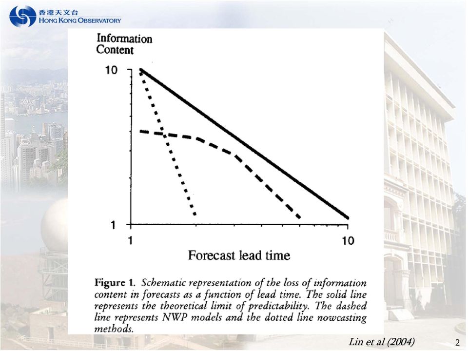
3 extrapolation effective in advective cases more effective in nonlinear moving; rapidly changing cases Nowcast High resolution NWP high resolution, rapidly updated seamless very-short-range QPF 3

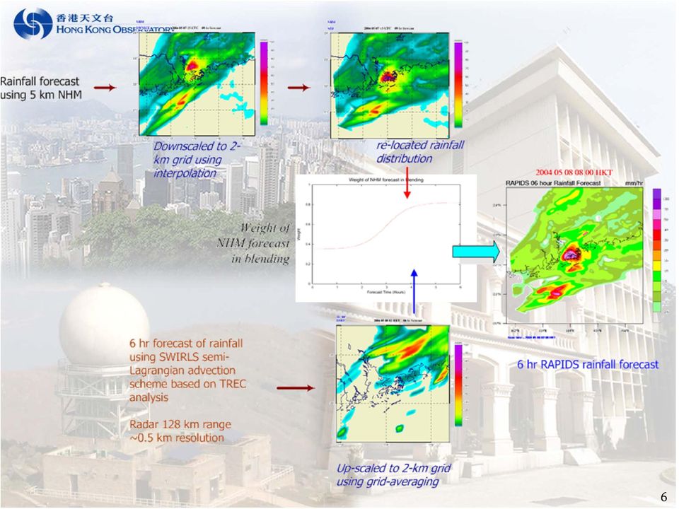
4 RAPIDS Rainstorm Analysis and Prediction Integrated Data-processing System Nowcasting component SWIRLS 1-6 hr QPF by extending the linear extrapolation of radar echoes NWPcomponent Non-hydrostatic Model (NHM) 1 6 hr QPF by non-hydrostatic numerical model Hourly update 2 km resolution T+1 T + 6 hour forecast 4

5 5

6 6
7 Extending SWIRLS F/C to 6 hr modified semi-lagrangian advection scheme (SLAS) Robert scheme (3 iterations) Bi-cubic Lagrangian interpolation Flux limiter (local max, min constraint) One-way nesting resolution 1.1 km -> 0.5 km Less dispersive Circulation preserved dz dt = Z t Z + u x = 0 TREC wind Forecast reflectivity TREC wind Up to 6 hr (6-min interval) Forecast reflectivity pure rotation Up to 6 hr (6-min interval) 7

8 Performance Verification data sets : 8 May 20 Dec 2005 Overall, similar performance For Amber, SLA slightly better than LE POD (SLA) POD (LE) 0.8 FAR (SLA) FAR (LE) Performance CSI (SLA) PIL (SLA) CSI (LE) PIL (LE) Amber Rain Red Rain Flood Landslip Warning Guidance Issued By SWIRLS 8
 PIL (SLA) CSI (LE) PIL (LE) 0.3 0.2 0.1 0.")
9 Non-hydrostatic Model (NHM) 5-km horizontal resolution 121x121 grid-points, 45 vertical levels (lowest at 10m ) Trial operation started in April 04 (two runs per day) and upgraded to hourly update in April 05 Initial : RSM + LAPS moisture Boundary : RSM KF + 3 ice bulk cloud microphysics 9

10 Remote sensing data assimilated in HKO-LAPS Radar reflectivity and Doppler velocity Geostationary satellite imagery GPS PWV Radar derived echo movement (TREC wind) QuikSCAT retrieved wind 10
 QuikSCAT")
11 LAPS + NHM Initialized by ORSM 15 UTC 7 May 2004 T + 8 hr forecast Initialized by LAPS (no radar data) 11
 11")
12 Initialized by LAPS with radar and GPS data 12

13 Blending SWIRLS and NHM QPF QPF ( t) = (1 w( t)) QPF + w( t) SLAS QPF NHM 1. NHM rain pattern adjustment translation, rotation, deformation 2. Dynamical blending hyperbolic function with varying end points adjustment β α β α w( T ) = α + T 2 { 1+ tanh[ γ (3 9)] } α, β determined dynamically by past performance 13
 = α + T 2 { 1+ tanh[ γ (3 9)] } α, β determined dynamically by past")
14 Location adjustment Rigid and projective transforms J ( M ) = = = e 2 x, y [ I ( x', y') I( x, y) ] f [ I ( x', y') I( x, y) ] f 2 2 dxdy nonlinear coordinates transformation where x' y' = x M y I f ( x, y) I ( x, y) Input image reference image transformed image I f ( x', y') I f ( x, y) Szeliski (1996) 14
 I f ( x, y) Szeliski")
15 α and β derived from real-time verification of QPFs from NHM and SWIRLS β α γ 1 β α w( T ) = α + T 2 { 1 + tanh[ γ ( 3)] } 15
] }")
16 ν SWIRLS w( t) = ( t = 0; t = ν + ν SWIRLS NHM 6) ν = max( h( R1, R2 ), h( R2, R1 )) 2μR μ 2 1 R σ 2 R σ 1 R μ + μ σ + σ R 1 R 2 R 1 R 2 Measure of spatial error Intensity difference mean value of R 1 NHM QPF Radar rainfall analysis standard deviation of R 1 ν = 0 (perfect match) ν -> (totally mismatch) Venugopal et.al. (2005) 16
 ν -> (totally mismatch) Venugopal et.")
17 Re-visit of blending weight Frequency distribution of α and β Lost of pattern matching skill in SWIRLS SLA T+6 hr forecast 17

18 Re-visit of relocation vector NHM Forecast Rainfall Analysis min [ R NHM ( x, y) R an ( x u, y v)] 2 da 18
 R an ( x u, y")
19 T + 1 hr T + 3 hr x - component y - component 19

20 T + 6 hr T + 9 hr x - component y - component 20

21 SWIRLS SLAS F/C NHM DMO F/C NHM F/C (rigid transformed) + Radar observation (verification) RAPIDS F/C SWIRLS good intensity F/C NHM good storm development F/C RAPIDS the best F/C 21
22 Red rainstorm 2 June
23 Red rainstorm on 2 June
24 T+5 and T+6 hr f/c starting at 06HKT SWIRLS SLA NHM DMO ACTUAL 24
25 NHM with phase correction RAPIDS ACTUAL 25
26 T+3 hr and T+4hr f/c starting from 08HKT SWIRLS SLA NHM DMO ACTUAL 26
27 NHM with phase correction RAPIDS ACTUAL 27
28 22 HKT 29 July 2005 (outer rain-bands due to TS Washi) Relocation of rainband based on projective transform Actual rainfall analysis at 22 HKT Relocation of rainband based on rigid transform 28
29 6-hr forecast from NHM 6-hr forecast from NHM Rigid transform 3-hr forecast from SWIRLS SLAS Projective transform 29
30 RAPIDS : Performance in 2005 More skillful rainfall forecast using blending Similar performance for two pattern adjustment schemes Grid-based (2km resolution) rain/no-rain verification Rainstorm cases in 2005 ~ 170 # of forecast 30
31 Concluding remarks RAPIDS combines QPF from SWIRLS: frequently update radar obs + improved advection forecast NHM: information on development of precipitation Optimal blending to add further skills in QPF using nowcast and NWP Future development Intensity change in SWIRLS QPF Improve the data assimilation system for NHM Regional phase correction guidance on potential precipitation development from other model forecast elements Probabilistic QPF 31
32 The End Thank you 32
Nowcasting of significant convection by application of cloud tracking algorithm to satellite and radar images
 Nowcasting of significant convection by application of cloud tracking algorithm to satellite and radar images Ng Ka Ho, Hong Kong Observatory, Hong Kong Abstract Automated forecast of significant convection
Proposals of Summer Placement Programme 2015
 Proposals of Summer Placement Programme 2015 Division Project Title Job description Subject and year of study required A2 Impact of dual-polarization Doppler radar data on Mathematics or short-term related
Nowcasting: analysis and up to 6 hours forecast
 Nowcasting: analysis and up to 6 hours forecast Very high resoultion in time and space Better than NWP Rapid update Application oriented NWP problems for 0 6 forecast: Incomplete physics Resolution space
ICAO Developments (Hazardous Weather Information)
") ICAO Developments (Hazardous Weather Information) USER NEEDS AND EXPECTATION IATA s viewpoint Harmonized information about hazardous meteorological conditions that may constrain operations along intended
ICAO Developments (Hazardous Weather Information) USER NEEDS AND EXPECTATION IATA s viewpoint Harmonized information about hazardous meteorological conditions that may constrain operations along intended
NOWCASTING OF PRECIPITATION Isztar Zawadzki* McGill University, Montreal, Canada
 NOWCASTING OF PRECIPITATION Isztar Zawadzki* McGill University, Montreal, Canada 1. INTRODUCTION Short-term methods of precipitation nowcasting range from the simple use of regional numerical forecasts
Hong Kong Observatory Summer Placement Programme 2015
 Annex I Hong Kong Observatory Summer Placement Programme 2015 Training Programme : An Observatory mentor with relevant expertise will supervise the students. Training Period : 8 weeks, starting from 8
Big Data Assimilation Revolutionizing Weather Prediction
 February 23, 2015, ISDA2015, Kobe Big Data Assimilation Revolutionizing Weather Prediction M. Kunii, J. Ruiz, G.-Y. Lien, K. Kondo, S. Otsuka, Y. Maejima, and Takemasa Miyoshi* RIKEN Advanced Institute
National Weather Service Flash Flood Modeling and Warning Services
 National Weather Service Flash Flood Modeling and Warning Services Seann Reed, Middle Atlantic River Forecast Center Peter Ahnert, Middle Atlantic River Forecast Center August 23, 2012 USACE Flood Risk
Developing Continuous SCM/CRM Forcing Using NWP Products Constrained by ARM Observations
 Developing Continuous SCM/CRM Forcing Using NWP Products Constrained by ARM Observations S. C. Xie, R. T. Cederwall, and J. J. Yio Lawrence Livermore National Laboratory Livermore, California M. H. Zhang
FLOODALERT: A SIMPLIFIED RADAR-BASED EWS FOR URBAN FLOOD WARNING
 11 th International Conference on Hydroinformatics HIC 2014, New York City, USA FLOODALERT: A SIMPLIFIED RADAR-BASED EWS FOR URBAN FLOOD WARNING XAVIER LLORT (1), RAFAEL SÁNCHEZ-DIEZMA (1), ÁLVARO RODRÍGUEZ
Real-time Ocean Forecasting Needs at NCEP National Weather Service
 Real-time Ocean Forecasting Needs at NCEP National Weather Service D.B. Rao NCEP Environmental Modeling Center December, 2005 HYCOM Annual Meeting, Miami, FL COMMERCE ENVIRONMENT STATE/LOCAL PLANNING HEALTH
Triple eyewall experiment of the 2012 typhoon Bolaven using cloud resolving ensemble forecast
 The 3 rd Research meeting of Ultrahigh Precision Meso Scale Weather Prediction Thu. 21 Mar. 2013 Triple eyewall experiment of the 2012 typhoon Bolaven using cloud resolving ensemble forecast Seiji ORIGUCHI,
Cloud Model Verification at the Air Force Weather Agency
 2d Weather Group Cloud Model Verification at the Air Force Weather Agency Matthew Sittel UCAR Visiting Scientist Air Force Weather Agency Offutt AFB, NE Template: 28 Feb 06 Overview Cloud Models Ground
Precipitation nowcasting at Finnish Meteorological Institute
 Precipitation nowcasting at Finnish Meteorological Institute Jarmo Koistinen (1), Erik Gregow (1), Harri Hohti (1), Janne Kauhanen (1), Juha Kilpinen (1), Pekka Rossi (1), Mari Heinonen (2), Daniel Sempere-Torres
IBM Big Green Innovations Environmental R&D and Services
 IBM Big Green Innovations Environmental R&D and Services Smart Weather Modelling Local Area Precision Forecasting for Weather-Sensitive Business Operations (e.g. Smart Grids) Lloyd A. Treinish Project
Weather Radar Basics
 Weather Radar Basics RADAR: Radio Detection And Ranging Developed during World War II as a method to detect the presence of ships and aircraft (the military considered weather targets as noise) Since WW
Real-time Global Flood Monitoring and Forecasting using an Enhanced Land Surface Model with Satellite and NWP model based Precipitation
 Real-time Global Flood Monitoring and Forecasting using an Enhanced Land Surface Model with Satellite and NWP model based Precipitation Huan Wu,2, Robert F. Adler, 2, Yudong Tian, 2, George J. Huffman
Flood and risk forecasting using innovative tools. X. Llort, R. Sánchez-Diezma
 Flood and risk forecasting using innovative tools X. Llort, R. Sánchez-Diezma EWS Data Weather Radar Data NWP Data Raingauges Sensors Aditional Data Autoprotection Plans. Protocols. Impact: costs, etc.
[ Climate Data Collection and Forecasting Element ] An Advanced Monitoring Network In Support of the FloodER Program
![[ Climate Data Collection and Forecasting Element ] An Advanced Monitoring Network In Support of the FloodER Program](/thumbs/33/16326315.jpg "[ Climate Data Collection and Forecasting Element ] An Advanced Monitoring Network In Support of the FloodER Program") [ Climate Data Collection and Forecasting Element ] An Advanced Monitoring Network In Support of the FloodER Program December 2010 1 Introduction Extreme precipitation and the resulting flooding events
[ Climate Data Collection and Forecasting Element ] An Advanced Monitoring Network In Support of the FloodER Program December 2010 1 Introduction Extreme precipitation and the resulting flooding events
ANALYSIS OF THUNDERSTORM CLIMATOLOGY AND CONVECTIVE SYSTEMS, PERIODS WITH LARGE PRECIPITATION IN HUNGARY. Theses of the PhD dissertation
 ANALYSIS OF THUNDERSTORM CLIMATOLOGY AND CONVECTIVE SYSTEMS, PERIODS WITH LARGE PRECIPITATION IN HUNGARY Theses of the PhD dissertation ANDRÁS TAMÁS SERES EÖTVÖS LORÁND UNIVERSITY FACULTY OF SCIENCE PhD
Development of an Integrated Data Product for Hawaii Climate
 Development of an Integrated Data Product for Hawaii Climate Jan Hafner, Shang-Ping Xie (PI)(IPRC/SOEST U. of Hawaii) Yi-Leng Chen (Co-I) (Meteorology Dept. Univ. of Hawaii) contribution Georgette Holmes
Fog and low cloud ceilings in the northeastern US: climatology and dedicated field study
 Fog and low cloud ceilings in the northeastern US: climatology and dedicated field study Robert Tardif National Center for Atmospheric Research Research Applications Laboratory 1 Overview of project Objectives:
Comparative Evaluation of High Resolution Numerical Weather Prediction Models COSMO-WRF
 3 Working Group on Verification and Case Studies 56 Comparative Evaluation of High Resolution Numerical Weather Prediction Models COSMO-WRF Bogdan Alexandru MACO, Mihaela BOGDAN, Amalia IRIZA, Cosmin Dănuţ
Investigations on COSMO 2.8Km precipitation forecast
 Investigations on COSMO 2.8Km precipitation forecast Federico Grazzini, ARPA-SIMC Emilia-Romagna Coordinator of physical aspects group of COSMO Outline Brief description of the COSMO-HR operational suites
Application of Numerical Weather Prediction Models for Drought Monitoring. Gregor Gregorič Jožef Roškar Environmental Agency of Slovenia
 Application of Numerical Weather Prediction Models for Drought Monitoring Gregor Gregorič Jožef Roškar Environmental Agency of Slovenia Contents 1. Introduction 2. Numerical Weather Prediction Models -
HAZARD RISK ASSESSMENT, MONITORING, MAINTENANCE AND MANAGEMENT SYSTEM (HAMMS) FOR LANDSLIDE AND FLOOD. Mohd. Nor Desa, Rohayu and Lariyah, UNITEN
 FOR LANDSLIDE AND FLOOD. Mohd. Nor Desa, Rohayu and Lariyah, UNITEN") HAZARD RISK ASSESSMENT, MONITORING, MAINTENANCE AND MANAGEMENT SYSTEM (HAMMS) FOR LANDSLIDE AND FLOOD Mohd. Nor Desa, Rohayu and Lariyah, UNITEN WHAT WE HAVE IN MIND AND FROM OUR PREVIOUS PROJECT CONTRIBUTION
HAZARD RISK ASSESSMENT, MONITORING, MAINTENANCE AND MANAGEMENT SYSTEM (HAMMS) FOR LANDSLIDE AND FLOOD Mohd. Nor Desa, Rohayu and Lariyah, UNITEN WHAT WE HAVE IN MIND AND FROM OUR PREVIOUS PROJECT CONTRIBUTION
Meteorological Forecasting of DNI, clouds and aerosols
 Meteorological Forecasting of DNI, clouds and aerosols DNICast 1st End-User Workshop, Madrid, 2014-05-07 Heiner Körnich (SMHI), Jan Remund (Meteotest), Marion Schroedter-Homscheidt (DLR) Overview What
Sub-grid cloud parametrization issues in Met Office Unified Model
 Sub-grid cloud parametrization issues in Met Office Unified Model Cyril Morcrette Workshop on Parametrization of clouds and precipitation across model resolutions, ECMWF, Reading, November 2012 Table of
Overview of the IR channels and their applications
 Ján Kaňák Slovak Hydrometeorological Institute Jan.kanak@shmu.sk Overview of the IR channels and their applications EUMeTrain, 14 June 2011 Ján Kaňák, SHMÚ 1 Basics in satellite Infrared image interpretation
MOGREPS status and activities
 MOGREPS status and activities by Warren Tennant with contributions from Rob Neal, Sarah Beare, Neill Bowler & Richard Swinbank Crown copyright Met Office 32 nd EWGLAM and 17 th SRNWP meetings 1 Contents
"Attività di modellistica numerica previsionale meteorologica al Servizio IdroMeteoClima di ARPA Emilia-Romagna"
 "Attività di modellistica numerica previsionale meteorologica al Servizio IdroMeteoClima di ARPA Emilia-Romagna" Author: Tiziana Paccagnella Organization: ARPA SIMC 1 ARPA-SIMC Modelling Group Head of
Outline. Case Study over Vale do Paraiba 11 February 2012. Comparison of different rain rate retrievals for heavy. Future Work
 Outline Short description of the algorithms for rain rate retrievals from passive microwave radiometers on board low-orbiting satellites (i.e., SSMI/S) Case Study over Vale do Paraiba 11 February 2012
Partnership to Improve Solar Power Forecasting
 Partnership to Improve Solar Power Forecasting Venue: EUPVSEC, Paris France Presenter: Dr. Manajit Sengupta Date: October 1 st 2013 NREL is a national laboratory of the U.S. Department of Energy, Office
The horizontal diffusion issue in CRM simulations of moist convection
 The horizontal diffusion issue in CRM simulations of moist convection Wolfgang Langhans Institute for Atmospheric and Climate Science, ETH Zurich June 9, 2009 Wolfgang Langhans Group retreat/bergell June
Very High Resolution Arctic System Reanalysis for 2000-2011
 Very High Resolution Arctic System Reanalysis for 2000-2011 David H. Bromwich, Lesheng Bai,, Keith Hines, and Sheng-Hung Wang Polar Meteorology Group, Byrd Polar Research Center The Ohio State University
Mode-S Enhanced Surveillance derived observations from multiple Air Traffic Control Radars and the impact in hourly HIRLAM
 Mode-S Enhanced Surveillance derived observations from multiple Air Traffic Control Radars and the impact in hourly HIRLAM 1 Introduction Upper air wind is one of the most important parameters to obtain
SAFNWC/MSG Cloud type/height. Application for fog/low cloud situations
 SAFNWC/MSG Cloud type/height. Application for fog/low cloud situations 22 September 2011 Hervé LE GLEAU, Marcel DERRIEN Centre de météorologie Spatiale. Lannion Météo-France 1 Fog or low level clouds?
Center for Analysis and Prediction of Storms, and School of Meteorology, University of Oklahoma, Norman, Oklahoma KEITH BREWSTER
 FEBRUARY 2006 H U E T A L. 675 3DVAR and Cloud Analysis with WSR-88D Level-II Data for the Prediction of the Fort Worth, Texas, Tornadic Thunderstorms. Part I: Cloud Analysis and Its Impact MING HU AND
http://www.isac.cnr.it/~ipwg/
 The CGMS International Precipitation Working Group: Experience and Perspectives Vincenzo Levizzani CNR-ISAC, Bologna, Italy and Arnold Gruber NOAA/NESDIS & Univ. Maryland, College Park, MD, USA http://www.isac.cnr.it/~ipwg/
Guy Carpenter Asia-Pacific Climate Impact Centre, School of energy and Environment, City University of Hong Kong
 Diurnal and Semi-diurnal Variations of Rainfall in Southeast China Judy Huang and Johnny Chan Guy Carpenter Asia-Pacific Climate Impact Centre School of Energy and Environment City University of Hong Kong
Advances in data assimilation techniques
 Advances in data assimilation techniques and their relevance to satellite data assimilation ECMWF Seminar on Use of Satellite Observations in NWP Andrew Lorenc,, 8-12 September 2014. Crown copyright Met
Project Title: Quantifying Uncertainties of High-Resolution WRF Modeling on Downslope Wind Forecasts in the Las Vegas Valley
 University: Florida Institute of Technology Name of University Researcher Preparing Report: Sen Chiao NWS Office: Las Vegas Name of NWS Researcher Preparing Report: Stanley Czyzyk Type of Project (Partners
Near Real Time Blended Surface Winds
 Near Real Time Blended Surface Winds I. Summary To enhance the spatial and temporal resolutions of surface wind, the remotely sensed retrievals are blended to the operational ECMWF wind analyses over the
MM5/COSMO-DE Model Inter-Comparison and Model Validation
 MM5/COSMO-DE Model Inter-Comparison and Model Validation Klaus Dengler and Christian Keil DLR, Institute of Atmospheric Physics Assessment of forecast quality using observations of the FRA airport campaign
DESWAT project (Destructive Water Abatement and Control of Water Disasters)
") A new national hydrological forecast and warning system is now in advanced implementation phase, within the Romanian Waters National Administration, in the framework of DESWAT project. The main objectives
A new national hydrological forecast and warning system is now in advanced implementation phase, within the Romanian Waters National Administration, in the framework of DESWAT project. The main objectives
 α α λ α = = λ λ α ψ = = α α α λ λ ψ α = + β = > θ θ β > β β θ θ θ β θ β γ θ β = γ θ > β > γ θ β γ = θ β = θ β = θ β = β θ = β β θ = = = β β θ = + α α α α α = = λ λ λ λ λ λ λ = λ λ α α α α λ ψ + α =
Cloud verification: a review of methodologies and recent developments
 Cloud verification: a review of methodologies and recent developments Anna Ghelli ECMWF Slide 1 Thanks to: Maike Ahlgrimm Martin Kohler, Richard Forbes Slide 1 Outline Cloud properties Data availability
Status of HPC infrastructure and NWP operation in JMA
 Status of HPC infrastructure and NWP operation in JMA Toshiharu Tauchi Numerical Prediction Division, Japan Meteorological Agency 1 Contents Current HPC system and Operational suite Updates of Operational
7B.2 MODELING THE EFFECT OF VERTICAL WIND SHEAR ON TROPICAL CYCLONE SIZE AND STRUCTURE
 7B.2 MODELING THE EFFECT OF VERTICAL WIND SHEAR ON TROPICAL CYCLONE SIZE AND STRUCTURE Diana R. Stovern* and Elizabeth A. Ritchie University of Arizona, Tucson, Arizona 1. Introduction An ongoing problem
Cloud/Hydrometeor Initialization in the 20-km RUC Using GOES Data
 WORLD METEOROLOGICAL ORGANIZATION COMMISSION FOR BASIC SYSTEMS OPEN PROGRAMMME AREA GROUP ON INTEGRATED OBSERVING SYSTEMS EXPERT TEAM ON OBSERVATIONAL DATA REQUIREMENTS AND REDESIGN OF THE GLOBAL OBSERVING
Recent activities on Big Data Assimilation in Japan
 August 17, 2014, WWOSC, Montreal, Canada Recent activities on Big Data Assimilation in Japan M. Kunii, J. Ruiz, K. Kondo, and Takemasa Miyoshi* RIKEN Advanced Institute for Computational Science *PI and
GCMs with Implicit and Explicit cloudrain processes for simulation of extreme precipitation frequency
 GCMs with Implicit and Explicit cloudrain processes for simulation of extreme precipitation frequency In Sik Kang Seoul National University Young Min Yang (UH) and Wei Kuo Tao (GSFC) Content 1. Conventional
Science Goals for the ARM Recovery Act Radars
 DOE/SC-ARM-12-010 Science Goals for the ARM Recovery Act Radars JH Mather May 2012 DISCLAIMER This report was prepared as an account of work sponsored by the U.S. Government. Neither the United States
The effects of organization on convective and large-scale interactions using cloud resolving simulations with parameterized large-scale dynamics
 The effects of organization on convective and large-scale interactions using cloud resolving simulations with parameterized large-scale dynamics Emily M. Riley, Brian Mapes, Stefan Tulich, Zhiming Kuang
A Real Case Study of Using Cloud Analysis in Grid-point Statistical Interpolation Analysis and Advanced Research WRF Forecast System
 A Real Case Study of Using Cloud Analysis in Grid-point Statistical Interpolation Analysis and Advanced Research WRF Forecast System Ming Hu 1 and Ming Xue 1, 1 Center for Analysis and Prediction of Storms,
THE STRATEGIC PLAN OF THE HYDROMETEOROLOGICAL PREDICTION CENTER
 THE STRATEGIC PLAN OF THE HYDROMETEOROLOGICAL PREDICTION CENTER FISCAL YEARS 2012 2016 INTRODUCTION Over the next ten years, the National Weather Service (NWS) of the National Oceanic and Atmospheric Administration
Real-time modelling of surface water flooding hazard and impact at countrywide scales
 Real-time modelling of surface water flooding hazard and impact at countrywide scales Steven Cole 1, Robert Moore 1, Paul Mattingley 1,Timothy Aldridge 2, Jon Millard 3,4 and Stefan Laeger 5 BHS National
A limited area model (LAM) intercomparison study of a TWP-ICE active monsoon mesoscale convective event
 intercomparison study of a TWP-ICE active monsoon mesoscale convective event") JOURNAL OF GEOPHYSICAL RESEARCH, VOL. 117,, doi:10.1029/2011jd016447, 2012 A limited area model (LAM) intercomparison study of a TWP-ICE active monsoon mesoscale convective event Ping Zhu, 1 Jim Dudhia,
JOURNAL OF GEOPHYSICAL RESEARCH, VOL. 117,, doi:10.1029/2011jd016447, 2012 A limited area model (LAM) intercomparison study of a TWP-ICE active monsoon mesoscale convective event Ping Zhu, 1 Jim Dudhia,
Assimilation of radar derived rain rates into the convective scale model COSMO-DE at DWD
 Q. J. R. Meteorol. Soc. (9999), 999, pp. 1 999 doi: 10.1256/qj.99.9 Assimilation of radar derived rain rates into the convective scale model COSMO-DE at DWD By K. STEPHAN, S. KLINK and C. SCHRAFF Deutscher
Ongoing Development and Testing of Generalized Cloud Analysis Package within GSI for Initializing Rapid Refresh
 Preprints, 13 th Conf. on Aviation, Range and Aerospace Meteorology. January 2008, New Orleans, LA, Amer. Meteor. Soc. 7.4 Ongoing Development and Testing of Generalized Cloud Analysis Package within GSI
IMPACT OF SAINT LOUIS UNIVERSITY-AMERENUE QUANTUM WEATHER PROJECT MESONET DATA ON WRF-ARW FORECASTS
 IMPACT OF SAINT LOUIS UNIVERSITY-AMERENUE QUANTUM WEATHER PROJECT MESONET DATA ON WRF-ARW FORECASTS M. J. Mueller, R. W. Pasken, W. Dannevik, T. P. Eichler Saint Louis University Department of Earth and
How To Use A Karlsruhe Doppler Lidar
 Andreas Wieser Institut für Meteorologie und Klimaforschung Forschungsbereich Troposphäre (IMK-TRO) First measurements with the new Karlsruhe Doppler Lidar June 03, 2004 Forschungszentrum Karlsruhe we
National Oceanography Centre. Research & Consultancy Report No. 26
 National Oceanography Centre Research & Consultancy Report No. 26 Re-analysis of the December 1981 storm surge event in the Bristol Channel using the current operational tide-surge model suite J Williams,
Discrete mechanics, optimal control and formation flying spacecraft
 Discrete mechanics, optimal control and formation flying spacecraft Oliver Junge Center for Mathematics Munich University of Technology joint work with Jerrold E. Marsden and Sina Ober-Blöbaum partially
All-sky assimilation of microwave imager observations sensitive to water vapour, cloud and rain
 All-sky assimilation of microwave imager observations sensitive to water vapour, cloud and rain A.J. Geer, P. Bauer, P. Lopez and D. Salmond European Centre for Medium-Range Weather Forecasts, Reading,
Precipitation Remote Sensing
 Precipitation Remote Sensing Huade Guan Prepared for Remote Sensing class Earth & Environmental Science University of Texas at San Antonio November 14, 2005 Outline Background Remote sensing technique
Suman Goyal Sc E /In-charge SYNOPTIC Application Unit Satellite Meteorology Davison
 Suman Goyal Sc E /In-charge SYNOPTIC Application Unit Satellite Meteorology Davison Introduction What is ForTraCC? It is an algorithm for tracking and forecasting radiative and morphological characteristics
Cloud Correction and its Impact on Air Quality Simulations
 Cloud Correction and its Impact on Air Quality Simulations Arastoo Pour Biazar 1, Richard T. McNider 1, Andrew White 1, Bright Dornblaser 3, Kevin Doty 1, Maudood Khan 2 1. University of Alabama in Huntsville
AOSN II System Goals and Performance Metrics R. Davis, J. Bellingham, P. Chandler, F. Chavez, N. Leoanard, A. Robinson (revised 11 May 2003)
") AOSN II System Goals and Performance Metrics R. Davis, J. Bellingham, P. Chandler, F. Chavez, N. Leoanard, A. Robinson (revised 11 May 2003) The 2003 AOSN II field program depends on coordinated activities
AOSN II System Goals and Performance Metrics R. Davis, J. Bellingham, P. Chandler, F. Chavez, N. Leoanard, A. Robinson (revised 11 May 2003) The 2003 AOSN II field program depends on coordinated activities
Cloud Predictions Diagnosed from Global Weather Model Forecasts
 3538 MONTHLY WEATHER REVIEW VOLUME 128 Cloud Predictions Diagnosed from Global Weather Model Forecasts DONALD C. NORQUIST Air Force Research Laboratory, Hanscom AFB, Massachusetts (Manuscript received
1D shallow convective case studies and comparisons with LES
 1D shallow convective case studies and comparisons with CNRM/GMME/Méso-NH 24 novembre 2005 1 / 17 Contents 1 5h-6h time average vertical profils 2 2 / 17 Case description 5h-6h time average vertical profils
Cloud-Resolving Simulations of Convection during DYNAMO
 Cloud-Resolving Simulations of Convection during DYNAMO Matthew A. Janiga and Chidong Zhang University of Miami, RSMAS 2013 Fall ASR Workshop Outline Overview of observations. Methodology. Simulation results.
 Mesoscale re-analysis of historical meteorological data over Europe Anna Jansson and Christer Persson, SMHI ERAMESAN A first attempt at SMHI for re-analyses of temperature, precipitation and wind over
Severe Weather & Hazards Related Research at CREST
 Severe Weather & Hazards Related Research at CREST (Lead Scientists) Z. Johnny Luo, Nir Krakauer, Shayesteh Mahani, Fabrice Papa, Marouane Temimi and Brian Vant Hull (NOAA Collaborators) Arnold Gruber,
Convective Vertical Velocities in GFDL AM3, Cloud Resolving Models, and Radar Retrievals
 Convective Vertical Velocities in GFDL AM3, Cloud Resolving Models, and Radar Retrievals Leo Donner and Will Cooke GFDL/NOAA, Princeton University DOE ASR Meeting, Potomac, MD, 10-13 March 2013 Motivation
2.8 Objective Integration of Satellite, Rain Gauge, and Radar Precipitation Estimates in the Multisensor Precipitation Estimator Algorithm
 2.8 Objective Integration of Satellite, Rain Gauge, and Radar Precipitation Estimates in the Multisensor Precipitation Estimator Algorithm Chandra Kondragunta*, David Kitzmiller, Dong-Jun Seo and Kiran
UTILIZING GOOGLE EARTH AS A GIS PLATFORM FOR WEATHER APPLICATIONS
 UTILIZING GOOGLE EARTH AS A GIS PLATFORM FOR WEATHER APPLICATIONS Travis M. Smith 1,2 and Valliappa Lakshmanan 1,2 1 U. of Oklahoma/CIMMS; 2 NOAA/NSSL 1. Introduction Google Earth (formerly known as Keyhole;
A new approach to rail asset management.
 A new approach to rail asset management. Geotechnical and structural monitoring via satellite for the rail industry. With mounting pressures on the UK s ageing infrastructure networks from ever increasing
The impact of window size on AMV
 The impact of window size on AMV E. H. Sohn 1 and R. Borde 2 KMA 1 and EUMETSAT 2 Abstract Target size determination is subjective not only for tracking the vector but also AMV results. Smaller target
Preliminary summary of the 2015 NEWS- e realtime forecast experiment
 Preliminary summary of the 2015 NEWS- e realtime forecast experiment December 15, 2015 1. Introduction The NOAA Warn- on- Forecast (WoF) research project is tasked with developing a regional 1- km storm-
Tropical Cyclogenesis Monitoring at RSMC Tokyo Mikio, Ueno Forecaster, Tokyo Typhoon Center Japan Meteorological Agency (JMA)
") JMA/WMO Workshop on Effective Tropical Cyclone Warning in Southeast Asia 11 14 March, 2014 Tropical Cyclogenesis Monitoring at RSMC Tokyo Mikio, Ueno Forecaster, Tokyo Typhoon Center Japan Meteorological
JMA/WMO Workshop on Effective Tropical Cyclone Warning in Southeast Asia 11 14 March, 2014 Tropical Cyclogenesis Monitoring at RSMC Tokyo Mikio, Ueno Forecaster, Tokyo Typhoon Center Japan Meteorological
Fanyou Kong 1 *, Kelvin K. Droegemeier 1,2, V. Venugopal 3,4, and Efi Foufoula-Georgiou 3,4. University of Oklahoma, Norman, OK 73019
 P3.8 APPLICATION OF SCALE-RECURSIVE ESTIMATION TO ENSEMBLE FORECASTS: A COMPARISON OF COARSE AND FINE RESOLUTION SIMULATIONS OF A DEEP CONVECTIVE STORM Fanyou Kong 1 *, Kelvin K. Droegemeier 1,2, V. Venugopal
WxFUSION. A. Tafferner. Folie 1. iport Meeting 13.10.2010 @ DLR OP
 WxFUSION A. Tafferner iport Meeting 13.10.2010 @ DLR OP Folie 1 Upper Danube Catchment MUC DLR Andechs Munich Vienna Folie 2 Local and propagating thunderstorms in the Upper Danube Catchment B. Barternschlager,
Towards an NWP-testbed
 Towards an NWP-testbed Ewan O Connor and Robin Hogan University of Reading, UK Overview Cloud schemes in NWP models are basically the same as in climate models, but easier to evaluate using ARM because:
Introduction to the forecasting world Jukka Julkunen FMI, Aviation and military WS
 Boundary layer challenges for aviation forecaster Introduction to the forecasting world Jukka Julkunen FMI, Aviation and military WS 3.12.2012 Forecast for general public We can live with it - BUT Not
Welcome to NASA Applied Remote Sensing Training (ARSET) Webinar Series
 Webinar Series") Welcome to NASA Applied Remote Sensing Training (ARSET) Webinar Series Introduction to Remote Sensing Data for Water Resources Management Course Dates: October 17, 24, 31 November 7, 14 Time: 8-9 a.m.
Welcome to NASA Applied Remote Sensing Training (ARSET) Webinar Series Introduction to Remote Sensing Data for Water Resources Management Course Dates: October 17, 24, 31 November 7, 14 Time: 8-9 a.m.
ASCAT services status Global and regional services
 ASCAT services status Global and regional services Craig Anderson, Hans Bonekamp, Leonid Butenko, Colin Duff, Julia Figa-Saldaña, Christelle Ponsard, Arthur de Smet and Julian Wilson (EUMETSAT) A.Stoffelen,
Active and Passive Microwave Remote Sensing
 Active and Passive Microwave Remote Sensing Passive remote sensing system record EMR that was reflected (e.g., blue, green, red, and near IR) or emitted (e.g., thermal IR) from the surface of the Earth.
Cloud seeding. Frequently Asked Questions. What are clouds and how are they formed? How do we know cloud seeding works in Tasmania?
 What are clouds and how are they formed? Clouds are composed of water droplets and sometimes ice crystals. Clouds form when air that is rich in moisture near the Earth s surface rises higher into the atmosphere,
Specification of the EUMETNET operational Weather Radar Data Center
 Specification of the EUMETNET operational Weather Radar Data Center OPERA, Working document, WD_2008_02 5 June 2009 J.-L. Chèze, S. Hafner, I. Holleman, S. Matthews, and D. Michelson Executive Summary
Decision support for urban drainage using radar data of HydroNET-SCOUT
 Weather Radar and Hydrology (Proceedings of a symposium held in Exeter, UK, April 2011) (IAHS Publ. 351, 2011). 1 Decision support for urban drainage using radar data of HydroNET-SCOUT ARNOLD LOBBRECHT
3.5 THREE-DIMENSIONAL HIGH-RESOLUTION NATIONAL RADAR MOSAIC
 3.5 THREE-DIMENSIONAL HIGH-RESOLUTION NATIONAL RADAR MOSAIC Jian Zhang 1, Kenneth Howard 2, Wenwu Xia 1, Carrie Langston 1, Shunxin Wang 1, and Yuxin Qin 1 1 Cooperative Institute for Mesoscale Meteorological
Testing and Evaluation of GSI-Hybrid Data Assimilation and Its Applications for HWRF at the Developmental Testbed Center
 214 Tropical Cyclone Research Forum (TCRF)/68th IHC, March 3-6, 214, College Park, MD Testing and Evaluation of GSI-Hybrid Data Assimilation and Its Applications for HWRF at the Developmental Testbed Center
Urban heat islands and summertime convective thunderstorms in Atlanta: three case studies
 Atmospheric Environment 34 (2000) 507}516 Urban heat islands and summertime convective thunderstorms in Atlanta: three case studies Robert Bornstein*, Qinglu Lin Department of Meteorology, San Jose State
VALIDATION OF SAFNWC / MSG CLOUD PRODUCTS WITH ONE YEAR OF SEVIRI DATA
 VALIDATION OF SAFNWC / MSG CLOUD PRODUCTS WITH ONE YEAR OF SEVIRI DATA M.Derrien 1, H.Le Gléau 1, Jean-François Daloze 2, Martial Haeffelin 2 1 Météo-France / DP / Centre de Météorologie Spatiale. BP 50747.
A Microwave Retrieval Algorithm of Above-Cloud Electric Fields
 A Microwave Retrieval Algorithm of Above-Cloud Electric Fields Michael J. Peterson The University of Utah Chuntao Liu Texas A & M University Corpus Christi Douglas Mach Global Hydrology and Climate Center
Surface-Based Remote Sensing of the Aerosol Indirect Effect at Southern Great Plains
 Surface-Based Remote Sensing of the Aerosol Indirect Effect at Southern Great Plains G. Feingold and W. L. Eberhard National Oceanic and Atmospheric Administration Environmental Technology Laboratory Boulder,
Parameterization of Cumulus Convective Cloud Systems in Mesoscale Forecast Models
 DISTRIBUTION STATEMENT A. Approved for public release; distribution is unlimited. Parameterization of Cumulus Convective Cloud Systems in Mesoscale Forecast Models Yefim L. Kogan Cooperative Institute
Best practices for RGB compositing of multi-spectral imagery
 Best practices for RGB compositing of multi-spectral imagery User Service Division, EUMETSAT Introduction Until recently imagers on geostationary satellites were limited to 2-3 spectral channels, i.e.
MICROPHYSICS COMPLEXITY EFFECTS ON STORM EVOLUTION AND ELECTRIFICATION
 MICROPHYSICS COMPLEXITY EFFECTS ON STORM EVOLUTION AND ELECTRIFICATION Blake J. Allen National Weather Center Research Experience For Undergraduates, Norman, Oklahoma and Pittsburg State University, Pittsburg,