Big Turnaround and Georgia Bay Complexes. Fire Behavior Assessment Report
|
|
|
- Patrick Hunt
- 4 years ago
- Views:
Transcription
1 Big Turnaround and Georgia Bay Complexes Fire Behavior Assessment Report Fire burning through site #7, a 20-year old slash pine plantation Prepared 6/1/2007 Fire Behavior Assessment Team Jo Ann Fites, Team Leader/Technical Specialist Carol Ewell, Science Lead/Technical Specialist Nicole Vaillant, Science Lead/Technical Specialist Mike Campbell, Operational Lead/Technical Specialist Mark Courson, Technical Specialist Todd Decker, Technical Specialist Carol Lew, Technical Specialist Sam Marouk, Technical Specialist Zach Taylor, Technical Specialist Rick Anderson, Technical Specialist 1
2 Table of Contents Executive Summary... 3 Introduction... 3 Objectives... 3 Accomplishments... 3 Introduction... 4 Introduction... 4 Objectives... 4 Applications... 4 Approach... 5 Fire Behavior Measurements and Observations... 5 Vegetation and Fuel Measurements... 6 Findings... 7 Overall... 7 Vegetation, Fuels, Fire Behavior and Effects... 8 Pre-fire Vegetation Structure and Fuels... 9 Weather and Fuel Moisture Fire Behavior and Fire Effects Post-fire Consumption and Immediate Effects Detailed pre- and post-fire photos grouped by vegetation type Open pond pine-swamp (Site 2) Pond Pine (Sites 1 and 3, presented in that order) Natural Slash Pine (Sites 11, 12, 13, presented in that order) Slash Pine Plantations (Sites 5, 7, 8, 9, 10, presented in that order) References Appendix A. About the Fire Behavior Assessment Team
3 Executive Summary Introduction Wildfire suppression and wildland fire use fire management are dependent upon good fire behavior and resource effects predictions. Existing fire behavior and resource effects prediction models are based upon limited data from fire in the field, especially quantitative data. The Fire Behavior Assessment Team (FBAT) collects data to improve our ability to predict fire behavior and resource effects in the long-term and provides short-term intelligence to the wildland fire use managers and wildfire incident management teams on fire behavior-fuel and effects relationships. Increasing our knowledge of fire behavior is also important to fire fighter safety the more we know the more we can mitigate hazards and prevent accidents. The team also collects other information on fire fighter safety, such as convective heat in safety zones as opportunities arise. This report summarizes the results of the assessment of fire behavior in relation to fuels, weather and topography, and fire effects to resources in relation to fire behavior for the Big Turnaround Complex and Georgia Bay Complex (Sweatfarm Branch) fire incidents in Georgia during Objectives Our objectives were to characterize fire behavior in relation to fuels and weather for a variety of fuel conditions. A key consideration was which sites could be measured safely given access and current fire conditions. Accomplishments Fire behavior, pre-fire fuels and post-fire conditions were measured at 13 sites including a variety of conditions. Fuel types included native slash pine, slash pine plantations, pond pine-sweet bay and pocosin. Two of the native slash pine sites had been treated with prescribed fire last year (2006). 3
4 Introduction Introduction Wildfire suppression and wildland fire use fire management are dependent upon good fire behavior and resource effects predictions. Existing fire behavior and resource effects prediction models are based upon limited data from fire in the field, especially quantitative data. It is difficult to accurately predict fire behavior in the outside environment based upon laboratory data, limited experimental data on prescribed burns or broad field observations. The Fire Behavior Assessment Team (FBAT) collects data to improve our ability to predict fire behavior and resource effects in the long-term and provides short-term intelligence to the wildland fire use managers and wildfire incident management teams on fire behavior-fuel and effects relationships. Increasing our knowledge of fire behavior is also important to fire fighter safety the more we know the more we can mitigate hazards and prevent accidents. The team also collects other information on fire fighter safety, such as convective heat in safety zones as opportunities arise. (See Appendix A for information on the Fire Behavior Assessment Team). This report contains the results of the assessment of fire behavior in relation to fuels and weather, and immediate fire effects in relation to fire behavior for the Georgia Bay Complex (Sweatfarm Branch) and Big Turnaround Complex fire incidents in Georgia during Objectives Our objectives were to characterize fire behavior in relation to fuels and weather for a variety of conditions, in particular age of stand and areas that had been treated with prescribed fire. A key consideration was which sites could be measured safely given access and current fire conditions. Applications The information will be shared with firefighters to improve situational awareness, managers to improve predictions for fire planning, and scientists for improving fire behavior models. 4

5 Approach Pre- and post-fire fuels and fire behavior measurements were made at sites throughout the fire (Figure 1). Sites were selected to represent a variety of fire behavior and vegetation or fuel conditions. Priority was on sites that would most likely receive fire. A rapid assessment of fire severity and effects was conducted across the portions of the fire that had burned. Figure 1. Fire location Fire Behavior Measurements and Observations At each site sensors were set up to gather information on fire behavior including: rate of spread, fire type, flame length, and flaming duration. Temperature was also measured at most sites. Flame Length and Flaming Duration Flame length was determined from video and sometimes supplemented by tree height or char height. If crown fire behavior occurred above the view of the camera, then tree height was used to estimate the minimum flame length for that period of burning. Flaming duration was based on direct video observation and when temperature was measured, data from those sensors was utilized as well. 5

6 Figure 2. Installing fire behavior sensors at one of sites. Fire Type Fire type was determined from video as well as post-fire effects at each site. Sites where there was complete consumption of needles in the crowns then fire type was classified as crown fire. Rate of Spread and Temperature Rate of spread was determined by video analysis and rate of spread sensors (Delta Sigma Tech. 2005). Two models of rate of spread sensors were used, one is a time stamp that that records the date and time when the solder melts which is attached to a computer chip (buried in the ground). In addition, on most sites, thermocouples attached to Campbell Scientific data loggers were also used for rate of spread that measure ongoing temperature data streams at incremental vertical levels at the surface level and above. The distance and angle between rate of spread sensors or thermocouples were measured and the Simard (1982) method of estimating rate of spread using applied trigonometry. Vegetation and Fuel Measurements Vegetation and fuels were inventoried before the fire reached each site and then remeasured after smoldering had stopped. Consumption and fire effects (i.e. scorch) were inventoried after burning. Mortality was not determined for trees, since mortality can be delayed for some time after the fire, and is not possible to determine immediately post-fire. Crown Fuels and Overstory Vegetation Structure Tree density, basal area, diameters, height and canopy base height were measured by species for each site. A relaskop was used for overstory and pole size tree plots. Heights were measured with an impulse laser. Diameters were measured with a biltmore stick. The Fire Management Analyst program (Carleton 2005) was used to calculate canopy bulk density, canopy base height, tree density and basal based on each plot s measurements. 6
7 Woody fuels were measured along a 50-foot transect at each site, in view of one of the video cameras. Litter and duff depths were measured along the transects as well. Litter and duff weights were calculated using Ottmar and Andreu (2007). Understory vegetation cover by species was ocularly estimated in a 1 meter wide belt along the transect. Representative height of each species was recorded to the nearest centimeter. Several different approaches were used to calculate live understory fuel loading including regressions by Hough and Albini (1978), a look-up table by Edwards and McNab (1976), and photo series by Ottmar et al. (2000). Foliar Moisture and Weather Foliar moistures for dominant species were obtained from the Florida Division of Forestry website ( The data was posted 5/19/07 (Table 6). Weather data was downloaded from two remote automated weather stations (RAWS) located in southern Georgia, called the Tower and Perimeter Stations, and reprinted here for the times that the study sites burned (Table 7a, 7b). Overall Findings Fire behavior and post-fire data were collected at 11 sites that burned. Two monitored sites did not burn. One was displaced by tractor and helicopter operations. To summarize the data sites were grouped by dominant vegetation types and whether they had recently been prescribed burned (Table 1). The five vegetation types sampled included: natural slash pine (3 sites) of which two had been recently burned and are red cockaded woodpecker habitat, pond pine (2 sites), open pond pine-swamp (1 site), slash pine plantations (7 sites, 5 burned) Within the slash pine plantation type, various age stands were sampled including four that were an estimated 20 years old, one an estimated 15 years old, and two that were 5 to 10 years old that did not burn. Plantation age was estimated based on stand height and diameter and discussion with local foresters. A variety of fire behavior was measured across the sites, although most was high intensity because of the drought conditions that preceded the fire. All but three of the sites that burned were during free-burning or untrammeled wildfire. The remaining three burned as part of fire suppression burnout operations (Table 8). Crown fire was evident on two sites but most burned as high intensity surface fires. 7
8 Table 1. Vegetation types assigned to each site and used to group data. Site Site Description Location and Type of Burn open pond pine (swamp) 2 Dense shrub field 4ft tall with gallberry, lyonia Big Turnaround Complex, burn operation and Smilax (greenbrier) species. Spongy floor with some standing water under the moss. Burned in a wildfire in pond pine 1,3 Overstory of pond pine with dense midstory, inc. sweetbay. Understory of sweetbay, gallberry and lyonia. natural slash pine (swamp) Georgia Bay Complex, wildfire 11 Natural stand of native slash pine and yaupon. Lots of grass, rush, and sporangium moss on forest floor. natural slash pine - recent prescribed fire 12,13 Late mature slash pine stand, recently burned (1-2 years ago). Woodpecker (RCW) habitat with understory of palmetto, bracken fern, sweetbay, and Vaccinium (blueberry) species. slash pine plantation 4, year old slash pine plantation, with high grass (Agropogon species) cover and scattered gallberry and Vaccinium species. Georgia Bay Complex, site did not burn 5 15 year old plantation of slash pine, sparse palmetto and gallberry in the understory. 7,8,9 20 year old slash pine plantation, heavy needle cast on understory of various mixtures of greenbrier, palmetto, gallberry, and redbay year old slash pine plantation, moderate overstory with dense understory of gallberry with heavy needlecast. Georgia Bay Complex, wildfire Vegetation, Fuels, Fire Behavior and Effects Data on pre-fire vegetation structure (tables 2 and 3), pre-fire live fuels (table 4), pre-fire surface fuels (table 5), fire behavior (table 6), post-fire consumption of surface fuels (table 7) and immediate post-fire effects (table 8) were summarized. 8
9 Pre-fire Vegetation Structure and Fuels Vegetation and fuels varied amongst the sites (Tables 2, 3, 4, 5). Table 2. Canopy cover by life form by site. Canopy cover is based on ocular estimates of cover classes. Classes were: <1%, 1-10%, 10-25%, 25-50%, 50-75%, >75%. Canopy Cover by Life Form (%) Site tree shrub/palmetto Sedge/Grass Fern/Herb Moss open pond pine (swamp) pond pine natural slash pine (swamp) natural slash pine - recent prescribed fire slash pine plantation
10 Table 3. Pre-fire forest structure calculated using Fire Management Analyst (FMA, Carlton 2005). Conifers only 1 Conifers and Hardwoods 2 Basal Area (ft 2 /ac) Average Stand Height (ft) Canopy Ceiling Height (ft) Canopy Bulk Density (kg/m 3 ) Canopy Base Height (ft) 3 Average Stand Height (ft) Canopy Ceiling Height (ft) Canopy Bulk Density (kg/m 3 ) Site open pond pine (swamp) pond pine * * * natural slash pine (swamp) natural slash pine - recent prescribed fire slash pine plantation Standard FMA run where hardwoods are not counted in crown fuel calculations. 2 FMA run with hardwoods included; tanoak equations were used since no southern hardwood species were available. 3 Canopy base height including conifers only (FMA) 4 Relaskop malfunctioned, basal area estimated, other canopy fuel data not available. 10
11 Table 4. Shrub and palmetto fuel loading by site. Calculated from algorithms in the below listed literature based on measurements of cover, height and age of stand. Site Hough-Albini with palmetto 1 Shrub and Palmetto Loading (tons/ac) Hough-Albini with all shrubs 2 Age of rough vs. height 3 open pond pine (swamp) photo series 4 Shrub Height (ft) 2 * * pond pine n/a * * 10 n/a 6.3 natural slash pine (swamp) >15 n/a 10.4 natural slash pine, recently burned slash pine plantations 5 * * Computed using regressions in Hough and Albini (1978), with palmetto cover for understory only. 2 Computed as in #1 but using all understory shrub and palmetto cover. 3 Computed using table from Edwards and McNab (1976). 4 Estimated from Ottmar et al. (2000) photo series. 11
12 Table 5. Litter and duff pre- and post-fire. Calculated from litter and duff depths using bulk densities from Ottmar and Andreu (2007).. Site Litter Depth (in) Pre-fire Duff Depth (in) Litter Weight (tons/ac) Pre- and post-fire litter and duff loading Duff Weight (tons/ac) Litter Depth (in) Duff Depth (in) Post-fire Litter Weight (tons/ac) Consumption (%) Duff Weight (tons/ac) Litter Duff open pond pine (swamp) pond pine natural slash pine (swamp) 11 * * * * * * * * * * slash pine plantation 6 unburned unburned 5 (Plot was abandoned before data was collected because of fire activity.)
13 Weather and Fuel Moisture Foliar moistures varied from 40-46% for wiregrass to 136 for slash pine. Gallberry was reported at 115 to 120% moisture, and saw palmetto from 104 to 109%. Table 6. Foliar moisture from Florida Division of Forestry website ( The data was posted 5/19/07. District Tallahassee Jacksonville Foliar moisture Foliar Moisture (%) Species mean standard error Wiregrass 46 7 Gallberry Slash Pine Chalky Bluestem Grass 90 5 Black Titi Saw Palmetto Wiregrass 40 5 Gallberry Saw Palmetto Fetterbush 93 7 Loblolly Bay Runner Oak
14 Table 7a. Summary of weather data from the Tower remote area weather station (RAWS) during the times when sites burned. Site Site Information Date burned Time burned, EST (hour:min:sec) Summary of weather data Tower RAWS Tower Weather Station Data During Site Burns Average Dew point Relative Average Date and time temperature temperature humidity winds (EST) ( F) ( F) (%) (mph) open pond pine (swamp) Wind gusts (mph) Wind direction (degrees) : /22/ :24: : pond pine : /23/ :56: : /23/ :29: : natural slash pine (swamp) 11 5/27/2007 0:13: : natural slash pine, recently burned /27/ :51: /27/ :55: /25/ :04: /25/ :17: /25/ :10: /26/ :45: : : : : slash pine plantation : : : : : : : :
15 Table 7b. Summary of weather data from the Perimeter remote area weather station (RAWS) during the times when sites burned. Site Site Information Date burned Time burned, EST (hour:min:sec) Summary of weather data Perimeter RAWS Perimeter Weather Station Data During Site Burns Date and time (EST) Average temperature ( F) Dew point temperature ( F) open pond pine (swamp) Relative humidity (%) Average winds (mph) Wind gusts (mph) Wind direction (degrees) : /22/ :24: : pond pine : /23/ :56: : /23/ :29: : natural slash pine (swamp) 11 5/27/2007 0:13: : natural slash, recently burn : /27/ :51: : : /27/ :55: : slash pine plantation : /25/ :04: : : /25/ :17: : : /25/ :10: : : /26/ :45: :


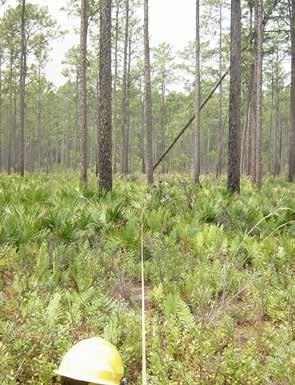
16 Fire Behavior and Fire Effects The descriptions of fire behavior and effects below were based on an initial rapid assessment. Videos were preliminary assessed visually, and the estimates might change in the future with more detailed digital analysis of the imagery. Pocosin (site 2) Site 2 burned as a low intensity surface fire with flame lengths estimated at 5 from the video (Figure 3). Fuel consumption on this shrubby site was nearly 100%, with stems reduced to less than 1inch in height. Figure 3. Fire burning toward site 2 (left photo) and then fire in the site (right photo). 16

, but high consumption of understory shrubs.")
.")

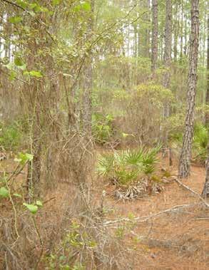
17 Pond Pine-Sweet Bay (Sites 1 and 3) Both sites 1 and 3 burned as part of a suppression burnout operation. At site 1, the fire burned as a low intensity surface fire that backed through the site. Flame lengths were estimated at 1 foot from the video (Figure 5). There was no crown scorch or consumption (torch), but high consumption of understory shrubs. Remaining stems were reduced to less than 5 inches in height. Site 3, also burned as a low intensity surface fire, with flame lengths estimated at 4 feet from the video (Figure 4). There was little crown scorch in the overstory tree layer, but midstory trees had heavy (75%) to complete (100%) scorch. In the understory, there was heavy scorch and moderate to high, but not complete, consumption. Figure 4. Fire burning through site 3 (photo on left) and later lingering combustion (photo on right). Figure 5. Fire burning through site 1 (left photo) and post-fire at the same site (right photo). 17
. Understory shrubs were scorched but with little consumption.")
. Site 12 burned partially as a backing fire but site 13 burned as a head fire.")
 and site 13 high crown scorch (100%).")
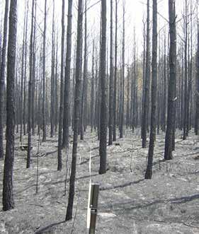
18 Natural Slash Pine Stands (Sites 11, 12, 13) These sites burned as low, moderate and high intensity surface fires. Site 11 burned as a low intensity surface fire at night. Flame lengths were estimated at 1 foot from the video, with very slow rates of spread at less than 1 chain per hour (Figure 6). Understory shrubs were scorched but with little consumption. The dense layer of sedges in the understory was almost totally consumed but the underlying moss had little change. Sites 12 and 13 burned as moderate to high intensity surface fires during the day (Figures 7 and 8). Site 12 burned partially as a backing fire but site 13 burned as a head fire. Flame lengths at site 12 were estimated at 6 feet from the video. At site13 flame lengths were estimated at 15 from the video. Neither of the stands had overstory crown consumption. Site 12 had moderate to high crown scorch (60-95%) and site 13 high crown scorch (100%). At both sites there was heavy consumption of the understory with only stobs of shrubs and stems of palmetto remaining. Figure 6. Site 11 burning at night. Figure 7. Fire burning toward site 13. Figure 8. Low intensity flanking fire (left photo) and head fire (right photo) in site
.")
 were estimated at between 7-12 feet (Figures 11 and 12).")
. Figure 9.")
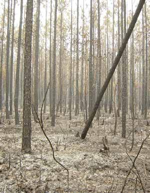
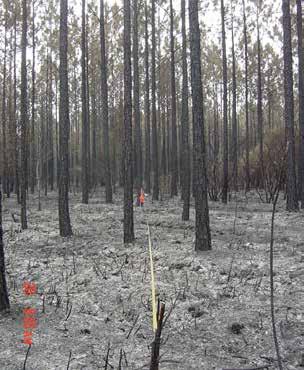
19 Slash Pine Plantations (Sites 5, 7, 8, 9, 10) Three of the pine plantation sites burned as high intensity surface fires (sites 7, 8, 9) and two as crown fires. Site 5 exhibited crown fire (all crowns consumed, Figures 9 and 10). Site 10 had extensive torching (half of trees in plot had crowns consumed). Flame lengths at the sites that burned as high intensity surface fires (sites 7, 8, 9) were estimated at between 7-12 feet (Figures 11 and 12). Site 7 burned with the greatest rate of spread (estimated at 60 chains per hour from the video, and 30 to 115 chains per hour from sensors) and had no overstory tree crown scorch. Sites 8 and 9 burned with slower spread rates (estimated 4-7 chains per hour from video). Figure 9. Spots starting in site 5 (left photo) and coalescing (right photo). Figure 10. After spots have coalesced and merged with main head fire at site 5. 19


")
.")
20 Figure 11. Fire burning through site 8. Figure 12. Fire burning in site 7 (left photo) and site 9 (right photo). 20
21 Table 8. Fire behavior measurements and observations by site. Note site 4 and 6 did not burn. Site Fire Type Fire Behavior Flame length (feet) Rate of Spread (chains/hr) Flame Duration across site (from video) Temperature ( 0 F) open pond pine (swamp) 2 low intensity surface head fire (firing operation) to 2 1 min pond pine low intensity surface backing fire (firing operation) to min. 389 low intensity surface backing fire (firing operation) to 6 41 min. not measured natural slash pine (swamp) night time, mainly low intensity surface fire flanking and backing to 3 1 hr 11min. not measured moderate intensity surface flanking fire and also head fire (initially flanking/ backing then head to 5 17 min fire came from behind camera) 13 high intensity surface head fire to min slash pine plantation Above view of Abandoned site 5 Spot fires in front of camera that coalesced with a head fire and turned into a crown fire camera, above trees before sensors placed, video 21 min. not measured (>50) difficult to interpret 7 high intensity surface head fire 7 29 to min high intensity surface flanking fire 7 4 to min high intensity surface fire, both backing & head fire that met in view of camera high intensity surface fire with extensive torching (50% of trees) to 4 9 min to min. not measured 21
22 Post-fire Consumption and Immediate Effects The fire effects were measured and observed post-fire, immediately after consumption ended. The effects reported here included dead fuel consumption, crown scorch and consumption by vegetation layer (overstory tree, midstory tree, shrub, grass) and changes in soil color and cover (Tables 5, 9, 10). It was not possible to determine tree mortality or mortality of understory plants that may resprout so soon after the fire. Table 9. Soil severity rating (USDI National Park Service 2001). Soil severity rating Site Very high (1) High (2) Moderate (3) Low (4) Unburned (5) (% of site) open pond pine (swamp) 2 100% pond pine 3 85% 15% 1 25% 75% natural slash pine (swamp) 11 5% 35% 45% 5% natural slash pine - recent prescribed fire 12 95% 5% 13 95% 5% slash pine plantation 6 Site disrupted by tractor % 85% 5% 7 5% 80% 5% 8 5% 75% 15% 9 100% 10 75% 25% 1- very high, white ash, some discoloration of soil; 2 high, gray and black ash; 3 moderate, ash and some patches of charred litter or duff; 4 low severity, charred litter and some unburned litter and duff remain; 5 unburned. 22
23 Table 10. Summary of immediate post fire effects per site. Mortality was not included, since survival would not be determined immediately post-fire. Trees that were scorched can survive. Data below lists torch, where needles are consumed, and scorch, where needles are brown but not consumed. Results below were based upon a rapid analysis of measured crown scorch and torch. Detailed data by individual tree was recorded but was not summarized quantitatively at this time. Site 2 Summary of immediate post fire effects Understory Midstory Trees Overstory Trees Grass/herb /ferns/moss Shrubs Tree seedlings Scorch (% crown) open pond pine (swamp) 100% cons. ferns, moss little affected 3 none in plot 1 none in plot % grass consumption, moss consumption <20% 100% cons. leaves and some stems 100% foliage consumption for singe pond pine pond pine Torch (% crown) % scorch and 20-90% cons. 100% scorch Scorch (% crown) Torch (% crown) Mean char height (feet) mostly 0, few % scorch, 20-80% cons. leaves and some stems n/a natural slash pine (swamp) 100% scorch and 20% consumption n/a natural slash pine - recent prescribed fire % consumption 90% consumption n/a n/a % consumption 90% consumption n/a slash pine plantation 5 n/a 100% cons. leaves and % stems n/a % cons. foliage 100% consumed 7 n/a 8 n/a 100% consumption of 9 grass 10 n/a and 50% stems (red maple) % 100% consumed half 0, half consumption (red maple) % consumption none in plot & % half <15, half half 0, half consumption none in plot


24 Detailed pre- and post-fire photos grouped by vegetation type Open pond pine-swamp (Site 2) Pond Pine (Sites 1 and 3, presented in that order) 24


25 Natural Slash Pine (Sites 11, 12, 13, presented in that order) 25

26 26


27 Slash Pine Plantations (Sites 5, 7, 8, 9, 10, presented in that order) 27


28 28

29 29
30 References Edwards, M.B., and McNab, W.H Table for estimating fuel loading in slash and longleaf pine stands. Southeastern Forest Experiment Station, Forest Service, U.S. Dept. of Agriculture, Asheville, NC. Carleton, D Fire Management Analyst (FMA) Plus software version Fire Program Solutions, LLC (Don Carlton), Sandy, Oregon. Hough, W.A., and Albini, R.D Predicting fire behavior in palmetto-gallberry fuel complexes. U.S. Department of Agriculture, Forest Service Southereastern Forest Experiment Station, Forest Service Research Paper SE-174. Asheville, NC. Ottmar, R.D. and Andreu Litter and Duff Bulk Densities in the Southern United States. Joint Fire Science Final Report # Ottmar, R.D., and Vihnanek, R.E. 2000, Stereo photo series for quantifying natural fuels: Volume VI: longleaf pine, pocosin, and marshgrass types in the Southeast United States.. PMS 835. NFES Boise, Idaho: National Wildfire Coordinating Group. National Interagency Fire Center.. Sigma Delta Technologies RASP-150 (Rate of Spread of Fire monitor), Operator Manual, Floreat, Australia. Simard, A.J., Deacon, A.G., and Adams, K.B Nondirectional sampling of wildland fire spread. Fire Technology. Springer Netherlandsw, Vol.18, No. 3, August United States Department of Interior National Park Service (USDI) Fire Monitoring Handbook. Boise, ID.. National Interagency Fire Center. 30
31 Appendix A. About the Fire Behavior Assessment Team We are a unique module that specializes in measuring fire behavior on active fires of all kinds including wildland fire use fires, prescribed fires or wildfires. We utilize fire behavior sensors and special video camera set-ups to measure direction and variation in rate of spread, fire type (e.g. surface, passive or active crown fire behavior) in relation to fuel loading and configuration, topography, fuel moisture, weather and operations. We measure changes in fuels from the fire and can compare the effectiveness of past fuel treatments or fires on fire behavior and effects. We are prepared to process and report data while on the incident, which makes the information immediately applicable for verifying LTAN or FBAN fire behavior prediction assumptions. In addition, the video and data are useful for conveying specific information to the public, line officers and others. We can also collect and analyze data to meet longer term management needs such as verifying or testing fire behavior modeling assumptions for fire management plans, unit resource management plans or project plans. We are team of fireline qualified technical specialists and experienced fire overhead. The overhead personnel includes a minimum of crew boss and more often one or more division supervisor qualified persons. The team can vary in size, depending upon availability and needs of order, from 5 to 12 persons. We have extensive experience in fire behavior measurements during wildfires, wildland fire use fires and prescribed fires, having worked safely and effectively with over 16 incident management teams. We can be ordered from ROSS and can reach us through Tahoe NF dispatch, Do not assume that we are not available if you call dispatch and we are already on a fire. We have and can work more than one fire simultaneously and may be ready for remobilization. 31
Wildfire Damage Assessment for the 2011 Southeast Complex Fires
 Wildfire Damage Assessment for the 2011 Southeast Complex Fires Chip Bates & Mark McClure, Forest Health Management Background: On March 24, 2011, multiple wildfires began across southeast Georgia. Strong,
Spatial Tools for Wildland Fire Management Planning
 Spatial Tools for Wildland Fire Management Planning M A. Finney USDA Forest Service, Fire Sciences Laboratory, Missoula MT, USA Abstract Much of wildland fire planning is inherently spatial, requiring
Post-Wildfire Clean-Up and Response in Houston Toad Habitat Best Management Practices
 Post-Wildfire Clean-Up and Response in Houston Toad Habitat Best Management Practices Purpose The purpose of this document is to provide guidance and recommendations for minimizing potential impacts to
6. NATURAL AREAS FIRE MANAGEMENT
 6. NATURAL AREAS FIRE MANAGEMENT 6-1 Wildfire management is an important component of managing and maintaining County natural areas. The natural areas are woven into the community fabric and are a part
Wildland Fire Decision Support Tools
 Wildland Fire Decision Support Tools Numerous support tools for intelligence gathering and analyses are readily available to aid fire managers and administrators in making risk informed decisions. These
Your Defensible Space Slideshow
 Your Defensible Space Slideshow Red = Trees to Remove Your Defensible Space Slideshow This slideshow was created to highlight actions you can take to dramatically improve the chances of your home surviving
King Fire Restoration Project, Eldorado National Forest, Placer and El Dorado Counties, Notice of intent to prepare an environmental impact statement.
 This document is scheduled to be published in the Federal Register on 12/24/2014 and available online at http://federalregister.gov/a/2014-30158, and on FDsys.gov [3410-11- P] DEPARTMENT OF AGRICULTURE
Standard Fire Behavior Fuel Models: A Comprehensive Set for Use with Rothermel s Surface Fire Spread Model
 United States Department of Agriculture Forest Service Rocky Mountain Research Station General Technical Report RMRS-GTR-153 June 2005 Standard Fire Behavior Fuel Models: A Comprehensive Set for Use with
Assume you have 40 acres of forestland that was
 A l a b a m a A & M a n d A u b u r n U n i v e r s i t i e s ANR-1371 Basal Area: A Measure Made for Management Assume you have 40 acres of forestland that was recently assessed by a natural resource
National Hazard and Risk Model (No-HARM) Wildfire
 Wildfire") National Hazard and Risk Model (No-HARM) Wildfire A Briefing Paper Anchor Point Group LLC 2131 Upland Ave. Boulder, CO 80304 (303) 665-3473 www.anchorpointgroup.com Summary The potential for wildfire-caused
National Hazard and Risk Model (No-HARM) Wildfire A Briefing Paper Anchor Point Group LLC 2131 Upland Ave. Boulder, CO 80304 (303) 665-3473 www.anchorpointgroup.com Summary The potential for wildfire-caused
Deer Exclusion Effects on Understory Development Following Partial Cutting in a Pennsylvania Oak Stand
 Deer Exclusion Effects on Understory Development Following Partial Cutting in a Pennsylvania Oak Stand Larry H. McCormick 1/, John W. Groninger 2/, Kathy A. Penrod 1/, and Todd E. Ristau 1/ Abstract: Forty
Consume 3.0 Tutorial INSTRUCTOR S GUIDE
 Consume 3.0 Tutorial INSTRUCTOR S GUIDE To download and/or view the Consume 3.0 tutorial, please visit the tutorial webpage at: http://www.fs.fed.us/pnw/fera/products/software_tutorials.html The Consume
Fuels Treatments Reduce Wildfire Suppression Cost Merritt Island National Wildlife Refuge May 2012
 Fuels Treatments Reduce Wildfire Suppression Cost Merritt Island National Wildlife Refuge May 2012 Merritt Island National Wildlife Refuge Where Technology and Nature Intersect Authors Jennifer Hinckley
Fire Prescriptions. for Maintenance and Restoration of Native Plant Communities
 Oklahoma Cooperative Extension Service NREM-2878 Fire Prescriptions for Maintenance and Restoration of Native Plant Communities Terrence G. Bidwell Professor and Extension Specialist Rangeland Ecology
Response Levels and Wildland Fire Decision Support System Content Outline
 Response Levels and Wildland Fire Decision Support System Content Outline In wildland fire management, practitioners are accustomed to levels of incident management, initial attack response, dispatch levels,
Standard Fire Behavior Fuel Models: A Comprehensive Set for Use with Rothermel s Surface Fire Spread Model
 United States Department of Agriculture Forest Service Rocky Mountain Research Station General Technical Report RMRS-GTR-153 June 2005 Standard Fire Behavior Fuel Models: A Comprehensive Set for Use with
Wildfires pose an on-going. Integrating LiDAR with Wildfire Risk Analysis for Electric Utilities. By Jason Amadori & David Buckley
 Figure 1. Vegetation Encroachments Highlighted in Blue and Orange in Classified LiDAR Point Cloud Integrating LiDAR with Wildfire Risk Analysis for Electric Utilities Wildfires pose an on-going hazard
Fire Prescriptions. for Maintenance and Restoration of Native Plant Communities NREM-2878
 Oklahoma Cooperative Extension Service NREM-2878 Fire Prescriptions for Maintenance and Restoration of Native Plant Communities Terrence G. Bidwell Professor and Extension Specialist Rangeland Ecology
weather information management system / remote automated weather station
 weather information management system / remote automated weather station (wims/raws) OpERATIONS GUIDE wyoming blm June 2010 Table of Contents INTRODUCTION... ROLES AND RESPONSIBILITIES... A. District Manager...
Analysis of Wildfire Likelihood and Opportunities For Mitigation in the Chornobyl Forestscape
 Analysis of Wildfire Likelihood and Opportunities for Mitigation in the Chernobyl Irradiated Forests By James McCarter, Sergiy Zibtsev, Aaron Hohl, Mykhaylo Petrenko LMS Portfolios The Landscape Management
Tree and forest restoration following wildfire
 Peter F. Kolb (PhD) MSU Extension Forestry Specialist Adj. Assistant Professor Forest Ecology School of Forestry, University of Montana, Missoula, MT 59808 Tel. (406) 243-4705, e-mail: efpfk@forestry.umt.edu
Chipping, Burning, and the Care of Southeastern Pine Woodlands
 Treating fi re-excluded pine woodlands with chipping and burning may be valuable restoration tools under some circumstances, but they are inappropriate tools for high-quality longleaf pine woodland, as
Comparison of Satellite Imagery and Conventional Aerial Photography in Evaluating a Large Forest Fire
 Purdue University Purdue e-pubs LARS Symposia Laboratory for Applications of Remote Sensing --98 Comparison of Satellite Imagery and Conventional Aerial Photography in Evaluating a Large Forest Fire G.
Financial maturity is when the rate of value
 Cutting at Financial Maturity: Maximizing the economic return of your woodland Woodland owners harvest trees for financial and personal reasons. Deciding when is the optimal time to harvest is difficult
This document provides direction for the Great Basin and supplements the Interagency Incident Business Management Handbook, PMS-902.
 GREAT BASIN COORDINATING GROUP INTERAGENCY INCIDENT BUSINESS MGMT HANDBOOK SUPPLEMENT This document provides direction for the Great Basin and supplements the Interagency Incident Business Management Handbook,
Gaining A Basic Understanding. of the. National Fire Danger Rating System. A Self-Study Reading Course. Final Draft Pending Review and Approval by
 A Publication of the National Wildfire Coordinating Group Sponsored by United States Department of Agriculture United States Department of Interior National Association of State Foresters Gaining A Basic
Table A1. To assess functional connectivity of Pacific marten (Martes caurina) we identified three stand types of interest (open,
 we identified three stand types of interest (open,") Supplemental Online Appendix Table A1. To assess functional connectivity of Pacific marten (Martes caurina) we identified three stand types of interest (open, simple, complex) but divided these into subclasses
Supplemental Online Appendix Table A1. To assess functional connectivity of Pacific marten (Martes caurina) we identified three stand types of interest (open, simple, complex) but divided these into subclasses
Developing a Prescribed Fire Burn Plan: ELEMENTS & CONSIDERATIONS
 Developing a Prescribed Fire Burn Plan: ELEMENTS & CONSIDERATIONS What s Inside PURPOSE OF A BURN PLAN Goals and Objectives 3 Burn Site Information 3 Site Preparation 3 Prescription 3 Ignition and Holding
Landscaping with Ornamental Trees and Exterior Structure Features Using EcoSmart Fire Model
 Landscaping with Ornamental Trees and Exterior Structure Features Using EcoSmart Fire Model Mark A. Dietenberger, Ph.D., USDA, FS, Forest Products Laboratory, Madison, Wisconsin, USA, mdietenberger@fs.fed.us
Testimony of Diane Vosick, Director of Policy and Partnerships
 Testimony of Diane Vosick, Director of Policy and Partnerships The Ecological Restoration Institute, Northern Arizona University http://www.eri.nau.edu/ Before the House Federal Lands Subcommittee April
Fighting Fire with Fire: Can Fire Positively Impact an Ecosystem?
 Fighting Fire with Fire: Can Fire Positively Impact an Ecosystem? Science Topic: Fire Ecology Grades: 6 th 8 th Essential Questions: What role does fire play in maintaining healthy ecosystems? How does
THE ECOSYSTEM - Biomes
 Biomes The Ecosystem - Biomes Side 2 THE ECOSYSTEM - Biomes By the end of this topic you should be able to:- SYLLABUS STATEMENT ASSESSMENT STATEMENT CHECK NOTES 2.4 BIOMES 2.4.1 Define the term biome.
COMPENSATION-FOR-INJURY MANAGER (INJR)
") A Publication of the National Wildfire Coordinating Group Sponsored by United States Department of Agriculture United States Department of the Interior NATINAL INTERAGENCY INCIDENT MANAGEMENT SYSTEM TASK
A Publication of the National Wildfire Coordinating Group Sponsored by United States Department of Agriculture United States Department of the Interior NATINAL INTERAGENCY INCIDENT MANAGEMENT SYSTEM TASK
Are My. Pine Trees. Ready To Thin?
 Are My Pine Trees Ready To Thin? ARE MY PINE TREES READY TO THIN? One question private forest landowners ask most frequently is, Are my pine trees ready to thin? There is no definite answer to this question,
Fireline Rehabilitation on Donnelly Flats fire (B222) Summary: 7/1/99 R.R. Jandt
 Summary: 7/1/99 R.R. Jandt") Fireline Rehabilitation on Donnelly Flats fire (B222) Summary: 7/1/99 R.R. Jandt Assessment- During the suppression effort approximately 20-25 miles of bladed fireline was built using D-8-equivalent dozers.
Fireline Rehabilitation on Donnelly Flats fire (B222) Summary: 7/1/99 R.R. Jandt Assessment- During the suppression effort approximately 20-25 miles of bladed fireline was built using D-8-equivalent dozers.
9 - Wildland Fire Decision Support System Overview. S-590 Advanced Fire Behavior Interpretation
 INSTRUCTOR: LESSON: 9 - Wildland Fire Decision Support System Overview COURSE: S-590 Advanced Fire Behavior Interpretation Emphasis: introduce concepts of WFDSS decision support and available models and
A Land Manager s Guide for Creating Fire-Resistant Forests
 A Land Manager s Guide for Creating Fire-Resistant Forests Stephen Fitzgerald and Max Bennett Photo by Stephen Fitzgerald Oregon State University EM 9087 EM 9087 September 2013 A Land Manager s Guide for
Life Cycle Of A Plant Population
 Life Cycle Of A Plant Population Seed Rain n=3 Growth And Mortality n=7 Seedling Cohort n=22 Environmental Sieve Seed Bank n=5 Copyright G. Bonan 22 Suvivorship Of Seedlings In A Northern Hardwood Forest
FREQUENTLY ASKED QUESTIONS Biomass Harvest Guidelines
 FREQUENTLY ASKED QUESTIONS Biomass Harvest Guidelines What do Biomass Harvest Guidelines offer? They offer recommendations to manage forest-, brush- and open- land with the intent to protect water, timber,
Forest Watershed Tree Thinning Restoration Effectiveness Monitoring in the Manzano Mountains of New Mexico
 Forest Watershed Tree Thinning Restoration Effectiveness Monitoring in the Manzano Mountains of New Mexico By David Lightfoot 1,2, Cody Stropki 1, Victoria Amato 1 and Anne Russell 1 1 SWCA Environmental
Managing Fire Dependent Wildlife Habitat without Fire. A Land Management Practice That: 100 Years of Fire Suppression in Ponderosa pine ecosystems
 Managing Fire Dependent Wildlife Habitat without Fire Dale Swedberg Chairman North Central Washington Prescribed Fire Council Land Management Practices used to Manage Wildlife Habitat A Land Management
Wildland Fire Primer. A Guide for Educators. U.S. Department of the Interior Bureau of Land Management
 Wildland Fire Primer A Guide for Educators U.S. Department of the Interior Bureau of Land Management 2002 2003 Wildland Fire Primer A Guide for Educators 2002 2003 Prepared by: John Owens Pat Durland National
Fire, Forest History, and Ecological Restoration of Ponderosa Pine Forests at Mount Rushmore, South Dakota
 Fire, Forest History, and Ecological Restoration of Ponderosa Pine Forests at Mount Rushmore, South Dakota Restoration uses the past not as a goal but as a reference point for the future...it is not to
GROWTH POTENTIAL OF LOBLOLLY PINE PLANTATIONS IN THE GEORGIA PIEDMONT: A SPACING STUDY EXAMPLE
 GROWTH POTENTIAL OF LOBLOLLY PINE PLANTATIONS IN THE GEORGIA PIEDMONT: A SPACING STUDY EXAMPLE Plantation Management Research Cooperative Daniel B. Warnell School of Forest Resources University of Georgia
How To Manage A Forest Service Plant Data On A Safari
 FIREMON Database User Manual John F. Caratti SUMMARY The FIREMON database software allows users to enter data, store, analyze, and summarize plot data, photos, and related documents. The FIREMON database
The Importance of Garbage Clearing and vegetation
 BHFD Fire Prevention Bureau 445 North Rexford Drive Beverly Hills, CA 90210 2014 BEVERLY HILLS FIRE DEPARTMENT Beverly Hills Fire Department BRUSH CLEARANCE PROGRAM INFORMATION BROCHURE Your property is
Summary of Pre- and Post-Project Vegetation Survey Results
 3921 East Bayshore Road Palo Alto CA 94303-4326 tel 650.962.9876 fax 650.962.8234 www.acterra.org info@acterra.org Introduction Summary of Pre- and Post-Project Vegetation Survey Results Acterra Stewardship
MINIMUM QUALIFICATION STANDARDS
 MINIMUM QUALIFICATION STANDARDS SENIOR FIREFIGHTER (advanced level firefighter with specialized skills and knowledge) OPM Standard Requirements - GS-455/462 Technician Series One year of specialized experience
Forest Management Guidelines for the Protection of Four-toed and Spotted Salamander Populations Carol Hall & Bruce Carlson May 2004
 Forest Management Guidelines for the Protection of Four-toed and Spotted Salamander Populations Carol Hall & Bruce Carlson May 2004 Salamander Natural History Four-toed Salamanders: The Four-toed Salamander,
Photo courtesy of the National Wild Turkey Federation NON-GAME GAME
 FORESTS AND WILDLIFE Wildlife and forest management are not only compatible, but are interrelated. Developing an active forest resource management plan allows you to place a special emphasis on wildlife
Fence Row Herbicide Evaluation: Efficacy of Control
 Publication Number 003R-07 December 2007 Fence Row Herbicide Evaluation: Efficacy of Control Jim Crawford, David Dickens, David Moorhead, Bryan McElvany, and Kris Irwin 1 OBJECTIVE The objective of this
Habitat Management Techniques Flatwoods Salamander. USFWS Recommendations
 Habitat Management Techniques Flatwoods Salamander USFWS Recommendations Habitat Management Techniques to Benefit the Flatwoods Salamander. These techniques are the most current recommendations that the
Urban Tree Planting Quantification Guidance
 Urban Tree Planting Quantification Guidance June 2014 This document provides guidance for quantifying an Urban Tree Planting (UTP) Project s carbon stocks, both for purposes of estimating a project s baseline
HURRICANE IVAN Damage Appraisal & Recovery Efforts. Presentation produced by AFC (Walter E. Cartwright) WEB Address: www.forestry.alabama.
 WEB Address: www.forestry.alabama.") HURRICANE IVAN Damage Appraisal & Recovery Efforts Presentation produced by AFC (Walter E. Cartwright) WEB Address: www.forestry.alabama.gov Hurricane Ivan Struck 2:30 AM September 16, 2004 130 MPH winds
HURRICANE IVAN Damage Appraisal & Recovery Efforts Presentation produced by AFC (Walter E. Cartwright) WEB Address: www.forestry.alabama.gov Hurricane Ivan Struck 2:30 AM September 16, 2004 130 MPH winds
Photogrammetric Point Clouds
 Photogrammetric Point Clouds Origins of digital point clouds: Basics have been around since the 1980s. Images had to be referenced to one another. The user had to specify either where the camera was in
GREEN SHEET. California Department of Forestry and Fire Protection
 GREEN SHEET California Department of Forestry and Fire Protection Informational Summary of Serious CAL FIRE Injuries, Illnesses, Accidents & Near-Miss Incidents Pine Fire Wildland Fire Entrapment & Burn-Over
Natural Air Drying Corn Paul E. Sumner University of Georgia Biological and Agricultural Engineering Department
 Natural Air Drying Corn Paul E. Sumner University of Georgia Biological and Agricultural Engineering Department Many small farmers prefer to dry crops using unheated or natural air drying in bins in layers
Determining the relative resistance of selected Pinus species to fire damage
 Forest Fire Research & Wildland Fire Safety, Viegas (ed.) 2002 Millpress, Rotterdam, ISBN 90-77017-72-0 Determining the relative resistance of selected Pinus species to fire damage C. de Ronde Silva Forest
Calculation of Liquefied Natural Gas (LNG) Burning Rates
 Burning Rates") Calculation of Liquefied Natural Gas (LNG) Burning Rates Carolina Herrera, R. Mentzer, M. Sam Mannan, and S. Waldram Mary Kay O Connor Process Safety Center Artie McFerrin Department of Chemical Engineering
Calculation of Liquefied Natural Gas (LNG) Burning Rates Carolina Herrera, R. Mentzer, M. Sam Mannan, and S. Waldram Mary Kay O Connor Process Safety Center Artie McFerrin Department of Chemical Engineering
Monitoring of Forest Thinning Treatments and Wildfire Effects on Forest and Watershed Health in the Manzano Mountains, New Mexico
 Monitoring of Forest Thinning Treatments and Wildfire Effects on Forest and Watershed Health in the Manzano Mountains, New Mexico By David Lightfoot, Victoria Amato, and Cody Stropki SWCA Environmental
After Wildfire. Section 4. Tree and Forest Restoration Following Wildfire
 After Wildfire Section 4 Tree and Forest Restoration Following Wildfire Peter F. Kolb, Extension Forestry Specialist, Montana State University School of Forestry, University of Montana After a wildfire
Protecting Tree Plantations From Fire in Hawai i
 Forest and Natural Resource Management April 2014 RM-18 Protecting Tree Plantations From Fire in Hawai i Bryon Stevens 1, J. B. Friday 2, Doug Cram 2, Clay Trauernicht 2 1 Hawai i DLNR Division of Forestry
Nuts and bolts of BAER soil and watershed assessments
 27 Nuts and bolts of BAER soil and watershed assessments MARSHA DAVIS, National Park Service Columbia Cascades Support Office, 909 First Avenue, Seattle, Washington 98104; marsha_davis@nps.gov CHRIS HOLBECK,
Wildland Fire Position Descriptions
 Wildland Fire Position Descriptions This document gives brief position descriptions. The career tracks and career timelines are color coded to the Fire Management Career Ladders graphic. Operations Early
The UK Timber Resource and Future Supply Chain. Ben Ditchburn Forest Research
 The UK Timber Resource and Future Supply Chain Ben Ditchburn Forest Research Timber availability The landscape of timber availability in Great Britain and the United Kingdom is moving through a period
EAST BAY REGIONAL PARK DISTRICT FIRE DEPARTMENT POINT PINOLE GRASSLAND RESTORATION PRESCRIBED FIRE AND SMOKE MANAGEMENT PLAN
 EAST BAY REGIONAL PARK DISTRICT FIRE DEPARTMENT POINT PINOLE GRASSLAND RESTORATION PRESCRIBED FIRE AND SMOKE MANAGEMENT PLAN February 11, 2014 TABLE OF CONTENTS Section 1 REVIEW AND APPROVAL 2 Section
2002 URBAN FOREST CANOPY & LAND USE IN PORTLAND S HOLLYWOOD DISTRICT. Final Report. Michael Lackner, B.A. Geography, 2003
 2002 URBAN FOREST CANOPY & LAND USE IN PORTLAND S HOLLYWOOD DISTRICT Final Report by Michael Lackner, B.A. Geography, 2003 February 2004 - page 1 of 17 - TABLE OF CONTENTS Abstract 3 Introduction 4 Study
Angora Fire Restoration Activities June 24, 2007. Presented by: Judy Clot Forest Health Enhancement Program
 Angora Fire Restoration Activities June 24, 2007 Presented by: Judy Clot Forest Health Enhancement Program California Tahoe Conservancy Independent California State Agency within the Resources Agency Governed
BehavePlus fire modeling system Version 4.0. User s Guide
 United States Department of Agriculture Forest Service Rocky Mountain Research Station General Technical Report RMRS-GTR-106WWW Revised July, 2008 BehavePlus fire modeling system Version 4.0 User s Guide
LAB #12 Introduction to Forest Inventory Software
 SUBJECT: LAB #12 Introduction to Forest Inventory Software Forest Inventory software programs simplify field data entry and data management, as well as allow users to efficiently derive summary volume
SANTA BARBARA COUNTY COMPREHENSIVE PLAN LOMPOC AREA
 SANTA BARBARA COUNTY COMPREHENSIVE PLAN LOMPOC AREA A. LAND USE ELEMENT INTERPRETIVE GUIDELINES B. COMMUNITY BENEFITS C. COUNTY ACTION ITEMS Adopted by the Board of Supervisors November 9, 1999 A. Santa
Integrated Weed Management in Portland Parks
 Urban Pest Management Course February 6, 2013 Integrated Weed Management in Portland Parks Commissioner Nick Fish www.portlandparks.org Director Mike Abbaté Commissioner www.portlandparks.org Jim Francecsconi
ORDERING MANAGER (ORDM)
") A Publication of the National Wildfire Coordinating Group Sponsored by United States Department of Agriculture United States Department of the nterior NATNAL NTERAGENCY NCDENT MANAGEMENT SYSTEM TASK BK
A Publication of the National Wildfire Coordinating Group Sponsored by United States Department of Agriculture United States Department of the nterior NATNAL NTERAGENCY NCDENT MANAGEMENT SYSTEM TASK BK
Prescribed Fire as the Minimum Tool for Wilderness Forest and Fire Regime Restoration: A Case Study from the Sierra Nevada, CA. Abstract.
 Prescribed Fire as the Minimum Tool for Wilderness Forest and Fire Regime Restoration: A Case Study from the Sierra Nevada, CA MaryBeth Keifer, Nathan L. Stephenson and Jeff Manley Abstract Changes in
Image Analysis CHAPTER 16 16.1 ANALYSIS PROCEDURES
 CHAPTER 16 Image Analysis 16.1 ANALYSIS PROCEDURES Studies for various disciplines require different technical approaches, but there is a generalized pattern for geology, soils, range, wetlands, archeology,
Restoration of Fire-adapted Ecosystems in the Central and Southern Appalachians
 Restoration of Fire-adapted Ecosystems in the Central and Southern Appalachians Marek Smith The Nature Conservancy 12181-A Courthouse Hill Road Warm Springs, VA 24484 marek_smith@tnc.org Sam Lindblom The
Hazardous Fuels Treatment Effectiveness on Utah BLM Lands
 Hazardous Fuels Treatment Effectiveness on Utah BLM Lands J. Bradley Washa - State Fuels Specialist, Utah State Office, DOI Bureau of Land Management Since inception of the National Fire Plan, 112 hazardous
Communities, Biomes, and Ecosystems
 Communities, Biomes, and Ecosystems Before You Read Before you read the chapter, respond to these statements. 1. Write an A if you agree with the statement. 2. Write a D if you disagree with the statement.
18 voting members 44 stakeholders 114 email list. Senators: Wyden & Merkley Representative DeFazio
 18 voting members 44 stakeholders 114 email list Senators: Wyden & Merkley Representative DeFazio State Representative Krieger State Senators: Roblan, Johnson, and Kruse Governor Brown s office County
FORESTED VEGETATION. forests by restoring forests at lower. Prevent invasive plants from establishing after disturbances
 FORESTED VEGETATION Type of strategy Protect General cold adaptation upland and approach subalpine forests by restoring forests at lower Specific adaptation action Thin dry forests to densities low enough
Loading Productivity of Untrimmed and Trimmed Pulpwood
 Loading Productivity of Untrimmed and Trimmed Pulpwood Jason Thompson 1, John Klepac 1, and Dana Mitchell 2 1 Engineer, Forest Operations Research Unit, Southern Research Station, USDA Forest Service 2
Units of Measure and Conversion Factors for Forest Products
 Units of Measure and Conversion Factors for Forest Products Bulletin #7103 Knowledge of the common units of wood measurement is important to people who are involved in marketing forest products. These
Hazard Identification and Risk Assessment
 Wildfires Risk Assessment This plan is an update of the 2004 City of Redmond Hazard Mitigation Plan (HMP). Although it is an update, this document has been redesigned so that it looks, feels, and reads
Lesson 9: Introduction to the Landscape Management System (LMS)
") Lesson 9: Introduction to the Landscape Management System (LMS) Review and Introduction In earlier lessons, you learned how to establish and take measurements in sample inventory plots. In Lesson 8, you
Lesson 9: Introduction to the Landscape Management System (LMS) Review and Introduction In earlier lessons, you learned how to establish and take measurements in sample inventory plots. In Lesson 8, you
Lidar Remote Sensing for Forestry Applications
 Lidar Remote Sensing for Forestry Applications Ralph O. Dubayah* and Jason B. Drake** Department of Geography, University of Maryland, College Park, MD 0 *rdubayah@geog.umd.edu **jasdrak@geog.umd.edu 1
Background research on the topic of urban forestry is intended to
 overview urban forestry Urban Forestry Background research on the topic of urban forestry is intended to help guide the task of integrating trees and urban forestry goals and aspirations into the Portland
FWRC. Cooperators: Delta Wildlife, Inc. Forest and Wildlife Research Center, Mississippi State University
 Cooperators: Delta Wildlife, Inc. Forest and Wildlife Research Center, Mississippi State University Mississippi Department of Wildlife, Fisheries and Parks Mississippi Fish and Wildlife Foundation Mississippi
Wildlifer 2013 Managing Wildlife on Private Lands
 Master Wildlifer 2013 Managing Wildlife on Private Lands Greg Yarrow, Chair and Professor Natural Resources School of Agricultural, Forest, & Environmental Sciences Clemson University Clemson, South Carolina,
FIELD VALIDATION OF BURNED AREA REFLECTANCE CLASSIFICATION (BARC) PRODUCTS FOR POST FIRE ASSESSMENT
 PRODUCTS FOR POST FIRE ASSESSMENT") FIELD VALIDATION OF BURNED AREA REFLECTANCE CLASSIFICATION (BARC) PRODUCTS FOR POST FIRE ASSESSMENT Andrew T. Hudak, Research Forester Peter R. Robichaud, Research Engineer Jeffrey S. Evans, Biologist/GIS
FIELD VALIDATION OF BURNED AREA REFLECTANCE CLASSIFICATION (BARC) PRODUCTS FOR POST FIRE ASSESSMENT Andrew T. Hudak, Research Forester Peter R. Robichaud, Research Engineer Jeffrey S. Evans, Biologist/GIS
SUPPLEMENTAL QUALIFICATION STANDARD FOR THE U.S. DEPARTMENT OF AGRICULTURE - FOREST SERVICE
 Attachment 1 SUPPLEMENTAL QUALIFICATION STANDARD FOR THE U.S. DEPARTMENT OF AGRICULTURE - FOREST SERVICE U.S. DEPARTMENT OF THE INTERIOR - BUREAU OF INDIAN AFFAIRS, BUREAU OF LAND MANAGEMENT, FISH AND
Begin forwarded message:
 From: To: Subject: Date: Attachments: Heather Scott Tully, Tania Fwd: Stalite Root Bridge Tuesday, November 17, 2015 8:58:01 AM Stalite_Root_Bridge_brochure[1].pdf Begin forwarded message: From: "Chuck
P3.8 INTEGRATING A DOPPLER SODAR WITH NUCLEAR POWER PLANT METEOROLOGICAL DATA. Thomas E. Bellinger
 P3.8 INTEGRATING A DOPPLER SODAR WITH NUCLEAR POWER PLANT METEOROLOGICAL DATA Thomas E. Bellinger Illinois Emergency Management Agency Springfield, Illinois 1. INTRODUCTION A Doppler sodar owned by the
TOOLS TO MONITOR ECOSYSTEM SERVICES
 TOOLS TO MONITOR ECOSYSTEM SERVICES An Introduction to Forest Inventory, Carbon Biomass, Biodiversity Monitoring and Harvest Assessments Photo by Matt Freeman-Gleason Prepared by Northwest Natural Resource
Aerial Survey Standards
 Aerial Survey Standards October 1999 Forest Health Monitoring Program State and Private Forestry Forest Health Protection I. AERIAL SURVEY DATA These are the minimum data that must be collected, if present,
TREE CANOPY. August 6 2014
 TREE CANOPY August 6 2014 Tree Canopy Benefits 2 Beautification Reduce the heat island effect Reduces Stormwater Runoff SANDY SPRINGS TREE CANOPY July, 2014 Canopy Studies - 1991, 2001 and 2005 4 UGA Institute
Hydrologic Restoration Plan for Devil s Swamp Mitigation Bank. Table of Contents
 Hydrologic Restoration Plan for Devil s Swamp Mitigation Bank Table of Contents 1 Introduction... 2 2 Existing Conditions... 2 2.1 Landscape Setting... 2 2.2 Topography and Hydrology... 2 2.3 Soils...
PREFACE. Bureau of Land Management Timothy Mathewson. Bureau of Land Management Christine Keavy. National Park Service Patrick Morgan
 PREFACE Introduction to Wildland Fire Behavior, S-190, is identified training in the National Wildfire Coordination Group s (NWCG), Wildland and Prescribed Fire Curriculum. This course has been developed
4.0 Discuss some effects of disturbances on the forest.
 4.0 Discuss some effects of disturbances on the forest. 4.1 Describe common disturbances that occur in the Boreal forest. Disturbances are normal to the life of the forest. Forests are very resilient (able
Objectives. Raster Data Discrete Classes. Spatial Information in Natural Resources FANR 3800. Review the raster data model
 Spatial Information in Natural Resources FANR 3800 Raster Analysis Objectives Review the raster data model Understand how raster analysis fundamentally differs from vector analysis Become familiar with
, ~ The ResourcesAgency. Dave McNamara
 ,a! California State of California Department of Forestry, ~ The ResourcesAgency - ~A' ~;::~Af;// ~/ ~~/1Y~~,\~'(.~~~~~ ~,~ F1rl WES7:RY ~~~~_.~~- note 1416 Ninth Street Sacramento, CA 95814 Phone 916-445-5571