The Canadian Wetland Classification System
|
|
|
- Elijah McKinney
- 10 years ago
- Views:
Transcription


1 The Canadian Wetland Classification System Second Edition By the National Wetlands Working Group / Edited by B.G. Warner and C.D.A. Rubec

2 1997 by the Wetlands Research Centre, University of Waterloo, Waterloo, Ontario ISBN: Cat. No.: CW66-156/1997 Support for the production of this report was provided by the: Canadian Wildlife Service, Environment Canada Secretariat, North American Wetlands Conservation Council (Canada) Wetlands Research Centre, University of Waterloo Copies of this report are available from: Wetlands Research Centre, Environmental Studies Building 1 University of Waterloo, Waterloo, Ontario N2L 3G1 Design: B. Winge, Graphics, University of Waterloo Cover photo credits: Top left: Ducks Unlimited (Canada) Top right: Doyle Wells (Natural Resources Canada) Bottom: B.G. Warner (Wetlands Research Centre)

3 The Canadian Wetland Classification System Second Edition By the National Wetlands Working Group / Edited by B.G. Warner and C.D.A. Rubec

4 Stephen Zoltai This second edition of The Canadian Wetland Classification System is dedicated to our colleague, Stephen Zoltai for his contribution to Canadian wetlands science and his encouragement to all of the members of the National Wetlands Working Group to complete this volunteer ten-year task. It was a privilege to know and work with this remarkable man.

5 Contributors Glen Adams Canadian Wildlife Service, Environment Canada, Saskatoon, Saskatchewan Pierre Buteau Ministère des Ressources naturelles du Québec, Sainte-Foy, Québec Norman Dignard Ministère des Ressources naturelles du Québec, Sainte-Foy, Québec Pierre Grondin Ministère des Ressources naturelles du Québec, Sainte-Foy, Québec John Jeglum Canadian Forest Service, Natural Resources Canada, Sault Ste. Marie, Ontario David Keys Maritime Groundwater Inc., Fredericton, New Brunswick Gordon Mills Soil Resource Section, Manitoba Agriculture, Winnipeg, Manitoba Jonathan Price Wetlands Research Centre, University of Waterloo, Waterloo, Ontario Richard Rothwell Department of Forest Science, University of Alberta, Edmonton, Alberta Clayton Rubec Canadian Wildlife Service, Environment Canada, Ottawa, Ontario Corrine Selby Agriculture and Agri-Food Canada, Vancouver, British Columbia Hugo Veldhuis Land Resource Research Unit, Agriculture and Agri-Food Canada, Winnipeg, Manitoba Barry Warner Wetlands Research Centre, University of Waterloo, Waterloo, Ontario Doyle Wells Canadian Forest Service, Natural Resources Canada, St. John s, Newfoundland Stephen Zoltai Canadian Forest Service, Natural Resources Canada, Edmonton, Alberta iv

6 Foreword This second edition of The Canadian Wetland Classification System replaces a report of the same title published in 1987 by the Canadian Wildlife Service, Environment Canada as Report No. 21 in the Ecological Land Classification Series. This revision was undertaken by the National Wetlands Working Group (NWWG), a national wetland science committee comprised of experts from government, non-government, university and private sector agencies across Canada. The NWWG has also previously published a National Atlas of Canada map folio entitled Canada s Wetlands in 1986 and the book Wetlands of Canada with Environment Canada and Polyscience Publications in Work on a Canadian wetland classification system began in 1971 by a group of wetland science experts, the Organic Terrain Subcommittee of the National Committee on Forest Lands, out of which evolved the NWWG in The NWWG became one of the most active national subgroups under the Canada Committee on Ecological Land Classification which was established at the same time and active through the mid 1980s. The National Ecosystem Framework Project steered by the Ecological Stratification Working Group subsequently provided considerable national attention to wetland information needs. The NWWG promotes ecologically-based management, wise use and conservation of Canadian wetlands. The NWWG acts through the support of government and non-government agencies and universities. In particular, the previous Lands Directorate and the present Wildlife Conservation Branch of the Canadian Wildlife Service, both of Environment Canada, have been major supporters of the NWWG activities for over 20 years. The activities of the NWWG and this report, however, are also the products of considerable indirect support from many agencies across Canada. This includes provision of staff time, in-house laboratory and logistical services, and organization of numerous national working meetings and field study trips for the NWWG over these two decades. Some of these agencies, notably Agriculture and Agri-Food Canada and the Canadian Forest Service of Natural Resources Canada, are listed with the current contributors. However, the support of other host organizations of NWWG members no longer active in the Group are also acknowledged. This report is published by the Wetlands Research Centre, University of Waterloo with the assistance of the Canadian Wildlife Service of Environment Canada and the Secretariat to the North American Wetlands Conservation Council (Canada). v

7 Preface An art critic in a commentary of the Group of Seven exhibition in Toronto, published in Saturday Night Magazine in 1921, wrote: A while ago I saw in an art gallery a... picture... of a swamp. A repulsive, forbidding thing. One felt like taking a dose of quinine every time one looked at it. If ugliness is real beauty they have yet to prove it to a very large mass of the assembled public. This critic, Hector Charlesworth, was referring to the now world-famous painting by Lawren Harris, entitled Beaver Swamp, Algoma which was recently on display at the National Gallery in Ottawa. This critic s comments reflect the mood of a bygone era. In Canada and globally we now recognize the swamp, as a picture or in nature, as a thing of beauty. The swamp in both forms has accrued in value with the passage of time. Unlike most ecosystem types, wetlands occur throughout Canada. As such, they have become part of our universal discussions on ecosystem concepts and relationships. Wetlands in the Arctic, Prairie and Boreal ecozones of Canada engender thoughts of specific places, peculiar flora and fauna, and a definitive biological setting often cherished by our citizens. These wetlands provide threads that wind their way through all our ecosystems. In the last decade, since the publication of the first edition of The Canadian Wetland Classification System, significant advances have occurred in our understanding and conservation of wetlands across Canada. The federal and all of our provincial and territorial governments have developed wetland conservation policies and/or programs; wetland conservation organizations are thriving; the country hosted the Third Meeting of the Conference of the Contracting Parties to the Ramsar Convention on Wetlands; and the North American Waterfowl Management Plan was launched, leading to securement of over one million hectares of wetland habitat. The wise use and sustainability of our wetland resources has been recognized as a key element in such efforts and as a matter of public policy. Fundamental to these initiatives has been the establishment of a common language for the wetland resource, usable by all Canadians. The Canadian Wetland Classification System is now the core of this language that binds our appreciation of wetlands across a vast nation. The partners in this report thank the National Wetlands Working Group for their efforts in revisiting, updating and republishing this important document. Barry Warner Clayton Rubec vi

8 Contents Contributors iv Foreword v Preface vi Introduction What is a Wetland? Wetland Classification Constructed Wetlands Rationale for Wetland Classification Use and Application of this Classification System Factors Affecting the Development of Wetlands Water Chemistry Criteria for Wetland Classification Hydrologic Criteria for Wetland Classification Wetland Classes Bog Wetland Class Bog Wetland Forms and Subforms Fen Wetland Class Fen Wetland Forms and Subforms Swamp Wetland Class Swamp Wetland Forms and Subforms Marsh Wetland Class Marsh Wetland Forms and Subforms Shallow Water Wetland Class Shallow Water Wetland Forms and Subforms Wetland Types References Appendix 1: Comparison of Wetland Form Names used in the Provisional (1987) and Second (1997) Editions of The Canadian Wetland Classification System and the Ramsar Convention Appendix 2: Proposed English and French Terms used in the Second Edition of The Canadian Wetland Classification System

9 Introduction The first phase of development of a national wetland classification system in Canada was completed in 1973 as an organic terrain classification system by the National Committee on Forest Lands. Subsequently, Zoltai et al. (1975) proposed a four-level, hierarchical, ecologically-based wetland classification system which formed the basis of a more comprehensive Canadian wetland classification (Tarnocai 1980). Discussions on Canadian wetland classification have been published by Wells and Zoltai (1985); Glooschenko et al. (1993); Zoltai and Vitt (1995); and Jeglum (at press). Jeglum et al. (1974) and Millar (1976) refined regional wetland classifications for Ontario and the Prairies, respectively. Other regional classification systems were developed later for British Columbia (Runka and Lewis 1981), Quebec (Couillard and Grondin 1986) and northern Ontario (Harris et al. 1996). Further work to develop provincial wetland classification systems has been completed in British Columbia (Kistritz and Porter 1993; Steen and Roberts 1988) and Quebec (Buteau et al. 1994). The first (provisional) edition of The Canadian Wetland Classification System, published in 1987 as a part of the Ecological Land Classification Report Series by Environment Canada on behalf of the Canada Committee on Ecological Land Classification, represented a national synthesis of existing information at the time. This second edition reflects the contributors interests in transcending the differences in the classification approaches and philosophies across Canada. This national classification system has been further refined by the National Wetlands Working Group (NWWG) on the basis of the collective expertise and research of many wetland scientists across Canada. This revision retains the general focus of the first edition. Three basic levels of classification, those being wetland class, form, and type are recognized. New information on the role of hydrology and water chemistry is added to the publication. Major refinements of the terminology and definitions for wetland forms and more recognition of subforms are included. Where the first edition recognized 71 wetland forms and no subforms, 49 wetland forms and 72 subforms are included in this revision. The contributors present generalized outlines and keys for the five wetland classes. An introduction to wetland hydrology provides background on the hydrogeomorphic setting of the various wetland classes. Wetland form and type descriptions will continue to be revised as more experience and knowledge about Canada s wetlands is gained in the future. What is a Wetland? A wetland is defined as: land that is saturated with water long enough to promote wetland or aquatic processes as indicated by poorly drained soils, hydrophytic vegetation and various kinds of biological activity which are adapted to a wet environment (National Wetlands Working Group 1988). Wetlands can be subdivided into two broad categories: Organic wetlands: Organic wetlands are more simply referred to as peatlands. Peatlands contain more than 40 cm of peat accumulation on which organic soils (excluding Folisols) develop. This depth limit is consistent with soil classification standards established by the Canada Soil Survey Committee (1978). Mineral wetlands: Mineral wetlands are found in areas where an excess of water collects on the surface and which for geomorphic, hydrologic, biotic, edaphic (factors related to soil), or climatic reasons produce little or no organic matter or peat. Gleysolic soils or peaty phases of these soils are characteristics of these wetlands. Mineral wetlands are found in mineral soil areas associated with shallow water, which is generally less than 2 m deep. In some of these wetlands, vegetation is lacking and soils are poorly developed as a result of frequent and drastic fluctuations of water levels, wave action, water flow, turbidity, or a high concentration of salts or other toxic substances in the water or in the soil. Mineral wetlands include mineral soil areas that are modified by water control structures (e.g. dams) or that are tilled and planted but if allowed to revert to their original state, become saturated for long periods and are then associated with wet soils (e.g. Gleysols) and hydrophytic vegetation. 1
; Glooschenko et al. (1993); Zoltai and Vitt (1995); and Jeglum (at press). Jeglum et al.")
10 Wetland Classification The Canadian Wetland Classification System contains three hierarchical levels: (1) class, (2) form, and (3) type. Five classes are recognized on the basis of the overall genetic origin of wetland ecosystems. Forms are differentiated on the basis of surface morphology, surface pattern, water type and morphology of underlying mineral soil. Types are classified according to vegetation physiognomy. Wetland Class: Wetlands at the class level are recognized on the basis of properties of the wetland that reflect the overall genetic origin of the wetland ecosystem and the nature of the wetland environment. Wetland Form: Wetland forms are subdivisions of each wetland class based on surface morphology, surface pattern, water type and morphology characteristics of underlying mineral soil. Many of the wetland forms apply to more than one wetland class. Some forms can be further subdivided into subforms. Wetland Type: Wetland types are subdivisions of the wetland forms and subforms based on physiognomic characteristics of the vegetation communities. Similar wetland types can occur in several wetland classes whereas others are unique to specific classes and forms. The text is organized as follows. An overview of the major hydrogeomorphic factors affecting wetland development (hydrological systems) is given and summarized in a diagram. A key to assist in the differentiation of the five wetland classes bog, fen, swamp, marsh and shallow water is presented. Descriptions and keys for wetland forms and subforms within each of the classes follow. Descriptions of wetland types, which are applicable to all wetland classes, are also presented. References complete the text. A comparison of the terms used in the first and second editions of this and the Ramsar Convention wetland classification systems (Appendix 1); a comparison of proposed English and French wetland terms (Appendix 2); and diagrams of selected bog, fen and marsh forms are given in their respective sections. Wetland regions follow those of the Wetland Regions of Canada map (National Wetlands Working Group 1986) in the National Atlas of Canada. Soil classification terms used in this text are national standards established by the Canada Soil Survey Committee. This wetland classification system incorporates characteristics of soil, water and vegetation. Each wetland class is described generally, while the wetland forms, subforms and types are described in more detail. The soil component of each wetland class is described at the order and great group level of soil classification. Wetland forms are associated with particular soil subgroups or soil series and the soil condition associated with wetland types are described by soil series or complexes of soil series. Similarly, hydrological and vegetation characteristics associated with wetlands are described in more detail at the wetland form and type levels of this classification system. Several excellent CD-ROM collections of images of Canadian wetlands and peatlands have been produced (e.g. Zoltai 1997). Constructed Wetlands In some situations, wetlands are created by agricultural activities, hydroelectric structures and through other human activities. Over time, these sites evolve into naturally functioning wetland systems and are classified accordingly. Constructed wetlands, such as those for habitat enhancement and wastewater treatment, are often included in the mapping of Canadian wetlands. However, they essentially lie outside the focus of The Canadian Wetland Classification System and are not included in this publication. Rationale for Wetland Classification In general terms, wetlands are lands where water collects on the land surface long enough to promote soil development and support the types of plant and animal communities adapted to saturated conditions. Wetlands are small or large, expansive areas of the landscape where the water table is at or near the surface or where the land is covered by shallow water for much of the growing season. Wetlands are discrete entities and lie between unsaturated terrestrial upland and aquatic deep water in the landscape mosaic. 2

11 Wetland development is a function of climate (precipitation, temperature, wind and insolation), hydrology (internal and external drainage), chemistry (water and soils), geomorphology (landform and soil parent material), and biology (fauna and flora). Wetland development is dynamic as various types of wetlands represent transitions from one type to another. As a result, wetlands often share characteristics of more than one wetland class, form, subform or type. For example, peatlands may originate through the filling-in of lakes (a process referred to as hydroseral succession or terrestrialization ), by growing over slow-flowing rivers and streams, or by spreading laterally from depressions into bordering uplands (a process referred to as paludification ). These different developmental pathways, which have taken hundreds and thousands of years, are responsible for shaping a wide variety of peat landforms and types. Canada has over 150 million hectares of wetlands, an estimated 24% of all the World s wetlands (Government of Canada 1991, Pole Star Geomatics Inc. 1996) which exist in all of Canada s biogeoclimatic regions. These factors are responsible for Canada having a great diversity of wetland systems. Thus, there is a need to have a classification system for organizing the great array of wetlands with a common set of names that everyone can recognize. As wetlands are products of the interaction of various environmental factors, they usually develop different characteristics that can be used to group them into classes. In this classification system, the greatest importance is attached to the various conditions that have affected wetland development, i.e. wetland morphology (elevation above surrounding terrain, surface form and pattern), source of water, chemistry of that water (nutrient levels, base saturation, ph), basin depth and shape, phytosociology and physiognomy (plant communities and their structure), and peat and sediment characteristics (physical and chemical properties). Thus, a combination of specific geomorphologic, hydrologic, chemical and biological factors are characteristic of wetland systems at a broad or general level of classification of wetland regimes (i.e. marine, estuarine, riverine, lacustrine and palustrine (Cowardin et al. 1979)). At more detailed levels of classification, emphasis is placed on combinations of more specific factors associated with wetlands, such as specific soil environments, e.g. organic, gleysolic and cryosolic soils, as well as distinct, ecological processes and associated vegetation. Because ecological relationships affect wetland development, the resulting wetland is characterized by specific properties that were, or are, sensitive to the environmental conditions under which that wetland developed or continues to develop. Each level of classification thus reflects the environment in which the wetland developed, whether these are climatic, hydrologic or chemical factors at a general level of classification, or specific forms of vegetative communities at a detailed level of classification. The Canadian Wetland Classification System is presented in a series of descriptions and keys with classes defined on the bases of specific properties. The classification levels reflect genetic and environmental factors. Thus, a marsh is dominated by water fluctuation, minerotrophic conditions, and so on, while a fen, having a more stable water table, tends to occur in deeper basins and generally infills with organic deposits. Use and Application of this Classification System The Canadian Wetland Classification System is designed to be practical. The aim is to organize the knowledge of our wetlands based on the best available science in a way that can be used by specialists and non-specialists alike. The System is hierarchical in that classes are based upon features of the wetlands themselves rather than on interpretation of the wetlands for various uses. However, interpretation involves a second step mapping that is essential if the information is to be used effectively for wetland management. As the classes are based on obvious features of the wetlands, the divisions between classes or their combinations allow them to be readily identified in the field and then delineated on maps. The System is designed to accommodate wetlands found within a large land area spanning many ecoclimatic zones and a wide range of uses by individuals and organizations with varied interests and objectives. The System is, to some extent, based upon an expert systems approach in which the user is expected to have a general knowledge of wetland processes and associated characteristics. It is relatively simple and straightforward once individuals are familiar with its basic principles. Furthermore, the System is intended to be used for any purpose at any geographical scale, from regional to local. The generalized key for the five wetland classes and classification keys for the wetland forms and subforms aim to help the user of the classification, but cross-referencing to detailed definitions and descriptions also may be required. The reader is referred to other publications of the National Wetlands Working Group (1986, 1987 and 1988) and the references given at the end of the text. 3
, by growing over slow-flowing rivers and streams, or by")
12 The following factors should be considered in using The Canadian Wetland Classification System: 1. Information about the area to be classified must be available before the System can be applied. Such information may include: historical data, aerial photographs, soil maps, general field reconnaissance, detailed knowledge about the site and discussions with local people. Where the level of detail provided by data is not sufficient to enable the user to apply the classification, additional data will be required. 2. Below the level of the wetland class, the System may still require refinement as new knowledge is gained. Experience with the description of wetland forms, subforms and types will govern future revisions of the classification. Wetland types may be broken down further to include more details of the vegetation communities. 3. One of the main purposes of this classification system is to provide a uniform framework for the characterization and description of wetlands throughout Canada. Users should pay particular attention to the definitions in the classification to ensure uniformity in application. A comparison of equivalent wetland names used in English and French is given in Appendix 2 to facilitate standardization and comparable usage in the two languages. 4. Classification forms the basis for inventories and mapping of wetlands. The System, when used for mapping, is scale-specific, both in terms of the minimum size of units mapped and attainable detail. For example, a number of possible mapping conventions might be applied to a wetland with a small, raised peatland about 50 m in diameter with a vegetation community that may vary in response to differences in depth of the peat and surface drainage. At a scale of 1:500, each vegetation community may be classified and mapped; at a 1: scale, it may be necessary to map the basin as one unit; and at a 1: scale, the entire wetland basin may be too small to map. 5. This is a scientific classification, which is different than evaluation systems developed for regulatory purposes. It does not focus on any site evaluation factor related to environmental, social or economic importance nor is the System intended to be a planning tool. Various evaluation methods have been published such as that by Bond et al. (1992) and the Ontario Ministry of Natural Resources (1993a and 1993b). However, it is hoped that The Canadian Wetland Classification System will be used for naming and describing various kinds of wetlands in these evaluation systems. The wetland class and form have direct application to large wetland regions (National Wetlands Working Group 1986, 1988). The wetland class serves to sort the wetland forms and subforms into meaningful groupings for data storage, retrieval and interpretation. The wetland form is the basic wetland-mapping unit and should be readily recognized by users in a wide range of disciplines. The wetland type, the lowest level in this classification for mapping and describing wetlands, is most useful for the evaluation of wetland values and benefits, the management for wetland hydrology and wildlife habitat, and the conservation and protection of rare and endangered species. However, it is important to note that descriptions of wetland forms and types are only broad generalizations, relating to average site conditions that may change seasonally or over a period of years. Factors Affecting the Development of Wetlands Considering that the hydrological regime of a wetland is characterized by water level regime and fluctuations, water chemistry, or by a combination of the two (e.g. tidal saltwater versus freshwater), it is possible to classify wetlands accordingly. These high levels of hydrologic division can be further subdivided by incorporating the geomorphic setting of the wetland, the morphological features of the wetland landform, and the nature of the parent material in relation to the various wetland classes. For example, the degree of slope is a geomorphic condition, which applies to various minerogenous forms of marsh, fen, swamp and bog. The following sections consider water chemistry and hydrologic factors affecting wetland development in Canada. The hydrologic system is not considered as a formal level within The Canadian Wetland Classification System. However, hydrological differentiation recognizes the importance of hydrology in the hierarchical differentiation of wetlands as well as contributing to wetland processes and development. Development of a wetland is directly influenced by two main hydrological factors: the position of the water table relative to the surface and the chemistry of the surface water. These conditions are determined by the position of the wetland on the land surface in relation to water sources and the geochemistry of those waters. 4

13 The average depth of water, position of the water table relative to the wetland, water level fluctuations, nature and rate of inflows, and physical disturbance by wave action are important features of the hydrological regime of wetlands. Fluctuations may be compartmentalized into the frequency and duration of high and low levels. These may change within a few hours in the case of tidal situations, over several months or years related to spring snowmelt, high rainfall, and drought, or over decades in response to events such as frequent high floods or beaver ponding. Water Chemistry Criteria for Wetland Classification The chemistry of the water can follow different geochemical gradients. The terms salty and brackish are used to differentiate waters along the ocean coast according to the amount of dissolved salts, mostly sodium. The concentration of dissolved salts is controlled by distance from the open sea. Water losses through evaporation in inland areas can be high in arid and semi-arid regions; this can give rise to similar salinity gradients around saline lakes and wetlands. Some of the common water chemistry terms used in classifying wetlands are outlined in Figure 1. Figure 1: Water Chemistry Criteria for Wetland Classification SALINE AND BRACKISH WATER sea water influence salt spray influence inland saltwater FRESHWATER Minerotrophic: calcareous, marl bottoms rich (eutrophic) intermediate (mesotrophic) poor (minerotrophic-oligotrophic) Ombrotrophic (ombro-oligotrophic): water and nutrients supplied by: (i) precipitation; (ii) water flowing down a gradient from a higher water divide (hydrosurface) with no mineral soil water influence. degree of ombrotrophy: depending on precipitation and degree of isolation. (i) divergent with a downward component (uniform radial); (ii) within a basin, or a flat or domed bog; (iii) parallel flow (one or two sided), off a linear water divide; (iv) sloping (such as bogs with unilateral orientation and slopes of blanket bogs), or convergent (where flow concentrates into water seepages, in feather and domed bogs). A different set of terms are used to describe inland freshwater systems. Minerogenous water originates on the land surface or as groundwater where it comes in contact with mineral soils and bedrock. The water is rich in dissolved calcium, magnesium and sodium. Soligenous water is another hydrological term used to denote water that flows overland or on the surface in streams. The chemistry of soligenous water is largely dependent upon geology. Ombrogenous water originates exclusively from precipitation (rain or snow) and has a low concentration of dissolved minerals. A similar set of terms can be devised by changing the suffixes. The genous suffix, used exclusively to identify the hydrological source of the water, can be changed to trophic to refer to the nutritional status of the water for plant growth. Hence, minerotrophic plant communities grow where the water has high dissolved mineral content and ombrotrophic plant communities are found in those areas where the water is low in dissolved minerals. The former are nutritionally rich communities and the latter are nutritionally poor communities. Minerotrophic communities can be subdivided into extremely rich eutrophic 5

14 communities and intermediate mesotrophic communities. Ombrotrophic plant communities represent an extreme condition of oligotrophy, in which the plants are growing in acidic waters that are poor to extremely poor in nutrients. Thus, it is possible to have wetland forms, subforms and types which reflect a gradient from eutrophy, mesotrophy, and oligotrophy to ombrotrophy as water flowing over the wetlands contains progressively less dissolved minerals. The hydrogeomorphic setting and hydrological processes in a wetland regulate geochemical gradients, which are then reflected in the composition of the plant communities found there. Hydrologic Criteria for Wetland Classification Wetland form, as recognized in this edition of The Canadian Wetland Classification System, is largely determined by the hydrological processes resulting from water exchanges dictated by climatic and landscape factors, controlling the nature and magnitude of water and solute fluxes. Wetland hydrological systems may be either ombrogenous or minerogenous. Figure 2 and Table 1 give a detailed picture of the further breakdown of these two systems into hydrological subsystems, regimes and forms. These terms refer to the origin of water and mineral nutrients that characterize the wetland system. Ombrogenous hydrological systems receive water only from direct precipitation. They are hydrologically isolated from lateral inflows or upward seepage because of their position in the landscape. Hence, their water table is elevated above the groundwater table associated with the adjacent mineral terrain. The trophic state of the vegetation reflected in the wetland form, subform and type is thus determined by the mass flux of mineral elements in precipitation, including rain, fog and snow, plus the mass flux of mineral elements due to dry deposition. Normally this implies that the wetland hydrological system is poor in nutrients, although ombrotrophic forms, subforms and types in oceanic areas may experience considerable enrichment due to elevated ionic concentrations and quantities of precipitation. Ombrogenous wetlands occur only where precipitation normally exceeds evaporation during the growing season. Bog is the only wetland class within this category. Minerogenous hydrological systems are normally situated at positions in the landscape lower than adjacent mineral terrain, such that water and mineral elements are introduced by groundwater or littoral sources in addition to atmospheric sources. Minerotrophic wetland forms, subforms and types are thus found here and encompass a broad range of trophic levels. These minerogenous hydrological systems depend on the strength of their linkage with the regional water system and the physical and chemical nature of the geological environment. Unlike the ombrogenous hydrological systems, the geographic range of minerogenous systems is not restricted by local climatic conditions because the additional water source is, on average, sufficient to maintain the requisite degree of saturation for wetland processes to continue. These minerogenous hydrological systems may be subdivided into terrigenous or littogenous subsystems as summarized in Figure 2 and in Table 1. Table 1 provides an ordination of Canadian hydrological subsystems, regimes, forms and subforms organized by the hydrological systems contributing to their development. Terrigenous hydrological subsystems are mainly hydrologically-connected to local or regional groundwater systems (a groundwater inflow regime) or to surface water (a surface water inflow regime). Surface water may be diffuse (overland flow) or channelized. Terrigenous wetland subsystems include some forms of the marsh, swamp, fen and shallow water classes. Littogenous (which also may be referred to as shoreline ) hydrological subsystems are mainly hydrologically-connected to a tidal water body (a tidal regime) or riparian non-tidal water body (a riparian regime). Tidal regimes may be either estuarine (i.e. salt/brackish water) or lacustrine (i.e. freshwater). Riparian regimes may be either riverine or lacustrine. Some forms of the marsh, swamp, fen and shallow water wetland classes may occur in either the tidal or riparian wetland regimes. 6

15 Figure 2: Hydrological Systems and Wetland Development in Canada OMBROGENOUS SYSTEM MINEROGENOUS SYSTEM TERRIGENOUS SUBSYSTEM LITTOGENOUS SUBSYSTEM GROUNDWATER INFLOW REGIME SURFACE WATER INFLOW REGIME RIPARIAN REGIME TIDAL REGIME PEATLAND FORMS RIVERINE FORMS LACUSTRINE FORMS ESTUARINE FORMS LACUSTRINE FORMS Table 1: Ordination of the Hydrological Minerogenous System HYDROLOGICAL HYDROLOGICAL FORMS HYDROLOGICAL SUBFORMS LITTOGENOUS SUBSYSTEM Tidal Regime Estuarine Forms 1. Lagoon Beach Bar 2. Basin Reef Shore 3. Channel Flat Swale 4. Bay 5. Delta Levee Backslope Riverine Channel Lacustrine Forms 1. Riverine Interfluvial Basin Swale Shore 7

16 Table 1: Ordination of the Hydrological Minerogenous System cont d HYDROLOGICAL HYDROLOGICAL FORMS HYDROLOGICAL SUBFORMS LITTOGENOUS SUBSYSTEM CONT D Riparian Regime TERRIGENOUS SUBSYSTEM Riverine Forms 1. Stream Rill Channel Streamshore Island Flowage 2. Meltwater Channel Abandoned Channel Outwash Basin Flat Flowage 3. Floodplain Alluvial Terrace Swale Oxbow Meander Scar Levee Backslope 4. Delta Shore Interfluvial Basin Levee Backslope Distributory Channel Swale Lacustrine Forms 1. Lakeshore Beach Bar Recession Flat Swale Lagoon 2. Lake Bay Shoal Bar Island Rock Reef Surface Water Inflow Regime 1. Isolated Recession Flat a) Saline Basin Swale b) Freshwater Basin Slump Blowout 2. Linked Kettle Crater Cirque Groundwater Inflow Regime 1. Slope Spring Seep Weeping Spring Fan 2. Water track Flowage Channel Rill 3. Discharge Basin a) Saline Playa Kettle Saltspring Flat Soaphole b) Freshwater Kettle Sinkhole Spring Pool Slump c) Hummock Cone Dome 8
 Saline Basin Swale b) Freshwater Basin Slump Blowout 2.")
17 Wetland Classes A classification key to the Wetland Classes is presented below (Table 2). The following five sections then present discussion and definition for each of the five wetland classes: bog, fen, marsh, swamp and shallow water. Classification keys and definitions of wetland forms and subforms for each class are presented. Table 2: Classification Key to Wetland Classes 1. Terrain affected by water table at, near or above the land surface and which is 2. Wetland saturated for sufficient time to promote wetland or aquatic processes 2. Wetland ecosystems characterized by an accumulation of peat 3. Peatland 3. Peatland dominated by bryophytes and graminoids Peatland receiving water exclusively from precipitation and Bog not influenced by groundwater; Sphagnum-dominated vegetation 4. Peatland receiving water rich in dissolved minerals; vegetation cover composed Fen dominantly of graminoid species and brown mosses 3. Peatland dominated by trees, shrubs and forbs; waters are rich in dissolved minerals Swamp 2. Wetland ecosystems characterized by minimal or no peat accumulation, although 5. Mineral Wetland thin layers of muck and a mix of mineral and organic muck may be present 5. Wetlands with free surface water persisting above the ground surface for 6. variable periods or not at all. If surface water persists through the summer, water depths are sufficiently shallow to permit survival of woody or herbaceous vegetation which cover more than 25% of the surface area of the wetland 6. Periodically standing surface water and gently moving, nutrient-rich groundwater, Swamp with vegetation dominated by woody plants often more than 1 m high 6. Periodic or persistent standing water or slow moving surface water Marsh which is circumneutral to alkaline and generally nutrient-rich. Vegetation is dominated by graminoids, shrubs, forbs or emergent plants 5. Wetlands with free surface water up to 2 m deep, present for all or Shallow Water most of the year, with less than 25% of the surface water area occluded by standing emergent or woody plants. Submerged or floating aquatic plants usually dominate the vegetation. 1. Terrain not affected by high water table or excess surface water, or if affected, Upland only for short periods such that hydrophytic vegetation or aquatic processes do not exist. (non-wetland) 9

18 10


19 Plate 1: Fen complex, central Labrador. Doyle Wells, Canadian Forest Service Plate 2: Tidal marsh near Mingan, Quebec. Clayton Rubec, Environment Canada Plate 3: Fens in Central Labrador. Harry Hirvonen, Natural Resouces Canada Plate 4: Fen complex, Kejimkujik National Park, Nova Scotia. Clayton Rubec, Environment Canada Plate 5: Isolated basin waters in alpine area, Monashee Mountains, British Columbia. Clayton Rubec, Environment Canada Plate 6: Channel fens, James Bay Lowland near Moosonee, Ontario. Clayton Rubec, Environment Canada 11


20 Plate 7: Fen/open water complex, Spruce Bog Trail boardwalk, Algonquin Provincial Park, Ontario. Clayton Rubec, Environment Canada Plate 8: Lowland polygon fen near Tuktoyaktuk, Northwest Territories. Clayton Rubec, Environment Canada Plate 9: Domed bog near Cartwright, Labrador. Clayton Rubec, Environment Canada Plate 10: Shallow blanket bog, Telegraph Passage, British Columbia. Jim Pojar, British Columbia Ministry of Forests Plate 11: Palsa bog, Mackenzie District, Northwest Territories. Stephen Zoltai, Canadian Forest Service Plate 12: Bog near Inuvik, Northwest Territories. Clayton Rubec, Environment Canada 12


21 Plate 13: Bog pools and related peatlands near Churchill, Manitoba. Clayton Rubec, Environment Canada Plate 14: Eroded peatland face, edge of bog at Point Escuminac, New Brunswick. Clayton Rubec, Environment Canada Plate 15: Frozen peatland landscape in winter near Inuvik, Northwest Territories. Clayton Rubec, Environment Canada Plate 16: Tidal bay marsh, Queen Charlotte Islands, British Columbia. Clayton Rubec, Environment Canada Plate 17: Estuarine delta marshes, Chebogue Harbour, Nova Scotia. Harry Hirvonen, Natural Resources Canada Plate 18: Tidal bay marsh, Bay of Fundy, Nova Scotia. Clayton Rubec, Environment Canada 13


22 Plate 19: Discharge basin marsh, St. Denis, Saskatchewan. Clayton Rubec, Environment Canada Plate 20: Tidal bay marsh, Baie de Cacouna near Rivière-de-Loup, Quebec. Raymond Sarrazin, Environment Canada Plate 21: Riparian marsh, Shepody Bay Ramsar Site near Sackville, New Brunswick. Clayton Rubec, Environment Canada Plate 22: Pink Lady s Slipper, Purdon Bog Conservation Area near Lanark, Ontario. Clayton Rubec, Environment Canada Plate 23: Basin marsh, southern Saskatchewan. Clayton Rubec, Environment Canada Plate 24: Linked basin marsh, neat St. Denis, Saskatchewan. Clayton Rubec, Environment Canada 14


23 Plate 25: Water track in shrub-covered fen, Heber Meadow, Kejimkujik National Park, Nova Scotia. Clayton Rubec, Environment Canada Plate 26: Delta channels and channel fens, Mackenzie River Delta, Northwest Territories. Clayton Rubec, Environment Canada Plate 27: Beverley Swamp, southwestern Ontario with marsh marigolds in flower and silver maple. D. Coulson, Ontario Ministry of Natural Resources Plate 28: Boardwalk in Waterfowl Park, Sackville, New Brunswick. Clayton Rubec, Environment Canada Plate 29: Basin marsh, southern Okanagan Valley, British Columbia. Clayton Rubec, Environment Canada Plate 30: Fen-marsh complex, McConnell River Migratory Bird Sanctuary Ramsar Site, Keewatin District, Northwest Territories. Victoria Johnston, Environment Canada 15


24 Plate 31: Basin marshes and pothole waters, Minnedosa Plain, southwest Manitoba. Delta Waterfowl Foundation Plate 32: Spring swamp with silver maple at South Puslinch Lake, Ontario. Ontario Ministry of Natural Resources Plate 33: Lacustrine bay water with floating lily pads, Indian Lake, Chaffey s Lock, Ontario. Clayton Rubec, Environment Canada Plate 34: Tidal bay water mudflat at low tide, Minas Basin, Nova Scotia. Clayton Rubec, Environment Canada Plate 35: Marsh/basin water complex at Alaksen National Wildlife Area, Delta, British Columbia. Clayton Rubec, Environment Canada Plate 36: Marsh/basin water complex at Alaksen National Wildlife Area, Delta, British Columbia. Clayton Rubec, Environment Canada 16


 Plate 41: Beaver lodge in early Spring,")

25 Plate 37: Beverley Swamp, southwestern Ontario. Ontario Ministry of Natural Resources Plate 38: Shallow water channel in the delta of Lac St-Pierre Ramsar Site near Sorel, Quebec. Clayton Rubec, Environment Canada Plate 39: Floating lily plants at Indian Lake, Chaffey s Lock, Ontario. Clayton Rubec, Environment Canada Plate 40: Flooded swamp in Algonquin Provincial Park, eastern Ontario. Ken Cox, North American Wetlands Conservation Council (Canada) Plate 41: Beaver lodge in early Spring, Stoney Swamp, Nepean, Ontario. Clayton Rubec, Environment Canada Plate 42: Tidal marsh pool complex, near Sept-îles, Quebec. Clayton Rubec, Environment Canada 17

26 The Mer Bleue bog near Ottawa, Ontario and one of Canada s Ramsar sites (B.G. Warner, Wetlands Research Centre)
27 Bog Wetland Class A bog is a peat landform which is characterized by a variety of shapes and sizes. The bog surface, which is raised or level with the surrounding terrain, is virtually unaffected by runoff waters or groundwaters from the surrounding mineral soils. Generally the water table is at or slightly below the bog surface. As the bog surface is raised, so is the bog water table relative to the elevation of the water table at the edges of the bog. Precipitation, fog and snowmelt are the primary water sources and, thus, all bogs are ombrogenous. Given that precipitation does not contain dissolved minerals and is mildly acidic, the surface bog waters are consequently low in dissolved minerals and acidic. Bog water acidity, usually between ph 4.0 and 4.8 (Gorham and Janssens 1992), is enhanced due to the organic acids that form during decomposition of the peat and the acids present within Sphagnum leaves. Bogs may be treed or treeless, and they are usually covered with Sphagnum spp. and ericaceous shrubs. The driest bogs, especially in permafrost terrain may be covered in dwarf shrubs and lichens. The soils are mainly Fibrisols, Mesisols and Organic Cryosols (permafrost soils). Typically, bogs can be thought of as having two main soil layers: a surface layer and a deep layer. The surface layer is the living soil layer. It contains the roots and plants living on the bog surface and is aerobic. When the living plants complete their life cycle and die, they contribute peat to the surface soil layer where it subsequently undergoes decomposition. The dominant peat materials are poorly to moderately decomposed Sphagnum and woody peat, possibly with some sedge peat mixed throughout, especially in the deepest parts of the bog. Water flow through this surface layer is several orders of magnitude faster than in the deeper layer. The hydrological processes occurring within the surface layer, as well as the overall shape and size of the peat landform, give rise to the development of a great number of patterns of peat and pools on the bog surfaces. The lower limit of the water table in the bog is the approximate marker between the surface layer and the deeper soil layer. The deeper layer may be about 30 cm to an average of 3 to 5 m thick. There are reports of depths of up to 10 m in exceptional cases in Canada. Here the peat is water-logged and poorly oxygenated or completely devoid of oxygen. Whatever peat survives decomposition in the surface layer eventually becomes waterlogged and stored in the deeper soil layer. The peat in the deeper layer may be composed of the remains of Sphagnum spp. and ericaceous shrubs and cottongrass (Eriophorum spp.). Most peat in bogs shows stratification. Many bogs started out as fens and may even have aquatic peat in the deepest layers. Only in transition from fen to bog will there be mixed bog peat with Sphagnum and ericaceous shrubs and fen peat with the remains of more minerotrophic plants such as brown mosses, sedges and shrubs. Polygonal peat plateaus and palsas contain mostly fen peat and bog peat is only a thin layer on the surface. The primary characteristics of bogs are: (1) an accumulation of peat; (2) surface raised or level with surrounding terrain; (3) water table at or slightly below the surface and raised above the surrounding terrain; (4) ombrogenous; (5) moderately decomposed Sphagnum peat with woody remains of shrubs; and (6) most frequently dominated by Sphagnum mosses with tree, shrub or treeless vegetation cover. 19
28 Bog Wetland Forms and Subforms All bog wetland forms contain the features that define the bog wetland class. Differences in surface form, relief or proximity to water bodies are the main criteria that differentiate bog forms and subforms. Table 3 presents a classification key to the bog wetland forms and subforms. BASIN BOG Basin bogs are situated in basins with a flat surface across the entire peatland. There are no surface feeder streams. Water is received from precipitation (rain and snowmelt) and runoff from the immediate surroundings of the basin. The thickest accumulation of peat is generally in the centre of the basin. (a) confinement to a basin with a relatively flat surface. (b) surface not raised. ; y ;y ;y ;y ;;; y;y ;;;yyy ;y yyyyy ;;;;;; yyy Basin Bog Scale Metres 0 10 Horizontal 0 1 Vertical SOIL TYPE PEAT COMPOSITION Of Sphagnum Sedge Om Sphagnum Sedge Oh Sedge Mineral deposits ;ybedrock Kalmia sp., Sphagnum fuscum Nuphar, Variegatum Scirpus sp., Sphagnum Sphagnum tenellum ;y; yyyyy ;;;;;; yyy BLANKET BOG Blanket bogs are expansive and widespread peatlands that cover gentle slopes around valleys and on hillsides. The surface is uniform and y lacks pools. Peat depths seldom exceed 2 m. ;;;;;; yyyyyy (a) widespread peat on gentle sloping terrain. (b) no pools on surface. Blanket Bog ; y;y SOIL TYPE Of Om Oh Mineral deposits Bedrock PEAT COMPOSITION Sphagnum Sedge Sphagnum Sedge Sedge Cladonia, Vaccinium sp. Scirpus, Sphagnum tenellum Scale Metres Horizontal 0 2 Vertical Sphagnum torreyanum ;y ;y ;y yy ;;;;;; ;;;;;;; yyyyyy COLLAPSE SCAR BOG Collapse scar bogs are circular or oval-shaped wet depressions in perennially frozen peatland. They originated as perennially frozen peatland and subsequently the permafrost thawed which caused the surface to subside. Surface waters are poor in dissolved minerals because they are not affected by mineral-rich waters in adjacent fens. (a) small, wet depressions on perennially frozen peatland. (b) developed entirely in peatland terrain and not in contact with mineral soils. (c) waters poor in dissolved minerals. 20
29 DOMED BOG yy; ;y Domed Bog Domed bogs are usually at least 500 m in SOIL TYPE PEAT COMPOSITION diameter, with a convex surface which can be several metres higher than the edges of the wetland and surrounding terrain. Drainage radiates outwards from the centre, the highest part y Of Sphagnum Om Sphagnum Sedge Scale Om Sedge Metres Oh Sedge woody 0 40 Horizontal Mineral deposits ;;;;;; yyyyyy 0 2 Vertical of the bog. Small, crescentic pools may form a Nuphar, Variegatum Kalmia, Sphagnum fuscum concentric pattern if the highest part of the bog Scirpus, Sphagnum tenellum is in the centre, or an eccentric pattern if the highest part of the bog is off-centre. Peat depth ;;;;;;; yyyyyyy is usually in excess of 3 m. (a) convex surface which can be several metres higher at the centre than at the edges. (b) concentric or eccentric pattern of pools. FLAT BOG Flat bogs are not confined by a discrete basin and, therefore, occur in broad, poorly defined lowland areas. These bogs are not found on sloping terrain. The surface is more or less uniform and featureless and the depth of the peat is generally uniform across the entire peatland. (a) topographically unconfined in relatively flat terrain. (b) surface is flat. (c) relatively uniform peat depths. LOWLAND POLYGON BOG Lowland polygon bogs have flat or convex surfaces which are polygonal in shape (often referred to as high-centre polygons ) in permafrost regions. Individual polygons are elevated above wet trenches over ice wedges which define individual polygon bogs. (a) perennially frozen. (b) polygonal in shape. (c) surface convex or flat but higher than adjacent peatlands. MOUND BOG Mound bogs usually are small (up to 3 m in diameter and 0.5 to 1 m in height), discrete mounds of peat situated in or surrounded by fen. Mound bogs are sometimes referred to as fen hummocks. Roots of bog plants are elevated above mineral-rich waters which flow below and around the bog. Several mound bogs may coalesce to form larger bog islands. (a) usually quite small. (b) convex surface. (c) surrounded by fen. PALSA BOG ;y ;y ;; ;y y; yy ;; yy ;; yy ;; yyy ;;; Palsa bogs are mounds of perennially frozen peat and mineral soil, up to 5 m high, with a maximum diameter of 100 m. The surface is convex in shape and highly uneven. Collapse scar bogs may be found in association with palsa bogs. Fens commonly occur around palsa bogs. (a) perennially frozen. (b) surface raised or convex. (c) surface at least 1 m higher than its edge or surrounding fen. 21
30 PEAT MOUND BOG Peat mound bogs are similar to mound bogs except that they occur in permafrost regions. They are small (less than 3 m in diameter) mounds of frozen peat, rising less than 1 m above adjacent, perennially frozen fen. (a) perennially frozen. (b) surface raised or convex. (c) small, usually less than 3 m in diameter and 1 m high. (d) usually surrounded by fen. PEAT PLATEAU BOG Peat plateau bogs are composed of perennially frozen peat that are sharply defined. The surface sits about 1 m higher than unfrozen fen that surrounds it. The surface is relatively flat, even and often covers large areas. Peat plateau bogs appear to have developed under non-permafrost conditions which subsequently became elevated and permanently frozen. Collapse scar bogs are commonly found with peat plateau bogs. These bogs are common in areas of discontinuous permafrost. (a) perennially frozen. (b) sharply defined. (c) surface is at least 1 m higher than adjacent unfrozen fen. ;y ; y ; y y ; y PLATEAU BOG Plateau bogs are raised above the surrounding terrain. Their edges are often steeply sloping downwards to adjacent fen or mineral terrain. Two Plateau Bog subforms are recognized: ;y ; y Atlantic Plateau Bog: These bogs have a flat to Scale Atlantic Plateau Bog undulating surface raised above the surrounding terrain with the steep edges sloping down- Metres Horizontal SOIL TYPE PEAT COMPOSITION Of Sphagnum 0 4 Vertical wards to surrounding mineral terrain. Pools that Om Sphagnum Sedge Om Sedge are often quite large with depths of 2 to 4 m Oh Sphagnum Sedge Scirpus, Sphagnum tenellum ;;;;;;;; yyyyyyyy ;y Mineral deposits Vaccinium sp. are scattered on the bog surface. Cladonia sp. Kalmia, Sphagnum fuscum (a) raised surface above mineral terrain with steeply sloping edges. ;;;;;;;; yyyyyyyy (b) numerous small and large, deep (2 to 4 m) bog pools. (c) commonly found in the Atlantic Wetland Regions. ;yy ;; Northern Plateau Bog: These bogs are raised bogs elevated 0.5 to 1 m higher than surrounding fen. The surface is more or less flat and contains numerous small shallow pools. The bog may be teardrop-shaped in northern regions with the pointed end oriented in the downslope direction. (a) raised above surrounding fen with steep sloping edges. (b) often oval and teardrop-shaped. (c) numerous small shallow pools. (d) commonly found in the Boreal Wetland Region. POLYGONAL PEAT PLATEAU BOG Polygonal peat plateau bogs are perennially frozen bogs, rising about 1 m above the surrounding fen. The surface is relatively flat, scored by a polygonal pattern of trenches that developed over ice wedges. The permafrost and ice wedges developed in peat originally deposited in a non-permafrost environment. (a) perennially frozen polygon. (b) surrounded by fen. 22
31 RIPARIAN BOG Riparian bogs form on edges of ponds, lakeshores or banks of slow-flowing streams and rivers. Two Riparian Bog subforms are recognized: Floating Bog: These bogs are on or adjacent to open water bodies that occur as a floating mat, underlain by water or watery peat. The surface of the bog is sufficiently elevated for the rooting zone to be free from contact with a mineral-rich water table. (a) flat surface. (b) floating at the edges of ponds, lakes, streams or rivers. Shore Bog: These bogs occur in a similar hydrogeomorphic setting as floating bogs but differ by not floating. The surface is elevated at least 0.5 m above the water table. A shore bog may develop a floating bog onto the surface of the open water body. (a) flat surface. (b) anchored at the edges of ponds, lakes, streams or rivers. SLOPE BOG yy; ;y Slope bogs occur in areas of high rainfall on sloping terrain. Waters on these bogs come from pre- Slope Bog SOIL TYPE PEAT COMPOSITION cipitation and drainage waters from adjacent peatlands which are poor in dissolved minerals. y Of Sphagnum Sedge Om Sphagnum Sedge Woody Om Sphagnum Sedge Woody Oh Sedge woody Mineral deposits Peat depths may exceed 1 m. ;;;;;;; yyyyyyy Scale Metres (a) surface level with surrounding terrain Horizontal 0 2 Vertical (b) in non-permafrost terrain. ;;;;;;; yyyyyyy ; y ; y ;y ;; ; y ;y STRING BOG Scale Metres String bogs have a pattern of narrow (2 to 3 m String Bog 0 40 Horizontal wide), low (less than 1 m high) ridges of peat SOIL TYPE PEAT COMPOSITION 0 4 Vertical Of Sphagnum Sedge oriented at right angles to the direction of Om Sphagnum Sedge drainage. Wet depressions or pools ;;;;;;;; yyyyyyyy occur ;y Oh Sphagnum Sedge Mineral deposits between the ridges. The water and peat are low in dissolved minerals because the water originated in other ombrotrophic peatlands. Peat ;;;;;;;; yyyyyyyy thickness exceeds 1 m. (a) surface of narrow peat ridges and pools oriented at right angles to water flow. ;;yy;; ;;yy ;y ;;yy ;y ;y ;y ;y y; VENEER BOG Veneer bogs occur on gentle slopes that are underlain by discontinuous permafrost. Although drainage is predominantly below the bog surface, surface flow may occur in poorly defined drainageways during peak runoff. Peat thickness is usually less than 1.5 m. (a) gently sloping to level terrain. (b) the distribution of permafrost and depth of active layer varies year to year. 23
32 Table 3: Classification Key to Bog Wetland Forms and Subforms 1. Surface raised above surrounding terrain 2. Surface convex 3. Core frozen; abruptly domed; usually in fens 4. Over 1 m high, diameter up to 100 m Palsa Bog 4. Less than 1 m high, diameter up to 3 m Peat Mound Bog 3. Not perennially frozen 5. Convex surface small (1 to 3 m diameter); occurring in fens Mound Bog 5. Convex surface often extensive; not occurring in fens Domed Bog 2. Surface flat to irregular 6. Perennially Frozen 7. Surface with network of polygonal fissures 8. Surface even Polygonal Peat Plateau Bog 8. Surface with high centres in a polygonal network Lowland Polygon Bog 7. Surface without polygonal fissures; surface about Peat Plateau Bog 1 m above the surrounding fen 6. Not perennially frozen Plateau Bog 9. Bogs generally teardrop-shaped Northern Plateau Bog 9. Bogs not teardrop-shaped; abundance of surface water Atlantic Plateau Bog 1. Surface not raised above surrounding terrain 10. Surface relatively level 11. With abrupt marginal peat walls Collapse Scar Bog 11. Without marginal peat walls 12. Adjacent to lakes and slow flowing rivers Riparian Bog 13. Floating Floating Bog 13. Not floating Shore Bog 12. Not adjacent to water bodies 14. Surface flat; topographically confined 15. Basin deposit; depth greater in centre Basin Bog 15. Flat deposit; depth generally uniform Flat Bog 14. Surface flat to undulating often appreciably sloping 16. Surface pattern of ridges and pools distinct String Bog 16. Surface pattern of pools usually absent; extensive Blanket Bog 10. Surface not level; appreciably sloping 17. In non-permafrost terrain Slope Bog 17. In permafrost terrain Veneer Bog 24

33 Flat Bog in northwestern Ontario (B.G. Warner, Wetlands Research Centre)

34 Bog and Fen complex near Moosonee, Ontario (C.D.A. Rubec, Environment Canada)
35 Fen Wetland Class A fen is a peatland with a fluctuating water table. The waters in fens are rich in dissolved minerals and, therefore, are minerotrophic. Groundwater and surface water movement is a common characteristic of fens. Surface flow may be directed through channels, pools, and other open water bodies that can form characteristic surface patterns. The dominant materials are moderately decomposed sedge and brown moss peats of variable thickness. The soils are mainly Mesisols, Humisols and Organic Cryosols. The vegetation on fens is closely related to the depth of the water table and the chemistry of the waters present. The composition of vegetation may also reflect regional geographic variations. In general, graminoid vegetation and some bryophytes dominate wetter fens where the water table is above the surface. Shrubs are prominent in drier fens where the water table is lower. Trees appear on the driest fen sites where microtopographic features such as moss hummocks provide habitats as much as 20 cm above the water table. Sites in fens with waters extremely low in dissolved minerals are poor fens and have Sphagnum mosses and ericaceous shrubs. Trees, if present, are usually black spruce. Fens with slightly higher concentrations of dissolved minerals are moderately rich fens and are dominated by sedges and brown mosses (such as Drepanocladus sp.). The drier, rich fens have shrubs such as Betula spp., Salix spp., and Larix laricina. The extremely rich fens have sedge and brown mosses (e.g. Scorpidium sp.), as well as shrubs (Betula spp.) and Larix laricina, if the fen surface is not too wet. The primary characteristics of fens are: (1) an accumulation of peat; (2) surface is level with the water table, with water flow on the surface and through the subsurface; (3) fluctuating water table which may be at, or a few centimeters above or below, the surface; (4) minerogenous; (5) decomposed sedge or brown moss peat; and (6) graminoids and shrubs characterize the vegetation cover. Fen Wetland Forms and Subforms All fen wetland forms differ from one another in surface pattern, surface relief, proximity to water bodies and basin topography. Some fens may contain more than one wetland form, and as such, represent fen complexes that are described below. In other cases, fens may be more simple and are defined on the basis of the most dominant form. Table 4 presents a classification key to the fen wetland forms and subforms. ;;yy ;;yy ;y ; y BASIN FEN Basin Fen Basin fens are topographically confined to Forest basins. The basins may be entirely isolated ;;;;;;;; yyyyyyyy and closed to both surface inflow or outflow feeder streams, or they may lack only inflowing streams Picea Larix Betula glandulosa Salix but will have a surface outflow. Most of ;;;;;;;; yyyyyyyy the Carex Sphagnum water is derived from any combination of sources from precipitation falling directly on the fen, surface runoff from the surrounding slopes SOIL TYPE and groundwater. The chemistry of the fen surface ;;;;;;;; yyyyyyyy Oh Of water, therefore, reflects the origin of the water Om Limnic peat entering the fen and the flow characteristics within the fen. The surface of the fen can be Mineral deposits yyscale flat or ;;;;;;;; yyyyyyyy Metres 0 50 Horizontal slightly concave. The thickness of the peat is variable, most often in excess of 2 m, and consists 0 2 Vertical mainly of mesic peat. Some basins originate as open water wetlands which later fill in and become grown over by fen vegetation. (a) a well defined basin. (b) no surface inlets. ; yyyy 27
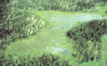
36 ;;;;;;;; yyyyyyyy CHANNEL FEN Channel Fen Channel fens occupy well-defined channels Scale Metres which at present do not contain an actively 0 50 Horizontal flowing stream. They are developed in ;;;;;;;; yyyyyyyy 0 2 Vertical abandoned glacial meltwater channels, glacial spillways, old river and stream channels or any other channel features which have either ;;;;;;;; yyyyyyyy lost their source of water and dried up or contain a Carex Salix very much smaller remnant stream continuing Gramineae to flow in the channel. These channels provide the opportunity for fen peat to accumulate. ;;;;;;;; yyyyyyyy SOIL TYPE Of Small streams may persist and flow slowly Om Oh across the fen. The depth of peat varies with Mineral deposits the geomorphology and hydrological setting ;;;;;;;; yyyyyyyy but may exceed 2 m. The surface of the peat is generally level or slightly concave in cross-section with some down gradient gentle slope. (a) well-defined, abandoned channel. (b) small stream flowing across the fen. ;y ;y ;y ;y;; ; y y ; ; y yyyy ;;;; yyyy ;;;; yyyy ;;;; yyy ;;; ; y y ; ;y ; y COLLAPSE SCAR FEN SOIL TYPE Collapse Scar Fen Collapse scar fens are small peatlands that Sphagnum peat Scale Mixed debris and fen peat originated through subsidence of a part of a Metres Of palsa fen. Melting of the permafrost in ;y Picea mariana 0 palsa 10 Horizontal fens causes the peatland surface to subside to ; y ;y Om 0 2 Vertical Oh Mineral deposits the same level or slightly below the water table Permafrost table Betula glandulosa around the palsa. The collapse scars are often yyy;;;;; yyyyy Salix sp. Larix circular or oval in outline, usually at the edge of Gramineae Carex a palsa fen. Dead trees leaning in all directions and other drowned vegetation are characteristic owing to the subsidence. The peat is ;;;;;;;; yyyyyyyy deep, usually in excess of 2 m, and consists of debris from the drowned vegetation and mesic peat of the fen. Collapse scar fens are wet. ;;;;;;;; yyyyyyyy (a) a more or less circular or oval outline at the edge of or adjacent to palsa fens. (b) dead trees often leaning in all directions with other drowned vegetation. 28
37 FEATHER FEN Feather fens are situated along long, narrow, low ridges of mineral soil mixed with contiguous and/or detached bog forms which occupy the slightly elevated sites. Feather fens are formed in narrow drainageways downslope from bogs. Water in feather fens is usually directed by streams running parallel to mineral soil ridges. Peat thicknesses are usually less than 2 m. (a) narrow and elongated fen mixed with bog which gives feathery surface patterns when viewed from the air. ;y ;y ;y Feather Fen Aerial view Creek, Stream, Swamp yy;y ;;yy yy;y;y;y ;;yy ; y yyyy ; y;;;; yyyy ; y ; y ; y ; y; y Feather Fen Bog Feather Fen Creek, Stream, Swamp ;y ;y ;;yy ;;yy Distance (m) Cross-section Larix Picea ;y ;y ;y ;;;;;; yyyyyy Shrub Bog Stream Peat Clay Stream Distance along transect (m) ;y ;y ;y HORIZONTAL FEN Horizontal fens occupy broad, ill-defined Horizontal Fen depressions. They occur on gentle slopes and are characterized by featureless surfaces. They are usually uniformly vegetated by graminoid, ;;;yyy ;;yy shrub or tree species. Some patterns, such as water tracks or somewhat drier treed islands may be present. Peat thickness varies from ;;;yyy 2 ;;yy to 3 m, depending on the topography of the underlying mineral substrate. Fibric peat is commonly found over mesic peat. ;;;yyy ;y ;;yy Soil Type (a) generally featureless, uniform Of peatland surface. Om ;y Scale (b) subtle gradation of fen into Oh Metres 0 50 Horizontal Mineral deposits 0 2 Vertical adjacent upland. 29
38 ;y yy ;; ;y yyy ;;; yyy ;;; yyy ;;; ;;;;yyyy yy ;; LOWLAND POLYGON FEN Lowland Polygon Fen Lowland polygon fens occur in lowlands in permafrost terrain where intense winter cold causes the formation of polygonal cracks. These fens have distinct polygonal patterning produced by displacement of soil and peat. Shrubs Sphagnum Graminoid vegetation characterizes wet low centres of the polygons. Peat-forming mosses occur along the edges of the polygons and in the trenches between polygons. Peat seldom exceeds 70 cm in the centre of the polygons. Scale (a) occurrence on ice wedges in polygon Metres pattern at the edge of peat polygons. (b) occurrence in centres of polygons which are low and wet, with minimal peat accumulation Horizontal 0 1 Vertical ;y ; ; y y SOIL TYPE Of Om Mineral deposits Ice Permafrost table Water Carex Gramineae ; y ; y PALSA FEN Scale Palsa Fen Metres Palsa fens are mounds of perennially frozen 0 10 Horizontal peat and mineral material, more or less ;;;;;;;; yyyyyyyy SOIL TYPE circular in outline. Most palsa fens are usually Mineral deposits 0 2 Vertical Fibric and mesic fen Dwarf Shrubs Permafrost table much smaller, but in extreme cases may reach Water heights of up to 5 m above the surrounding ter- ;;;;;;;; yyyyyyyy rain and diameters of up to 100 m. They are Gramineae composed of moderately to well decomposed sedge and brown moss peat of varying thicknesses. The peat cover may be thin (less ;;;;;;;; yyyyyyyy than 50 cm) and most of the palsa may be frozen mineral material and ice. The vegetation cover usually consists of sedges, mosses and shrubs. ;;;;;;;; yyyyyyyy Trees are usually absent from the palsa mounds. Unfrozen and usually wet fen may surround the palsa. The term palsa fen is used to refer to both palsa mounds proper and their immediate vicinity, and an entire low-lying fen area with scattered palsa mounds throughout it. Collapse scar fens may occur in association with palsa fens. (a) perennially frozen, treeless mounds of peat (palsas) in a fen. 30
39 RIPARIAN FEN Riparian fens develop adjacent to lakes, ponds and streams. The water table is influenced by the adjacent water bodies. Riparian fens may be subject to periodic flooding and display distinctive subforms based on their hydrological and peat characteristics. Three Riparian Fen subforms are recognized as follows: Floating Fen: These fens occur adjacent to ponds or lakes and are underlain by water or a mixed water and peat. The peat surface is generally less than 0.5 m above the lake level, and the rooting zone may be in contact with the lake water. The surface peat mat is usually formed by intertwining roots of graminoids and other kinds of vegetation. The underlying peat can be debris originating either from the fen or the lake, or both. The mats often extend from the shore and float on the water surface. In some fens, living Typha sp. mats can break free from their substratum and float on the water to form fen communities. Buoyancy of the floating mat is thought to be aided by methane trapped in the submerged peat in the mat. (a) fen mat adjacent to ponds or lakes. (b) soft, buoyant mat underlain by water or mixed water and peat. Floating Fen ;;yy ;y Carex Gramineae Sphagnum ;;;;;;; yyyyyyy ;;;;;;; yyyyyyy ;;;;;;; yyyyyyy ;;;;;;; yyyyyyy ;;;;;;; yyyyyyy yy;y Scale Metres 0 10 Horizontal 0 2 Vertical Shrubs SOIL TYPE Of Om Watery fen peat Water and peat Water Mineral deposits Shore Fen: These fens are situated adjacent to lakes or ponds where peat forms the shore. The surface peat does not float and is firmly yyy ;;; ;y yyyy ;;;; yyyyy ;;;;; ;y;y yyyy ;;;; yyy ;;; Shore Fen Carex Gramineae anchored. In some instances, peat accumulation can impede drainage which contributes to ;;;;;;;; yyyyyyyy Sphagnum a rise in water levels in the lake or pond and subsequent flooding of the fen around the shore. Shore fens usually contain moderately ;;;;;;;; yyyyyyyy to well decomposed sedge, bryophytic or aquatic vascular plant peat. Mosses or herbaceous plants occur closest to the water and trees. Shrubs, if present, are farther away ;;;;;;;; yyyyyyyy from the lake or pond edge. Peat depth usually SOIL TYPE Of exceeds 2 m. Om ;;;;;;;; yyyyyyyy ;;y Oh Scale (a) situated along the shores of a lake or Metres Limnic peat 0 10 Horizontal Water edge of a pond. Mineral deposits 0 2 Vertical (b) absence of susceptibility to flooding by lake or pond waters. 31
40 ;y ;;yy ;y ;y ;;yy ; y Stream Fen: These fens are located in the main Stream Fen channel or along the banks of permanent or semi-permanent streams. The generally yy ;; SOIL TYPE low Of Om gradient and slow water flow in the stream Carex Oh allows peat to form along the edges of the Gramineae Shrubs Alluviam Sphagnum stream. Peat, consisting chiefly of moderately ;;;;;;;; yyyyyyyy Water Mineral deposits to well decomposed graminoid remains, forms the banks of the stream. The peat may include inorganic layers, deposited during flood stages. The peat depth is variable, and it is often ;;;;;;;; yyyyyyyy in excess of 3 m. The water table of the fen is affected by the stream levels, both at normal and flood stages. ;;;;;;;; yyyyyyyy Scale Metres 0 10 Horizontal (a) located along the main channel of a slow 0 2 Vertical flowing stream. (b) peat forming much of the banks of the stream. ;;;yyyy y SLOPE FEN Slope fens develop on slopes in areas ;;; Slope Fen of high Scale SOIL TYPE PEAT COMPOSITION rainfall. Such slopes are also influenced by mineral-rich water from the surrounding mineral Metres Of Sphagnum Sedge 0 8 Horizontal soils. The surface of the fen is sloping, commonly 5 to 30 degrees. Pools are usually absent, but wet seepage tracks may be present. y Om Sphagnum Sedge 0 2 Vertical Oh Sedge ymineral deposits Sphagnum fuscum Calamgrostis sp. Potentilla palustris Campylium stellatum The peat is usually well to moderately decomposed and may reach depths of 1 to 2 m. Stream ;;;;;;; yyyyyyy Drosera intermedia (a) occurrence on sloping terrain. (b) peat ridges and pools are absent. ;;;;;;; yyyyyyy SNOWPATCH FEN Snowpatch Fen SOIL TYPE Snowpatch fens occur on slopes below perennial or late-melting snowbanks that accumu- Om - Oh ;;;;;;;; yyyyyyyy Ice and snow Mineral deposits late on the lee side of hills in the Arctic Permafrost table Water Wetland Region. The meltwater is not channelized on gentle slopes (less than three degrees) ;;;;;;;; and provides a steady source of water yyyyyyyy to the fen downslope from the snowpatch. The peat is usually shallow (less than 20 cm) and is composed of well to moderately decomposed ;;;;;;;; yyyyyyyy ;y Carex sp. sedge or cottongrass remains. Snowpatch fens Eriophoram sp. are underlain by heavily gleyed mineral soil ;y and permafrost which exists within 50 cm of Scale ;;;;;;;; yyyyyyyy Metres 0 50 Horizontal the surface. 0 2 Vertical (a) occurrence on slopes below perennial snowpatches in the Arctic Wetland Region. (b) thin peat is underlain by permafrost. ;;yy ; y ; y ;y ; y 32
41 SPRING FEN Spring fens are nourished by a continuous discharge of groundwater. The fen surface is marked by prominent drainage tracks, pools and occasionally, somewhat elevated peat islands. The amount of dissolved minerals is highly variable, depending upon the substrate through which it has passed. In some areas, the groundwater can be highly mineral-rich with calcium, which can form a precipitate in the pools to form marl. The peat thickness often exceeds 2 m and it may be intermixed with layers of aquatic peat or marl. (a) prominent drainage tracks originating from a water discharge area in a fen. (b) often contains highly mineral-rich groundwater. STRING FEN String fens develop on sloping terrain and are characterized by narrow, peaty ridges ( strings ) that enclose open water pools or depressions of open water ( flarks ) or wet fen surfaces. The strings develop at right angles to the direction of surface flow. These strings act as small dams which impede water flow. This gives rise to a downslope stepped pattern from one flark and string to the next ones. The configuration and spacing of the strings appear to relate to the slope gradient: the strings are more closely spaced on steep slopes, and farther apart and more poorly defined on gentler gradients. String fens display four distinctive subforms based on peat thickness, surface configuration and drainage conditions, as follows: ;; ;y ; y Atlantic Ribbed Fen: These fens occur on sloping terrain (5 to 30 degree slopes) in Scale Atlantic Ribbed Fen Metres 0 10 Horizontal Newfoundland, Labrador and the adjacent parts SOIL TYPE PEAT COMPOSITION 0 2 Vertical Of Sedge Sphagnum of Quebec. They are characterized by narrow Om Sedge ;;yy (usually less than 1 m wide) peat ridges that are Mineral deposits ;ybedrock Sphagnum fuscum oriented at right angles to the downslope. The Calamagrostis ridges are steep-sided and consist of relatively thin (less than 1.5 m deep) peat that acts as an ;y ;;;yyy ;; Sphagnum strictum Scirpus sp. ;;;; Drosera intermedia ;y Erratic Erratic effective barrier to water flow. Shallow pools (less than 1 m deep) are enclosed between the ;; ridges. The pools, oriented at right angles to the slope, comprise about 40 to 50% of the fen area. yyy;;;;; yyyyy (a) occurrence in cool, humid area of Newfoundland, Labrador and adjacent Quebec. (b) narrow, shallow peat ridges oriented at right angles to slope. (c) shallow pools enclosed by peat ridges. yy; y ; y;y ; y ;y ;y ; y ;;yy ;; ;; ; y ; y TYPEyyy Ladder Fen: These fens occur as a narrow strip Ladder Fen SOIL PEAT COMPOSITION along the edges of domed bogs. They contain Scale Of Sphagnum Sedge Metres Om Sphagnum Sedge a series of parallel, low peat ridges which 0 10 Horizontal Oh Sedge enclose narrow pools. The peat ridges are oriented at right angles to surface flow. Ladder fens act as drainageways for waters received 0 2 Vertical deposits ;ymineral Scirpus sp. from adjacent domed bogs and upland. The Calamgrostis Sphagnum tenellum Sphagnum fuscum fens are developed on moderate slopes (3 to ;;;;;;; yyyyyyy ;y;y;;; ;y;y;y;y Scirpus sp. Sphagnum papillusum 6 degrees). The peat is usually 1 to 2 m deep and consists mainly of moderately to well decomposed Sphagnum spp. and sedge remains. ;;;;;;; yyyyyyy (a) narrow (less than 20 m wide) strips of fen between domed bogs and upland. (b) narrow peat strings and pools oriented perpendicular to the direction of surface flow. yyyy ;;;; yy ;; ;yy ;; ;; ; 33
42 ;; yyy ;;; yyyy ;;;; yyyy ;;;; yyyy ;;;; yyy ;;; yy; Net Fen: These fens display a broad pattern of Net Fen SOIL TYPE low, interconnected peat ridges, often resembling a polygonal pattern, although permafrost Scale Of Metres 0 25 Horizontal Om 0 2 Vertical Oh is not present. The ridges enclose wet hollows Mineral deposits or shallow pools. The fen surface is almost flat. Carex ylarix The peat is usually deep (less than 3 m), consisting mainly of moderately decomposed peat. Gramineae Picea Sphagnum ;;;;;;;; yyyyyyyy (a) Net-like, irregular pattern of low peat ridges in non-permafrost terrain. yyyyyyyy ;;;;;;;; ;; ; y ;y ;;yy y ; ;;yy ;;yy ;;yy ;;;;;;;; yyyyyyyy Northern Ribbed Fen: These fens have subparallel, low peat ridges (strings) which enclose Of Northern Ribbed Fen SOIL TYPE Scale elongated wet hollows or shallow pools. The Om Metres Oh 0 25 Horizontal ridges and hollows are oriented perpendicular Mineral deposits 0 2 Vertical to the direction of surface flow. The thickness ylarix Carex Picea of peat generally exceeds 2 m, and it is composed of moderately decomposed sedge and Gramineae ;;;;;;;; yyyyyyyy Sphagnum moss remains. Trees often grow on the ridges. (a) subparallel low peat ridges which enclose ;;;;;;;; yyyyyyyy hollows oriented perpendicular to the direction of surface flow. (b) peat usually over 2 m deep. yyyyyyyy ;;;;;;;; (c) occurrence in all parts of the Boreal Wetland Region. yy; 34
43 Table 4: Classification Key to Fen Wetland Forms and Subforms 1. Surface sloping 2. Surface with a pattern of peat ridges and depression String Fen 3. Subparallel pattern of peat ridges and depressions 4. Occurs in valleys, often extensive 5. Northern regions; lowland drainage; peat usually more than 2 m thick Northern Ribbed Fen 5. Atlantic regions; mainly in upland drainage, peat usually less than 1 m thick Atlantic Ribbed Fen 4. Narrow step-like pattern; along raised bog banks Ladder Fen 3. Reticulate pattern ridges and depressions Net Fen 2. Without pronounced surface pattern 6. In permafrost terrain 7. Occurring as mounds in patterned or non-patterned fen Palsa Fen 7. Surface even, without mounds; associated with late-melting or perennial snowbanks Snowpatch Fen 6. In non-permafrost terrain 8. Water originating from groundwater discharge Spring Fen 8. Water originating as overland flow or as subsurface seepage through the peat 9. Surface with parallel drainageways Feather Fen 9. Surface smooth or with irregularly spaced tracts Slope Fen 1. Surface flat or depressional 10. In permafrost terrain, surface with network of polygonal fissures Lowland Polygon Fen 10. In non-permafrost terrain Riparian Fen 11. Located adjacent to water bodies 12. Peat mat floating on water or watery peat Floating Fen 12. Peat not floating 13. Located in main channel or along banks of continuously flowing or semi-permanent streams Stream Fen 13. Located along shores of semi-permanent or permanent lakes Shore Fen 11. Not adjacent to water bodies 14. Surface with circular pattern of depressed thaw hollows filled with watery peat Collapse Scar Fen 15. Basin part of regional drainage system 16. Occupying broad depressions or plains Horizontal Fen 16. Occupying well-defined, often incised relict channels Channel Fen 15. Basin not part of regional drainage system Basin Fen 35

44 Deciduous Basin Swamp in southern Ontario with Caltha palustris (B.G. Warner, Wetlands Research Centre)
45 Swamp Wetland Class The term swamp has been used in Canada to refer to forested or wooded wetlands and peatlands. The treed swamps have also been called swamp forest or forested wetland. A swamp can be defined as a treed or tall shrub (also called thicket) dominated wetland that is influenced by minerotrophic groundwater, either on mineral or organic soils. The essential features of the swamp class are the dominance of tall woody vegetation, generally over 30% cover, and the wood-rich peat laid down by this vegetation. The water table is below the major portion of the ground surface, and the dominant ground surface is at the hummock ground surface, that is, 20 cm or more above the average summer groundwater level. It is the aerated (or partly aerated) zone of substrates above the water that is available for root growth of trees and/or tall shrubs. Swamps are not as wet as marshes, fens and the open bogs, but they are comparable to the treed bogs. The drier treed swamps grade into upland forest on mineral soil, and the wettest treed swamps grade into treed fen, which is wetter with less tree canopy cover. The tall shrub swamps grade into treed fen, which is wetter with less tree canopy cover. The tall shrub swamps grade into wetter marshes. Swamps occur on mineral soils as well as on peat. The texture of underlying mineral soils is variable, ranging from clays to sands, and they frequently are Gleysols. On sands, iron-rich ortsteins or fragipans are often present, acting as impermeable layers which impede water drainage. Swamps on mineral soils tend to accumulate peat by the paludification process. When organic soils develop, they are Mesisols or Humisols that are rich in woody peat, at least in the surface layers. Swamps on peat have developed by a basin-filling process or by paludification of previously drier mineral soils. In the basin-filling process, the previous ecosystem was a marsh or fen, whereas in paludification the swamp has developed over an older, dry upland forest on mineral soil. The nutrient regime in swamps is highly variable ranging from base-rich conditions with ph above 7.0, to base-poor conditions where ph can be in the range of 4.5 or lower. One may recognize swamp forms based on the base-rich/ph gradient, i.e. calcareous rich (eutrophic), intermediate (mesotrophic), and poor (oligotrophic). Poor minerotrophic swamps may be transitional to treed ombrotrophic bog. There are three general physiognomic types of swamps shrub (thicket) swamps, coniferous swamps, and hardwood (deciduous) swamps. One may also recognize a mixed swamp with conifers and deciduous trees. The understory is shaded and contains forest species that can tolerate shade. Generally, deciduous and shrub swamps occur in somewhat richer conditions, the deciduous swamp being in dry locations, and the shrub swamp in somewhat wetter locations. Coniferous swamps occur across a wider range of trophic levels from rich to poor. The primary characteristics of swamps are: (1) peatland and mineral wetland; (2) water table at or below the surface; (3) minerogenous; (4) highly decomposed woody peat and organic material; and (5) coniferous or deciduous trees, or tall shrub vegetation cover. Swamp Wetland Forms and Subforms The main criteria used to characterize the forms of swamps are landform, hydrological system and physiographic position relative to mineral soil uplands, water bodies and other classes of wetlands. Swamps are found in association with tidal systems, inland salt lakes, basins and depressions in glaciated landscapes, riparian systems (rivers, streams and flowage lakes), unconfined broad slopes, confined drainageways, and on raised, wet mineral rises and raised peat plateaus. Swamps in northern boreal areas may be associated with discontinuous or continuous permafrost, but no attempt is made to recognize these forms specifically in this classification system. A classification key to the swamp wetland forms and subforms is presented in Table 5. 37
46 DISCHARGE SWAMP Discharge swamps are topographically flat. They are developed on sites of groundwater discharge located adjacent and above the swamp. Discharge Swamps have two subforms: Seepage Swamp: These swamps develop around and along the outflow of groundwater seepage. There are no distinct springs on the surface. (a) situated in groundwater discharge zones with no obvious springs present. Spring Swamp: These swamps are similar to seepage swamps but are developed on or along the outflow of springs. The springs may or may not supply small streams flowing through them. (a) situated in groundwater discharge zones with obvious springs. FLAT SWAMP Flat swamps develop in topographically defined basins, kettle holes or bedrock where the water is derived by surface runoff, groundwater or precipitation and occasionally by small inflowing surface streams. Flat swamps may also occupy poorly defined basins such as those in broad, shallow depressions in glacial lakebeds and outwash plains. Peat depths may be 0.5 to more than 2 m at the centre. Three Flat Swamp subforms are recognized: Basin Swamp: These swamps are topographically defined in glacial features on ablation till plains. The edges are well-defined by the sides of the basin and the surrounding mineral soil uplands. (a) occurrence in well-defined basins in glacial deposits or bedrock. Swale Swamp: These swamps occur close to lakes or open water bodies, as linear or crescentic-shaped depressions between abandoned beach ridges and in wet depressions in sand dunes. (a) occurrence in close proximity to lakes or large open water bodies. (b) associated with dunes and abandoned beach ridges. (c) linear and narrow in outline. Unconfined Flat Swamp: These swamps are not topographically defined, often in glacial lakebeds or areas of glacial outwash. These swamps lack obvious edges and well-defined banks. They commonly occur as a broad swamp in other kinds of wetlands. (a) broad swamp among other kinds of wetlands with poorly defined edges. (b) common on old glacial lakebeds and spillways. INLAND SALT SWAMP Inland salt swamps develop in or on the margins of inland salt (sodium, magnesium, calcium enriched) lakes, ponds or wetlands. These are often thickets that can tolerate high concentrations of salt. (a) located near inland, saline lakes and marshes. MINERAL-RISE SWAMP Mineral-rise swamps develop on raised mounds or ridges of mineral deposits or bedrock. There is evidence of the influence of underlying mineral soil. These swamps are surrounded by wet sites that maintain swamp water levels or periodic flooding. Four Mineral-rise Swamp subforms are recognized: Beach Ridge Swamp: These swamps can be surrounded by mineral terrain, wetland or other kinds of wetland but are confined to beach ridges. (a) occurrence on beach ridges. 38
47 Island Swamp: These swamps occur on an island, bar or point in a riparian condition. (a) occurrence within a riparian zone on an island, bar or point. Levee Swamp: These swamps are similar to island swamps but occur on levees. (a) occurrence in a riparian zone on levees. Mound Swamp: These swamps occur on mineral sediments or bedrock and are surrounded by peatland. (a) occurrence within a peatland on a bedrock or mineral sediment. RAISED PEATLAND SWAMP Raised peatland swamps occur as raised plateaus, similar to and often transitional to domed bogs, but there is minerotrophic groundwater influence. These are similar to mineral-rise swamps but are elevated by peat and are situated entirely in peatland terrain. (a) situated on raised peat plateaus rather than on mineral deposits or bedrock. RIPARIAN SWAMP Riparian swamps are located along rivers, streams and lakes, and are directly influenced by the water in the river, stream or lake next to them. They are subjected to dramatic water level fluctuations, seasonal flooding and influx of sediment and mineral enrichment during high water periods. Peat accumulation is usually shallow, often less than 40 cm, but depths of more than 1 m can exist. The other organic sediments often have mineral content, more than deposits in peatlands owing to frequent flooding of waters from adjacent rivers, streams and lakes. Four Riparian Swamp subforms are recognized: Channel Swamp: These swamps occur in abandoned river or stream channels, or oxbows, often associated in meandering river valleys, braided streams, or alluvial plains. They may be seasonally flooded. Peat development is usually quite shallow. (a) situated in abandoned river and stream channels. (b) not in direct contact with stream and river waters. Floodplain Swamp: These swamps occur in the floodplain valley of rivers and streams or behind levees. These swamps are not in direct contact with the river or stream and are flooded when river and stream waters overflow their banks and cover the floodplain, often during the spring melt period. Peat depths are shallow. (a) situated in river and stream floodplains. (b) not in direct contact with river and stream water. (c) subject to flooding when river and stream waters overflow their banks. Lacustrine Swamp: These swamps occur along the shores of permanent ponds or lakes. The high water table is maintained by the lake water level which may flood the lacustrine swamp during high water periods. Marsh or fen may occur between lacustrine swamp and the open water. (a) situated in close proximity to or immediately adjacent to open water bodies. (b) subject to flooding when water table is high in the open waterbody. Riverine Swamp: These swamps occur along the banks of rivers and permanent and intermittent streams. The water table in riverine swamps is maintained by the level of the water in the adjacent river or stream. (a) situated immediately adjacent to rivers and streams. (b) subject to flooding when stream or river waters are high. 39
48 SLOPE SWAMP Slope swamps have surfaces that slope downward with the lowest end positioned lower than the upslope side. They occupy glacial lakebeds and outwash areas, or can be associated with other kinds of wetland. They may occur in sloping drainageways, on mineral or peaty soils. Channels may be absent, but small channels with intermittent flow or small, partially buried channels may be present. Four Slope Swamp subforms are recognized: Drainageway Swamp: These swamps occur in a confined drainageway or water track, either in mineral or peatland terrain. Water movement is as unilateral sheet flow. (a) sloping surface. (b) situated in a confined drainageway or water track. Lagg Swamp: These swamps occur in the zone between upland mineral terrain and a peatland (swamp, fen or bog). The lagg swamp is a wetland distinctly enriched by runoff from the upland. Surface water movement is parallel to the upland. (a) sloping surface. (b) situated between mineral terrain and peatland. (c) mineral enriched from adjacent mineral soils. Peat Margin Swamp: These swamps have sloping topography and are situated between peatland and upland mineral terrain. Hydrology is such that paludification allows the swamp to spread outwards into adjacent upland. They can also be a relatively less dynamic zone between upland and peatland. (a) sloping surface. (b) position between peatland and mineral terrain or totally within peatland terrain. Unconfined Slope Swamp: These swamps occur as a broad expanse of sloping wetland on glacial lakebeds and outwash areas in peatland terrain. They may also occur at the margins of extensive flat swamps. (a) sloping surface. (b) broad, expansive area with poorly defined edges. TIDAL SWAMP Tidal swamps develop in the zone of influence of tides, at the highest reach of tides and wave influence during storms. These are often thickets that can tolerate a short period of flooding. Some forested swamps exist where there is minor influence of high tides, but not long enough to kill the trees. An example is a tidal swamp forest on the levees of rivers where they join marine waters. Two Tidal Swamp subforms are recognized: Tidal Freshwater Swamp: These swamps occur adjacent to tidal systems. They are influenced mostly by freshwater and by brackish or saline water only during extreme high tides or storm surges. However, they are usually situated too high in the supratidal zone to be influenced by saline or brackish water. (a) situated near estuaries and high in supratidal zones on the sea coast. (b) primarily freshwater and rarely brackish water. Tidal Saltwater Swamp: These swamps occur in the intertidal and supratidal zones. The water is saline or brackish. (a) situated in supratidal zone on sea coast. (b) brackish and freshwater. 40
")
49 Mixed Deciduous and Coniferous Swamp in central Ontario (B.G. Warner, Wetlands Research Centre)
50 Table 5: Classification Key to Swamp Wetland Forms and Subforms 1. Influenced by tidal water Tidal Swamp 2. On or beside marine terraces, beach ridges, levees, islands, points, inundated Tidal Saltwater only at highest tides and/or storm surges by saltwater; coastal and estuarine Swamp 2. Same as above, inundated only at highest tides and/or Tidal Freshwater storm surges by freshwater Swamp 1. Not influenced by tidal water 3. Margins of inland saline lakes and marshes in arid zones, influenced Inland Salt Swamp by high concentrations of sodium, magnesium, calcium or sulphate 3. Freshwater, includes calcium-rich high ph to calcium-poor low ph waters, and permanent and seasonally flooded 4. Topographically flat or slightly concave, water flowing Flat Swamp into the middle of the basin, in topographically defined basins, kettle holes, swales and extensive peatlands 5. Confined depressions with distinct slopes to the side of the basin 6. Formed on glacial deposits such as kettle holes, eskers, moraines Basin Swamp 6. Orientated in linear or crescentic patterns, the hollows between Swale Swamp beach ridges, or interdunal depressions 5. Unconfined basins, extensive and poorly defined depressions, Unconfined Flat Swamp occurring on flat glacial lakebeds, outwash plains 4. In or along channelized systems, lakes, rivers, streams, depressions and sloping wetlands 7. Along lakes, rivers and streams, with high water level Riparian Swamp fluctuations and periodic flooding 8. Along lakes as zones usually landward from marsh or fen Lacustrine Swamp 8. Along rivers, streams and abandoned stream or river channels 9. Adjacent to rivers or streams Riverine Swamp 9. Not immediately adjacent to flowing water, in cutoff channels, or on floodplain behind levees 10. In a floodplain Floodplain Swamp 10. In or along a cutoff river channel, including oxbows Channel Swamp 42
51 Table 5: Classification Key to Swamp Wetland Forms and Subforms cont d 7. Topographically sloping, with or without channels, or only small channels with intermittent water flow 11. With sloping topography, in unconfined expanses, Slope Swamp confined drainageways or water tracks 12. Non-channelized, topographically sloping, on glacial lakebeds, outwash plains or unconfined peatlands 13. In peatland terrain Unconfined Slope Swamp 13. Occurring in the zone between peat and mineral soil Peat Margin Swamp 13. At margins of peatlands Lagg Swamp 12. Sloping swamps in water tracks or drainageways with distinct peat banks, sometimes with small, intermittent channels flowing on them 14. Occurring in water tracks or drainageways Drainageway Swamp 14. Occurring in wet zones between upland and peatland Lagg Swamp 15. Groundwater discharge sites Discharge Swamp 16. Springs with obvious upwelling water, Spring Swamp small streams 16. Seepage sites, no obvious upwelling water Seepage Swamp 15. Not with groundwater discharge, swamps on raised ridges or mounds, mineral or peat 17. Swamps on raised mineral mounds in fens, river islands and bars, beach ridges, Mineral-rise Swamp and levees surrounded by wetter ecosystems, influenced by periodic flooding or high levels of mineral groundwater 18. Mineral rises associated with riparian systems 19. On islands or bars Island Swamp 19. On levees Levee Swamp 18. Associated with lakes or peatlands 20. On beach ridges, surrounded by wetter land Beach Ridge Swamp 20. On mineral deposits or bedrock surrounded by wetter wetland Mound Swamp 17. Swamp peat plateaus, similar to and often transitional to raised bog; Raised Peatland Swamp influenced by mineral groundwater 43

52 Riparian Marsh on St. Lawrence River near Lachine, Quebec (M. Melancon, Environment Canada)
53 Marsh Wetland Class A marsh is a wetland that has shallow water, and has levels that usually fluctuate daily, seasonally or annually due to tides, flooding, evapotranspiration, groundwater recharge, or seepage losses. Marshes may experience water level drawdowns which will result in portions drying up and exposing the sediments. Marshes receive their water from the surrounding catchment as surface runoff, stream inflow, precipitation, storm surges, groundwater discharge, longshore currents and tidal action. Marshes dependent upon surface runoff usually retain less permanent water than sites supplied by groundwater. The water table usually remains at or below the soil surface, but soil water remains within the rooting zone for most of the growing season, except in years of extreme drought. In semi-arid regions, some basin marshes may remain dry for several consecutive years, and consequently may assume some characteristics of terrestrial ecosystems until water levels are restored by above-average precipitation and runoff. When wet, these marshes display all the characteristics and processes common to typical seasonal or semi-permanent marshes. The hydrology of marshes may vary much more dramatically seasonally from being constantly saturated or semi-permanently flooded than the other classes of wetlands. Marshes, therefore, respond to rapid fluctuations in surface water, going through cycles of drawdown and regeneration, degeneration and open water stages over the course of a few years. A marsh is a minerotrophic and usually eutrophic wetland. Nutrients are derived from the substrate through periodic aeration. High nutrient levels give rise to the characteristic high productivity of vascular plants and high decomposition rates of the plant material at the end of the growing season. Such high rates of decomposition give rise to marshes producing significant quantities of gases such as methane and carbon dioxide. Freshwater marshes are usually circumneutral to highly alkaline owing to the presence of dissolved minerals such as calcium, potassium carbonate, or potassium bicarbonate. The water in saline marshes is high in dissolved salts because water losses through evaporation concentrate sulphates and chlorides of sodium and magnesium. In highly saline marshes, vegetation development is severely hampered because salt concentrations are so high as to become toxic to plants. Soils and substrates encountered in marsh wetlands typically range from mineral soils such as Humic and Rego Gleysols to organic soils such as Humisols and Mesisols. Normally, marsh sediment is a mixture of unconsolidated organic and inorganic material. Clumps, hummocks, or tussocks of live and dead herbaceous vegetation may exist in standing water. Those marshes that are seasonally dry or exposed to high energy currents or tides usually accumulate little organic matter, in contrast to hydrologically more stable and permanently saturated marshes. In the latter case, such as in lakeshore or delta marshes, Humisols develop; this organic material can accumulate but seldom is more than 40 to 50 cm deep. Under persistent conditions of stable water, floating mats of vegetation form from sedges and aquatic mosses. This is characteristic of marsh stages transitional to rich fens. Marsh vegetation predominantly comprises emergent aquatic macrophytes, chiefly graminoids such as rushes, reeds, grasses and sedges, and shrubs and other herbaceous species such as broad-leaved emergent macrophytes, floating-leaved and submergent species, and non-vascular plants such as brown mosses, liverworts, and macroscopic algae. The marsh definition embraces the terms reed swamp (reeds and tall grasses) and marsh (grass-sedge-rush community); and is equivalent to the marsh and sedge meadow communities. Vegetation is usually arranged in distinct zones of parallel or concentric patterns in response to gradients of water depths, frequency of drawdowns, water chemistry or disturbance. Three basic marsh zones are usually attributed to water duration and depth: (a) transitional open water, (b) emergent deep marsh, and (c) shallow marsh (Millar 1976). The typical sequence, which progresses from open pools with aquatic plants to emergent reeds, through sedges and reed grasses, then low rushes, sedges and herb meadows, to tall shrubs and trees at the extreme edge of the marsh, follows a decreasing moisture gradient. Saline or brackish marshes also have gradients but with fewer zones that include, barren salt flats in the centre of the marsh, rushes, and then halophytic herbs and grasses at the outer edge. Seasonal drawdowns may expose mudflats which are revegetated by pioneering herb and grass species. Plant communities of seasonal marshes are dynamic. They shift spatially with water levels, and change in composition over a short time, whereas communities of semi-permanent marshes usually are more stable, represented by stands of reeds which may persist for many years in the absence of severe drought. Marshes occur in many geomorphological settings which include low-lying areas adjacent to rivers, lakes, the sea, and any other position on the land surface where groundwater may discharge. In northern regions, marshes are common in nutrient-rich sites associated with rivers either in the floodplains or at their mouth on alluvial fans and deltas. Along seacoasts, tidal marshes are located in estuaries or lower stream reaches, and behind baymouth bars or other sites protected from high energy waves. 45
54 The primary characteristics of marshes are: (1) mineral wetlands; (2) shallow surface water which fluctuates dramatically; (3) minerogenous; (4) little accumulation of organic material and peat of aquatic plants; and (5) emergent aquatic macrophytes largely rushes, reeds, grasses, and sedges and some floating aquatic macrophytes. Marsh Wetland Forms and Subforms Marsh wetland forms are differentiated on the basis of the source of water and basin topography. A classification key to the marsh wetland forms and subforms is presented in Table 6. BASIN MARSH Basin marshes are situated in well-defined basins and depressions in inland regions outside the influence of sea waters and sea spray. They receive waters from groundwater discharge, surface runoff and stream and river inflow. Basin marsh subforms could be further subdivided into freshwater and saline subforms. Three subforms of Basin Marsh are recognized: Discharge Basin Marsh: These marshes occupy Discharge Basin Marsh flat areas, depressions, basins, kettles or sinkholes below the groundwater table. The basins Marsh/ are usually much larger and deeper than isolated basin marshes. The marsh receives most of Shallow Water its water as groundwater discharge that is cold Groundwater and usually high in dissolved minerals. Discharge Mineral deposits Groundwater discharge operates for much ofyysediments the year, including the winter, except for some discharge basin marshes in the Continental Prairie Wetland Region. Waters can be fresh, but are often brackish and saline. In the Continental Prairie Wetland Region, discharge basin marshes may be characterized by evaporite deposits of salts and other minerals around them which preclude vegetation growth. It is possible to have freshwater or saline discharge basin marshes. (a) deep basins, depressions, or sinkholes that lie below the groundwater table. (b) receives most of its water as groundwater discharge. (c) waters may be saline or fresh, but are usually high in dissolved solids. (d) located in topographically low areas. ;y Isolated Basin Marsh: These marshes occupy Isolated Basin Marsh topographically-defined basins formed by glacial erosional and depositional processes, Evaporation Surface slumping, solution or ablation of unconsolidated deposits and bedrock. There are no surface Meadow Flats Runoff Alkaline Salt Saline Barren Salt inlets or outlets. The marsh receives water from ;;;;;; yyyyyy Deposits Halophytes Intermittent waters rain, snowmelt, surface runoff, and groundwater discharge. The length of time that the Sediments Groundwater Mineral deposits Discharge marsh retains water is dependent upon water;; yy ;;;;;; yyyyyy exchanges with the groundwater table, the permeability of geological substrates, and water losses by evaporation. Water may be saline with saline rings around the periphery in arid regions and fresh in non-arid regions. It is possible to have freshwater or saline isolated basin marshes. (a) situated in closed, topographically-defined shallow basins and depressions. (b) lack of surface inlets and outlets. (c) waters may be saline or fresh. ;;;;;;;;;;;;;;;;;; yyyyyyyyyyyyyyyyyy ;;;;;;;;;;;;;;;;;; yyyyyyyyyyyyyyyyyy ;;;;;;;;;;;;;;;;;; yyyyyyyyyyyyyyyyyy ;;;;;;;;;;;;;;;;;; yyyyyyyyyyyyyyyyyy ;;;;;;;;;;;;;;;;;; yyyyyyyyyyyyyyyyyy ;y Runoff ;;;;;;;;;;;;;;;; yyyyyyyyyyyyyyyy ;;;;;;;;;;;;;;;; yyyyyyyyyyyyyyyy ;;;;;;;;;;;;;;;; yyyyyyyyyyyyyyyy ;;;;;;;;;;;;;;;; yyyyyyyyyyyyyyyy ; ; y y;; ;y 46
55 Linked Basin Marsh: These marshes occupy defined depressions that have channelized inlets and outlets operating during periods of abundant surface flow. The linked basin marsh is subject to intermittent surface and groundwater inflow, primarily from the local watershed, but may receive regional inflow from beyond the local catchment. This marsh subform usually occupies intermediate topographic positions and intermittently contains water. (a) situated in well-defined shallow basins and depressions that have surface inlets and outlets. (b) the amount of water in the marsh is related to periods of abundant surface flow. ESTUARINE MARSH Estuarine marshes are confined to intertidal and supratidal zones of estuaries. Water levels are subjected to tidal changes but water levels do not change as greatly as in other tidal marshes. There is a major input of freshwater in these marshes which makes estuarine marsh waters brackish to fresh. Vegetation develops in zones in response to variations in slope, water depth and salinity gradient. Water is brackish or fresh. Four subforms of Estuarine Marsh are recognized: Estuarine Bay Marsh: These marshes develop along the fringes of tidal flats, bars or tidal channels located within tidal inlets or bays which receive water from rivers and streams. Situated at or below low tide levels, the estuarine bay marsh is subjected to regular inundation by tidal saltwater and freshwater. (a) intertidal or supratidal zone of estuaries. (b) situated in embayments or inlets of estuaries. Estuarine Delta Marsh: These marshes develop on deltaic areas at the mouths of rivers and streams that flow into estuaries. They occur on tidal flats, levees, bars, lagoons, channels and basins which are elevated above mean low tide levels. Water levels are subjected to periodic flooding by saline and brackish water during high tides that are flushed by inflowing freshwater during low tides. (a) intertidal or supratidal zone of estuaries. (b) situated on deltaic river and stream mouths. Estuarine Bay Marsh Riverine flow Marsh ;;;;;; yyyyyy Tidal bore High Tide Freshwater flow Low Tide ;;;;;;;;;;;;;;;;; yyyyyyyyyyyyyyyyy ;;;;;;;;;;;;;;;;; yyyyyyyyyyyyyyyyy Sediments Mineral deposits ;;;;;;;;;;;;;;;;; yyyyyyyyyyyyyyyyy y;; ;;; yy ; y ; y y;; yy ;y Estuarine Delta Marsh y;; ; ; y ; y Riverine flow Levee Levee Interfluvial basin Channel Channel Levee ;;yy Marsh Beach High Tide yyyy;;;;;;;;;;;;; yyyyyyyyyyyyy Low Tide Seepage Sediments ;;;;;;;;;;;;; yyyyyyyyyyyyy Mineral deposits yy ;;;;;;;;;;;;; yyyyyyyyyyyyy Estuarine Lagoon Marsh: These marshes occur in embayments, lagoons and open basins in the supratidal and intertidal zone of estuaries. They are susceptible to extreme water level changes. Freshwater input is significant. (a) intertidal and supratidal zone of estuaries. (b) developed in lagoons, inlets, basins that are connected to the main estuary. Estuarine Shore Marsh: These marshes occur as linear bands along the shore of estuaries removed from the main outer coast. Freshwater input is significant. (a) intertidal and supratidal zone of estuaries. (b) occur as linear features along the coast of estuaries. 47
56 HUMMOCK MARSH Hummock marshes occur on heights of land in zones of groundwater upwelling and are perched above the groundwater table. They may be located on slopes or in depressions. Hummock marshes may form by the accretion of mineral or organic material built up by discharging mineral-rich groundwater. The surface of vegetation communities in hummock marshes is usually saturated and quaking. (a) shallow depressions built up by accretion of mineral and organic material. (b) situated in groundwater discharge areas above the groundwater table. LACUSTRINE MARSH Lacustrine marshes occur along the shores of permanent inland, open water bodies and lakes. Water sources are a combination of input from adjacent lakes, rivers and streams flowing into the lake, surface runoff from the adjacent catchment, and groundwater discharge. Such marshes have freshwater. Three subforms of Lacustrine Marsh are recognized: Lacustrine Bay Marsh: These marshes occupy Lacustrine Bay Marsh gently sloping offshore zones, recession flats, or shoals of shallow bays of more permanent Runoff lakes, merging with deep water (more than 2 m). Lacustrine bay marshes develop in lakes subject to sediment infilling and periodic drawdowns. Water levels are not as stable in lacustrine bay marshes as they are in lacustrine Mineral deposits yysediments shore marshes. (a) situated in offshore zones and shallow bays of permanent lakes. (b) water levels are susceptible to dramatic changes and drawdowns. Lacustrine Lagoon Marsh: These marshes are situated in semi-closed basins behind barrier beaches or bars adjacent to lake; protected from direct wave action; subject to increases in lake level. Characteristics features are: (a) in basins behind barrier beaches and bars adjacent to lakes. Lacustrine Lagoon Marsh Runoff ; ; y y;; Seepage Mineral deposits yysediments Lacustrine Shore Marsh: These marshes develop on recent lacustrine sediments, along the Lacustrine Shore Marsh Runoff shoreline, and between high and low water positions, on permanent lakes and merging with deep water. Lacustrine shore marshes collect surface runoff and are subject to periodic Seepage flooding by wave action and rises in lake levels. Inflow They are associated with recession flats, Mineral deposits yysediments lagoons, swales and beach ridges. (a) situated in the nearshore zone of permanent, freshwater lakes. (b) water levels relatively stable. yy ;; yyy ;;; yy ;;; yyy y; ; y yy ;; y; Beach Marsh Shallow Water ;;;;;;;;;;; yyyyyyyyyyy Seepage ;;;;;;;;;;; yyyyyyyyyyy Seepage Beach ridge Marsh Back flooding y;; ; ; y ;;yy ;;yy ; y y;; ; ; y Flood level Low level ;;;;;;;;;;;;;;;; yyyyyyyyyyyyyyyy Overflow Marsh ;;;;;;;;;;;;;;;; yyyyyyyyyyyyyyyy ;;;;;;;;;;;;;;;; yyyyyyyyyyyyyyyy Seepage Outflow ;;;;;;;;;;;;;;;; yyyyyyyyyyyyyyyy Deep Flood level Low level Lake Lake 48
57 RIPARIAN MARSH Riparian marshes occupy riparian zones of streams and rivers. They may receive waters from precipitation, groundwater discharge, and surface runoff, but are most closely linked to water quality and quantity in an adjacent stream or river. Four subforms of Riparian Marsh are recognized: Riparian Delta Marsh: These marshes develop Riparian Delta Marsh on active or abandoned glacial deltas which still have a stream or river running over them. The Marsh Levee Levee Riverine Flow marsh is flooded by overbank flows, runoff or seiches from adjacent lakes. The marsh is associated with interfluvial basins, levee backslopes, shorelines, distributory channels or lagoons. Sediments Mineral deposits (a) situated on deltaic plains. ;y (b) flooded by stream waters which overflow their banks, surface runoff or lake water. Riparian Floodplain Marsh: These marshes Riparian Floodplain Marsh develop on aggraded alluvial plains and terraces Runoff bordering on but not draining into lower, perennial streams. Water is derived from surface Levee runoff and during periodic overbank floods. Terrace Marsh Oxbow Water level in the marsh is maintained by a high water table. The riparian floodplain marsh is usually Sediments Seepage associated with swales, oxbows, levees and Mineral deposits meander scars. ;y (a) situated on aggraded alluvial plains and terraces usually in swales, oxbows and meander scars. Riparian Meltwater Channel Marsh: These marshes develop in abandoned channels or in underfit stream channels situated in broad spillway valleys and postglacial alluvial and outwash plains where water flow is ephemeral or discontinuous. The primary water source in the marsh is from surface flow and groundwater inflow. (a) situated in broad spillway valleys, and alluvial and outwash plains. ;;;;;;;;;;;;;;; yyyyyyyyyyyyyyy Back flooding Flood Level Seepage ;;;;;;;;;;;;;;; yyyyyyyyyyyyyyy Channel Beach Lake Low Level ;;;;;;;;;;;;;;; yyyyyyyyyyyyyyy ;;;;;;;;;;;;;;; yyyyyyyyyyyyyyy Riparian Stream Marsh: These marshes are Riparian Stream Marsh located on embankments, channels, islands or streambed materials on first, second or third Runoff order water courses with continuous or intermittent flow. Stream marshes are usually found on Marsh recent alluvial sediments deposited in protected Flow Seepage areas not influenced by strong water currents. Sediments This marsh subform incorporates dammed Mineral deposits flowages and throughflow ponds, but excludes ;y floodplains. (a) situated on embankments, channels, islands and other riparian zones of streams and rivers. y ; yyy ;;; ;y yyyy ;;;; yyyy ;;;; yyy ;;; ;;;;;;;;;;;;;; yyyyyyyyyyyyyy Flood Level ;;;;;;;;;;;;;; yyyyyyyyyyyyyy Low Level River ;;;;;;;;;;;;;; yyyyyyyyyyyyyy Channel ;;;;;;;;;;;;;; yyyyyyyyyyyyyy Riparian Meltwater Channel Marsh ;y Runoff Sediments Mineral deposits yy;; ;y ;y ; y Runoff ;;;;;;;;;;;; yyyyyyyyyyyy Seepage Glacial-fluvial ;;;;;;;;;;;; yyyyyyyyyyyy Marsh Channel ;;;;;;;;;;;; yyyyyyyyyyyy Intermittent Ground Water Flow ;;;;;;;;;;;; yyyyyyyyyyyy ;;;;;;;;;;;;; yyyyyyyyyyyyy Point ;;;;;;;;;;;;; yyyyyyyyyyyyy Bar ;;;;;;;;;;;;; yyyyyyyyyyyyy ;;;;;;;;;;;;; yyyyyyyyyyyyy 49
58 SLOPE MARSH Slope Marsh Slope marshes develop on lower elevation slopes where water-bearing strata and impermeable layers contact the ground surface. Slope marshes occupy wet seepage areas where groundwater discharges. The slope marsh is characterized by hummocky microrelief, soggy, saturated ground and flushes. Sediments (a) occupying seepage slopes where groundwater discharges. SPRING MARSH Spring marshes occupy first order water courses or rills that drain point source discharge of springs or upwelling groundwater. Drainageway tracks, pools or small eroded channels are characteristic, usually arranged in radiating or dendritic patterns. (a) situated in groundwater discharge zones. (b) drainage patterns and pools. TIDAL MARSH Tidal marshes develop along beaches, bars, reefs or islands of sea coasts, protected from wave action and storm surges. Development is on coarse to fine-grained sediments in intertidal zones and some supratidal zones influenced by salt spray. Tidal marsh is flooded regularly by tidal saltwater with no major influence from freshwater. Water is saline or brackish. Vegetation communities development is in response to duration of exposure, slope gradients, distribution of tidal channels and basins, and salinity. Four Tidal Marsh subforms are recognized: Tidal Basin Marsh: These marshes are situated within the supratidal zone in basins that do not drain during low tide. Water is brackish. (a) in supratidal zones on sea coast. (b) situated in basins that do not drain during low tide. (c) brackish water. Surface ;;;;;;;;;;;;;;;;; yyyyyyyyyyyyyyyyy Runoff ;;;;;;;;;;;;;;;;; yyyyyyyyyyyyyyyyy Marsh Organic Soil ;;;;;;;;;;;;;;;;; yyyyyyyyyyyyyyyyy Groundwater Discharge Pool ;;;;;;;;;;;;;;;;; yyyyyyyyyyyyyyyyy Mineral deposits ;;;;;;;;;;;;;;;;; yyyyyyyyyyyyyyyyy ;y Spring Marsh Tidal Bay Marsh: These marshes are situated Tidal Bay Marsh along the open sea coast, embayments and Freshwater Runoff Unvegetated inlets where currents from longshore drift, Flats waves and tidal changes are not too powerful Marsh to erode the marsh. The marsh is subjected to Seepage daily tidal water level changes. Water is saline Sediments or brackish. Mineral deposits y (a) in tidal zones on the open sea coast and in embayments and inlets on the sea coast. ; y Surface ;;;;;;;;;;;;;;;;; yyyyyyyyyyyyyyyyy Runoff Minor channel ;;;;;;;;;;;;;;;;; yyyyyyyyyyyyyyyyy Marsh ;;;;;;;;;;;;;;;;; yyyyyyyyyyyyyyyyy Seepage Seasonal to ;;;;;;;;;;;;;;;;; yyyyyyyyyyyyyyyyy Sediments semi-permanent Mineral deposits flow ;y Tidal Basin Marsh Freshwater Runoff ;; y Seepage yy Sediments Mineral deposits Marsh ; yy;; ; Spray, storm surges ;;;;;;;; yyyyyyyy ;;;;;;;; yyyyyyyy Seepage ;;;;;;;; yyyyyyyy High Tide Low Tide High Tide ;;;;;;;;;; yyyyyyyyyy Low Tide ;;;;;;;;;; yyyyyyyyyy ;;;;;;;;;; yyyyyyyyyy 50
59 Tidal Channel Marsh: These marshes are situated in tidal channels in the intertidal zone that drains during low tide. Water is saline and brackish. (a) in tidal channels in tidal zone. ; y Tidal Channel Marsh Freshwater Runoff Seepage Sediments Mineral deposits Marsh Tidal Lagoon Marsh: These marshes are situated in embayments or lagoons behind barrier Tidal Lagoon Marsh beaches and bars in the supratidal zone. Freshwater Runoff Saline water from the sea may enter the marsh during high tide and fresh or brackish water Seepage may enter by surface runoff or streams during Sediments Mineral deposits low tide. Water may be saline or brackish. y (a) in supratidal zone on sea coast. (b) situated in embayments or lagoons behind barrier beaches and bars. (c) water is saline during high tide and fresh or brackish during low tide. Channel flow Marsh Unvegetated Flats Channels ; yy;; High Tide yyy;;;;;; yyyyyy Low Tide yyy;;;;;; yyyyyy ;;;;;; yyyyyy High Tide Low Tide Barrier beach or reef ;;;yyy ;;;yyy Seepage 51
60 Table 6: Classification Key to Marsh Wetland Forms and Subforms 1. Influenced by tides; subject to daily or periodic inundation by saline, brackish or 2. freshwater of marine, estuarine or riverine currents, storm surges or salt spray 2. Confined to the intertidal and supratidal zones of ocean coasts and embayments; Tidal Marsh usually protected by headlands, beaches, strands, bars or reefs; water brackish or saline 3. Situated along the open ocean coast or in embayments and lagoons 3. Situated in tidal channels or isolated basins in supratidal zone Situated along open ocean coast Tidal Bay Marsh 4. Situated in protected parts of the coast in embayments Tidal Lagoon Marsh 5. Situated in tidal channels Tidal Channel Marsh 5. Situated in basins that do not drain Tidal Basin Marsh 2. Confined to intertidal and supratidal zones of estuaries; Estuarine Marsh Water is fresh to brackish, but freshwater input is minor 6. Situated on estuarine tidal flats, levees, lagoons, Estuarine Delta Marsh channels and basin on estuarine delta 6. Situated in open embayments and inlets Estuarine Bay Marsh 6. Situated farther inland in estauries Situated within semi-enclosed basins and lagoons: behind barrier beach bars Estuarine Lagoon Marsh 7. Situated as bands along shore zone of estuaries Estuarine Shore Marsh 1. Not influenced by tides; subject to periodic inundation and water level 8. fluctuations; fresh, brackish or saline water 8. Situated in valleys and drainage channels with or without flowing water; Riparian Marsh water level fluctuations and flooding 9. Situated in river and stream channels, or adjacent to water courses; 10. influenced by continuous or intermittently flowing water 10. Situated along streams Riparian Stream Marsh 10. Situated on alluvial plains or terraces along river and stream valleys; Riparian Floodplain Marsh water is from overbank flooding and surface runoff 9. Situated on deltas, in deltaic channels or levees, or in abandoned 11. channels and valleys of rivers and streams 11. Situated in interfluvial basins, channels or levees on active or proglacial deltas Riparian Delta Marsh 52
61 Table 6: Classification Key to Marsh Wetland Forms and Subforms cont d 11. Situated in abandoned proglacial meltwater channels or next to underfit streams Riparian Meltwater Channel Marsh in proglacial river or stream valleys. Waterflow is ephemeral or intermittent 8. Not confined to channels or linear drainageways Situated in topographically defined depressions that retain inflowing surface runoff 13. and groundwaters originating from surrounding catchment or upslope sources 13. Situated on the margins of permanent lakes which may have stream inlets Lacustrine Marsh and outlets; subject to periodic flooding and increases in water levels by wind seiches and wave action 14. Situated on the shore of lakes and other permanent open water bodies, Lacustrine Shore Marsh often grading into deep water 14. Situated in shallow bays adjacent to lakes; exposed to wave action Lacustrine Bay Marsh 13. Not in contact with open water from adjacent lake Situated in semi-closed basins behind barrier beaches or Lacustrine Lagoon Marsh bars adjacent to lake; protected from direct wave action; subject to increases in lake level 13. Not situated along the shores of deep and large lakes; confined to Basin Marsh topographically defined basins and shallow depressions that collect surface runoff and receive groundwater seepage; water fresh and saline 16. Situated in interconnected shallow depressions that receive Linked Basin Marsh intermittent surface and groundwater inflow and drain via seepage, outflows or overland flows during periods of highwater 16. Situated in closed shallow depressions that collect Isolated Basin Marsh surface runoff and drain via seepage outflow 16. Situated in flat terrain, kettle basins or sinkholes; occurrence on the Discharge Basin Marsh downslopes of groundwater discharge zones; usually permanent discharge of water with little change in water levels except in the semi-arid Continental Prairie Wetland Region 12. Situated on slopes, in depressions or at the edge of escarpments; in basins, 17. linear and radiating channels; occupying groundwater discharge zones 17. Situated as raised surface higher than surrounding flat topography Hummock Marsh 17. Situated on sloping terrain Situated on slopes with a single point source of groundwater Spring Marsh discharge, drainage channels and pools are common 18. Situated on slopes with diffuse groundwater discharge, Slope Marsh occurrence largely as saturated soil 53

62 Basin Water Wetland constructed by beavers, Kananaskis area, Alberta (B.G. Warner, Wetlands Research Centre)
63 Shallow Water Wetland Class Shallow water wetlands are distinct wetlands transitional between those wetlands that are saturated or seasonally wet (i.e. bog, fen, marsh or swamp) and permanent, deep water bodies (i.e. lakes) usually with a developed profundal zone. Shallow waters are subject to aquatic processes typical of upper limnetic or infralittoral lake zones, such as nutrient and gaseous exchange, oxidation and decomposition. Ionic composition of waters varies widely. Dissolved minerals, acid-base balances, and nutrient levels are influenced by the hydrology, underlying geological materials, nutrient fluxes and plant communities. Shallow water wetlands usually contain limnic peat, mixed limnic organic-mineral material and marl in stable water regimes. Little sediment accumulation occurs in high energy shallow waters such as tidal regimes, rivers or large lakes. In semi-arid regions, shallow waters dry up intermittently, often leaving evaporite alkaline salt deposits. Except in highly saline or acid waters, these deposits provide a substrate for rooted submerged and floating macrophytes, algae and aquatic mosses. Shallow water wetlands have standing or flowing water less than 2 m deep in mid-summer. Water levels are seasonally stable, permanently flooded, or intermittently exposed during droughts, low flows or intertidal periods. Open shallow water must occupy more than 75% of the surface area of a confined basin or saturated zone, inclusive of adjoining wetlands. Shallow water wetlands may also occupy bays and margins of profundal zones of lakes. Large depressions with permanent water may be classified separately from the surrounding wetland, if they are subject to limnic processes or have different hydrological processes such as upwelling groundwater. The shallow water wetland class excludes artificial water bodies (reservoirs, impoundments and dugouts), where water regimes are manipulated. Natural impoundments such as beaver ponds or other open water wetland systems are included where water levels are not regulated. Shallow waters are variously called ponds, pools, shallow lakes, oxbows, sloughs, reaches or channels. Boundaries are determined by water-eroded shorelines, beaches or landward margins of mudflats, recent limnic deposits, floating mats, emergents or hydrophytic trees or shrubs. Bordering mats of rooted emergent vegetation, including inundated trees, may occupy up to 25% of the shallow water area. Shallow waters are found in all hydrogeomorphic settings, but are usually associated with lacustrine, fluvial, tidal, stream, river and permafrost systems. Shallow Water Wetland Forms and Subforms All shallow water wetland forms and subforms are shallow water wetlands as defined in the wetland classes, differing from one another in basin topography or proximity to various kinds of open water. Characteristic features are not separated out in this section because the descriptions of forms and subforms are themselves brief. These descriptive terms for shallow water wetlands are similar to and parallel the descriptions for marsh wetland forms. A classification key to shallow water wetland forms and subforms is presented in Table 7. BASIN WATER Basin water wetlands have fresh to saline water. They occur in topographic low positions, depressions and well-defined basins developed in sediment and bedrock. Waters are derived from precipitation, surface runoff, surface streams and rivers, ice melt and groundwater discharge. Basin water wetlands may be found in permafrost and non-permafrost terrain. Six subforms of Basin Water wetlands are recognized: Discharge Basin Water: These wetlands occupy flat or concave basins situated in topographic low areas where they mainly receive groundwater inflow but there is no outflow. Evaporation may be high, in which case, some of these wetlands are strongly saline. Shorelines may be poorly defined or recessional. Freshwater situations are more permanent than those with saline waters. Isolated Basin Water: These wetlands occupy closed, shallow depressions or water catchments enclosed by low ridges on low relief landscapes. They are found in the high or intermediate topographic positions of the landscape. Linked Basin Water: These wetlands differ from isolated basin water wetlands by having open basins with inflowing and outflowing streams. Polygon Basin Water: These wetlands are pools located within peatland depressions in low-centred polygon fens. 55
64 Thermokarst Basin Water: These wetlands are confined to permafrost terrain pitted with numerous water bodies due to thawing of permafrost, forming subsidence depressions with unstable shorelines. Tundra Basin Water: These wetlands occupy shallow depressions or catchment areas on tundra, underlain by mineral soil or thin peat in permafrost terrain. Water collects in them from surface run-off, stream inflows or seasonal thawing of permafrost. ESTUARINE WATER Estuarine water wetlands occur within the shallow subtidal, intertidal and supratidal zones of estuaries along the sea coast. Waters may be brackish or fresh. Six subforms of Estuarine Water wetland are recognized, based on different geomorphic settings: Estuarine Basin Water: These wetlands are similar to tidal basin water wetlands but occupy basins in the supratidal zone of estuaries. Estuarine Bay Water: These wetlands are similar to tidal bay water wetlands but are situated in estuaries. Estuarine Channel Water: These wetlands are similar to tidal channel water wetlands but occupy channels within the intertidal and supratidal zone of estuaries. Estuarine Delta Water: These wetlands are associated with deltas and alluvial plains in estuaries. Estuarine Lagoon Water: These wetlands are similar to tidal lagoon water wetlands but are situated in estuaries where the water is brackish or fresh. Estuarine Shore Water: These wetlands are similar to tidal shore water wetlands but are situated in estuaries. LACUSTRINE WATER Lacustrine water wetlands are confined to the high and low shore zone and littoral zone of freshwater lakes. Water is fresh and derived from precipitation, surface runoff, rivers and streams, and groundwater discharge. Water levels may fluctuate dramatically. Three subforms of Lacustrine Water wetland are recognized: Lacustrine Bay Water: These wetlands are similar to tidal bay water wetlands but are situated on freshwater lakes. Lacustrine Lagoon Water: These wetlands are similar to tidal lagoon water wetlands but are situated on freshwater lakes. Lacustrine Shore Water: These wetlands occur in the zone of wave action in beach or strand areas. This includes the high shore, low shore and littoral zones. RIPARIAN WATER Riparian water wetlands are situated in riparian zones of freshwater rivers and streams. The source of water and the water level in these riparian water wetlands are largely controlled by water in the adjacent river or stream. Four Riparian Water wetland subforms are recognized: Riparian Delta Water: These wetlands occur on alluvial plains and areas where alluvium is deposited where a river or stream enters a lake. An active delta is well drained with interconnecting channels, lakes and ponds. The process of sediment deposition is ongoing. Associated wetlands are flooded frequently. In some instances, former lake shorelines have receded or disappeared over geologic time leaving isolated deltas. Flooding of associated wetlands is infrequent, due to river flooding or wind tides (seiches). Riparian Floodplain Water: These wetlands occupy abandoned channels, oxbows or river meanders on river floodplains. Isolated by levees and point bars, but flooded only occasionally by high river flows, these wetlands usually receive water from run-off or groundwater sources, and are subject to infilling with silt and organic matter. Riparian Meltwater Channel Water: These wetlands occupy glaciofluvial meltwater channels and spillways and U shaped valleys where active sediment deposition seldom occurs. Water flow is intermittent or blocked. Riparian Stream Water: These wetlands occur when active water flow is usually confined to well-defined channels with eroded banks, and a gradient in water flow. Water flow is usually persistent and continuous. Some sediment deposition on stream reaches. 56

65 TIDAL WATER Tidal water wetlands occur in the subtidal, intertidal and supratidal zone of the sea coast. Tidal water wetlands are saline or brackish. Normal mean tide water levels are less than 2 m deep. Five subforms of Tidal Water wetland are recognized, based primarily on different geomorphic settings: Tidal Basin Water: These wetlands occur in basins in the intertidal and supratidal zones. They do not drain during low tide and are susceptible to flooding during the highest high tides, storms and rainfalls. Tidal Bay Water: These wetlands occur in fjords and inlets at a considerable distance inland from the coast. They may be enclosed by headlands or narrow arms and inlets. Tidal Channel Water: These wetlands occur in channels usually within the intertidal zone. Tidal Lagoon Water: These wetlands occur in depressions behind an offshore bar, beach ridge or shore dune that act as a barrier or dam. Water circulation is restricted but subject to fluctuations in salinity on sea coasts. Tidal Shore Water: These wetlands occur in the open coastal zone and are less protected from wave and long-shore drift than coastal bay water wetlands. Lacustrine Shore Water Wetland, Quill Lakes, Saskatchewan (C.D.A. Rubec, Environment Canada)
66 Table 7: Classification Key to Shallow Water Forms and Subforms 1. Influenced by tides, water is marine, estuarine and riverine; water levels fluctuate, mainly daily, with 2. periodic inundation due to exceptionally high tides or storms; water is saline or fresh 2. Occurring in shallow subtidal, intertidal or supratidal zones of Tidal Water sea coasts or embayments; water is saline or brackish 3. Situated within the subtidal zone Situated in open inlets and embayments Tidal Bay Water 4. Situated on the open sea coast Tidal Shore Water 3. Situated within the intertidal and supratidal zone Situated in tidal channel or channel complexes within the Tidal Channel Water intertidal zone that drain during low tide 5. Situated in basins or embayments that do not drain during low tide Situated in semi-enclosed basins or embayments behind barrier beach bars Tidal Lagoon Water in supratidal zone; may be flooded by high tides, storm surges or runoff 6. Situated in closed basins in the intertidal and supratidal zone; Tidal Basin Water do not drain during low tide; may be flooded by high tides, storm surges, surface runoff and precipitation 2. Situated in shallow subtidal, intertidal and supratidal zones of estuaries, water is fresh or brackish Estuarine Water 7. Situated within the subtidal zone Situated on estuarine deltas Estuarine Delta Water 8. Situated in embayments and inlets Estuarine Bay Water 7. Situated within the intertidal and supratidal zone Situated along streams and rivers Estuarine Shore Water 9. Situated in tidal channels or channel complexes that Estuarine Channel Water drain during low tide in the intertidal zone 9. Situated in basins or embayments behind bay 10. mouth bars in the intertidal or supratidal zones 10. Situated in closed basins or flats in intertidal and Estuarine Basin Water supratidal zones; not draining during low tide; may be flooded during high tide, storm surges or runoff 10. Situated in semi-enclosed basins or embayments behind barrier Estuarine Lagoon Water beach bars in supratidal zone; may be flooded during high tide, storm surges or by stream and river inflows 58
67 Table 7: Classification Key to Shallow Water Forms and Subforms cont d 1. Not influenced by tides; water is from channelized flow, runoff, precipitation and groundwater; 11. water levels fluctuate seasonally or at irregular intervals; water is usually fresh 11. Situated on deltas and along rivers and streams Riparian Water 12. Water continuously flowing; situated along streams Riparian Stream Water 12. Water not continuously flowing Intermittent or discontinuous flow; situated in abandoned glacial spillways Riparian Meltwater Channel Water 13. Intermittent flow; water usually restricted to overbank flow; high water table; situated in impoundments behind ridges, levees on alluvial plains Situated on river floodplains Riparian Floodplain Water 14. Situated on stream deltas Riparian Delta Water 11. Situated along the margins and shores of lakes and other permanent open water bodies Situated in shallow offshore areas of permanent lakes Lacustrine Water 16. Situated on open lakeshore and offshore zones Lacustrine Shore Water 16. Situated in quiet embayments and protected areas next to open lakes Situated in quiet embayments of lakes Lacustrine Bay Water 17. Situated in semi-enclosed basins, usually behind barrier beach bars Lacustrine Lagoon Water 15. Situated in topographically defined basins, water is fresh or saline Basin Water 18. Basin situated in non-permafrost terrain Situated in catchments in topographic low positions; water is from Discharge Basin Water surface runoff precipitation and groundwater discharge; with no outflow 19. Situated in well-defined basins with inlets and with or without outlets Situated in well-defined basins with inflowing and outflowing streams Linked Basin Water 20. Situated in isolated, well-defined basins with or without inflowing Isolated Basin Water stream but no outflowing stream 18. Basins situated in permafrost terrain, water is fresh 21. Situated in polygonal pools in peat depressions; often situated on Polygon Basin Water low-centred polygon fens 21. Situated in shallow depressions, often in mineral terrain Shallow depressions underlain by mineral soils or thin Tundra Basin Water peat; stable, steep sides 22. Shallow depressions due to thawing of permafrost; Thermokarst Basin Water unstable, collapsing peat shores 59
68 Wetland Types The terms used to describe wetland types are based on the general physiognomy of the vegetation cover, rather than on species. The physiognomic terms, when used in conjunction with wetland forms, constitute the wetland types. AQUATIC This wetland type is dominated by aquatic macrophytes. Specific aquatic wetland types are: Floating Aquatic dominated by aquatic macrophytes with leaves floating on the surface of the water. Submerged Aquatic dominated by aquatic macrophytes completely submerged below the surface of the water. FORB This wetland type is dominated by forb species which are all non-graminoid herbaceous plants. GRAMINOID This wetland type is dominated by undifferentiated grass-like plants. Specific graminoid wetland types are: Grass dominated by communities of low, tall or mixed grass species (e.g. Zizania spp.) Low Rush dominated by communities of Juncus spp. and Triglochin spp. Reed dominated by communities of reed species (e.g. Phragmites spp.) Sedge dominated by communities of sedge (Carex spp. and Eriophorum spp.) Tall Rush dominated by communities of Scirpus spp. and Typha spp. LICHEN This wetland type is dominated by lichen species (mostly Cladina or Cladonia spp.). MOSS This wetland type is dominated by moss species. The most common mosses are Sphagnum spp., feather-mosses (Pleurozium spp., Hylocomnium spp. and Ptilium spp.) and brown mosses (Drepanocladus spp., Scorpidium spp. and Tomenthypnum spp.). NON-VEGETATED These are non-vegetated with less than 5% of the surface area covered with vegetation. SHRUB This wetland type is dominated by shrub species. Specific shrub wetland types are: Low Shrub includes both low shrubs (0.1 to 0.5 m) and dwarf shrubs (less than 0.1 m). Mixed Shrub includes tall shrubs (more than 1.5 m), medium shrubs (0.5 to 1.5 m), and low shrubs (0.1 to 0.5 m). Tall Shrub includes both tall shrubs (more than 1.5 m) and medium shrubs (0.5 to 1.5 m). Stunted trees may also be included. TREED This wetland type is dominated by tree species. Specific treed wetland types are: Coniferous Treed dominated by needleleaf species in the tree layer (more than 5 m tall). The most common species are Picea mariana and Larix laricina which grow on organic soils and represent a characteristic type in the Boreal Wetland Region. Thuja occidentalis is the most common species found in the nutrient-rich, more southern wetlands in eastern Canada. Pinus contorta, Thuja plicata, and Chamaecyparis nootkatensis occur on the Pacific coast. Hardwood Treed dominated by broadleaf species in the tree layer (more than 5 m tall). The most common species are Acer spp., Fraxinus nigra, Ulmus americana, Betula spp., and Populus balsamifera. Wetlands of this type generally occur on mineral soils or on highly decomposed organic soils. Mixed Treed dominated by both needleleaf and broadleaf species in the tree layer (more than 5 m tall) with combinations of species characteristic of both coniferous and hardwood treed swamps. 60
69 References Bond, W.K., K.W. Cox, T. Heberlein, E.W. Manning, D.R. Witty and D.A. Young Wetland Evaluation Guide. Sustaining Wetlands Issues Paper, No North American Wetlands Conservation Council (Canada). Ottawa, Ontario. 121 p. Buteau, P., N. Dignard and P. Grondin Système de classification des milieux humides du Québec. Ministère de l Énergie et des Ressources du Québec. MB Quebec, Quebec. 25 p. Canada Soil Survey Committee The Canadian System of Soil Classification. Research Branch, Canada Department of Agriculture. Publication No Ottawa, Ontario. 164 p. Couillard, L. and P. Grondin La végétation des milieux humides du Québec. Les publications du Québec. Ministère de l Environnement du Québec. Quebec, Quebec. 376 p. Cowardin, L., V. Carter, F.C. Golet and E.T. Laroe Classification of Wetlands and Deepwater Habitats of the United States. United States Department of the Interior. Washington, D.C. 29 p. Glooschenko, W.A., C. Tarnocai, S. Zoltai and V. Glooschenko Wetlands of Canada and Greenland. pp In Wetlands of the World I. Edited by: D.F. Whigham, D. Dykyjova and S. Hejny. Kluwer Academic Publishers. Dordrecht, The Netherlands. Gorham, E. and J. Janssens Concepts of fen and bog re-examined in relation to bryophyte cover and the acidity of surface waters. Acta Societatis Botanicorum Poloniae 61:7-20. Government of Canada The Federal Policy on Wetland Conservation. Environment Canada. Ottawa, Ontario. 14 p. Harris, A.G., S.C. McMurray, P.W.C. Uhlig, J.K. Jeglum, R.F. Foster and G.D. Racey Field Guide to the Wetland Ecosystem Classification for Northwestern Ontario. Ontario Ministry of Natural Resources, Northwest Science and Technology. Thunder Bay, Ontario. 74 p. Jeglum, J.K., A.N. Boissonneau and V.F. Haavisto Toward a Wetland Classification for Ontario. Canadian Forestry Service, Environment Canada. Information Report No. O-X-215. Sault Ste. Marie, Ontario. 54 p. Jeglum, J.K. At press. Review and status of wetland classification in Canada. pp In Caring for Southern Remnants: Special Species, Special Places. Proceedings, 12th Annual Meeting of the Canadian Council on Ecological Areas, August 10-15, Edited by T. Beechey, G. Francis and D. Powell. Windsor, Ontario. Kistritz, R.U. and G.L. Porter Proposed Wetland Classification System for British Columbia. Draft Report. British Columbia Ministry of Forests and British Columbia Conservation Data Centre. Victoria, British Columbia. 63 p. Unpublished. Millar, J.B Wetland Classification in Western Canada: A Guide to Marshes and Shallow Open Water Wetlands in the Grasslands and Parklands of the Prairie Provinces. Canadian Wildlife Service, Environment Canada. Report Series, No. 37. Ottawa, Ontario. 38 p. National Wetlands Working Group Canada s Wetlands. Map folio. National Atlas of Canada. Energy, Mines and Resources Canada and Environment Canada. Ottawa, Ontario. National Wetlands Working Group The Canadian Wetland Classification System, Provisional Edition. Ecological Land Classification Series, No. 21. Canadian Wildlife Service, Environment Canada. Ottawa, Ontario. 18 p. National Wetlands Working Group Wetlands of Canada. Ecological Land Classification Series, No. 24. Environment Canada and Polyscience Publications Inc. Ottawa, Ontario. 452 p. Ontario Ministry of Natural Resources. 1993a. Ontario Wetland Evaluation System. Northern Manual. NEST Technical Manual TM-001. Wildlife Policy Branch. Toronto, Ontario. 181 p. and appendices. Ontario Ministry of Natural Resources. 1993b. Ontario Wetland Evaluation System. Southern Manual. NEST Technical Manual TM-002. Wildlife Policy Branch. Toronto, Ontario. 173 p. and appendices. Pole Star Geomatics Inc Wetland Distribution of Canada. Map and database. Geological Survey of Canada, Agriculture and Agri-Food Canada and Environment Canada. Ottawa, Ontario. Runka, G.G. and T. Lewis Preliminary Wetlands Managers Manual, Cariboo Resource Management Region. Assessment and Planning Division, British Columbia Ministry of Environment. Technical Paper No. 5. First edition. Victoria, British Columbia. 113 p. Steen, O.A. and A.L. Roberts Guide to Wetland Ecosystems of the Very Dry Montaine Interior Douglas Fir Subzone, Eastern Fraser Variant (IDFb2) in the Cariboo Forest Region British Columbia. Land Management Report, No. 55. British Columbia, Ministry of Forests and Land. Victoria, British Columbia. Tarnocai, C Canadian wetland registry. pp In Proceedings of a Workshop on Canadian Wetlands. C.D.A. Rubec and F.C. Pollett, editors. Ecological Land Classification Series, No. 12. Lands Directorate, Environment Canada. Ottawa, Ontario. Wells, D. and S.C. Zoltai The Canadian system of wetland classification. Aquilo. Ser. Bot. 21: Zoltai, S.C It s Our Environment Series. Volumes I-VI. Compics International, Inc. Edmonton, Alberta. Zoltai, S.C., F.C. Pollett, J.K. Jeglum and G.D. Adams Developing a wetland classification for Canada. pp In Proceedings, Fourth North American Forest Soils Conference. B. Bernier and C.H. Winget, editors. Laval University Press. Quebec, Quebec. Zoltai, S.C. and D.H. Vitt Canadian wetlands: environmental gradients and classification. Vegetatio 118:

70 Fen complex in central Kejimkujik National Park, Nova Scotia (C.D.A. Rubec, Environment Canada)
71 Appendix 1: Comparison of Wetland Form Names used in the Provisional (1987) and Second (1997) Editions of The Canadian Wetland Classification System and the Ramsar Convention CWCS PROVISIONAL EDITION CWCS RAMSAR CONVENTION CWCS SECOND EDITION (1987) WETLAND FORM CODE WETLAND TYPE (1997) WETLAND FORM BOGS Atlantic Plateau Bog B1 U - Peatland, Open Bog Plateau Bog, Subform: Atlantic Plateau Bog Basin Bog B2 Xp - Forested Peatland Basin Bog Blanket Bog B3 U - Open Bog Blanket Bog Collapse Scar Bog B4 Vt - Tundra Wetland Collapse Scar Bog Domed Bog B5 U - Peatland, Open Bog Domed Bog Flat Bog B6 Xp - Forested Peatland Flat Bog Floating Bog B7 U - Peatland, Open Bog Riparian Bog, Subform: Floating Bog Lowland Polygon Bog B8 Vt - Tundra Wetland Lowland Polygon Bog Mound Bog B9 Vt - Tundra Wetland Mound Bog Northern Plateau Bog B10 Vt - Tundra Wetland Plateau Bog, Subform: Northern Plateau Bog Palsa Bog B11 Vt - Tundra Wetland Palsa Bog Peat Mound Bog B12 Vt - Tundra Wetland Peat Mound Bog Peat Plateau Bog B13 Vt - Tundra Wetland Peat Plateau Bog Polygonal Peat Plateau Bog B14 U - Peatland, Open Bog Polygonal Peat Plateau Bog Shore Bog B15 U - Peatland, Open Bog Riparian Bog, Subform: Shore Bog Slope Bog B16 Xp - Forested Peatland Slope Bog String Bog B17 Vt - Tundra Wetland String Bog Veneer Bog B18 U - Peatland, Open Bog Veneer Bog FENS Atlantic Ribbed Fen F1 U - Peatland, Open Fen String Fen, Subform: Atlantic Ribbed Fen Basin Fen F2 U - Peatland, Open Fen Basin Fen Channel Fen F3 U - Peatland, Open Fen Channel Fen Collapse Scar Fen F4 Vt - Tundra Wetland Collapse Scar Fen Feather Fen F5 Xf - Freshwater Swamp Forest Feather Fen Floating Fen F6 U - Peatland, Open Fen Riparian Fen, Subform: Floating Fen Horizontal Fen F7 U - Peatland, Open Fen Horizontal Fen Ladder Fen F8 U - Peatland, Open Fen String Fen, Subform: Ladder Fen Lowland Polygon Fen F9 Vt - Tundra Wetland Lowland Polygon Fen Net Fen F10 U - Peatland, Open Fen String Fen, Subform: Net Fen Northern Ribbed Fen F11 Vt - Tundra Wetland String Fen, Subform: Northern Ribbed Fen Palsa Fen F12 Vt - Tundra Wetland Palsa Fen Shore Fen F13 U - Peatland, Open Fen Riparian Fen, Subform: Shore Fen Slope Fen F14 U - Peatland, Open Fen Slope Fen Snowpatch Fen F15 Vt - Tundra Wetland, Snowpatch Fen Water from Snowmelt Spring Fen F16 U - Peatland, Open Fen Spring Fen Stream Fen F17 U - Peatland, Open Fen Riparian Fen, Subform: Stream Fen 63
72 CWCS PROVISIONAL EDITION CWCS RAMSAR CONVENTION CWCS SECOND EDITION (1987) WETLAND FORM CODE WETLAND TYPE (1997) WETLAND FORM MARSHES Active Delta Marsh M1 L - Permanent Inland Delta Estuarine Marsh, Subform: H - Intertidal Marsh Estuarine Delta Marsh Riparian Marsh, Subform: Riparian Delta Marsh Channel Marsh M2 M - Permanent River or Stream Riparian Marsh, Subform: Riparian Meltwater Coastal High Marsh M3 H - Intertidal Marsh Tidal Marsh, Subform: Tidal Basin Marsh Coastal Low Marsh M4 H - Intertidal Marsh Tidal Marsh, Subforms: Tidal Bay Marsh Tidal Lagoon Marsh Estuarine High Marsh M5 F - Estuarine Water; Estuarine Marsh, Subform: J - Intertidal Marsh Estuarine Lagoon Marsh Estuarine Low Marsh M6 F - Estuarine Water; Estuarine Marsh, Subform: H - Intertidal Marsh Estuarine Bay Marsh Floodplain Marsh M7 Xf - Riverine Floodplain, Riparian Marsh, Subform: Seasonally Flooded Grassland Riparian Floodplain Marsh Inactive Delta Marsh M8 L - Permanent Inland Delta Riparian Marsh, Subform: Riparian Delta Marsh Kettle Marsh M9 Ss - Seasonal Pond, Basin Marsh, Subform: Seasonally Flooded Meadows Isolated Basin Marsh Seepage Track Marsh M10 Ss - Seasonal Freshwater Pond or Marsh Spring Marsh OR Slope Marsh Shallow Basin Marsh M11 Ss - Seasonal Freshwater Pond or Marsh Basin Marsh, Subform: Linked Basin Marsh Shore Marsh M12 Tp - Permanent Pond, Marsh or Swamp Lacustrine Marsh, Subforms: Lacustrine Bay Marsh Lacustrine Lagoon Marsh Lacustrine Shore Marsh Stream Marsh M13 W - Freshwater Shrub Marsh Riparian Marsh, Subform: Riparian Stream Marsh Terminal Basin Marsh M14 Ss - Seasonal Freshwater Pond or Marsh Basin Marsh, Subform: Discharge Basin Marsh Tidal Freshwater Marsh M15 Sp - Permanent or Seasonal Brackish Estuarine Marsh, Subform: or Saline Lake, Flat or Marsh Estuarine Shore Marsh M16 Y - Freshwater Spring Hummock Marsh SWAMPS Basin Swamp S1 Xp - Forested Peatland, Flat Swamp, Subform: Basin Swamp Flat Swamp S2 W - Freshwater Shrub Swamp Flat Swamp, Subform: Unconfined Flat Swamp S2a W - Freshwater Shrub Swamp Flat Swamp, Subform: Swale Swamp Floodplain Swamp S3 Xf - Freshwater Swamp Forest, Riparian Swamp, Subform: Seasonally Flooded Forest Floodplain Swamp S3a Xf - Freshwater Swamp Forest Riparian Swamp, Subform: Channel Swamp Peat Margin Swamp S4 W - Freshwater Shrub Swamp Slope Swamp, Subforms: Lagg Swamp Peat Margin Swamp S4a W - Freshwater Shrub Swamp Slope Swamp, Subform: Drainageway Swamp S4b W - Freshwater Shrub Swamp Slope Swamp, Subform: Unconfined Slope Swamp 64
73 CWCS PROVISIONAL EDITION CWCS RAMSAR CONVENTION CWCS SECOND EDITION (1987) WETLAND FORM CODE WETLAND TYPE (1997) WETLAND FORM SWAMPS CONT D Shore Swamp S5 W - Freshwater Shrub Swamp Riparian Swamp, Subform: Lacustrine Swamp Spring Swamp S6 W - Freshwater Shrub Swamp Discharge Swamp, Subform: Spring Swamp S6a W - Freshwater Shrub Swamp Discharge Swamp, Subform: Seepage Swamp Stream Swamp S7 M - Permanent River or Stream Riparian Swamp, Subform: Xf - Riverine Floodplain Riverine Swamp S8 Sp - Intermittent Saline Pond Inland Salt Swamp S9 W - Freshwater Shrub Swamp Mineral-rise Swamp, Subforms: Beach Ridge Swamp Island Swamp Levee Swamp Mound Swamp S10 I - Intertidal Forest Tidal Swamp, Subforms: Tidal Freshwater Swamp Tidal Saltwater Swamp S11 Xp - Forested Peatland Raised Peatland Swamp SHALLOW WATER FORMS Channel Water W1 M - Permanent River or Stream Riparian Water, Subform: Riparian Meltwater Channel Water Delta Water W2 L - Permanent Inland Delta Riparian Water, Subform: Riparian Delta Water Estuarine Water, Subform: Estuarine Delta Water Estuarine Water W3 F - Estuarine Water Estuarine Water, Subforms: G - Intertidal Mud, Sand or Salt Flat Estuarine Basin Water Estuarine Bay Water Estuarine Channel Water Estuarine Lagoon Water Estuarine Shore Water Kettle Water W4 Ts - Seasonal Freshwater Pond Basin Water, Subform: Discharge Basin Water W4a Ts - Seasonal Freshwater Pond Basin Water, Subform: Linked Basin Water Non-tidal Water W5 O - Permanent Freshwater Lake Lacustrine Water, Subforms: (>8ha) Lacustrine Bay Water Lacustrine Lagoon Water Oxbow Water W6 O - Permanent Freshwater Lake Riparian Water, Subform: (>8ha) Riparian Floodplain Water Shallow Basin Water W7 Tp - Permanent Freshwater Pond Basin Water, Subform: (<8 ha); Discharge Basin Water Ts - Seasonal Freshwater Pond or Marsh including Sloughs and Potholes Shore Water W8 O - Permanent Freshwater Lake (>8 ha) Lacustrine Water, Subform: Lacustrine Shore Water Stream Water W9 M - Permanent River or Stream; Riparian Water, Subform: Ts - Seasonal River or Stream Riparian Stream Water Terminal Basin Water W10 Ts - Seasonal Freshwater Pond or Marsh Basin Water, Subform: Isolated Basin Water Thermokarst Water W11 Vt - Tundra Wetland Basin Water, Subform: Thermokarst Basin Water 65
74 CWCS PROVISIONAL EDITION CWCS RAMSAR CONVENTION CWCS SECOND EDITION (1987) WETLAND FORM CODE WETLAND TYPE (1997) WETLAND FORM SHALLOW WATER FORMS CONT D Tidal Water W12 A - Shallow (<2 m) Water; Tidal Water, Subforms: G - Intertidal Mud, Sand and Salt Flat Tidal Basin Water Tidal Bay Water Tidal Channel Water Tidal Lagoon Water Tidal Shore Water Tundra Pool Water W13 Vt - Tundra Wetland Basin Water, Subform: Tundra Basin Water OTHER Open Lakeshore or O or A- Freshwater Lake Non-wetland, Open Water Nearshore Ocean Water or Marine Water (>2-6 m) Sand E - Maritime Sandy, Shingle or Pebble Beach Deep Ocean Water (>6 m) A - Marine Water Artificial Wetlands 6 - Reservoirs and Impoundments Rock D - Rocky marine shore 66
75 Appendix 2: Proposed English and French Terms used in the Second Edition of The Canadian Wetland Classification System ENGLISH FRENCH WETLAND CLASS bog fen marsh swamp shallow water WETLAND FORM Atlantic plateau Atlantic ribbed beach ridge basin basin water blanket bog margin channel collapse scar discharge discharge basin discharge basin water domed drainageway estuarine estuarine basin water estuarine bay water estuarine channel water estuarine delta water estuarine lagoon water estuarine shore water feather flat floating floodplain horizontal hummock inland salt island isolated basin isolated basin water kettle lacustrine lacustrine water lacustrine bay water lacustrine lagoon water lacustrine shore water ladder lagg lagoon levee linked basin linked basin water lowland polygon mineral-rise mound net northern plateau northern ribbed palsa peat margin CLASSE DE TERRE HUMIDE bog fen marais marécage eau peu profonde FORME DE TERRE HUMIDE de plateau de l Atlantique côtelé de l Atlantique de crête de plage de bassin eau de bassin en couverture marge de bog de chenal effondré écoulement bassin de l écoulement eau de bassin de l écoulement bombé canalisé estuarien eau estuarien de bassin eau estuarien de baie eau estuarien de chenal eau estuarine de delta eau estuarine de lagune eau estuarien de rivage penné plat flottant de plaine d inondation horizontal butte salé de l interieur d île de bassin isolé eau de bassin isolé de kettle lacustrien eau lacustrien eau lacustrien de baie eau lacustrien de lagune eau lacustrien de rivage en échelle lagg de lagune levée de bassin relisé eau de bassin relisé polygonal des basses terres butte minérale de butte réticulé de plateau du Nord côtelé du Nord à palse à marge tourbeuse 67
76 ENGLISH WETLAND FORM peat mound peat plateau plateau polygonal basin water polygonal peat plateau raised peatland riparian riparian delta water riparian floodplain water riparian meltwater channel water riparian stream water riparian water riverine seepage shore slope snowpatch spring stream string swale thermokarst basin water tidal tidal basin tidal basin water tidal bay tidal bay water tidal channel tidal channel water tidal freshwater tidal lagoon tidal lagoon water tidal saltwater tidal shore water tidal water tundra basin water unconfined flat unconfined slope veneer WETLAND TYPE aquatic coniferous treed floating forb graminoid grass hardwood treed lichen low rush low shrub mixed shrub mixed treed moss non-vegetated reed sedge shrub submerged tall rush tall shrub treed FRENCH FORME DE TERRE HUMIDE de butte tourbeuse de plateau tourbeux de plateau eau de bassin à polygons de plateau polygonal tourbeux de tourbière élevée riparien eau riparien de delta eau riparien de plain d inondation eau riparien de chenal de fonte eau riparien de ruisseau eau riparien riverain drainage oblique de rivage incliné de combe à neige de source de ruisseau structuré dépression eau de bassin thermokarstique marée de bassin à marée eau de bassin à marée de baie à marée eau de baie à marée de chenal intertidal eau de chenal intertidal eau douce à marée de lagune intertidal eau de lagune intertidale eau salée à marée eau de rivage intertidale eau de marée eau de bassin de toundra plat sans marges incliné sans marges en plaqué TYPE DE TERRE HUMIDE aquatique boisé coniférier flottante à latifoliés graminoide à graminés boisé feuille à lichens à petits joncs arbustif bas arbustif mixte boisé mixte à mousses dénudé à roseaux à Carex arbustif submergé à grands joncs arbustif haut boisé 68
Communities, Biomes, and Ecosystems
 Communities, Biomes, and Ecosystems Before You Read Before you read the chapter, respond to these statements. 1. Write an A if you agree with the statement. 2. Write a D if you disagree with the statement.
Chapter 3 Communities, Biomes, and Ecosystems
 Communities, Biomes, and Ecosystems Section 1: Community Ecology Section 2: Terrestrial Biomes Section 3: Aquatic Ecosystems Click on a lesson name to select. 3.1 Community Ecology Communities A biological
WONDERFUL, WATERFUL WETLANDS
 WONDERFUL, WATERFUL WETLANDS OBJECTIVES The student will do the following: 1. List characteristics of wetlands. SUBJECTS: Science, Language Arts TIME: 60 minutes 2. Describe the functions of a wetland.
Environmentally Significant Areas of Alberta. Volume 3. Prepared by: Sweetgrass Consultants Ltd. Calgary, AB. for:
 Environmentally Significant Areas of Alberta Volume 3 Prepared by: Calgary, AB for: Resource Data Division Alberta Environmental Protection Edmonton, Alberta March 1997 EXECUTIVE SUMMARY Large portions
Earth Science. River Systems and Landforms GEOGRAPHY 1710. The Hydrologic Cycle. Introduction. Running Water. Chapter 14.
 Earth Science GEOGRAPHY 1710 River Systems and Landforms DAVID R. SALLEE Robert W. Christopherson Charlie Thomsen Chapter 14 Introduction Rivers and streams are dynamic systems that continually adjust
EcoInformatics International Inc.
 1 von 10 03.08.2010 14:25 EcoInformatics International Inc. Home Services - solutions Projects Concepts Tools Links Contact EXPLORING BEAVER HABITAT AND DISTRIBUTION WITH GOOGLE EARTH: THE LONGEST BEAVER
Climate, Vegetation, and Landforms
 Climate, Vegetation, and Landforms Definitions Climate is the average weather of a place over many years Geographers discuss five broad types of climates Moderate, dry, tropical, continental, polar Vegetation:
Aquatic Biomes, Continued
 Aquatic Biomes, Continued Introduction Extent of Marine biomes Issues & challenges Factors influencing distribution Dynamics in time & space Depth Tour of marine biomes Issues (by biome) Freshwater biomes
GLOSSARY OF TERMS CHAPTER 11 WORD DEFINITION SOURCE. Leopold
 CHAPTER 11 GLOSSARY OF TERMS Active Channel The channel that contains the discharge Leopold where channel maintenance is most effective, sediment are actively transported and deposited, and that are capable
Recognizing Wetlands. For additional information contact your local U.S. Army Corps of Engineers office. Pitcher plant.
 US Army Corps of Engineers For additional information contact your local U.S. Army Corps of Engineers office. 1998 Edition Recognizing Wetlands Pitcher plant The information presented here will help you
4.2 Buena Vista Creek Watershed
 Buena Vista Creek Watershed 4.2 Buena Vista Creek Watershed Watershed Overview The Buena Vista Creek Watershed is the fourth-largest system within the Carlsbad Hydrologic Unit. The watershed extends approximately
The concepts developed in this standard include the following: Oceans cover about 70% of the surface of the Earth.
 Name Date Grade 5 SOL 5.6 Review Oceans Made by SOLpass - www.solpass.org [email protected] Reproduction is permitted for SOLpass subscribers only. The concepts developed in this standard include
Global Water Resources
 Global Water Resources Highlights from assessment activities over the past two decades, which are used to establish present and future water trends, reveal that: 1. Freshwater resources are unevenly distributed,
WILLOCHRA BASIN GROUNDWATER STATUS REPORT 2009-10
 WILLOCHRA BASIN GROUNDWATER STATUS REPORT 2009-10 SUMMARY 2009-10 The Willochra Basin is situated in the southern Flinders Ranges in the Mid-North of South Australia, approximately 50 km east of Port Augusta
Michigan Wetlands. Department of Environmental Quality
 Department of Environmental Quality Wetlands are a significant component of Michigan s landscape, covering roughly 5.5 million acres, or 15 percent of the land area of the state. This represents about
THE ECOSYSTEM - Biomes
 Biomes The Ecosystem - Biomes Side 2 THE ECOSYSTEM - Biomes By the end of this topic you should be able to:- SYLLABUS STATEMENT ASSESSMENT STATEMENT CHECK NOTES 2.4 BIOMES 2.4.1 Define the term biome.
6.4 Taigas and Tundras
 6.4 Taigas and Tundras In this section, you will learn about the largest and coldest biomes on Earth. The taiga is the largest land biome and the tundra is the coldest. The taiga The largest land biome
Woodland caribou (Rangifer tarandus caribou) in the Far North of Ontario: Background information in support of land use planning
 in the Far North of Ontario: Background information in support of land use planning") Woodland caribou (Rangifer tarandus caribou) in the Far North of Ontario: Background information in support of land use planning The Far North Caribou Project (FNCP) was initiated in 2008 to support land
Woodland caribou (Rangifer tarandus caribou) in the Far North of Ontario: Background information in support of land use planning The Far North Caribou Project (FNCP) was initiated in 2008 to support land
General Permit for Activities Promoting Waterway - Floodplain Connectivity [working title]
![General Permit for Activities Promoting Waterway - Floodplain Connectivity [working title]](/thumbs/39/18645965.jpg "General Permit for Activities Promoting Waterway - Floodplain Connectivity [working title]") General Permit for Activities Promoting Waterway - Floodplain Connectivity [working title] Purpose These rules set forth the conditions under which a person may, without an individual removal-fill permit
General Permit for Activities Promoting Waterway - Floodplain Connectivity [working title] Purpose These rules set forth the conditions under which a person may, without an individual removal-fill permit
Create Your Own Soil Profile Ac5vity
 Create Your Own Soil Profile Ac5vity Middle School: 5-8 Task Overview: Soil profile refers to layers of soil. A typical soil profile takes nearly 1,000 to 100,000 years to form. The formation of the soil
San Francisco Bay Area Wetlands Restoration Program Design Review Group. Project Summary Outline
 San Francisco Bay Area Wetlands Restoration Program Design Review Group Project Summary Outline The project proponent desiring to have a project considered by the Design Review Group (DRG) shall provide
CITY UTILITIES DESIGN STANDARDS MANUAL
 CITY UTILITIES DESIGN STANDARDS MANUAL Book 2 (SW) SW9 June 2015 SW9.01 Purpose This Chapter provides information for the design of open channels for the conveyance of stormwater in the City of Fort Wayne.
Floodplain Connectivity in Restoration Design
 Floodplain Connectivity in Restoration Design 2015 Symposium on Restoration in a Contaminated Environment: Lessons Learned and Challenges in Moving Forward Part II April 2015 Karin Boyd Applied Geomorphology,
ENVIRONMENT ACT PROPOSED TERMS OF REFERENCE FOR PUBLIC REVIEW AND COMMENT NOVA SCOTIA DEPARTMENT OF TRANSPORTATION AND PUBLIC WORKS
 ENVIRONMENT ACT PROPOSED TERMS OF REFERENCE FOR PUBLIC REVIEW AND COMMENT NOVA SCOTIA DEPARTMENT OF TRANSPORTATION AND PUBLIC WORKS Beaver Bank Bypass Highway 101 to the Beaver Bank Road Halifax County,
RESTORATION AND ENHANCEMENT OF SOUTHERN CALIFORNIA LAGOONS
 RESTORATION AND ENHANCEMENT OF SOUTHERN CALIFORNIA LAGOONS by Hany Elwany, Ph.D. Scripps Institution of Oceanography Headwaters to Oceans Conference 25 October 2003 CE Ref #03-22 San Diego County Lagoons
Communities, Biomes, and Ecosystems
 Chapter Test A CHAPTER 3 Communities, Biomes, and Ecosystems Part A: Multiple Choice In the space at the left, write the letter of the term or phrase that best answers each question Part B: Matching 1
Connecting Science and Management for Virginia s Tidal Wetlands. In this issue...
 In this issue... We review the relationship between science and the management of tidal wetlands in Virginia. The program has evolved over the past four decades to address: E the public benefits provided
6. Base your answer to the following question on the graph below, which shows the average monthly temperature of two cities A and B.
 1. Which single factor generally has the greatest effect on the climate of an area on the Earth's surface? 1) the distance from the Equator 2) the extent of vegetative cover 3) the degrees of longitude
Restoring Ecosystems. Ecosystem Restoration Services
 Restoring Ecosystems Ecosystem Restoration Services 2 Ecosystem Restoration Services AECOM s integrated approach sciencebased planning, with innovative design and execution delivers sustainable and cost-effective
Policy & Management Applications of Blue Carbon. fact SHEET
 Policy & Management Applications of Blue Carbon fact SHEET Policy & Management Applications of Blue Carbon Coastal Blue Carbon - An Important Wetland Ecosystem Service Coastal Blue Carbon refers to the
COMPREHENSIVE PLAN SECTION B, ELEMENT 4 WATER RESOURCES. April 20, 2010 EXHIBIT 1
 COMPREHENSIVE PLAN SECTION B, ELEMENT 4 WATER RESOURCES April 20, 2010 EXHIBIT 1 ELEMENT 4 WATER RESOURCES TABLE OF CONTENTS 4.1 INTRODUCTION 4.2 GOALS AND POLICIES 4.2.A General Goals and Policies 1 4.2.B
Marine Protected Areas POLICY
 Marine Protected Areas POLICY Canada March 1999 Published by: Canada Marine Ecosystems Conservation Branch Oceans Directorate Ottawa, ON K1A 0E6 DFO / 5870 Minister of Public Works and Government Service
Appendix B: Cost Estimates
 Appendix B: Estimates This appendix presents the estimated costs of the monitoring and supplemental research components presented in Section 3 of this document. A 20% quality assurance and quality control
MULTI-AGENCY COMPENSATORY MITIGATION PLAN CHECKLIST 1
 MULTI-AGENCY COMPENSATORY MITIGATION PLAN CHECKLIST 1 Mitigation Goals and Objectives o Describe functions lost at impact site o Describe functions to be gained at mitigation site o Describe overall watershed
Prepared By: Tom Parker Geum Environmental Consulting, Inc.
 Prepared By: Tom Parker Geum Environmental Consulting, Inc. Topics covered: Definition of riparian and floodplain restoration Floodplain attributes as a basis for developing criteria for restoration designs
Web of Water. Teacher s Guide Webisode 1 Blue Ridge
 Web of Water Teacher s Guide Webisode 1 Blue Ridge Table of Contents About Blue Ridge.... 3 South Carolina Science Standards.. 4 Discussion Questions.. 10 Knowitall Resources....... 13 Credits..... 14
Chapter 18 Introduction to. A f r i c a
 Chapter 18 Introduction to A f r i c a Ch. 18:1 Landforms & Resources 1. Africa s shape & landforms are the result of its location in the southern part of the ancient supercontinent of. Pangaea Over thousands
Mer Bleue Wetland Management Plan: Executive Summary National Capital Commission National Capital Greenbelt 202-40 Elgin Street Ottawa, Ontario K1P
 Mer Bleue Wetland Management Plan: Executive Summary National Capital Commission National Capital Greenbelt 202-40 Elgin Street Ottawa, Ontario K1P 1C7 March 2007 PREFACE The Mer Bleue Wetland Management
How To Plan A Buffer Zone
 Backyard Buffers Protecting Habitat and Water Quality What is a buffer? A buffer (also called a riparian buffer area or zone) is the strip of natural vegetation along the bank of a stream, lake or other
AQUATIC ECOSYSTEMS & BIOMES
 AQUATIC ECOSYSTEMS & BIOMES A) Name three general types of aquatic ecosystems and describe the salinity for each. Give an example for each. 1) 2) 3) B) MATCHING In the space provided, write the letter
Climate Change: A Local Focus on a Global Issue Newfoundland and Labrador Curriculum Links 2010-2011
 Climate Change: A Local Focus on a Global Issue Newfoundland and Labrador Curriculum Links 2010-2011 HEALTH Kindergarten: Grade 1: Grade 2: Know that litter can spoil the environment. Grade 3: Grade 4:
CRMS Website Training
 CRMS Website Training March 2013 http://www.lacoast.gov/crms Coastwide Reference Monitoring System - Wetlands CWPPRA Restoration Projects Congressionally funded in 1990 Multiple restoration techniques
PROCEDURE. See: Great Lakes Coastal Wetlands (http:// www.miseagrant.umich.edu/wetlands/index.html)
") Activity: Students review a selection of career profiles and play a lively classroom game to find out more about marine and aquatic science professionals. Grade Level: 4-8 Subjects: Science, social studies
Activity: Students review a selection of career profiles and play a lively classroom game to find out more about marine and aquatic science professionals. Grade Level: 4-8 Subjects: Science, social studies
Waterway Technote Drains
 Waterway Technote Drains Contents Benefits of good drain practice 1 Are your drains healthy? 2 The Sustainable Dairying Water Accord 3 Planning drain maintenance 3 Fencing and clearing 3 Bank shaping (battering)
Deserts, Wind Erosion and Deposition
 Deserts, Wind Erosion and Deposition By definition, a desert has less than 10 in (25 cm) of precipitation per year. Deserts occur at 30 o and 60 o in regions of descending air. Deserts can be hot or cold.
Flash Flood Science. Chapter 2. What Is in This Chapter? Flash Flood Processes
 Chapter 2 Flash Flood Science A flash flood is generally defined as a rapid onset flood of short duration with a relatively high peak discharge (World Meteorological Organization). The American Meteorological
8.5 Comparing Canadian Climates (Lab)
") These 3 climate graphs and tables of data show average temperatures and precipitation for each month in Victoria, Winnipeg and Whitehorse: Figure 1.1 Month J F M A M J J A S O N D Year Precipitation 139
These 3 climate graphs and tables of data show average temperatures and precipitation for each month in Victoria, Winnipeg and Whitehorse: Figure 1.1 Month J F M A M J J A S O N D Year Precipitation 139
Biomes An Overview of Ecology Biomes Freshwater Biomes
 Biomes An Overview of Ecology Ecology is the scientific study of the interactions between organisms and their environments. Ecology can be divided into four increasingly comprehensive levels: Organismal
WEATHERING, EROSION, AND DEPOSITION PRACTICE TEST. Which graph best shows the relative stream velocities across the stream from A to B?
 NAME DATE WEATHERING, EROSION, AND DEPOSITION PRACTICE TEST 1. The diagram below shows a meandering stream. Measurements of stream velocity were taken along straight line AB. Which graph best shows the
Multi-scale upscaling approaches of soil properties from soil monitoring data
 local scale landscape scale forest stand/ site level (management unit) Multi-scale upscaling approaches of soil properties from soil monitoring data sampling plot level Motivation: The Need for Regionalization
Bioregional Conservation Status for each BioEVC
 Bridgewater 3 Damp Sands Herb-rich Woodland Vulnerable Bridgewater 9 Coastal Saltmarsh Vulnerable Bridgewater 10 Estuarine Wetland Endangered Bridgewater 23 Herb-rich Foothill Forest Vulnerable Bridgewater
Name Date Hour. Plants grow in layers. The canopy receives about 95% of the sunlight leaving little sun for the forest floor.
 Name Date Hour Directions: You are to complete the table by using your environmental text book and the example given here. You want to locate all the abiotic (non-living) and biotic (living) factors in
Text and photos: Juha Siekkinen, Life+ Return of Rural Wetlands Cover drawing: Jari Kostet Maps and aerial photos: National Land Survey of Finland
 Life+ Return of Rural Wetlands Pikku Nuoluanjärvi Wetlands, Liminka Text and photos: Juha Siekkinen, Life+ Return of Rural Wetlands Cover drawing: Jari Kostet Maps and aerial photos: National Land Survey
Ground-Water-Level Monitoring and the Importance of Long-Term Water-Level Data U.S. Geological Survey Circular 1217
 Ground-Water-Level Monitoring and the Importance of Long-Term Water-Level Data U.S. Geological Survey Circular 1217 by Charles J. Taylor William M. Alley Denver, Colorado 2001 U.S. DEPARTMENT OF THE INTERIOR
Experience in Wetlands restoration and conservation concerning natural water retention measures. Ministry of Environment and Water, Bulgaria
 Experience in Wetlands restoration and conservation concerning natural water retention measures Ministry of Environment and Water, Bulgaria Water management in Bulgaria - Water management in Bulgaria national
Curt Kerns, M.S., R.P.Bio., C.F.S. WetlandsPacific Corp. 250-722-7117 www.wetlandspacific.com
 Curt Kerns, M.S., R.P.Bio., C.F.S. WetlandsPacific Corp. 250-722-7117 www.wetlandspacific.com Presentation Historical perspectives Present perspectives How wetlands function Examples of natural wetlands
Basic Soil Erosion and Types
 Basic Soil Erosion and Types 2015 Wisconsin Lakes Convention Stacy Dehne DATCP Engineer Types of Soil Erosion Rain drop or splash erosion: Erosion preceded by the destruction of the crumb structure due
Most informed people realize that cumulative impacts have had
 Welcome to the First Issue of Rivers & Coast! The goal of the new Rivers & Coast newsletter is to keep readers well informed of current scientific understanding behind key environmental issues related
3. The submittal shall include a proposed scope of work to confirm the provided project description;
 QIN Shoreline Master Program Project Summary The Shoreline Master Program (SMP) development process for the Quinault Indian Nation (QIN) includes the completion of inventory and analysis report with corresponding
Water & Climate Review
 Water & Climate Review 1. The cross section below shows the direction of air flowing over a mountain. Points A and B are at the same elevation on opposite sides of the mountain. 4. The graph below shows
Subsidence Mitigation Through Rice Cultivation Research Project Goals:
 Twitchell Island rice growing area Subsidence Mitigation Through Rice Cultivation Research 1. Determine the viability of different rice growing methods within the Delta. 2. Determine the rates/amounts
Ecosystem Services in the Greater Houston Region. A case study analysis and recommendations for policy initiatives
 Ecosystem Services in the Greater Houston Region A case study analysis and recommendations for policy initiatives Ecosystem Services Ecosystems provide services through their natural processes that we
The correct answers are given below. Some talking points have been added for the teachers use.
 Natural Resources Canada 2011: Lesson Plan Grades 11 and 12 Landslide activity 5b: Landslides in Canada quiz Description: This is an independent study activity for grades 11 and 12. Students will read
Increasing water availability through juniper control.
 Tim Deboodt, OSU Crook County Extension Agent 498 SE Lynn Blvd. Prineville, OR 97754 541-447-6228 [email protected] Increasing water availability through juniper control. Throughout the region
Course Plan Day 1: Introduction and Overview Hydrology & Fluvial Geomorphology Day 2: Fieldwork on the Braid Burn Alan Jones
 Course Plan Day 1: Introduction and Overview Hydrology & Fluvial Geomorphology Alan Jones E:mail: [email protected] Water cycle Globally & Locally River shapes and forms River behaviour Closer look at
San Francisco Bay Margin Conservation Decision Support System (DSS)
") San Francisco Bay Margin Conservation Decision Support System (DSS) Presented by Brian Fulfrost1, MS David Thomson2, MS 1 Brian Fulfrost and Associates 2 San Francisco Bay Bird Observatory Transitional
San Francisco Bay Margin Conservation Decision Support System (DSS) Presented by Brian Fulfrost1, MS David Thomson2, MS 1 Brian Fulfrost and Associates 2 San Francisco Bay Bird Observatory Transitional
Phosphorus. Phosphorus Lake Whatcom Cooperative Management. www.ecy.wa.gov/programs/wq/nonpoint/phosphorus/phosphorusban.html
 Phosphorus Phosphorus Brochure Lake Whatcom Cooperative Management Reducing Phosphorus Website Washington State Department of Ecology www.ecy.wa.gov/programs/wq/nonpoint/phosphorus/phosphorusban.html Nutrients
AN INITIATIVE TO IMPROVE
 L OW E R C A R M E L R I V E R A N D L AG O O N F L O O D P L A I N R E S TO R AT I O N A N D E N H A N C E M E N T P R O J E C T AN INITIATIVE TO IMPROVE FLOOD PROTECTION RESTORE AND PROTECT RIPARIAN
How To Assess An Area For Erosion
 SKY BASIN (UPPER CA 1 WATERSHED) EROSION ASSESSMENT Prepared by Kevin Drake, CPESC Integrated Environmental Restoration Services, Inc. August 2014 COMMON GROUND UNCOMMON SOLUTIONS P.O. BOX 7559 2780 LAKE
Different Types of Marine Protected Area
 A protected area is defined by the IUCN as a clearly defined geographical space, recognised, dedicated and managed, through legal or other effective means, to achieve the long-term conservation of nature
WETLAND RESTORATION PROGRAM WATER ACT APPROVAL ADMINISTRATIVE GUIDE
 WETLAND RESTORATION PROGRAM WATER ACT APPROVAL ADMINISTRATIVE GUIDE May 24, 2005 Table of Contents Introduction...3 Definitions...3 Types of Wetland Restorations...4 Re-Contouring...4 Engineered...4 Water
Background Information: The Mamquam River Floodplain Restoration Project
 Background Information: The Mamquam River Floodplain Restoration Project The Mamquam River Floodplain Restoration project is being undertaken in partnership with the Squamish River Watershed Society, Fisheries
Lesson 3: Fish Life Cycle
 Lesson 3: Fish Life Cycle Activity: Diagram fish life cycle. Grade level: 4-8 Subjects: Science, social studies Setting: Classroom Duration: 50 minutes Key Terms: Fry, life cycle, life history, spawn,
Detention Ponds. Detention Ponds. Detention Ponds. Detention Ponds. Detention Ponds. Detention Ponds. CIVL 1112 Detention Ponds - Part 1 1/12
 CIVL 1112 - Part 1 1/12 The water cycle, also known as the hydrologic cycle, describes the continuous movement of water on, above and below the surface of the Earth. The water cycle, also known as the
https://orm.usace.army.mil/orm2/f?p=106:34:4198546103662037::no::
 Page 1 of 6 APPROVED JURISDICTIONAL DETERMINATION FORM U.S. Army Corps of Engineers JD Status: DRAFT SECTION I: BACKGROUND INFORMATION A. REPORT COMPLETION DATE FOR APPROVED JURISDICTIONAL DETERMINATION
Environmental Case Study Decatur, Georgia, DeKalb County A Suburban Creek Resists Channelization
 Introduction A visual examination of Doolittle Creek in a highly developed suburban county in Georgia yielded telltale signs of a creek whose original streambed had been altered. Examination of official
Beasley Lake Watershed National Sedimentation Laboratory Water Quality & Ecology Research Unit USDA ARS Oxford, Mississippi
 Beasley Lake Watershed National Sedimentation Laboratory Water Quality & Ecology Research Unit USDA ARS Oxford, Mississippi M. A. Locke, S. S. Knight, C. M. Cooper, S. Smith, Jr., M. T. Moore, F. D. Shields,
SUSTAINABLE URBAN DRAINAGE SYSTEMS
 overflow can lead into a permeable conveyance system to increase further the benefit and reduce the need for pipe systems. Pollutant removal rates have been shown to be high, with some pollutants being
WEATHERING, EROSION, and DEPOSITION REVIEW
 WEATHERING, EROSION, and DEPOSITION REVIEW Weathering: The breaking up of rock from large particles to smaller particles. a) This Increases surface area of the rock which speeds the rate of chemical weathering.
Risk Analysis, GIS and Arc Schematics: California Delta Levees
 Page 1 of 7 Author: David T. Hansen Risk Analysis, GIS and Arc Schematics: California Delta Levees Presented by David T. Hansen at the ESRI User Conference, 2008, San Diego California, August 6, 2008 Abstract
Interim Technical Guidelines for the Development of Environmental Management Plans for Underground Infrastructure Revised - July 2013.
 Interim Technical Guidelines for the Development of Environmental Management Plans for Underground Infrastructure Revised - July 2013 Rationale Underground infrastructure may be at risk from valley, streambank
Plants, like all other living organisms have basic needs: a source of nutrition (food),
,") LEARNING FROM LEAVES: A LOOK AT LEAF SIZE Grades 3 6 I. Introduction Plants, like all other living organisms have basic needs: a source of nutrition (food), water, space in which to live, air, and optimal
LEARNING FROM LEAVES: A LOOK AT LEAF SIZE Grades 3 6 I. Introduction Plants, like all other living organisms have basic needs: a source of nutrition (food), water, space in which to live, air, and optimal
SECTION 3.2 CLIMATE AND PRECIPITATION
 SECTION 3.2 CLIMATE AND PRECIPITATION Ulster County Climate Data A preliminary analysis of the Preserve s weather data shows that the average temperature has risen about two degrees over the past 114 years.
New Waters of the United States Definition Released
 County Action Needed New Waters of the United States Definition Released Counties are strongly encouraged to submit written comments on potential impacts of the proposed regulation to the Federal Register
Jessica Blunden, Ph.D., Scientist, ERT Inc., Climate Monitoring Branch, NOAA s National Climatic Data Center
 Kathryn Sullivan, Ph.D, Acting Under Secretary of Commerce for Oceans and Atmosphere and NOAA Administrator Thomas R. Karl, L.H.D., Director,, and Chair of the Subcommittee on Global Change Research Jessica
Catchment Scale Processes and River Restoration. Dr Jenny Mant [email protected]. The River Restoration Centre therrc.co.uk
 Catchment Scale Processes and River Restoration Dr Jenny Mant [email protected] The River Restoration Centre therrc.co.uk 3 Main Catchment Elements Hydrology Energy associated with the flow of water affects
NATURAL RESOURCES & NATURAL FEATURES
 A3 NATURAL RESOURCES & NATURAL FEATURES INTRODUCTION This chapter will discuss the topography, geology, soils, and other natural features found in Casco Township. The identification of the natural features
Final Report. Dixie Creek Restoration Project. Funded by Plumas Watershed Forum
 Final Report Dixie Creek Restoration Project Funded by Plumas Watershed Forum Plumas Corporation January 2009 1 Background FR-CRM staff presented this project to the Dixie Valley Landowners Association
1.7.0 Floodplain Modification Criteria
 1.7.0 Floodplain Modification Criteria 1.7.1 Introduction These guidelines set out standards for evaluating and processing proposed modifications of the 100- year floodplain with the following objectives:
Careers in wildlife conservation
 Careers in wildlife conservation If you care about wildlife and wilderness and find science exciting, a career in wildlife conservation could be rewarding. There is still a great deal to be learned about
Ecosystems. The two main ecosystem processes: Energy flow and Chemical cycling
 Ecosystems THE REALM OF ECOLOGY Biosphere An island ecosystem A desert spring ecosystem Biosphere Ecosystem Ecology: Interactions between the species in a given habitat and their physical environment.
http://video.nationalgeographic.com/video/oceans narrated by sylvia earle/oceans overview 71% is covered by the Earth's Ocean
 Chapter 13 Exploring the Oceans Section 1 Earth's Ocean List the major divisions of the global ocean. Describe the history of Earth's oceans Identify the properties of ocean water. Describe the interactions
Restoration Planning and Development of a Restoration Bank
 Restoration Planning and Development of a Restoration Bank Black Creek Pioneer Village, South Theatre 8:30 a.m. to 3:30 p.m. Habitat Restoration and Environmental Monitoring Projects Section Restoration
Remaining Wetland Acreage 1,500,000 915,960 584,040-39%
 NEW JERSEY Original Wetland Acreage Remaining Wetland Acreage Acreage Lost % Lost 1,500,000 915,960 584,040-39% New Jersey Wetlands: Nearly 99 percent of New Jersey s wetlands are palustrine or estuarine.
STAFF REPORT TO COMMITTEE OF THE WHOLE
 STAFF REPORT TO COMMITTEE OF THE WHOLE DATE: November 7 2012 TO: FROM: SUBJECT: ATTACHMENT(S): COMMITTEE OF THE WHOLE GINA LAYTE-LISTON, SUPERVISOR, WASTEWATER Stormwater Management Funding Strategy None
Planning, Health and Environment Division
 18 Planning, Health and Environment Division A Planning Guide to Sustainable Drainage Systems Introduction Working in co-operation with the Environment Agency, Severn Trent Water Ltd., the Highway Authority
Estimating Potential Reduction Flood Benefits of Restored Wetlands
 Estimating Potential Reduction Flood Benefits of Restored Wetlands Kenneth W. Potter University of Wisconsin Introduction Throughout the summer of 1993 a recurring question was the impact of wetland drainage
9.0 PUBLIC HEALTH (MOSQUITO ABATEMENT)
") 9.0 PUBLIC HEALTH (MOSQUITO ABATEMENT) This chapter analyzes the public health effects of the project, particularly with regard to mosquito abatement. The chapter discusses historical and existing efforts
9.0 PUBLIC HEALTH (MOSQUITO ABATEMENT) This chapter analyzes the public health effects of the project, particularly with regard to mosquito abatement. The chapter discusses historical and existing efforts
Geography affects climate.
 KEY CONCEPT Climate is a long-term weather pattern. BEFORE, you learned The Sun s energy heats Earth s surface unevenly The atmosphere s temperature changes with altitude Oceans affect wind flow NOW, you
Pond Ecosystem Field Study MOLS
 This multi-week lab involves field studies comparing ecosystem-level ecology between 2 freshwater ponds in Marshfield Outdoor Learning Sanctuary. We will be investigating a correlation between weather