Alternatives Design Report. Draft
|
|
|
- Richard Marsh
- 8 years ago
- Views:
Transcription
1 Draft 3/4/2014

2 TABLE OF CONTENTS I Introduction... 1 A. HISTORY... 1 B. PROJECT BACKGROUND... 1 II. ALTERNATIVES DEVELOPMENT... 8 A. ALTERNATE 1 NO BUILD... 8 B. ALTERNATE 2 IMPROVE ROADWAY ON EXISTING ALIGNMENT Traffic Description a. US 11 Improvements b. WV 51 West Improvements c. WV 51 East Improvements Impacts a. Public Water Facilities b. Public Sewer Facilities c. Gas Facilities d. Overhead Utilities e. Right of Way Property Conflicts f. Temporary Traffic Control Cost C. ALTERNATE 3 Re Alignment of WV Traffic Description a. US 11 Improvements b. WV 51 West Improvements c. WV 51 East Improvements Impacts a. Public Water Facilities b. Public Sewer Facilities c. Gas Facilities Page ii

3 d. Overhead Utilities e. Right of Way Property Conflicts f. Temporary Traffic Control Cost III. SUMMARY LIST OF TABLES Table Existing Intersections Table Traffic Existing Intersections Table 3 Alternate 2 Construction Cost Table 4 Alternate 2 Parcels Impacted Table 5 Alternate 2 Total Take Parcels Table 6 Alternate 3 Construction Cost Table 7 Alternate 3 Parcels Impacted Table 8 Alternate 3 Total Take Parcels Table 9 Project Summary LIST OF FIGURES Figure 1 Study Area... 3 Figure 2 Photo Location Map (Photos 1 6)... 4 Figure 3 Photo Location Map (Photos 7 10) Figure 5 Photo Location Map (Photos 15 17) Figure 6 Existiing Water Line Mapping Figure 7 Existing Sewer Line Mapping Figure 8 Photo Location map (Photos 18 21) Figure 9 Proposed Stormwater System Figure 10 Photo Location map (Photos 22 25) Page iii
... 4 Figure 3 Photo Location Map (Photos 7 10)... 18 Figure 5 Photo Location Map (Photos 15 17).")
4 I INTRODUCTION A. HISTORY The roads within this project area have a long and storied history. The current day US Route 11 (US 11) was developed in the 1700s and was used as a primary route for immigrants that migrated from the north to the Shenandoah Valley. On March 24, 1848 the General Assembly of Virginia passed an act that provided for the construction of a macadamized turnpike from Martinsburg to Winchester and divided into two sections. The first section was Martinsburg to Bunker Hill at the Frederick County (Virginia) county line. The road was known as the Martinsburg and Winchester Turnpike. Records of this turnpike and subsequent construction documents are located in the Library of Virginia (PBW 322, 30030). What is currently known as WV Route 51 (WV 51) was a turnpike from Gerrardstown to Inwood. That route was altered with the construction of Interstate 81 (I 81) in the 1960s. The original WV 51 proceeded directly east from Gerrardstown to the current southern intersection that is part of this study. County Route 11/22 (True Apple Way) was the original WV 51. During the construction of I 81, a new interchange was constructed (Exit 5) to provide access to the town of Inwood and points east and west. At this time WV 51 was relocated from the interstate to US 11, or the northern intersection of this study. Mapping available for the interstate construction project indicates that the area was rural with little development beyond the small Inwood community. Right of way plans for WV 51 indicate that additional property was acquired in 1933 for reconstruction from the Inwood intersection at US 11 to Charles Town. The original roadway was realigned within this project area. Previous paving projects on US 11 included testing of pavement cores. Those cores confirmed the presence of knapped rock (macadam road) under the center section of US 11. Various paving projects over the years have widened the original roadways. Mapping that depicts the historical routes in the area are included in the I 81 project right of way and construction plans. B. PROJECT BACKGROUND Beginning as early as 2000, significant residential and commercial growth increased traffic on many of the roads in Berkeley and Jefferson Counties. A review of subdivision growth in the Inwood region indicates that entrance permit approvals were granted for an additional 5,783 residential housing units from 2000 to These additional housing units within the region have further compounded the traffic and congestion within on the study area. In addition to the residential housing, entrance permits were granted for eighteen (18) new commercial establishments during the same time period. This steady regional growth, particularly in the Inwood area, has led to congestion or choke points at intersections. The most significant of these has been identified as the offset intersection of WV 51 with US 11 in Inwood. Due to the close proximity to I 81, WV 51 is a significant route for motorists traveling to points in Jefferson County, particularly Charles Town, and beyond. Part of the recent regional growth includes significant commercial development along the WV 51/US 11 corridor in Inwood. Motorists traveling east or west on WV 51 must pass through Inwood and travel along US 11 for 1,300 feet. This indirect route consists of two dog leg movements through two signalized intersections. By the mid 2000 s, it became evident that the competing traffic volumes on both WV 51 and US 11 were creating Page 1
 county line. The road was known as the Martinsburg and Winchester Turnpike.")
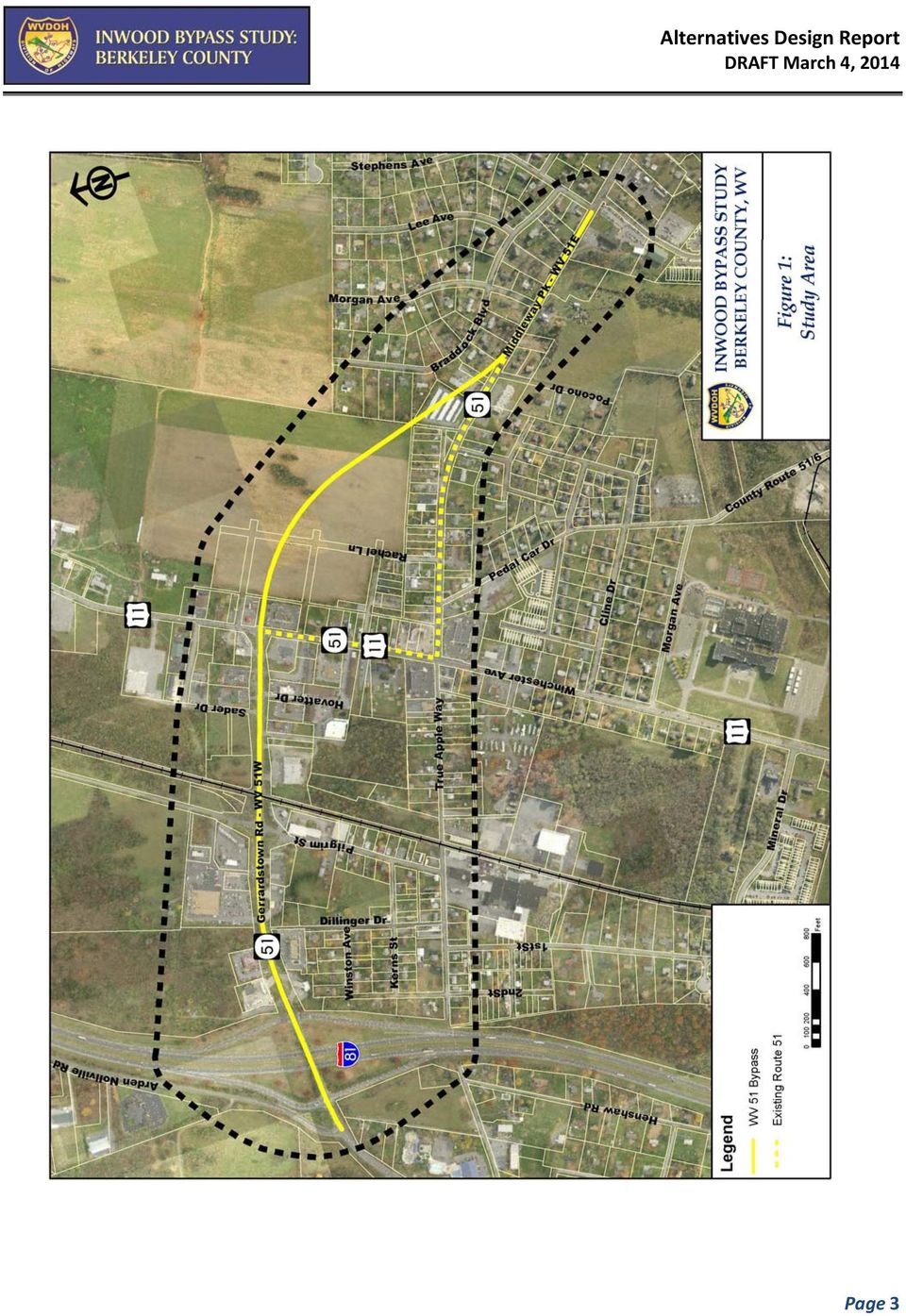
5 congestion and delays at the two intersections. At the present time, there is considerable land space available for additional growth in this region. The past, present, and predicted future growth potential is a clear indicator that the traffic volumes in the Inwood area will continually increase into the foreseeable future. During recent years attempts have been made to mitigate the traffic congestion by the addition of traffic lanes. In the mid 1990 s, a center turn lane was added to US 11 between the offset intersections. At that early stage, turning movements for WV 51 traffic had become evident as additional lanes were being installed. In 2002 a center turn lane was added along WV 51 between I 81 and US 11. The additional lane provided for a right turn lane for eastbound WV 51 traffic. Traffic signals were added at the I 81 ramps in the mid 2000 s to manage the traffic volume and turning movements at the exit ramps. Short leftturning lanes were added on WV 51 at these ramp intersections to provide queuing distance for turning vehicles. More recently, with additional development at the southern intersection of WV 51 and US 11, additional widening for WV 51 westbound, as well as northbound US 11, has been completed by private commercial developers. A southbound right turn lane was added to US 11 for turning movements into a commercial property. The economic downturn that began in 2008 has slowed the residential development to some degree. There has been a noticeable decline in new subdivisions being processed at the county level. That has not stopped the growth of residential housing, as many of the developments that were previously approved have ample lots to build upon. The area continues to see commercial growth. Within the past two years new commercial facilities have been constructed on WV 51 both east and west of US 11. Most recent is the Urgent Care Center situated on the north side of US 11 adjacent to Sader Drive. A Family Dollar retail store has been constructed on the south side of WV 51 near Sulphur Springs Road. The West Virginia Department of Transportation, Division of Highways (WVDOH), in cooperation with the Federal Highway Administration (FHWA), are proposing a new bypass to address congestion and safety concerns and improve traffic operations along WV 51 from Berkeley County 30 just west of I 81 to just east of Pocono Drive in Inwood, West Virginia. In addition to analysis of traffic, the surrounding environment, and potential alternatives in compliance with the National Environmental Policy Act (NEPA), a design alternatives study is being conducted. In concert with the traffic study, this design study will evaluate alternatives and the projected cost to mitigate the traffic congestion issues. For the purpose of this study, the segment of WV 51 between US 11 and I 81 will be referred to as WV 51W. The segment of WV 51 east of the intersection with US 11 to Sulphur Springs Road (CR 51/7) will be referred to as WV 51E. The study area is shown on Figure 1. Photographs shown below provide a visual representation of the existing facilities within the project location. Figure 2 depicts the locations of photos of the existing highway conditions at the offset intersections. Page 2

6 Page 3
7 Figure 2 Existing Intersection Condition Photos Page 4

8 Photo 1, Existing US 11/WV 51W Intersection Looking West toward I 81 Photo 2, Existing US 11/WV 51W Intersection Looking South on US 11 Page 5

9 Photo 3, Existing US 11/WV 51W Intersection Looking North on US 11 Photo 4, Existing US 11/WV 51E Intersection Looking East along WV 51E Page 6

10 Photo 5, Existing US 11/WV 51E Intersection Looking West along WV 51E Photo 6, Existing US 11/WV 51E Intersection Looking North on US 11 Page 7

11 II. ALTERNATIVES DEVELOPMENT This section discusses the range of alternatives considered for the Inwood Bypass Study. There are two primary intersections being evaluated as part of this study: WV 51 and US 11 (offset intersections) located in Inwood, West Virginia (see Figure 1). Reduction in congestion is the primary objective of study alternatives. Although the WV 51 and US 11 intersections are the primary objectives of the study; any improvements along the highway will generate congestion, turning movements, etc. at adjacent intersections. Future growth impacts at the I 81 ramps, Dellinger Drive (CR 11/37), Pilgrim Street (CR 51/4), Sader Drive, Hovatter Drive, Pedal Car Drive (CR 51/6), Surveyor Drive (CR 51/15) and Sulphur Springs Road (CR 51/7) are being evaluated separately. The findings of the traffic study will be provided in the Traffic Technical Report. The purpose of this study is to identify potential alternates that would alleviate traffic congestion and associated delays within the study area and at the identified intersections of WV 51 and US 11. This report will focus on the highway improvements and associated impacts required to provide adequate traffic flow through the project area. Three alternatives are evaluated herein; No Improvements, Improve Roadway on Existing Alignment, Re alignment of WV 51. Detailed mapping of the build alternatives is provided in Appendices A and B. A. ALTERNATE 1 NO BUILD The No Build Alternate is the baseline condition against which other alternate options may be compared. The No Build Alternate includes the existing network of roads and assumes that the currently programmed, committed and funded roadway projects in the study area will be completed, with the exception of the proposed bypass project. Under the No Build condition existing traffic issues would remain and future increased congestion issues would not be addressed. Current traffic conditions indicate that the existing signalized intersections at WV 51 and US 11 are congested and failing under current day standards. If no project work is undertaken, the US 11/WV 51 corridor through Inwood will become gridlock during peak hours. The resulting effect of no improvements would be long traffic delays, increased incidence of traffic accidents, and the associated environmental impacts that occur in heavily congested areas. The 2013 intersection peak hour counts for the two existing intersections at US 11 and WV 51 are shown in Table 1. The projected 2040 No Build traffic counts at these same intersections are shown in Table 2. These tables are taken from the ongoing Traffic Study phase that is part of the overall study. Data for the 2040 scenario indicate that if no improvements are made, traffic counts and congestion will continue to increase. A comparison of the two tables provides a clear view of each intersection and which ones will operate at a level of service F or worse. The center turn lane on US 11 between the offset intersections with WV 51 currently has periods during peak hours whereby the north and southbound traffic competes for the lane space for left turning movements. In addition to the highway traffic, the residential and commercial traffic with entry points along this segment also compete for the turning space. Page 8

12 Projected traffic models provided by the Hagerstown MPO show the future increases in traffic projections. These projected traffic counts show that the intersections would fail with substantial increases in delays. Future traffic increases with no additional storage or stacking room would result in failing intersections. Failure to address the conditions that exist today would magnify the traffic delay and intersection failures as future growth occurs. Added congestion within the study area would likely deter future economic growth. The recent and projected growth over the next few decades indicate that simply leaving the transportation network as is is not a viable option. As such, the No Build Alternative is not recommended but is retained as a baseline condition against which other alternatives may be compared. Page 9

13 Table Existing Intersections Page 10

14 Table Traffic Existing Intersections Page 11

15 B. ALTERNATE 2 - IMPROVE ROADWAY ON EXISTING ALIGNMENT 1. Traffic A Traffic Study has been conducted of the existing intersection. Lane configurations were developed and based upon an operational level of service of D or better. In order to achieve the marginal level of service through the existing corridor, additional lanes will be required on US 11 and WV 51. Based upon this projected traffic growth, WV 51 would need three additional lanes from Interstate 81 to US 11. US 11 would need two additional through lanes and one additional dedicated left turning lane at the signalized intersections. WV 51 east from the US 11 intersection would need two additional through lanes as well as dedicated turning lanes at the traffic signal. The Traffic Study Report suggests that WV 51E be improved to a minimum of three lanes eastward to Sulphur Springs Road. Roadway mapping included in Appendix A depicts the required lane improvements. Berkeley County has adopted the MS4 regulations for stormwater county wide. Therefore, any improvements to the highway system will require water quality treatment as well as quantity control. 2. Description Alternative 2 would improve the existing roadways from west of I 81 to Sulphur Springs Road (CR 51/7). Alternative 2 would consist of improvements to three major roadway segments. Details of the proposed improvements are provided in the subsequent sections. a. US 11 Improvements In order to accommodate the traffic growth projections, US 11 would need widened from the current three lanes to six lanes. Assuming that widening would be symmetric this would require minimum additional pavement width of 18 feet on each side beginning between the WV 51 intersections and for approximately 250 feet to the north and south. In order to allow sufficient traffic movement through the signalized intersections, US 11 would need to be widened to five lanes for a distance of approximately one quarter mile beyond each traffic signal. That improvement would require an additional widening of three lanes in those segments. Total improvement length along US 11 would be approximately 4,200 linear feet or 0.80 miles. This widening would also require additional drainage features, as well as stormwater management to mitigate the increased runoff generated by the impervious surface. Numerous commercial establishments within this corridor would be impacted by this improvement. Additionally, overhead electric, telephone, and cable service is present and would need relocated. Photos 7 through 10 provide a typical view of the property and utility impacts for widening of the existing route. Property impact locations are shown on Figure 3. Page 12

16 Figure 3 US 11 Existing Conditions Page 13

17 Photo 7, US 11 Looking North West Side Photo 8, US 11 Looking South East Side Page 14

18 Photo 9, US 11 Looking South East Side Photo 10, US 11 Looking North Page 15

19 Improving US 11 to meet the recommendations of the Traffic Study would impact thirty three (33) commercial establishments, ten (10) residential dwellings, an elementary school, and a post office. The impacts upon the residential and commercial dwellings on the east side of US 11 would require demolition due to the close proximity to the existing roadway. Highway improvements at the southern intersection of US 11 and WV 51 would require removal of the Sheetz convenience store on the northeast corner and the NAPA auto parts store on the south west corner. The Rite Aid pharmacy on the northwest corner will experience limited access. The extent of widening may eliminate parking and mobility at the CVS pharmacy sufficiently to significantly reduce its functionality. An itemized listing of properties that will be impacted is shown in Table 4. Table 5 provides a listing of parcels that will be taken in their entirety to complete the highway expansion work. The US 11/WV 51 corridor at Inwood experiences minor flooding during peak storm events. The northern intersection at US 11 and WV 51W is situated at a lower elevation than the surrounding properties. Over the decades, development in the periphery of this intersection has most likely altered natural drainage flows. Additional lanes for highway improvements will place additional emphasis on managing runoff. Additional property acquisition will be necessary for stormwater retention detention. Widening on the existing alignment will pose substantial traffic control and constructability issues. Maintaining access to residences and businesses that remain will be of significance. Also, with the current traffic count of approximately 20,000 vehicles per day, temporary traffic control measures will be a significant cost to the project. A summary of probable construction costs is provided later in this section. b. WV 51 West Improvements The intersection of US 11 and WV 51W would need to be widened to accommodate six lanes for turning and traffic flow movements. This would require the addition of three lanes plus additional drainage, shoulders, and radius improvements. The remainder of WV 51 from approximately Hovatter Drive to the southbound ramps west of I 81 would require a minimum of five lanes. The improvements would also require additional shoulders and ditches. Since the current drainage along WV 51 flows eastward from the interstate to US 11, significant ditch structure or swales would be required to manage the storm water flows. WV 51 west of US 11 has sufficient right of way for improvements. However, entrances to numerous commercial establishments would be impacted as well as existing drainage. Improvement work would also impact the existing railroad crossing with Winchester and Western Railway. The railway crossing would need to be widened to accommodate the additional lanes of traffic. The existing railroad crossing flashing light would need to be relocated and most likely expanded. Photo 16 provides a general view of the existing railroad warning lights. As mentioned, the number of lanes on WV 51W needs expanded to five lanes. Currently, there is congestion at the interstate ramps. The left turning storage lanes, particularly for traffic entering the southbound ramp, are minimal. This is due to the short space available beyond the overpass bridge. The condition is similar for eastbound WV 51 traffic turning left onto the northbound ramp. The project traffic growth indicates that without additional through and turning movement space, the I 81 ramps would become significantly congested. Replacement of the existing bridge crossing I 81 would be necessary in order to provide adequate lanes for traffic flow at the interchange ramps. The existing traffic signals at I 81 would need to be reconstructed for the additional lanes. Entrance and exit ramps may require additional widening to provide storage for turning vehicles. Photos 11 thru 14 provide an Page 16

20 overall view of the existing WV 51 westward from US 11. Figure 4 provides locations for the photos. Also see Appendix C for lane configuration required to satisfy traffic study recommendations. The roadway expansion would require total reconstruction of the existing traffic signal at the intersection of US 11 and WV 51W. The traffic report recommends that a traffic signal be considered for Pilgrim Street (CR 51/4) intersection with WV 51W. Due to the added lanes and traffic volumes, safe and efficient turning movements would require a signalized intersection. Nearly all properties fronting WV 51W are either commercial or fast food restaurants. There remain a couple of vacant tracts that have potential for commercial development. In this segment there is sufficient space to widen the roadway within the existing right of way; however entrances to the adjacent properties would be affected. Numerous drainage structures under entrances would need to be replaced or reconstructed. Additional temporary traffic control measures would be considered during the design phase. Current storm water runoff from the existing roadway enters an existing roadside ditch network and flows eastward from I 81 to the intersection of US 11. As stated previously, the roadway surface elevation at the US 11/WV 51W intersection is lower than the approaches in each direction. Photo 17 shown provides visual representation. Peak storm events currently create temporary flooding of this intersection. Improvements to US 11 and WV 51W intersection will alter the current drainage and increase runoff quantities. The improvements to US 11 and WV 51W will require either storm drainage system to pipe storm water to a regional pond or acquire additional property near the intersection to provide retention for the additional discharge generated by the additional impervious surfaces. Increases in stormwater runoff must meet the MS4 requirements of Berkeley County. The general requirements established by the county require that both water quality treatment and quantity control be managed. This aspect would be essential for this improvement project due to the proximity of commercial and residential development that exists around the perimeter of the highway. Page 17

21 Figure 4 General Conditions along WV 51W Page 18
22 Photo 11, WV 51 looking west from US 11 Intersection Photo 12, WV 51 looking east toward US 11 Page 19
23 Photo 13, WV 51 looking west at Pilgrim St. (CR 51/4) Photo 14, Intersection of WV 51W and US 11 Page 20
24 c. WV 51 East Improvements Proposed traffic volumes indicate that WV 51 east (Southern intersection) would require the addition of two lanes for turning movements. These two additional lanes would be required a minimum of one hundred feet beyond Pedal Car Drive (CR 51/6). From Pedal Car Drive to Surveyor Drive (CR 51/15), the highway would need widened to accommodate two additional lanes as well and drainage. The linear distance for the improvements is approximately 1,250 linear feet or 0.24 miles. From Surveyor Drive to Sulphur Springs Road (CR 51/7) one additional lane would be needed. A single lane widening could be accomplished within the existing right of way for all improvements except for utilities. Photos 15 through 17 provide a representative view of WV 51 east. Figure 5 provides location of the photos relative to the project. Plan sheets depicting the lane configuration on WV 51 east for Alternative 2 are included in Appendix C. Improving the existing alignment along WV 51E to the intersection of US 11 would impact 18 commercial parcels as well as 6 residential parcels. Additional right of way will be required for shoulders and drainage along this segment. In addition to the land parcels, commercial billboard relocations would be required, as shown in Photo 17. As the photos show (and confirmed by topographic surveying) the segment of WV 51E is relatively flat. The addition of lanes will require consideration for stormwater management. In order to control additional discharge, additional right of way will be required to construct retention detention facilities. An alternative would be to install storm drainage and pipe storm water to a regional pond. A summary of construction costs is provided later in this section. Page 21
25 Figure 5 Property Impacts Along WV 51E Under Alternative 2 Page 22
26 Photo 15, WV 51 Looking West at Intersection of US 11 Photo 16, WV 51 Looking East near Intersection with US 11 Page 23
27 Photo 17, WV 51 Looking East at Surveyor Drive (CR 51/15) 3. Impacts a. Public Water Facilities Berkeley County Public Service Water District (PSWD) maintains 10 inch water mains within the project limits of this alternate. The 10 inch water line is located on the west side of US 11 south of True Apple Way. At the intersection with WV 51E, the line crosses US 11 and follows the southern edge of the highway to West Lane which is immediately behind the Sheetz convenience store. The water line then crosses WV 51E and follows West Lane (partially undeveloped) beyond the project limit. The PSWD also maintains a 10 inch water line along the north edge of WV 51W from Dellinger Drive to the intersection of US 11. From this point the 10 inch line follows the west edge of US 11 northward. The PSWD maintains a 10 inch water line crossing WV 51W at Pilgrim Street. There are additional small service lines crossing WV 51W as well as US 11. To facilitate widening of US 11 and both WV 51E and WV 51W the 10 inch water lines will need relocation. An estimated cost of relocation work is $140,500. An itemized listing with associated costs is included in the overall construction cost shown in Appendix A. A map of the existing water utilities furnished by the PSWD is shown below as Figure 6. b. Public Sewer Facilities Berkeley County Public Service Sewer District (PSSD) maintains both gravity and force main sanitary sewer systems within the project area. The PSSD maintains an 8 inch gravity sanitary sewer line along the south side of WV 51W from near the railroad crossing to a point in the field behind the United Bank property. The sewer line crosses US 11 at a point close to the existing radius of WV 51W. The remaining line appears to be offset from existing pavement to allow additional widening without impact. Page 24
28 Determination would need made at the time detailed plans are developed. An 8 inch gravity sanitary sewer exists along the north side of WV 51E from a point just east of Pedal Car Drive to just west of Sulphur Springs Road. The sewer line appears to be sufficient distance away from existing roadway to permit highway improvements. Again, a determination of conflict would be made at the time of detailed plan development. The PSSD also maintains service line connections across WV51E and WV 51W at various locations. Depths as shown on furnished plans appear to be sufficient to permit widening work. Estimated cost of sewer line relocation work is $77,300. An itemized listing with associated costs is included in the overall construction cost shown in Appendix A. A map of the existing sewer utilities furnished by the PSSD is shown below as Figure 7. c. Gas Facilities Mountaineer Gas operates underground gas facilities throughout the project limits. Survey information provided indicates that the gas line is located along the north shoulder of WV 51E from approximately Surveyor drive to the intersection with US 11. Additional survey information indicates that the gas line is located along the south side of WV 51W very close to the existing sanitary sewer line. The gas company also furnishes gas along the US 11 corridor. Preliminary conversations with gas company representatives indicate that the gas service line along WV 51E is a high pressure line. For any improvements along WV 51E and US 11 between the intersections, significant relocation of gas lines will be required. The estimated cost of relocating the gas lines is $10,000. d. Overhead Utilities There are overhead utilities locate on both sides of US 11. These utilities are electric, telephone, and cable. The electric lines are three phase serving some of the commercial parcels. The utility poles currently are located from 4 feet to 7 feet off the edge of existing pavement. A total reconstruction of overhead utilities in this corridor would be required for highway expansion along US 11. Photos 18 thru 21 shown below provide a representation of overhead utilities and their proximity to existing roadways. Photo 21 in particular provides the extent of the three phase electric service on the east side of US 11 near the WV 51E intersection. Figure 8 provides a location for the photos taken. Overhead utilities located along WV 51 W appear to be set back sufficiently and may not be impacted by work. Overhead utilities from Surveyor Drive to US 11 will be impacted and require relocation of poles. There are approximately 50 utility poles that would need relocation to permit the widening of the existing highway. In addition to the poles, numerous service connections would need reconstructed. The degree of work required for the utilities will invariably generate disruption of service to the customers along the corridor. Page 25
29 Figure 6 Existing Water Line Mapping Page 26
30 Figure 7 Existing Sewer Line Mapping Page 27
31 e. Right of Way Property Conflicts One of the fundamental issues on highways is access conflicts. For this alternate, primary access issues will be at the signalized intersections. At the north intersection with WV 51W, the addition of three lanes on both US 11 and WV 51W would create a critical access issue for the 7 11 facility (MC6, P16.7) as well as Throckmorton (MC6F, P11). Recommendations for this alternate are to purchase both parcels. It would become virtually impossible for vehicles to enter or exit the facilities. Cost consideration has been included in the right of way cost for this project. The access to United Bank will be maintained by the upgrade of the existing traffic signal. Similarly, there will be considerable access issues at the southern intersection at WV 51E. Rite Aid (MC6J, P105) and CVS (MC6J, P117) pharmacy centers are situated at opposite corners to the intersection. Rite Aid has an existing right in entrance off US 11. Their exit is set back on True Apple Way. Reasonable access can be made with this improvement. CVS has a right in and right out entrance at approximately 150 feet from the intersection on WV 51E. They also maintain an entrance on US 11 at approximately 200 feet from the intersection. Access to CVS may become marginal during peak traffic periods. There is a Sheetz fueling center and convenience store (MC6J, P3, 5, & 115) located on the northeast corner of this intersection. This parcel has underground storage tanks that would be compromised by the highway expansion. A NAPA Auto Parts center (TM6J, P81.1) is located on the southwest corner of the intersection. Road widening will eliminate the minimal parking that currently exists. Access would be very difficult. As such, it is recommended that the Sheetz and NAPA parcels be purchased. The associated cost is included in the right of way estimate shown later in this report. f. Temporary Traffic Control Traffic management during construction would be a major aspect of this alternate. All the road improvements are immediately adjacent to traffic flow. For the existing intersections, minimal roam is available through the current lanes. WV 51E has marginal shoulder area. WV 51W currently has three existing lanes. Three lanes currently exist on US 11. Traffic management would most likely be accomplished by utilizing the center turn lane for one direction of traffic flow or reducing the lane widths to provide sufficient shoulder room to perform the widening work. Contractor s means and methods would determine the need for concrete barriers or other traffic device to protect the work areas. Flaggers would most likely be required for the duration of intersection work. Temporary traffic signals may be utilized to handle lane shifts during non working hours. All traffic control utilized would be in accordance with The Manual on Temporary Traffic Control for Streets and Highways as well as other governing specifications of the WVDOH. Cases A4 and A9 of that Manual would be indicative of the traffic control plan utilized. An integral part of any construction activity for this alternate is that of public media utilization. There are numerous entrances to commercial and residential properties throughout the project limits. Advance notice and daily communications will be required for this project. Public service announcements as well as advance usage of Variable Message Boards (VMB) would be the most important traffic control strategy. Use of traffic control devices, temporary striping, barriers, etc. are included in the cost estimate for this alternate and are shown in Appendix A. Page 28
32 Figure 8 Utilities along US 11 Page 29
33 Photo 18, US 11 East Side Utilities Photo 19, US 11 West Side Utilities Page 30
34 Photo 20, Proximity of Utility Poles to Highway Photo 21, Overhead Utilities at WV 51E Page 31
35 4. Cost There are three primary cost functions with improvements on existing alignment: right of way cost; utility relocation cost; and construction costs. More details are provided in Appendix A. Preliminary plans attached in Appendix C show the impacts on private properties. Improving on the existing alignment will impact at least 62 parcels of property within the project limits. Seventeen (17) of the 62 parcels are considered residential. The remainder serves some commercial purpose. Sixteen (16) parcels will be taken in their entirety. Four (4) of the sixteen are considered residential with the remainder being commercial. There are additional parcels not listed as total take but may have damages to the extent where total acquisition may be necessary. To accommodate stormwater management for increased impervious surface, The Hadavand (MC6J, Parcel 83) and Throckmorton (MC6F, Parcel 11) properties are added as a whole take. This area is located at the low elevation and would be utilized to mitigate increased stormwater runoff from the expansion. The total estimated right of way cost values are based upon Berkeley County Assessor s Office tax records. The values are increased by 40% to account for more accurate appraisal estimates for purchasing. Tables 2 and 3 below provide property information to correspond with the information presented in this section. The estimate is derived from the tax mapping information from Berkeley County. The assessed values of the total take properties are totaled with the 40% inflation value added. Commercial properties are being taxed based upon an average of $6.36 per square foot. Banks, retail stores, etc. are taxed at $8.40 per square foot. Residential properties average $3.00 per square foot. The total estimated cost for right of way for this alternate is $4,600,000. Overhead utility costs are computed by evaluating the total number of poles that would need relocated including approximate number approaching the project limits to permit re alignment of utilities. There are 50 poles that would require relocation for this project. Probable cost to relocate each pole is estimated to be approximately $11,000. The estimated cost for overhead utility relocation is $550,000. The cost to relocate underground utilities is included in the roadway construction cost estimate included in Appendix A. The estimate for water, sewer, and gas relocation work is $227,700. Roadway construction costs would include building demolition, full depth excavation for widening, new drainage system, resurfacing existing roadway pavement, two new traffic signal systems, associated road signage, pavement markings, sediment and erosion control, temporary traffic control, and storm water management retention/detention system to manage discharge. The total estimated cost for construction to improve the existing alignment is approximately $12,282,300. A cost estimate is provided in Appendix A that provides the method and estimated quantities utilized to derive this cost figure. In addition to the proposed roadway work, the Traffic Study shows that the WV 51 bridge and approaches at I 81 does not have sufficient lanes to carry the proposed traffic volume, A new bridge structure is needed on WV 51 over I 81. A comparative cost of the most recent bridge replacement project three miles north at Tabler Station interchange was evaluated. The cost of replacing the bridge, ramp improvements, traffic signals, temporary traffic control on I 81, and other bridge related items would be similar to the Tabler Station project. The construction cost for that project was $11,500,000. Adding for inflation, it is estimated that the Inwood interchange project would be approximately $12,000,000. Page 32
36 Summarizing the total cost of the Improving Roadway on Existing Alignment alternative is as follows: Table 3: Alternate 2 Construction Cost Cost Right of Way $4,600,000 Utilities $777,700 Roadway $12,282,300 Roadway Cost $17,660,000 Bridge $12,000,000 Total Cost w/ Bridge $29,660,000 Table 4 Alternate 2 Parcels Impacted Page 33
37 Table 4 (Cont.) Alternate 2 Parcels Impacted Page 34
38 Table 5 Alternate 2 Total Take Parcels Page 35
39 C. ALTERNATE 3 RE-ALIGNMENT OF WV Traffic A Traffic Study and Report has been conducted that includes a new alignment route. The study incorporated the existing intersections as previously described in Alternate 2. The study developed traffic volumes for the design period thru The results of that study show that the alternate alignment would need a minimum of four lanes (two in each direction) to carry projected traffic volumes. This expansion would be required from Interstate 81 to Sulphur Springs Road. The expansion requirements from the interstate to the intersection of US 11 would be the same as the Improve Existing Alignment alternate (WV 51W) with the exception of the US 11 intersection configuration. WV 51E would need to be three lanes from the newly constructed road reconnect with WV 51 to Sulphur Springs Road. 2. Description Alternate 3 would improve the existing WV 51 from west of I 81 to US 11; improve the roadway on US 11 at the improved intersection; and construct a roadway on a new alignment. The new alignment would eliminate the offset intersections at US 11 and WV 51 and provide for a more direct flow for eastand westbound traffic along WV 51. With the exception of intersections at both ends, the proposed alignment would pass across an undeveloped parcel of property with less impact to existing homes and businesses. Key elements to selecting an alignment are the connecting points at each end. The proposed alignment would need to be configured to match the existing WV 51W segment at the current traffic signal at US 11. Curvature and tie in segments on the eastern end need to meet AASHTO criteria and provide adequate alignment for side road connections. The alignment proposed provides a tangent section that would connect at US 11. On the east end, the desire is to connect the new alignment to existing WV 51 near the end of the existing tangent (near Surveyor Drive). Property and other impacts were evaluated in selecting a terminus. It was found that any alignment would impact developed parcels nearly the same. The selected route appears to minimize the number of access points onto the new road. A re connect with WV 51 from Inwood would adequately serve all adjacent parcels. The alignment evaluated is shown in Appendix D. This alignment maximizes the sight distance along the length of the project and provides smooth transition at each end. a. US 11 Improvements Improvements for US 11 for this alternate alignment would require additional widening mainly from Sader Drive northward about one quarter mile north of the new intersection with WV 51W. US 11 would require six lanes north of the intersection to permit adequate storage for turning vehicles. Northbound vehicles would require two left turning lanes to provide storage. The traffic study recommends these lanes such that the single southbound left turning lane at WV 51E could remain functional. The number of lanes required is in accordance with the Traffic Study completed as part of this project. Additionally, shoulder width, clear zone consideration, lane transition lengths and intersection geometry would be in accordance with WVDOH and AASHTO Standards. The improvements to US 11 would be nearly the same as reported in Alternate 2 at the north intersection except that one less through lane would be required. The construction of an alternate route would eliminate traffic that normally would turn right at the southern intersection to go north on US 11 toward Martinsburg. The intersection would require a complete reconstruction of the existing traffic signal. Construction activities required to improve the highway would generate additional storm water discharge. The existing drainage system is currently inadequate and would become a serious issue if not properly Page 36
40 addressed. It is recommended that stormwater drainage system be developed near the intersection with a retention/detention system installed to manage the discharge. It is proposed that the northeast corner of intersection be utilized as this area may be low enough to permit installation of a retention pond. This area has been evaluated previously as part of the original Inwood Stormwater Project. That project never materialized. There are preliminary plans for that project and a copy is shown in Figure 9 of this report. b. WV 51 West Improvements Improvements required to WV 51 from US 11 to Interstate 81 is essentially the same as previously described in the Alternate 2 narrative. The only exception would be the additional lane configuration at the intersection of US 11. Traffic signals, additional lanes, drainage, and railroad crossing work were previously described. This would also include the need for reconstruction of the I 81 overpass bridge to accommodate the projected traffic flow at the interchange ramps. Refer to Section II B 3 for more detail. As mentioned in the previous paragraph, provisions are needed to manage the stormwater drainage along WV 51W. c. WV 51 East New Alignment Alternate 3 would construct a new segment of road from US 11 through undeveloped property to an easterly connection or tie in with existing WV 51 near Surveyor Drive (CR 51/15). The proposed segment would begin at the current signalized intersection of WV 51W and US 11. Photo 22 provides a general view of where the new alignment would begin. The traffic impact study recommends that this segment of highway have the capacity to carry two lanes of traffic in each direction. Considering the commercial aspects of this area, a five lane roadway would need constructed. That roadway would have pave shoulders in accordance with WVDOH and AASHTO Standards and Policies. The limiting feature of constructing this new by pass route is the probability that the United Bank parcel (MC6F, P13) would need acquired. The Throckmorton property (MC6F, P10 & 11) is recommended for acquisition for this Alternate as well as Alternate 2 in order to provide storm water management for the completed roadway segment. The segment of roadway follows a tangent segment with curves near the east end that conform to AASHTO requirements for a 55 mph roadway. The new segment would have a crest vertical separating the drainage into two discharge areas. This drainage divide would occur at approximately Station The relocated segment of roadway would pass along and require limited acquisition of parcels within the Inwood East Subdivision. The proposed alignment would pass through the South Berkeley Self Storage (MC 6, P57) requiring acquisition of the parcel. Additional parcels to the east would require acquisition. Table 7 is provided later in this section that provides a listing of impacts. Table 8 provides a listing of total acquisition parcels. The new alignment would connect to existing WV 51 at approximately Station or slightly east of Pocono Drive. The traffic impact study also suggests that growth projections indicate that an additional lane be provided on existing WV 51 from the reconnection to Sulphur Springs Road (CR 51/7). There are commercial establishments as well as entrances to substantial subdivisions within that corridor that generate significant left turning movement. WV 51 has a sixty foot right of way within that corridor and thus sufficient to widen the roadway within existing right of way. Existing driveways would be reconstructed with the widening work. Existing WV 51 between the south intersection of US 11 and the newly relocated roadway would be connected by a T intersection at approximately Station Entrances along a portion of the Page 37
41 existing roadway would be connected to permit access. Individual driveways would be eliminated in as much as practical to control access points on the newly constructed roadway. Details of the alignment are shown on plan sheets included as Appendix B in this report. Drainage aspects of the newly constructed roadway would need consideration. Since most of the area is currently open farm field, new impervious surfaces would require water quality as well as quantity treatments. As state previously, Berkeley County Government has adopted MS4 regulations countywide. Credits can be considered for parcels that require demolition or removal of impervious surfaces. The generated impervious area would be substantially greater than any credits and thereby warranting the required treatment. Vegetated swales and potentially bio retention along the length of the newly constructed roadway would provide some credits for the quality treatment and may aid in some quantity control. Additional right of way beyond the projected cut and fill limits is shown in order to accommodate this potential. The actual areas required would be determined once final design begins on the selected alignment. This general area is known for karst topography. There is evidence on this particular project of this existence. Rock outcrops are present in the open field and potentially within the limits of this project. Prior to any final design work, geotechnical exploration should be made of the area to determine the existence of shallow cavities or caverns. This exploration could govern the location and infiltration practices utilized to mitigate stormwater runoff. Photo 23 shows the general location of the alternate alignment. Small rock outcrop is visible in that photograph. A naturally low area currently exists on the north side of existing WV 51 near the east tie in. Acquisition of these parcels would permit the construction of a stormwater detention facility to receive discharge from the highway. The area is shown on the plans in Appendix B. The parcels are also shown in the right of way impact table shown later in this report. Photo 24 provides a general view of the low area as well as the general area where existing WV 51 would connect to the new alignment. Page 38
42 Figure 9 Proposed Stormwater System Page 39
43 Figure 10 WV 51 Proposed Alignment Photos Page 40
44 Photo 22, Alternate Alignment West End Looking East Photo 23, General View of Proposed Alignment Looking East (Note rock outcrop in field) Page 41
45 Photo 24, General View Near East End of Proposed Alignment Looking Northeast (Note: Low area for potential storm water facility) Photo 25, General View Near East End of Proposed Alignment Looking Northeast Page 42
46 3. Impacts a. Public Water Facilities Berkeley County Public Service Water District (PSWD) maintains 10 inch water mains within the study area. The 10 inch water line is located on the north side of WV 51W and extends from the intersection of US 11 to the McDonalds restaurant just east of the I 81 ramps. This same line follows along the west side of US 11 northward beyond the project limits. There is also a 10 inch water main that crosses WV 51W and runs parallel to the west side of Pilgrim Street. At the intersection with WV 51E, the line crosses US 11 and follows the southern edge of the highway to West Lane which is immediately behind the Sheetz convenience store. This water main is located along the undeveloped alley that continues northward beyond the project limits. The PSWD maintains a 16 inch and a 6 inch parallel water main along the edge of the Butler farm field. The 16 inch line continues into the Inwood East Subdivision. The 6 inch line runs parallel to the South Berkeley Mini Storage Facility and crosses WV 51E just east of Surveyor Drive. The 6 incd main continues eastward along the south side of WV 51 beyond the project limits. This proposed relocated alignment will cross the 10 inch main near United Bank and the 6 inch and 16 inch lines near the eastern tie in. It is anticipated that water line relocation will be necessary at these locations. The estimated cost of relocation work $239,400. An itemized listing with associated costs is included in the overall construction cost shown in Appendix B. The existing water utilities furnished by the PSWD are shown on Figure 6. b. Public Sewer Facilities Berkeley County Public Service Sewer District (PSSD) maintains both gravity and force main sanitary sewer systems within the study area. The PSSD maintains an 8 inch gravity sanitary sewer line along the south side of WV 51W from the railroad crossing to a point in the Butler field behind the United Bank property. The sewer line crosses US 11 at a point close to the existing radius of WV 51W. Upon investigation, the remaining line appears to be offset from existing pavement to allow additional widening without impact. Determination of the extent of the impacts would be made during detailed design. An 8 inch gravity sanitary sewer exists along the north side of WV 51E from a point just east of Pedal Car Drive to just west of Sulphur Springs Road. The sewer line appears to be sufficient distance away from existing roadway to permit highway improvements. Again, impacts would be determined during detailed design. The PSSD also maintains service line connections across WV51E and WV 51W at various locations. Depths as shown on furnished plans appear to be sufficient to permit widening work. Manhole lid adjustments and possible relocation may be required where the proposed roadway crosses the existing sewer line. These crossings will occur at both the east and west ends of the proposed new alignment. The estimated cost for relocation work is $42,100. An itemized listing is included in the overall construction cost shown in Appendix B. The existing sewer utilities furnished by the PSSD are shown above as Figure 7. c. Gas Facilities Mountaineer Gas operates underground gas facilities throughout the study area. Survey information provided indicates that the gas line is located along the north shoulder of WV 51E from approximately Surveyor drive to the intersection with US 11. Additional survey information indicates that the gas line is located along the south side of WV 51W close to the existing sanitary sewer line. The gas company also furnishes gas along the US 11 corridor. Preliminary conversations with gas company representatives indicate that the gas service line along WV 51E is a high pressure line. For any Page 43
SEMINOLE PRATT WHITNEY ROAD & NORTHLAKE BLVD. FREQUENTLY ASKED QUESTIONS
 UPDATED: 01/31/14 SEMINOLE PRATT WHITNEY ROAD & NORTHLAKE BLVD. FREQUENTLY ASKED QUESTIONS Q. 1. What are the County s plans for Seminole Pratt Whitney Road between SR 80 (Southern Blvd) and the Bee Line
3.1 Historical Considerations
 3. Recommended Scope of Bridge improvements 3.1 Historical Considerations In the fall of 2000, an outside consultant, Fraser Design, suggested that the existing 4 th St. Bridge is potentially eligible
Comment #1: Provide an interchange at Route 7 and Farm Market Road/White Gate Road. This was studied in the late 1990 s.
 Proposed Truck Climbing Lane Route 7 Westbound Between West Market Street and Route 9 UPC# 58599, Project # 6007-053-133, P101 Date of Meeting: August 24, 2010 Time: 6:00PM to 8:00PM Location: Rust Library
ENGINEERING DESIGN GUIDELINES. for SUBDIVISIONS OR COMMERCIAL DEVELOPMENTS
 ENGINEERING DESIGN GUIDELINES for SUBDIVISIONS OR COMMERCIAL DEVELOPMENTS City of Birmingham Department of Planning, Engineering and Permits Engineering Division Office of the City Engineer 2008 TABLE
3 Tappan Zee Bridge Rehabilitation Options
 3 Tappan Zee Bridge Rehabilitation Options 3.1 Introduction This chapter describes possible options that rehabilitate and enhance the existing Tappan Zee Bridge. Four Rehabilitation Options have been developed:
Chapter Forty-seven. RURAL TWO-LANE/MULTILANE STATE HIGHWAYS (New Construction/Reconstruction) BUREAU OF DESIGN AND ENVIRONMENT MANUAL
 BUREAU OF DESIGN AND ENVIRONMENT MANUAL") Chapter Forty-seven RURAL TWO-LANE/MULTILANE STATE HIGHWAYS (New Construction/Reconstruction) BUREAU OF DESIGN AND ENVIRONMENT MANUAL Illinois RURAL TWO-LANE/MULTILANE STATE HIGHWAYS December 2009 2 Illinois
Chapter Forty-seven RURAL TWO-LANE/MULTILANE STATE HIGHWAYS (New Construction/Reconstruction) BUREAU OF DESIGN AND ENVIRONMENT MANUAL Illinois RURAL TWO-LANE/MULTILANE STATE HIGHWAYS December 2009 2 Illinois
8.1.3 General Design Guidelines. The following guidelines shall be used when designing inlets along a street section:
 . Introduction Presented in this chapter are the criteria and methodology for design and evaluation of storm sewer inlets located in Town of Castle Rock. The review of all planning submittals will be based
APPENDIX C INLETS. The application and types of storm drainage inlets are presented in detail in this Appendix.
 Storm Drainage 13-C-1 APPENDIX C INLETS 1.0 Introduction The application and types of storm drainage inlets are presented in detail in this Appendix. 2.0 Inlet Locations Inlets are required at locations
Section ALTERNATIVES. 3. Alternatives
 Section 3 ALTERNATIVES 3. Alternatives 3.0 Alternatives The Springfield Rail Improvements Project Build Alternatives would utilize different routes. The No Build Alternative includes the continuation of
Land Disturbance, Erosion Control and Stormwater Management Checklist. Walworth County Land Conservation Department
 Land Disturbance, Erosion Control and Stormwater Management Checklist Walworth County Land Conservation Department The following checklist is designed to assist the applicant in complying with the Walworth
14-97. 14-97.002 Definitions. For the purposes of this rule chapter the following definitions shall apply unless the context clearly shows otherwise:
 14-97 14-97.001 Purpose. This rule chapter sets forth an access control classification system and access management standards to implement the State Highway System Access Management Act of 1988. The implementation
Informational Workshop Public Meeting Kanawha Falls Bridge Project
 Informational Workshop Public Meeting Kanawha Falls Project WV Department of Transportation Division of Highways in Cooperation with the Federal Highway Administration State Project S310-13-0.02 00 Federal
CLACKAMAS COUNTY ZONING AND DEVELOPMENT ORDINANCE
 1008 STORM DRAINAGE (3/24/05) 1008.01 PURPOSE To minimize the amount of stormwater runoff resulting from development utilizing nonstructural controls where possible, maintain and improve water quality,
Exhibit A Scope of Work
 Exhibit A Scope of Work The agreement for S.P. 3116-142 (T.H. 169-Cross Range Expressway) includes final design plans for a 1.55 mile length of a 2 lane to 4 lane expansion project located 0.66 miles SW
PLANNED UNIT DEVELOPMENT & SIDEWALK WAIVER REQUEST STAFF REPORT Date: November 7, 2013
 PLANNED UNIT DEVELOPMENT & SIDEWALK WAIVER REQUEST STAFF REPORT Date: November 7, 2013 NAME LOCATION Audubon Properties, LLC. 4700 & 4960 Dauphin Island Parkway West side of Dauphin Island Parkway, 580
SECTION 5 DRAFTING STANDARDS
 SECTION 5 DRAFTING STANDARDS 1 SECTION FIVE TABLE OF CONTENTS Description Page TABLE OF CONTENTS... 5-2 GENERAL... 5-3 DRAFTING STANDARDS... 5-5 DRAFTING MINIMUM REQUIREMENTS HANDOUT... 5-8 2 GENERAL 1.
Guidelines for Fiber Optic Cable Permits
 Guidelines for Fiber Optic Cable Permits NOVA District (Fairfax/Arlington) Permits www.virginiadot.org/business/fairfax-permits-main.asp Email: NOVAFairfaxPermits@VDOT.Virginia.gov 14685 Avion Parkway
Draft Transportation Management Plan for Via Verdi Repair Project
 for Via Verdi Repair Project prepared for City of Richmond This report was prepared by: This report was reviewed by: Ryan McClain, P.E. Fehr & Peers TABLE OF CONTENTS 1.0 INTRODUCTION & PROJECT DESCRIPTION...
Temporary Traffic Control for Building and Maintaining Single and Multi-Lane Roundabouts
 Purpose and Background Temporary Traffic Control for Building and Maintaining Single and Multi-Lane Roundabouts Although roundabouts have recently gained popularity and use in the United States, minimal
Alternatives to the Circ Project Prioritization Methodology Prepared for Circ Task Force July 28, 2011
 Alternatives to the Circ Project Prioritization Methodology Prepared for Circ Task Force July 28, 2011 CCRPC staff has developed a draft methodology described below and detailed in the attached pages for
11 p.m. to. Tuesday, June. will remain open. 14. closed
 June 3, 2011 CONTACT: Marcia McAllister T: 703 572 0506 C: 571 730 9117 marcia.mcallister@dullesmetro.com Important Lane Closures June 5 11 Include Northbound Beltway Lanes, Eastbound Dulles Airport Access
TH 23 Access Management Study Richmond to Paynesville
 TH 23 Access Management Study Richmond to Paynesville Prepared For: Minnesota Department of Transportation District 8 Prepared By: Short Elliott Hendrickson Inc. July 2015 Table of Contents I. Introduction...
1161.01 CONFORMITY WITH PLANS; DRAINAGE.
 CHAPTER 1161 Subdivision Requirements 1161.01 Conformity with plans; drainage 1161.07 Easements 1161.02 Trees 1161.08 Streets 1161.03 Subdivision name 1161.09 Blocks 1161.04 Street names 1161.10 Lots 1161.05
Road Rehabilitation and Reconstruction Using AutoCAD Civil 3D
 Road Rehabilitation and Reconstruction Using AutoCAD Civil 3D Contents Introduction... 3 Introduction to Corridor Targets... 3 Surface Targets... 4 Width and Offset Targets... 5 Elevation or Slope Targets...
Accident Analysis of Sheridan Road between Isabella Street and South Boulevard
 Accident Analysis of Sheridan Road between Isabella Street and South Boulevard Prepared for TranSystems Corporation for the City of Evanston Submitted by Regina Webster & Associates, Inc. Date: 08/15/2008
Mercer County Multi-Modal Transportation Plan Year 2025 Travel Demand Model
 Mercer County Multi-Modal Transportation Plan Year 2025 Travel Demand Model Prepared For West Virginia Department of Transportation Transportation Planning Division Building 5, Room 824 1900 Kanawha Blvd.
Transportation Management Plan Template
 DATE: TO: FROM: SUBJECT: Date Name Position Transportation Service Center Name Position Transportation Service Center Transportation Management Plan Job Number(s) Control Section(s) Route Details County
BEST PRACTICES. Smart Transportation is a key concept for the Paoli Roadway Improvement Project.
 Smart Transportation Smart Transportation is a key concept for the Paoli Roadway Improvement Project. PennDOT s Smart Transportation Guidebook (2008) outlines a comprehensive approach to transportation
1What purpose do guard
 g u a r d F c a b A l e Q f re q u e n t l y a s k e d q u e s t i o n s 1What purpose do guard cables serve? Cross-Median Fatalities The purpose of high-tension guard cable is to prevent vehicles that,
 Page 1 of 6 FLOOD INVESTIGATION INVENTORY SHEET Flood Investigation # 1510082007722 Entry Date: 10/8/2007 2:39:57 PM Revised Date: 7/13/2015 3:11:20 PM Completed By: Hiren Patel, PBS&J SECTION I: LOCATION
Lane Shutdowns and Mobile Operations
 PERFORMANCE ACTIVITY 408 TREE REMOVAL WORK DESCRIPTION 1 WORK DESCRIPTION 2 Fallen Tree Standing Tree 408 TREE REMOVAL ACTIVITY DESCRIPTION Cut and remove tree as necessary. WORK DESCRIPTION 1 Fallen Tree
The Bond Release Process for New Subdivision Developments: An Overview for Homeowners Associations DRAFT 6-4-08. Revised 9-25-08
 The Bond Release Process for New Subdivision Developments: An Overview for Homeowners Associations DRAFT 6-4-08. Revised 9-25-08 Fairfax County requires developers to post a performance bond if they are
FILE NO.: Z-6915-C. Gamble Road Short-form PCD and Land Alteration Variance Request
 FILE NO.: Z-6915-C NAME: Gamble Road Short-form PCD and Land Alteration Variance Request LOCATION: Located on the Northwest corner of Chenal Parkway and Gamble Road DEVELOPER: Davis Properties P.O. Box
Stormwater Management Functional Servicing Report
 Stormwater Management Functional Servicing Report Part of Lot 12, Concession 10 Township of Cavan Monaghan Ian Cameron Rural Subdivision Engage Project No. 14016 Engage Engineering Ltd. January 7, 2015
EXHIBIT A Accessible Truck Routes Map
 EXHIBIT A Accessible Truck Routes Map ASHEVILLE, NORTH CAROLINA ROUTE: A ROUTE: B ROUTE: C ROUTE: D ROUTE: E EXHIBIT A EXHIBIT B Craven Street Improvements Map ASHEVILLE, NORTH CAROLINA EXHIBIT B EXHIBIT
TABLE OF CONTENTS TABLES FIGURES
 TABLE OF CONTENTS Introduction...1 1. On-Site Stacking...2 2. Number of School Driveways...2 3. School Driveway Standards...3 3A. Driveway Spacing...3 3B. Driveway Location...4 3C. Driveway Lane Widths
PUBLIC INFORMATIONAL MEETING THURSDAY APRIL 30, 2015
 PUBLIC INFORMATIONAL MEETING THURSDAY APRIL 30, 2015 AT ACTON TOWN HALL FAULKNER ROOM 472 MAIN STREET ACTON, MASSACHUSETTS 7:00 PM FOR THE PROPOSED ASSABET RIVER RAIL TRAIL (ARRT) IN THE TOWNS OF ACTON
Alternatives Presentation Meeting Middlebury WCRS(23)
") Alternatives Presentation Meeting Middlebury WCRS(23) Main Street (VT 30/TH 2 Bridge 102) and Merchants Row (TH 8 Bridge 2) over Vermont Railway June 4, 2013 Twilight Hall Auditorium, Middlebury College
Alternatives Presentation Meeting Middlebury WCRS(23) Main Street (VT 30/TH 2 Bridge 102) and Merchants Row (TH 8 Bridge 2) over Vermont Railway June 4, 2013 Twilight Hall Auditorium, Middlebury College
PROJECT COST ESTIMATE ASSUMPTIONS AND EXCLUSIONS
 C PROJECT ESTIMATE ASSUMPTIONS AND EXCLUSIONS In support of the alternatives development process, preliminary cost estimates were prepared for each of the three Candidate Build Alternatives. The cost estimates
SR-18 Corridor Improvements in Wood County
 Public Meeting Information Package SR- Corridor Improvements in Wood County Thursday, May 19, 2011 10:00 a.m. to 1:00 p.m. Meeting Location: Hancock-Wood Electric Cooperative Building 1399 Business Park
AGENCY COORDINATION AND PUBLIC INVOLVEMENT
 5 AGENCY COORDINATION AND PUBLIC INVOLVEMENT 5.1 AGENCY COORDINATION As part of the planning process for the Oregon Avenue Final EA, DDOT conducted an agency coordination program. This coordination included
Engineering Department
 Engineering Department Site Plan Review Application 1025 31st St SE PO Box 5006 Minot, ND 58702 engineers@minotnd.org (701) 857-4100 Contact Information Developer/Property Owner Address City State Zip
FOR IMMEDIATE RELEASE September 17, 2013 Contact:
 NEWS RELEASE FOR IMMEDIATE RELEASE September 17, 2013 Contact: Diana L. Klink 757.514.4104 757.359.1845 Tim Kelley 757.514.4103 757.871.3039 UPDATE (Bridge Road/Mills Godwin Bridge) The work scheduled
VILLAS OF TRADITIONS AT GREY OAKS
 Report of Turnover Survey VILLAS OF TRADITIONS AT GREY OAKS Grey Oaks Development Naples, Collier County, Florida Forge Engineering Project Number 2907-001.01 March 2015 Richard P..Lundberg, P.E cn=richard
Improving Access in Florida International University Biscayne Bay Campus Executive Summary
 EXECUTIVE SUMMARY Improving Access in Florida International University Biscayne Bay Campus Executive Summary Prepared for: Miami-Dade County Metropolitan Planning Organization (Miami-Dade MPO) Prepared
Virginia Department of Transportation Rural Rustic Road Program Manual
 Virginia Department of Transportation Rural Rustic Road Program Manual Prepared by Local Assistance Division Virginia Department of Transportation 1401 East Broad Street Richmond, Virginia 23219 Jennifer
CITY UTILITIES DESIGN STANDARDS MANUAL
 CITY UTILITIES DESIGN STANDARDS MANUAL Book 2 (SW) SW9 June 2015 SW9.01 Purpose This Chapter provides information for the design of open channels for the conveyance of stormwater in the City of Fort Wayne.
SECTION III-06 Surfacing Page 1 Revised 3/2/10. See the DESIGN GUIDELINES in Section I-06 for requirements for cross slope of the roadway.
 Page 1 Revised 3/2/10 See the DESIGN GUIDELINES in Section I-06 for requirements for cross slope of the roadway. For New/Reconstruction projects: The cross slope of the driving lanes range from 1.5% to
APPENDICES G) DETAILED BACKBONE INFRASTRUCTURE CONSTRUCTION COST ESTIMATE SUMMARY
 DETAILED BACKBONE INFRASTRUCTURE CONSTRUCTION COST ESTIMATE SUMMARY") ALAMEDA POINT MASTER INFRASTRUCTURE PLAN March 31, 2014 APPENDICES G) DETAILED BACKBONE INFRASTRUCTURE CONSTRUCTION COST ESTIMATE SUMMARY Carlson, Barbee & Gibson, Inc. Backbone Infrastructure Engineer
ALAMEDA POINT MASTER INFRASTRUCTURE PLAN March 31, 2014 APPENDICES G) DETAILED BACKBONE INFRASTRUCTURE CONSTRUCTION COST ESTIMATE SUMMARY Carlson, Barbee & Gibson, Inc. Backbone Infrastructure Engineer
General Utility Work Obligations
 General Utility Work Obligations This Section addresses the Utility Company (or Utility Owner) requirements. It does not apply to existing stormwater facilities, irrigation ditches, Intelligent Transportation
CHAPTER 27 New Public Road Connections. Table of Contents
 Chapter 27 New Public Road Connections Table of Contents CHAPTER 27 New Public Road Connections Table of Contents CHAPTER 27 New Public Road Connections... 27-3 ARTICLE 1 - General... 27-3 Responsibility...
CHAPTERTWO. Alternatives 2.1 ALTERNATIVES DEVELOPMENT PROCESS
 2. Section 2 TWO CHAPTERTWO 2.1 ALTERNATIVES DEVELOPMENT PROCESS This EIS has been prepared in compliance with the Council on Environmental Quality (CEQ) regulations for implementing NEPA (40 CFR 1500-1508).
The Need for Traffic Incident Management
 The Need for Traffic Incident Management With traffic incidents responsible for approximately 50-60% of the congestion delays motorists encounter on the nation s roadways every day, increased roadway capacity
DESCRIPTION OF WORK:
 DEPARTMENT OF PUBLIC WORKS COUNTY OF HENRICO P.O. BOX 27032 RICHMOND, VIRGINIA 23273 PERMIT NO. One (1) copy of application and four (4) copies of plans are hereby made to the Director of Public Works
Chapter 3 SENSITIVE AREAS AND VEGETATED CORRIDORS
 Chapter 3 3.01 General Provisions 3.01.1 Introduction 3.01.2 Application and Interpretation of Chapter 3.01.3 Unbuildable Lots 3.01.4 Other Permits 3.01.5 Prohibited Activities 3.02 Service Provider Letter
Section 6 Traffic Analysis
 Section 6 Traffic Analysis Traffic Operations of the Preferred Network Alternative After the Preferred Network was identified and confirmed by local policy makers and area residents, detailed traffic analysis
720 Contour Grading. General. References. Resources. Definitions
 720 Contour Grading General Contour grading directs water to a desired point, prevents erosion, provides noise deflection, provides visual fit of the facility into the landscape, and protects desirable
DISTRICT 3 TRAFFIC MANAGEMENT PLAN CHECKLIST
 State of California Business, Transportation and Housing Agency DISTRICT 3 TRAFFIC MANAGEMENT PLAN CHECKLIST District / EA: District 3/ EA 03-3E380 Date Prepared: 1/10/2013 Prepared By: Robert Himes Stage
1800 Washington Boulevard, Baltimore, MD 21230-1718 www.mde.maryland.gov 410-537-3000 800-633-6101 TTY Users 800-735-2258 Larry Hogan, Governor Boyd
 ENVIRONMENTAL SITE DESIGN (ESD) REDEVELOPMENT EXAMPLES OCTOBER 2010 1800 Washington Boulevard, Baltimore, MD 21230-1718 www.mde.maryland.gov 410-537-3000 800-633-6101 TTY Users 800-735-2258 Larry Hogan,
LAND USE CODE CHAPTER 18.68 GENERAL REGULATIONS
 CHAPTER 18.68 GENERAL REGULATIONS SECTIONS: 18.68.010 Fences. 18.68.020 Vision Clearance Area. 18.68.030 Access. 18.68.040 Yard Requirements. 18.68.050 Special Setback Requirements. 18.68.070 Land Surveys.
9988 REDWOOD AVENUE PROJECT TRAFFIC IMPACT ANALYSIS. April 24, 2015
 9988 REDWOOD AVENUE PROJECT TRAFFIC IMPACT ANALYSIS April 24, 2015 Kunzman Associates, Inc. 9988 REDWOOD AVENUE PROJECT TRAFFIC IMPACT ANALYSIS April 24, 2015 Prepared by: Bryan Crawford Carl Ballard,
How To Improve Safety
 Collision Diagrams Collision diagrams are used to display and identify similar accident patterns. They provide information on the type and number of accidents; including conditions such as time of day,
CHAPTER 10 PERMIT PROCEDURES AND BONDING REQUIREMENTS FOR CONTRACTORS
 I "i,, I, 1 " CHAPTER 10 PERMIT PROCEDURES AND BONDING REQUIREMENTS FOR CONTRACTORS CHAPTER 10 PERMIT PROCEDURES A N D BONDING REQUIREMENTS FOR CONTRACTORS, Section I -, INDEX :, - % I I,,J Topic b 101
WESTFIELD-WASHINGTON ADVISORY PLAN COMMISSION December 7, 2015 1512-SPP-24 & 1512-ODP-24
 Petition Number: Subject Site Address: Petitioner: Request: East side of Oak Road, north of 151 st Street Langston Development Co. Primary Plat and Overall Development Plan amendment review for Mapleridge
Ne w J e r s e y Tr a f f i c Co n g e s t i o n :
 Ne w J e r s e y Tr a f f i c Co n g e s t i o n : A Growing Crisis January 2008 Cover photo : Route 3, Passaic County introduction A rising tide of traffic congestion threatens to increase roadway gridlock,
Maryland Invests $845 Million in New Highway and Bridge Projects
 Maryland Invests $845 Million in New Highway and Bridge Projects Completing Widening of MD 404 Talbot And Caroline Counties Top Regional Priority Queen Anne s, Talbot, and Caroline Counties Widening MD
Drainage Analysis for the McKownville Area
 Drainage Analysis for the McKownville Area Town of Guilderland Albany County, New York Prepared by: DELAWARE ENGINEERING, P.C. 28 Madison Avenue Extension Albany, New York 12203 June 2010 Town of Guilderland
Surface Transportation Program (STP)
") Project Name: Project Sponsor: FEDERAL FUNDS PROJECT APPLICATION TRANSPORTATION IMPROVEMENT PROGRAM 2008-2013 SALT LAKE and OGDEN/ LAYTON URBAN AREAS Surface Transportation Program (STP) Urban Surface
Project Name: Project Sponsor: FEDERAL FUNDS PROJECT APPLICATION TRANSPORTATION IMPROVEMENT PROGRAM 2008-2013 SALT LAKE and OGDEN/ LAYTON URBAN AREAS Surface Transportation Program (STP) Urban Surface
The checklist utilized by the Authority will be similar to that which is shown below. Project Name: Location: Consulting Engineering Firm:
 Page 1 of 6 Section 1. PURPOSE This policy is an Engineering checklist of the Local Review Program for sanitary sewer improvement projects by the Bedford Regional Water Authority ( Authority ). Section
ENGINEERING SOLUTIONS FOR DESIGNING YOUR SAFE ROUTES
 How to Get Started ENGINEERING SOLUTIONS FOR DESIGNING YOUR SAFE ROUTES Design Elements Selecting appropriate design treatments for school neighborhoods creates environments that address the needs of all
Architectural Processing and Inspections for Home Mortgage Insurance
 Page 1 of 5 [Text Only] Architectural Processing and Inspections for Home Mortgage Insurance Directive Number: 4145.1 SITE GRADING AND DRAINAGE GUIDELINES Construction complaints and structural defect
TRAFFIC IMPACT ANALYSIS
 TRAFFIC IMPACT ANALYSIS Presenter Gerry Harter, PE, Area Traffic Engineer Acting Transportation and Land Use Director Why a TIA? Roads are a critical public resource and a major investment of public funds
5. Environmental Analysis
 5.11 The potential for adverse impacts on utilities and service systems was evaluated based on information concerning current service levels and the ability of the service providers to accommodate the
Highway 138 Corridor Solutions Study Roseburg, Oregon. Technical Memorandum #4: Concept Development and Screening DRAFT
 Highway 138 Corridor Solutions Study Roseburg, Oregon Technical Memorandum #4: DRAFT Prepared for Oregon Department of Transportation, Region 3 3500 NW Stewart Parkway Roseburg, Oregon 97470 Prepared by
BENNINGTON LOCAL ROADWAY NETWORK TRAFFIC ANALYSIS
 Documentation for: BENNINGTON LOCAL ROADWAY NETWORK TRAFFIC ANALYSIS Bennington, VT Prepared for: Bennington County Regional Commission & Town of Bennington August 2003 TABLE OF CONTENTS 1.0 INTRODUCTION...1
PUBLIC WORKS DESIGN, SPECIFICATIONS & PROCEDURES MANUAL LINEAR INFRASTRUCTURE
 REGION OF PEEL PUBLIC WORKS DESIGN, SPECIFICATIONS & PROCEDURES MANUAL LINEAR INFRASTRUCTURE Storm Sewer Design Criteria REVISED July 2009 PUBLIC WORKS STORM SEWER DESIGN CRITERIA TABLE OF CONTENTS 1.0
The total estimated PFC revenue for the application is $266,900,000. The estimated charge effective date for this application is December 1, 2016.
 Public Notice of Application for Authority to Impose and Use Passenger Facility Charges (PFCs) at EWR, LGA, JFK and SWF and Amendment to Approved PFC Applications at EWR, LGA, and JFK The Port Authority
Chapter Thirty-five ACCESS CONTROL/ ACCESS MANAGEMENT BUREAU OF DESIGN AND ENVIRONMENT MANUAL
 Chapter Thirty-five ACCESS CONTROL/ ACCESS MANAGEMENT BUREAU OF DESIGN AND ENVIRONMENT MANUAL Chapter Thirty-five ACCESS CONTROL/ACCESS MANAGEMENT Table of Contents Section Page 35-1 GENERAL CONCEPTS...
EXPERIENCE WITH GEOGRAPHIC INFORMATION SYSTEMS (GIS) / MAPPING
 / MAPPING") EXPERIENCE WITH GEOGRAPHIC INFORMATION SYSTEMS (GIS) / MAPPING TEC has performed many GPS/GIS inventory projects and studies for the Ohio Department of Transportation (ODOT), Counties, and municipalities.
EXPERIENCE WITH GEOGRAPHIC INFORMATION SYSTEMS (GIS) / MAPPING TEC has performed many GPS/GIS inventory projects and studies for the Ohio Department of Transportation (ODOT), Counties, and municipalities.
The financial plan was prepared in conjunction with the Technical Working Group. Refer to Table 3-1: Funding and Implementation Plan.
 3 Financial Plan The purpose of the financial plan is to identify funding options that would be likely sources of money to advance recommendations made by this study. The Capitol Region Transportation
SECTION 08000 STORM DRAINAGE TABLE OF CONTENTS
 SECTION 08000 STORM DRAINAGE 08010 DESIGN A. Location B. Sizing TABLE OF CONTENTS 08020 MATERIALS A. Pipe Materials B. Structure Materials C. Installation D. Inlets and Outlets 08030 INSPECTIONS AND TESTING
Electric Engineering Division FIBER CONDUIT RULES AND REGULATIONS
 Electric Engineering Division FIBER CONDUIT RULES AND REGULATIONS TABLE OF CONTENTS I. RULES AND REGULATIONS A. TABLE OF CONTENTS... 2 B. TERMS AND DEFINITIONS... 3 C. DEVELOPER S/CONTRACTOR S RESPONSIBILITIES...
Effect on structures. Uniform settlement - no concerns. Angular distortion - causes damage due to tensile strain
 Effect on structures Uniform settlement - no concerns Angular distortion - causes damage due to tensile strain 1/500 - safe limit for no cracking of buildings 1/150 - potential structural damage 36 37
Executive Summary. Transportation Needs CHAPTER. Existing Conditions
 CHAPTER 1 Executive Summary The City of Forest Grove Transportation System Plan (TSP) was updated to keep it consistent with recent growth trends in the city and other transportation planning efforts in
Corridor Goals and Objectives
 Corridor Goals and Objectives This chapter presents the goals and objectives, developed by the Corridor Study Committee, that serve as the purpose and intent of the Corridor Plan. This plan covers a twenty
Construction Traffic Management Plan
 Introduction This (CTMP) has been prepared in order to discharge Condition 20 of planning permission ref 07/02879/EFUL for the enabling site works associated with the wider Bath Western Riverside development.
CITY OF VAUGHAN SCHEDULE O LOT GRADING DESIGN FOR RESIDENTIAL DEVELOPMENT
 Page 1 CITY OF VAUGHAN SCHEDULE O LOT GRADING DESIGN FOR RESIDENTIAL DEVELOPMENT CIVIC CENTRE 2141 MAJOR MACKENZIE DRIVE MAPLE ONTARIO L6A 1T1 905-832-2281 Page 2 SECTION 1 - GENERAL OBJECTIVES To provide
Bruce Highway (Cooroy to Curra) Section A (Cooroy southern interchange to Sankeys Road)
 Section A (Cooroy southern interchange to Sankeys Road)") Bruce Highway (Cooroy to Curra) Section A (Cooroy southern interchange to Sankeys Road) Industry Briefing - 13 February 2013 Bruce Highway Upgrade (Cooroy to Curra) The Bruce Highway Upgrade (Cooroy to
Bruce Highway (Cooroy to Curra) Section A (Cooroy southern interchange to Sankeys Road) Industry Briefing - 13 February 2013 Bruce Highway Upgrade (Cooroy to Curra) The Bruce Highway Upgrade (Cooroy to
GEOMETRIC DESIGN CIVL 3161
 GEOMETRIC DESIGN CIVL 3161 Reading Assignment: p. 45-72 (4 th ed.) p.45-75 (previous ed.) in Mannering textbook. Geometric design of highway facilities deals with the proportion of physical elements of
Nashville Area MPO Regional Freight Study fast action projects
 Project #1 Beechcroft road (sr 247) at csx crossing Motor carrier survey location Maury County (Spring Hill, Tn) / City of Spring Hill Current at-grade railway crossing causes traffic delays as a result
IH-635 MANAGED LANES PROJECT, SEG. 3.2
 IH-635 MANAGED LANES PROJECT, SEG. 3.2 Location: Dallas, Texas Owner: Texas Department of Transportation Client: Ferrovial Agroman Construction Cost: $1 Billion Construction Completion Date: December,
How To Amend A Stormwater Ordinance
 Regulatory Alternatives to Address Stormwater Management and Flooding in the Marlboro Street Study Area Alternative 1: Amend Existing Local Regulations This proposed alternative provides an incremental
SECTION 5: SANITARY SEWER SYSTEM DESIGN
 SECTION 5: SANITARY SEWER SYSTEM DESIGN 5.01 GENERAL Sanitary sewer improvements shall be designed to serve the ultimate level of City development as defined in the General Plan and the Wastewater Facilities
Executive Director s Recommendation Commission Meeting: July 11, 2013
 Executive Director s Recommendation Commission Meeting: July 11, 2013 PROJECT Russell Road Widening Phase 2 United States Marine Corps Base Quantico Prince William County, Virginia SUBMITTED BY United
LIMITED SCOPE CONCEPT DEVELOPMENT REPORT
 LIMITED SCOPE CONCEPT DEVELOPMENT REPORT Route 33 Resurfacing Project Eastbound: Milepost 24.2 to Milepost 28.9 Westbound: Milepost 24.3 to Milepost 28.9 Manalapan & Freehold Townships, Monmouth County
APPLICATION LAFAYETTE METROPOLITAN PLANNING ORGANIZATION (MPO) SURFACE TRANSPORTATION PROGRAM (STP) FUNDS TRANSPORTATION IMPROVEMENT PROGRAM (TIP)
 SURFACE TRANSPORTATION PROGRAM (STP) FUNDS TRANSPORTATION IMPROVEMENT PROGRAM (TIP)") APPLICATION LAFAYETTE METROPOLITAN PLANNING ORGANIZATION (MPO) SURFACE TRANSPORTATION PROGRAM (STP) FUNDS TRANSPORTATION IMPROVEMENT PROGRAM (TIP) To be considered for STP funding, a proposed project must
APPLICATION LAFAYETTE METROPOLITAN PLANNING ORGANIZATION (MPO) SURFACE TRANSPORTATION PROGRAM (STP) FUNDS TRANSPORTATION IMPROVEMENT PROGRAM (TIP) To be considered for STP funding, a proposed project must
CHAPTER 10 - PERMIT PROCEDURES AND BONDING REQUIREMENTS
 CHAPTER 10 - PERMIT PROCEDURES AND BONDING REQUIREMENTS 10.1 APPLICATION REQUIREMENTS AND PROCEDURES 10.1.1 A permit shall be required for any construction or installation within the public right-of-way
Transportation Network Analysis. A. Overview
 Transportation Network Analysis A. Overview The goal of this analysis is to evaluate existing roadways and specific intersections within the County. The focus will be on areas identified as probable growth
APPENDIX 9 INFRASTRUCTURE SERVICING REPORT
 APPENDIX 9 INFRASTRUCTURE SERVICING REPORT Lot 50 Cockram Street, Mundijong Infrastructure Servicing Report Peet Ltd August 2012 LOT 50 COCKRAM STREET, MUNDIJONG-INFRASTRUCTURE SERVICING REPORT Project
ADA POST INSPECTION CHECKLIST. Job No. Route County Location
 ADA POST INSPECTION CHECKLIST Job No. Route County Location SIDEWALKS All sidewalks constructed within the project limits are ADA compliant. Sidewalks are 5 or greater in width. Exception, existing sidewalks