REPORT. Impact on Irrigated Land by the Proposed 765kV Perseus-Hydra Transmission Power line
|
|
|
- Domenic Hodges
- 8 years ago
- Views:
Transcription
1 Rehab Green cc Registration No: 2002/094339/23 PI Steenekamp PO Box Queenswood 0121 Pretoria Cell: Fax: Report No: RG/2007/05/14/1 Date: May 2007 REPORT Impact on Irrigated Land by the Proposed 765kV Perseus-Hydra Transmission Power line (Addendum to Environmental Impact Assessment Report, P.I. Steenekamp, (Scoping document) Requested By ARCUS GIBB (Pty) Ltd Compiled By Rehab Green Monitoring Consultants CC Environmental and Rehabilitation Monitoring Consultant cc P.I. Steenekamp (Cert.Sci.Nat.)

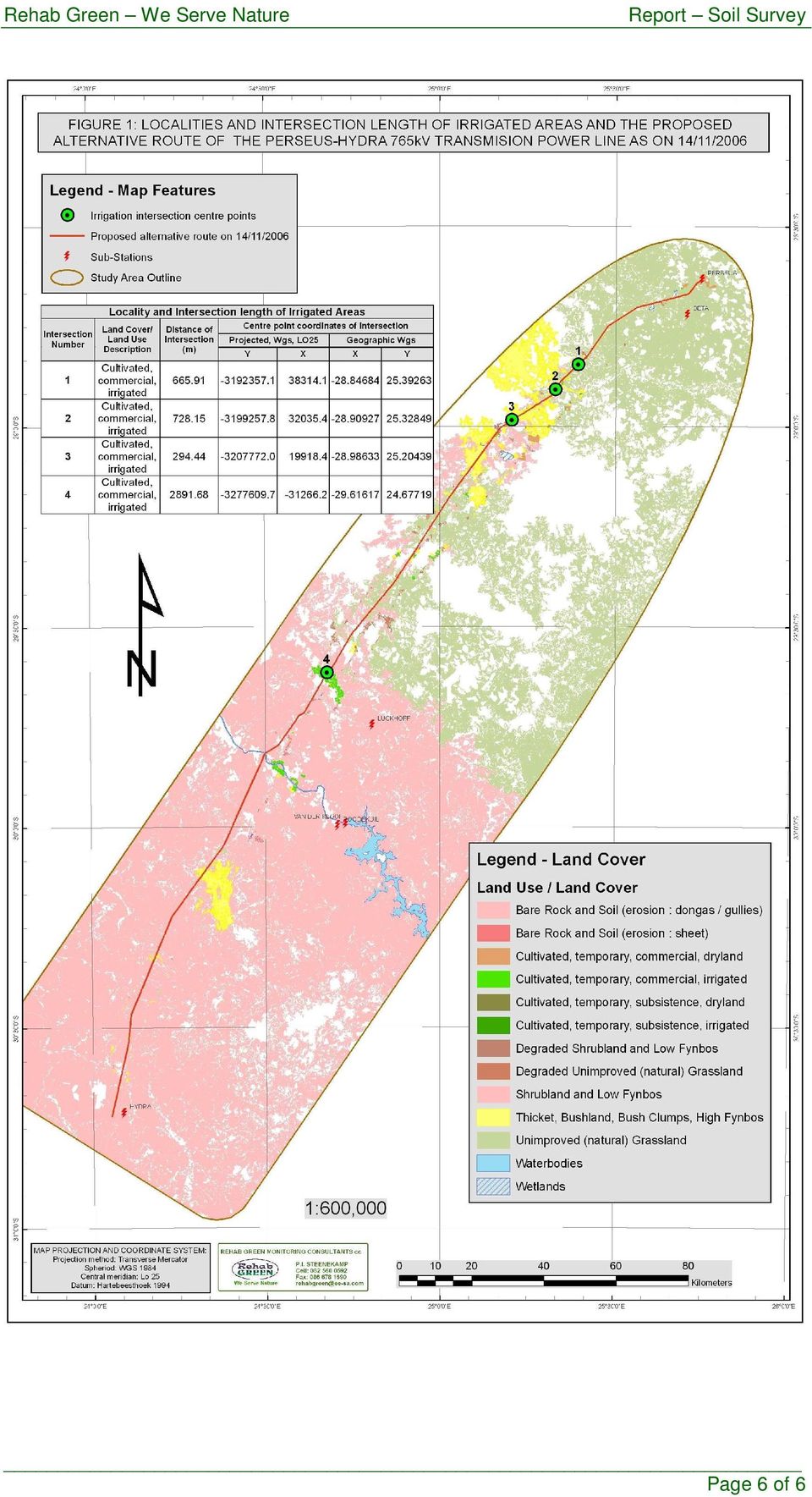
2 CONTENTS Page 1. TERMS OF REFERENCE 3 2. METHODOLOGY STUDY RESULTS CONCLUSION RECOMMENDATION.. 4 REFERENCES FIGURES: Figure 1: Localities of intersections. Page 2 of 6

3 1. TERMS OF REFERENCE Rehab Green Monitoring Consultants cc was requested by ARCUS GIBB (Pty) Ltd to assess the impact on irrigated areas along the proposed Perseus-Hydra 765 kv alternative routes as follows. Quantification of existing irrigation that would be affected by each alternative route and the effects of the alternatives on future irrigation plans (related to soils and availability of irrigation water). On the basis of this information, rank the alternatives in respect of impact on irrigation agriculture. Provide more detail about irrigation agriculture, including the problems associated with transmission towers in irrigation lands and what restrictions there are if any on ongoing irrigation. These issues are addressed in the soil impact assessment report (scoping document) by P.I. Steenekamp, 2005 for the alternative routes proposed at that stage. However, the major impact on irrigated land by power lines is the obstructions of irrigation systems such as centre pivots. Suitable locations for the erection of centre pivots are also bound to suitable soil types and often further obstructed by roads, farm boundaries, farm houses etc. Such restrictions often prevent the use of such systems at full capacity which seriously hamper the economic viability of such a system. Such obstructions often lead to low productivity of high potential land or even total withdrawal of land which can not be utilized effectively with preferred irrigation systems. One tower placed at the wrong position can therefore permanently prevent the use of a centre pivots at a specific place. The proposed route dated 14/11/2006 as supplied by ARCUS GIBB deviate to some extent from the previous 3 alternative routes and therefore a reassessment of the impact of irrigated land was done. 2. METHODOLOGY The impact on irrigated areas was determined by superimposing the alternative route on the national land cover data layer. All intersections with irrigated areas were extracted and the length was calculated. 3. STUDY RESULTS Four intersections of irrigated areas were identified and shown in Figure 1. Table 1 gives the distance/length of each intersection as well as the coordinates of the centre point in a projected and geographic format. Table 1: Locality and Intersection length of Irrigated Areas Intersection Number Land Cover/ Land Use Description Distance of Intersection (m) Centre point coordinates of intersection Projected, Wgs, LO25 Geographic Wgs Y X X Y 1 Cultivated, commercial, irrigated Cultivated, commercial, irrigated Cultivated, commercial, irrigated Cultivated, commercial, irrigated Page 3 of 6
. On the basis of this information, rank the alternatives in respect of impact on irrigation agriculture.")
4 4. CONCLUSION The length of intersections 1, 2 and 3 varies between 294 and 665 meters. The intersections cuts through the edges of irrigated lands (mainly centre pivots) according the land cover layer and can be avoided by slight deviation of the line direction and/or manipulations of the positions of towers. The length of intersection 4 is 2891 m and might not be possible to avoid obstruction of centre pivots by manipulation of the position of towers or minor deviation of the line direction. It however appear that the proposed route cuts through a narrow corridor on the edges of a number of centre pivot units. 5. RECOMMENDATIONS Obstruction of irrigation systems at intersections 1, 2 and 3 can probably be avoided by proper spacing of towers and/or minor deviations of the line direction. A much more prominent corridor between centre pivot units occurs approximately 1 km east of the current proposed route which can be considered at intersection 4. A proper and detail field assessment should be done at large irrigated areas to determine the most suitable route to minimize the impact. Towers without anchor lines should be used to decrease the area of impact. Keeping routes along farm boundaries and roads will definitely decrease the impact in most cases because irrigation systems seldom stretch across farms or roads. It will also largely prevent obstruction of possible future irrigation developments. REFERENCES Thompson M.W, South African National Land-cover Database Project Data Users Final Report (Phase 1, 2 and 3), Pretoria: CSIR Environmentek (1999). Page 4 of 6

5 Figures Page 5 of 6

6 Page 6 of 6
Development plan template. Development plan Stage 1. Part 1: Applicant s information. Part 2: Vegetation clearing particulars
 Development plan template This template contains all the requirements for lodging a development plan. Once you have completed this template and attached the required additional information, you need to
Council Policy for New Telecommunication Facilities
 Council Policy for New Telecommunication Facilities 1. Purpose To establish policies and procedures for the installation of new telecommunication antennas, towers and related structures which emphasize
SESSION 8: GEOGRAPHIC INFORMATION SYSTEMS AND MAP PROJECTIONS
 SESSION 8: GEOGRAPHIC INFORMATION SYSTEMS AND MAP PROJECTIONS KEY CONCEPTS: In this session we will look at: Geographic information systems and Map projections. Content that needs to be covered for examination
Living with Electricity Easements
 The Basslink electricity interconnector spans a total of 370 kilometers, from Georgetown in Tasmania, across Bass Straight to Gippsland where it connects with the Victorian electricity grid at Loy Yang.
16 Rankings On First Page. 30 Total Keywords. KEYWORD RANKINGS We are tracking Benchmark Date and Current Ranking. Ranking Changes Improved
 Keyword Rankings harmonygroup.co.za 0 Total Keywords 8 Rankings On First Page 6 Rankings On First Page 7 Rankings On Second Page 7 Ranking Changes Improved NA Ranking Changes Declined KEYWORD RANKINGS
Mapping Application for Resource Planning
 Mapping Application for Resource Planning Wyoming Association of Conservation Districts Cathy Rosenthal, WACD Nephi Cole, NRCS SuiteWater Concept Create an Internet application to support WACD Natural
GEOGRAPHIC INFORMATION SYSTEMS Lecture 11: Land Division Systems
 GEOGRAPHIC INFORMATION SYSTEMS Lecture 11: Land Division Systems Land Division Systems - in many applications of GIS, land ownership is an important data layer and it is important for GIS users to be familiar
ANSWERS TO COMMONLY ASKED QUESTIONS ABOUT AGRICULTURAL LAND VALUE IN KANSAS
 ANSWERS TO COMMONLY ASKED QUESTIONS ABOUT AGRICULTURAL LAND VALUE IN KANSAS By The Ag Use Section Property Valuation Division (PVD) March 26 th 2013 General Questions: Who establishes the appraised value
TRAFFIC MANAGEMENT PLAN
 TRAFFIC MANAGEMENT PLAN For: The construction and operation of a Photovoltaic (PV) Facility in Dabenoris, South Africa Prepared for: Alternative Energy Solutions (Pty) Ltd PO Box 4939 Tygervalley, South
Renewable Energy Mandates Cost Texas Consumers. Bill Peacock Texas Public Policy Foundation
 Renewable Energy Mandates Cost Texas Consumers Bill Peacock Texas Public Policy Foundation Why Advocates Support Renewable Energy Mandates Mandates promote a sensible energy policy which Protects against
Grid connection of near shore wind farms
 Grid connection of near shore wind farms methods, preconditions and results Rene Starup 5. Marts 2015 1 Topics Methods Preconditions Technical and socio-economic analysis 5. Marts 2015 2 60, 150 and 400
Black Mountain Reservoir Land Rezoning
 Black Mountain Reservoir Rezoning Information Meeting Black Mountain Reservoir Rezoning 1.0 Black Mountain Reservoir What the reservoir provides The Black Mountain Reservoir will be a low-elevation raw
Problems and Measures Regarding Waste 1 Management and 3R Era of public health improvement Situation subsequent to the Meiji Restoration

Great River Energy Corridor Management Project
 Great River Energy Corridor Management Project A subproject of GRE s Enterprise GIS Project Mike Siedschlag GIS Tech II United Services Group/ Great River Energy Topics GRE Transmission Facts Corridor
Landforms form an integral part
 Landform classification using GIS by Karsten Drescher, Terralogix Consulting, and Willem de Frey, Ekoinfo Refining existing landform classifications using ESRI s model builder. Landforms form an integral
Project Matching: Facilitating New Renewable Energy Projects Project Proposal Submittal Form
 RE-Powering America s Land Project Matching: Facilitating New Renewable Energy Projects Project Proposal Submittal Form The EPA Green Power Partnership s (GPP s) Project Matching Initiative works to connect
Natural Resource-Based Planning*
 Natural Resource-Based Planning* Planning, when done well, is among the most powerful tools available to communities. A solid plan, based on good natural resource information, guides rational land-use
How To Get A Better Deal On Power From Powerline Power From Pse
 ELECTRICITY RATES FOR COMMERCIAL AND INDUSTRIAL CUSTOMERS Rates Effective January 1, 2010 If you would like information about our services, details about your rights and responsibilities, or a copy of
The Characterisation of Six Natural Resources Production Systems. J. Taylor, M. Tang, C. Beddows, F.M. Quin, M.A. Stocking
 The Characterisation of Six Natural Resources Production Systems J. Taylor, M. Tang, C. Beddows, F.M. Quin, M.A. Stocking August 2003 We wish to thank the following people and projects for supplying the
Tutorial Creating a regular grid for point sampling
 This tutorial describes how to use the fishnet, clip, and optionally the buffer tools in ArcGIS 10 to generate a regularly-spaced grid of sampling points inside a polygon layer. The steps below should
Application of Space Technology for Disaster monitoring and assessment current state in Vietnam
 Application of Space Technology for Disaster monitoring and assessment current state in Vietnam Lai Anh Khoi SPACE TECHNOLOGY INSTITUTE 8th GEOSS Asian Pacific Symposium Beijing, Sep. 09-11, 2015 Types
Frequently Asked Transmission Pipeline Questions
 Frequently Asked Transmission Pipeline Questions Who is PennEast, LLC? PennEast was formed by the partnership of AGL Resources, NJR Pipeline Company, South Jersey Industries and UGI Energy Services (UGIES).
Benefits of Geothermal Energy By Dr. Silas Simiyu
 Benefits of Geothermal Energy By Dr. Silas Simiyu Introduction Geo means Thermal means Intoduction The Earth Crust Mantle Outer core Inner core Is renewable and sustainable Reservoir managed well (Re-injection)
THE OBJECTIVES AND FRAMEWORK FOR THE DEVELOPMENT OF FORUS
 What Forus will be CONTENTS WHY A JOINT PLAN FOR FORUS?... 3 WHAT IS A PLAN PROGRAMME?... 3 THE OBJECTIVES AND FRAMEWORK FOR THE DEVELOPMENT OF FORUS... 3 THE PLAN AREA... 4 THE LONG-TERM GOALS FOR FORUS...
Title 10 DEPARTMENT OF NATURAL RESOURCES Division 35 Land Survey Chapter 1 Cadastral Mapping Standards
 Title 10 DEPARTMENT OF NATURAL RESOURCES Division 35 Land Survey Chapter 1 Cadastral Mapping Standards 10 CSR 35-1.010 Application of Standards PURPOSE: These minimum standards provide the digital mapper
Remote Sensing and GIS Application In Change Detection Study In Urban Zone Using Multi Temporal Satellite
 Remote Sensing and GIS Application In Change Detection Study In Urban Zone Using Multi Temporal Satellite R.Manonmani, G.Mary Divya Suganya Institute of Remote Sensing, Anna University, Chennai 600 025
2012 CEEI Floor Area Methodology - Residential, Commercial, and Industrial Buildings
 2012 CEEI Methodology - Residential, Commercial, and Buildings 1.1. Protocol and Guiding Principles In order to improve understanding of the building characteristics at a neighbourhood level, the BC Assessment
Amex Site Residential Development, Tarneit
 Amex Site Residential Development, Tarneit Local Area Traffic Management Report Client: Amex Corporation Project No. 114430 Draft Report 13/12/13 Suite 1, 1 st Floor 132 Upper Heidelberg Road Ivanhoe Vic
Application form for a Practice Number for a Drug and Alcohol Rehabilitation Centre
 B o ard o f Health car e Fund er s o f S ou th ern A fr i ca Non-Profit Company Registration No. 2001/003387/08 Lower Ground Floor, South Tower, 1Sixty Jan Smuts, Jan Smuts Ave, cnr Tyrwhitt Ave, Rosebank,
SOILS AND AGRICULTURAL POTENTIAL FOR THE PROPOSED P166 ROAD, NEAR MBOMBELA, MPUMALANGA PROVINCE
 REPORT On contract research for SSI SOILS AND AGRICULTURAL POTENTIAL FOR THE PROPOSED P166 ROAD, NEAR MBOMBELA, MPUMALANGA PROVINCE By D.G. Paterson (Pr. Nat. Sci. 400463/04) October 2012 Report No. GW/A/2012/48
MICRO-GRIDS FOR RURAL ELECTRIFICATION Case Study from Zambia on the Zengamina Micro-Hydro Power Grid
 MICRO-GRIDS FOR RURAL ELECTRIFICATION Case Study from Zambia on the Zengamina Micro-Hydro Power Grid Presentation by Energy Regulation Board, Zambia 79 th IEC General Assembly Workshop for Industrialising
28.0 Development Permit Area #2 (Neighbourhood District)
") 28.0 Development Permit Area #2 (Neighbourhood District) Goals and Objectives To provide a guide for infill and new development in the Neighbourhood District. To outline the nature, form and character
28.0 Development Permit Area #2 (Neighbourhood District) Goals and Objectives To provide a guide for infill and new development in the Neighbourhood District. To outline the nature, form and character
The Effect of GIS Data Quality on Infrastructure Planning: School Accessibility in the City of Tshwane, South Africa
 The Effect of GIS Data Quality on Infrastructure Planning: School Accessibility in the City of Tshwane, South Africa Dr Peter Schmitz 1,2, Sanet Eksteen 3 1 CSIR Built Environment, pschmitz@csir.co.za
Gibson Bay Wind Farm. NERSA Hearings Cape Town. 20 February 2014. NERSA Hearing. 20 February 2014
 Gibson Bay Wind Farm s Cape Town GIBSON BAY WIND FARM OVERVIEW KOUGA WIND FARM OVERVIEW 37 Turbines 111 MW Nordex 3.0 MW N117 turbines Hub height of 91 m Wind farm area 4,300 Hectares Actual footprint
Sample Micro Hydro Initial Report
 Sample Micro Hydro Initial Report Sample Micro Hydro Initial Report Introduction The Hydro Burn at Glen Water was visited by Richard Haworth of Glen Hydro to assess its suitability for a micro hydro installation.
Customer connection enquiry form (For the connection of loads and generators)
") Customer connection enquiry form (For the connection of loads and generators) Please provide as much detail as possible to ensure TasNetworks can meet your requirements. When completed please attach and
Customer connection enquiry form (For the connection of loads and generators) Please provide as much detail as possible to ensure TasNetworks can meet your requirements. When completed please attach and
STATE OF ALASKA DEPARTMENT OF NATURAL RESOURCES DIVISION OF MINING, LAND AND WATER. GENERAL SURVEY INSTRUCTIONS EASEMENTS Authority 11 AAC 53
 STATE OF ALASKA DEPARTMENT OF NATURAL RESOURCES DIVISION OF MINING, LAND AND WATER GENERAL SURVEY INSTRUCTIONS EASEMENTS Authority 11 AAC 53 These instructions define the survey and platting criteria unique
Tutorial 8 Raster Data Analysis
 Objectives Tutorial 8 Raster Data Analysis This tutorial is designed to introduce you to a basic set of raster-based analyses including: 1. Displaying Digital Elevation Model (DEM) 2. Slope calculations
INDIANA BOARD OF TAX REVIEW Small Claims Final Determination Findings and Conclusions
 INDIANA BOARD OF TAX REVIEW Small Claims Final Determination Findings and Conclusions Petition: Petitioner: Respondent: Jasper County Assessor Parcel: 37-09-08-000-015.000-031 Assessment Year: 2012 The
DISASTER DISASTER MANAGEMENT CRISIS INFORMATICS GIS IN DIFFEERENT STAGES OF DISASTER MANAGEMENT
 APPLICATION OF GIS AND REMOTE SENSING IN DISASTER PRONE AREAS: A CASE STUDY IN COASTAL KERALA DISASTER Disaster is an unpleasant event than occurs with little or no warning which results in economic disruption,
IDBI Green Bond Framework
 IDBI Green Bond Framework Background IDBI Bank Ltd. is a Universal Bank with its operations driven by a cutting edge core Banking IT platform. The Bank offers personalized banking and financial solutions
Assessing the implementation of Rawalpindi s Guided Development Plan through GIS and Remote Sensing Muhammad Adeel
 Assessing the implementation of Rawalpindi s Guided Development Plan through GIS and Remote Sensing Muhammad Adeel (Lecturer Muhammad Adeel, Institute of Geographical Information Systems, NUST, H-12 Islamabad,
Measuring of optical output and attenuation
 Measuring of optical output and attenuation THEORY Measuring of optical output is the fundamental part of measuring in optoelectronics. The importance of an optical power meter can be compared to an ammeter
Defining the Smart Grid WAN
 Defining the Smart Grid WAN WHITE PAPER Trilliant helps leading utilities and energy retailers achieve their smart grid visions through the Trilliant Communications Platform, the only communications platform
Survey and Mapping Activities in Vietnam *
 UNITED NATIONS E/CONF.100/CRP.1 ECONOMIC AND SOCIAL COUNCIL Eighteenth United Nations Regional Cartographic Conference for Asia and the Pacific Bangkok, 26-29 October 2009 Item 7(a) of the provisional
GIS Solutions for FTTx Design. David Nelson, GISP
 GIS Solutions for FTTx Design David Nelson, GISP Telecom GIS Manager, Black & Veatch Agenda Intro to GIS Telecom GIS Vision GIS Strategy Project Execution Mobile Online Services Dashboards Client Deliverables
What is GIS. What is GIS? University of Tsukuba. What do you image of GIS? Copyright(C) ESRI Japan Corporation. All rights reserved.
 ESRI Japan Corporation. All rights reserved.") What is GIS University of Tsukuba Graduate School of Life and Environmental Science April 21 st, 2011 What is GIS? What do you image of GIS? Gas Insulated Switch Groupe Interventional Speciale Geographic
What is GIS University of Tsukuba Graduate School of Life and Environmental Science April 21 st, 2011 What is GIS? What do you image of GIS? Gas Insulated Switch Groupe Interventional Speciale Geographic
COOK STRAIT SUBMARINE CABLE PROTECTION ZONE
 COOK STRAIT SUBMARINE CABLE PROTECTION ZONE An information brochure on the Submarine Cable Protection Zone across Cook Strait and how it affects mariners, fishers, divers and the public. February 2011
The Western Cape Premier s Entrepreneurship Recognition Awards 2015
 The Western Cape Premier s Entrepreneurship Recognition Awards 2015 Official Entry Form ABOUT THE AWARDS The Western Cape Premier s Entrepreneurship Recognition Awards 2015 is the third edition of an annual
Integration of GIS and Multivariate Statistical Analysis in Master Plan Study on Integrated Agricultural Development in Lao PDR
 Integration of GIS and Multivariate Statistical Analysis in Master Plan Study on Integrated Agricultural Development in Lao PDR GIS Makoto ISHIZUKA, Tetsunari GEJO, Shigeya OOTSUKA and Yukiyasu SUMI GIS
Bell Mobility has submitted an application for a Radiocommunication Antenna System at 1360 Bloomington Road East (see location map below).
.") Cell Phone Tower Proposal Bell Mobility has submitted an application for a Radiocommunication Antenna System at 1360 Bloomington Road East (see location map below). Bell is proposing a 40 m high self-support
Cell Phone Tower Proposal Bell Mobility has submitted an application for a Radiocommunication Antenna System at 1360 Bloomington Road East (see location map below). Bell is proposing a 40 m high self-support
Feasibility Study Mzimvubu Water Project
 Feasibility Study Mzimvubu Water Project Newsletter 2/September 2013 Activities and Achievements to Date A Detailed Feasibility Study is underway in the Eastern Cape to investigate a potential site for
Helicopter Flight Paths and Proposed Design and Development Overlay Area - 1 -
 Attachment 1 Helicopter Flight Paths and Proposed Design and Development Overlay Area - 1 - Attachment 2 Ballarat Health Services Letter to Surrounding Residents - 2 - Attachment 2 Ballarat Health Services
PREPARATION OF BASE MAPS FOR MASTER PLANS
 Bangalore Metropolitan Region Developm ent Authority PREPARATION OF BASE MAPS FOR MASTER PLANS A case study of Bangalore Metropolitan Region Shantappa B. Honnur Additional Director of Town and Country
Introduction to Imagery and Raster Data in ArcGIS
 Esri International User Conference San Diego, California Technical Workshops July 25, 2012 Introduction to Imagery and Raster Data in ArcGIS Simon Woo slides Cody Benkelman - demos Overview of Presentation
State of Green Infrastructure in the Gauteng City-Region
 State of Green Infrastructure in the Gauteng City-Region Valuing Natural Capital Dialogue City of Johannesburg 26 th February 2014 Kerry Bobbins Researcher GCRO kerry.bobbins@gcro.ac.za Overview Structure
NON-TECHNICAL SUMMARY OF ENVIRONMENTAL AND SOCIAL IMPACT ASSESSMENT FOR THE BAHCE WINDFARM PROJECT (135 MW)
") Zorlu Plaza, 34310 Avcılar ISTANBUL / TURKIYE Tel: + 90 (212) 456-2300 Fax: +90 (212) 422-0099 www.zorlu.com.tr NON-TECHNICAL SUMMARY OF ENVIRONMENTAL AND SOCIAL IMPACT ASSESSMENT FOR THE BAHCE WINDFARM
Zorlu Plaza, 34310 Avcılar ISTANBUL / TURKIYE Tel: + 90 (212) 456-2300 Fax: +90 (212) 422-0099 www.zorlu.com.tr NON-TECHNICAL SUMMARY OF ENVIRONMENTAL AND SOCIAL IMPACT ASSESSMENT FOR THE BAHCE WINDFARM
Workshop on Rehabilitation of Hydropower
 Workshop on Rehabilitation of Hydropower World Bank HQ, Washington DC October 12-13, 2011 Prioritizing Rehabilitation Projects for Hydro Plants Outline of the Presentation Topics to be Covered The Task
Wind turbines on your land. Renewable energy development for landowners
 Wind turbines on your land Renewable energy development for landowners Diversification By diversifying into wind energy, landowners have an opportunity to receive a regular, guaranteed income for up to
Analysis Concept and Methodology for Market Selection for IDE India Projects
 Analysis Concept and Methodology for Market Selection for IDE India Projects Eric Weiss IDE M&E and MER Consultant October, 2002 Delhi, India Table of Contents 1.0 Introduction...2 2.0 Methodology Concept...2
EXHIBIT A LOCATION MAP AND LAND USE INFORMATION
 EXHIBIT A LOCATION MAP AND LAND USE INFORMATION In accordance with Arizona Corporation Commission Rules of Practice and Procedure R14-3-219, Applicant provides the following location maps and land use
Dated Tuesday, 24 March 2015
 Dated Tuesday, 24 March 2015 «PROJECT_NAME» Landlord(s (1 GREEN ENERGY COMMERCIAL LTD Tenant LEASE relating to premises known as «LOCATION» and the airspace thereabove PARTICULARS PART 1 : LAND REGISTRY
An Introduction to High Voltage Direct Current (HVDC) Underground Cables
 Underground Cables") Page 1 An Introduction to High Voltage Direct Current (HVDC) Underground Cables Brussels, 10 October 2011 An Introduction to High Voltage Direct Current (HVDC) Underground Cables Page 2 Table of content
Page 1 An Introduction to High Voltage Direct Current (HVDC) Underground Cables Brussels, 10 October 2011 An Introduction to High Voltage Direct Current (HVDC) Underground Cables Page 2 Table of content
Spatial data analysis: retrieval, (re)classification and measurement operations
classification and measurement operations") CHAPTER 7 Spatial data analysis: retrieval, (re)classification and measurement operations In chapter 5 you used a number of table window operations, such as calculations, aggregations, and table joining,
CHAPTER 7 Spatial data analysis: retrieval, (re)classification and measurement operations In chapter 5 you used a number of table window operations, such as calculations, aggregations, and table joining,
NEW DIGITAL TERRAIN MODELING (DTM) TOOLS FOR CABLE ROUTE PLANNING by Dr. Jose M. Andres Makai Ocean Engineering Inc.
 TOOLS FOR CABLE ROUTE PLANNING by Dr. Jose M. Andres Makai Ocean Engineering Inc.") NEW DIGITAL TERRAIN MODELING (DTM) TOOLS FOR CABLE ROUTE PLANNING by Dr. Jose M. Andres Makai Ocean Engineering Inc. EXISTING CABLE ROUTE PLANNING TOOLS In recent years, methods used for submarine cable
NEW DIGITAL TERRAIN MODELING (DTM) TOOLS FOR CABLE ROUTE PLANNING by Dr. Jose M. Andres Makai Ocean Engineering Inc. EXISTING CABLE ROUTE PLANNING TOOLS In recent years, methods used for submarine cable
ArcGIS Online. Visualizing Data: Tutorial 3 of 4. Created by: Julianna Kelly
 ArcGIS Online Visualizing Data: Tutorial 3 of 4 2014 Created by: Julianna Kelly Contents of This Tutorial The Goal of This Tutorial In this tutorial we will learn about the analysis tools that ArcGIS Online
Effect of Using Magnetized Treated Water in Irrigation of Bell Pepper and Beans in AL-Jeftlik Area / West Bank Palestine
 Effect of Using Magnetized Treated Water in Irrigation of Bell Pepper and Beans in AL-Jeftlik Area / West Bank Palestine Dia Radeideh Dia Karajeh Nawaf Abu Khalaf Amer Marei 25,Feb,2015 HOW TO MANGE WATER
APPLICATION FORM TO REGISTER ON THE SUPPLIER DATABASE OF THE SOUTH AFRICAN LOCAL GOVERNMENT ASSOCIATION (SALGA)
") Menlyn Corporate Park Block B 175 Corobay Avenue Waterkloof Glen Ext 11 Pretoria Tel: 012 369 8000 APPLICATION FORM TO REGISTER ON THE SUPPLIER DATABASE OF THE SOUTH AFRICAN LOCAL GOVERNMENT ASSOCIATION
Menlyn Corporate Park Block B 175 Corobay Avenue Waterkloof Glen Ext 11 Pretoria Tel: 012 369 8000 APPLICATION FORM TO REGISTER ON THE SUPPLIER DATABASE OF THE SOUTH AFRICAN LOCAL GOVERNMENT ASSOCIATION
datacentersites.com www.datacentersites.com Security, Infrastructure Redundancy Tier 3+/Tier 4 Data Center Sites
 datacentersites.com Tier 3+/Tier 4 Data Center Sites Home of Apple s $1 billion, 500,000sf data center and two 20+ MW solar facilities NC Data Center Corridor home to nearby data centers for Facebook,
Speaker Summary Note
 2020 CONFERENCE MAY 2014 Session: Speaker: Speaker Summary Note Building Resilience by Innovating and Investing in Agricultural Systems Mark Rosegrant Director, Environment and Production Technology Division
Rural Settlement Patterns
 Rural Settlement Patterns A summary with pictures. Courtesy of Crescent School There are three types of rural settlement patterns that occurred where large numbers of people settled: the long lots of
By Manitoba Hydro, March 4 th 2013
 Rebuttal to Bipole III Coalition underground cable report Potential Use of Underground Cables for Sections of the Planned 500 kvdc Bipole III Overhead Line in Manitoba By Manitoba Hydro, March 4 th 2013
DIVISION D ELECTRICITY, GAS, WATER AND WASTE SERVICES
 The Electricity, Gas, Water and Waste Services Division comprises units engaged in the provision of electricity; gas through mains systems; water; drainage; and sewage services. This division also includes
Photovoltaic in Mexico Recent Developments and Future
 Photovoltaic in Mexico Recent Developments and Future Rodolfo Martínez Strevel Berlin, Germany May 23th, 2013 Bufete de Tecnología Solar, S.A. (BUTECSA) Production of Primary Energy in Mexico, 2011 % 7,0
Medial Axis Construction and Applications in 3D Wireless Sensor Networks
 Medial Axis Construction and Applications in 3D Wireless Sensor Networks Su Xia, Ning Ding, Miao Jin, Hongyi Wu, and Yang Yang Presenter: Hongyi Wu University of Louisiana at Lafayette Outline Introduction
Roseman Technology Site *Caroline County, Virginia 110 Acres Seconds off Interstate 95
 Roseman Technology Site *Caroline County, Virginia 110 Acres Seconds off Interstate 95 Water Service Provider: Caroline Location: I - 95 Route 639, Ladysmith Exit 110 County Suitable for Construction:110
What is well-located land? Spatializing the city for Outcome 8 delivery
 7 What is well-located land? Spatializing the city for Outcome 8 delivery Introduction The release of the National Development Plan (NDP 2010 2011) has increased South Africa s focus on spatial planning.
APPENDIX F RIGHTS-OF-WAY PRESERVATION GUIDELINES
 Los Angeles County Metropolitan Transportation Authority (Metro) 2009 Transportation Improvement Program Call for Projects APPENDIX F RIGHTS-OF-WAY PRESERVATION GUIDELINES Los Angeles County Metropolitan
FRCC Standards Handbook. FRCC Automatic Underfrequency Load Shedding Program. Revision Date: July 2003
 F R C C FRCC Standards Handbook FRCC Automatic Underfrequency Load Shedding Program Revision Date: July 2003 FRCC Underfrequency Load Shedding Program Modification and Approval Process Requests to modify
Webinar Basics. 5. If at any time you experience technical difficulties, please call the C.A.S.H. office at (916) 448-8577.
 448-8577.") Webinar Basics 1. You must dial in on a phone line to hear the audio portion of this webinar. Please refer to your webinar registration confirmation for the dial in instructions. 2. The handouts for this
Webinar Basics 1. You must dial in on a phone line to hear the audio portion of this webinar. Please refer to your webinar registration confirmation for the dial in instructions. 2. The handouts for this
218 Dancer Dr, Hamilton, NJ 08610
 This Property Brochure is STRICTLY for HNPS Investors and associates only. All Properties are normally sold within 14 days from the date listed. Please check the status of the unit with us before beginning
Submarine Power Cables. State-of-the-art production facility, more than 100 years of experience and reference installations around the world.
 Submarine Power Cables State-of-the-art production facility, more than 100 years of experience and reference installations around the world. Reliable submarine power cables ABB is one of the world s most
Using Geographical Information Systems (GIS) To Establish Access To Aged Care Residential Services In Non-Metropolitan Australia
 To Establish Access To Aged Care Residential Services In Non-Metropolitan Australia") Using Geographical Information Systems (GIS) To Establish Access To Aged Care Residential Services In Non-Metropolitan Australia Graeme Hugo, Rachel Aylward 5th National Rural Health Conference Graeme
Using Geographical Information Systems (GIS) To Establish Access To Aged Care Residential Services In Non-Metropolitan Australia Graeme Hugo, Rachel Aylward 5th National Rural Health Conference Graeme
Wind Energy Development in Jamaica
 ACCELERATING ADVANCED ENERGY TECHNOLOGIES Wind Energy Development in Jamaica Group Managing Director, Petroleum Corporation of Jamaica Presentation Outline Country Profile Jamaica Case Study: Wind Energy
ArcGIS Agricultural Land Use Maps from the Mississippi Cropland Data Layer
 ArcGIS Agricultural Land Use Maps from the Mississippi Cropland Data Layer Fred L. Shore, Ph.D. Mississippi Department of Agriculture and Commerce Jackson, MS, USA fred_shore@nass.usda.gov Rick Mueller
Performance Evaluation of Community Based Irrigation Management in the Tekeze Basin
 Performance Evaluation of Community Based Irrigation Management in the Tekeze Basin A case study on three small-scale irrigation schemes (micro dams) Mintesinot Behailu, Mohammed Abdulkadir, Atinkut Mezgebu
Title 10 DEPARTMENT OF NATURAL RESOURCES Division 35 Land Survey Chapter 1 Cadastral Mapping Standards
 Title 10 DEPARTMENT OF NATURAL RESOURCES Division 35 Land Survey Chapter 1 Cadastral Mapping Standards 10 CSR 35-1.010 Application of Standards PURPOSE: These minimum standards provide the digital mapper
BEFORE THE ARKANSAS PUBLIC SERVICE COMMISSION'^^ j E DIRECT TESTIMONY RAJESH GUPTA PROJECT MANAGER, ENTERGY SERVICES, INC.
 BEFORE THE ARKANSAS PUBLIC SERVICE COMMISSION'^^ j E s : D IN THE MATTER OF THE APPLICATION OF ENTERGY ARKANSAS, INC. FOR A CERTIFICATE OF ENVIRONMENTAL COMPATIBILITY AND PUBLIC NEED TO CONSTRUCT AND OPERATE
HV Submarine Cable Systems Design, Testing and Installation
 HV Submarine Cable Systems Design, Testing and Installation CIGRE Ireland Technical Seminar 6 th October 2010 Robert Donaghy Senior Consultant Engineer, ESB International Presentation Overview Applications
Road Rehabilitation and Reconstruction Using AutoCAD Civil 3D
 Road Rehabilitation and Reconstruction Using AutoCAD Civil 3D Contents Introduction... 3 Introduction to Corridor Targets... 3 Surface Targets... 4 Width and Offset Targets... 5 Elevation or Slope Targets...
HVDC Light Cables. Submarine and land power cables
 HV Light Cables Submarine and land s The HV Light s to offshore platform The light and robust HV Light s can be laid with very cost effecient methods HV Light System HV Light is a transmission system in
FAQ s 1. What is GPS? 2. How does GPS work? 3. What is GPRS? 4. How does your device communicate?
 1. What is GPS? GPS is an acronym that stands for Global Positioning System. GPS is one of a few satellite navigational systems; however it is the only fully functional system currently in service. GPS
Topology and Topological Rules Geometric properties that are maintained in spatial databases
 Topology and Topological Rules Geometric properties that are maintained in spatial databases The definition of topology Topology is a term used around GIS that is sometimes confused with the term topography.
EdM ZESA Eskom. Transaction Advisory Services for the
 EdM ZESA Eskom Transaction Advisory Services for the MO-ZI-SA TRANSMISSION PROJECT Terms of Reference for the consulting services for Feasibility Studies up to Financial Close 11 December 2014 TOR_MOZISA-11
GPS Applications in Agriculture. Gary T. Roberson Agricultural Machinery Systems
 GPS Applications in Agriculture Gary T. Roberson Agricultural Machinery Systems What is a Positioning System? A position information system enables the user to determine absolute or relative location of
ADWR GIS Metadata Policy
 ADWR GIS Metadata Policy 1 PURPOSE OF POLICY.. 3 INTRODUCTION.... 4 What is metadata?... 4 Why is it important? 4 When to fill metadata...4 STANDARDS. 5 FGDC content standards for geospatial metadata...5
The potential impact of South Africa s current intermodal strategies on national transport costs
 The potential impact of South Africa s current intermodal strategies on national transport costs SARF 2014, CSIR Convention Centre, Pretoria 4 September 2014 Nadia Viljoen Growth and Intelligence Network
Shannon Corner Service Centre, 208-212 Burlington Road, New Malden, KT3 4NP
 Shannon Corner Service Centre, 08-1 Burlington Road, New Malden, KT NP S1 Total site area (ha) 0.05ha Current MOT Car Repair Undeveloped land (ha) 0 Number of units 1 Grid reference TQ 680 Sequential status
GIS: Geographic Information Systems A short introduction
 GIS: Geographic Information Systems A short introduction Outline The Center for Digital Scholarship What is GIS? Data types GIS software and analysis Campus GIS resources Center for Digital Scholarship
GIS a Tool for Transportation Infrastructure Planning in Ghana A Case Study to the Department of Feeder Roads
 GIS a Tool for Transportation Infrastructure Planning in Ghana A Case Study to the Department of Stephen Yao FIATORNU, Ghana Key words: SUMMARY With the development of GIS technology, network transportation