Stakeholder Meetings Restoration Project Viewer and Water Supply Forecast Tracking Tool
|
|
|
- Kory Daniel
- 8 years ago
- Views:
Transcription
1 Stakeholder Meetings Restoration Project Viewer and Water Supply Forecast Tracking Tool Presented by: Stephanie L. Johnson, Ph.D., P.E. Mark R. Deutschman, Ph.D., P.E. Houston Engineering, Inc. Minneapolis, Minnesota Dan Keppen Keppen and Associates Klamath Falls, Oregon Presented to: Klamath Basin Stakeholders Klamath Falls, Oregon Presented on behalf of: Klamath County Klamath Falls, Oregon


2 Document Guiding DSS Development
3 DSS Framework and Status

4 Klamathhttp://klamathcounty.houstoneng.com Map HEi Hosting Hosting and maintenance contract in place County updating layers

5 Demonstration Goals Concept refresher Activities completed since last meeting Technical challenges encountered Demonstrate beta version of application Present ideas for completion / feedback Obtain comments / direction for completing application

6 County Commissioner Meeting Klamath Map Demonstration Water Supply Tracking Tool Demonstration Restoration Project Viewer Demonstration Discuss Next Steps

7 Water Supply Forecast Tracking Tool (WSFTT) Goal is to enhance and improve products but avoid duplication of current products. This application is more mature than the Restoration Project Viewer.

8 Current NRCS Forecast Products Water supply forecasts are issued by the Natural Resources Conservation Service monthly beginning in January and ending in June of each year.

9 Our Original Concept

10 Our Evolved WSFTT Concept Understand how seasonal forecast volume is revised during a water year Compare historic seasonal forecast volumes (from NRCS) to actual runoff volumes (from USGS/BoR) Provide indication of the timing of future water supply based on the seasonal forecast volume Retrieve historic forecasts Access real-time data (through WatershedViewer)

11 WSFTT Facts Daily download of stream flow and reservoir stages from agency ftp locations automated Downloaded data stored in database Calculations fully programmed Graphs use free Fusion Charts Little maintenance needed if Agency data locations remain unchanged Data storage format remains unchanged Using typical streamflowpatterns to estimate future volumes Can access through Watershed Viewer OR tools page

12 Watershed Viewer

13 WSFTT Four Charting Tools

14 Real-Time Data

15 Current & Historic Seasonal Forecast Volume

16 Compare Actual and Forecast Volumes

17 Estimated Timing of Future Forecast Volume

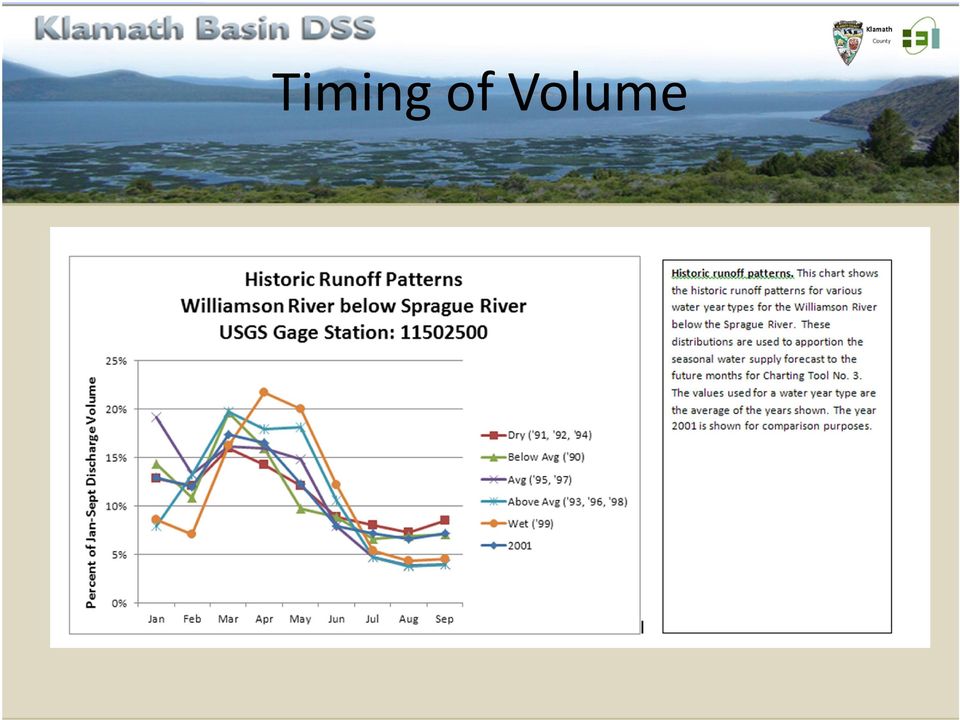
18 Timing of Volume
19 Items to Consider Accuracy of forecast volumes Forecast volume apportioned according to gage Close to answering questions Compare real-time flow to BIOP Compare real-time UKL lake levels to BIOP Understand water availability for decisions Maintenance..

20 Finalizing the WSFTT Stakeholder feedback Revise given limitations (vision challenge) Public release (county approval)
 Public release")

21 UKL Water Level Forecasts
22 Synergistic Activities Klamath Basin DSS NOAA Regional Drought DSS Real-time products Model results Satellite data Basin water reports Capitalizing on multiple project allows sharing of products / tools / technologies.
23 Restoration Project Viewer
24 Background Continuation of Klamath DSS Grant received by Klamath County From Fremont-Winema USFS Goal: Develop and integrate a watershed restoration web application into the existing Klamath Basin DSS
25 Original Concept Geographic scope (Fremont-Winema National Forest) Potential to expand it to the whole Klamath Watershed Portal for searching and viewing restoration activities Interactive map and database Making USFS WIT database accessible to external users Integration of external organizations restoration activities Potential stakeholders: USFW, BLM, NRCS, Klamath County, KWP, etc. Tools for entering new activities and projects by external users Tools for identifying new restoration sites
26 Last Time (i.e., November) Had 4 databases no WIT Layers by Activity to highlight tool concepts Stakeholder feedback was to concentrate on database first
27 Current Viewer Now have 6 databases 2,283 sites (previously 890 sites) Retained fish/water conservation tool layers for future potential
28 Details on Progress Added WIT and CHRPD (CA Habitat Restoration Project Database) data Increased Activities in the watershed from 890 to 2,228 Redesigned common schema based on WIT data Created code to automate database compilation process Added new query/identify functionality
29 Schema ACTIVITY TABLE ID (HEI-created)* Database Activity Site ID Project ID Activity Site Name Local Name Activity Site Class Activity Type Code Site Type Class Site Type Code Treatment Class Treatment Code Treatment Description Acres Accomplished Miles Accomplished Stream Miles Accessed PROJECT TABLE ID (HEI-created)* Database Project Name Project Objective Admin Code 1 Admin Name 1 Admin Code 2 Admin Name 2 Admin Code 3 Admin Name 3 State FUNDING TABLE ID (HEI-created)* Database Phase Type Description Fiscal Year Implemented Total Cost Funding Source Funding Code Funding Code Description Amount Funded AGENCY TABLE ID (HEI-created)* Database Agency *HEI created ID = database_ + database unique ID
30 Fitting the Data to the Schema Note: no consistently filled categories difficult to use single category for general classification
31 New Query/Identify Functions
32 Decisions Classifying type of restoration project None Manually re-classifying the 2,220 activities in the database Agencies re-classify Searching / Query on what and how Reporting a report that prints and allows you to see all the restoration activities for a given project (or similar)
33 Example: Searching / Querying by Project N Fork Sprague Habitat Culvert Process Query by project (using dropdown) Associated activities selected on map Identify information for each activity
34 Example: Project Report
35 Items to Consider Issue with Project Names Public and private version? Maintenance Updating databases
36 URLs Klamath Map Water Supply Forecast Tracking Tool Restoration Project Viewer
37 Thanks & Acknowledgement County Board (the vision) Lani Hickey Randy Paul and Bruce (Klamath Map) Amy Gowan (Restoration database / viewer)
Communities and Fire Restoration. The Role of Communities in Restoring Fire as a Natural Process
 Communities and Fire Restoration The Role of Communities in Restoring Fire as a Natural Process Overview 1. Frequent fire regimes dominate approximately 65% of the lower 48 states, although regional variations
Natural Resource-Based Planning*
 Natural Resource-Based Planning* Planning, when done well, is among the most powerful tools available to communities. A solid plan, based on good natural resource information, guides rational land-use
Case Study: The History of the San Juan Headwaters Forest Health Partnership
 Case Study: The History of the San Juan Headwaters Forest Health Partnership Introduction: Wildfire is a part of life in Southwest Colorado. It plays an integral role in ecosystem health and management.
Project Theory-Climate Change and Traditional Ecological Knowledge Adaption in the Klamath Basin
 Project Theory-Climate Change and Traditional Ecological Knowledge Adaption in the Klamath Basin Frank K. Lake Lead Science and TEK Mentor for project Education 1995 B.S. University of California, Davis.
LEAGUE NOTES ON APPROVED COMMUNITY WATER SUPPLY PLAN
 1 AUGUST 2011 LEAGUE NOTES ON APPROVED COMMUNITY WATER SUPPLY PLAN KEY ELEMENTS OF THE PLAN: 1. Replace the existing unsafe Ragged Mountain dam with a new dam and raise the reservoir pool level initially
Mapping Application for Resource Planning
 Mapping Application for Resource Planning Wyoming Association of Conservation Districts Cathy Rosenthal, WACD Nephi Cole, NRCS SuiteWater Concept Create an Internet application to support WACD Natural
TENNESSEE GAS PIPELINE COMPANY, L.L.C.
 TENNESSEE GAS PIPELINE COMPANY, L.L.C. HYDROLOGIC & HYDRAULIC CALCULATIONS FOR WATERBODIES CROSSED BY CONNECTICUT PIPELINE EXPANSION PROJECT CONNECTICUT LOOP Submitted by: Tennessee Gas Pipeline Company,
How To Manage Water Resources In The Yakima Basin
 Yakima Basin Integrated Water Resource Management Plan October 23, 2014 Presented by Derek Sandison, Director Office of Columbia River Photo Courtesy of Tom Ring Basin size: 6,155 sq. miles Population:
MAPPING MINNEAPOLIS URBAN TREE CANOPY. Why is Tree Canopy Important? Project Background. Mapping Minneapolis Urban Tree Canopy.
 MAPPING MINNEAPOLIS URBAN TREE CANOPY Why is Tree Canopy Important? Trees are an important component of urban environments. In addition to their aesthetic value, trees have significant economic and environmental
Henry Van Offelen Natural Resource Scientist MN Center for Environmental Advocacy hvanoffelen@mncenter.org
 Henry Van Offelen Natural Resource Scientist MN Center for Environmental Advocacy hvanoffelen@mncenter.org Wetland study slide Water Quality NRE goals in watershed plans Protect habitat that remains.
Klamath Tracking and Accounting Program Vision
 Klamath Tracking and Accounting Program Vision September 2010 The Klamath Basin Water Quality Improvement Tracking and Accounting Program (Klamath TAP) is being developed to support Klamath Basin restoration
The NIDIS Pilot in the Upper Colorado River Basin
 The NIDIS Pilot in the Upper Colorado River Basin Jim Verdin (USGS), Roger Pulwarty (NOAA), Nolan Doesken (CSU), Mike Gillespie (NRCS), Kevin Werner (NOAA), Olga Wilhelmi (NCAR), Michael Lewis (USGS),
Emery, Gary GIS Coordinator, Fisheries Dept, Hoopa Valley Tribe, P.O. Box 417, Hoopa, CA 95546; phone (530) 625-4267 x 22; email: gis@pcweb.
 625-4267 x 22; email: gis@pcweb.") USING DYNAMIC SEGMENTATION IN A VECTOR GIS TO DISPLAY, MODEL AND ANALYZE FISH RANGE AND DISTRIBUTION, HABITAT CONDITION, SPAWNING AND RESTORATION ACTIVITIES EVENT DATA Boberg, Jerry Six Rivers National
USING DYNAMIC SEGMENTATION IN A VECTOR GIS TO DISPLAY, MODEL AND ANALYZE FISH RANGE AND DISTRIBUTION, HABITAT CONDITION, SPAWNING AND RESTORATION ACTIVITIES EVENT DATA Boberg, Jerry Six Rivers National
THE WATER AGENCY, INC. Water Supply Update
 State Water Resources Control Board Suspends the Sacramento River Temperature Plan We all need to be aware that the SWRCB is causing real turmoil with its recent May 29th letter. The temporary grab of
Public Land Management and Interdependent Collection of Programs
 FS Agreement Number: 00-SU-11130142-080 MASTER SERVICE-WIDE MEMORANDUM OF UNDERSTANDING Between the EASTERN LANDS AND RESOURCES COUNCIL THE WESTERN STATES LAND COMMISSIONERS ASSOCIATION And the UNITED
Quick Guide to Monitoring Economic Impacts of Ecosystem Restoration and Stewardship
 Ecosystem Workforce Program Summer 2011 Quick Guide to Monitoring Economic Impacts of Ecosystem Restoration and Stewardship Institute for a Sustainable Environment 2 Quick Guide to Monitoring Economic
The Economics of Culvert Replacement: Fish Passage in Eastern Maine
 The Economics of Culvert Replacement: Fish Passage in Eastern Maine Introduction The Natural Resources Conservation Service (NRCS) in Maine is working with Project SHARE (Salmon Habitat and River Enhancement)
Appendix A. Lists of Accomplishments and Project Costs. UMRWD 10 Year Plan Update. Appendix A UPPER MINNESOTA RIVER WATERSHED DISTRICT
 UPPER MINNESOTA RIVER WATERSHED DISTRICT Lists of Accomplishments and Project Costs 10 Year Plan Update UMRWD 10 Year Plan Update Page A 1 UMRWD LIST OF ACCOMPLISHMENTS Since its inception in 1967, the
Flood Risk Management
 Flood Risk Management Value of Flood Risk Management Every year floods sweep through communities across the United States taking lives, destroying property, shutting down businesses, harming the environment
Flood Risk Management
 Flood Risk Management Value of Flood Risk Management Value to Individuals and Communities Every year floods sweep through communities across the United States taking lives, destroying property, shutting
Better than Ever : Partnership of Community Liaisons, USFS & Incident Management Cohesive Strategy Success Story
 Better than Ever : Partnership of Community Liaisons, USFS & Incident Management Cohesive Strategy Success Story State: California Goal 2: Fire Adapted Communities They listened and did what they said
MATCHMAKERS, EVALUATORS, LIBRARIES, AND NETWORKS: ONLINE RESOURCES FOR LANDOWNERS AND PRACTITIONERS
 PAYMENTS FOR ECOSYSTEM SERVICES FACT SHEET SERIES MATCHMAKERS, EVALUATORS, LIBRARIES, AND NETWORKS: ONLINE RESOURCES FOR LANDOWNERS AND PRACTITIONERS FACT SHEET ELEVEN SPRING 2013 This fact sheet series
Restoring Anadromous Fish Habitat in Big Canyon Creek Watershed. Summary Report 2002
 Restoring Anadromous Fish Habitat in Big Canyon Creek Watershed Summary Report 2002 DOE/BP-00005268-5 November 2002 This Document should be cited as follows: "Restoring Anadromous Fish Habitat in Big Canyon
EPA s Conditional Approval of Delaware s Revised Draft BMP Verification Program Plans January 26, 2016
 EPA s Conditional Approval of Delaware s Revised Draft BMP Verification Program Plans January 26, 2016 EPA has conditionally approved Delaware s November 14, 2015 revised draft BMP verification program
SWAMP DATA MANAGEMENT PLAN
 SWAMP DATA MANAGEMENT PLAN Station Template Surface Water Ambient Monitoring Program August 27, 2013 TABLE OF CONTENTS C. Data Entry...3 D. Field Data Entry...3 1. PROGRAMS NEEDED FOR SWAMP DATA ENTRY
UPPER COLUMBIA BASIN NETWORK VEGETATION CLASSIFICATION AND MAPPING PROGRAM
 UPPER COLUMBIA BASIN NETWORK VEGETATION CLASSIFICATION AND MAPPING PROGRAM The Upper Columbia Basin Network (UCBN) includes nine parks with significant natural resources in the states of Idaho, Montana,
Hydrologic Engineering Techniques for Regional Water Resources Planning
 US Army Corps of Engineers Hydrologic Engineering Center Hydrologic Engineering Techniques for Regional Water Resources Planning October 1969 Approved for Public Release. Distribution Unlimited. TP-17
Figure 2: System Flow Diagram for Workflow Management
 5. WORKFLOW MANAGEMENT The developed system EASKB uses the open source content management system called Drupal ([2]). A Content Management System - CMS is a tool that enables many user friendly features
Methods for Determination of Safe Yield and Compensation Water from Storage Reservoirs
 US Army Corps of Engineers Hydrologic Engineering Center Methods for Determination of Safe Yield and Compensation Water from Storage Reservoirs October 1966 Approved for Public Release. Distribution Unlimited.
Flood Plain Reclamation to Enhance Resiliency Conserving Land in Urban New Jersey
 Flood Plain Reclamation to Enhance Resiliency Conserving Land in Urban New Jersey Rutgers Cooperative Extension Water Resources Program Christopher C. Obropta, Ph.D., P.E. Email: obropta@envsci.rutgers.edu
Grant All Detail Report 2013 Conservation Drainage Management Grants
 Grant All Detail Report 2013 Conservation Grants Grant Title 2013 Conservation Grants Martin Grant ID C13 3789 Organization Martin County Grant Awarded Amount $62,100.00 Grant Execution Date Required Match
CLASSIFICATION SPECIFICATION FINANCIAL ANALYST
 0729 CLASSIFICATION SPECIFICATION FINANCIAL ANALYST GENERAL DESCRIPTION Provides complex technical support to the organization in the area of governmental accounting, grants and contracts with sub-recipient
Oregon Juniper and Biomass: Status and Proposed Approach. For Consideration in Conjunction with the AOC Juniper-Use Project Inquiry
 Oregon Juniper and Biomass: Status and Proposed Approach For Consideration in Conjunction with the AOC Juniper-Use Project Inquiry Revised DRAFT November 9 2011 Status There is general agreement that overstocked
STANDARD OPERATING PROCEDURES
 STANDARD OPERATING PROCEDURES Written by Terry Messmer, Todd Black, and Sarah Lupis Community-Based Conservation Extension Specialists Utah State University Extension Services 5230 Old Main Hill Logan,
Data Sets That Enable the Plan II: Storm Water Project Tracking By Brian K. McMahan and Amy Rockwell, Charlotte Storm Water Services
 Data Sets That Enable the Plan II: Storm Water Project Tracking By Brian K. McMahan and Amy Rockwell, Charlotte Storm Water Services Abstract In a utility focused on customer service, maintaining and improving
Rouch, Jean. Cine-Ethnography. Minneapolis, MN, USA: University of Minnesota Press, 2003. p 238
 Minneapolis, MN, USA: University of Minnesota Press, 2003. p 238 http://site.ebrary.com/lib/uchicago/doc?id=10151154&ppg=238 Minneapolis, MN, USA: University of Minnesota Press, 2003. p 239 http://site.ebrary.com/lib/uchicago/doc?id=10151154&ppg=239
Real Time Flood Alert System (RTFAS) for Puerto Rico
 for Puerto Rico") Prepared in cooperation with the Puerto Rico Emergency Management Agency (PREMA) Real Time Flood Alert System (RTFAS) for Puerto Rico Overview The Real Time Flood Alert System is a web-based computer program,
Prepared in cooperation with the Puerto Rico Emergency Management Agency (PREMA) Real Time Flood Alert System (RTFAS) for Puerto Rico Overview The Real Time Flood Alert System is a web-based computer program,
Meeting Water Needs through Investing in Nature
 Meeting Water Needs through Investing in Nature Water & the Future Key Challenges Aging and vulnerable infrastructure Degraded water quality Drought Growing demands for water Increased frequency of extreme
Charles A. Young, Ph.D.
 Charles A Young Senior Scientist Stockholm Environment Institute - Davis 133 D Street, Suite F Davis, CA 95616 Tel. +1 (530) 753-3035 cyoung@sei-us.org Charles A. Young, Ph.D. Professional Summary Charles
Michigan Tech Research Institute Wetland Mitigation Site Suitability Tool
 Michigan Tech Research Institute Wetland Mitigation Site Suitability Tool Michigan Tech Research Institute s (MTRI) Wetland Mitigation Site Suitability Tool (WMSST) integrates data layers for eight biophysical
Watershed Restoration and Protection Strategy
 Watershed Restoration and Protection Strategy (WRAPS) Leech Lake River Watershed - Update October 28, 2014 Phil Votruba Watershed Division Minnesota Pollution Control Agency July2007MuskyLeechLake.jpg.lnk
9.1. Adequacy of Available Data and Monitoring Efforts
 9. DATA MANAGEMENT Data management is a crucial aspect of successful implementation of the ARB IRWMP and its component projects. This section discusses the adequacy of available data and monitoring efforts,
CASE STUDY. City of Grand Rapids Stormwater Asset Management Program. City of Grand Rapids. By the Numbers
 United States Environmental Protection Agency CASE STUDY City of Grand Rapids Stormwater Asset Management Program Overview With increasing pressure to meet water quality targets, address population growth,
National Weather Service River Forecast System (NWSRFS) Reservoir Tools Enhancement
 Reservoir Tools Enhancement") NATIONAL WEATHER SERVICE OFFICE of HYDROLOGIC DEVELOPMENT CONCEPT OF OPERATIONS And REQUIREMENTS DOCUMENT National Weather Service River Forecast System (NWSRFS) Reservoir Tools Enhancement Revision History
NATIONAL WEATHER SERVICE OFFICE of HYDROLOGIC DEVELOPMENT CONCEPT OF OPERATIONS And REQUIREMENTS DOCUMENT National Weather Service River Forecast System (NWSRFS) Reservoir Tools Enhancement Revision History
Aprogram of continuous monitoring of stream
 C H A P T E R 1 2 WATER QUALITY: TEMPERATURES Aprogram of continuous monitoring of stream water temperatures was established in 1997 for many streams of the Miramichi drainage by Fisheries and Oceans Canada
OFF-HIGHWAY VEHICLE MANAGEMENT PROGRAM
 Minnesota Department of Natural Resources Late 1970 s > Advent of the three-wheel All-Terrain Vehicle (ATV). 1984 > Legislature requires both agricultural and recreational ATV registration [MS 84.927],
Project Title: Implementing the Hydroclimatic Index in Short- and Long- Term Drought Forecasting within the Colorado River Basin
 Final Report Project Title: Implementing the Hydroclimatic Index in Short- and Long- Term Drought Forecasting within the Colorado River Basin Project Period: 6/4/2007 through 8/31/2010 PI: Andrew W. Ellis
Copyright 2011 - Bizagi. CRM Sales Opportunity Management Construction Document Bizagi Process Modeler
 Copyright 2011 - Bizagi CRM Sales Opportunity Management Bizagi Process Modeler Table of Contents CRM- Sales Opportunity Management... 4 Description... 4 Main Facts in the Process Construction... 5 Data
NDMC NASA Project Activities:
 NDMC NASA Project Activities: Objectives and Deliverables Mark Svoboda, Don Wilhite National Drought Mitigation Center University of Nebraska-Lincoln NASA Project Kick-off Meeting, Lincoln, NE Apr 24-25,
Office of Information Technology. County of Dallas FY2014 FY2018 Information Technology Strategic Plan
 Office of Information Technology County of Dallas Letter from the Office of Information Technology This Information Technology Strategic Plan is the culmination of hard work and collaboration by County
Stream Restoration Account of Flood and Drought Response Fund Grant Program Guidance May 2014
 Background Stream Restoration Account of Flood and Drought Response Fund Grant Program Guidance May 2014 Senate Bill 14-179, proposed to the 2014 Colorado General Assembly, establishes funding for stream
Texas Wildlife Information Management Services (TWIMS) Texas Parks & Wildlife Department, Wildlife Division 2008 Present
 Texas Parks & Wildlife Department, Wildlife Division 2008 Present") Texas Wildlife Information Management Services (TWIMS) Texas Parks & Wildlife Department, Wildlife Division 2008 Present 2012 OFWIM Conference, Austin, Texas Stephen Lange, TWIMS Program Specialist Texas
Texas Wildlife Information Management Services (TWIMS) Texas Parks & Wildlife Department, Wildlife Division 2008 Present 2012 OFWIM Conference, Austin, Texas Stephen Lange, TWIMS Program Specialist Texas
DISTRICT VALUES STATEMENTS, GOALS, ACTION ITEMS, AND ONGOING TASKS FOR 2015 Adopted by the Board of Directors December 10, 2014. Values Statements.
 DISTRICT VALUES STATEMENTS, GOALS, ACTION ITEMS, AND ONGOING TASKS FOR 2015 Adopted by the Board of Directors December 10, 2014 Values Statements. The Board opposes any new transfers of water from the
From Reactive to Proactive: Big Data Prevents Big Problems in Redmond, Ore.
 ABOUT CONTACT ADVERTISE SUBSCRIBE HELLO LOGOUT LOGIN OR REGISTER USING Current Issue Water Utility Management AMR/AMI From Reactive to Proactive: Big Data Prevents Big Problems in Redmond, Ore. From Reactive
ESSENTIAL COMPONENTS OF WATER-LEVEL MONITORING PROGRAMS. Selection of Observation Wells
 ESSENTIAL COMPONENTS OF WATER-LEVEL MONITORING PROGRAMS Before discussing the uses and importance of long-term water-level data, it is useful to review essential components of a water-level monitoring
Policies of the University of North Texas Health Science Center
 Policies of the University of North Texas Health Science Center 14.650 UNT Health IT Change Policy Chapter 14 UNT Health Policy Statement. It is the standard operating policy of UNT Health, UNTHSC Academic
Klamath Basin Restoration Agreement Revised Cost Estimates
 Klamath Basin Restoration Agreement Revised Cost Estimates Recommendations prepared by the Klamath Cost Estimate Review Workgroup and adopted by the Klamath Basin Coordinating Council June 17, 2011 1 Table
Burnsville Stormwater Retrofit Study
 Burnsville Stormwater Retrofit Study Prepared for City of Burnsville June 2006 4700 West 77 th Street Minneapolis, MN 55435-4803 Phone: (952) 832-2600 Fax: (952) 832-2601 Burnsville Stormwater Retrofit
SOUTHWEST FLORIDA WATER MANAGEMENT DISTRICT. Permit Information Center External User Documentation
 SOUTHWEST FLORIDA WATER MANAGEMENT DISTRICT Permit Information Center External User Documentation Revision Chronology Review Date 2/28/2013 Assigned Reviewer J. Gibbar Document ID Effective Date Reason
GERSVIEW: A New Database for Web Mapping
 GERSVIEW: A New Database for Web Mapping William J. Hernández, M.S. Graduate Student Department of Marine Sciences-UPRM Fernando Gilbes, Ph.D. Associate Professor Department of Geology-UPRM Overview Objectives
USING THE MARKETING MAIL SHOT AREA
 Page 1 of 7 USING THE MARKETING MAIL SHOT AREA Introduction The purpose of this guide is to explain how the Marketing Mail Shot area can be used to produce mail shots based on client and product data in
18 voting members 44 stakeholders 114 email list. Senators: Wyden & Merkley Representative DeFazio
 18 voting members 44 stakeholders 114 email list Senators: Wyden & Merkley Representative DeFazio State Representative Krieger State Senators: Roblan, Johnson, and Kruse Governor Brown s office County
EPA Trends for wastewater Treatment in California - 2011
 EPA S TECHNOLOGY NEEDS FOR THE WATER AND WASTEWATER INDUSTRY Nancy Stoner Acting Assistant Administrator U.S. EPA Office of Water International Emerging Technology Symposium Arlington, VA April 23rd, 2014
Image source: www.rivers.gov. Visual Data Analytics, LLC
 AWRA Spring Specialty AWRA Conference Spring Specialty on GIS Conference and Water on Resources GIS and Water VIII Resources May 13, 2014 Using a Temporal Information System for Visualization and Analysis
Laws of Minnesota 2009 Final Report
 Lessard-Sams Outdoor Heritage Council Laws of Minnesota 2009 Final Report Dat e: August 20, 2013 Program or Project T it le: Habitat Protection, Phase 1 Funds Recommended: $1,000,000 Manager's Name: T
North Branch Chicago River Watershed-Based Plan
 North Branch Chicago River Watershed-Based Plan EXECUTIVE SUMMARY In Lake County, the Lake County Stormwater Management Commission (SMC) is responsible for managing Lake County s water resources. The North
URBAN WATERS. Federal Partnership. LosAngeles River Pilot
 URBAN WATERS Federal Partnership LosAngeles River Pilot 1 Urban Waters Federal Partnership Vision, Mission & Principles We believe a deeper connection to local water bodies can bring a new cycle of community
A Presentation to the Houston Hispanic Architects and Engineers
 A Presentation to the Houston Hispanic Architects and Engineers Alan J. Potok, P.E. Director, Engineering and Construction Division Harris County Flood Control District February 6, 2014 Agenda Overview
DELAWARE COUNTY STREAM CORRIDOR MANAGEMENT PROGRAM TWO-YEAR ACTION PLAN FOR THE WEST BRANCH DELAWARE RIVER CANNONSVILLE RESERVOIR BASIN
 DELAWARE COUNTY STREAM CORRIDOR MANAGEMENT PROGRAM TWO-YEAR ACTION PLAN FOR THE WEST BRANCH DELAWARE RIVER CANNONSVILLE RESERVOIR BASIN May 2011 - April 2013 1. Introduction 2. Recommendations Table of
Excellence in Engineering Since 1946
 Excellence in Engineering Since 1946 1 Strand Associates, Inc. Cost and Financing of Phosphorus Removal Systems in Wisconsin Wisconsin Government Affairs Seminar February 27, 2014 Presented by: Jane M.
CHAPTER 11: SALES REPORTING
 Chapter 11: Sales Reporting CHAPTER 11: SALES REPORTING Objectives Introduction The objectives are: Understand the tools you use to evaluate sales data. Use default sales productivity reports to review
Designing Dashboards and Scorecards for End-User Needs. Jim Hadley
 Designing Dashboards and Scorecards for End-User Needs Jim Hadley Topics Business Intelligence Definitions Past and Current BI Application Capabilities Business Intelligence Layers BI Application Development
Integrating GIS-Based Videolog and Asset Data With Commonly Used Systems Provides Major Benefits With Minimal Effort
 Integrating GIS-Based Videolog and Asset Data With Commonly Used Systems Provides Major Benefits With Minimal Effort Presented By: Debbie Burns, GIS Manager Michael Nieminen, Project Manager Introduction
Report No. 446 CITY OF DURHAM WATER QUALITY WEB PORTAL. By Xiaoyan Qi and Jennifer Dorton
 Report No. 446 CITY OF DURHAM WATER QUALITY WEB PORTAL By Xiaoyan Qi and Jennifer Dorton Center for Marine Science University of North Carolina at Wilmington Wilmington, NC UNC-WRRI-446 The research on
DIVER (Data Integration Visualization Exploration and Reporting)
") DIVER (Data Integration Visualization Exploration and Reporting) Data Warehouse and Query Tools For the Deepwater Horizon Natural Resource Damage Assessment Data and Beyond Jay Coady I.M Systems Group
DIVER (Data Integration Visualization Exploration and Reporting) Data Warehouse and Query Tools For the Deepwater Horizon Natural Resource Damage Assessment Data and Beyond Jay Coady I.M Systems Group
Facilitating Adaptive Management in the Chesapeake Bay Watershed through the Use of Online Decision Support Tools
 Facilitating Adaptive Management in the Chesapeake Bay Watershed through the Use of Online Decision Support Tools Cassandra Mullinix, Scott Phillips, Kelly Shenk, Paul Hearn, Olivia Devereux Abstract The
Development of an Impervious-Surface Database for the Little Blackwater River Watershed, Dorchester County, Maryland
 Development of an Impervious-Surface Database for the Little Blackwater River Watershed, Dorchester County, Maryland By Lesley E. Milheim, John W. Jones, and Roger A. Barlow Open-File Report 2007 1308
Subject: North Coast Integrated Regional Water Management Plan, Phase III revisions
 July 29, 2014 Ted Daum & Craig Cross California Department of Water Resources (DWR) Division of Integrated Regional Water Management Financial Assistance Branch Post Office Box 942836 Sacramento, CA 94236
 Coldwater Heritage Partnership Implementation Grant Final Report Morrison Run Watershed Restoration Project Western Pennsylvania Conservancy Project Summary The goal of the Morrison Run Watershed Restoration
Using an All lands Framework for Conservation of Ecosystem Services
 Using an All lands Framework for Conservation of Ecosystem Services Robert Deal USDA Forest Service - PNW Research Station, Portland, OR Nikola Smith USDA Forest Service - Pacific Northwest Region, Portland,
Urban Ecosystem Analysis Atlanta Metro Area Calculating the Value of Nature
 August 2001 Urban Ecosystem Analysis Atlanta Metro Area Calculating the Value of Nature Report Contents 2 Project Overview and Major Findings 3 Regional Analysis 4 Local Analysis 6 Using Regional Data
A White Paper Describing a Watershed-based Monitoring Network Design for the Purgatoire River Basin
 A White Paper Describing a Watershed-based Monitoring Network Design for the Purgatoire River Basin This white paper summarizes a watershed-based monitoring network design for the Purgatoire River Basin,
LIVING LANDS Helping Land Trusts Conserve Biodiversity
 LIVING LANDS Helping Land Trusts Conserve Biodiversity Land Trust Biodiversity Survey, Winter 2006 Purpose of Survey To better understand local land trusts current activities and interest in biodiversity
Untreated (left) and treated (right) Sierra Nevada forests in Amador County, CA. Photos: Sierra Nevada Conservancy
 and treated (right) Sierra Nevada forests in Amador County, CA. Photos: Sierra Nevada Conservancy") Case Study Mokelumne Watershed, CA and Santa Fe, NM Avoided Costs: The Economics of Watershed Restoration Forested headwaters are the source of much of the West s drinking water. Protecting and restoring
Case Study Mokelumne Watershed, CA and Santa Fe, NM Avoided Costs: The Economics of Watershed Restoration Forested headwaters are the source of much of the West s drinking water. Protecting and restoring
Instructions and Helpful Hints. for Preparation of. Emergency Action Plans
 Instructions and Helpful Hints for Preparation of Emergency Action Plans using the fillable form electronic template for the NRCS sample EAP June 25, 2007 Introduction Emergency Action Plans (EAPs) are
California Department of Mental Health Information Technology Attention: MHSA-IT 1600 9 th Street, Room 141 Sacramento, CA 95814
 IT Project Status Report For an MHSA-Funded IT Project Please send the Signed Original to the following address: California Department of Mental Health Information Technology Attention: MHSA-IT 1600 9
SFPUC Experience with Rim Fire
 SFPUC Experience with Rim Fire David A. Briggs SFPUC October 8, 2013 Groveland, CA August 23, 2013 1 Water System Schematic 1956 1918 1923 1868 1964 1864 1888 1923 Presentation Outline 1. Coordinated Emergency
Community RiskMAP Questionnaire
 Community RiskMAP Questionnaire Please provide the following information County Date: Community Name/Organization: Your Your E-mail: Contact Preference: E-mail Phone Mail The Federal Emergency Management
Environment and Natural Resources Trust Fund 2014 Request for Proposals (RFP)
") Environment and Natural Resources Trust Fund 2014 Request for Proposals (RFP) Project Title: Demonstrating Farmer Led Conservation in Elm Creek Watershed ENRTF ID: 047-B Category: B. Water Resources Total
Environment and Natural Resources Trust Fund 2014 Request for Proposals (RFP) Project Title: Demonstrating Farmer Led Conservation in Elm Creek Watershed ENRTF ID: 047-B Category: B. Water Resources Total
CHAPTER I: INTRODUCTION. Background
 CHAPTER I: INTRODUCTION Background California State Law requires each county to adopt a General Plan for the physical development of the county and any land outside its boundaries which bears relation
Where will data be collected? Specific Parameter Measurements. Funding required. Who would monitor and manage data? Partners.
 Water temperature monitoring: Building a foundation for a spatially continuous map of waterbody temperatures on Refuges and neighboring waters in the southeastern United States. Background Water temperature
Attendees: Notes: Affiliation. Boschmann, Nate. Kampf, Stephanie Kovecses, Jen. Rhoades, Chuck Strevey, Hally
 CPRW/Co Conservation Exchange Science & Monitoring Team Meeting Tuesday, 9/1/2015 9:00 to 12:00 pm Innosphere Building 320 East Vine Drive Fort Collins, CO North Conference Room Attendees: Notes: Name
3. Adaptive Management Program
 3. Adaptive Management Program 3.1 Introduction This chapter provides a brief background on the Forest Practices Adaptive Management Program (AMP) and accomplishments to date. In large part, those accomplishments
Temperature Data Analysis
 Continuous Temperature Data Analysis and Presentation Representing multiple sites on a single chart creates a better understanding of the watershed Using river mile is an easy way to set the geographic
URISA ESIG Application
 RECOVER Rehabilitation Capability Convergence for Ecosystem Recovery An Automated Burned Area Emergency Response Decision Support System for Postfire Rehabilitation Management Application contents: A.
A Web Service based U.S. Cropland Visualization, Dissemination and Querying System
 A Web Service based U.S. Cropland Visualization, Dissemination and Querying System Rick Mueller, Zhengwei Yang, and Dave Johnson USDA/National Agricultural Statistics Service Weiguo Han and Liping Di GMU/Center
HCP Team Meeting. November 18, 2015. icfi.com
 HCP Team Meeting November 18, 2015 icfi.com 1 Welcome and Introductions Where are we in the HCP process Hydrology modeling update Native fish survey Fish translocation Finalize covered activities Next
ADDRESSING THE FISCAL TRANSPARENCY INITIATIVE
 ADDRESSING THE FISCAL TRANSPARENCY INITIATIVE Providing a self-service web portal for on-demand constituent access Abstract Learn how government agencies can leverage existing technology and industry best
The State of the Sierra Nevada s Forests
 Urgent action is needed in the Sierra Nevada to avoid devastating impacts on California's environment and economy. Photo: U.S. Forest Service The State of the Sierra Nevada s Forests A Report of the Sierra
Arizona s Large Fires Suppression vs. Restoration. WESTCAS Fall 2011 Meeting Bruce Hallin Manager, Water Rights and Contracts October 27, 2011
 Arizona s Large Fires Suppression vs. Restoration WESTCAS Fall 2011 Meeting Bruce Hallin Manager, Water Rights and Contracts October 27, 2011 THE PROBLEM Unhealthy Forests Since 2000, at least 1,501,654