Remote Sensing Image Server for GMS (Greater Mekong Sub-Region) Countries
|
|
|
- Russell Powell
- 10 years ago
- Views:
Transcription
1 Remote Sensing Image Server for GMS (Greater Mekong Sub-Region) Countries Kiyoshi HONDA, Sarawut Ninsawat, Teerayut Horanont, Ryuzo Yokoyama, Amor V.M. Ines Space Technology Applications and Research (STAR) Asian Institute of Technology (AIT)
 Asian")
2 Contents Background Purpose Introduction of Web Map Service Data being provided System Configuration Conclusion

3 Background GIS and Remote Ssensing (RS) have been taking a important role for sustainable development. Many researchers have done numerous developments in utilizing GIS and RS data to various applications The potential of Geoinformatics has not been fully realized in the sense of data accessibility, integrity and their integration with existing GIS databases. Internet has high potential to give opportunities for people to access to the data easily.

4 Purpose To develop a Satellite image Web Map Server in AIT. To establish mosaic image of LANDSAT over GMS countries. To Improve an access speed over WMS connection To organize experiment for linking multiple Web Map Servers. To serve images to IT-agriculture forum client IT-Agriculture Initiative to provide IT to.agriculture community

5 Introduction of web mapping technology Open GIS Consortium (OGC) Specification WMS( Web Map Service ) Standard interface between Client and Server Possible to send the request as message to multiple servers (in the distributed environment) and get the result as graphic data, through t normal URL linkage of Internet reference.

6 Minnesota Map Server Standard interface of Interoperability for Spatial data via WWW. Capability to serve various format Tiff, GeoTiff,, PNG, ERDAS, JPEG, CEOS, ER-MAPPER, ECW.. Can serve with on fly conversion

7 Data being provided NOAA/AVHRR NDVI image the 30-day composite NOAA/AVHRR NDVI shown as FCC 121. Landsat mosaic data Mosaic data of Thailand and GMS countries using Landsat 5 &7 (raw Landsat scence were downloaded from Map data coastline, boundaries, road, river.

8 30-day NOAA/AVHRR NDVI Jan 2001 Apr 2001 July 2001 Oct 2001

9 LANDSAT Mosaic of Thailand True color composite of bands 3,2,1 (RGB).

10 Tiling Landsat Image Whole Thailand mosaic image was split into 720 tile images. Code Name Thailand/1506.tif Thailand/1606.tif

11 Two Improvement algorithms for Satellite image server

12 Machine environment Server name Remote sensing image server Agriculture Forum Client OS Linux RH 8.0 Windows 2000 Software Apache( WWW server), Perl (Script language), Minnesota Mapserver supported WMS IIS, Minnesota Mapserver supported WMS 1.1.0, PostgreSQL (DB), PHP, GD library

13 System Configuration Client s s GIS data base WMS Service Rainfall Coverage Map Landuse Coverage Map Any Map User Request internet Result Agriculture Forum Client internet WMS Connection Direct Service User Request internet Result Request Image (png/jpeg) Request Image (png/jpeg) RS image Map server in Thailand and GMS countries NDVI 30 days image Landsat Mosaic image
 RS image Map server in Thailand and GMS countries NDVI 30 days image")
14 Landsat image example

15 NOAA NDVI 30 days Cloud Free composite image server example

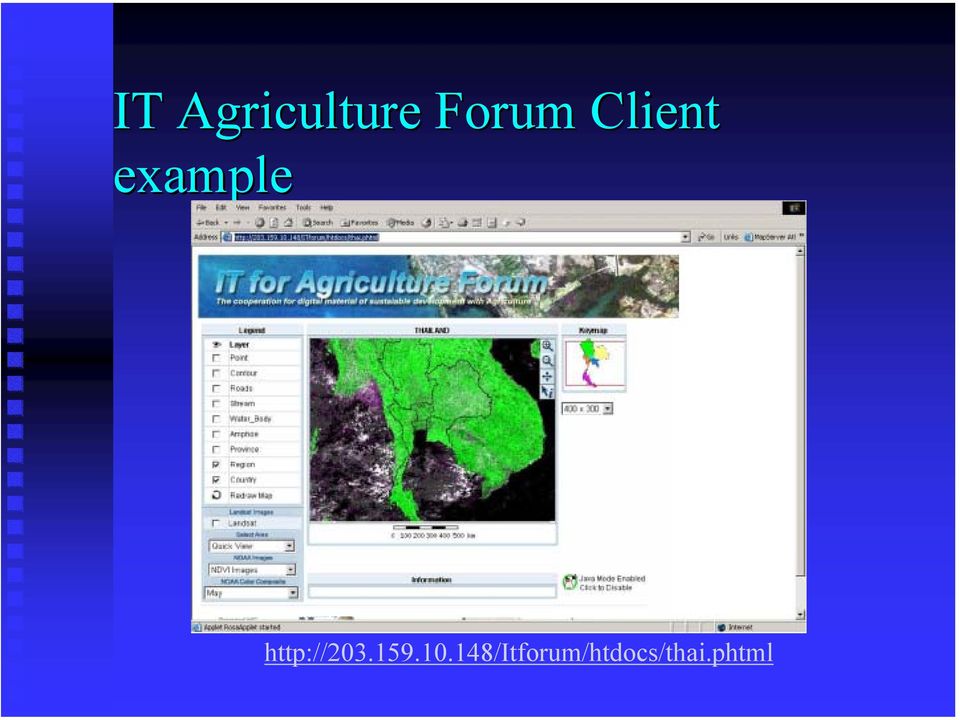
16 IT Agriculture Forum Client example
17 Asian Highway Database Development Participated by 31 Countries Asian Highway plays an important role in the Promotion and development of Int l l road transportation and cooperation Strengthening Int`l trade and Tourism More than 100,000km Under Multi-Natural environment and culture Diversity of Environment Asian Highway: Legacy of the silk road Utilize Various Information Road Alignment, Spec, Demographic Data Satellite Data + DEM MODIS, DMSP to Show Natural Environment along the routes

18 Conclusions Remote Sensing Image Server using Web Map Server has been developed Thailand LANDSAT mosaic is being served LANDSAT for GMS has been completed Two speed up mechanism has improved the access speed. Multiple server system was tested to serve RS images for other organization s s WMS as background. Looking for partners who would like to use our images as background of their own GIS data.

19 Thank you..

Setup a connection to RS Image Server using WMS MapBrowser
 Training Module Section V Setup a connection to RS Image Server using WMS MapBrowser 1. Introduction Maplab MapBrowser application is a spatial data discovery tool that is a compliant with OGC Web Mapping
Figure 2: System Flow Diagram for Workflow Management
 5. WORKFLOW MANAGEMENT The developed system EASKB uses the open source content management system called Drupal ([2]). A Content Management System - CMS is a tool that enables many user friendly features
Big Data Volume & velocity data management with ERDAS APOLLO. Alain Kabamba Hexagon Geospatial
 Big Data Volume & velocity data management with ERDAS APOLLO Alain Kabamba Hexagon Geospatial Intergraph is Part of the Hexagon Family Hexagon is dedicated to delivering actionable information through
Institute of Computational Modeling SB RAS
 Institute of Computational Modeling SB RAS ORGANIZATION OF ACCESS TO OBSERVATIONAL DATA USING WEB SERVICES FOR MONITORING SYSTEMS THE STATE OF THE ENVIRONMENT Kadochnikov Aleksey A. Russia, Krasnoyarsk
Oklahoma s Open Source Spatial Data Clearinghouse: OKMaps
 Oklahoma s Open Source Spatial Data Clearinghouse: OKMaps Presented by: Mike Sharp State Geographic Information Coordinator Oklahoma Office of Geographic Information MAGIC 2014 Symposium April 28-May1,
REMOTE SENSING AND GIS ACTIVITIES IN ASIAN INSTITUTE OF TECHNOLOGY: EDUCATION, TRAINING AND RESEARCH
 Back REMOTE SENSING AND GIS ACTIVITIES IN ASIAN INSTITUTE OF TECHNOLOGY: EDUCATION, TRAINING AND RESEARCH Kiyoshi Honda Space Technology Applications and Research (STAR) Program Asian Institute of Technology,
AN OPENGIS WEB MAP SERVER FOR THE ESA MULTI-MISSION CATALOGUE
 AN OPENGIS WEB MAP SERVER FOR THE ESA MULTI-MISSION CATALOGUE T. Westin a, *, C. Caspar b, L. Edgardh a, L. Schylberg c a Spacemetric AB, Tingsv 19, 19161 Sollentuna, Sweden - [email protected] b ESA Esrin,
 Development tools to create Web-GIS applications DbMAP ASJ the best solution to easily publish GIS data from existing spatial databases and distributed GIS data sources Easily designs, produces, and publishes
TerraAmazon - The Amazon Deforestation Monitoring System - Karine Reis Ferreira
 TerraAmazon - The Amazon Deforestation Monitoring System - Karine Reis Ferreira GEOSS Users & Architecture Workshop XXIV: Water Security & Governance - Accra Ghana / October 2008 INPE National Institute
BLACKBRIDGE SATELLITE IMAGERY THROUGH CLOUD COMPUTING
 BLACKBRIDGE SATELLITE IMAGERY THROUGH CLOUD COMPUTING Jason Setzer Cloud Product Manager Slide 1 THE RAPID EYE CONSTELLATION 5 Identical Satellites in same obit Up to 5 million km² collected daily 1 billion
UK Location Programme
 Location Information Interoperability Board Data Publisher How To Guide Understand the background to establishing an INSPIRE View Service using GeoServer DOCUMENT CONTROL Change Summary Version Date Author/Editor
Open Source GIS The Future?
 Open Source GIS The Future? Daniel Morissette DM Solutions Group Inc. Open Source Licensing No licensing costs Unlimited rights to: Use the software View and analyse the source Copy, reuse in other systems
FME 2007 Release Giving Raster the Vector Treatment. By Mary Jo Wagner
 FME 2007 Release Giving Raster the Vector Treatment By Mary Jo Wagner Giving Raster the Vector Treatment By Mary Jo Wagner Spatial extract, transform and load (ETL) tools such as Safe Software s FME have
DISMAR implementing an OpenGIS compliant Marine Information Management System
 DISMAR implementing an OpenGIS compliant Marine Information Management System Éamonn Ó T uama, Coastal & Marine Resources Centre, ERI, University College Cork. DISMAR DISMAR (Data Integration System for
Jozef Matula. Visualisation Team Leader IBL Software Engineering. 13 th ECMWF MetOps Workshop, 31 th Oct - 4 th Nov 2011, Reading, United Kingdom
 Visual Weather web services Jozef Matula Visualisation Team Leader IBL Software Engineering Outline Visual Weather in a nutshell. Path from Visual Weather (as meteorological workstation) to Web Server
CLOUD BASED N-DIMENSIONAL WEATHER FORECAST VISUALIZATION TOOL WITH IMAGE ANALYSIS CAPABILITIES
 CLOUD BASED N-DIMENSIONAL WEATHER FORECAST VISUALIZATION TOOL WITH IMAGE ANALYSIS CAPABILITIES M. Laka-Iñurrategi a, I. Alberdi a, K. Alonso b, M. Quartulli a a Vicomteh-IK4, Mikeletegi pasealekua 57,
Agile Retrieval of Big Data with. EarthServer. ECMWF Visualization Week, Reading, 2015-sep-29
 Agile Retrieval of Big Data with EarthServer ECMWF Visualization Week, Reading, 2015-sep-29 Peter Baumann Jacobs University rasdaman GmbH [email protected] [co-funded by EU through EarthServer, PublicaMundi]
An Introduction to Open Source Geospatial Tools
 An Introduction to Open Source Geospatial Tools by Tyler Mitchell, author of Web Mapping Illustrated GRSS would like to thank Mr. Mitchell for this tutorial. Geospatial technologies come in many forms,
Server GIS. What Server GIS software do we provide?
 Server GIS Distribute maps, models, and tools via the Web in a way that fits well into your workflows. SuperGeo offers numerous Server GIS solutions to fulfill the demands of corporate Intranets and the
Application Development Using Image Services Web APIs. Hong Xu, Wenxue Ju
 Application Development Using Image Services Web APIs Hong Xu, Wenxue Ju Session Outline Discuss and demonstrate the following image service web application patterns: Display image service in your web
Database-driven web mapping using jquery, PHP, PostgreSQL & SDE
 Database-driven web mapping using jquery, PHP, PostgreSQL & SDE By, Jon Nordling, Michael Humber Inbal Becker-Reshef, Brian Barker, Katie McGaughey, Chris Justice University of Maryland College Park http://geoglam-crop-monitor.org/
Vulnerability assessment of ecosystem services for climate change impacts and adaptation (VACCIA)
") Vulnerability assessment of ecosystem services for climate change impacts and adaptation (VACCIA) Action 2: Derivation of GMES-related remote sensing data Deliverable 1: Time-series of Earth Observation
Vulnerability assessment of ecosystem services for climate change impacts and adaptation (VACCIA) Action 2: Derivation of GMES-related remote sensing data Deliverable 1: Time-series of Earth Observation
Version 3.0, April 16, 2012, updated for ArcGIS 10.0 Produced by the Geographic Information Network of Alaska http://www.gina.alaska.
 Using the AlaskaMapped Web Services in ESRI ArcGIS Version 3.0, April 16, 2012, updated for ArcGIS 10.0 Produced by the Geographic Information Network of Alaska http://www.gina.alaska.edu AlaskaMapped
Multi-Temporal Wild Fire Monitoring in Lao PDR using MODIS Data
 Multi-Temporal Wild Fire Monitoring in Lao PDR using MODIS Data Vivarad Phonekeo Ph. D. Geoinformatics Center (GIC) Asian Institute of Technology [email protected], [email protected] www.vivarad.info Thatheva
ArcGIS. Image Server tutorial
 ArcGIS 9 ArcGIS Image Server tutorial Copyright 2006, 2007, and 2008 Zanja Technologies, Inc. All rights reserved. The information contained in this work is the property of Zanja Technologies, Inc., under
The USGS Landsat Big Data Challenge
 The USGS Landsat Big Data Challenge Brian Sauer Engineering and Development USGS EROS [email protected] U.S. Department of the Interior U.S. Geological Survey USGS EROS and Landsat 2 Data Utility and Exploitation
Cloud-based Geospatial Data services and analysis
 Cloud-based Geospatial Data services and analysis Xuezhi Wang Scientific Data Center Computer Network Information Center Chinese Academy of Sciences 2014-08-25 Outlines 1 Introduction of Geospatial Data
GIS AS A DECISION SUPPORT FOR SUPPLY CHAIN MANAGEMENT
 Paper Reference No.: PN-253 GIS AS A DECISION SUPPORT FOR SUPPLY CHAIN MANAGEMENT Sanjay Kumar 1 and Suneeta Agrawal 2 1. M. Tech. (GIS & Remote Sensing); GIS Cell; MNNIT, Allahabad, India (E-mail: [email protected])
The ORIENTGATE data platform
 Seminar on Proposed and Revised set of indicators June 4-5, 2014 - Belgrade (Serbia) The ORIENTGATE data platform WP2, Action 2.4 Alessandra Nuzzo, Sandro Fiore, Giovanni Aloisio Scientific Computing and
INSPIRE in practice: Experiences with INSPIRE data and services
 INSPIRE in practice: Experiences with INSPIRE data and services Peter Parslow Principal Geographic Information Architect June 2014: ISO TC211 Standards in Practice workshop What s INSPIRE? European Commission
Web and Mobile GIS Applications Development
 Web and Mobile GIS Applications Development Presented by : Aamir Ali Manager Section Head (GIS Software Customization) Pakistan Space and Upper Atmosphere Research Commission (SUPARCO) Geographical Information
Implementation of information system to respond to a nuclear emergency affecting agriculture and food products - Case of Morocco
 Centre National de l énergie des sciences et techniques nucléaires (CNESTEN-Morocco) Implementation of information system to respond to a nuclear emergency affecting agriculture and food products - Case
Open Source Visualisation with ADAGUC Web Map Services
 Open Source Visualisation with ADAGUC Web Map Services Maarten Plieger Ernst de Vreede John van de Vegte, Wim Som de Cerff, Raymond Sluiter, Ian van der Neut, Jan Willem Noteboom 1 ADAGUC project Cooperative
OPEN STANDARD WEB SERVICES FOR VISUALISATION OF TIME SERIES DATA OF FLOOD MODELS
 OPEN STANDARD WEB SERVICES FOR VISUALISATION OF TIME SERIES DATA OF FLOOD MODELS Barend Köbben FRMRC RPA 7 Workshop visualisations and flow simulations as flood risk communication tools
DEVELOPMENT OF WEB-BASED GIS INTERFACES FOR APPLICATION OF THE WEPP MODEL
 DEVELOPMENT OF WEB-BASED GIS INTERFACES FOR APPLICATION OF THE WEPP MODEL D.C. Flanagan A, J.R. Frankenberger A, C.S. Renschler B and B.A. Engel C A National Soil Erosion Research Laboratory, USDA-ARS,
INTEROPERABLE IMAGE DATA ACCESS THROUGH ARCGIS SERVER
 INTEROPERABLE IMAGE DATA ACCESS THROUGH ARCGIS SERVER Qian Liu Environmental Systems Research Institute 380 New York Street Redlands, CA92373, U.S.A - [email protected] KEY WORDS: OGC, Standard, Interoperability,
Review for Introduction to Remote Sensing: Science Concepts and Technology
 Review for Introduction to Remote Sensing: Science Concepts and Technology Ann Johnson Associate Director [email protected] Funded by National Science Foundation Advanced Technological Education program [DUE
J9.6 GIS TOOLS FOR VISUALIZATION AND ANALYSIS OF NEXRAD RADAR (WSR-88D) ARCHIVED DATA AT THE NATIONAL CLIMATIC DATA CENTER
 ARCHIVED DATA AT THE NATIONAL CLIMATIC DATA CENTER") J9.6 GIS TOOLS FOR VISUALIZATION AND ANALYSIS OF RADAR (WSR-88D) ARCHIVED DATA AT THE NATIONAL CLIMATIC DATA CENTER Steve Ansari * STG Incorporated, Asheville, North Carolina Stephen Del Greco NOAA National
J9.6 GIS TOOLS FOR VISUALIZATION AND ANALYSIS OF RADAR (WSR-88D) ARCHIVED DATA AT THE NATIONAL CLIMATIC DATA CENTER Steve Ansari * STG Incorporated, Asheville, North Carolina Stephen Del Greco NOAA National
CS5331 Web Security - Assignment 0
 CS5331 Web Security - Assignment 0 Due : 25 Jan 2016 1 Background The objective of this assignment is to give you a hands-on experience of setting up a virtual machine. This is an INDIVIDUAL assignment
SuperGIS Server 3.2 Standard Edition Specification
 SuperGIS Server 3.2 Standard Edition Specification 20140826 Specification 1. All of the services support SOAP (Simple Object Access Protocol). 2. Use map file created by SuperGIS Desktop as map services
System requirements. Java SE Runtime Environment(JRE) 7 (32bit) Java SE Runtime Environment(JRE) 6 (64bit) Java SE Runtime Environment(JRE) 7 (64bit)
 7 (32bit) Java SE Runtime Environment(JRE) 6 (64bit) Java SE Runtime Environment(JRE) 7 (64bit)") Hitachi Solutions Geographical Information System Client Below conditions are system requirements for Hitachi Solutions Geographical Information System Client. 1/5 Hitachi Solutions Geographical Information
Hitachi Solutions Geographical Information System Client Below conditions are system requirements for Hitachi Solutions Geographical Information System Client. 1/5 Hitachi Solutions Geographical Information
Australia s National Carbon Accounting System. Dr Gary Richards Director and Principal Scientist
 Australia s National Carbon Accounting System Dr Gary Richards Director and Principal Scientist Government Commitment The Australian Government has committed to a 10 year, 3 phase, ~$35M program for a
A Hybrid Architecture for Mobile Geographical Data Acquisition and Validation Systems
 A Hybrid Architecture for Mobile Geographical Data Acquisition and Validation Systems Claudio Henrique Bogossian 1, Karine Reis Ferreira 1, Antônio Miguel Vieira Monteiro 1, Lúbia Vinhas 1 1 DPI Instituto
Applied ERDAS Solutions
 V Konferencja naukowo-techniczna ZASTOSOWANIA TECHNIK OBSERWACJI ZIEMI X Konferencja użytkowników oprogramowania ERDAS Inc. Applied ERDAS Solutions Examples of different vertical market segments Irmi Runkel,
Managing a Geographic Database From Mobile Devices Through OGC Web Services
 Managing a Geographic Database From Mobile Devices Through OGC Web Services Nieves R. Brisaboa 1, Miguel R. Luaces 1, Jose R. Parama 1, and Jose R. Viqueira 2 1 Database Laboratory, University of A Coruña,
VISUAL INSPECTION OF EO DATA AND PRODUCTS - OVERVIEW
 WMS services from the EUMETSAT real-time Image Gallery Uwe Voges (1), Michael Schick (2), Udo Einspanier (1) (1) con terra GmbH Martin-Luther-King-Weg 24, 48155, Münster, Germany EMail: (U.Voges U.Einspanier)@conterra.de
On the Efficient Evaluation of Array Joins
 [co-funded by EU through H2020 EarthServer -2] On the Efficient Evaluation of Array Joins Big Data in the Geosciences Workshop IEEE Big Data, Santa Clara, US, 2015-oct-29 Peter Baumann, Vlad Merticariu
GeoPackage, The Shapefile Of The Future
 FOSS4G 2013 GeoPackage, The Shapefile Of The Future @PirminKalberer Sourcepole AG, Switzerland www.sourcepole.com About Sourcepole > QGIS > Core dev. & Project Steering Commitee > QGIS Server, Printing,
Solution for private cloud computing
 The CC1 system Solution for private cloud computing 1 Outline What is CC1? Features Technical details Use cases By scientist By HEP experiment System requirements and installation How to get it? 2 What
Pennsylvania Geospatial Data Sharing Standards (PGDSS) V 2.5
 V 2.5") Submitted to: Pennsylvania Geospatial Data Sharing Standards (PGDSS) V 2.5 Spatial Data Migration Tools Report May 2, 2007 Table of Contents 1.0 Document Purpose...B-1 2.0 Overview of Spatial Data Migration
Submitted to: Pennsylvania Geospatial Data Sharing Standards (PGDSS) V 2.5 Spatial Data Migration Tools Report May 2, 2007 Table of Contents 1.0 Document Purpose...B-1 2.0 Overview of Spatial Data Migration
GEO 425, Spring 2012 LAB 3: Introduction to Web Map Services
 GEO 425, Spring 2012 LAB 3: Introduction to Web Map Services Objectives: If you have your own web server, it's great to be able to host your own geospatial data. That data can then be accessed through
The NASA NEESPI Data Portal to Support Studies of Climate and Environmental Changes in Non-boreal Europe
 The NASA NEESPI Data Portal to Support Studies of Climate and Environmental Changes in Non-boreal Europe Suhung Shen NASA Goddard Space Flight Center/George Mason University Gregory Leptoukh, Tatiana Loboda,
Choosing the right GIS framework for an informed Enterprise Web GIS Solution
 13 ANNUAL INTERNATIONAL CONFERENCE AND EXHIBITION ON GEOSPATIAL INFORMATION TECHNOLOGY AND APPLICATIONS Epicentre; Gurgaon, India; 19-21 January, 2010 Choosing the right GIS framework for an informed Enterprise
IDL. Get the answers you need from your data. IDL
 Get the answers you need from your data. IDL is the preferred computing environment for understanding complex data through interactive visualization and analysis. IDL Powerful visualization. Interactive
Monitoring Global Crop Condition Indicators Using a Web-Based Visualization Tool
 Monitoring Global Crop Condition Indicators Using a Web-Based Visualization Tool Bob Tetrault, Regional Commodity Analyst, and Bob Baldwin, GIS Specialist, USDA, Foreign Agricultural Service, Washington,
A remote sensing instrument collects information about an object or phenomenon within the
 Satellite Remote Sensing GE 4150- Natural Hazards Some slides taken from Ann Maclean: Introduction to Digital Image Processing Remote Sensing the art, science, and technology of obtaining reliable information
Creating a GIS based learning tool for the Faculty of Forest & Environment at the HNE Eberswalde
 Creating a GIS based learning tool for the Faculty of Forest & Environment at the HNE Eberswalde G. Singelnstein / H. Plesse University of Applied Sciences in Eberswalde 14.04.2011 Introduction I What
TerraColor White Paper
 TerraColor White Paper TerraColor is a simulated true color digital earth imagery product developed by Earthstar Geographics LLC. This product was built from imagery captured by the US Landsat 7 (ETM+)
EUMETSAT EO Portal. End User Image Access using OGC WMS/WCS services. EUM/OPS/VWG/10/0095 Issue <1> <14/01/2010> Slide: 1
 EUMETSAT EO Portal End User Image Access using OGC WMS/WCS services Slide: 1 Overview Introduction: status of data access and visualization EUMETSAT datasets Architecture Web Map Service implementation
Digital image processing
 746A27 Remote Sensing and GIS Lecture 4 Digital image processing Chandan Roy Guest Lecturer Department of Computer and Information Science Linköping University Digital Image Processing Most of the common
 Integrated Data Viewer (IDV) a visualization framework Yuan Ho Unidata Program Center Boulder, CO Presentation Outline Integrated Data Viewer (IDV) overview The IDV features IDV examples and customized
Enabling embedded maps
 Enabling embedded maps Case: National geoportal of Finland Antti Rainio National Land Survey of Finland Trends: Web Services, Mapping Mashup, Open Source, Open Data Decentralised data s Service interfaces
County of Los Angeles. Chief Information Office Preferred Technologies for Geographic Information Systems (GIS) September 2014
 September 2014") County of Los Angeles Chief Information Office Preferred Technologies for Geographic Information Systems (GIS) September 2014 CIO Preferred Technologies for GIS This document lists the preferred Geographic
County of Los Angeles Chief Information Office Preferred Technologies for Geographic Information Systems (GIS) September 2014 CIO Preferred Technologies for GIS This document lists the preferred Geographic
DEVELOPMENT OF A WEB GEOSERVICES PLATFORM FOR SCHOOL OF ENVIRONMENTAL SCIENCES, MAHATMA GANDHI UNIVERSITY, KERALA, INDIA
 DEVELOPMENT OF A WEB GEOSERVICES PLATFORM FOR SCHOOL OF ENVIRONMENTAL SCIENCES, MAHATMA GANDHI UNIVERSITY, KERALA, INDIA Sumith Satheendran S. 1, John C. M. 1, Fasalul Faseeh K. 1 and Aanisa K. M. 1,2
ERDAS IMAGINE The world s most widely-used remote sensing software package
 ERDAS IMAGINE The world s most widely-used remote sensing software package ERDAS IMAGINE Geographic imaging professionals need to process vast amounts of geospatial data every day often relying on software
ArcGIS. Server. A Complete and Integrated Server GIS
 ArcGIS Server A Complete and Integrated Server GIS ArcGIS Server A Complete and Integrated Server GIS ArcGIS Server enables you to distribute maps, models, and tools to others within your organization
Version 1.6. MDweb installation and configuration (scripts databases) Linux Platform. 1.3 Authors: Jean Christophe Desconnets (jcd@teledetection.
 Linux Platform. 1.3 Authors: Jean Christophe Desconnets (jcd@teledetection.") Version 1.6 MDweb installation and configuration (scripts databases) Linux Platform Version Comments 1 Authors : Jean Christophe Desconnets ([email protected]) Translation : Kim Agrawal ([email protected])
Version 1.6 MDweb installation and configuration (scripts databases) Linux Platform Version Comments 1 Authors : Jean Christophe Desconnets ([email protected]) Translation : Kim Agrawal ([email protected])
G-Cloud Service Definition Cadcorp Web Map Layers
 G-Cloud Service Definition Cadcorp Web Map Layers Ref: RM1557/iii Government Procurement Services G-Cloud III Contents 1. Introduction... 3 2. Service Overview... 4 2.1 Web Map Layers... 4 2.2 Initial
GIS Initiative: Developing an atmospheric data model for GIS. Olga Wilhelmi (ESIG), Jennifer Boehnert (RAP/ESIG) and Terri Betancourt (RAP)
, Jennifer Boehnert (RAP/ESIG) and Terri Betancourt (RAP)") GIS Initiative: Developing an atmospheric data model for GIS Olga Wilhelmi (ESIG), Jennifer Boehnert (RAP/ESIG) and Terri Betancourt (RAP) Unidata seminar August 30, 2004 Presentation Outline Overview
GIS Initiative: Developing an atmospheric data model for GIS Olga Wilhelmi (ESIG), Jennifer Boehnert (RAP/ESIG) and Terri Betancourt (RAP) Unidata seminar August 30, 2004 Presentation Outline Overview
Assessing Hurricane Katrina Damage to the Mississippi Gulf Coast Using IKONOS Imagery
 Assessing Hurricane Katrina Damage to the Mississippi Gulf Coast Using IKONOS Imagery Joseph P. Spruce Science Systems and Applications, Inc. John C., MS 39529 Rodney McKellip NASA Project Integration
Introduction to the Mapbender OWS Security Proxy
 Introduction to the Mapbender OWS Security Proxy Arnulf Christl, WhereGroup GmbH & Co. KG, Bonn, Germany 1/16 Agenda 1 Introduction to the Architecture OWS from Bottom Up with the OSGeo SDI Software Stack
Intergraph Geospatial Portfolio 2013
 W H A T S N E W? Intergraph Geospatial Portfolio 2013 Photogrammetry LPS ImageStation Remote Sensing ERDAS IMAGINE GIS GeoMedia Server GeoMedia WebMap GeoMedia Smart Client ERDAS APOLLO Geospatial SDI
Data interchange between Web client based task controllers and management information systems using ISO and OGC standards
 Data interchange between Web client based task controllers and management information systems using ISO and OGC standards Michael Nørremark 1*, Ole Jørgensen 1, Jens Bligaard 2 and Claus G. Sørensen 1
CentropeSTATISTICS a Tool for Cross-Border Data Presentation Manfred Schrenk, Clemens Beyer, Norbert Ströbinger
 Manfred Schrenk, Clemens Beyer, Norbert Ströbinger (Dipl.-Ing. Manfred Schrenk, Multimediaplan.at, 2320 Schwechat, Austria, [email protected]) (Dipl.-Ing. Clemens Beyer, CORP Competence Center
Design Requirements for an AJAX and Web-Service Based Generic Internet GIS Client
 11th AGILE International Conference on Geographic Information Science 2008 Page 1 of 6 Design Requirements for an AJAX and Web-Service Based Generic Internet GIS Client Edward Nash 1, Peter Korduan 1,
Open Source Geospatial Software. Bob Bruce, P.Eng Mapping and Lands Branch, Manitoba Conservation WWW.HWPS.CA [email protected]
 A Survey of Open Source Geospatial Software Bob Bruce, P.Eng Mapping and Lands Branch, Manitoba Conservation WWW.HWPS.CA [email protected] APEGM PD Breakfast Tuesday, 12 June 2007 access this presentation
Healthcare Information System A Web Based Spatial and Aspatial Helpdesk
 Vol.3, Issue.1, Jan-Feb. 2013 pp-218-224 ISSN: 2249-6645 Healthcare Information System A Web Based Spatial and Aspatial Helpdesk Shoba P M Tech Geo-Informatics, University of Madras, India ABSTRACT: Healthcare
OSGeo Web Mapping Typification: GeoMajas, Mapbender, MapFish and OpenLayers. Christoph Baudson Arnulf Christl FOSS4G 2010 Barcelona
 OSGeo Web Mapping Typification: GeoMajas, Mapbender, MapFish and OpenLayers Christoph Baudson Arnulf Christl FOSS4G 2010 Barcelona Disclaimer All information contained in this presentation has been compiled
Application of cloud based sensor data infrastructure for agricultural information service in Hokkaido Japan
 Application of cloud based sensor data infrastructure for agricultural information service in Hokkaido Japan APAN 36th Meeting 20 Aug 2014 HONDA Kiyoshi: Chubu University Apichon Witayangkurn: University
Five Steps to Better Performance
 Effective Web maps have a specific focus and are designed so users can interact with them to accomplish meaningful tasks. Five Steps to Better Performance Sample methodology for creating a great Web map
DataTube: web services voor data
 DataTube: web services voor data Gerben de Boer Onno van de Akker Gerrit Hendriksen Deltares, Matroos Deltares, FEWS Deltares, NHI FEWS & Matroos: database > viewers VIEWER client 3 rd party viewer Matroos
Remote Sensing Department Iranian Space Agency Jeiran Amiraslani 6th June 2014
 Role of E Learning in Knowledge Promotion and Capacity Building for Monitoring and Assessment of Natural Disasters: A case study for Drought Monitoring Remote Sensing Department Iranian Space Agency Jeiran
Lecture 2. Internet: who talks with whom?
 Lecture 2. Internet: who talks with whom? An application layer view, with particular attention to the World Wide Web Basic scenario Internet Client (local PC) Server (remote host) Client wants to retrieve
D3.4.1: Data Fusion Tools
 COMPETITIVINESS AND INNOVATION FRAMEWORK PROGRAMME CIP-ICT-PSP-2013-7 Pilot Type B WP3 Service platform integration and deployment in cloud infrastructure D3.4.1: Data Fusion Tools Deliverable Lead: NETCAD
A Web Service based U.S. Cropland Visualization, Dissemination and Querying System
 A Web Service based U.S. Cropland Visualization, Dissemination and Querying System Rick Mueller, Zhengwei Yang, and Dave Johnson USDA/National Agricultural Statistics Service Weiguo Han and Liping Di GMU/Center
M6422A Implementing and Managing Windows Server 2008 Hyper-V
 M6422A Implementing and Managing Windows Server 2008 Hyper-V Looking at Training Differently... Course 6422A: Implementing and Managing Windows Server 2008 Hyper-V Length: Published: Language(s): Audience(s):
Implementing a Web-based Transportation Data Management System
 Presentation for the ITE District 6 Annual Meeting, June 2006, Honolulu 1 Implementing a Web-based Transportation Data Management System Tim Welch 1, Kristin Tufte 2, Ransford S. McCourt 3, Robert L. Bertini
GIS Beyond the Basics: Web Maps and File Sharing Services
 GIS Beyond the Basics: Web Maps and File Sharing Services by Julie Coco, PE I. INTRODUCING WEB-BASED GIS SERVICES A GIS service, or Geoservice, provides a way to retrieve maps, images, or geoprocessing