FOREST PLANNING SOFTWARE DEVELOPMENT IN NORWAY
|
|
|
- Erik Newton
- 10 years ago
- Views:
Transcription
1 FOREST PLANNING SOFTWARE DEVELOPMENT IN NORWAY Terje Gobakken & Tron Eid Helsinki, 09. March 2006 Department of Ecology and Natural Resource Management

2 INTRODUCTION = New pilot project = SGIS biological models economic calculations simulation, optimization and GIS features Case

3 PILOT PROJECT ORGANIZATION = Aim : Develop a research and end use strategy for new generations of decision support systems for forest management planning in Norway = External partners and founders: Prevista and Norskog = Time schedule: year 2006, 4 labour months = Cooperation Finland and Sweden = Seminar (June): Researchers and users = Expected output: Report: state of art and future research priorities Application to the Research Council

4 SGIS IS A TOOL FOR: 1. Simulation of forest development 2. Optimization of forest treatments in a GIS user interface!

5 BACKGROUND = This version of SGIS is based on a prototype developed in PC ArcInfo (Næsset 1997). = This version of SGIS is based on ArcView version 8 (9) and is programmed in Visual Basic for Applications. = SGIS consist of a functionality specially made for forest related problems and standard ArcView GIS functionality = SGIS is mainly used for teaching and research at the university. However, SGIS is being commercialized at the moment.

6 3 PARTS: GAYA stand simulator J mathematical programming tool GAYA and J is hidden behind SGIS windows GIS applikasjon (ArcView)

7 GAYA A simulation tool to describe silvicultural regimes! Forest treatments models = Developed by prof. Eriksson at the Swedish University of Agricultural Sciences in 1983 = Translated to Norwegian conditions by Hoen & Eid ( ) = Since 1990 further upgraded and developed. (Ex.: C in wood products and forest soil) Calculations and book keeping for up to 20 periods of 5 or 10 years
 = Since 1990 further upgraded and developed. (Ex.")
8 SUB MODELS IN GAYA = Simulations are based on: 1. «mean tree» (d ba + h L ), and 2. number of stems (N ha 1 ) = Important functions: mean diameter growth (Blingsmo, 1984), height development (Tveite 1976,1977; Braastad, 1977), natural mortality (Eid & Øyen 2003) tree volume (Braastad 1966, Brantseg 1967 og Vestjordet 1967) timber prices (Blingsmo & Veidahl, 1992) harvesting and forwarding costs (Anon., 1994)
 timber prices (Blingsmo & Veidahl, 1992) harvesting")
9 GAYA: ASSUMPTIONS: = General: Interest rate Timber prices Harvest and cutting costs = Stand level: Wood quality Additional harvest and cutting costs Forwarding distance

10 GAYA: TREATMENT SCHEDULES = Example: stand i is 30 year. The stand can not be cut before the stand is 50 year Year

11 J SOFTWARE = A commercial software package for general linear programming (LP) package for solving forest management planning and conventional LP problems. = Developed by Dr. Juha Lappi at the Finnish Forest Research Institute (METLA), Finland, in
,")
12 LP = Objectives: Maximizations of net present value! Maximizations of standing volume! = Restrictions/constraints: Non declining harvest Non declining income Standing volume Old growth forest Dead wood Broadleaves The whole forest or smaller parts Protected area

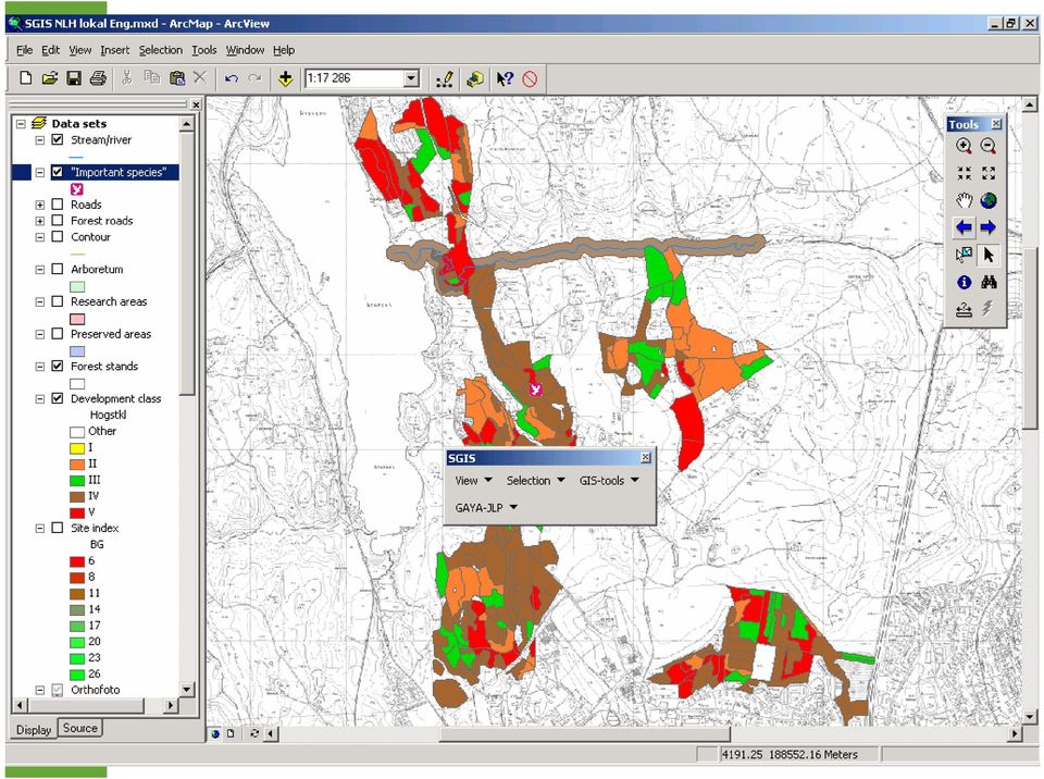
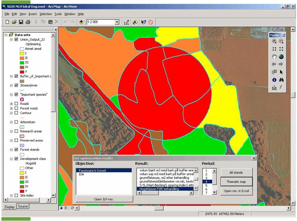
13 What is SGIS? = SGIS is an interface between a Geographical Information System and the long term forest management planning model, GAYA J. = From the SGIS graphical user interface a complete vector GIS is available, and in addition biological simulations and optimizations with GAYA J may be done. = Forecasted states for the next 100 years can be presented as tabular reports, figures or thematic maps.

14 Case study = Data from the forest at the Norwegian University of Life Sciences at Ås.

15 NORWEGIAN UNIVERSITY OF LIFE SCIENCES
16 Menu: GAYA J
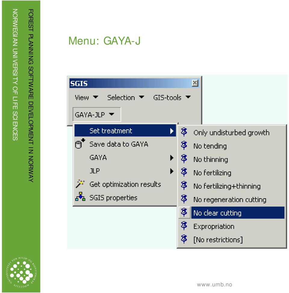
17 Menu: GAYA J

18 Hent optimeringsresultat!!!!
19 NORWEGIAN UNIVERSITY OF LIFE SCIENCES

20 ECONOMICAL RESULTS

21 Example of some previous studies with GAYA J/SGIS = Næsset, E A spatial decision support system for longterm forest management planning by means of linear programming and a geographical information system. Scand. J. For. Res. 12 (1): = Næsset, E., Gobakken, T. & Hoen, H.F Economic analysis of timber management practices promoting preservation of biological diversity. Scand. J. For. Res. 12 (3): = Eid, T., Hoen, H.F. & Økseter, P Timber production possibilities of Norwegian forest area and measures for a sustainable forestry. Forest Policy and Economics. In press.
DESCARTES & EFIMOD: An Integrated System for Simulation Modelling and Exploration Data Analysis for Decision Support in Sustainable Forestry
 DESCARTES & EFIMOD: An Integrated System for Simulation Modelling and Exploration Data Analysis for Decision Support in Sustainable Forestry A. Komarov a, O. Chertov b, G. Andrienko c, N. Andrienko c,
Nordic Trends in Forest Inventory, Management Planning and Modelling
 Nordic Trends in Forest Inventory, Management Planning and Modelling Proceedings of SNS Meeting in Solvalla, Finland April 17 19, 2001 Juha Heikkinen, Kari T. Korhonen, Markku Siitonen, Mikael Strandström
Transatlantic Masters Degree Program in Forest Resources (ATLANTIS)
") Faculty of Agriculture and Festry Transatlantic Masters Degree Program in Fest Resources (ATLANTIS) University of Helsinki, Department of Fest Sciences Transatlantic Masters Degree Program in Fest Resources
Faculty of Agriculture and Festry Transatlantic Masters Degree Program in Fest Resources (ATLANTIS) University of Helsinki, Department of Fest Sciences Transatlantic Masters Degree Program in Fest Resources
ASSESSING EFFECTS OF LASER POINT DENSITY ON BIOPHYSICAL STAND PROPERTIES DERIVED FROM AIRBORNE LASER SCANNER DATA IN MATURE FOREST
 ISPRS Workshop on Laser Scanning 2007 and SilviLaser 2007, Espoo, September 12-14, 2007, Finland ASSESSING EFFECTS OF LASER POINT DENSITY ON BIOPHYSICAL STAND PROPERTIES DERIVED FROM AIRBORNE LASER SCANNER
Lesson 9: Introduction to the Landscape Management System (LMS)
") Lesson 9: Introduction to the Landscape Management System (LMS) Review and Introduction In earlier lessons, you learned how to establish and take measurements in sample inventory plots. In Lesson 8, you
Lesson 9: Introduction to the Landscape Management System (LMS) Review and Introduction In earlier lessons, you learned how to establish and take measurements in sample inventory plots. In Lesson 8, you
Procedures for Factoring Visual Resources into Timber Supply Analyses
 Procedures for Factoring Visual Resources into Timber Supply Analyses March 17, 1998 Final Version 0 1.0 PURPOSE The purpose of these procedures is to enable visual resources, to be incorporated into the
Transatlantic Masters Degree Program in Forest Resources (ATLANTIS)
") Faculty of Agriculture and Festry Transatlantic Masters Degree Program in Fest Resources (ATLANTIS) University of Helsinki, Department of Fest Sciences Transatlantic Masters Degree Program in Fest Resources
Faculty of Agriculture and Festry Transatlantic Masters Degree Program in Fest Resources (ATLANTIS) University of Helsinki, Department of Fest Sciences Transatlantic Masters Degree Program in Fest Resources
Establishing ecologically sustainable forest biomass supply chains: A case study in the boreal forest of Canada
 Establishing ecologically sustainable forest biomass supply chains: A case study in the boreal forest of Canada Evelyne Thiffault Canadian Forest Service David Paré Canadian Forest Service Sylvain Volpé
Valuing Timber Resource Stocks in the Canadian Natural Resource Stock Accounts
 Valuing Timber Resource Stocks in the Canadian Natural Resource Stock Accounts London Group, November 2013 Environment Accounts and Statistics Division Statistics Canada October 18 th, 2013 Quick facts
GEOGRAPHIC INFORMATION SYSTEMS
 GEOGRAPHIC INFORMATION SYSTEMS WHAT IS A GEOGRAPHIC INFORMATION SYSTEM? A geographic information system (GIS) is a computer-based tool for mapping and analyzing spatial data. GIS technology integrates
Challenges in Forest Economics
 Challenges in Forest Economics Presentation at International Conference Current problems in forest economics Puszczykowo, Poland, June 7-9, 2011 Birger Solberg, Prof. Dr Norwegian University of Life Sciences
Forest Fire Research in Finland
 International Forest Fire News (IFFN) No. 30 (January June 2004, 22-28) Forest Fire Research in Finland Effective wildfire suppression and diminished use of prescribed burning in forestry has clearly eliminated
Technology For Adaptation. Forestry Conservation Management. Dr. Javier Aliaga Lordemann
 Technology For Adaptation. Forestry Conservation Management Dr. Javier Aliaga Lordemann Forests has more carbon store than the currently carbon free atmosphere. By contrast, are important sources of emissions
IMPLEMENTING ECOSYSTEM BASED INTEGRATED RESOURCE MANAGEMENT IN NOVA SCOTIA
 IMPLEMENTING ECOSYSTEM BASED INTEGRATED RESOURCE MANAGEMENT IN NOVA SCOTIA Bruce Stewart, Forest Ecologist, RPF, Peter Neily, Forest Ecologist, RPF Nova Scotia Department of Natural Resources, Truro, Nova
EFFECTS OF BENCHMARKING OF ELECTRICITY DISTRIBUTION COMPANIES IN NORDIC COUNTRIES COMPARISON BETWEEN DIFFERENT BENCHMARKING METHODS
 EFFECTS OF BENCHMARKING OF ELECTRICITY DISTRIBUTION COMPANIES IN NORDIC COUNTRIES COMPARISON BETWEEN DIFFERENT BENCHMARKING METHODS Honkapuro Samuli 1, Lassila Jukka, Viljainen Satu, Tahvanainen Kaisa,
TwoDog Forest Inventory Software. Complete Field to Office Forest Inventory Solution for Timber and Non-Timber Values
 TwoDog Forest Inventory Software Complete Field to Office Forest Inventory Solution for Timber and Non-Timber Values TwoDog Forest Inventory Software Complete Field to Office Forest Inventory Solution
Accelerated Master of Geographic Information Science. School of Forest Resources and Environmental Science
 Accelerated Master of Geographic Information Science School of Forest Resources and Environmental Science Contacts: Andrew J. Storer, Associate Dean Michael D. Hyslop, MGIS Coordinator Overview The accelerated
USE OF GIS AS A REAL TIME DECISION SUPPORT SYSTEM FOR IRRIGATION DISTRICTS. Gabriele Bonaiti, Ph.D. 1 Guy Fipps, Ph.D., P.E.
 USE OF GIS AS A REAL TIME DECISION SUPPORT SYSTEM FOR IRRIGATION DISTRICTS Gabriele Bonaiti, Ph.D. 1 Guy Fipps, Ph.D., P.E. 2 ABSTRACT GIS technology has been utilized in the past years by drainage and
KEY WORDS: Geoinformatics, Geoinformation technique, Remote Sensing, Information technique, Curriculum, Surveyor.
 CURRICULUM OF GEOINFORMATICS INTEGRATION OF REMOTE SENSING AND GEOGRAPHICAL INFORMATION TECHNOLOGY Kirsi VIRRANTAUS*, Henrik HAGGRÉN** Helsinki University of Technology, Finland Department of Surveying
Report from Life Coastal Woodlands. Forest management methods in the coastal woodlands
 Report from Life Coastal Woodlands Forest management methods in the coastal woodlands Ida Wigrup, Swedish Forest Agency 2007 Content 1 Introduction 3 2 Regeneration cutting with nature conservation consideration
A GIS helps you answer questions and solve problems by looking at your data in a way that is quickly understood and easily shared.
 A Geographic Information System (GIS) integrates hardware, software, and data for capturing, managing, analyzing, and displaying all forms of geographically referenced information. GIS allows us to view,
ArcGIS Data Models Practical Templates for Implementing GIS Projects
 ArcGIS Data Models Practical Templates for Implementing GIS Projects GIS Database Design According to C.J. Date (1995), database design deals with the logical representation of data in a database. The
CBU Master s Degree Programme in Forestry and Environmental Engineering. Degree requirements in Forest Ecology and Management 2011-2014
 Faculty of Agriculture and Forestry 1(6) Master s Degree Programme in Forestry and Environmental Engineering Degree requirements in Forest Ecology and Management 2011-2014 Participating Universities in
Logistics software implementation in Austrian forest and timber industries
 Logistics software implementation in Austrian forest and timber industries Peter Daxner University of Agricultural Sciences, Vienna Institute of Forest and Mountain Risk Engineering Peter-Jordan-Str. 70/2,
Assume you have 40 acres of forestland that was
 A l a b a m a A & M a n d A u b u r n U n i v e r s i t i e s ANR-1371 Basal Area: A Measure Made for Management Assume you have 40 acres of forestland that was recently assessed by a natural resource
Available study programs at Czech University of Life Sciences Prague
 EU subject code University subject Name of course/program Mobility Language Homepage 1,1 1,1 Environmental Engineering in Agriculture II Rural Communication and Extension 1,1 Tropical Forestry and Agroforestry
Norwegian Forests. Policy and Resources
 Norwegian Forests Policy and Resources 21 Forestry in Norway Norway has long traditions in forestry and forest management, and for using wood in construction and as a source of energy. Sawn wood and round
Application of airborne remote sensing for forest data collection
 Application of airborne remote sensing for forest data collection Gatis Erins, Foran Baltic The Foran SingleTree method based on a laser system developed by the Swedish Defense Research Agency is the first
Government 1009: Advanced Geographical Information Systems Workshop. LAB EXERCISE 3b: Network
 Government 1009: Advanced Geographical Information Systems Workshop LAB EXERCISE 3b: Network Objective: Using the Network Analyst in ArcGIS Implementing a network functionality as a model In this exercise,
IAS/IFRS forest accounting and valuation on profitability bookkeeping
 IAS/IFRS forest accounting and valuation on profitability bookkeeping farms Conference IUFRO Unit 4.05.00 Managerial Economics and Accounting 28 October 2009, Darmstadt, Germany Arto Latukka 1) Markku
Master s Degree Programme in Forest Sciences and Business (MScFB) 2014-2015
 2014-2015") Faculty of Agriculture and Forestry 1(11) Master s Degree Programme in Forest Sciences and Business (MScFB) 2014-2015 Degree requirements in Forest Ecology and Management, 120 cr Degree requirements in
Faculty of Agriculture and Forestry 1(11) Master s Degree Programme in Forest Sciences and Business (MScFB) 2014-2015 Degree requirements in Forest Ecology and Management, 120 cr Degree requirements in
Financial maturity is when the rate of value
 Cutting at Financial Maturity: Maximizing the economic return of your woodland Woodland owners harvest trees for financial and personal reasons. Deciding when is the optimal time to harvest is difficult
Department of Forest and
 Colorado State University 1 Department of Forest and Rangeland Stewardship Office in Forestry Building, Room 123 (970) 491-6911 warnercnr.colostate.edu/frs-home (http://warnercnr.colostate.edu/ frws-home)
Sensitive soil harvesting - research activities at FFRI
 Sensitive soil harvesting - research activities at FFRI Research on several programmes: Production forestry in drained peatlands (Jori Uusitalo et al.): machinery, methods for bearing capacity predicting,
Introduction to ArcView 3.2a
 Introduction to ArcView 3.2a Training Center U.S. Geological Survey Center for Earth Resources Observation and Science (EROS) Sioux Falls, South Dakota, USA Introduction to ArcView 3.2a Introduction to
GIS Solutions for FTTx Design. David Nelson, GISP
 GIS Solutions for FTTx Design David Nelson, GISP Telecom GIS Manager, Black & Veatch Agenda Intro to GIS Telecom GIS Vision GIS Strategy Project Execution Mobile Online Services Dashboards Client Deliverables
Using resources in an efficient way Case Metsä Group
 EN(14)4468:1 Using resources in an efficient way Case Tytti Peltonen Copa Cogeca workshop on Circular Economy 4.6.2014 1 sustainably from the forest Sales EUR 4.9 billion; personnel 11,000 Production units
Changes of coniferous timber and tree lines in Finnish Lapland during 1983-2009
 Workshop Silviculture in Changing Environment November 24-25, 2014 Kirkkonummi, Finland Changes of coniferous timber and tree lines in Finnish Lapland during 1983-2009 Anna Franke, Pasi Aatsinki, Ville
A quick overview of geographic information systems (GIS) Uwe Deichmann, DECRG <[email protected]>
 Uwe Deichmann, DECRG <udeichmann@worldbank.org>") A quick overview of geographic information systems (GIS) Uwe Deichmann, DECRG Why is GIS important? A very large share of all types of information has a spatial component ( 80
A quick overview of geographic information systems (GIS) Uwe Deichmann, DECRG Why is GIS important? A very large share of all types of information has a spatial component ( 80
Comparison of Logging Residue from Lump Sum and Log Scale Timber Sales James O. Howard and Donald J. DeMars
 United States Department of Agriculture Forest Service Pacific Northwest Forest and Range Experiment Station Research Paper PNW-337 May 1985 Comparison of Logging Residue from Lump Sum and Log Scale Timber
IAS/IFRS Accounting and Forest Valuation on Farm Forestry
 IAS/IFRS Accounting and Forest Valuation on Farm Forestry FIGURES FOR FORESTS International Workshop Freiburg, Germany, 25.11.2008 Markku Penttinen 1), Arto Latukka 2) & Olli Rantala 2) 1) Finnish Forest
Distributed Data Management in Internet Map Services
 Distributed Data Management in Internet Map Services Experiences from Lounaispaikka Thematic Atlas Antti Vasanen Regional Council of Southwest Finland Lounaispaikka Lounaispaikka is a regional non-profit
Forestry Thematic Exploitation Platform Earth Observation Open Science 2.0
 Forestry Thematic Exploitation Platform Earth Observation Open Science 2.0 Tuomas Häme VTT Technical Research of Finland Ltd and the Forestry TEP Team Objective One-stop shop for forestry remote sensing
Community Tree Inventory: Data Collection
 USDA FOREST SERVICE NORTHEAST CENTER FOR URBAN & COMMUNITY FORESTRY www.umass.edu/urbantree Community Tree Inventory: Data Collection An Introduction - July 2002 United States Department of Agriculture
MINNESOTA DEPARTMENT OF NATURAL RESOURCES. Division of Forestry
 MINNESOTA DEPARTMENT OF NATURAL RESOURCES Division of Forestry Other major programs: Private Forest Management Urban and Community Forestry Insect and Disease Management Urban and Community Forestry
Student who have less then 60% marks in highest degree have to pass entrance exam
 EU of Student who have less then 60% marks in highest degree have to pass entrance exam RIGA GRADUATE SCHOOL OF LAW Address: Strēlnieku iela 4k-2 Riga LV-1010, E-mail: [email protected] Phone: +371 67039206
Testing steady states carbon stocks of Yasso07 and ROMUL models against soil inventory data in Finland
 Testing steady states carbon stocks of Yasso07 and ROMUL models against soil inventory data in Finland A. Lehtonen 1, T. Linkosalo 2, J. Heikkinen 1, M. Peltoniemi 1, R. Sievänen 1, R. Mäkipää 1, P. Tamminen
Use of numerical weather forecast predictions in soil moisture modelling
 Use of numerical weather forecast predictions in soil moisture modelling Ari Venäläinen Finnish Meteorological Institute Meteorological research [email protected] OBJECTIVE The weather forecast models
Forest Inventory Strategic Plan
 February 2013 Ministry of Forests, Lands and Natural Resource Operations Forest Inventory Strategic Plan The forest inventory program outlined in this strategic plan will help the Ministry of Forests,
Natural Resource Management Profile
 Conducting environmental impact assessments Ensures the identification of the geographic, environmental, economic, social, and cultural scope and parameters to be used for the impact assessment study.
WFP Liberia Country Office
 1 Oscar Gobbato [email protected] [email protected] WFP Liberia Country Office GIS training - Summary Objectives 1 To introduce to participants the basic concepts and techniques in using Geographic
SPATIAL ANALYSIS IN GEOGRAPHICAL INFORMATION SYSTEMS. A DATA MODEL ORffiNTED APPROACH
 POSTER SESSIONS 247 SPATIAL ANALYSIS IN GEOGRAPHICAL INFORMATION SYSTEMS. A DATA MODEL ORffiNTED APPROACH Kirsi Artimo Helsinki University of Technology Department of Surveying Otakaari 1.02150 Espoo,
Supply chain planning of harvest operations and transportation after the storm Gudrun
 Supply chain planning of harvest operations and transportation after the storm Gudrun H. Broman b, M. Frisk a, M. Rönnqvist a,c a The Forestry Research Institute of Sweden, Uppsala, Sweden b Sveaskog AB,
Since early 1994, The Northern Sacramento Valley Sustainable Landscapes
 Using Population Distribution Forecasts and GIS Technology to Assess Potential Hardwood Loss in the Northern Sacramento Valley 1 Charles W. Nelson 2 Mark Radabaugh 3 Abstract: Since its inception, The
IAS FAIR VALUE AND FOREST EVALUATION ON FARM FORESTRY
 IAS FAIR VALUE AND FOREST EVALUATION ON FARM FORESTRY Markku Penttinen, Arto Latukka, Harri Meriläinen, Olli Salminen, and Esa Uotila ABSTRACT Forest evaluation causes the greatest problems in farm accounting
Document version: 1.1. Installation Guide Übercart (Klarna Payment Module 1.1)
") Installation Guide Übercart (Klarna Payment Module 1.1) Table of Content 1. Prerequisites 2. Upgrading 3. Installation 3.1 Backup your existing installation 3.2 Copying the necessary files 3.3 Verify installation
Installation Guide Übercart (Klarna Payment Module 1.1) Table of Content 1. Prerequisites 2. Upgrading 3. Installation 3.1 Backup your existing installation 3.2 Copying the necessary files 3.3 Verify installation
BIOMASS SUPPLY CHAIN MANAGEMENT AND CONTROLLING
 BIOMASS SUPPLY CHAIN MANAGEMENT AND CONTROLLING FOCUS AND CONTENT The focus of the presentation is on forest biomass in Central Finland Content Entities of the forest biomass demand and supply chain Forest
VISUALIZATION OF GEOSPATIAL METADATA FOR SELECTING GEOGRAPHIC DATASETS
 Helsinki University of Technology Publications in Cartography and Geoinformatics Teknillisen korkeakoulun kartografian ja geoinformatiikan julkaisuja Espoo 2005 TKK-ICG-6 VISUALIZATION OF GEOSPATIAL METADATA
Learning outcomes. Knowledge and understanding. Competence and skills
 Syllabus Master s Programme in Statistics and Data Mining 120 ECTS Credits Aim The rapid growth of databases provides scientists and business people with vast new resources. This programme meets the challenges
A GIS PRIMER ON HOW TO ILLUSTRATE SPATIAL DATA AND INFORMATION GENERATED THROUGH NATIONAL FOREST INVENTORIES
 Forestry Department Food and Agriculture Organization of the United Nations A GIS PRIMER ON HOW TO ILLUSTRATE SPATIAL DATA AND INFORMATION GENERATED THROUGH NATIONAL FOREST INVENTORIES PREPARED BY CECILIA
Are My. Pine Trees. Ready To Thin?
 Are My Pine Trees Ready To Thin? ARE MY PINE TREES READY TO THIN? One question private forest landowners ask most frequently is, Are my pine trees ready to thin? There is no definite answer to this question,
JOINT RESEARCH CENTER. European Forest Data Center (EFDAC)
") Institute for Environment and Sustainability 1 JOINT RESEARCH CENTER European Forest Data Center (EFDAC) Gerimantas Gaigalas [email protected] BACKGROUND Institute for Environment and Sustainability
Institute for Environment and Sustainability 1 JOINT RESEARCH CENTER European Forest Data Center (EFDAC) Gerimantas Gaigalas [email protected] BACKGROUND Institute for Environment and Sustainability
Curriculum and Module Description International Master Study Programme Forest Information Technology (M.Sc.) (effective from WS 2009/10)
 (effective from WS 2009/10)") Curriculum and Module Description International Master Study Programme Forest Information Technology (M.Sc.) (effective from WS 2009/10) Semester Status Module Component Module SWH Form Language Exam Form
Curriculum and Module Description International Master Study Programme Forest Information Technology (M.Sc.) (effective from WS 2009/10) Semester Status Module Component Module SWH Form Language Exam Form
Digital Cadastral Maps in Land Information Systems
 LIBER QUARTERLY, ISSN 1435-5205 LIBER 1999. All rights reserved K.G. Saur, Munich. Printed in Germany Digital Cadastral Maps in Land Information Systems by PIOTR CICHOCINSKI ABSTRACT This paper presents
ICP-Forests Level I grid net and its harmonization with the National Forest Inventory in Europe and in Spain
 CONVERGENCES AND COMPLEMENTARITIES OF FOREST INFORMATION SYSTEMS ICP-Forests Level I grid net and its harmonization with the National Forest Inventory in Europe and in Spain European scope Study of scenarios
PCMI: Master of Science in Applied Economics and Statistics Major
 PCMI: Master of Science in Applied Economics and Statistics Major The Master of Science in Applied Economics & Statistics (MS-AES) program requires a minimum of 30 credit hours. Credits awarded during
Objectives. Raster Data Discrete Classes. Spatial Information in Natural Resources FANR 3800. Review the raster data model
 Spatial Information in Natural Resources FANR 3800 Raster Analysis Objectives Review the raster data model Understand how raster analysis fundamentally differs from vector analysis Become familiar with
WEPP MODEL APPLICATIONS FOR EVALUATIONS OF BEST MANAGEMENT PRACTICES
 WEPP MODEL APPLICATIONS FOR EVALUATIONS OF BEST MANAGEMENT PRACTICES D.C. FLANAGAN 1, W.J. ELLIOT 2, J.R. FRANKENBERGER 3, C. HUANG 4 1 USDA-Agricultural Research Service, National Soil Erosion Research
FREQUENTLY ASKED QUESTIONS Biomass Harvest Guidelines
 FREQUENTLY ASKED QUESTIONS Biomass Harvest Guidelines What do Biomass Harvest Guidelines offer? They offer recommendations to manage forest-, brush- and open- land with the intent to protect water, timber,
Lesson 10: Basic Inventory Calculations
 Lesson 10: Basic Inventory Calculations Review and Introduction In the preceding lessons, you learned how to establish and take measurements in sample plots. You can use a program like LMS to calculate
Exploratory Data Analysis for Ecological Modelling and Decision Support
 Exploratory Data Analysis for Ecological Modelling and Decision Support Gennady Andrienko & Natalia Andrienko Fraunhofer Institute AIS Sankt Augustin Germany http://www.ais.fraunhofer.de/and 5th ECEM conference,
Open Source Desktop GIS Solutions for the Not-So Casual User
 Open Source Desktop GIS Solutions for the Not-So Casual User Roger C. Lowe III Warnell School of Forestry and Natural Resources The University of Georgia Athens, GA 30605 [email protected] Abstract Ask
Forest Stewardship Council
 using the Minimum list of applicable laws, regulations and nationally-ratified international treaties, conventions and agreements What is this document to be used for? This document has been developed
Inspired by new possibilities. Marie Haldorson Director, Statistics Sweden
 Inspired by new possibilities Marie Haldorson Director, Statistics Sweden The INSPIRE Directive The European INSPIRE Directive entered in force in May 2007 and will be fully implemented by 2020. An infrastructure
Evaluation of Forest Road Network Planning According to Environmental Criteria
 American-Eurasian J. Agric. & Environ. Sci., 9 (1): 91-97, 2010 ISSN 1818-6769 IDOSI Publications, 2010 Evaluation of Forest Road Network Planning According to Environmental Criteria Amir Hosian Firozan,
Sustainable use of forests in Upper Lapland
 Forest management and silviculture in the north balancing future needs Stjørdal, Norway, August 6-8, 2011 Sustainable use of forests in Upper Lapland A case study Mikko Hyppönen Finnish Forest Research
Instructional Systems Design
 Analysis and Design of Distance Learning Systems: Instructional Systems Design Contents The Purpose of Design Audience of Design documents Phases of Instructional Design Development of initial Content
Viveka Palm, Sebastian Constantino (SCB) Elsa Varela, Nicolas Robert, Robert Mavsar (EFIMED)
 Elsa Varela, Nicolas Robert, Robert Mavsar (EFIMED)") Viveka Palm, Sebastian Constantino (SCB) Elsa Varela, Nicolas Robert, Robert Mavsar (EFIMED) Forest Accounts in CREEA Key findings and future perspectives Final Conference Brussels, 25 th March 2014 CREEA
Viveka Palm, Sebastian Constantino (SCB) Elsa Varela, Nicolas Robert, Robert Mavsar (EFIMED) Forest Accounts in CREEA Key findings and future perspectives Final Conference Brussels, 25 th March 2014 CREEA
The IMES Master Programme
 The IMES Master Programme The IMES Master Programme is built to reach the main goal of the Master, which is to provide to the students the professional skills required for private or public entities undertaking
APPLICATION FOR CLASSIFICATION OF FOREST LAND
 To the Chief, Division of Forestry: APPLICATION FOR CLASSIFICATION OF FOREST LAND In accordance with sections 5713.22-.26 of the Ohio Revised Code, I hereby apply for the classification of certain lands
National Report to the Fourth Session of the United Nations Forum on Forests CYPRUS JANUARY 2004
 National Report to the Fourth Session of the United Nations Forum on Forests CYPRUS JANUARY 2004 Format for national reporting to UNFF4, 8 August 2003 1 I. Key Contacts Head of Forestry in Cyprus: Name:
The UK Timber Resource and Future Supply Chain. Ben Ditchburn Forest Research
 The UK Timber Resource and Future Supply Chain Ben Ditchburn Forest Research Timber availability The landscape of timber availability in Great Britain and the United Kingdom is moving through a period
WHAT IS GIS - AN INRODUCTION
 WHAT IS GIS - AN INRODUCTION GIS DEFINITION GIS is an acronym for: Geographic Information Systems Geographic This term is used because GIS tend to deal primarily with geographic or spatial features. Information