Image source: Visual Data Analytics, LLC
|
|
|
- Leonard Joshua Moody
- 10 years ago
- Views:
Transcription

1 AWRA Spring Specialty AWRA Conference Spring Specialty on GIS Conference and Water on Resources GIS and Water VIII Resources May 13, 2014 Using a Temporal Information System for Visualization and Analysis of Hydrologic Time-Series Data Application and Case Study Results Image source: Richard Koehler, PhD, PH Visual Data Analytics, LLC

2 Discovery consists of looking at the same thing as everyone else and thinking something different. Albert Szent-Györgyi Nobel Laureate (Discoverer of Vitamin C)


3 GIS and time-series Landscape + line graphs Timescape! Temporal maps X = Day, Y = Year, Z = Value

4 Traditional hydrograph Colorado River at Lees Ferry, AZ 92 years of daily data (33,700 values) Glen Canyon Dam *
 Glen")
5 Raster hydrograph Colorado River at Lees Ferry, AZ 92 years of daily data (33,700 values) * * Glen Canyon Dam
 * * Glen Canyon Dam")
6 Raster hydrograph Colorado River at Lees Ferry, AZ 92 years of daily data (33,700 values) Temporal patterns * 1. Snowmelt runoff 2. Drought 3. Storm 4. Vegetation signal 5. Tunnels closed 6. El Nino 7. Artificial flood 8. Sundays 9. Christmas 10. Monthly change 2 4 * Glen Canyon Dam

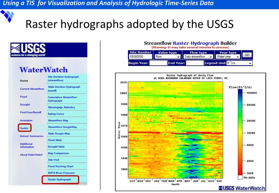
7 Raster hydrographs adopted by the USGS
8 Application: QA/QC CAN MT Fort Peck computed daily inflow (~72 yrs, 26,300 values) ID WY Switch to DST, systematic error Missing


9 Application: Multi-site comparison Drought index Wetter Drier Oregon

10 Inter-comparisons Value color Temporal persistence Spatial extent Year Month

11 Annual Max Daily Mean Flow Red River of the North at Fargo, ND Symbol size flow Flow (cfs) Year Max = 29, Min =

12 Case study 1 Colorado River Water Availability Study (CRWAS) How can climate simulations for water resources be re-purposed? Topics Hydrometeorology Climate change Water supply Consumptive use Decision support Reservoir management Instream flows Data visualization Elements a. Sites = 845 Diversions, Reservoirs, Stream gages, ISF reaches, Natural Flow Nodes, b. Parameters = 26 Demand, CU, Loss, Flow, c. Climate scenarios = 11 Historic, 2040 & 2070 simulations


13 Current data display Elements a. Sites 1 b. Parameters 1 c. Scenarios 11 a. Colorado River nr CO-UT state line b. Upstream Inflow c. All climate scenarios

14 Proposed data display Elements a. Sites 1 b. Parameters 1 c. Scenarios 1 a. Colorado River nr CO-UT state line b. Upstream Inflow c. Historic climate scenario


15 Proposed data display Elements a. Sites 1 b. Parameters 1 c. Scenarios 1 a. Colorado River nr CO-UT state line b. Upstream Inflow c G climate scenario

 c.")
16 New product display Elements a. Sites 1 b. Parameters 1 c. Scenarios 2 a. Colorado River nr CO-UT state line b. Upstream Inflow (new) c. (2070 G) (Historic)

17 Potential new products Elements a. Sites multiple b. Parameters multiple c. Scenarios multiple 1. Temporal signature 2. Up and downstream - or - basin to basin comparison 3. Dual parameter comparison 4. Scenario difference comparison (as shown earlier) 5. More complex intercomparisons
 5.")
18 Case study 2 Paralytic shellfish toxins in Puget Sound* How can multiple environmental time-series be integrated into a single summary plot? Topics Water quality Habitat monitoring Hydrometeorology Oceanography Public health Economics Climate change Decision support Ecological forecasting and trends Data visualization CAN WA * Moore, S.K., et al., Recent trends in paralytic shellfish toxins in Puget Sound, relationships to climate, and capacity for prediction of toxic events. Harmful Algae 8, doi: / j.hal

19 Background information Criteria driven approach for shellfish toxicity Time-series datasets: Traditional plots: Environmental factors 1. Sea surface temp ( C) 2. Sea surface salinity (psu) 3. Air temp ( C) 4. Precipitation (cm) 5. Streamflow (m 3 s -1 ) 6. Tidal height difference (m) 7. Upwelling (m 3 s m -1 ) 8. Wind speed (ms -1 )
 6. Tidal height difference (m) 7.")
 Missing 1,716 days Event")
20 Threshold example Observed streamflow Criterion: Flow 350 m 3 s -1 Met = 1, Not met = 0 Flow (m 3 s -1 ) Missing 1,716 days Event Windows
 Missing 1,716 days Event")

21 Calendar Year Case study results 1,840 days 2,513 days Apply specific criterion to specific layer If layers = 8 for any day; Then event window present Potential Event Windows 2,424 days 2,546 days 127 days 2,662 days 1,716 days 2,062 days 4,116 days Day of Year Missing
22 Benefits of temporal maps Natural way to view large datasets Quickly review and interpret Develop new types of products Cost effective and time efficient method Result = Competitive advantage

23 Questions? Visual Data Analytics, LLC Richard Koehler, PhD, PH Consulting, partnering, workshops Visit our website for more information.
Introduction to Raster Graphics and Applications
 Data Visualization Workshop May 7, 2015 Introduction to Raster Graphics and Applications Richard Koehler, PhD, PH NOAA, Boulder, CO [email protected] Source: usgs.gov Source: nrcs.gov Source: noaa.gov
Advanced Data Mining International, LLC. Clients Alcoa, BP, B&V, state agencies, water utilities, USACOE, USGS, USDOE, WERF, WRF..
 Advanced Data Mining International, LLC Greenville, SC; founded 2002 About ADMi Clients Alcoa, BP, B&V, state agencies, water utilities, USACOE, USGS, USDOE, WERF, WRF.. Focus Problem solving through data
Hydrologic Modeling using HEC-HMS
 Hydrologic Modeling using HEC-HMS Prepared by Venkatesh Merwade School of Civil Engineering, Purdue University [email protected] April 2012 Introduction The intent of this exercise is to introduce you
Adoption of an Interim 602(a) Storage Guideline. Final Environmental Assessment
 Storage Guideline. Final Environmental Assessment") Adoption of an Interim 602(a) Storage Guideline Final Environmental Assessment U.S. Department of the Interior Bureau of Reclamation March 2004 The mission of the Department of the Interior is to protect
Adoption of an Interim 602(a) Storage Guideline Final Environmental Assessment U.S. Department of the Interior Bureau of Reclamation March 2004 The mission of the Department of the Interior is to protect
FLOOD FORECASTING PRACTICE IN NORTHERN CALIFORNIA
 FLOOD FORECASTING PRACTICE IN NORTHERN CALIFORNIA California Department of Water Resources Post Office Box 219000, Sacramento, California 95821 9000 USA By Maurice Roos, Chief Hydrologist ABSTRACT Although
National Dam Safety Program Technical Seminar #22. When is Flood Inundation Mapping Not Applicable for Forecasting
 National Dam Safety Program Technical Seminar #22 Thursday February 19 th 2015 Emmittsburg, MD When is Flood Inundation Mapping Not Applicable for Forecasting Victor Hom Hydrologic Services Division National
Reservoir Simulations for the Delaware River Basin Flood of June, 2006
 Reservoir Simulations for the Delaware River Basin Flood of June, 2006 Middle Atlantic River Forecast Center State College, PA August 2007 (Revised 9/13/07) Introduction: In the late spring of 2005, the
Flash Flood Science. Chapter 2. What Is in This Chapter? Flash Flood Processes
 Chapter 2 Flash Flood Science A flash flood is generally defined as a rapid onset flood of short duration with a relatively high peak discharge (World Meteorological Organization). The American Meteorological
CRMS Website Training
 CRMS Website Training March 2013 http://www.lacoast.gov/crms Coastwide Reference Monitoring System - Wetlands CWPPRA Restoration Projects Congressionally funded in 1990 Multiple restoration techniques
Long-term Marine Monitoring in Willapa Bay. WA State Department of Ecology Marine Monitoring Program
 Long-term Marine Monitoring in Willapa Bay WA State Department of Ecology Marine Monitoring Program Ecology s Marine Waters Monitoring Program Goal: establish and maintain baseline environmental data Characterize
CRMS Website Training March 2015
 CRMS Website Training March 2015 http://www.lacoast.gov/crms CWPPRA Restoration Program CWPPRA was congressionally funded in 1990 and mandated 20 years of restoration project monitoring CWPPRA program
Colorado River Simulation System (CRSS)
") Colorado River Simulation System (CRSS) Overview and Use in Planning and Operation in the Colorado River Basin Donald J. Gross, P.E. Colorado River Management Presentation Topics Overview of the Colorado
Colorado River Simulation System (CRSS) Overview and Use in Planning and Operation in the Colorado River Basin Donald J. Gross, P.E. Colorado River Management Presentation Topics Overview of the Colorado
Standardized Runoff Index (SRI)
") Standardized Runoff Index (SRI) Adolfo Mérida Abril Javier Gras Treviño Contents 1. About the SRI SRI in the world Methodology 2. Comments made in Athens on SRI factsheet 3. Last modifications of the factsheet
Standardized Runoff Index (SRI) Adolfo Mérida Abril Javier Gras Treviño Contents 1. About the SRI SRI in the world Methodology 2. Comments made in Athens on SRI factsheet 3. Last modifications of the factsheet
Climate Change. Lauma M. Jurkevics - DWR, Southern Region Senior Environmental Scientist
 Climate Change A n o t h e r F a c t o r i n M a n a g i n g S o u t h e r n C a l i f o r n i a s W a t e r R e s o u r c e s Lauma M. Jurkevics - DWR, Southern Region Senior Environmental Scientist USEPA-Region
Stormwater Management in Chicago waterways :Basement Flooding and its prevention Kyungmin Kim
 Stormwater Management in Chicago waterways :Basement Flooding and its prevention Kyungmin Kim CE 394K GIS in Water Resources - David R. Maidment. Dec 4th 2015 Motivation and Objective Recently, Chicago
Estimating Potential Reduction Flood Benefits of Restored Wetlands
 Estimating Potential Reduction Flood Benefits of Restored Wetlands Kenneth W. Potter University of Wisconsin Introduction Throughout the summer of 1993 a recurring question was the impact of wetland drainage
Climate, Drought, and Change Michael Anderson State Climatologist. Managing Drought Public Policy Institute of California January 12, 2015
 Climate, Drought, and Change Michael Anderson State Climatologist Managing Drought Public Policy Institute of California January 12, 2015 Oroville Reservoir January 2009 Presentation Overview The Rules
Phoenix AMA References and Supplemental Reading
 Phoenix AMA References and Supplemental Reading References A Arizona Department of Economic Security (DES), 2005, Workforce Informer: Data file, accessed August 2005, http://www.workforce.az.gov. (Cultural
Damage Assessment in a large River Basin The Mekong Experience. Phan Nguyen& Anthony Green Mekong River Commission
 Damage Assessment in a large River Basin The Mekong Experience Phan Nguyen& Anthony Green Mekong River Commission Contents 1. Features and vulnerabilities 2. Influence of Changing Climate 3. Damage Assessment
Environmental Data Services for Delaware:
 Environmental Data Services for Delaware: Serving Emergency Responders, Planners, and Researchers Network Delaware Day November 6, 2013 Overview Operational Data Services More than just research DEOS and
Impact of Warming on Outflows from Selected Upper Watersheds in California
 Impact of Warming on Outflows from Selected Upper Watersheds in California Guobiao Huang (CA DWR), Tariq Kadir (CA DWR) and Francis Chung (CA DWR) California Water and Environmental Modeling Forum Pacific
AZ EGER-PATAK HIDROLÓGIAI VIZSGÁLATA, A FELSZÍNI VÍZKÉSZLETEK VÁRHATÓ VÁLTOZÁSÁBÓL ADÓDÓ MÓDOSULÁSOK AZ ÉGHAJLATVÁLTOZÁS HATÁSÁRA
 AZ EGER-PATAK HIDROLÓGIAI VIZSGÁLATA, A FELSZÍNI VÍZKÉSZLETEK VÁRHATÓ VÁLTOZÁSÁBÓL ADÓDÓ MÓDOSULÁSOK AZ ÉGHAJLATVÁLTOZÁS HATÁSÁRA GÁBOR KEVE 1, GÉZA HAJNAL 2, KATALIN BENE 3, PÉTER TORMA 4 EXTRAPOLATING
DISTRICT VALUES STATEMENTS, GOALS, ACTION ITEMS, AND ONGOING TASKS FOR 2015 Adopted by the Board of Directors December 10, 2014. Values Statements.
 DISTRICT VALUES STATEMENTS, GOALS, ACTION ITEMS, AND ONGOING TASKS FOR 2015 Adopted by the Board of Directors December 10, 2014 Values Statements. The Board opposes any new transfers of water from the
RECLAMATION. Colorado River Basin Water Supply and Demand Study. Managing Water in the West. Executive Summary
 RECLAMATION Managing Water in the West Colorado River Basin Water Supply and Demand Study Executive Summary u.s. Department of the Interior December 2012 Bureau of Reclamation Mission Statements The U.S.
USGS StreamStats Web Application for Kentucky
 USGS StreamStats Web Application for Kentucky Implementation of selected low- and mean-flow estimating equations Gary Martin, Hydrologist Project Chief U.S. Geological Survey, Kentucky Water Science Center
CRS 610 Ventura County Flood Warning System Website
 CRS 610 Ventura County Flood Warning System Website Purpose This document gives instructions and a description of the information available via the Ventura County Watershed Protection District s (VCWPD)
Real Time Flood Alert System (RTFAS) for Puerto Rico
 for Puerto Rico") Prepared in cooperation with the Puerto Rico Emergency Management Agency (PREMA) Real Time Flood Alert System (RTFAS) for Puerto Rico Overview The Real Time Flood Alert System is a web-based computer program,
Prepared in cooperation with the Puerto Rico Emergency Management Agency (PREMA) Real Time Flood Alert System (RTFAS) for Puerto Rico Overview The Real Time Flood Alert System is a web-based computer program,
New challenges of water resources management: Title the future role of CHy
 New challenges of water resources management: Title the future role of CHy by Bruce Stewart* Karl Hofius in his article in this issue of the Bulletin entitled Evolving role of WMO in hydrology and water
Section 2. Mono Basin Operations
 Section 2 Mono Basin Chapter 2 Mono Basin Compliance with State Water Resources Control Board Decision 1631 and Order Nos. 98-05 and 98-07 May 2008 Los Angeles Department of Water and Power Table of Contents
WATER AND DEVELOPMENT Vol. II - Types Of Environmental Models - R. A. Letcher and A. J. Jakeman
 TYPES OF ENVIRONMENTAL MODELS R. A. Letcher and A. J. Jakeman Centre for Resource and Environmental Studies, The Australian National University, Australia Keywords: environmental models, environmental
Ruissellement du Bassin Précipitation Abstractions Hydrogramme Flux de Base. Superposition Routage
 HEC-1 Leçon 11 This lesson will focus on how WMS can be used to develop HEC-1 modeling parameters and not on the fundamental hydrologic principles simulated by HEC-1. 1 Vue D Emsemble Utilisés Couramment
Development of Technical Data For Long Term Flood Solutions For the Red River Basin
 IDENTIFYING WHAT WE DIDN T KNOW Development of Technical Data For Long Term Flood Solutions For the Red River Basin LTFS Study Area U.S. Portion of Red River Basin (MN, ND & SD) Main Stem Red River Tributaries
06 - NATIONAL PLUVIAL FLOOD MAPPING FOR ALL IRELAND THE MODELLING APPROACH
 06 - NATIONAL PLUVIAL FLOOD MAPPING FOR ALL IRELAND THE MODELLING APPROACH Richard Kellagher 1, Mike Panzeri 1, Julien L Homme 1, Yannick Cesses 1, Ben Gouldby 1 John Martin 2, Oliver Nicholson 2, Mark
STATISTICAL SOFTWARE PACKAGE
 STATISTICAL SOFTWARE PACKAGE Jeff Harris [email protected], Gary [email protected], Matt Fleming [email protected], Beth Faber Ph.D. [email protected],
Hydrologic Aspects of Flood Warning Preparedness Programs
 US Army Corps of Engineers Hydrologic Engineering Center Hydrologic Aspects of Flood Warning Preparedness Programs August 1990 Approved for Public Release. Distribution Unlimited. TP-131 REPORT DOCUMENTATION
MANITOBA FLOOD PROTECTION PROJECTS Project Justification and Benefits. Science Imagination Collaboration
 MANITOBA FLOOD PROTECTION PROJECTS Project Justification and Benefits Science Imagination Collaboration Presentation Outline Extreme events on Red and Assiniboine Manitoba Flood Protection Works KGS Group
Applying GIS Analysis to Archaeological Research in Canada
 Applying GIS Analysis to Archaeological Research in Canada T A L K B Y D R. K I S H A S U P E R N A N T P R E S E N T E D A T G E O A L B E R T A 2 0 1 3 S E P T E M B E R 2 3, 2 0 1 3 Overview Review
Integrated Water and Sediment Management of Yellow River
 Keeping Health Life of Yellow River: Integrated Water and Sediment Management of Yellow River Shang Hongqi Yellow River Conservancy Commission 18 March 2009 Istanbul, Turkey Outline: I. Yellow River Characteristic
Methods for Determination of Safe Yield and Compensation Water from Storage Reservoirs
 US Army Corps of Engineers Hydrologic Engineering Center Methods for Determination of Safe Yield and Compensation Water from Storage Reservoirs October 1966 Approved for Public Release. Distribution Unlimited.
Hydrologic Engineering Techniques for Regional Water Resources Planning
 US Army Corps of Engineers Hydrologic Engineering Center Hydrologic Engineering Techniques for Regional Water Resources Planning October 1969 Approved for Public Release. Distribution Unlimited. TP-17
Environmental Data Management Programs
 Hydrologic Engineering Centre (HEC) Software CD Collection of programs, developed by the U.S. Army Corps of Engineers Environmental Data Management Programs Name: HEC-DSS Package Purpose: Data Storage
Understanding Complex Models using Visualization: San Bernardino Valley Ground-water Basin, Southern California
 Understanding Complex Models using Visualization: San Bernardino Valley Ground-water Basin, Southern California Zhen Li and Wesley R. Danskin U.S. Geological Survey, [email protected], [email protected],
RESTORATION AND ENHANCEMENT OF SOUTHERN CALIFORNIA LAGOONS
 RESTORATION AND ENHANCEMENT OF SOUTHERN CALIFORNIA LAGOONS by Hany Elwany, Ph.D. Scripps Institution of Oceanography Headwaters to Oceans Conference 25 October 2003 CE Ref #03-22 San Diego County Lagoons
THE COLORADO RIVER BASIN WATER SUPPLY AND DEMAND STUDY: MODELING TO SUPPORT A ROBUST PLANNING FRAMEWORK
 THE COLORADO RIVER BASIN WATER SUPPLY AND DEMAND STUDY: MODELING TO SUPPORT A ROBUST PLANNING FRAMEWORK Alan Butler, Hydrologic Engineer, Bureau of Reclamation, Lower Colorado Region, [email protected];
Curt Kerns, M.S., R.P.Bio., C.F.S. WetlandsPacific Corp. 250-722-7117 www.wetlandspacific.com
 Curt Kerns, M.S., R.P.Bio., C.F.S. WetlandsPacific Corp. 250-722-7117 www.wetlandspacific.com Presentation Historical perspectives Present perspectives How wetlands function Examples of natural wetlands
Vulnerability Assessment of New England Streams: Developing a Monitoring Network to Detect Climate Change Effects
 Vulnerability Assessment of New England Streams: Developing a Monitoring Network to Detect Climate Change Effects National Water Quality Monitoring Council 2012 Meeting Britta Bierwagen, National Center
Des Moines River Regulated Flow Frequency Study
 E S I Des Moines River Regulated Flow Frequency Study MINNESOTA WISCONSIN D E S C E D A R M I S S I M O I N S S I P P R A C C O O N R I V E R Saylorville Lake Des Moines - SE 6th St #* Lake Red Rock I
Climate Change on the Prairie:
 Climate Change on the Prairie: A Basic Guide to Climate Change in the High Plains Region - UPDATE Global Climate Change Why does the climate change? The Earth s climate has changed throughout history and
9.1. Adequacy of Available Data and Monitoring Efforts
 9. DATA MANAGEMENT Data management is a crucial aspect of successful implementation of the ARB IRWMP and its component projects. This section discusses the adequacy of available data and monitoring efforts,
Flash Flood Guidance Systems
 Flash Flood Guidance Systems Introduction The Flash Flood Guidance System (FFGS) was designed and developed by the Hydrologic Research Center a non-profit public benefit corporation located in of San Diego,
10/4/2012. 40 slide sample of Presentation. Key Principles to Current Stormwater Management
 40 slide sample of Presentation Please contact [email protected] if you would like the complete presentation Key Principles to Current Stormwater Management Distributed Control Measures Integrated
Latin American and Caribbean Flood and Drought Monitor Tutorial Last Updated: November 2014
 Latin American and Caribbean Flood and Drought Monitor Tutorial Last Updated: November 2014 Introduction: This tutorial examines the main features of the Latin American and Caribbean Flood and Drought
Whisky & Soda vs. WISKI & SODA. Eastern CA Collaborative Sharing WISKI with your Neighbours 1
 Whisky & Soda vs. WISKI & SODA Eastern CA Collaborative Sharing WISKI with your Neighbours 1 Eastern CA Collaborative Sharing WISKI With Your Neighbours Christine McClure, Quinte Conservation Gord Mountenay,
A HYDROLOGIC NETWORK SUPPORTING SPATIALLY REFERENCED REGRESSION MODELING IN THE CHESAPEAKE BAY WATERSHED
 A HYDROLOGIC NETWORK SUPPORTING SPATIALLY REFERENCED REGRESSION MODELING IN THE CHESAPEAKE BAY WATERSHED JOHN W. BRAKEBILL 1* AND STEPHEN D. PRESTON 2 1 U.S. Geological Survey, Baltimore, MD, USA; 2 U.S.
Lecture 4: Streamflow and Stream Gauging
 Lecture 4: Streamflow and Stream Gauging Key Questions 1. What is stream discharge and what controls its magnitude? 2. What is a hydrograph? 3. Where is the velocity highest in a stream? 4. Where is the
Real-time Global Flood Monitoring and Forecasting using an Enhanced Land Surface Model with Satellite and NWP model based Precipitation
 Real-time Global Flood Monitoring and Forecasting using an Enhanced Land Surface Model with Satellite and NWP model based Precipitation Huan Wu,2, Robert F. Adler, 2, Yudong Tian, 2, George J. Huffman
JASPERS Networking Platform
 JASPERS Networking Platform Promoting climate change adaptation, risk prevention and management in the Water Sector UK Emergency Warning System Rachel Brisley, Technical Director & Sophie Dusting, Analyst
Estuary Time Series Evaluations, Part 1
 Meeting of the Guadalupe, San Antonio, Mission, and Aransas Rivers and Mission, Copano, Aransas, and San Antonio Bays Basin and Bay Area Stakeholder Committee (BBASC) April 19, 211 Estuary Time Series
RIVERWARE DECISION SUPPORT TOOLS FOR PLANNING SUSTAINABLE RIVER DEVELOPMENT WITH HYDROPOWER
 RIVERWARE DECISION SUPPORT TOOLS FOR PLANNING SUSTAINABLE RIVER DEVELOPMENT WITH HYDROPOWER Edith A. Zagona 1, Balaji Rajagopalan 2 and Steven Setzer 3 1University of Colorado Center for Advanced Decision
The Integration of Hydrographic and Oceanographic Data in a Marine Geographic Information System U.S. Hydro 2015
 The Integration of Hydrographic and Oceanographic Data in a Marine Geographic Information System U.S. Hydro 2015 Karen Hart CARIS USA Oceanography and Hydrography Defined Oceanography: The branch of Earth
Water Budgets and Climate Change Guidance, Web Application CC Training and Case Study
 Water Budgets and Climate Change Guidance, Web Application CC Training and Case Study OCCIAR and Northern Conservation Authorities March 26-27, 2012 Mike Garraway, MNR Centre of Excellence for Water Quantity
Building & Developing the Environmental
 Building & Developing the Environmental Web Explorer for Riyadh City Authors: Engineer Yousef Bin Othman Al-Fariheedi Manager of Environmental Data Unit Environmental Management and Protection Department
Geoprocessing Tools for Surface and Basement Flooding Analysis in SWMM
 3 Geoprocessing Tools for Surface and Basement Flooding Analysis in SWMM Eric White, James Knighton, Gary Martens, Matthew Plourde and Rajesh Rajan A geoprocessing routine was used for the development
Critical Assets and Extreme Weather Process & Lessons
 Critical Assets and Extreme Weather Process & Lessons Steven Olmsted Intermodal Transportation Division Arizona Department of Transportation 2014 Transportation Asset Management Conference April 28-30,
HCP Team Meeting. November 18, 2015. icfi.com
 HCP Team Meeting November 18, 2015 icfi.com 1 Welcome and Introductions Where are we in the HCP process Hydrology modeling update Native fish survey Fish translocation Finalize covered activities Next
National Weather Service Flash Flood Modeling and Warning Services
 National Weather Service Flash Flood Modeling and Warning Services Seann Reed, Middle Atlantic River Forecast Center Peter Ahnert, Middle Atlantic River Forecast Center August 23, 2012 USACE Flood Risk
Abaya-Chamo Lakes Physical and Water Resources Characteristics, including Scenarios and Impacts
 LARS 2007 Catchment and Lake Research Abaya-Chamo Lakes Physical and Water Resources Characteristics, including Scenarios and Impacts Seleshi Bekele Awulachew International Water Management Institute Introduction
City of Calgary KISTERS KISTERS Overview Overview. KISTERS Software Solutions Water, Energy and Environmental Data May 19, 2015
 KISTERS Software Solutions Water, Energy and Environmental Data May 19, 2015 Who is KISTERS? Applications Modular Solutions Current Technologies Working with Your Data Discussion Applications Hydrometric
 Disaster Prevention Measures in Global-Local Context 4 th World Water Forum Dr. Yoshihiko Yamashita CTI Engineering Co., Ltd Association of Japanese Consulting Engineers Outline of Presentation Up-to to-date
Long Term Challenges for Tidal Estuaries
 A view from a former tidal river manager expert with experience from 6 decades living at, with and from the Tidal River Elbe chairman of the European Interreg Project TIDE (Tidal River Development) Land
Impact of water harvesting dam on the Wadi s morphology using digital elevation model Study case: Wadi Al-kanger, Sudan
 Impact of water harvesting dam on the Wadi s morphology using digital elevation model Study case: Wadi Al-kanger, Sudan H. S. M. Hilmi 1, M.Y. Mohamed 2, E. S. Ganawa 3 1 Faculty of agriculture, Alzaiem
ATTACHMENT 8: Quality Assurance Hydrogeologic Characterization of the Eastern Turlock Subbasin
 ATTACHMENT 8: Quality Assurance Hydrogeologic Characterization of the Eastern Turlock Subbasin Quality assurance and quality control (QA/QC) policies and procedures will ensure that the technical services
7. MASS BALANCE MODEL CALIBRATION
 7. MASS BALANCE MODEL CALIBRATION 7. OVERVIEW Chapter 5 presented development of the Hudson River Toxic Chemical Model (HUDTOX) which included the conceptual framework, governing equations and spatial-temporal
Risk and vulnerability assessment of the build environment in a dynamic changing society
 Risk and vulnerability assessment of the build environment in a dynamic changing society Limnei Nie SINTEF Building and infrastructure, P.O.Box 124 Blindern, NO-0314 Oslo, Norway. [email protected]
Project Theory-Climate Change and Traditional Ecological Knowledge Adaption in the Klamath Basin
 Project Theory-Climate Change and Traditional Ecological Knowledge Adaption in the Klamath Basin Frank K. Lake Lead Science and TEK Mentor for project Education 1995 B.S. University of California, Davis.
Science Infusion, RTO Transition & Phase-2 Planning
 Science Infusion, RTO Transition & Phase-2 Planning D.-J. Seo and Yuqiong Liu Hydrologic Ensemble Prediction Group (HEP) Hydrologic Science and Modeling Branch Hydrology Laboratory Office of Hydrologic
Ground-Water-Level Monitoring and the Importance of Long-Term Water-Level Data U.S. Geological Survey Circular 1217
 Ground-Water-Level Monitoring and the Importance of Long-Term Water-Level Data U.S. Geological Survey Circular 1217 by Charles J. Taylor William M. Alley Denver, Colorado 2001 U.S. DEPARTMENT OF THE INTERIOR