Assessing Rivers for Restoration Purposes. Ann L. Riley Waterways Restoration Institute
|
|
|
- Emery Howard
- 10 years ago
- Views:
Transcription
1 Assessing Rivers for Restoration Purposes Ann L. Riley Waterways Restoration Institute

2 Assessing Rivers for Restoration Purposes Ann L. Riley Waterways Restoration Institute

3 Assessing Rivers for Restoration Purposes Ann L. Riley Waterways Restoration Institute

4 Aliso Creek dam Grade controls can act as small dams and create channel instabilities.

5 Aliso Creek below dam Hungry water takes out long reaches of riparian restoration.

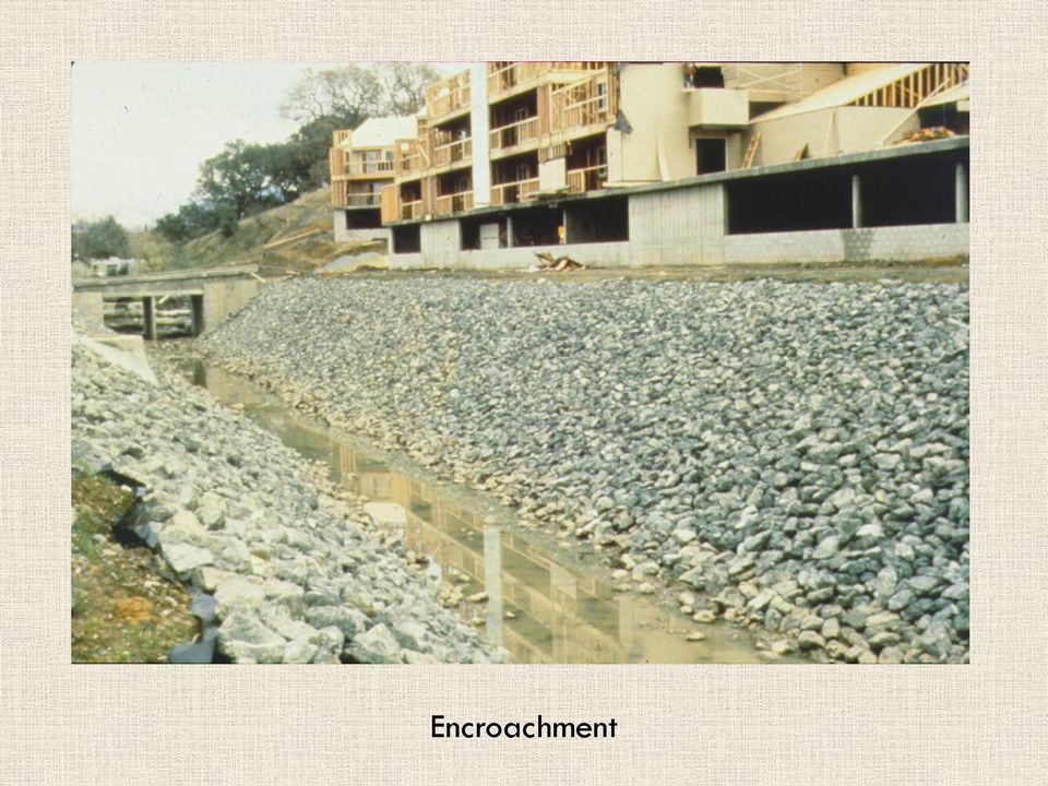
6 Encroachment
7 Torrey Pine Creek (failed grade control) Grade controls, large and small often are the source of channel problems.

8 Sacramento River (meander around rocks) Riprap often has failure built in to its use.

9 Baxter Creek (failing riprap) Failure of riprap occurs at all scales, small creeks and large rivers.

10 Steven's Creek too narrow Common problem: structural fixes without knowledge about stable creek shapes.

11 San Juan River(too straight) The channelization steepened the slope which caused incision and then failure of concrete lining on a federal flood control project.

12 Excess Sediment slope issues It has been common for flood control channels to be designed at unsustainable slopes.

13 Culvert caused Gully (San Diego) Headcuts frequently form above culverts put in a the wrong slope.

14 New Pinole Creek trestle : too low for next 100 years This locks in flooding problems upstream for another few generations.

15 Common Post Construction Problems Assessments need to address how to respond to, and avoid these common problems if river functions are to improve.

16 Meander in Concrete-lined Creek Channel We need to address sustainable channel slopes and meanders.

17 Step pool design Steep gradient streams need to address step pool design for restoration.

18 Napa tame river The Zen of flood control design for the Napa River, California.

19 Napa River floodplain restore mouth and lower flood level upstream Removing hydraulic constrictions: the first step in assessments to solve problems.

20 Napa pasture to floodplain This new floodplain lowers flood level by 3 feet in downtown area.

21 Napa demolish buildings
22 Napa floodplain restoration
23 Napa floodplain restoration
24 Napa new habitat in flood and marsh plain Monitoring shows habitat functions of restored floodplain.
25 Old Maxwell bridge
26 Maxwell bridge rebuilt to remove constriction
27 3rd street bridge :old
28 New third street bridge Bridge replacements which serve as key strategies to reducing flood damages should be part of federal cost sharing on projects: This is more sustainable than dredging the river repeatedly.
29 Napa downtown restoration River restoration is downtown restoration and builds the local economy.
30 Downtown river access
31 Willow Posts (driven into creek bank) New Assessment tools are helping guide the appropriate use of vegetation for river stabilization.
32 Willow Posts (sprouting quickly) Soli bioengineering can perform well under high shear stresses, and these are quantifiable.
33 Willowstand (bank stabilization)
34 Hydraulic constriction 1995
35 VUPRRT Hydraulic constrictions can endanger trains and the surrounding community.
36 Codornices culvert before This culvert prevented floodplain restoration.
37 Codornices culvert rebuild by RR to move flood flows The floodplain and channel restoration design informed the culvert replacement.
38 New Pinole creek trestle creating flooding This train trestle was dropped on a restored floodplain harming its functional values and performance.
39 Geomorph context needs to inform assessments Process based assessments can inform management actions and result in permits which protect the environment.
40 Channel evolution sketches can be rapid assessments which indicate level of degradation, the route to recovery and inform restoration or management.
41 Hey channel evol 0002 This represents one page of many process sketches which can be used to provide rapid assessments which can be applied to describing condition and guide appropriate management strategies.
42 Bankfull X-section Area (Bay Area graph) Restoration curves developed by regions can also provide rapid assessments on whether a channel is significantly different from others with similar watershed areas. A first level assessment.
43 Destabilizing Practices (Channel Widening) Examples of rapid process sketches which can inform management needs and developing solutions. Process assessments don t have to be too complicated to be useful.
44 Aliso Creek dam Grade controls can act as small dams and create channel instabilities.
45 Aliso Creek below dam Hungry water takes out long reaches of riparian restoration.
46 Encroachment
47 Torrey Pine Creek (failed grade control) Grade controls, large and small often are the source of channel problems.
48 Sacramento River (meander around rocks) Riprap often has failure built in to its use.
49 Baxter Creek (failing riprap) Failure of riprap occurs at all scales, small creeks and large rivers.
50 Steven's Creek too narrow Common problem: structural fixes without knowledge about stable creek shapes.
51 San Juan River(too straight) The channelization steepened the slope which caused incision and then failure of concrete lining on a federal flood control project.
52 Excess Sediment slope issues It has been common for flood control channels to be designed at unsustainable slopes.
53 Culvert caused Gully (San Diego) Headcuts frequently form above culverts put in a the wrong slope.
54 New Pinole Creek trestle : too low for next 100 years This locks in flooding problems upstream for another few generations.
55 Common Post Construction Problems Assessments need to address how to respond to, and avoid these common problems if river functions are to improve.
56 Meander in Concrete-lined Creek Channel We need to address sustainable channel slopes and meanders.
57 Step pool design Steep gradient streams need to address step pool design for restoration.
58 Napa tame river The Zen of flood control design for the Napa River, California.
59 Napa River floodplain restore mouth and lower flood level upstream Removing hydraulic constrictions: the first step in assessments to solve problems.
60 Napa pasture to floodplain This new floodplain lowers flood level by 3 feet in downtown area.
61 Napa demolish buildings
62 Napa floodplain restoration
63 Napa floodplain restoration
64 Napa new habitat in flood and marsh plain Monitoring shows habitat functions of restored floodplain.
65 Old Maxwell bridge
66 Maxwell bridge rebuilt to remove constriction
67 3rd street bridge :old
68 New third street bridge Bridge replacements which serve as key strategies to reducing flood damages should be part of federal cost sharing on projects: This is more sustainable than dredging the river repeatedly.
69 Napa downtown restoration River restoration is downtown restoration and builds the local economy.
70 Downtown river access
71 Willow Posts (driven into creek bank) New Assessment tools are helping guide the appropriate use of vegetation for river stabilization.
72 Willow Posts (sprouting quickly) Soli bioengineering can perform well under high shear stresses, and these are quantifiable.
73 Willowstand (bank stabilization)
74 Hydraulic constriction 1995
75 VUPRRT Hydraulic constrictions can endanger trains and the surrounding community.
76 Codornices culvert before This culvert prevented floodplain restoration.
77 Codornices culvert rebuild by RR to move flood flows The floodplain and channel restoration design informed the culvert replacement.
78 New Pinole creek trestle creating flooding This train trestle was dropped on a restored floodplain harming its functional values and performance.
79 Geomorph context needs to inform assessments Process based assessments can inform management actions and result in permits which protect the environment.
80 Channel evolution sketches can be rapid assessments which indicate level of degradation, the route to recovery and inform restoration or management.
81 Hey channel evol 0002 This represents one page of many process sketches which can be used to provide rapid assessments which can be applied to describing condition and guide appropriate management strategies.
82 Bankfull X-section Area (Bay Area graph) Restoration curves developed by regions can also provide rapid assessments on whether a channel is significantly different from others with similar watershed areas. A first level assessment.
83 Destabilizing Practices (Channel Widening) Examples of rapid process sketches which can inform management needs and developing solutions. Process assessments don t have to be too complicated to be useful.
84 Aliso Creek dam Grade controls can act as small dams and create channel instabilities.
85 Aliso Creek below dam Hungry water takes out long reaches of riparian restoration.
86 Encroachment
87 Torrey Pine Creek (failed grade control) Grade controls, large and small often are the source of channel problems.
88 Sacramento River (meander around rocks) Riprap often has failure built in to its use.
89 Baxter Creek (failing riprap) Failure of riprap occurs at all scales, small creeks and large rivers.
90 Steven's Creek too narrow Common problem: structural fixes without knowledge about stable creek shapes.
91 San Juan River(too straight) The channelization steepened the slope which caused incision and then failure of concrete lining on a federal flood control project.
92 Excess Sediment slope issues It has been common for flood control channels to be designed at unsustainable slopes.
93 Culvert caused Gully (San Diego) Headcuts frequently form above culverts put in a the wrong slope.
94 New Pinole Creek trestle : too low for next 100 years This locks in flooding problems upstream for another few generations.
95 Common Post Construction Problems Assessments need to address how to respond to, and avoid these common problems if river functions are to improve.
96 Meander in Concrete-lined Creek Channel We need to address sustainable channel slopes and meanders.
97 Step pool design Steep gradient streams need to address step pool design for restoration.
98 Napa tame river The Zen of flood control design for the Napa River, California.
99 Napa River floodplain restore mouth and lower flood level upstream Removing hydraulic constrictions: the first step in assessments to solve problems.
100 Napa pasture to floodplain This new floodplain lowers flood level by 3 feet in downtown area.
101 Napa demolish buildings
102 Napa floodplain restoration
103 Napa floodplain restoration
104 Napa new habitat in flood and marsh plain Monitoring shows habitat functions of restored floodplain.
105 Old Maxwell bridge
106 Maxwell bridge rebuilt to remove constriction
107 3rd street bridge :old
108 New third street bridge Bridge replacements which serve as key strategies to reducing flood damages should be part of federal cost sharing on projects: This is more sustainable than dredging the river repeatedly.
109 Napa downtown restoration River restoration is downtown restoration and builds the local economy.
110 Downtown river access
111 Willow Posts (driven into creek bank) New Assessment tools are helping guide the appropriate use of vegetation for river stabilization.
112 Willow Posts (sprouting quickly) Soli bioengineering can perform well under high shear stresses, and these are quantifiable.
113 Willowstand (bank stabilization)
114 Hydraulic constriction 1995
115 VUPRRT Hydraulic constrictions can endanger trains and the surrounding community.
116 Codornices culvert before This culvert prevented floodplain restoration.
117 Codornices culvert rebuild by RR to move flood flows The floodplain and channel restoration design informed the culvert replacement.
118 New Pinole creek trestle creating flooding This train trestle was dropped on a restored floodplain harming its functional values and performance.
119 Geomorph context needs to inform assessments Process based assessments can inform management actions and result in permits which protect the environment.
120 Channel evolution sketches can be rapid assessments which indicate level of degradation, the route to recovery and inform restoration or management.
121 Hey channel evol 0002 This represents one page of many process sketches which can be used to provide rapid assessments which can be applied to describing condition and guide appropriate management strategies.
122 Bankfull X-section Area (Bay Area graph) Restoration curves developed by regions can also provide rapid assessments on whether a channel is significantly different from others with similar watershed areas. A first level assessment.
123 Destabilizing Practices (Channel Widening) Examples of rapid process sketches which can inform management needs and developing solutions. Process assessments don t have to be too complicated to be useful.
The Teton Creek Restoration Project Summary:
 The Teton Creek Restoration Project Summary: The Teton Creek Restoration Project area extends for approximately one mile upstream from the Cemetery Road Bridge and includes the Aspen Pointe, The Aspens
Final Report. Dixie Creek Restoration Project. Funded by Plumas Watershed Forum
 Final Report Dixie Creek Restoration Project Funded by Plumas Watershed Forum Plumas Corporation January 2009 1 Background FR-CRM staff presented this project to the Dixie Valley Landowners Association
Neversink River East Branch
 Neversink River East Branch Management Unit 10 Summary of Post-Flood Recommendations Intervention Level Full restoration of the stream reach including the eroding bank site between Station 38380 and Station
A Stream Restoration Case Study in the California Central Coast
 International Erosion Control Association Annual Conference 2009, Reno, Nevada Case Study Technical Presentation A Stream Restoration Case Study in the California Central Coast Justin S. Rogers, P.E.,
Stream Rehabilitation Concepts, Guidelines and Examples. Objectives. Pierre Y. Julien. Three Laws of Stream Restoration
 Stream Rehabilitation Concepts, Guidelines and Examples Pierre Y. Julien Wuhan 2005 Objectives Part I - Stream restoration and rehabilitation: 1. Present and discuss important concepts, laws, criteria
Chehalis River Basin Flood Damage Reduction 2013-2015 Capital Budget Approved by Legislature in June 2013
 Chehalis River Basin Flood Damage Reduction 2013-2015 Capital Budget Approved by Legislature in June 2013 1. Design alternatives for large capital flood projects (basinlevel water retention and Interstate
Flood Hazard Area Technical Manual Section 8 Bank Stabilization and Stream Restoration
 Flood Hazard Area Technical Manual Section 8 Bank Stabilization and Stream Restoration Prepared by: New Jersey Section American Water Resources Association Stream Restoration Committee FHA Subcommittee
General Permit for Activities Promoting Waterway - Floodplain Connectivity [working title]
![General Permit for Activities Promoting Waterway - Floodplain Connectivity [working title]](/thumbs/39/18645965.jpg "General Permit for Activities Promoting Waterway - Floodplain Connectivity [working title]") General Permit for Activities Promoting Waterway - Floodplain Connectivity [working title] Purpose These rules set forth the conditions under which a person may, without an individual removal-fill permit
General Permit for Activities Promoting Waterway - Floodplain Connectivity [working title] Purpose These rules set forth the conditions under which a person may, without an individual removal-fill permit
3. Design Procedures. Design Procedures. Introduction
 Design Procedures 3. Design Procedures Introduction This chapter presents a procedure for the design of natural channels. The chapter primarily focuses on those physical properties of the channel required
Chapter 3 CULVERTS. Description. Importance to Maintenance & Water Quality. Culvert Profile
 Chapter 3 CULVERTS Description A culvert is a closed conduit used to convey water from one area to another, usually from one side of a road to the other side. Importance to Maintenance & Water Quality
Prattsville Berm Removal Project. 1.0 Project Location
 Prattsville Berm Removal Project 1.0 Project Location The project site is located between the New York State Route 23 Bridge over the Schoharie Creek and the Schoharie Reservoir. The restoration plan encompassed
BRIDGES ARE relatively expensive but often are
 Chapter 10 Bridges Chapter 10 Bridges Bridg Bridges -- usually the best, but most expensive drainage crossing structure. Protect bridges against scour. BRIDGES ARE relatively expensive but often are the
CITY UTILITIES DESIGN STANDARDS MANUAL
 CITY UTILITIES DESIGN STANDARDS MANUAL Book 2 (SW) SW9 June 2015 SW9.01 Purpose This Chapter provides information for the design of open channels for the conveyance of stormwater in the City of Fort Wayne.
Plumas Watershed Forum. Review of Ongoing Projects. Updated 10/1/008
 Plumas Watershed Forum Review of Ongoing Projects Updated 10/1/008 Hosselkus II Restoration Project Approved Funding: $80,000 (A funds) Expended By 10/1/08: $79,603 This pond-and-plug creek restoration
Mission Creek Flood Control & Restoration Project. City of Fremont, Alameda County
 Mission Creek Flood Control & Restoration Project City of Fremont, Alameda County Agenda Background Why are proposed improvements necessary? Proposed project components Challenges Construction schedule/phasing
DANIELS RUN STREAM RESTORATION, FAIRFAX, VIRGINIA: FLOODPLAIN ANALYSIS REPORT
 DANIELS RUN STREAM RESTORATION, FAIRFAX, VIRGINIA: FLOODPLAIN ANALYSIS REPORT By: Conor C. Shea Stream Habitat Assessment and Restoration Program U.S. Fish and Wildlife Service CBFO-S07-01 Prepared in
DRAFT SOUTH FORK SKYKOMISH RIVER
 DRAFT SOUTH FORK SKYKOMISH RIVER 9 levees and revetments / Approximately 1.1 miles of river bank are armored Revetments provide limited, localized erosion protection, but impact habitat Frequent and costly
Crossing creeks Stream crossings on farms
 Crossing creeks Stream crossings on farms Looking after all our water needs Crossing creeks Stream crossings on farms Looking after all our water needs Department of Water 168 St Georges Terrace Perth
Appendix C. Project Opportunities. Middle Twisp River (RM 7.8 18.12)
") Appendix C Project Opportunities Middle Twisp River (RM 7.8 18.12) This table describes project opportunities by project area. Locator maps of the project opportunities are included below the table. Reach
Appendix C Project Opportunities Middle Twisp River (RM 7.8 18.12) This table describes project opportunities by project area. Locator maps of the project opportunities are included below the table. Reach
Floodplain Connectivity in Restoration Design
 Floodplain Connectivity in Restoration Design 2015 Symposium on Restoration in a Contaminated Environment: Lessons Learned and Challenges in Moving Forward Part II April 2015 Karin Boyd Applied Geomorphology,
Floodplain Mapping. Vision. Events: 1 in 2 year 1 in 10 year 1 in 20 year 1 in 50 year 1 in 100 year Probable Maximum Flood Climate Change Impacts
 Events: 1 in 2 year 1 in 10 year 1 in 20 year 1 in 50 year 1 in 100 year Probable Maximum Flood Climate Change Impacts Floodplain Mapping 28 General Approaches to Reducing Flooding Risks Reducing Upstream
ROSE CREEK WATERSHED HYDROLOGIC, HYDRAULIC, SEDIMENT TRANSPORT, AND GEOMORPHIC ANALYSES TASK 1 EXISTING DATA AND INFORMATION SUMMARY REPORT BACKGROUND
 ROSE CREEK WATERSHED HYDROLOGIC, HYDRAULIC, SEDIMENT TRANSPORT, AND GEOMORPHIC ANALYSES TASK 1 EXISTING DATA AND INFORMATION SUMMARY REPORT BACKGROUND The Rose Creek Watershed (RCW) consists of three planning
Earth Science. River Systems and Landforms GEOGRAPHY 1710. The Hydrologic Cycle. Introduction. Running Water. Chapter 14.
 Earth Science GEOGRAPHY 1710 River Systems and Landforms DAVID R. SALLEE Robert W. Christopherson Charlie Thomsen Chapter 14 Introduction Rivers and streams are dynamic systems that continually adjust
Rhode Island NRCS received approximately $2.4 million in ARRA funds to implement four floodplain easement projects.
 American Recovery and Reinvestment Act (ARRA) Emergency Watershed Protection Program Floodplain Easements Rhode Island Natural Resources Conservation Service Rhode Island NRCS received approximately $2.4
EFFECTS OF ARUNDO DONAX ON RIVER HYDRAULICS, SEDIMENT TRANSPORT, AND GEOMORPHOLOGY, SANTA MARGARITA RIVER, CALIFORNIA
 EFFECTS OF ARUNDO DONAX ON RIVER HYDRAULICS, SEDIMENT TRANSPORT, AND GEOMORPHOLOGY, SANTA MARGARITA RIVER, CALIFORNIA René Leclerc Geomorphologist Robert C. MacArthur, Ph.D., P.E. Principal Headwaters
Baltimore County Stream Restoration Improves Quality of Life
 Baltimore County Stream Restoration Improves Quality of Life Baltimore County, Maryland, faces a challenge common to most areas experiencing urban growth: how to keep its waterways stable and healthy for
5.0 OVERVIEW OF FLOOD DAMAGE REDUCTION MEASURES
 5.0 OVERVIEW OF FLOOD DAMAGE REDUCTION MEASURES Flood damage reduction consists of two basic techniques structural and non-structural. Structural methods modify the flood and take the flood away from people
How To Check For Scour At A Bridge
 Case Studies Bridge Scour Inspection and Repair Edward P. Foltyn, P.E. Senior Hydraulic Engineer ODOT Bridge Unit 2013 PNW Bridge Inspectors Conference April 2013 REFERENCES Stream Stability at Highway
Streambank stabilization, streambank fencing, nuisance species control, riparian zone management
 Streambank stabilization, streambank fencing, nuisance species control, riparian zone management Stream Habitat Restoration Cost Considerations MARK COCKE, Civil Engineer Natural Resources Conservation
Topic 8: Open Channel Flow
 3.1 Course Number: CE 365K Course Title: Hydraulic Engineering Design Course Instructor: R.J. Charbeneau Subject: Open Channel Hydraulics Topics Covered: 8. Open Channel Flow and Manning Equation 9. Energy,
Napa River Restoration Projects
 Napa River Restoration Projects Shaun Horne, Napa County, [email protected] Jeremy Sarrow, Napa County, [email protected] The Napa River flows though one of the most scenic landscapes
Guo, James C.Y. (2004). Design of Urban Channel Drop Structure, J. of Flood Hazards News, December,
. Design of Urban Channel Drop Structure, J. of Flood Hazards News, December,") Guo, James C.. (004). esign of Urban Channel rop Structure, J. of Flood azards News, ecember, Guo, James C.., (009) Grade Control for Urban Channel esign, submitted to Elsevier Science, J. of ydro-environmental
Guo, James C.. (004). esign of Urban Channel rop Structure, J. of Flood azards News, ecember, Guo, James C.., (009) Grade Control for Urban Channel esign, submitted to Elsevier Science, J. of ydro-environmental
Appendix H Dredging and Stream Channel Restoration
 Appendix H Dredging and Stream Channel Restoration Mankind s intrusion into the natural environment in West Virginia began in earnest following the Civil War when extractive industries and settlement all
CHAPTER 3A Environmental Guidelines for STREAM CROSSING BY ALL-TERRAIN VEHICLES
 GOVERNMENT OF NEWFOUNDLAND AND LABRADOR DEPARTMENT OF ENVIRONMENT AND LABOUR CHAPTER 3A Environmental Guidelines for STREAM CROSSING BY ALL-TERRAIN VEHICLES WATER RESOURCES MANAGEMENT DIVISION Water Investigations
Environmental Case Study Decatur, Georgia, DeKalb County A Suburban Creek Resists Channelization
 Introduction A visual examination of Doolittle Creek in a highly developed suburban county in Georgia yielded telltale signs of a creek whose original streambed had been altered. Examination of official
Catchment Scale Processes and River Restoration. Dr Jenny Mant [email protected]. The River Restoration Centre therrc.co.uk
 Catchment Scale Processes and River Restoration Dr Jenny Mant [email protected] The River Restoration Centre therrc.co.uk 3 Main Catchment Elements Hydrology Energy associated with the flow of water affects
Steelhead Recovery in San Juan and Trabuco Creeks Watershed
 Steelhead Recovery in San Juan and Trabuco Creeks Watershed Are there fish now? Overview Final San Juan and Trabuco Creeks Watershed Management Plan Fish & Game Implementation NOAA Steelhead Recovery and
Ouachita River Floodplain Restoration Upper Ouachita NWR, Louisiana
 Ouachita River Floodplain Restoration Upper Ouachita NWR, Louisiana Interior Hydrologic Restoration Plan Mollicy Farms Unit The Nature Conservancy Louisiana Field Office 2011 Cover: Sediment laden water
Risk Analysis, GIS and Arc Schematics: California Delta Levees
 Page 1 of 7 Author: David T. Hansen Risk Analysis, GIS and Arc Schematics: California Delta Levees Presented by David T. Hansen at the ESRI User Conference, 2008, San Diego California, August 6, 2008 Abstract
4.2 Buena Vista Creek Watershed
 Buena Vista Creek Watershed 4.2 Buena Vista Creek Watershed Watershed Overview The Buena Vista Creek Watershed is the fourth-largest system within the Carlsbad Hydrologic Unit. The watershed extends approximately
SCHNEIDER CREEK REMEDIATION CLASS ENVIRONMENTAL ASSESSMENT ADDENDUM
 SCHNEIDER CREEK REMEDIATION CLASS ENVIRONMENTAL ASSESSMENT ADDENDUM PUBLIC MEETING FEBRUARY 8 TH, 2012 The City of Kitchener and Grand River Conservation Authority (GRCA) are undertaking an Environmental
1.7.0 Floodplain Modification Criteria
 1.7.0 Floodplain Modification Criteria 1.7.1 Introduction These guidelines set out standards for evaluating and processing proposed modifications of the 100- year floodplain with the following objectives:
Post-Flood Emergency Stream Intervention. After repairs. Training Manual
 Post-Flood Emergency Stream Intervention Before repairs After repairs Training Manual Originally prepared by: Delaware County Soil and Water Conservation District Delaware County Planning Department In
GLOSSARY OF TERMS CHAPTER 11 WORD DEFINITION SOURCE. Leopold
 CHAPTER 11 GLOSSARY OF TERMS Active Channel The channel that contains the discharge Leopold where channel maintenance is most effective, sediment are actively transported and deposited, and that are capable
San Diego Integrated Regional Water Management Implementation Grant Proposal Economic Analysis Flood Damage Reduction Costs and Benefits
 Attachment 9 San Diego Integrated Regional Water Management Economic Analysis Flood Damage Reduction Costs and Benefits Attachment 9 consists of the following items: Flood Damage Reduction Costs and Benefits.
Penticton Creek May 4, 2015 Council Meeting
 Penticton Creek May 4, 2015 Council Meeting Penticton Creek Council Meeting May 4, 2015 Penticton Creek in the Early Years Penticton Creek Council Meeting May 4, 2015 Penticton Creek Today Penticton Creek
The answers to some of the following questions are separated into two major categories:
 Following the recent flooding events for Front Range communities in Colorado, property owners, communities, and the National Flood Insurance Program are being presented with some new challenges in the
The students will be working in and alongside the stream, so safety is a consideration. Suitable sites should have the following characteristics:
 Measuring Stream Banks: Height and Slope Stream bank heights and slopes are of interest because they yield information relevant to bank erosion and stability. A high, steep bank is likely to be unstable
Vermont Economic Resiliency Initiative (VERI) Community Forum Barre City & Barre Town
 Community Forum Barre City & Barre Town") Vermont Economic Resiliency Initiative (VERI) Community Forum Barre City & Barre Town MEETING NOTES April 16, 2015 6:00 8:00 PM VERI Project Overview With funding from the US Economic Development Administration
Vermont Economic Resiliency Initiative (VERI) Community Forum Barre City & Barre Town MEETING NOTES April 16, 2015 6:00 8:00 PM VERI Project Overview With funding from the US Economic Development Administration
ECONOMIC ANALYSIS FLOOD DAMAGE REDUCTION. Lower Carmel River Floodplain Restoration and Enhancement Project
 ECONOMIC ANALYSIS FLOOD DAMAGE REDUCTION Lower Carmel River Floodplain Restoration and Enhancement Project I. Description of the Project and its Relationship to Other Projects in the Proposal The Lower
CHAPTER 5 OPEN CHANNEL HYDROLOGY
 5.4 Uniform Flow Calculations 5.4.1 Design Charts CHAPTER 5 OPEN CHANNEL HYDROLOGY Following is a discussion of the equations that can be used for the design and analysis of open channel flow. The Federal
Basic Principles of Channel Design
 United States Department of Agriculture Natural Resources Conservation Service Stream Restoration Design Chapter 7 Basic Principles of Channel Design Issued August 2007 Cover photo: Where modification
HCP Team Meeting. November 18, 2015. icfi.com
 HCP Team Meeting November 18, 2015 icfi.com 1 Welcome and Introductions Where are we in the HCP process Hydrology modeling update Native fish survey Fish translocation Finalize covered activities Next
Monitoring Riparian Areas With a Camera
 Monitoring Riparian Areas With a Camera By Michael DeLasaux 1, Holly George 2, and Philip Mainwaring 3 Riparian areas are next to streams, springs, rivers, ponds and lakes. Physical characteristics that
Emergency Streambank Restoration/Stabilization. Kentucky Division of Water Water Quality Certification May 2010 Educational Assistance
 Emergency Streambank Restoration/Stabilization Kentucky Division of Water Water Quality Certification May 2010 Educational Assistance Due to the severity of the recent rains and flooding occurrences, the
Streambank stabilization, streambank fencing, nuisance species control, riparian zone management
 Streambank stabilization, streambank fencing, nuisance species control, riparian zone management Stream Restoration Cost Estimates BRIAN BAIR USDA Forest Service Gifford-Pinchot National Forest 1262 Hemlock
WATER RESOURCES ENGINEERING DESIGN LANDSCAPE ECOLOGY AND RIVER RESTORATION. www.sindlar.eu
 Geomorphological processes of watercourse development, system of typology and application of the results in practice Part 01 Analysis of geomorphological processes in watercourses Part 02 Applications
MONITORING TOOLS AND METHODS. Michelle Buzalsky Rangeland Management Technician Shoshone National Forest
 MONITORING TOOLS AND METHODS Michelle Buzalsky Rangeland Management Technician Shoshone National Forest MONITORING TOOLS Tools for Monitoring Transect Stakes (PVC pipe, Rebar) 100 Tape Two Carpenter Rules
Riprap-lined Swale (RS)
") Riprap-lined Swale (RS) Practice Description A riprap-lined swale is a natural or constructed channel with an erosion-resistant rock lining designed to carry concentrated runoff to a stable outlet. This
Riprap-lined Swale (RS) Practice Description A riprap-lined swale is a natural or constructed channel with an erosion-resistant rock lining designed to carry concentrated runoff to a stable outlet. This
Interim Technical Guidelines for the Development of Environmental Management Plans for Underground Infrastructure Revised - July 2013.
 Interim Technical Guidelines for the Development of Environmental Management Plans for Underground Infrastructure Revised - July 2013 Rationale Underground infrastructure may be at risk from valley, streambank
Outlet stabilization structure
 Overview of Sedimentation and Erosion Control Practices Practice no. 6.41 Outlet stabilization structure Erosion at the outlet of channels, culverts, and other structures is common, and can cause structural
Stream Restoration Making It Happen: The Restoring The Waters Project
 Stream Restoration Making It Happen: The Restoring The Waters Project STEPHEN FROST, Fairfield City Council ROD WIESE, Department of Land & Water Conservation BARBARA SCHAFFER, Schaffer Barnsley Landscape
How To Assess An Area For Erosion
 SKY BASIN (UPPER CA 1 WATERSHED) EROSION ASSESSMENT Prepared by Kevin Drake, CPESC Integrated Environmental Restoration Services, Inc. August 2014 COMMON GROUND UNCOMMON SOLUTIONS P.O. BOX 7559 2780 LAKE
30-DAY PUBLIC NOTICE CHELSEA RIVER, EAST BOSTON MASSACHUSETTS EMERGENCY STREAMBANK PROTECTION PROJECT
 PUBLIC NOTICE Engineering/Planning 696 Virginia Road Concord, MA 01742 Date: 10 November, 2015 Comment Period Ends: 10 December, 2015 In Reply, Refer To: Robert Russo Or by e-mail: [email protected]
Background Information: The Mamquam River Floodplain Restoration Project
 Background Information: The Mamquam River Floodplain Restoration Project The Mamquam River Floodplain Restoration project is being undertaken in partnership with the Squamish River Watershed Society, Fisheries
Flood Risk Management
 Flood Risk Management Value of Flood Risk Management Every year floods sweep through communities across the United States taking lives, destroying property, shutting down businesses, harming the environment
Flood Risk Management
 Flood Risk Management Value of Flood Risk Management Value to Individuals and Communities Every year floods sweep through communities across the United States taking lives, destroying property, shutting
 Coldwater Heritage Partnership Implementation Grant Final Report Morrison Run Watershed Restoration Project Western Pennsylvania Conservancy Project Summary The goal of the Morrison Run Watershed Restoration
Waterway Technote Planning
 Waterway Technote Planning Contents Benefits to planning your waterway management 1 Prioritising waterway management where to start? 1 What are your priorities? 1 Start with the best areas or those at
CHAPTER 9 CULVERTS 2005
 CHAPTER 9 CULVERTS 2005 Culverts 9-1 Chapter Table of Contents 9.1 - Introduction 9-5 9.2 - Policy and Practice 9-5 9.3 - Large, Medium and Small Culverts 9-8 9.4 - Sources of Information 9-8 9.5 - Culvert
https://orm.usace.army.mil/orm2/f?p=106:34:4198546103662037::no::
 Page 1 of 6 APPROVED JURISDICTIONAL DETERMINATION FORM U.S. Army Corps of Engineers JD Status: DRAFT SECTION I: BACKGROUND INFORMATION A. REPORT COMPLETION DATE FOR APPROVED JURISDICTIONAL DETERMINATION
Restoring Ecosystems. Ecosystem Restoration Services
 Restoring Ecosystems Ecosystem Restoration Services 2 Ecosystem Restoration Services AECOM s integrated approach sciencebased planning, with innovative design and execution delivers sustainable and cost-effective
Adopted 9/23/98 CHATTAHOOCHEE CORRIDOR PLAN. The goals of the Chattahoochee Corridor Plan (hereinafter also referred to as the Plan ) are:
 are:") CHATTAHOOCHEE CORRIDOR PLAN Adopted 9/23/98 PART 1: GOALS. POLICY. COVERAGE. A. Goals The goals of the Chattahoochee Corridor Plan (hereinafter also referred to as the Plan ) are: 1. Preservation and protection
CHATTAHOOCHEE CORRIDOR PLAN Adopted 9/23/98 PART 1: GOALS. POLICY. COVERAGE. A. Goals The goals of the Chattahoochee Corridor Plan (hereinafter also referred to as the Plan ) are: 1. Preservation and protection
LATEST ENHANCEMENTS TO THE RIVERMorph STREAM RESTORATION SOFTWARE
 LATEST ENHANCEMENTS TO THE RIVERMorph STREAM RESTORATION SOFTWARE J. George Athanasakes, PE RIVERMorph, LLC 1901 Nelson Miller Parkway Louisville, KY 40223-2177 233 BIOGRAPHICAL SKETCH J. George Athanasakes,
Appendix 4-C. Open Channel Theory
 4-C-1 Appendix 4-C Open Channel Theory 4-C-2 Appendix 4.C - Table of Contents 4.C.1 Open Channel Flow Theory 4-C-3 4.C.2 Concepts 4-C-3 4.C.2.1 Specific Energy 4-C-3 4.C.2.2 Velocity Distribution Coefficient
Muddy River Restoration Project Project Description
 Muddy River Restoration Project Project Description Since the fall of 1996, the Muddy River has flooded three times, causing damage to residents, businesses institutions and the public transit system in