Bicycle and Pedestrian Facility Design Discussion
|
|
|
- Irma Parks
- 7 years ago
- Views:
Transcription
1 HEAL Active Transportation Bicycle and Pedestrian Facility Design Discussion September 9, 2014

2 Major Design Considerations Rural and urban Areas Sidewalk location considerations Crosswalk locations and safety Bicycle accommodation on roadways Parking issues Speeding and traffic calming Sidewalk typical section design Intersections One-way streets

3 Basic Design Parameters Sidewalks 5 wide with 2% cross slope (at driveways also) Layout route to minimize crosswalks Crosswalks at intersections are usually safer than midblock crosswalks Minimize crosswalk length Separate sidewalks from roadways as much as possible Bicycle Accommodation Roadway lanes are typically 11 Shoulders/Bicycle lanes should be 4 wide (5 where curb is present)

4 Basic Design Parameters

5 Basic Design Parameters

6 Basic Design Parameters

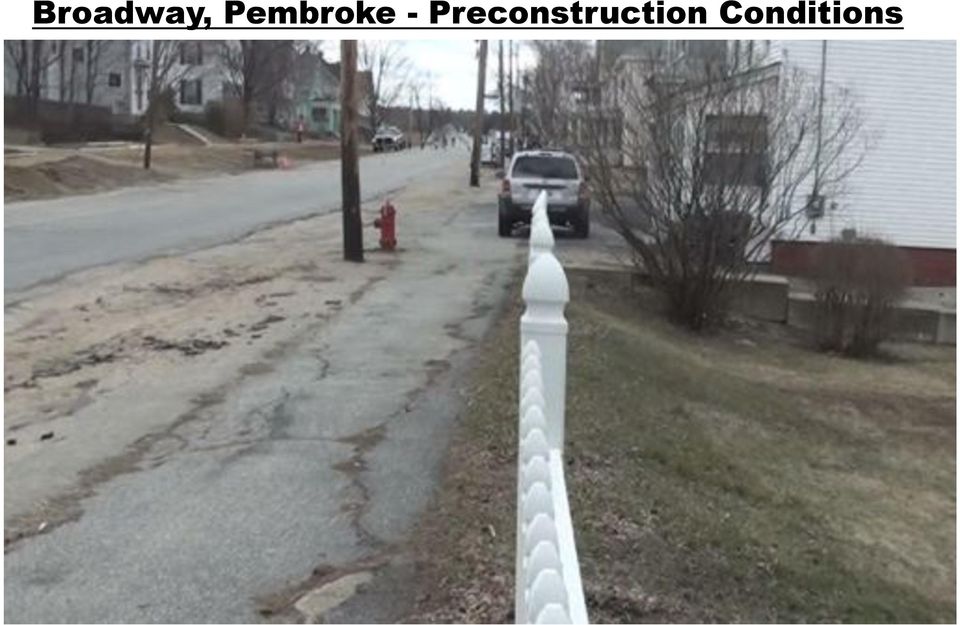
7 Broadway, Pembroke - Preconstruction Conditions Densely populated residential area Existing sidewalks in poor condition Broadway is wide open road with no curbing Two-way streets add to traffic congestion at school Major drainage problems Water system and gas system improvements Pedestrian safety at the school needed attention

8 Broadway, Pembroke - Preconstruction Conditions
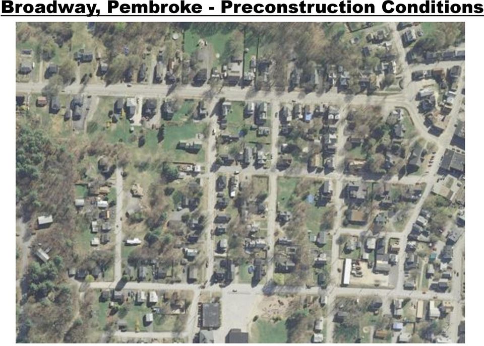
9 Broadway, Pembroke - Preconstruction Conditions

10 Broadway, Pembroke - Preconstruction Conditions
11 Broadway, Pembroke Design Goals Rebuild sidewalks to comply with ADA Add curbing project wide to define roadway areas Create a one-way circulation pattern (Maple and Pine) Include angle parking on east side of roadway Improve pedestrian safety at the school by minimizing vehicle/pedestrain conflicts at front entrance

12 Broadway, Pembroke Post Construction Conditions

13 Broadway, Pembroke Post Construction Conditions

14 Broadway, Pembroke Post Construction Conditions
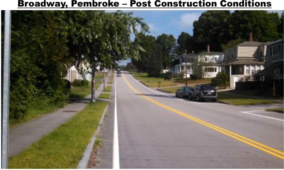
15 Broadway, Pembroke Post Construction Conditions
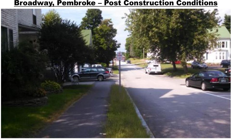
16 Broadway, Pembroke Post Construction Conditions

17 Broadway, Pembroke Village School

18 Broadway, Pembroke Village School

19 Broadway, Pembroke Village School

20 Broadway, Pembroke Summary Mailbox locations important to consider Creating a one-way circulation pattern drastically improved pedestrian safety at the school Back in angle parking was accepted by area residents with no complaints Village School improvements further improved safety for students being dropped off and walkers Street trees would have helped narrow scale of roadway Bicycle advocacy may have helped refine design

21 Newbury Harbor Pedestrian Project Preconstruction Conditions Small rural community center No sidewalks heavy pedestrian activity in summer Unsafe pedestrian areas at Town dock/beach parking area Intersection wide open allowing fast turns by cars and trucks Wide open roadway shoulders and poor access control leading to speeding Standard street lighting
22 Newbury Harbor Project - Preconstruction Conditions
23 Newbury Harbor Project - Preconstruction Conditions
24 Newbury Harbor Project - Preconstruction Conditions
25 Newbury Harbor Project - Preconstruction Conditions
26 Newbury Harbor Project - Preconstruction Conditions
27 Newbury Harbor Project Preconstruction Conditions
28 Newbury Harbor Project - Preconstruction Conditions
29 Newbury Harbor Project - Preconstruction Conditions
30 Newbury Harbor Project - Design Considerations Provide new sidewalks between municipal complex/library/town beach Create a safe pedestrian route at parking lot near the beach/docks including pedestrian bridge Create safe crosswalk locations Redesign the intersection to slow traffic down Provide improved bicycle accommodation Traffic calming to reduce speeding Shift roadway about 4 feet to accommodate sidewalks New street lighting and landscaping
31 Newbury Harbor Project Post Construction Conditions
32 Newbury Harbor Project - Post Construction
33 Newbury Harbor Project - Post Construction
34 Newbury Harbor Project - Post Construction
35 Newbury Harbor Project - Post Construction Conditions
36 Newbury Harbor Project - Post Construction
37 Newbury Harbor Project - Post Construction
38 Newbury Harbor Project - Post Construction
39 Newbury Harbor Project - Post Construction
40 Newbury Harbor Project - Summary Identify destinations/pedestrian routes early Parking spaces at Town Beach were sacrificed to improve pedestrian safety and create sitting areas Create enjoyable spaces in large pedestrian areas (not all concrete) that people will use Curbing, trees and ornamental lights (locations) are critical to visual character of roadway Create a balance between large vehicles and traffic calming at the intersection
41 Central Square, Bristol Preconstruction Conditions Downtown, densely populated, commercial area Many missing sidewalk connections Unsafe crosswalks Poor bicycle accommodation on roadways Vehicle speeding and traffic calming Wide open intersection with poorly defined lanes One-way operation change on North Main Street New lighting and landscaping
42 Central Square, Bristol - Preconstruction Conditions
43 Central Square, Bristol - Preconstruction Conditions
44 Central Square, Bristol - Preconstruction Conditions
45 Central Square, Bristol - Preconstruction Conditions
46 Central Square, Bristol - Preconstruction Conditions
47 Central Square, Bristol - Preconstruction Conditions
48 Central Square, Bristol - Design Objectives Improve crosswalk safety Add missing sidewalk connections Provide bicycle accommodation on roadways Minimize loss in parking spaces and locate new parking spaces where possible Create a visually constrained corridor with street trees and other streetscape elements for traffic calming Intersection improvements for pedestrian/vehicle safety One-way operation change on North Main Street for safety Create a Town Common area
49 Central Square, Bristol - Post Construction Conditions
50 Central Square, Bristol - Post Construction Conditions
51 Central Square, Bristol - Post Construction Conditions
52 Central Square, Bristol - Post Construction Conditions
53 Central Square, Bristol - Post Construction Conditions
54 Central Square, Bristol - Post Construction Conditions
55 Central Square, Bristol - Post Construction Conditions
56 Central Square, Bristol - Post Construction Conditions
57 Central Square, Bristol - Post Construction Conditions
58 Central Square, Bristol - Post Construction Conditions
59 Central Square, Bristol - Post Construction Conditions Improved visibility When leaving the parking space, motorists are able to see oncoming traffic. Decreased number of collisions Motorists no longer have to back out blindly from their parking space.s Improved safety For children. Car doors open in a manner that directs children to the back of the vehicle, ushering them towards the sidewalk rather than the street. For cyclists. As vehicles exit their parking stall, they are able to see cyclists in the roadway. Improved loading and unloading Trunks are adjacent to the sidewalk and open car doors offer protection from the street, allowing loading and unloading to occur outside of the traveled roadway.
60 Central Square, Bristol - Summary Back-in angle parking public acceptability can be challenging Flush island design (curb with stamped concrete) changed to stamped asphalt during construction Care must be taken when placing trees in commercial areas Locate new parking spaces where possible (back-in angle) Wide sidewalks encourage outdoor dining If a Town common is created it will be used Beautiful Streetscapes encourage investments
61 Conclusion Opportunities to allocate underused sections of roadways are everywhere Balance between large vehicles, bicycles and pedestrians a challenge Cannot tell people enough about what the impacts will be during construction Use back in angle parking wherever possible Beautiful streetscapes encourage investments Pedestrian and bicycle advocates must get involved during the design/public meeting process
 Walkable Communities Florida Department of Transportation State Safety Office Pedestrian and Bicycle Program April 1995 www.dot.state.fl.us/safety Twelve Steps for an Effective Program Page 1 Twelve Steps
6: LANE POSITIONS, TURNING, & PASSING
 6: LANE POSITIONS, TURNING, & PASSING BASIC LANE POSITIONS Traffic law says that slower vehicles should stay to the right. But where exactly should bicycles ride? Here are some basics. Never Ride Against
BEST PRACTICES. Smart Transportation is a key concept for the Paoli Roadway Improvement Project.
 Smart Transportation Smart Transportation is a key concept for the Paoli Roadway Improvement Project. PennDOT s Smart Transportation Guidebook (2008) outlines a comprehensive approach to transportation
VERTICAL SPEED CONTROL DEVICES
 H-3.8 VERTICAL SPEED CONTROL DEVICES GENERAL 1. Description This standard identifies minimum requirements that shall be met for all Vertical Speed Control Devices in the design and construction of elements
ENGINEERING SOLUTIONS FOR DESIGNING YOUR SAFE ROUTES
 How to Get Started ENGINEERING SOLUTIONS FOR DESIGNING YOUR SAFE ROUTES Design Elements Selecting appropriate design treatments for school neighborhoods creates environments that address the needs of all
HIGHWAY DESIGN REPORT. Appendix 4. Proposed Design Principles for City Passings
 HIGHWAY DESIGN REPORT Appendix 4 Proposed Design Principles for City Passings June 2000 Contents Page 1 Introduction 2 1.1 Purpose 2 1.2 Definition of city passing 2 1.3 Safety Problems 2 1.4 Planning
Measuring the Street:
 Measuring the Street: New Metrics for 21st Century Streets 1 Measuring the Street: New Metrics for 21st Century Streets New York City s streets are constantly called on to the meet new and varied needs
chapter 3 basic driving skills
 chapter 3 basic driving skills When curving to the left, keep the front wheels close to the right edge of the lane to keep your driver s side rear wheels out of the next lane of traffic. Curve ahead slow
TEST ON Driving Safely Among Bicyclists and Pedestrians
 TEST ON Driving Safely Among Bicyclists and Pedestrians Next you will take a 16 question test about driving safely among bicyclists and pedestrians. Please take out a sheet of paper to mark down and score
Guelph Driving School. 246 WOOLWICH ST. Unit C Guelph, Ontario N1H 3V9. Office: 519-829-8801 Cell: 519-362-5664. Email: info@guelphdrivingschool.
 246 WOOLWICH ST. Unit C Guelph, Ontario N1H 3V9 Office: 519-829-8801 Cell: 519-362-5664 Email: info@guelphdrivingschool.com Dear Student, We would like to take this opportunity to thank you for choosing
OVERVIEW PROJECT SUMMARY
 OVERVIEW Cesar Chavez showcases how to successfully redesign a primary arterial route into a neighborhood destination, improving modal share, water sensitive design, biodiversity and safety whilst maintaining
Multi-Modal Corridor Degree of Complexity: High Cost/Benefit: High
 Multi-Modal Corridor Degree of Complexity: Cost/Benefit: Maintain the same level of service for Ensures continuous flow through the Might impact other transportation Consider road diet and/or different
RESIDENTIAL DRIVEWAYS
 RESIDENTIAL DRIVEWAYS If you have specific questions or want to confirm your plans, our staff is available to assist in person, by telephone, or by e-mail. City of St. Petersburg Division of Development
Stop The stop sign, a red octagon with white lettering, means come to a full stop and be sure the way is clear before proceeding.
 Tr a f f i c S i g n s 7 7. TRAFFIC SIGNS Many collisions and near crashes occur as a result of drivers who ignore or fail to respond appropriately to traffic signs. It is essential that the meaning of
Downtown Tampa Transportation Vision
 Downtown Tampa Transportation Vision Executive Summary August 1, 2006 Hillsborough County Metropolitan Planning Organization County Center, 18 th Floor Tampa, Florida 33602 813-272-5940 www.hillsboroughmpo.org
Goals & Objectives. Chapter 9. Transportation
 Goals & Objectives Chapter 9 Transportation Transportation MISSION STATEMENT: TO PROVIDE A TRANSPORTATION NETWORK CAPABLE OF MOVING PEOPLE AND GOODS EFFICIENTLY AND SAFELY. T he transportation system
Lincoln Downtown Master Plan Update
 Lincoln Downtown Master Plan Update Table of Contents Executive Summary........................................... 1 Complete Streets Framework.................................... 3 Promenade Creating
Topic 2 11/28/2012 Blocks & Street Network
 TOPIC 2 Blocks & Street Network Implementation Note: 1. Some recommendations are summarized in the tables herein. For complete recommendation language, please see the. 2. Recommendations referenced in
Context Sensitive Design for Urban Transportation in West Philadelphia
 Context Sensitive Design for Urban Transportation in West Philadelphia Transportation Research Board 85 th Annual Meeting 24 January 2006 Jeffrey M. Casello University of Waterloo Robert Wright City of
Median Bus Lane Design in Vancouver, BC: The #98 B-Line
 Li 1 Median Bus Lane Design in Vancouver, BC: The #98 B-Line Simon Li, P.Eng. PTOE Acting Program Manager, Road and Bridge Projects TransLink (Greater Vancouver Transportation Authority) 1600 4720 Kingsway
ADA POST INSPECTION CHECKLIST. Job No. Route County Location
 ADA POST INSPECTION CHECKLIST Job No. Route County Location SIDEWALKS All sidewalks constructed within the project limits are ADA compliant. Sidewalks are 5 or greater in width. Exception, existing sidewalks
CHAPTER 2 TRAFFIC SIGNS AND HIGHWAY MARKINGS
 CHAPTER 2 TRAFFIC SIGNS AND HIGHWAY MARKINGS This chapter summarizes traffic signs, signals and road markings that control the flow of traffic, making streets and highways safer for motorists, bicyclists
FY 2011 OHIO SMALL CITIES COMMUNITY DEVELOPMENT BLOCK GRANT COMPREHENSIVE DOWNTOWN REVITALIZATION PROGRAM
 CITYOFOBERLIN OHIO CITY OF OBERLIN, OHIO FY 2011 OHIO SMALL CITIES COMMUNITY DEVELOPMENT BLOCK GRANT COMPREHENSIVE DOWNTOWN REVITALIZATION PROGRAM Background In October, 2011, the City of Oberlin Planning
Safety Evidence for Bicycling
 Photo: Boegh (Flickr) Cycling in Cities Research Program School of Population & Public Health The University of British Columbia Faculty of Health Sciences Simon Fraser University Driving near bicyclists
WESTFIELD-WASHINGTON ADVISORY PLAN COMMISSION December 7, 2015 1512-SPP-24 & 1512-ODP-24
 Petition Number: Subject Site Address: Petitioner: Request: East side of Oak Road, north of 151 st Street Langston Development Co. Primary Plat and Overall Development Plan amendment review for Mapleridge
Bicycle and Pedestrian Subcommittee (BPS) Recommendation FY 2015 Transportation Alternatives Program (TAP) Allocation
 Recommendation FY 2015 Transportation Alternatives Program (TAP) Allocation") Bicycle and Pedestrian Subcommittee (BPS) Recommendation FY 2015 Transportation Alternatives Program (TAP) Allocation The Montgomery Metropolitan Planning Organization (MPO) receives a direct annual allocation
Bicycle and Pedestrian Subcommittee (BPS) Recommendation FY 2015 Transportation Alternatives Program (TAP) Allocation The Montgomery Metropolitan Planning Organization (MPO) receives a direct annual allocation
Urban Design Interventions Towards a Bike Friendly City
 Denne artikel er publiceret i det elektroniske tidsskrift Artikler fra Trafikdage på Aalborg Universitet (Proceedings from the Annual Transport Conference at Aalborg University) ISSN 1603-9696 www.trafikdage.dk/artikelarkiv
These "rules of the road" are based on Texas Transportation Code statutes. Find the complete bicycle code at the bottom of the page
 Texas Bicycle Laws These "rules of the road" are based on Texas Transportation Code statutes. Find the complete bicycle code at the bottom of the page Bicyclists have the rights and duties of other vehicle
Road Signs Recognition Quiz
 Road Signs Recognition Quiz Place your answer for each of the signs/pavement markings on the answer sheet. Ready to Roll? Here Comes Sign # 1... #1 A No right turn B Right turn only C Warning, no turn
Roadway Cost Per Centerline Mile Revised June 2014
 Rural Arterial From LRE MOT * Mobilization * Subtotal Total PE Design (15%) CEI (15%) Total Project ** New (2-Lane Roadway) with 5' Paved Shoulders $3,351,896 $335,190 $368,709 $4,055,794 $1,013,949 $5,069,743
City of Auburn Americans with Disabilities Act (ADA) Transition Plan for Curb Ramps, Sidewalks, and Pedestrian Signals ADA TRANSITION PLAN
 Transition Plan for Curb Ramps, Sidewalks, and Pedestrian Signals ADA TRANSITION PLAN") Americans with Disabilities Act (ADA) Transition Plan for Curb Ramps, Sidewalks, and Pedestrian Signals ADA TRANSITION PLAN December 21, 2009 Public Works Department 171 N. Ross Street, Suite 200 Auburn,
Americans with Disabilities Act (ADA) Transition Plan for Curb Ramps, Sidewalks, and Pedestrian Signals ADA TRANSITION PLAN December 21, 2009 Public Works Department 171 N. Ross Street, Suite 200 Auburn,
Corridor Goals and Objectives
 Corridor Goals and Objectives This chapter presents the goals and objectives, developed by the Corridor Study Committee, that serve as the purpose and intent of the Corridor Plan. This plan covers a twenty
Guiding Principles. McCauley Area Focused Urban Design Plan. 1 Connect: Chinatown and Little Italy with downtown and surrounding areas
 McCauley Area Guiding Principles 1 Connect: Chinatown and Little Italy with downtown and surrounding areas 2 Strengthen: Cultural character in Chinatown and Little Italy 3 Develop: Strong East West pedestrian
A Guide to Safe Bicycling in Hawai i
 A Guide to Safe Bicycling in Hawai i Sharing the Road: A Guide to Safe Bicycling in Hawai i What Motorists & Bicyclists Should Know Everyone has the right to be safe on Hawai i s roads. Law of the Splintered
AGENCY COORDINATION AND PUBLIC INVOLVEMENT
 5 AGENCY COORDINATION AND PUBLIC INVOLVEMENT 5.1 AGENCY COORDINATION As part of the planning process for the Oregon Avenue Final EA, DDOT conducted an agency coordination program. This coordination included
Indiana Multimodal Project Indiana County, PA Mackin Engineering Company, Project No#5063 Date- January 22, 2015 FINAL REPORT.
 Indiana Multimodal Project Indiana County, PA, Project No#5063 Date- January 22, 2015 Cover Page FINAL REPORT Table of Contents Executive Summary Report Summary of Study Indiana University of Pennsylvania
Is Encouraging More Bike Ridership On El Camino Real A Good Idea?
 Is Encouraging More Bike Ridership On El Camino Real A Good Idea? In the above illustration there is a shared right turn lane on southbound El Camino Real at the intersection with Santa Cruz Avenue. Turning
EPA Technical Assistance for Sustainable Communities Building Blocks
 EPA Technical Assistance for Sustainable Communities Technical Assistance Tool: Complete Streets Deerfield Beach, Florida February 16, 2012 To: CC: Amanda Martinez, City of Deerfield Beach Roger Millar,
City of St. Petersburg Development Services. February 2006. Driveways for Residential Properties
 City of St. Petersburg Development Services February 2006 Citizen s s Guide to Driveways for Residential Properties Pursuant to Section 29-909 of the City s Zoning Ordinance, all passenger motor vehicles
Executive Director s Recommendation Commission Meeting: March 5, 2015
 Executive Director s Recommendation Commission Meeting: March 5, 2015 PROJECT Curseen-Morris Processing and Distribution Center Parking Lot 900 Brentwood Avenue NE Washington, DC SUBMITTED BY United States
KENTUCKY TRANSPORTATION CABINET. Department of Rural and Municipal Aid. Office of Local Programs
 KENTUCKY TRANSPORTATION CABINET Department of Rural and Municipal Aid Office of Local Programs Office of Local Programs Transportation Enhancements Safe Routes to School Congestion Mitigation and Air Quality
Bicycle Safety Enforcement Action Guidelines
 Introduction Bicycle Safety Enforcement Action Guidelines People ride bicycles for many different reasons: fitness, recreation, or for transportation. Regardless of the reason for riding, bicyclists young
COURTING YOUR BICYCLE AND PEDESTRIAN FACILITIES... FROM A FORENSIC ENGINEERING AND PLANNING PERSPECTIVE
 COURTING YOUR BICYCLE AND PEDESTRIAN FACILITIES... FROM A FORENSIC ENGINEERING AND PLANNING PERSPECTIVE 1 PRESENTED BY: J.M. TEAGUE ENGINEERING, PLLC 2 OBJECTIVES 1. What is Transportation Forensic Engineering
6 Streetscape character 6.1
 6 6.1 6 Streetscape character Introduction Transport interchanges The TLRN is the strategic road network for London and varies in character across the capital. The variation of the land use across London
CITY OF ROANOKE AND TOWN OF VINTON, VIRGINIA. RSTP Funds Joint Application FOR
 CITY OF ROANOKE AND TOWN OF VINTON, VIRGINIA RSTP Funds Joint Application FOR Tinker Creek Pedestrian Bridge: Tinker Creek and Glade Creek Greenways Connection Date: September 15, 2014 RSTP Project Profile
Bicycle Safety Quiz Answers Parental Responsibilities
 Bicycle riding is a great way to get into shape and enjoy the outdoors. To remain safe on Illinois roads, it is important to follow the same traffic safety laws that govern vehicle drivers. No amount of
How To Design A Crash Investigation Site
 CHAPTER 7 CRASH INVESTIGATION SITES December, 2000 7. Crash Investigation Sites (CIS) 7.1. Introduction and Usage The idea of "crash investigation sites" or areas outside of the freeway mainline where
28.0 Development Permit Area #2 (Neighbourhood District)
") 28.0 Development Permit Area #2 (Neighbourhood District) Goals and Objectives To provide a guide for infill and new development in the Neighbourhood District. To outline the nature, form and character
28.0 Development Permit Area #2 (Neighbourhood District) Goals and Objectives To provide a guide for infill and new development in the Neighbourhood District. To outline the nature, form and character
3.1 Historical Considerations
 3. Recommended Scope of Bridge improvements 3.1 Historical Considerations In the fall of 2000, an outside consultant, Fraser Design, suggested that the existing 4 th St. Bridge is potentially eligible
ORDINANCE CODES FOR PARKING TICKETS
 ORDINANCE CODES FOR PARKING TICKETS Ordinance Ordinance Fine Fine if towed Code 001 Expired Meter (Municipal Lot) - Did park a motor vehicle in a municipal lot without paying or depositing in the meter,
Evaluation of the Shared-Use Arrow
 Evaluation of the Shared-Use Arrow Table of Contents Page Evaluation of the Shared-Use ARROW Background... 1 ARROW Design... 1 ARROW Placement... 2 Wayne E. Pein William W. Hunter J. Richard Stewart Report
How to implement cycling solutions in a post-communist street system (and mentality) Marcin Hyła, VeloForum, 16 Oct.
 Marcin Hyła, VeloForum, 16 Oct.") How to implement cycling solutions in a post-communist street system (and mentality) Marcin Hyła, www.miastadlarowerow.pl VeloForum, 16 Oct. 2010 th What has communism to do with cycling? No free flow
How to implement cycling solutions in a post-communist street system (and mentality) Marcin Hyła, www.miastadlarowerow.pl VeloForum, 16 Oct. 2010 th What has communism to do with cycling? No free flow
SECTION XI OPINION OF PROBABLE COST
 SECTION XI OPINION OF PROBABLE COST OPINION OF PROPABLE COSTS HARBOR ISLAND THE PAVILION 1) Provide a sprinkler system for the entire building. 8000 SF X $15/SF $120,000 2) Remove and replace existing
Developing Street Standards That Allow Flexibility
 Developing Street Standards That Allow Flexibility ABSTRACT GWEN OWENS City of Sacramento 927 10th Street Sacramento, CA 95814 gowens@sacto.org The City of Sacramento, California, recently updated its
Schenk-Atwood Neighborhood Business District Master Plan
 Schenk-Atwood Neighborhood Business District Master Plan Prepared for the Schenk-Atwood Revitalization Association (SARA) and the City of Madison SCHREIBER/ANDERSON ASSOCIATES, INC. BEST Real Estate Group,
New Jersey SRTS Travel Plan Guide
 New Jersey SRTS Travel Plan Guide Prepared For: Funded By: Prepared By: New Jersey Department of Transportation Federal Highway Administration Alan M. Voorhees Transportation Center Edward J. Bloustein
Advantages and Disadvantages of One Way Streets October 30, 2007
 Advantages and Disadvantages of One Way Streets October 30, 2007 0 P age Background As the revitalization of the Central Waterfront area moves forward, one issue that might need closer analysis is the
UNEP recommendations to KURA on Improving Safety and Reducing Congestion on UN Avenue (7 October 2009; revised 23 November 2009)
") UNEP recommendations to KURA on Improving Safety and Reducing Congestion on UN Avenue (7 October 2009; revised 23 November 2009) UN Avenue extends for 2 km between Limuru Road and Ruaka Road (Runda Roundabout).
UNEP recommendations to KURA on Improving Safety and Reducing Congestion on UN Avenue (7 October 2009; revised 23 November 2009) UN Avenue extends for 2 km between Limuru Road and Ruaka Road (Runda Roundabout).
Framework Traffic Management for Shared Zones in Large Private Estates AITPM 2014 National Conference
 Framework Traffic Management for Shared Zones in Large Private Estates AITPM 2014 National Conference Presented by : Wayne Johnson Senior Project Manager GTA Consultants Wayne.johnson@gta.com.au Outline
City of Los Angeles. Presentation on Sidewalk Vending. June 18, 2015
 City of Los Angeles Presentation on Sidewalk Vending 1 June 18, 2015 Background Motion (Price-Huizar-Buscaino) Economic Development Committee Meeting (May 13, 2014) First Status Report: Initial Community
Pedestrian & Bicycle Roadway Design Safe, Smart and Defendable
 Pedestrian & Bicycle Roadway Design Safe, Smart and Defendable Josh DeBruyn Bicycle and Pedestrian Coord. Michigan Dept. of Transportation Ronald W. Emery Transportation Division Dept. of Attorney General
PLANNED UNIT DEVELOPMENT & SIDEWALK WAIVER REQUEST STAFF REPORT Date: November 7, 2013
 PLANNED UNIT DEVELOPMENT & SIDEWALK WAIVER REQUEST STAFF REPORT Date: November 7, 2013 NAME LOCATION Audubon Properties, LLC. 4700 & 4960 Dauphin Island Parkway West side of Dauphin Island Parkway, 580
Collingwood Trails Network Management Guidelines. Parks, Recreation & Culture Department
 Collingwood Trails Network Management Guidelines 2012 Parks, Recreation & Culture Department 1 SECTION 1: INTRODUCTION IN December 1998 the Town of Collingwood Parks, Recreation and Culture Department
Accident configurations and injuries for bicyclists based on the German In-Depth Accident Study. Chiara Orsi
 Accident configurations and injuries for bicyclists based on the German In-Depth Accident Study Chiara Orsi Centre of Study and Research on Road Safety University of Pavia State of the art Vulnerable road
Memo: Background Research, Bike Law/Safety Enforcement Video
 Memo: Background Research, Bike Law/Safety Enforcement Video Values, roles, and challenges of training law enforcers in bicycle safety What the value behind training law enforcers? Increasing knowledge
HARRIS TEETER AT LADY S ISLAND CITY OF BEAUFORT DRB CONCEPTUAL PROJECT NARRATIVE Submittal Date: September 2, 2015 Meeting Date: September 10, 2015
 HARRIS TEETER AT LADY S ISLAND CITY OF BEAUFORT DRB CONCEPTUAL PROJECT NARRATIVE Submittal Date: September 2, 2015 Meeting Date: September 10, 2015 PROPOSED REDEVELOPMENT The project consists of demolishing
Mayors Welcome Strong Surrey Votes Yes Coalition Support. Yes Vote Would Vastly Improve Transit and Transportation in Fast Growing City
 Mayors Welcome Strong Surrey Votes Yes Coalition Support Yes Vote Would Vastly Improve Transit and Transportation in Fast Growing City February 11, 2015 Vancouver, BC The Mayors Council on Regional Transportation
For more information, visit: rethinkingstreets.com
 For more information, visit: rethinkingstreets.com 37 Arterial Rehab Busy, multi-lane streets, often referred to as arterials, crisscross the landscape of our cities and suburbs. Alongside these wide thoroughfares,
Show Me the Money: Capturing Value in Streets How we Legislate Pedestrian & Bicycle Unfriendly Streets and Neighborhoods
 Show Me the Money: Capturing Value in Streets How we Legislate Pedestrian & Bicycle Unfriendly Streets and Neighborhoods Broward Safe Streets Summit Timothy L. Hernandez, AICP, New Urban Communities January
Why Do We Bike? And where, how, who, when, and with what
 Why Do We Bike? And where, how, who, when, and with what What will I learn today? Knowledge of laws for bikes in traffic: your rights and responsibilities as a bicyclist and motorist Examples of safe and
Bike Laws: Massachusetts
 Bike Laws: Massachusetts Do you know your rights of the road? Do you know what your responsibilities are when biking in Massachusetts? Here is a summary of Massachusetts bike law that covers equipment,
CENTRAL BUSINESS DISTRICT STREETSCAPE AND IMPROVEMENT GUIDELINES
 CENTRAL BUSINESS DISTRICT STREETSCAPE AND IMPROVEMENT GUIDELINES I. INTRODUCTION In May 1990, the Town Council accepted a report from the Commercial Plan Committee that included a recommendation to develop
California Crossing Guard Training: Online Course Part 2
 California Crossing Guard Training: Online Course Part 2 Prepared by the Safe Routes to School Technical Assistance Resource Center The Safe Routes to School Technical Assistance Resource Center is a program
Tennessee Traffic Laws Relating to Bicycles A HANDBOOK FOR MOTORISTS & BICYCLISTS
 Tennessee Traffic Laws Relating to Bicycles A HANDBOOK FOR MOTORISTS & BICYCLISTS About the Knoxville Regional Bicycle Program The Knoxville Regional Transportation Planning Organization (TPO) coordinates
How To Improve Safety
 Collision Diagrams Collision diagrams are used to display and identify similar accident patterns. They provide information on the type and number of accidents; including conditions such as time of day,
Stone Way N Rechannelization: Before and After Study. N 34th Street to N 50th Street
 City of Seattle Department of Transportation Stone Way N Rechannelization: Before and After Study N 34th Street to N 50th Street May, 2010 INTRODUCTION Population density in Seattle is increasing within
TRAFFIC CALMING GUIDE FOR LOCAL RESIDENTIAL STREETS
 TRAFFIC CALMING GUIDE FOR LOCAL RESIDENTIAL STREETS Traffic Engineering Division Virginia Department of Transportation Richmond, Virginia October 2002 (Revised July, 2008) Copyright 2002, Virginia Department
In an age where life is increasingly fast-paced, and every day stresses can wear us down, it s important to find the time to slow down.
 Sharing Towpaths A consultation on towpath use for the Canal & River Trust The Canal & River Trust is consulting with stakeholders, local authorities, communities and partners in order to put together
Citizen Advisory Group Meeting #1 December 8, 2011 6:00 p.m.
 Citizen Advisory Group Meeting #1 December 8, 2011 6:00 p.m. Meeting Agenda 1. Background Information 2. Policy Framework 3. Plan Development Process 4. Public Input Results 5. Vision Statement 6. Group
APPLICATION LAFAYETTE METROPOLITAN PLANNING ORGANIZATION (MPO) SURFACE TRANSPORTATION PROGRAM (STP) FUNDS TRANSPORTATION IMPROVEMENT PROGRAM (TIP)
 SURFACE TRANSPORTATION PROGRAM (STP) FUNDS TRANSPORTATION IMPROVEMENT PROGRAM (TIP)") APPLICATION LAFAYETTE METROPOLITAN PLANNING ORGANIZATION (MPO) SURFACE TRANSPORTATION PROGRAM (STP) FUNDS TRANSPORTATION IMPROVEMENT PROGRAM (TIP) To be considered for STP funding, a proposed project must
APPLICATION LAFAYETTE METROPOLITAN PLANNING ORGANIZATION (MPO) SURFACE TRANSPORTATION PROGRAM (STP) FUNDS TRANSPORTATION IMPROVEMENT PROGRAM (TIP) To be considered for STP funding, a proposed project must
Bicycle riding is a great way to get into shape
 Bicycle riding is a great way to get into shape and have fun. To remain safe on Illinois roads, it is important to follow the same traffic safety laws that govern vehicle drivers. No amount of bicycle
ROAD SIGNS IN JAPAN PARKING SIGNS. No Parking or Stopping Anytime SIZE & WEIGHT LIMIT SIGNS SPEED LIMIT SIGNS
 ROAD SIGNS IN JAPAN Stop Slow & all Do Not Enter & Motorcycles Road Large Sized Trucks & Special Duty Road All Except Two Wheeled Light Except Bicycles Large Passenger No Right Turn No Passing No U-Turn
0.0 Curb Radii Guidelines Version 1.0.2
 Background In early 2014, Transportation Services initiated a review of the Division's design guidelines and standards to move our organization in a direction consistent with the transportation departments
FMCSA Webinar Nov.18th to Examine Large Truck Crash Fatalities Involving Pedestrians & Bicyclists. New Technology for Better Fleet Management
 In This Issue: FMCSA Webinar Nov.18th to Examine Large Truck Crash Fatalities Involving Pedestrians & Bicyclists Help Prevent Roadway Accidents involving Pedestrians How to Steer Clear of Accidents with
City of Wichita, Kansas Americans with Disabilities Act Transition Plan Main Library Address
 City of Wichita, Kansas Americans with Disabilities Act Transition Plan Main Library Address July 005 Prepared by DMCG Disability Management Consulting Group L.L.C. 801 Jonquil Place Columbia, MO 650 In
Atlanta, Georgia Road Test
 1. When driving your car Into traffic from a parked position, you should: A. Sound your horn and pull Into the other lane. B. Signal and proceed when safe. C. Signal other traffic and pull directly into
PUBLIC RIGHT-OF-WAY ACCESSIBILITY TRANSITION PLAN
 PUBLIC RIGHT-OF-WAY ACCESSIBILITY TRANSITION PLAN FOR THE VILLAGE OF HUNTLEY, ILLINOIS 2015 Contents Introduction 1 Purpose 1 Officials Responsible for Implementation 2 Public Notice 2 Grievance Procedure
- FREE! - The Official San Francisco BIKE GUIDE. 1st Edition
 - FREE! - The Official San Francisco BIKE GUIDE 1st Edition SF BIKE LAWS SAN FRANCISCO BICYCLISTS MUST: Yield to People Walking Whether they re in a crosswalk or not, ALWAYS yield to people walking. Stop
Traffic Safety Quiz Show. Grade level: 4/5
 Traffic Safety Quiz Show Grade level: 4/5 Introduction: In this activity, students play a game that allows them to demonstrate and develop bicycle and pedestrian safety knowledge. The game is based on
Speed Limit Policy Isle of Wight Council
 APPENDIX C - 59 Speed Limit Policy Isle of Wight Council June 2009 Contents Section 1 Introduction 1.1 Links with the Local Transport Plan Section 2 Speed Limits on Urban Roads and Residential Areas 2.1
Christchurch Cycle Design Guidelines
 Christchurch Cycle Design Guidelines 2013 Acknowledgements We would like to thank the contributions from ViaStrada and other contributors including Glen Koorey, Spokes, NZTA, Canterbury Public Health,
Neighborhood Traffic Management Program Community Handbook
 Neighborhood Traffic Management Program Community Handbook Education Engineering Enforcement PUBLIC WORKS - TRAFFIC ENGINEERING 1 March 2012 Table of Contents I. Introduction & Message to the Public......2
City of Kamloops Notre Dame Corridor Access Plan
 FINAL REPORT This report is prepared for the sole use of ICBC. No representations of any kind are made by Urban Systems Ltd. or its employees to any party with whom Urban Systems Ltd. does not have a contract.
SIDEWALK SIGNS AND DISPLAYS 08.20.14 CREATED FOR DOWNTOWN COMMISSION
 SIDEWALK SIGNS AND DISPLAYS 08.20.14 CREATED FOR DOWNTOWN COMMISSION PURPOSE Resolution No. 20140417-054 Activate Urban Streetscape By: Allowing Businesses Flexibility Product Marketing Beautify Shopping
SCHOOL OF ARCHITECTURE & COMMUNITY DESIGN COLLEGE OF THE ARTS UNIVERSITY OF SOUTH FLORIDA
 SCHOOL OF ARCHITECTURE & COMMUNITY DESIGN COLLEGE OF THE ARTS UNIVERSITY OF SOUTH FLORIDA PROJECT OVERVIEW OVERVIEW The FCCD+R, in coordination with the FDOT District 7, are to facilitate numerous meetings
A Bicyclist s Guide to Traffic Law in Tucson and Pima County. Traffic Laws, Fines and Phone Numbers
 A Bicyclist s Guide to Traffic Law in Tucson and Pima County Traffic Laws, Fines and Phone Numbers This booklet contains a listing of relevant Arizona State, Pima County and City of Tucson laws as of January,
LAKE SHORE DRIVE CTA RED LINE BROADWAY SHERIDAN FOSTER ARGYLE. Pedestrian Access Advisory Committee. April 25, 2014
 FOSTER LAKE SHORE DRIVE CTA RED LINE BROADWAY SHERIDAN ARGYLE ARGYLE STREET STREETSCAPE - S-1-323 Pedestrian Access Advisory Committee BROADWAY ARGYLE CTA RED LINE WINTHROP KENMORE SHERIDAN Broadway -
HIGHWAY DEPARTMENT ACCESS AND RIGHT OF WAY WIDTH GUIDELINES
 Approved 6/26/01 HIGHWAY DEPARTMENT ACCESS AND RIGHT OF WAY WIDTH GUIDELINES All new, modified and/or changed use access(es) onto county roads shall be subject to the access and corridor protection guidelines
TRANSPORTATION SERVICE STANDARDS ELEMENT GOALS, OBJECTIVES & POLICIES
 TRANSPORTATION SERVICE STANDARDS ELEMENT GOALS, OBJECTIVES & POLICIES Background One of the most critical public services provided by a community is the community s transportation system. An effective
WhatFacts Can I Expect From My Mother For Christmas?
 206 1 ELECTRONIC PEDESTRIAN / BIKE MANUAL Pedestrian Elements Bicycle Elements U.S. Department Of Transportation National Highway Traffic Safety Administration PEDESTRIAN ELEMENTS PB27 Marked Crosswalk