New Technologies and Airborne LiDAR Bathymetry survey Techniques in European Environmental Coastal Mapping Projects
|
|
|
- Lesley Hutchinson
- 9 years ago
- Views:
Transcription
1 New Technologies and Airborne LiDAR Bathymetry survey Techniques in European Environmental Coastal Mapping Projects Nigel Townsend, Fugro LADS Corporation SSSI, Spatial Information Day 03 August 2012 Adelaide, Australia

2 Introduction European Mapping Projects undertaking by Fugro LADS in 2012 Challenging requirements New LiDAR Technologies put in place Survey Operations to date Processing Techniques Results achieved Complementary LiDAR data sets

3 French Coastal Survey Areas Key Stakeholders Contracting Government Agency Service Hydrographique et Océanographique de la Marine (SHOM) BREST General Council of Finistère Planning Branch, Water, Environment and Housing, Department of Water Land Use Policies, QUIMPER Regional Council Provence Alpes Cotes d'azur (PACA) MARSEILLE
")
4 France Finistère (Brittany) Areas

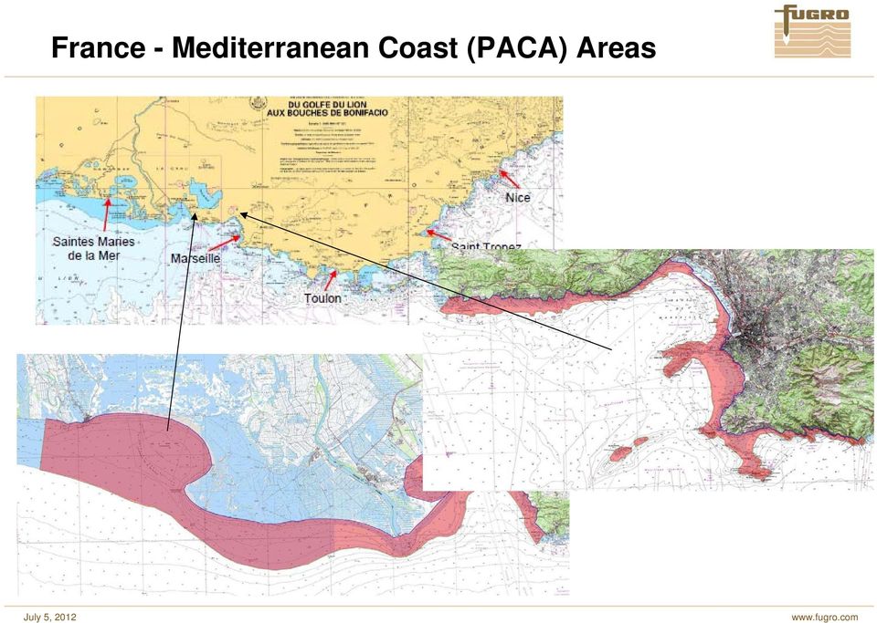
5 France - Mediterranean Coast (PACA) Areas
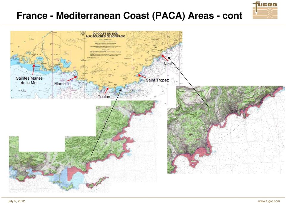
6 France - Mediterranean Coast (PACA) Areas - cont
7 Italian Marine Protected Park Survey Areas

8 2012 ALB surveys in France Survey is for regional and national agencies for a number of applications for which a precise understanding of the coastal bathymetry is required. Products to support: benthic habitat mapping for biodiversity risk prevention including tsunami modelling flood inundation mapping coastline management including erosion and sand nourishment economic development for ports tourism and scientific research

9 Challenges to be overcome Finistère France Finistère Survey Areas Sea and Swell conditions Cloud Kelp Black rocks Bright sands Up to 13m tides, and tidal streams

10 Finistère survey area - kelp growth Image AAMP - PNMI Belts of himanthallia (distribution between 0 and 3 m) in summer
")
11 Finistère survey area - kelp growth Image AAMP - PNMI Belts of laminaria digitata (distribution between 0 and 5 m) in summer
")
12 Finistère survey area - kelp growth Image AAMP - PNMI Belts of laminaria hyperborea (distribution between 10 and 30 m) in summer
")
13 Finistère survey area - kelp growth Image AAMP - PNMI Seabed vegetation strata in summer

14 Finistère survey area - kelp growth Image AAMP - PNMI Impact kelp may prevent seabed coverage if surveyed too late in the season

15 Challenges to be overcome PACA France ATC restrictions Some areas could only be worked between 0600 and 0800 Airport Restrictions All but Nice would only open after 0800! Commercial Activity 3 major airports in the area Private aircraft movements Cannes, Hyeres and St Tropez very busy Tourism restrictions Restricted weekend and summer work on beaches Boat movements!! Noise restrictions before 0800 High Ground Military Restricitons

16 France Survey Strategy Certain areas in Finistère need to be surveyed in winter / spring prior to kelp growth, however the weather is not always suitable, spring tides are no go! Certain areas of PACA are impacted by commercial activities in summer months. May ATC / Airport issues to be resolved. Alternative areas are assigned and planned for each flight in the event that conditions are not suitable in the primary area ALB surveys have the benefit of the operational flexibility of an aircraft to freely move within and between survey areas to avoid unsuitable environmental conditions Very high importance placed on very shallow water areas by customer.

17 France Survey Strategy - Technology Need a solution that was capable of Surveying approximately 2500 sqkm in a 5 month period Achieve 30m in Atlantic and Mediterranean areas Can move between the French Atlantic and Mediterranean coasts at short notice Able to maintain coverage in very dark seabed areas adjacent to very bright areas and deal with Kelp issues Able to obtain high density coverage in the critical shallow water areas Solution was New LADS Mk 3 New Riegl Vq820g CASA Aircraft

18 France Survey Strategy Survey Plan Start Finistère areas during Winter prior to the commencement of Kelp growth, maximising tidal opportunities Survey PACA coastline during periods of bad weather in Finistère Complete PACA in early summer prior to onset of Tourists

19 2012 ALB surveys in France Images AAMP - PNMI Winter storms leave massive kelp deposits stranded on beaches

20 2012 ALB surveys in France Survey was commenced in winter to avoid a particular problem on the seabed of the Atlantic coast of thick kelp State of the field of kelp in February Image AAMP - PNMI

21 Bathy LiDAR Solution General Capability Designed for safe and efficient shallow water survey to IHO Standards High coverage rate to a maximum depth of 80m dependant on water clarity IHO Order 1a or 1b surveys and Order 2 for very efficient wide swath mode Applications: hydrography, coastal zone management, environmental, engineering, exploration LADS Mk 3
22 How Airborne LiDAR Bathymetry Works Scanned green beam, reflects from the sea surface and the seabed, and is detected by the green receiver. Green pulses from the sea surface are used to create a sea surface model Green pulses from the seabed, are used to determine the depth of water, relative to the sea surface model or measured from the ellipsoid
23 Fugro LADS Technical Philosophy Design Philosophy The cornerstones of Fugro LADS technical design philosophy are based on maximising the quality of the data collected, a focus on hydrographic survey for Nautical Charting and refreshing the technology through a continual upgrade process Data Quality The Fugro LADS systems have been designed with an emphasis on data quality. This is based on collecting signals with the highest quality signal to noise ratio by: High laser power Wide aperture optical receiver Automatic gain control Good Depth Performance
24 Technological Solutions - Fugro LADS Mk 3 General Coastal and Deep water Bathymetric LiDAR system Key System Enhancements 1. Reduced size and weight installable in aircraft of opportunity 2. Faster laser, The system has been launched initially with a 1.5 KHz laser with room for expansion, without loss of laser power (currently testing 2kHz upgrade) 3. Improved physical and optical design of the transmit and receive sides of the system, through improvements to the optical coatings on mirrors, lenses and windows to improve the reflectivity and transmission degrees cross-track and roll compensation. 5. The system has depth performance of 80 metres (clear water conditions). 6. Wider swath widths and resolutions LADS Mk 3
25 What s new with Fugro LADS Mk 3 LADS technology in an aircraft of opportunity, maintaining high laser power, wide aperture receiver and automatic gain control Improved performance including greater depth capability, higher altitude operations and very wide swaths Continual upgrade process has provided improved target detection, shallow water performance and seabed reflectivity Integration of other sensors: high density LiDAR and VNIR hyperspectral Use of PPP and ellipsoidal datums Port Stephens Golfe du Lion NW Shelf WA
26 Introducing a new capability High density shallow water ALB and topographic data New RIEGL VQ-820-G shallow water airborne Laser scanner has just been developed by RIEGL RIEGL system has been integrated with LADS Mk 3 system in the same aircraft Both systems operate at 532nm LADS system scans under the aircraft, RIEGL is angles 20 degrees aft Systems complement each other providing coverage on the coast and offshore to deep water (LADS) and very high density coverage in very shallow water and on the beach and coast (RIEGL) LADS Mk 3 and RIEGL VQ-820-G mounted in CASA 212
27 Simultaneous Operations LADS Mk 3 forward looking rectilinear scan pattern Riegl Vq 820g set up to be a rear looking orbital scan Both operated simultaneously, no interference was observed
28 RIEGL VQ-820-G system Operated in 138kHz mode ~ 1.5 point / sq m on the ground & in the water, at typical ALB survey speed / operating height Depth measurement up to 10 metres observed Laser footprint size ~ 0.6m at typical ALB operating height Operated at 42 degree fov, scan ~ 20 degrees aft
29 Data collection Operations Set to Work Conducted in Parma, Italy 18 Jan 31 Jan Initial trials in Italy, then in Brest France Finistère Deployment 11 Feb to 31May Neap tides quickly became critical Cloud was a constant problem 48 Successful survey flights, 21 aborted due to environmental conditions South Finistère area unable to be completed Operating Base in Brest, Finistère Region PACA Unable to be conducted simultaneously with Finistère Flown 11 May to 31 June Bouches de Rhone area not completed due to Turbidity Operating Base in Hyere, Var Region
30 LADS and RIEGL Coverage (Interim data) Zone North Finistère
31 LADS and RIEGL Coverage (Interim data) Zone West Finistère - Sein
32 LADS and RIEGL Coverage (Interim data) Zone PACA - Marseille
33 LADS and RIEGL Coverage (Interim data) Zone West Finistère
34 RIEGL Coverage (Interim data) Ile de Batz (island NW coast of Finistère)
35 LADS Coverage (Interim data) Ile de Batz (island NW coast of Finistère)
36 LADS and RIEGL Coverage (Interim data) Ile de Batz (island NW coast of Finistère)
37 Complimentary Data Sets - Breakwater LADS Data Riegl Data Merged Data
38 Complimentary Data Sets Ile de Sein (West Finistère) Riegl Vq 820 Coverage
39 Complimentary Data Sets Ile de Sein (West Finistère) LADS Mk3 - Coverage
40 Complimentary Data Sets Ile de Sein (West Finistère) Merged Data Coverage
41 Thank You Nigel Townsend Survey and Operations Manager - Fugro LADS Corporation [email protected]
MSDI: Workflows, Software and Related Data Standards
 MSDI: Workflows, Software and Related Data Standards By Andy Hoggarth October 2009 Introduction Leveraging SDI principles for hydrographic operational efficiency French INFRAGEOS example (SHOM - Service
OPPORTUNITIES OF AIRBORNE LASER BATHYMETRY FOR THE MONITORING OF THE SEA BED ON THE BALTIC SEA COAST
 OPPORTUNITIES OF AIRBORNE LASER BATHYMETRY FOR THE MONITORING OF THE SEA BED ON THE BALTIC SEA COAST Joachim Niemeyer,a and Uwe Soergel b a Institute of Photogrammetry and GeoInformation, Leibniz Universität
'Developments and benefits of hydrographic surveying using multispectral imagery in the coastal zone
 Abstract With the recent launch of enhanced high-resolution commercial satellites, available imagery has improved from four-bands to eight-band multispectral. Simultaneously developments in remote sensing
Integration of LIDAR Data in CARIS HIPS for NOAA Charting Carol McKenzie *, Bill Gilmour, Lieutenant Edward J. Van Den Ameele, Mark Sinclair
 Integration of LIDAR Data in CARIS HIPS for NOAA Charting Carol McKenzie *, Bill Gilmour, Lieutenant Edward J. Van Den Ameele, Mark Sinclair * Carol McKenzie, Data Center Supervisor, Thales GeoSolutions
Improving Hydrographic Rate of Effort
 Improving Hydrographic Rate of Effort Presented by Scott Elson Australia s Surveying Responsibility Source: http://www.hydro.gov.au/business-publications/hydroscheme-2010-2012.pdf Company Proprietary 2
Shallow Water Swath Bathymetry from Small Platforms. Advances in Seafloor Mapping Sonar, 30 Dec 2009 Systems Engineering & Assessment Ltd.
 Shallow Water Swath Bathymetry from Small Platforms Advances in Seafloor Mapping Sonar, 30 Dec 2009 Systems Engineering & Assessment Ltd. Presentation Requirements, applications and challenges SWATHplus
The Integration of Hydrographic and Oceanographic Data in a Marine Geographic Information System U.S. Hydro 2015
 The Integration of Hydrographic and Oceanographic Data in a Marine Geographic Information System U.S. Hydro 2015 Karen Hart CARIS USA Oceanography and Hydrography Defined Oceanography: The branch of Earth
Outline. Application of AUVs for Hydrography. AUVs for hydrographic surveying AUV horizontal mapping accuracy
 Application of AUVs for Hydrography Øyvind Hegrenæs, Ph.D. AUV Department Outline AUVs for hydrographic surveying AUV horizontal mapping accuracy HUGIN 1000 with HISAS 1030 SAS HiPAP 500 USBL or GPS surface
Gravir Outer, Isle of Lewis Site and Hydrographic survey report
 Gravir Outer, Isle of Lewis Site and Hydrographic survey report November 2013 The Scottish Salmon Company 8 Melville Crescent Edinburgh EH3 7JA Report No: Issued By: Mathew Laughton Checked By: Mark Edmonds
Ocean Engineering, Surveying and Mapping Services
 Ocean Engineering, Surveying and Mapping Services FUGRO PELAGOS, INC. Fugro collects and interprets data related to the earth s surface and the soils and rocks beneath. It provides advice based on the
Contents. 1. PROFILE p2. 2. SERVICES 2.1 Offshore Support Services p 4 Offshore support p 6 ROV operations p 8
 OCTOBER 2013 22 Contents 1. PROFILE p2 2. SERVICES 2.1 Offshore Support Services p 4 Offshore support p 6 ROV operations p 8 2.2 Hydrographic & Geophysical services p 10 Bathymetric surveys p 12 High resolution
The use of Satellite Remote Sensing for Offshore Environmental Benchmarking
 The use of Satellite Remote Sensing for Offshore Environmental Benchmarking Michael King Fugro NPA Limited Fugro NPA (Formerly Nigel Press Associates) World leading Satellite Remote Sensing & Geoscience
STATUS REPORT FOR THE SUBMERGED REEF BALL TM ARTIFICIAL REEF SUBMERGED BREAKWATER BEACH STABILIZATION PROJECT FOR THE GRAND CAYMAN MARRIOTT HOTEL
 STATUS REPORT FOR THE SUBMERGED REEF BALL TM ARTIFICIAL REEF SUBMERGED BREAKWATER BEACH STABILIZATION PROJECT FOR THE GRAND CAYMAN MARRIOTT HOTEL performed by Lee E. Harris, Ph.D., P.E. Consulting Coastal
Hydrography at IHO cat A level: Scientific Education, at Sea Training, and Interaction with the Industry. N. Debese, R. Moitié, N.
 Hydrography at IHO cat A level: Scientific Education, at Sea Training, and Interaction with the Industry N. Debese, R. Moitié, N. Seube analysis CHC 2010-2 Located in Brest: takes benefits of the French
AirborneHydroMapping. New possibilities in bathymetric and topographic survey
 AirborneHydroMapping New possibilities in bathymetric and topographic survey AIRBORNE HYDROMAPPING (2008 2011) Layout needs from water engineering side: - Shallow water applications - High point density
16 th IOCCG Committee annual meeting. Plymouth, UK 15 17 February 2011. mission: Present status and near future
 16 th IOCCG Committee annual meeting Plymouth, UK 15 17 February 2011 The Meteor 3M Mt satellite mission: Present status and near future plans MISSION AIMS Satellites of the series METEOR M M are purposed
Satellite Derived Bathymetry
 11 th CSPWG MEETING 28 April, 2015 CSPCWG10-08.7A Submitted by: Executive Summary: Related Documents: Related Projects: Paper for Consideration by CSPCWG Satellite Derived Bathymetry UK CSPCWG is invited
Robot Perception Continued
 Robot Perception Continued 1 Visual Perception Visual Odometry Reconstruction Recognition CS 685 11 Range Sensing strategies Active range sensors Ultrasound Laser range sensor Slides adopted from Siegwart
УДК 528 Nguyen Thanh Le APPLYING MULTIBEAM ECHO-SOUNDER SYSTEM IN MAKING MULTISCALE SEABED TOPOGRAPHY MAP IN VIETNAM
 Новый университет. 2013. 11-12(21-22). ISSN 2221-9552 УДК 528 Nguyen Thanh Le APPLYING MULTIBEAM ECHO-SOUNDER SYSTEM IN MAKING MULTISCALE SEABED TOPOGRAPHY MAP IN VIETNAM Making multiscale seabed topography
Implementing Marine SDI Through Capacity Building
 Implementing Marine SDI Through Capacity Building A TopoBathy Database for Mozambique NIOHC Colombo, 20 th 23 rd March 2012 Fredericton Canada Heeswijk The Netherlands Washington DC United States Adelaide
RIEGL VQ-480. Airborne Laser Scanning. Airborne Laser Scanner with Online Waveform Processing. visit our website www.riegl.com
 Airborne Laser Scanner with Online Waveform Processing RIEGL VQ-48 high-accuracy ranging based on echo digitization and online waveform processing high laser repetition rate - fast data acquisition multiple
Creating a Seamless Model of the Littoral and Near Shore Environments
 Creating a Seamless Model of the Littoral and Near Shore Environments Peter Stewart and Peter Canter Applanix Corporation Abstract Ports and harbours have long utilized multibeam sonar to model the surface
RIEGL VZ-400 NEW. Laser Scanners. Latest News March 2009
 Latest News March 2009 NEW RIEGL VZ-400 Laser Scanners The following document details some of the excellent results acquired with the new RIEGL VZ-400 scanners, including: Time-optimised fine-scans The
ebb current, the velocity alternately increasing and decreasing without coming to
 Slack water (slack tide): The state of a tidal current when its velocity is near zero, especially the moment when a reversing current changes its direction and its velocity is zero. The term is also applied
Section E2 Coastal Engineering: Reconstruction Management and Mitigation
 271 Section E2 Coastal Engineering: Reconstruction Management and Mitigation 272 Objectives To familiarize the assessor with the process that should be followed in organizing any reconstruction efforts.
Fabrizio Tadina Regional Sales Manager Western Europe Airborne Products Optech Incorporated
 Fabrizio Tadina Regional Sales Manager Western Europe Airborne Products Optech Incorporated Airborne Trends Analysis Review of market pressures that are driving Optech development efforts Product Announcements
Hydrographic Surveying using High Resolution Satellite Images
 Hydrographic Surveying using High Resolution Satellite Images Petra PHILIPSON and Frida ANDERSSON, Sweden Key words: remote sensing, high resolution, hydrographic survey, depth estimation. SUMMARY The
LiDAR for vegetation applications
 LiDAR for vegetation applications UoL MSc Remote Sensing Dr Lewis [email protected] Introduction Introduction to LiDAR RS for vegetation Review instruments and observational concepts Discuss applications
Hydrography and the ACLS. Jean-Claude TÉTREAULT, Canada
 Jean-Claude TÉTREAULT, Canada SUMMARY The Association of Canada Lands Surveyors (ACLS) is the national licensing body for professionals surveying Canada Lands, which consist of the three territories, national
Developing Ocean Energy in Ireland. Belmullet Wave Energy Test Site
 Developing Ocean Energy in Ireland Belmullet Wave Energy Test Site Where does our energy come from? Most of the energy we use in Ireland comes from fossil fuels such as oil, coal, peat and gas. We burn
SHOALS Toolbox: Software to Support Visualization and Analysis of Large, High-Density Data Sets
 SHOALS Toolbox: Software to Support Visualization and Analysis of Large, High-Density Data Sets by Jennifer M. Wozencraft, W. Jeff Lillycrop, and Nicholas C. Kraus PURPOSE: The Coastal and Hydraulics Engineering
Applications of Integrated Vessel-based LiDAR, Multibeam Bathymetry, and Geophysical Surveys for Geohazard Assessments and Site Characterization
 Applications of Integrated Vessel-based LiDAR, Multibeam Bathymetry, and Geophysical Surveys for Geohazard Assessments and Site Characterization James Fisher Engineering Geologist Todd Mitchell Survey
Lidar 101: Intro to Lidar. Jason Stoker USGS EROS / SAIC
 Lidar 101: Intro to Lidar Jason Stoker USGS EROS / SAIC Lidar Light Detection and Ranging Laser altimetry ALTM (Airborne laser terrain mapping) Airborne laser scanning Lidar Laser IMU (INS) GPS Scanning
1.0 INTRODUCTION 2.0 SCOPE OF WORK. DATE July 29, 2010 PROJECT No. 09-1436-5008/2000
 DATE July 29, 2010 PROJECT No. 09-1436-5008/2000 TO Geoff Sinnett Ministry of Agriculture and Lands, Crown Land Restoration Branch cc Dawn Flotten FROM Karl Manzer EMAIL [email protected] LADYSMITH HARBOUR
High Resolution RF Analysis: The Benefits of Lidar Terrain & Clutter Datasets
 0 High Resolution RF Analysis: The Benefits of Lidar Terrain & Clutter Datasets January 15, 2014 Martin Rais 1 High Resolution Terrain & Clutter Datasets: Why Lidar? There are myriad methods, techniques
The Hong Kong Polytechnic University. Subject Description Form
 The Hong Kong Polytechnic University Subject Description Form Subject Code Subject Title LSGI3350A Hydrographic Surveying Credit Value 3 Level 3 Pre-requisite / Co-requisite/ Exclusion Objectives Nil This
Managing Bathymetry in the Cloud with GIS
 Esri Maritime Professional Services GEBCO Science Day Tuesday, October 4, 2011 Managing Bathymetry in the Cloud with GIS Timothy Kearns & Beata Van Esch Overview The challenges of bathymetry in GIS - What
Active and Passive Microwave Remote Sensing
 Active and Passive Microwave Remote Sensing Passive remote sensing system record EMR that was reflected (e.g., blue, green, red, and near IR) or emitted (e.g., thermal IR) from the surface of the Earth.
Bathymetry Acquisition - Technologies and Strategies
 Bathymetry Acquisition - Technologies and Strategies Investigating shallow water bathymetry acquisition technologies, survey considerations and strategies N. D. Quadros Report prepared for the Commonwealth
THE BRIEF FOR THE PROVISION OF SWATH BATHYMETRY TO IHO ORDER 1A
 THE BRIEF FOR THE PROVISION OF SWATH BATHYMETRY TO IHO ORDER 1A Scheme Title Employer s Address Nominated Employer s Representative Survey Title Purpose of Survey Specification Northeast Regional Coastal
Full Waveform Digitizing, Dual Channel Airborne LiDAR Scanning System for Ultra Wide Area Mapping
 Full Waveform Digitizing, Dual Channel Airborne LiDAR Scanning System for Ultra Wide Area Mapping RIEGL LMS-Q56 high laser pulse repetition rate up to 8 khz digitization electronics for full waveform data
Coastal Erosion Risk Mitigation Strategies applied in a Small Island Developing State: The Barbados Model
 Coastal Erosion Risk Mitigation Strategies applied in a Small Island Developing State: The Barbados Model BY Dr. Leo Brewster, Director Coastal Zone Management Unit, Barbados Presented At UNFCCC Expert
INTEGRATED GEOPHYSICAL AND REMOTE SENSING STUDIES ON GROTTA GIGANTE SHOW CAVE (TRIESTE ITALY) P. Paganini, A. Pavan, F. Coren, A.
 P. Paganini, A. Pavan, F. Coren, A.") INTEGRATED GEOPHYSICAL AND REMOTE SENSING STUDIES ON GROTTA GIGANTE SHOW CAVE (TRIESTE ITALY) P. Paganini, A. Pavan, F. Coren, A. Fabbricatore Aerial lidar survey - strumentation Piper Seneca II - PA34
INTEGRATED GEOPHYSICAL AND REMOTE SENSING STUDIES ON GROTTA GIGANTE SHOW CAVE (TRIESTE ITALY) P. Paganini, A. Pavan, F. Coren, A. Fabbricatore Aerial lidar survey - strumentation Piper Seneca II - PA34
Hyperspectral Satellite Imaging Planning a Mission
 Hyperspectral Satellite Imaging Planning a Mission Victor Gardner University of Maryland 2007 AIAA Region 1 Mid-Atlantic Student Conference National Institute of Aerospace, Langley, VA Outline Objective
A Case Study Documenting the Dubai Coastal Zone Monitoring Programme An International Example.
 A Case Study Documenting the Dubai Coastal Zone Monitoring Programme An International Example. prepared in the framework of the MESSINA project December 2005 Project part-financed by the European Union
Chapter Overview. Bathymetry. Measuring Bathymetry. Echo Sounding Record. Measuring Bathymetry. CHAPTER 3 Marine Provinces
 Chapter Overview CHAPTER 3 Marine Provinces The study of bathymetry charts ocean depths and ocean floor topography. Echo sounding and satellites are efficient bathymetric tools. Most ocean floor features
Predicting Coastal Hazards: A Southern California Demonstration
 Predicting Coastal Hazards: A Southern California Demonstration Patrick Barnard United States Geological Survey Coastal and Marine Geology Team Santa Cruz, CA Southern California Multi-hazards Demonstration
The optimum offshore survey workflow for high-quality GIS results. by integrating CARIS & EIVA software
 The optimum offshore survey workflow for high-quality GIS results by integrating CARIS & EIVA software As a result of a unique and dedicated partnership, CARIS and EIVA offer the optimum solution for offshore
Martin County Coastal GIS Program St Lucie Inlet Planning Tool
 Martin County Coastal GIS Program St Lucie Inlet Planning Tool Alexandra Carvalho, Ph.D., GISP Kathy Fitzpatrick, P.E. Jessica Garland Martin County, Florida Presentation Overview County Coastal Programs
POSITION DESCRIPTION 1 PURPOSE OF POSITION
 POSITION DESCRIPTION Position Title: Senior Hydrographic Surveyor Division: Operations Section: Survey Position Title of Supervisor: Executive Manager Operations 1 PURPOSE OF POSITION Responsible for the
SUBSIDIARY LEGISLATION WILDLIFE & PROTECTED AREAS. Marine Protected Areas Order 2012. S. R. & O. No: 1 of 2012
 SUBSIDIARY LEGISLATION WILDLIFE & PROTECTED AREAS Marine Protected Areas Order 2012 S. R. & O. No: 1 of 2012 Made: 23 February 2012 Published: 29 February 2012 Coming into force: on publication IN EXERCISE
IHO STANDARDS FOR HYDROGRAPHIC SURVEYS
 INTERNATIONAL HYDROGRAPHIC ORGANIZATION IHO STANDARDS FOR HYDROGRAPHIC SURVEYS 5 th Edition, February 2008 Special Publication No. 44 Published by the International Hydrographic Bureau MONACO INTERNATIONAL
LIDAR and Digital Elevation Data
 LIDAR and Digital Elevation Data Light Detection and Ranging (LIDAR) is being used by the North Carolina Floodplain Mapping Program to generate digital elevation data. These highly accurate topographic
REGIONAL SEDIMENT MANAGEMENT: A GIS APPROACH TO SPATIAL DATA ANALYSIS. Lynn Copeland Hardegree, Jennifer M. Wozencraft 1, Rose Dopsovic 2 INTRODUCTION
 REGIONAL SEDIMENT MANAGEMENT: A GIS APPROACH TO SPATIAL DATA ANALYSIS Lynn Copeland Hardegree, Jennifer M. Wozencraft 1, Rose Dopsovic 2 ABSTRACT: Regional sediment management (RSM) requires the capability
Australian Hydrographic Service Charting the Australian waters near and far
 Australian Hydrographic Service Charting the Australian waters near and far L Pietrini Australian Hydrographic Service, Wollongong, NSW Abstract The Australian Hydrographic Service (AHS) collects, manages
Promotion of Satellite Derived Bathymetry (SDB) & other Satellite Remote Sensing EO downstream services for the marine economy
 & other Satellite Remote Sensing EO downstream services for the marine economy") Promotion of Satellite Derived Bathymetry (SDB) & other Satellite Remote Sensing EO downstream services for the marine economy François Régis Martin Lauzer, chairman of ARGANS Ltd with contributions of
Promotion of Satellite Derived Bathymetry (SDB) & other Satellite Remote Sensing EO downstream services for the marine economy François Régis Martin Lauzer, chairman of ARGANS Ltd with contributions of
TopoBathy Database Mozambique
 TopoBathy Database Mozambique Andrew Hoggarth, (Canada), Gordon Johnston (UK) Charles de Jongh and peter Schwarzberg (Netherlands) Montevideo Uruguay, 28 th November 2012 Fredericton Canada Heeswijk The
BEACH NOURISHMENT COMBINED WITH SIC VERTICAL DRAIN IN MALAYSIA.
 BEACH NOURISHMENT COMBINED WITH SIC VERTICAL DRAIN IN MALAYSIA. Claus Brøgger 1 and Poul Jakobsen 2 The present paper presents measurements and results from a three year full scale Pilot Project with the
Storm tide is the water level rise during a storm due to the combination of storm surge and the astronomical tide.
 INTRODUCTION TO STORM SURGE Introduction to Storm Surge BOLIVAR PENINSULA IN TEXAS AFTER HURRICANE IKE (2008) What is Storm Surge? Inland Extent Storm surge can penetrate well inland from the coastline.
HYDROGRAPHIC DEPARTMENT MARITIME AND PORT AUTHORITY OF SINGAPORE (MPA) (Version: July 2015)
 (Version: July 2015)") HYDROGRAPHIC DEPARTMENT MARITIME AND PORT AUTHORITY OF SINGAPORE (MPA) (Version: July 2015) GENERAL SPECIFICATIONS FOR THE CONDUCT OF HYDROGRAPHIC SURVEYS 1 Engagement of Commercial Hydrographic Surveyor
HYDROGRAPHIC DEPARTMENT MARITIME AND PORT AUTHORITY OF SINGAPORE (MPA) (Version: July 2015) GENERAL SPECIFICATIONS FOR THE CONDUCT OF HYDROGRAPHIC SURVEYS 1 Engagement of Commercial Hydrographic Surveyor
Final Project Report
 CURTIN UNIVERSITY OF TECHNOLOGY Department of Applied Geology Western Australia School of Mines Applied Sedimentology, Coastal and Marine Geoscience Group GERALDTON EMBAYMENTS COASTAL SEDIMENT BUDGET STUDY
HV Submarine Cable Systems Design, Testing and Installation
 HV Submarine Cable Systems Design, Testing and Installation CIGRE Ireland Technical Seminar 6 th October 2010 Robert Donaghy Senior Consultant Engineer, ESB International Presentation Overview Applications
Storm tide is the water level rise during a storm due to the combination of storm surge and the astronomical tide.
 INTRODUCTION TO STORM SURGE Introduction to Storm Surge National Hurricane Center Storm Surge Unit BOLIVAR PENINSULA IN TEXAS AFTER HURRICANE IKE (2008) What is Storm Surge? Inland Extent Storm surge can
Using LIDAR to monitor beach changes: Goochs Beach, Kennebunk, Maine
 Geologic Site of the Month February, 2010 Using LIDAR to monitor beach changes: Goochs Beach, Kennebunk, Maine 43 o 20 51.31 N, 70 o 28 54.18 W Text by Peter Slovinsky, Department of Agriculture, Conservation
THE ROLE OF BATHYMETRY IN INTERNATIONAL MARITIME LAW AND IN THE PROVISIONS OF THE UN CONVENTION ON THE LAW OF THE SEA By NEIL GUY.
 Charting the Secret World of the Ocean Floor. The GEBCO Project 1903-2003 1 THE ROLE OF BATHYMETRY IN INTERNATIONAL MARITIME LAW AND IN THE PROVISIONS OF THE UN CONVENTION ON THE LAW OF THE SEA By NEIL
ABSTRACT INTRODUCTION PURPOSE
 EVALUATION OF TSUNAMI DISASTER BY THE 2011 OFF THE PACIFIC COAST OF TOHOKU EARTHQUAKE IN JAPAN BY USING TIME SERIES SATELLITE IMAGES WITH MULTI RESOLUTION Hideki Hashiba Associate Professor Department
MI oceanographic data
 Marine Institute Oceanographic Data SMARTSkills 2013 Postgraduate Workshop Galway, Oct 2013 Kieran Lyons ([email protected]) MI oceanographic data Measured Operational metocean time series (weather
An Initial Assessment of the Impacts of Sea Level Rise to the California Coast
 An Initial Assessment of the Impacts of Sea Level Rise to the California Coast Photo by D. Revell 2/23/08 California Coastal Records Project Dr. David Revell and Matt Heberger, P.E. Dr. Peter Gleick, Bob
Addendum for compatible Navico MFD s that support the following Broadband 4G Radar features:
 Addendum for compatible Navico MFD s that support the following Broadband 4G Radar features: Dual Radar Dual Range 4G Radar Controls -Target - Separation -Noise - Rejection -Fast - Scan Directional Clutter
(1) define the objectives and intended use of the maps and spatial data and
 define the objectives and intended use of the maps and spatial data and") Mapping coastal seabed habitats in Tasmania: development and integration of remote sensing techniques within a hierarchical framework Alan Jordan Vanessa Halley Miles Lawler Richard Mount Project Planning
Mapping coastal seabed habitats in Tasmania: development and integration of remote sensing techniques within a hierarchical framework Alan Jordan Vanessa Halley Miles Lawler Richard Mount Project Planning
RESTORATION AND ENHANCEMENT OF SOUTHERN CALIFORNIA LAGOONS
 RESTORATION AND ENHANCEMENT OF SOUTHERN CALIFORNIA LAGOONS by Hany Elwany, Ph.D. Scripps Institution of Oceanography Headwaters to Oceans Conference 25 October 2003 CE Ref #03-22 San Diego County Lagoons
Survey Sensors Hydrofest 2014. Ross Leitch Project Surveyor
 Survey Sensors Hydrofest 2014 Ross Leitch Project Surveyor Satellite Positioning Only provides position of antenna Acoustic Positioning Only provides position of transponder relative to transceiver How
Real-time Ocean Forecasting Needs at NCEP National Weather Service
 Real-time Ocean Forecasting Needs at NCEP National Weather Service D.B. Rao NCEP Environmental Modeling Center December, 2005 HYCOM Annual Meeting, Miami, FL COMMERCE ENVIRONMENT STATE/LOCAL PLANNING HEALTH
Hurricanes and Storm Surge www.hcfcd.org/tropicalweather
 Hurricanes and Storm Surge www.hcfcd.org High-level winds fl ow outward Strong surface winds spiral inward EYE Calm, sometimes cloudfree, sinking air Air sinks in calm area at the storm s eye THUNDERSTORMS
How To Make An Orthophoto
 ISSUE 2 SEPTEMBER 2014 TSA Endorsed by: CLIENT GUIDE TO DIGITAL ORTHO- PHOTOGRAPHY The Survey Association s Client Guides are primarily aimed at other professionals such as engineers, architects, planners
Coastal Engineering Indices to Inform Regional Management
 Coastal Engineering Indices to Inform Regional Management Lauren Dunkin FSBPA 14 February 2013 Outline Program overview Standard products Coastal Engineering Index Conclusion and future work US Army Corps
2.3 Spatial Resolution, Pixel Size, and Scale
 Section 2.3 Spatial Resolution, Pixel Size, and Scale Page 39 2.3 Spatial Resolution, Pixel Size, and Scale For some remote sensing instruments, the distance between the target being imaged and the platform,
Passenger Terminal Amsterdam
 Fact sheet large cruise ships to Passenger Terminal Amsterdam Port of Amsterdam Amsterdam-IJmond Pilot Organization 2009 Version: November 6 th 2009 This fact sheet provides information on the passage
Resolutions of Remote Sensing
 Resolutions of Remote Sensing 1. Spatial (what area and how detailed) 2. Spectral (what colors bands) 3. Temporal (time of day/season/year) 4. Radiometric (color depth) Spatial Resolution describes how
Ariana Sutton-Grier, Holly Bamford & Kateryna Wowk University of Maryland and National Oceanic and Atmospheric Administration
 Future of our coasts: Potential for natural and hybrid infrastructure Ariana Sutton-Grier, Holly Bamford & Kateryna Wowk University of Maryland and National Oceanic and Atmospheric Administration Green
Observing and Monitoring the Visitor Use in Marine Protected Areas 1
 Observing and Monitoring the Visitor Use in Marine Protected Areas 1 Tourism as an opportunity Tourism is a source of employment and foreign currencies, and greatly contributes to economic development
PDF Created with deskpdf PDF Writer - Trial :: http://www.docudesk.com
 CCTV Lens Calculator For a quick 1/3" CCD Camera you can work out the lens required using this simple method: Distance from object multiplied by 4.8, divided by horizontal or vertical area equals the lens
Scanning laser mapping of the coastal zone: the SHOALS system
 Ž. ISPRS Journal of Photogrammetry & Remote Sensing 54 1999 123 129 Scanning laser mapping of the coastal zone: the SHOALS system Jennifer L. Irish ), W. Jeff Lillycrop JALBTCX, US Army Engineer District-Mobile
Joint Polar Satellite System (JPSS)
") Joint Polar Satellite System (JPSS) John Furgerson, User Liaison Joint Polar Satellite System National Environmental Satellite, Data, and Information Service National Oceanic and Atmospheric Administration
Joint Polar Satellite System (JPSS) John Furgerson, User Liaison Joint Polar Satellite System National Environmental Satellite, Data, and Information Service National Oceanic and Atmospheric Administration
Overview of Submarine Cable Route Planning & Cable Route Survey Activities. Graham Evans Director EGS Survey Group www.egssurvey.
 Overview of Submarine Cable Route Planning & Cable Route Survey Activities Graham Evans Director EGS Survey Group www.egssurvey.com Presentation Summary Submarine cable systems concept to reality Objectives
Harmonizing Survey Deliverables Emerging Standards and Smart Data Exchange
 Harmonizing Survey Deliverables Emerging Standards and Smart Data Exchange Andy Hoggarth and Karen Cove, CARIS, Fredericton, Canada Introduction When a survey company plans a project the deliverables are
Monitoring of Arctic Conditions from a Virtual Constellation of Synthetic Aperture Radar Satellites
 DISTRIBUTION STATEMENT A. Approved for public release; distribution is unlimited. Monitoring of Arctic Conditions from a Virtual Constellation of Synthetic Aperture Radar Satellites Hans C. Graber RSMAS
Air Traffic Management Services Plan 2012-2017
 Air Traffic Management Services Plan 2012-2017 Airservices Australia 2012 This work is copyright. Apart from any use as permitted under the Copyright Act 1968, no part may be reproduced by any process
Precision Hydrographic Services. Company Profile. Company Profile. We do it once, we do it right.
 Precision Hydrographic Services Company Profile 2015 Company Profile We do it once, we do it right. About Us Overview Precision Hydrographic Services (PHS) commenced in 2008 and specialise in the acquisition,
GEOScaN Remote Data Acquisition for Hydrographic, Topographic and GIS Surveying
 GEOScaN Remote Data Acquisition for Hydrographic, Topographic and GIS Surveying Laurence WATERHOUSE, United Kingdom Key words: remote sensing, hydrographic, laser scanning, GIS SUMMARY British Waterways
NATIONAL REPORT TO THE MEDITERRANEAN AND BLACK SEAS HYDROGRAPHIC COMMISSION (MBSHC) (Tunisia Tunisie)
 (Tunisia Tunisie)") NATIONAL REPORT TO THE MEDITERRANEAN AND BLACK SEAS HYDROGRAPHIC COMMISSION (MBSHC) (Tunisia Tunisie) 1. Hydrographic Office / Service: The Tunisian Hydrographic and Oceanographic Service has changed its
NATIONAL REPORT TO THE MEDITERRANEAN AND BLACK SEAS HYDROGRAPHIC COMMISSION (MBSHC) (Tunisia Tunisie) 1. Hydrographic Office / Service: The Tunisian Hydrographic and Oceanographic Service has changed its
Good Practice for Hydrographic Surveys in New Zealand Ports and Harbours. Maritime Safety MARITIME SAFETY AUTHORITY OF NEW ZEALAND Kia Maanu Kia Ora
 FINAL GUIDELINES OF Good Practice for Hydrographic Surveys in New Zealand Ports and Harbours KEEPING YOUR SEA SAFE FOR LIFE Maritime Safety MARITIME SAFETY AUTHORITY OF NEW ZEALAND Kia Maanu Kia Ora Disclaimer:
New Brunswick s Flood Risk Reduction Strategy. Province of New Brunswick PO 6000, Fredericton NB E3B 5H1. www.gnb.ca
 New Brunswick s Flood Risk Reduction Strategy i New Brunswick s Flood Risk Reduction Strategy Province of New Brunswick PO 6000, Fredericton NB E3B 5H1 2014 www.gnb.ca ISBN 978-1-4605-0533-5 (print edition)
HYDROGRAPHIC ECHOSOUNDER FOR SOUNDING INLAND WATERS ANDRZEJ JEDEL, LECH KILIAN, JACEK MARSZAL, ZAWISZA OSTROWSKI, ZBIGNIEW WOJAN, KRZYSZTOF ZACHARIASZ
 HYDROGRAPHIC ECHOSOUNDER FOR SOUNDING INLAND WATERS ANDRZEJ JEDEL, LECH KILIAN, JACEK MARSZAL, ZAWISZA OSTROWSKI, ZBIGNIEW WOJAN, KRZYSZTOF ZACHARIASZ Gdańsk University of Technology, Faculty of Electronics,
BOTTOM TRACKING ISSUES AND RECOGNITION THEREOF USING SHOALS-3000 GREEN LASER BEAM IN DENSE FIELDS OF ZOSTERA MARINA AND LAMINARIA SP.
 BOTTOM TRACKING ISSUES AND RECOGNITION THEREOF USING SHOALS-3000 GREEN LASER BEAM IN DENSE FIELDS OF ZOSTERA MARINA AND LAMINARIA SP. by Pim Kuus Bachelor of Maritime Operations, Maritiem Instituut Willem
Aquaculture Monitoring Standard
 Aquaculture Monitoring Standard Fisheries and Oceans Canada Date modified: 2015-07-22 Table of Contents Introduction 3 Definitions 3 I. Survey for Baseline Information [AAR section 8] 4 Predicted Contours