Fabrizio Tadina Regional Sales Manager Western Europe Airborne Products Optech Incorporated
|
|
|
- Violet Hudson
- 7 years ago
- Views:
Transcription
1 Fabrizio Tadina Regional Sales Manager Western Europe Airborne Products Optech Incorporated

2 Airborne Trends Analysis Review of market pressures that are driving Optech development efforts Product Announcements


3 Market Reports and Trends

4 Market Reports and Trends Therefore to ensure future PROFIT, clients must : 1. Improve Quality (precision and accuracy) 2. Improve Efficiency (collection and processing) 3. Increase Density (more points) 4. Add Value (metadata and developed products) 5. Purchase Assets at Reduced Cost (costs for sensors decreasing)
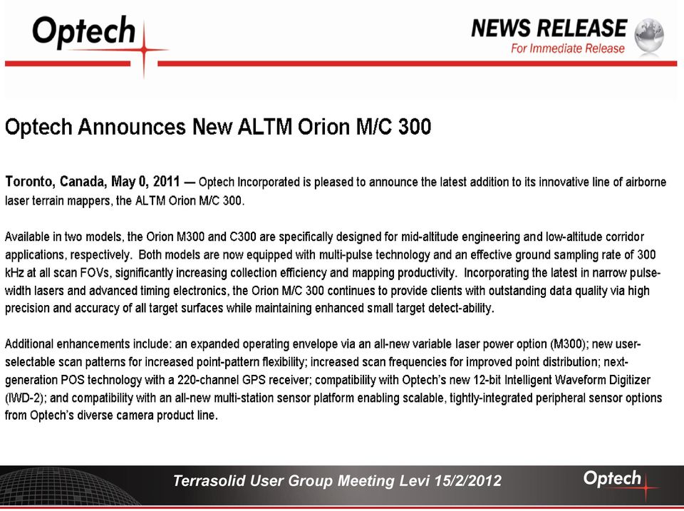
 4.")
5 Product Announcements in Support of Marketing Goals Release Status GSI Cameras Acquisition Pegasus HD 500 New 12-bit waveform digitizer New ALTM Aquarius Orion M/C 300 Orion configurable imaging platform Solid State Disk (SSD) storage Optech LMS v. 2.1 Optech FMS ASPRS, 2011 ILMF, 2011 ILSC, 2011 ILSC, 2011 InterGEO, 2011 InterGEO, 2011 InterGEO, 2011 ELMF Nov, 2011 ILMF, 2012

6

7
8
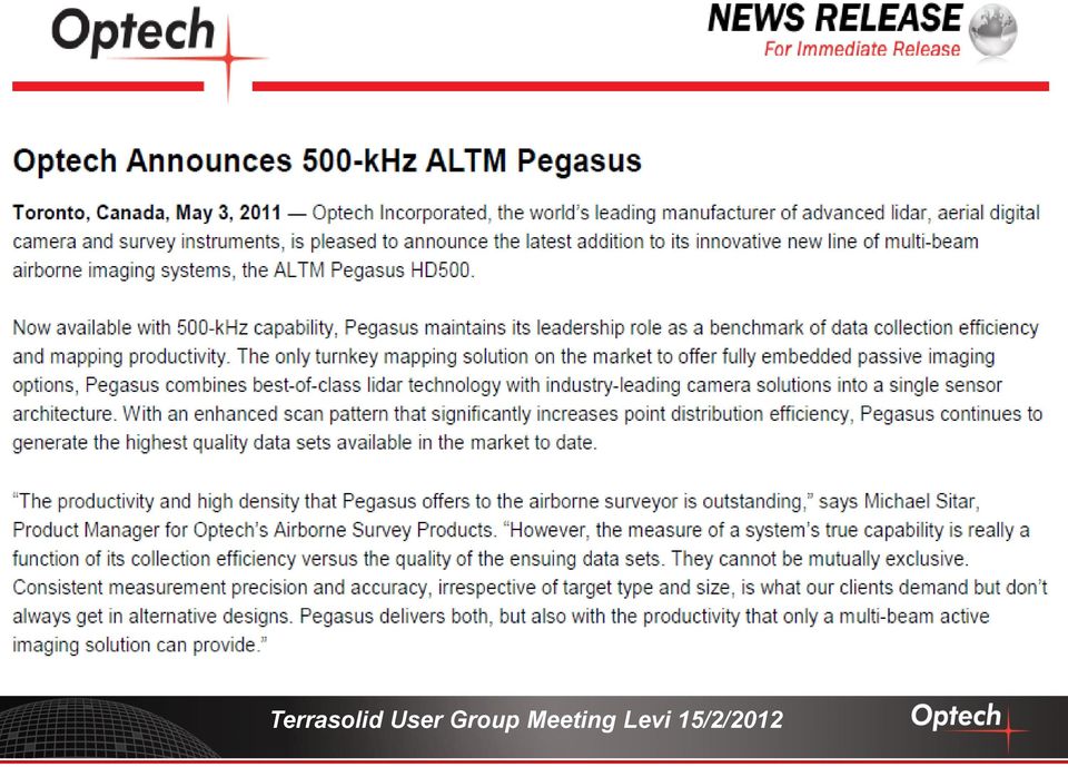
9 ALTM Pegasus

10 ALTM Pegasus - HD500 Value Proposition High-efficiency mapping system capable of high-density data sets at speed. Embedded passive imaging sensors add value with additional map product deliverables and meta data. Features/Benefits High efficiency in collection (multi-laser) High accuracy and precision (powerful, narrow pulse-width lasers and state-of-the-art timing electronics) Higher effective scan rates (scan rate x 2) Drop-in sensor design (unrestricted FOV) Embedded camera options (purpose-designed passive/active imaging solution) Upgraded Performance Increased laser rates (500 khz capable) Waveform digitizer compatible(12 bit) Multipulse capable (extended altitude and collection efficiency) New scan pattern for improved point distribution Additional scan patterns (sine) Solid State Disk storage Automated lidar rectification via Optech LMS (consistent project-wide accuracy; absolute/relative accuracy analysis)
 Drop-in sensor design (unrestricted FOV) Embedded camera options (purpose-designed passive/active imaging solution) Upgraded Performance Increased laser rates (500 khz capable)")
11 Combining Pegasus point clouds - 2 data streams Data co-registration a critical requirement

12
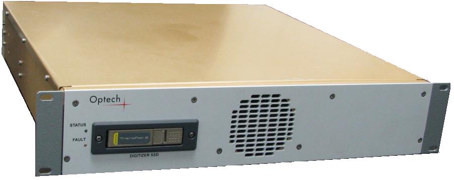
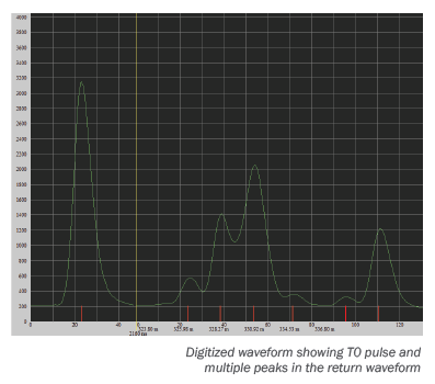
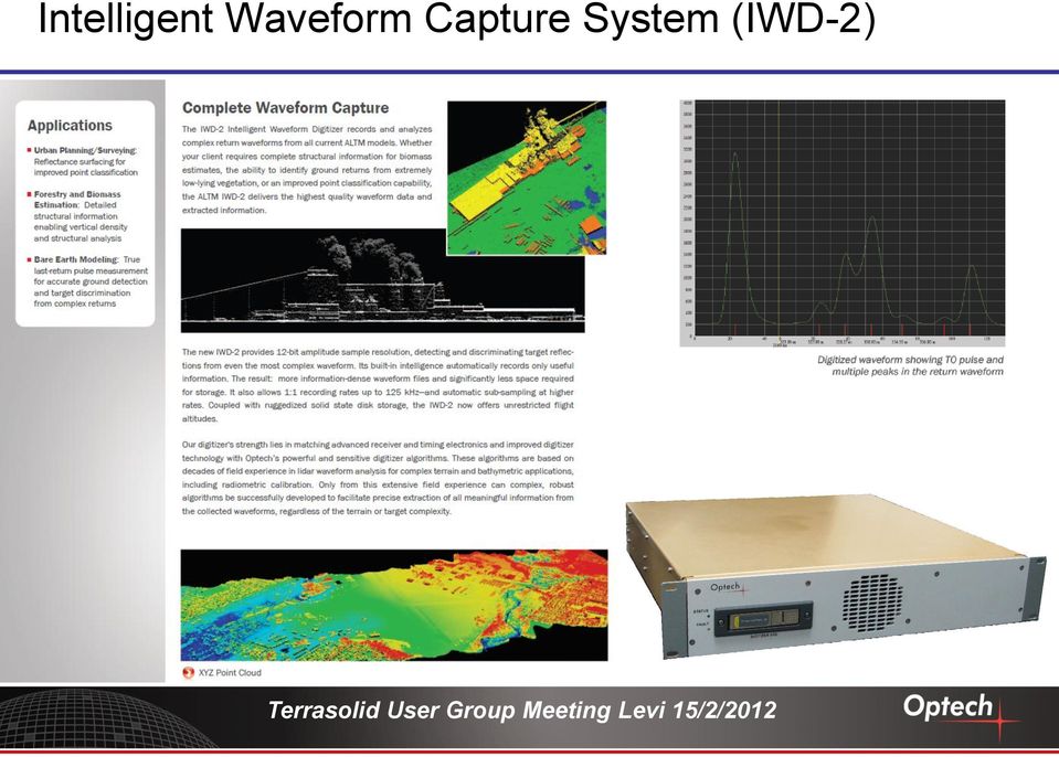
13 Intelligent Waveform Capture System (IWD-2)

;")
14 Optech LMS Lidar Mapping Suite Features/Benefits High-efficiency production processing suite Performance enhancements: parallel, distributed, batch, multi-sensor, multi-mission Automated lidar rectification Accuracy analysis: pre/post rectification, relative/absolute, graphs/plots/rooflines/reports Coordinate conversion Now Pegasus compatible (September 2011); LYNX Boresight (Summer 2012)
;")


15 ALTM Orion

16
17 ALTM Orion M/C 300 Value Proposition Ultra-compact, full mapping solution with industry-leading data precision and accuracy. Modular components and direct upgrade options enable scalable capability for maximum flexibility and application. Features/Benefits Compact form factor and low power requirements (smaller platform options) Industry-leading data precision (highest quality data sets possible) Production-focused workflow (processing efficiency) Programmable density irrespective of altitude Automated lidar rectification (no 3 rd party software required) Internal/external data storage options (storage flexibility) Multiple camera options (industry-leading passive imaging peripheral options) Upgraded Performance 300 khz effective ground sample rate MultiPulse: increased collection efficiency Increased scan frequency: 90 Hz Alternative scan patterns: Saw tooth and sinusoidal Variable Laser Power (VLP): Increased operational envelope at low altitude Waveform digitizer compatible (12 bit)
 Programmable density irrespective of altitude Automated lidar rectification (no 3 rd party software required) Internal/external data storage options (storage flexibility)")
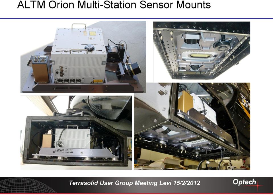
18 ALTM Orion Multi-Station Sensor Mount Add capability as required quickly and easily, without the hassles of further mount and aircraft modifications. Custom off-the-shelf sensor suites differentiate you from your competitors using scalable, tightly-integrated, peripheral sensor options via Optech s diverse camera product line. Features/Benefits Kinematic mounting system Enables the rapid removal and re-installation of cameras without affecting boresight accuracy Adapter Plate System Enables any combination of Optech cameras, camera shutter controllers and IMUs for maximum flexibility, scalability and configuration options Removable Vibration Dampening System Tuned for either aircraft or helicopter installations Quickly and easily detaches for rapid re-deployment of the sensor bed to alternative platforms, without affecting the system boresight accuracy.

19 ALTM Orion Multi-Station Sensor Mounts
20 ALTM Orion 2-Station Mount Aircraft mount accommodates: T-7200/4800/MS (1) centered to lidar FOV for small sensor portals T-7200/4800/MS (1) + external IMU T-7200 (1) + T-MS/4800 (1) D-8900 (1) + shutter controller box
 + T-MS/4800 (1) D-8900 (1) + shutter")
21 ALTM Orion 4-Station Mount Pod mount accommodates: T-7200(2) /MS (1) + external IMU T-7200 (1) + T-MS/4800 (2) + external IMU T-7200/4800/MS (1) + oblique T4800 (1) + external IMU D-8900 (2) + shutter controller box (2) D-8900 (1) + shutter controller box (1) /MS (1) + external IMU D-8900 (1) + shutter controller box (1) /MS (2) T-7200/4800/MS (2) + oblique T4800 (1)
22 4 - Station Commercial Mount
23 ALTM Solid State Disk Storage Compact (2.5 ) Sata SSD disks Fully ruggedized, locking drives designed for the airborne environment Status LEDS for write success and fault detection Multi-drive, compact download station supports USB and esata Standardized across all ALTM products (Orion, Pegasus, Gemini, IWD-2, DGX Camera)
24 Optech Flight Management System (FMS) Value Proposition Fully featured flight management system that seamlessly integrates planning, control, monitoring and navigation of Optech s wide selection of active/passive imaging sensors. Built on a robust data display engine, accurate realtime point cloud and imaging sensor data enhances collection confidence. Realtime lidar point display for true coverage capability Realtime LAS point file capture for rapid response applications (decimated and full resolution) Sensor planning and control; or fully integrated planning and control of up to 6 sensors Formal release expected in early 2012

25
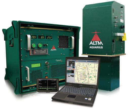
26 The Foundation of ALTM Aquarius System ALTM Gemini System with Aquarius Sensor head
27 Top-level Objectives The Aquarius sensor was initially developed to add bathymetric capability to ALTM Gemini. Green laser to penetrate through water (532 nm) Compatible with existing ALTM Gemini control rack Optional strapdown waveform digitizer for full bathymetric capability Same mechanical footprint as Gemini sensor head to facilitate rapid installation Similar data processing workflow
28 Workflow Considerations Same workflow for survey planning and data processing ALTM-NAV Flight Management Software DASHMap lidar processing software for XYZI data output Digitizer Data Retrieval (DDR) software for downloading and visualizing waveforms Current and future developments for data processing AquaDX software currently under development to incorporate bathymetric functionality Future development will incorporate Aquarius data processing into Optech s Lidar Mapping Suite (LMS) software
29 Aquarius Flight Testing, Pickering, Ontario Ground elevation accuracy analysis (GCP control site) Water depth accuracy analysis (SHOALS ground truth site) Depth penetration tests Lake Ontario
30 ALTM Aquarius depth penetration capability Aquarius flown land to water to measure maximum depth penetration capability. Flown using discreet timing electronics only (no waveform digitization for this specific test) Sonar GCP site Depth extinction tests
31 ALTM Aquarius depth penetration capability Maximum depth is ~12 m (corrected using index of refraction for water )
32 ALTM Aquarius measurement surfaces: water surface removed Land/water interface Underwater feature (trench)

33 Aquarius Elevation Point Cloud (includes waveform extracted water depths) 33

34 Elevation Profile Elevation profile illustrating simultaneous data acquisition of land and water depth information land/water transition Elevation profile water surface 34
35 Image overlay in Google Earth 35
36
37 Lynx M1
38 Lynx M1 Field of view: 360 Measurement Speed: Up to 500kHz per sensor, programmable Scanner speed: Hz programmable Simultaneous multiple return collection: 4 returns Eye safety: Class 1 iflex: Most advanced electronics ever
39 LMS / Lynx Survey Facilitates the planning of surveys Real time interface with operator and system Google Earth support On-the-fly data display Real time system control Integrates Open Street Map, geodetic conversion Maximizes processing efficiency
40
41 Nice June
42
Leica WDM65 Waveform Digitizer Module Product Specifications
 Waveform Digitizer Module OVERVIEW The Leica WDM65 is a Full Waveform Digitizing (FWD) module designed specifically for use with ALS50-II and ALS60 Airborne Laser Scanners. It records the complete waveform
IP-S2 HD. High Definition 3D Mobile Mapping System
 IP-S2 HD High Definition 3D Mobile Mapping System Integrated, turnkey solution High Density, Long Range LiDAR sensor for ultimate in visual detail High Accuracy IMU and DMI Odometry for positional accuracy
Point clouds colorized by elevation of downtown Detroit, MI.
 Point clouds colorized by elevation of downtown Detroit, MI. Mobile Mapping: Fact, Fiction, or Fad? If the question What is mobile mapping and when did it start? was asked to ten different people in the
How To Fuse A Point Cloud With A Laser And Image Data From A Pointcloud
 REAL TIME 3D FUSION OF IMAGERY AND MOBILE LIDAR Paul Mrstik, Vice President Technology Kresimir Kusevic, R&D Engineer Terrapoint Inc. 140-1 Antares Dr. Ottawa, Ontario K2E 8C4 Canada paul.mrstik@terrapoint.com
Using Optech LMS to Calibrate Survey Data Without Ground Control Points
 Challenge An Optech client conducted an airborne lidar survey over a sparsely developed river valley. The data processors were finding that the data acquired in this survey was particularly difficult to
RIEGL VQ-480. Airborne Laser Scanning. Airborne Laser Scanner with Online Waveform Processing. visit our website www.riegl.com
 Airborne Laser Scanner with Online Waveform Processing RIEGL VQ-48 high-accuracy ranging based on echo digitization and online waveform processing high laser repetition rate - fast data acquisition multiple
Lidar 101: Intro to Lidar. Jason Stoker USGS EROS / SAIC
 Lidar 101: Intro to Lidar Jason Stoker USGS EROS / SAIC Lidar Light Detection and Ranging Laser altimetry ALTM (Airborne laser terrain mapping) Airborne laser scanning Lidar Laser IMU (INS) GPS Scanning
MH - Gesellschaft für Hardware/Software mbh
 E.d.a.s.VX Data acquisition on board road and track vehicles The E.d.a.s.VX System is designed for portable applications running on 12 Volts DC, and is capable of measuring at selectable rates up to 30,000,000
In Flight ALS Point Cloud Georeferencing using RTK GPS Receiver
 Integration of Geodetic Sensors In Flight ALS Point Cloud Georeferencing using RTK GPS Receiver Yannick Stebler, Philipp Schär, Jan Skaloud, Bertrand Merminod E mail: yannick.stebler@epfl.ch Web: http://topo.epfl.ch
Full Waveform Digitizing, Dual Channel Airborne LiDAR Scanning System for Ultra Wide Area Mapping
 Full Waveform Digitizing, Dual Channel Airborne LiDAR Scanning System for Ultra Wide Area Mapping RIEGL LMS-Q56 high laser pulse repetition rate up to 8 khz digitization electronics for full waveform data
RiMONITOR. Monitoring Software. for RIEGL VZ-Line Laser Scanners. Ri Software. visit our website www.riegl.com. Preliminary Data Sheet
 Monitoring Software RiMONITOR for RIEGL VZ-Line Laser Scanners for stand-alone monitoring applications by autonomous operation of all RIEGL VZ-Line Laser Scanners adaptable configuration of data acquisition
AirborneHydroMapping. New possibilities in bathymetric and topographic survey
 AirborneHydroMapping New possibilities in bathymetric and topographic survey AIRBORNE HYDROMAPPING (2008 2011) Layout needs from water engineering side: - Shallow water applications - High point density
ZEISS T-SCAN Automated / COMET Automated 3D Digitizing - Laserscanning / Fringe Projection Automated solutions for efficient 3D data capture
 ZEISS T-SCAN Automated / COMET Automated 3D Digitizing - Laserscanning / Fringe Projection Automated solutions for efficient 3D data capture ZEISS 3D Digitizing Automated solutions for efficient 3D data
Managing Lidar (and other point cloud) Data. Lindsay Weitz Cody Benkelman
 Data. Lindsay Weitz Cody Benkelman") (and other point cloud) Data Lindsay Weitz Cody Benkelman Presentation Context What is lidar, and how does it work? Not this presentation! What can you do with lidar in ArcGIS? What does Esri recommend
(and other point cloud) Data Lindsay Weitz Cody Benkelman Presentation Context What is lidar, and how does it work? Not this presentation! What can you do with lidar in ArcGIS? What does Esri recommend
GEOScaN Remote Data Acquisition for Hydrographic, Topographic and GIS Surveying
 GEOScaN Remote Data Acquisition for Hydrographic, Topographic and GIS Surveying Laurence WATERHOUSE, United Kingdom Key words: remote sensing, hydrographic, laser scanning, GIS SUMMARY British Waterways
The optimum offshore survey workflow for high-quality GIS results. by integrating CARIS & EIVA software
 The optimum offshore survey workflow for high-quality GIS results by integrating CARIS & EIVA software As a result of a unique and dedicated partnership, CARIS and EIVA offer the optimum solution for offshore
IP-S3 HD1. Compact, High-Density 3D Mobile Mapping System
 IP-S3 HD1 Compact, High-Density 3D Mobile Mapping System Integrated, turnkey solution Ultra-compact design Multiple lasers minimize scanning shades Unparalleled ease-of-use No user calibration required
USING MOBILE LIDAR TO SURVEY A RAILWAY LINE FOR ASSET INVENTORY INTRODUCTION
 USING MOBILE LIDAR TO SURVEY A RAILWAY LINE FOR ASSET INVENTORY a Michael Leslar, Sales and Marketing Support Engineer b Gordon Perry, Senior Project Manager b Keith McNease, Principal a Optech Incorporated
LiDAR for vegetation applications
 LiDAR for vegetation applications UoL MSc Remote Sensing Dr Lewis plewis@geog.ucl.ac.uk Introduction Introduction to LiDAR RS for vegetation Review instruments and observational concepts Discuss applications
IP-S2 Compact+ 3D Mobile Mapping System
 IP-S2 Compact+ 3D Mobile Mapping System 3D scanning of road and roadside features Delivers high density point clouds and 360 spherical imagery High accuracy IMU options without export control Simple Map,
Land Mobile Mapping & Survey
 Land Mobile Mapping & Survey Trimble Geospatial Solutions Trimble s geospatial solution portfolio has been designed to put information to work. Mobile sensors on the land, in the air or indoors capture
High speed 3D capture for Configuration Management DOE SBIR Phase II Paul Banks Paul.banks@tetravue.com
 High speed 3D capture for Configuration Management DOE SBIR Phase II Paul Banks Paul.banks@tetravue.com Advanced Methods for Manufacturing Workshop September 29, 2015 1 TetraVue does high resolution 3D
www.thalesgroup.com/watchkeeper WATCHKEEPER X UNMANNED AIRCRAFT SYSTEM (UAS)
") www.thalesgroup.com/watchkeeper WATCHKEEPER X UNMANNED AIRCRAFT SYSTEM (UAS) Certified Foundation Watchkeeper X is built to the same standards as a manned aircraft, and conforms to CAA/MAA standards. It
www.thalesgroup.com/watchkeeper WATCHKEEPER X UNMANNED AIRCRAFT SYSTEM (UAS) Certified Foundation Watchkeeper X is built to the same standards as a manned aircraft, and conforms to CAA/MAA standards. It
New Technologies and Airborne LiDAR Bathymetry survey Techniques in European Environmental Coastal Mapping Projects
 New Technologies and Airborne LiDAR Bathymetry survey Techniques in European Environmental Coastal Mapping Projects Nigel Townsend, Fugro LADS Corporation SSSI, Spatial Information Day 03 August 2012 Adelaide,
With DDN Big Data Storage
 DDN Solution Brief Accelerate > ISR With DDN Big Data Storage The Way to Capture and Analyze the Growing Amount of Data Created by New Technologies 2012 DataDirect Networks. All Rights Reserved. The Big
How To Make An Orthophoto
 ISSUE 2 SEPTEMBER 2014 TSA Endorsed by: CLIENT GUIDE TO DIGITAL ORTHO- PHOTOGRAPHY The Survey Association s Client Guides are primarily aimed at other professionals such as engineers, architects, planners
sonobot autonomous hydrographic survey vehicle product information guide
 sonobot autonomous hydrographic survey vehicle product information guide EvoLogics Sonobot an autonomous unmanned surface vehicle for hydrographic surveys High Precision Differential GPS for high-accuracy
Opportunities for the generation of high resolution digital elevation models based on small format aerial photography
 Opportunities for the generation of high resolution digital elevation models based on small format aerial photography Boudewijn van Leeuwen 1, József Szatmári 1, Zalán Tobak 1, Csaba Németh 1, Gábor Hauberger
OPPORTUNITIES OF AIRBORNE LASER BATHYMETRY FOR THE MONITORING OF THE SEA BED ON THE BALTIC SEA COAST
 OPPORTUNITIES OF AIRBORNE LASER BATHYMETRY FOR THE MONITORING OF THE SEA BED ON THE BALTIC SEA COAST Joachim Niemeyer,a and Uwe Soergel b a Institute of Photogrammetry and GeoInformation, Leibniz Universität
Keystone Image Management System
 Image management solutions for satellite and airborne sensors Overview The Keystone Image Management System offers solutions that archive, catalogue, process and deliver digital images from a vast number
SHOALS Toolbox: Software to Support Visualization and Analysis of Large, High-Density Data Sets
 SHOALS Toolbox: Software to Support Visualization and Analysis of Large, High-Density Data Sets by Jennifer M. Wozencraft, W. Jeff Lillycrop, and Nicholas C. Kraus PURPOSE: The Coastal and Hydraulics Engineering
Geospatial Cloud Computing - Perspectives for
 Geospatial Cloud Computing - Perspectives for Startups and Open Source Projects The Cases of OpenWebGlobe and 3D Vision Mobile Mapping for Urban Infrastructure Management Prof. Dr. Stephan Nebiker FHNW
High Resolution RF Analysis: The Benefits of Lidar Terrain & Clutter Datasets
 0 High Resolution RF Analysis: The Benefits of Lidar Terrain & Clutter Datasets January 15, 2014 Martin Rais 1 High Resolution Terrain & Clutter Datasets: Why Lidar? There are myriad methods, techniques
The YellowScan system: A test on the oppida of Nages/Roque de Viou (Languedoc, France) Tristan Allouis, PhD Research and Development, L'Avion Jaune
 Tristan Allouis, PhD Research and Development, L'Avion Jaune") The YellowScan system: A test on the oppida of Nages/Roque de Viou (Languedoc, France) Tristan Allouis, PhD Research and Development, L'Avion Jaune L'Avion Jaune : Earth observation data provider UAVs
The YellowScan system: A test on the oppida of Nages/Roque de Viou (Languedoc, France) Tristan Allouis, PhD Research and Development, L'Avion Jaune L'Avion Jaune : Earth observation data provider UAVs
Robot Perception Continued
 Robot Perception Continued 1 Visual Perception Visual Odometry Reconstruction Recognition CS 685 11 Range Sensing strategies Active range sensors Ultrasound Laser range sensor Slides adopted from Siegwart
LIDAR and Digital Elevation Data
 LIDAR and Digital Elevation Data Light Detection and Ranging (LIDAR) is being used by the North Carolina Floodplain Mapping Program to generate digital elevation data. These highly accurate topographic
How To Use Bodescan For 3D Imaging Of The Human Body
 «Bodescan» THE ULTIMATE 3D SCANNER FOR DATA ACQUISITION OF HUMAN BODY A COMPREHENSIVE SYSTEM INCLUDING HARDWARE AND SOFTWARE TOOLS Page 2 of 9 Bodescan HUMAN BODY3D SCANNING HARDWARE AND SOFTWARE INCLUDED
AN OBJECT-ORIENTED SOFTWARE DEVELOPMENT APPROACH TO DESIGN SIMULATOR FOR AIRBORNE ALTIMETRIC LIDAR. Rakesh Kumar Mishra, Bharat Lohani
 AN OBJECT-ORIENTED SOFTWARE DEVELOPMENT APPROACH TO DESIGN SIMULATOR FOR AIRBORNE ALTIMETRIC LIDAR Rakesh Kumar Mishra, Bharat Lohani Geoinformatics division, Indian Institute of Technology Kanpur, Kanpur
NEW. EVEN MORE data acquisition and test stand automation
 NEW EVEN MORE data acquisition and test stand automation the new class of data The plug&play complete package User benefits Expert Series is the latest generation of data acquisition Complete hardware
LIDAR Bathymetry in very shallow waters. Shachak Pe eri CCOM, UNH William Philpot Cornell University
 LIDAR Bathymetry in very shallow waters Shachak Pe eri CCOM, UNH William Philpot Cornell University Nd:YAG laser generates pulses in the infrared (164 nm) and green (532 nm) simultaneously IR radiation
Submitted to: Submitted by: Department of Geology and Mineral Industries 800 NE Oregon Street, Suite 965 Portland, OR 97232
 LIDAR REMOTE SENSING DATA COLLECTION DEPARTMENT OF F GEOLOGY AND MINERAL INDUSTRIES CRATER LAKE, OREGON NOVEMBER 30, 2010 Submitted to: Department of Geology and Mineral Industries 800 NE Oregon Street,
MPC 4. Machinery Protection Card Type MPC 4 FEATURES. Continuous on-line Machinery Protection Card
 Machinery Protection Card Type FEATURES Continuous on-line Machinery Protection Card Real-time measurement and monitoring using state-of-the-art DSP techniques Fully VME-compatible slave interface Fully
Data Center Infrastructure Management Managing the Physical Infrastructure for Greater Efficiency
 Data Center Infrastructure Management Managing the Physical Infrastructure for Greater Efficiency Infrastructure Management & Monitoring for Business-Critical Continuity TM DATA CENTER INFRASTRUCTURE MANAGEMENT
Integration Services
 Integration Services EXPERIENCED TEAM ADVANCED TECHNOLOGY PROVEN SOLUTIONS Integrations for large scale metrology applications Metris metrology to streamline your CAPABILITIES Advanced systems design Engineering
Leica MC200 Digger The guidance solution for excavators. >Fast >Accurate >Flexible
 Leica MC200 Digger The guidance solution for excavators >Fast >Accurate >Flexible MC200 Digger Solution MC200 Digger provides excavator operators with real-time depth, slope and reach information, in relation
Project Overview Mapping Technology Assessment for Connected Vehicle Highway Network Applications
 Project Overview Mapping Technology Assessment for Connected Vehicle Highway Network Applications CGSIC Seattle Washington August2012 Table Of Contents Connected Vehicle Program Goals Mapping Technology
DELPH v3.0. seabed mapping software suite
 DELPH v3.0 seabed mapping software suite DELPH seabed mapping software suite DELPH SEISMIC, DELPH SONAR and DELPH MAG are complete software packages with dedicated acquisition, processing and interpretation
LMS Test.Xpress Powering personal productivity
 LMS Test.Xpress Powering personal productivity LMS Test.Xpress Powering personal productivity Traditional analyzers have proven to be one of the most flexible tools to qualify a product s noise and vibration
The following was presented at DMT 14 (June 1-4, 2014, Newark, DE).
.") DMT 2014 The following was presented at DMT 14 (June 1-4, 2014, Newark, DE). The contents are provisional and will be superseded by a paper in the DMT 14 Proceedings. See also presentations and Proceedings
DMT 2014 The following was presented at DMT 14 (June 1-4, 2014, Newark, DE). The contents are provisional and will be superseded by a paper in the DMT 14 Proceedings. See also presentations and Proceedings
Online Training Certifications
 Online Training Certifications March Networks online certifications provide our certified partners with the knowledge required to install, operate and maintain our industry-leading Visual Intelligence
This presentation reports on the progress made during the first year of the Mapping the Underworld project. As multiple Universities and Departments
 This presentation reports on the progress made during the first year of the Mapping the Underworld project. As multiple Universities and Departments are involved with the project, a single speaker will
Remote Level Monitoring Unit
 Remote Level Monitoring Unit SPECIFICATIONS LASER MEASUREMENT Type InGasAs Laser Diode Wavelength 905 nm Beam Divergence 2.3 x 0.2 mrad (typical) Passive Range 0.5m to 150m Range to Reflective Target 0.5m
Software solutions for Lynxs, Ilris and ALTM sensors data fusion Matteo Sgrenzaroli, Eng Phd, - Marco Fiocco Eng Giorgio Vassena, Prof.
 Software solutions for Lynxs, Ilris and ALTM sensors data fusion Matteo Sgrenzaroli, Eng Phd, - Marco Fiocco Eng Giorgio Vassena, Prof. Eng Who we are Gexcel stands for Geomatics & Excellence is a spin
3D Laser Scanning Technology. Rugged hardware and powerful software combined with streamlined survey workflow
 3D Laser Scanning Technology Rugged hardware and powerful software combined with streamlined survey workflow Maptek specialises in the research, development and application of 3D laser scanning technology.
Data Center Infrastructure Management Managing the Physical Infrastructure for Greater Efficiency
 Data Center Infrastructure Management Managing the Physical Infrastructure for Greater Efficiency Infrastructure Management & Monitoring for Business-Critical Continuity TM DATA CENTER INFRASTRUCTURE MANAGEMENT
ROV Data Collection Results
 ROV Data Collection Results Data is processed and displayed din seconds through the ROV communications channels The operator can view the results while the ROV isinposition in anddetermine determine ifadditionaldata
Appendix A. Functional Requirements: Document Management
 Appendix A. Functional Requirements: Document Management Document Management technology helps organizations better manage the creation, revision, and approval of electronic documents. It provides key features
Remote Sensing, GPS and GIS Technique to Produce a Bathymetric Map
 Remote Sensing, GPS and GIS Technique to Produce a Bathymetric Map Mark Schnur EES 5053 Remote Sensing Fall 2007 University of Texas at San Antonio, Department of Earth and Environmental Science, San Antonio,
SONOBOT AUTONOMOUS HYDROGRAPHIC SURVEY VEHICLE PRODUCT INFORMATION GUIDE
 SONOBOT AUTONOMOUS HYDROGRAPHIC SURVEY VEHICLE PRODUCT INFORMATION GUIDE EvoLogics SONOBOT: Autonomous Surface Vehicle for Hydrographic Surveys High Precision Differential GPS for high-accuracy cartography
Mobile 360 Degree Imagery: Cost Effective Rail Network Asset Management October 22nd, 2015. Eric McCuaig, Trimble Navigation
 Mobile 360 Degree Imagery: Cost Effective Rail Network Asset Management October 22nd, 2015 Eric McCuaig, Trimble Navigation The debate: Point Clouds vs. Imagery Both are useful pick the right tool for
SOLUTION COMMUNICATIONS
 SOLUTION COMMUNICATIONS Infrastructure Management Your Complete communications Solution Perhaps more than any other high-technology sector, the communications industry is experiencing unprecedented technological
E190Q Lecture 5 Autonomous Robot Navigation
 E190Q Lecture 5 Autonomous Robot Navigation Instructor: Chris Clark Semester: Spring 2014 1 Figures courtesy of Siegwart & Nourbakhsh Control Structures Planning Based Control Prior Knowledge Operator
AP Series Autopilot System. AP-202 Data Sheet. March,2015. Chengdu Jouav Automation Tech Co.,L.t.d
 AP Series Autopilot System AP-202 Data Sheet March,2015 Chengdu Jouav Automation Tech Co.,L.t.d AP-202 autopilot,from Chengdu Jouav Automation Tech Co., Ltd, provides complete professional-level flight
COMBATSS-21 Scalable combat management system for the world s navies
 COMBATSS-21 Scalable combat management system for the world s navies The COMBATSS-21 total ship combat management system was designed to deliver capability rapidly and affordably. Built on an open architecture,
Research-Grade Research-Grade. Capture
 Research-Grade Research-Grade Motion Motion Capture Capture The System of Choice For Resear systems have earned the reputation as the gold standard for motion capture among research scientists. With unparalleled
TRIMBLE ATS TOTAL STATION ADVANCED TRACKING SYSTEMS FOR HIGH-PRECISION CONSTRUCTION APPLICATIONS
 TRIMBLE ATS TOTAL STATION ADVANCED TRACKING SYSTEMS FOR HIGH-PRECISION CONSTRUCTION APPLICATIONS BY MARTIN WAGENER APPLICATIONS ENGINEER, TRIMBLE EUROPE OVERVIEW Today s construction industry demands more
Digital Remote Sensing Data Processing Digital Remote Sensing Data Processing and Analysis: An Introduction and Analysis: An Introduction
 Digital Remote Sensing Data Processing Digital Remote Sensing Data Processing and Analysis: An Introduction and Analysis: An Introduction Content Remote sensing data Spatial, spectral, radiometric and
QUICK REFERENCE GUIDE MOBILE HUMAN MACHINE INTERFACE (HMI): INNOVATION THAT EMPOWERS THE MOBILE OPERATOR
: INNOVATION THAT EMPOWERS THE MOBILE OPERATOR") MOBILE HUMAN MACHINE INTERFACE (HMI): INNOVATION THAT EMPOWERS THE MOBILE OPERATOR Mobile operators are critical to ensuring the overall efficiency and uptime of the production line and play a critical
MOBILE HUMAN MACHINE INTERFACE (HMI): INNOVATION THAT EMPOWERS THE MOBILE OPERATOR Mobile operators are critical to ensuring the overall efficiency and uptime of the production line and play a critical
3D Building Roof Extraction From LiDAR Data
 3D Building Roof Extraction From LiDAR Data Amit A. Kokje Susan Jones NSG- NZ Outline LiDAR: Basics LiDAR Feature Extraction (Features and Limitations) LiDAR Roof extraction (Workflow, parameters, results)
Data Data Everywhere, We are now in the Big Data era
 Data Data Everywhere, We are now in the Big Data era Mike Liddell 13 th March 2014 UUVs @ OI 2014 Contents Menu Background Big Data What is Generating our Big Data Physical Management of Big Data Optimisation
Creating a Seamless Model of the Littoral and Near Shore Environments
 Creating a Seamless Model of the Littoral and Near Shore Environments Peter Stewart and Peter Canter Applanix Corporation Abstract Ports and harbours have long utilized multibeam sonar to model the surface
StructureMap. HDS Gen 2 Addendum. Viewing StructureMap data
 StructureMap HDS Gen 2 Addendum StructureMap is a tool that allows you to overlay SideScan sonar returns on top of the chart, giving you a birds-eye view of underwater structure below and beside your boat.
T-REDSPEED White paper
 T-REDSPEED White paper Index Index...2 Introduction...3 Specifications...4 Innovation...6 Technology added values...7 Introduction T-REDSPEED is an international patent pending technology for traffic violation
Automotive Applications of 3D Laser Scanning Introduction
 Automotive Applications of 3D Laser Scanning Kyle Johnston, Ph.D., Metron Systems, Inc. 34935 SE Douglas Street, Suite 110, Snoqualmie, WA 98065 425-396-5577, www.metronsys.com 2002 Metron Systems, Inc
APPLANIX POSITION AND ORIENTATION SYSTEMS FOR LAND VEHICLES (POS LV)
") APPLANIX POSITION AND ORIENTATION SYSTEMS FOR LAND VEHICLES (POS LV) POS LV powers any application where vehicle positioning and orientation is required. capture everything. precisely. APPLANIX POSITION
APPLANIX POSITION AND ORIENTATION SYSTEMS FOR LAND VEHICLES (POS LV) POS LV powers any application where vehicle positioning and orientation is required. capture everything. precisely. APPLANIX POSITION
National Performance Evaluation Facility for LADARs
 National Performance Evaluation Facility for LADARs Kamel S. Saidi (presenter) Geraldine S. Cheok William C. Stone The National Institute of Standards and Technology Construction Metrology and Automation
Big Data in OpenTopography
 Big Data in OpenTopography Vishu Nandigam San Diego Supercomputer Center NSF Big Data in Educa
State of the art in mobile terrestrial laser scanning systems in Romania and at an international level
 UN/Moldova/USA Workshop on the Applications of GNSS Chisinau, 17-21 May 2010 State of the art in mobile terrestrial laser scanning systems in Romania and at an international level V.G. Olteanu, A. Badea,
Use Data Budgets to Manage Large Acoustic Datasets
 Use Data Budgets to Manage Large Acoustic Datasets Introduction Efforts to understand the health of the ocean have increased significantly in the recent past. These efforts involve among other things,
<Insert Picture Here> Data Management Innovations for Massive Point Cloud, DEM, and 3D Vector Databases
 Data Management Innovations for Massive Point Cloud, DEM, and 3D Vector Databases Xavier Lopez, Director, Product Management 3D Data Management Technology Drivers: Challenges & Benefits
MOVING THE CLINICAL ANALYTICAL ENVIRONMENT INTO THE CLOUD
 MOVING THE CLINICAL ANALYTICAL ENVIRONMENT INTO THE CLOUD STIJN ROGIERS, SENIOR INDUSTRY CONSULTANT, LIFE SCIENCES/HEALTH CARE (EMEA/AP) SANDEEP JUNEJA CONSULTING MANAGER (SSOD) AGENDA Move towards cloud
Computer Controlled Generating Stations Control and Regulation Simulator, with SCADA SCE
 Technical Teaching Equipment Computer Controlled Generating Stations Control and Regulation Simulator, with SCADA SCE EDIBON SCADA System Teaching Technique used 4 5 2 Data Acquisition Board Cables and
Integrated Information Management System, Development of Web Interface, a.k.a. Online Data Portal (ODP)
") Integrated Information Management System, Development of Web Interface, a.k.a. Online Data Portal (ODP) USBR Science and Technology Project ID 3625 Eric Peterson, May 2014. Duration: Fiscal Year 2010 through
Integrated Information Management System, Development of Web Interface, a.k.a. Online Data Portal (ODP) USBR Science and Technology Project ID 3625 Eric Peterson, May 2014. Duration: Fiscal Year 2010 through
The Business case for monitoring points... PCM architecture...
 The Business case for monitoring points... Points Condition Monitoring (PCM) measures key parameters related to the performance of switch machines and turnouts in real time at every movement. Intelligent
Apogee Series. > > Motion Compensation and Data Georeferencing. > > Smooth Workflow. Mobile Mapping. > > Precise Trajectory and Direct Georeferencing
 Ultimate accuracy MEMS Apogee Series Inertial Navigation System Motion Sensing and Georeferencing > INS > MRU > AHRS ITAR free 0,005 RMS Apogee Series High quality, high accuracy Hydrography > > Motion
High Tech Electronics
 10011010010100011110101010010101010101010101010101010101010101010101010101010101010101010 11010101010101010101010101010101010101010101010101010101010101010101010101101010101010101 High Tech Electronics
HP Chromebox for meetings
 Data sheet HP Chromebox for meetings Invite colleagues, customers or partners and get teams together from across town or from all over the world for real time video collaboration using HP Chromebox for
INTEGRATED GEOPHYSICAL AND REMOTE SENSING STUDIES ON GROTTA GIGANTE SHOW CAVE (TRIESTE ITALY) P. Paganini, A. Pavan, F. Coren, A.
 P. Paganini, A. Pavan, F. Coren, A.") INTEGRATED GEOPHYSICAL AND REMOTE SENSING STUDIES ON GROTTA GIGANTE SHOW CAVE (TRIESTE ITALY) P. Paganini, A. Pavan, F. Coren, A. Fabbricatore Aerial lidar survey - strumentation Piper Seneca II - PA34
INTEGRATED GEOPHYSICAL AND REMOTE SENSING STUDIES ON GROTTA GIGANTE SHOW CAVE (TRIESTE ITALY) P. Paganini, A. Pavan, F. Coren, A. Fabbricatore Aerial lidar survey - strumentation Piper Seneca II - PA34
Solving Agencies Big Data Challenges: PED for On-the-Fly Decisions
 White Paper Solving Agencies Big Data Challenges: PED for On-the-Fly Decisions Carina Veksler, NetApp March 2012 WP-7158 ABSTRACT With the growing volumes of rich sensor data and imagery used today to
Storage Technologies for Video Surveillance
 The surveillance industry continues to transition from analog to digital. This transition is taking place on two fronts how the images are captured and how they are stored. The way surveillance images
SHOALS Toolbox: Software to Support Visualization and Analysis of Large, High-Density Data Sets
 SHOALS Toolbox: Software to Support Visualization and Analysis of Large, High-Density Data Sets by Jennifer M. Wozencraft, W. Jeff Lillycrop, and Nicholas C. Kraus PURPOSE: The Coastal and Hydraulics Engineering
KS732 Family. Rev. 1.01 KS732. 1/3 CCD Color USB Camera
 KS732 Family 1/3 CCD Color USB Camera The KS732 is a product line of 1/3" compact cameras which is available as an USB version. It is designed to be used in a wide variety of professional industrial, security
EVERYTHING YOU NEED FOR BRANDING ON MULTIPLE CHANNELS
 EVERYTHING YOU NEED FOR BRANDING ON MULTIPLE CHANNELS Manage all your rich media content and customer experience simultaneously with DAM for Sitecore EXECUTE YOUR MULTI-CHANNEL STRATEGY Apps Adobe Adaptive
Collision Prevention and Area Monitoring with the LMS Laser Measurement System
 Collision Prevention and Area Monitoring with the LMS Laser Measurement System PDF processed with CutePDF evaluation edition www.cutepdf.com A v o i d...... collisions SICK Laser Measurement Systems are
technical notes trimble realworks software
 technical notes trimble realworks software A POWERFUL 3D LASER SCANNING OFFICE SOFTWARE SUITE Designed for today s multifaceted scanning professional, Trimble RealWorks is a powerful office software that
MATRIX borehole logging system
 MATRIX borehole logging system Combining their long experience in the slimhole logging industry Mount Sopris and ALT have teamed up to develop M A T R I X, providing a single solution to the multiplication
NDSF Data Management. New NDSF Data Management Structure
 NDSF Data Management Outline New NDSF Data Management Structure NDSF Data Update Data Archiving NDSF Data Management Structure NDSF DATA MANAGEMENT 1 2 3 4 5 Video and Imaging Systems Real-Time Data Logging
Integration of mobile automated monitoring systems with decision support tools for smart HAB management. VITO Jaap van Nes Göteborg, May 2015
 Integration of mobile automated monitoring systems with decision support tools for smart HAB management VITO Jaap van Nes Göteborg, May 2015 INDEX 1. Background VITO Belgium 2. HAB monitoring methods 3.
Alert Technology Group 46 Empey St, Brantford ON Office 519.750.1516 Toll Free 1.888.750.1516 www.alerttechnologygroup.ca
 Alert Technology Group 46 Empey St, Brantford ON Office 519.750.1516 Toll Free 1.888.750.1516 www.alerttechnologygroup.ca Alert Technology Group is the leader in providing technologically advanced security
HP RETAIL POINT OF SALE SOLUTION PORTFOLIO
 HP RETAIL POINT OF SALE SOLUTION PORTFOLIO July 2010 1 2009 HP HP RETAIL POINT OF SALE PORTFOLIO HP ap5000 All-in-One HP rp3000 HP rp5700 Tools to keep up with your customers ap5000 rp3000 Retail-ready,