Overview of Submarine Cable Route Planning & Cable Route Survey Activities. Graham Evans Director EGS Survey Group
|
|
|
- Hugo Watts
- 8 years ago
- Views:
Transcription
1 Overview of Submarine Cable Route Planning & Cable Route Survey Activities Graham Evans Director EGS Survey Group

2 Presentation Summary Submarine cable systems concept to reality Objectives of route planning and marine route survey Planning tools Desk Top Studies Route survey technologies and applications The cable route survey and UNCLOS provisions The cable route survey Why this activity does not constitute Marine Scientific Research Permitting and impact on project lead time

3 Concept to Reality Key Phases Development of Business Model Definition of Key Project Milestones Project Concept & Initial Investors Feasibility Study & Initial Engineering Define Permitting Requirements Formation of Interim Management Team Pre Survey Desk Study Secure System Permits in Principle Supply Contract Processes Route Survey & Burial Assessment Marine Operations Permitting Route Survey Contract Process System Installation

4 Key Project Milestones Completion of Business Case Completion of Feasibility Study this should include Clear definition of permit requirements and responsibilities Clear understanding of permit lead times Target RFPA date Issue of Supply Contract RFQ Award of Supply Contract Complete securing of system Permits in Principle Completion of Pre Survey Desktop Study Completion of Route Survey Completion of installation Complete commissioning RFPA

5 Permitting & Impact on Project Programs & Planning Varying permit lead times can lead to project planning and implementation phase dislocation if not properly sequenced Identification of permit interdependency a critical factor in project planning Impact of variations in permit lead times on project planning: Minimal when dealing with domestic national systems Most complex for long haul international systems with highly variable national jurisdictional requirements Impact of route transits through non landing country jurisdictions: Can lead to protracted negotiations when transits are through territorial waters and/or contiguous zones Complexities when either jurisdictional agencies approached late or not at all; or when unpredicted changes or routing requirements imposed Problems associated with conflicts with UNCLOS protocols for coastal states that have ratified UNCLOS

6 Planning & Survey Objectives To develop optimised routing between defined landing sites that meets economic and technical viability criteria including: Avoidance of or minimising conflicts with other seabed users Minimising exposure to natural and manmade risks and hazards Optimising cable engineering and protection System maintainability Adherence to ICPC Protocols and Recommendations

7 Available Planning Tools GIS Databases GeoCable In house from historic data Geoscience institutions Route planning software tools MakaiPlan Map Info Bespoke satellite imagery tasking Web based interactive imagery Google Earth

8 Planning Tool Applications GIS Databases Inputs to Feasibility & Desktop Studies Cable fault histories Location of existing (and planned) cables and repeaters Location of existing and planned pipelines Maritime boundary delimitations Offshore oil & gas lease block boundaries Offshore mining lease block boundaries Military exercise areas Dumping grounds Marine park boundaries Geoscience inputs (metocean, tectonics, volcanism)

9 Planning Tool Applications Route planning software tools Inputs to Feasibility & Desktop Studies Pre survey RPL & SLD development Pre survey cable type selection Final post survey (or survey concurrent) RPL & SLD development Final post survey (or survey concurrent) cable engineering Web based interactive imagery Qualitative early landing site evaluation Qualitative identification of some hazards

10

11
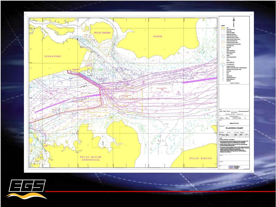
12 Strait Line Diagram Route Position List

13

14 Pre Survey Desktop Study Output from planning activities will be input to a pre survey DTS Risk and hazards for each route section will be assessed and summarized in a Risk Matrix In addition to archival research, the desk study will document information gathered from visits to the system landing sites The DTS will recommend appropriate route survey procedures designed to prove viability of the pre survey planning effort

15 Table XX: Risk Summary along the ANY 1 Cable Route RISK CATEGORY REGION Outcrops Cemented Sediment Slope Instability Seismicity/ Faulting Volcanic Activity Tsunamis Steep Slopes Bottom Currents Fishing Activities Resources Exploration Shipping Activity/ Anchoring Cable Congestion Military Activities/ UXO Wrecks/ Debris Landing site Inner Shelf (0 70mwd) H L L L L L L H M M M H M M Landing site Outer Shelf (70 150mwd) L H L L L L L M M M M M M M Continental Slope M L M L L L M M M L L L M M XXX Basin L L L L L L L M L L L L L L XXX Ridge L L L L L L M L L L L L L L XXX Basin L L L L L L L L L L L L L L XXX Basin L L L L L L L L L L L L L L XXX Rise L M L L L L M L L L L L L L XXX Basin L L L L L L L L L L L L L L Landing 2 approach H M M L M M M L L L L L M M XXX Sea L L L L L L M L L L L L L L Landing 3 approach H M L M L L L L L L L L L L XXX Sea M M M M M M H L L M L L L L South XXX Trench M M M M M L M M L L L L L L XXX Trench M M H H L L M M L L L L L L XXX Islands M L L L M L L L L L L L L L XXX Strait M L M M M L M M L L L L L L Landing 4 approach M L M M M M M M L L M L L L XXX Sea M L L H H M L L L L L L L L XXX Plateau L L L L L L L L L L L L L L East XXX Seamounts L L L L L L L L L L L L L L East XXX Basin M L L M M L L L L L L L L L XXX Trench H L M M M L H L L L L L L L Landing 5 approach H L H M M M H L L L L M M M LEVELS OF RELATIVE CONCERNS High (H) Medium (M) Available data indicate a significant risk and continuing concern from this source Available data indicate a possible risk that needs to be better assessed Low (L) Available data indicate that while present continuously or intermittently in some areas, this concern is unlikely to affect cable integrity

16 The Route Survey Provides information required to confirm or amend the preliminary pre survey DTS route Defines and documents the final route Enables final cable engineering to be defined Provides the system installer with the data required to finalize installation procedures Identifies potential post installation/residual hazards including unmitigated risks from potential tectonic activity during the system design life

17 Route Survey Offshore Vessel

18 Route Survey Data Sets Data is collected along a narrow strip of seabed, typically 500m to 3 x water depth wide and includes: Bathymetric data seabed topography Sonar imagery data seabed surface features Sub bottom profiling data shallow sub surface soil profile Burial assessment data mechanical properties of the seabed soils within the planned burial profile (typically 1m to 3m) Geophysical and soils data usually only collected where cable protection by burial is planned typically up to a maximum water depth of 1,000m; rarely up to 2,000m Only bathymetric data collected in deep water

19 Multibeam Bathymetry Bathymetry and colocated back scatter data Digital data output can be rapidly processed and analysed Data used to develop seabed terrain model Resolution of multibeam systems is altitude dependant

20 High Resolution in Shallow Water

21 High Resolution in Shallow Water
22 Deep water data Philippine Trench maximum depth 10,400m
23 Side Scan Sonar Imagery Towed systems Depth range up to 3000m Provide images of seabed surface features Surface back scatter intensity can be used as indicator of seabed hardness
24 Side Scan Sonar Imagery
25 Sub bottom Data
26 Burial Assessment Gravity coring Cone Penetrometer Tests measure Tip resistance Sleeve friction Resistivity Typically to 3m below seabed Used to predict and categorize cable plough burial performance
27 Short reporting leadtimes have led to: On-board data acquisition, processing & charting Telemetry of processed data to shore based offices Data output direct to route planning software (Makai) Final reporting typically office based
28
29
30
31 UNCLOS Provisions & Application Cable route surveys are part of the process of laying submarine cables 10 articles of UNCLOS govern the activities related to cables in the territorial sea, the EEZ, the continental shelf and the high seas The freedom to navigate and lay cables and the operations associated with ships exercising these freedoms are expressly provided for under these articles In reality, an increasing number of costal states are now insisting on permits; or the lesser, but no less program challenging, Letters of No Objection issued by the coastal state, for survey and cable installation within their EEZ The justification often given by coastal states imposing these permitting restrictions, is that the route survey constitutes Marine Scientific Research, the tools and methodology of which being similar
32 Cable Route Surveys Why this activity is not Marine Scientific Research The fundamental objective of the cable route survey is to: Prove and document the initial route developed during initial project planning stages Identify and where practical, develop the initial route to avoid obstructions and hazards found during the survey Determine final cable engineering and cable quantities Confirm or amend preliminary cable protection strategies Provide all data and documentation necessary to support cable installation Provide the database framework for system maintenance
33 Cable Route Surveys Why this activity is not Marine Scientific Research Marine Scientific Research is not defined in the Convention; however, it is clear that the scope of submarine cable route surveys cannot be construed as Scientific Research The route survey scope is not designed to perform systematic investigations into and study of the marine environment in order to establish facts and reach new conclusions about the marine environment, nor To carry out exploration or exploitation of living or non living resources Drill on the continental shelf Use explosives or harmful substances Construct, operate or use artificial islands, installations or structures
34 Permits Program Impacts & Consequences Requirement for survey vessel to mobilize in advance of all survey operational permits being issued has resulted in: Inability to commence operations upon arrival on site Dislocation of planned survey phase sequence Protracted vessel standby Long out of sequence and non productive vessel transits Increased costs through consequential Contract Variations Substantial overall project delays with loaded installation vessels idle waiting on survey data and installation permits Increasing requirement for marine operational permits in EEZs particularly for non landing countries in apparent contravention of UNCLOS provisions has further negatively impacted permit lead time and project progress
35 Permits Program Impacts & Consequences In the case of recent projects in the Red Sea, Gulf of Aden and Arabian Sea, permit delays caused survey work to be pushed into the Southwest Monsoon with the attendant weather delays and negative impact on survey data quality The one permit at a time policy of adopted by some countries has required out of sequence survey operations, long transits between permitted and non permitted routes further escalating cost
36 Survey Permits & Conditions Securing permissions to carry out survey operations vary from coastal state to coastal state and from straightforward to highly complex with lead times measured in days to many months; associated conditions can include: Requirement for all survey team members and vessel crew to undergo security checks The imposition of restrictions on certain nationalities within the survey team and/or vessel crew; and even the country where the survey contractor s company is registered Requirement for survey operations to be witnessed by security officers Mandate for survey work be conducted by national research institutes to pre agreed hand over locations Requirement for copies of survey data to be made available to the coastal state upon completion of the survey and/or copies of reports
37 Questions & Clarifications Questions and clarifications on the content of this presentation or related matters can be addressed to: Graham Evans E mail gevans@egssurvey.com
Cable System Planning and Permitting: Business and Stakeholder Considerations
 Cable System Planning and Permitting: Business and Stakeholder Considerations Submarine Cables in the Sargasso Sea: Legal and Environmental Issues in Areas Beyond National Jurisdiction The George Washington
Arctic Fibre Submarine Cable System
 Arctic Fibre Submarine Cable System Desktop Study & Cable Engineering 10 February 2012 Desktop Study: Phase 1 Scope Philosophy March 7, 2012 DTS Phase 1 Scope of Work Goal: Identify feasible marine survey
An Overview of Seabed Surveys (High resolution Geophysical Site Surveys)
") An Overview of Seabed Surveys (High resolution Geophysical Site Surveys) Anna Fulop Chief Geoscientist Fugro Survey Limited 22 April 2015 Agenda Introduction Site survey - purpose and requirements Principles,
An Overview of Seabed Surveys (High resolution Geophysical Site Surveys) Anna Fulop Chief Geoscientist Fugro Survey Limited 22 April 2015 Agenda Introduction Site survey - purpose and requirements Principles,
Chapter Overview. Bathymetry. Measuring Bathymetry. Echo Sounding Record. Measuring Bathymetry. CHAPTER 3 Marine Provinces
 Chapter Overview CHAPTER 3 Marine Provinces The study of bathymetry charts ocean depths and ocean floor topography. Echo sounding and satellites are efficient bathymetric tools. Most ocean floor features
Why Submarine Cables?
 Nalaka Siriwardena Engineer/SEA-ME-WE 4 Project Engineer/Projects Why Submarine Cables? Cost effective on large routes High bandwidth due to the evolution of technology such as DWDM High Quality with low
Robert Beckman Director, Centre for International Law National University of Singapore
 CIL ICPC WORKSHOP ON THE PROTECTION OF SUBMARINE CABLES Singapore, 14-15 April 2011 Session 2 : Repairing Submarine Cables Best National Practices for the Repair of Submarine Cables Robert Beckman Director,
Permanent Reservoir Monitoring (PRM) System Installation: The Installers Perspective
 System Installation: The Installers Perspective") Permanent Reservoir Monitoring (PRM) System Installation: The Installers Perspective Introduction Global Marine Systems Limited (Global Marine) has a vast wealth of knowledge in designing planning and
Permanent Reservoir Monitoring (PRM) System Installation: The Installers Perspective Introduction Global Marine Systems Limited (Global Marine) has a vast wealth of knowledge in designing planning and
GEO-MARINE TECHNOLOGY, INC. A Geological, Geophysical, and Hydrographic Survey Consultancy
 COMPANY PROFILE OUR MISSION AND TRADE OUR MISSION: OUR TRADE: We are high-quality data analysts who combine scientific expertise with state-of-the-art software to efficiently provide solid technical products
HYDROGRAPHIC INFORMATION AND THE SUBMARINE CABLE INDUSTRY
 HYDROGRAPHIC INFORMATION AND THE SUBMARINE CABLE INDUSTRY P G Allan (SEtech Ltd) 1 Presented at Hydro 2001 at Norwich, March 2001 1. INTRODUCTION Accurate mapping of the seabed is an essential requirement
Proven expertise and total reliability to support globally recognised oil and gas clients
 Oil & Gas Services B ibby HydroMap works closely with clients from the oil and gas industry to provide a variety of services relevant to all construction and monitoring phases. Our flexiblity and range
The Territorial Waters, Continental Shelf, Exclusive Economic Zone and other Maritime Zones Act, 1976, Act No. 80 of 28 May 1976
 Page 1 The Territorial Waters, Continental Shelf, Exclusive Economic Zone and other Maritime Zones Act, 1976, Act No. 80 of 28 May 1976 Short title and commencement 1. (1) This Act may be called the Territorial
NEW DIGITAL TERRAIN MODELING (DTM) TOOLS FOR CABLE ROUTE PLANNING by Dr. Jose M. Andres Makai Ocean Engineering Inc.
 TOOLS FOR CABLE ROUTE PLANNING by Dr. Jose M. Andres Makai Ocean Engineering Inc.") NEW DIGITAL TERRAIN MODELING (DTM) TOOLS FOR CABLE ROUTE PLANNING by Dr. Jose M. Andres Makai Ocean Engineering Inc. EXISTING CABLE ROUTE PLANNING TOOLS In recent years, methods used for submarine cable
NEW DIGITAL TERRAIN MODELING (DTM) TOOLS FOR CABLE ROUTE PLANNING by Dr. Jose M. Andres Makai Ocean Engineering Inc. EXISTING CABLE ROUTE PLANNING TOOLS In recent years, methods used for submarine cable
HV Submarine Cable Systems Design, Testing and Installation
 HV Submarine Cable Systems Design, Testing and Installation CIGRE Ireland Technical Seminar 6 th October 2010 Robert Donaghy Senior Consultant Engineer, ESB International Presentation Overview Applications
Law of Ukraine on the exclusive (marine) economic zone of 16 May 1995
 economic zone of 16 May 1995") Page 1 Law of Ukraine on the exclusive (marine) economic zone of 16 May 1995 Taking into consideration the relevant provisions of the 1982 United Nations Convention on the Law of the Sea, Ukraine hereby
Page 1 Law of Ukraine on the exclusive (marine) economic zone of 16 May 1995 Taking into consideration the relevant provisions of the 1982 United Nations Convention on the Law of the Sea, Ukraine hereby
Ocean Engineering, Surveying and Mapping Services
 Ocean Engineering, Surveying and Mapping Services FUGRO PELAGOS, INC. Fugro collects and interprets data related to the earth s surface and the soils and rocks beneath. It provides advice based on the
MARINE SCIENTIFIC RESEARCH : A SOUTH AFRICAN EXPERIENCE OF UNCLOS PART XIII. Abstract
 Fourth Biennial ABLOS Scientific Conference : Marine Scientific Research and the Law of the Sea : The Balance between Coastal States and the International Rights MARINE SCIENTIFIC RESEARCH : A SOUTH AFRICAN
How Did These Ocean Features and Continental Margins Form?
 298 10.14 INVESTIGATION How Did These Ocean Features and Continental Margins Form? The terrain below contains various features on the seafloor, as well as parts of three continents. Some general observations
Submarine Cables: Critical Infrastructure Supplier Perspective
 Submarine Cables: Critical Infrastructure Supplier Perspective Dr. Ronald J. Rapp Director, Cable Engineering & Technology Tyco Electronics Subsea Communications LLC (TE SubCom) The 34 th Annual COLP Conference
Pipelines and seabed intervention
 Workshop on seabed habitats of environmental concern Jørn Spiten Content Pipeline - route design Seabed Intervention - Trenching - Ploughing - Dredging - Rock installation 2 Pipeline routes 3 Pipeline
MINISTÈRE DE L INDUSTRIE Entreprise Tunisienne D activités Pétrolières. Offshore oil and gas exploration and production legal framework in Tunisia
 Offshore oil and gas exploration and production legal framework in Tunisia Author: Mr Hédi HERICHI Lawyer and Central Director March 2014 Table of content Introduction : 1- Definition of some useful notions
CHALLENGES OF THE NORD STREAM STREAMLINING THE INTERNATIONAL LEGAL FRAMEWORK FOR SUBMARINE PIPELINES
 CHALLENGES OF THE NORD STREAM STREAMLINING THE INTERNATIONAL LEGAL FRAMEWORK FOR SUBMARINE PIPELINES Dr. Sergei Vinogradov CEPMLP, Dundee European Gas Grids Nord Stream truly international project Crosses
COMPANY PROFILE PELICAN COMPANY LIMITED
 COMPANY PROFILE PELICAN COMPANY LIMITED, Vung Tau 2013 Page 2 1. About Us Based in the city of, and established in 2010 by the professionals in their field of expertise, Pelican Company Limited provides
Maritime Security and Safety. Presentation Overview
 Maritime Security and Safety UNITAR/DOALOS Briefing 17 October 2007 Michele Ameri and Michael Shewchuk Presentation Overview United Nations Open-ended ended Informal Consultative Process on Oceans and
Impact & Consequences to Submarine Cable Systems Submarine Networks World - 10 September 2013
 Maritime Jurisdictional Creep Impact & Consequences to Submarine Cable Systems Submarine Networks World - 10 September 2013 Kent Bressie Kent is a partner with the law firm of Wiltshire & Grannis LLP in
./01&2/M./T34 1MP36T ST3T.M./T. 1a$t3l$4 536e-al4 13$7363 83%3te9. Sol9ara 1 Pro;ect. !"l$%e ( Mai$ &e(ort. Te-t. )e*te%,e- 2//0 :; <//0=>=?
e*te%,e- 2//0 :; <//0=>=?") ./01&2/M./T34 1MP36T ST3T.M./T 1a$t3l$4 536e-al4 13$7363 83%3te9 Sol9ara 1 Pro;ect!"l$%e ( Mai$ &e(ort Te-t )e*te%,e- 2//0 :; =?@ ENVIRONMENTAL IMPACT STATEMENT VOLUME A: MAIN REPORT TEXT CR 7008_09_v4
./01&2/M./T34 1MP36T ST3T.M./T 1a$t3l$4 536e-al4 13$7363 83%3te9 Sol9ara 1 Pro;ect!"l$%e ( Mai$ &e(ort Te-t )e*te%,e- 2//0 :; =?@ ENVIRONMENTAL IMPACT STATEMENT VOLUME A: MAIN REPORT TEXT CR 7008_09_v4
Invitation for Tender: Sea Bed Survey Services (Geophysical, Bathymetric and Geotechnical)
") Invitation for Tender: Sea Bed Survey Services (Geophysical, Bathymetric and Geotechnical) 1. Introduction Moni Pulo Limited (Petroleum Development) invites interested and reputable contractors with relevant
Invitation for Tender: Sea Bed Survey Services (Geophysical, Bathymetric and Geotechnical) 1. Introduction Moni Pulo Limited (Petroleum Development) invites interested and reputable contractors with relevant
THE ROLE OF BATHYMETRY IN INTERNATIONAL MARITIME LAW AND IN THE PROVISIONS OF THE UN CONVENTION ON THE LAW OF THE SEA By NEIL GUY.
 Charting the Secret World of the Ocean Floor. The GEBCO Project 1903-2003 1 THE ROLE OF BATHYMETRY IN INTERNATIONAL MARITIME LAW AND IN THE PROVISIONS OF THE UN CONVENTION ON THE LAW OF THE SEA By NEIL
UN Law of the Sea Convention Main concepts and principles of environmental protection
 UN Law of the Sea Convention Main concepts and principles of environmental protection Hans Chr. Bugge The question: How to regulate and control activities outside territorial waters, on the high seas?
CSCAP MEMORANDUM NO. 24 Safety and Security of Vital Undersea Communications Infrastructure
 CSCAP MEMORANDUM NO. 24 Safety and Security of Vital Undersea Communications Infrastructure A Memorandum from the Council for Security Cooperation in the Asia Pacific (CSCAP) May 2014 Council for Security
MARINE GEOPHYSICS. Oil & Gas PROJECT SUMMARY SHEET. Project Title: BP WEST JAVA, ONWJ, PIPELINE INSPECTION BY VESSEL BASED SURVEY.
 MARINE GEOPHYSICS BP WEST JAVA, ONWJ, PIPELINE INSPECTION BY VESSEL BASED SURVEY BP Offshore North West Java Indonesia Description: PT EGS Indonesia was awarded a contract for a high order acoustic (multibeam
Japan s Arctic Policies with regards to Maritime Law and Jurisdictional Issues
 1 Japan s Arctic Policies with regards to Maritime Law and Jurisdictional Issues Prof T Ikeshima LLB, LLM, DES, PhD Waseda University 2 Outline Introduction: geographical background Japan s interests and
Swedish Law as an Example The Nairobi Convention Summary. Wreck Removal. Jhonnie Kern University of Gothenburg
 Wreck Removal Jhonnie Kern University of Gothenburg 13 October 2015 WRECK REMOVAL Swedish Law as an Example The Nairobi Convention Purposes of the Convention Scope of the Convention Definitions of Ship
Contents. 1. PROFILE p2. 2. SERVICES 2.1 Offshore Support Services p 4 Offshore support p 6 ROV operations p 8
 OCTOBER 2013 22 Contents 1. PROFILE p2 2. SERVICES 2.1 Offshore Support Services p 4 Offshore support p 6 ROV operations p 8 2.2 Hydrographic & Geophysical services p 10 Bathymetric surveys p 12 High resolution
and to mutually agree mitigation measures to reduce identified concerns and risks to acceptable levels.
 PTC ID: 88 Connecting Offshore Platforms to a Subsea Cable System Jerry Brown, Ocean Specialists Inc. Technical Manager Subsea. Introduction Bandwidth hungry applications for process controls and business
Figure 1. Submarine cable plough
 Paramètres de calcul géotechnique. Magnan (ed.) 2002, Presses de l ENPC/LCPC, Paris PARAMETER SELECTION FOR SUBMARINE CABLE BURIAL ASSESSMENT CHOIX DES PARAMÈTRES POUR l ENFOUISSEMENT DES CÂBLES SOUS-MARINS
The Integration of Hydrographic and Oceanographic Data in a Marine Geographic Information System U.S. Hydro 2015
 The Integration of Hydrographic and Oceanographic Data in a Marine Geographic Information System U.S. Hydro 2015 Karen Hart CARIS USA Oceanography and Hydrography Defined Oceanography: The branch of Earth
The Importance of the United Nations Law of the Sea Convention to the Cable Industry By Douglas R. Burnett 1
 The Importance of the United Nations Law of the Sea Convention to the Cable Industry By Douglas R. Burnett 1 Ladies and Gentlemen, thank you for the opportunity to tell you about why UNCLOS is important
Overview of geophysical and geotechnical marine surveys for offshore wind transmission cables in the UK. September 2015
 Overview of geophysical and geotechnical marine surveys for offshore wind transmission cables in the UK September 2015 Disclaimer Whilst the information contained in this report has been prepared and collated
OCEANOGRAPHY Vol.II Morphology of Ocean Floor and Plate Tectonics - Chengsung Wang MORPHOLOGY OF OCEAN FLOOR AND PLATE TECTONICS
 MORPHOLOGY OF OCEAN FLOOR AND PLATE TECTONICS Chengsung Wang National Taiwan Ocean University, Keelung 202, Taiwan, China Keywords: Morphology of sea floor, continental margins, mid-ocean ridges, deep-sea
The Arctic-2010 cruise: bathymetric survey for delineation of the extended continental shelf of the Russian Federation in the Arctic
 The Arctic-2010 cruise: bathymetric survey for delineation of the extended continental shelf of the Russian Federation in the Arctic Sergey Alekseev 1, Ivan Glumov 2, Andrey Morozov 3, Konstantin Stavrov
Issue Brief. The United States is already a party to 20. Ratifying UN Law of the Sea Treaty Would Harm U.S. Sovereignty Part I
 September 21, 2011 Published by The Center for Sovereignty and Security A Division of Freedom Alliance Ratifying UN Law of the Sea Treaty Would Harm U.S. Sovereignty Part I by Thomas W. Jacobson, M.A.
Hvor svært kan det være udnyt din viden med omhu!
 Hvor svært kan det være udnyt din viden med omhu! First Sub sea cable installed 1866 over the Atlantic Why make it so difficult, when it has been done for more than 145 years? Equipment and the technology
Hydrography at IHO cat A level: Scientific Education, at Sea Training, and Interaction with the Industry. N. Debese, R. Moitié, N.
 Hydrography at IHO cat A level: Scientific Education, at Sea Training, and Interaction with the Industry N. Debese, R. Moitié, N. Seube analysis CHC 2010-2 Located in Brest: takes benefits of the French
How Efficient Is Your Hybrid?
 How Efficient Is Your Hybrid? Legal and Regulatory Consequences of Deploying Undersea Telecommunications Cables with Additional Energy- or Scientific Research-Related Functions Kent Bressie 13 April 2011
London Array. Operations and Maintenance
 London Array londonarray.com London Array Operations & Maintenance Base Port of Ramsgate Military Road Ramsgate CT11 9LG Registered in England and Wales No 04344423 Operations and Maintenance 1 2 Operations
TECTONICS ASSESSMENT
 Tectonics Assessment / 1 TECTONICS ASSESSMENT 1. Movement along plate boundaries produces A. tides. B. fronts. C. hurricanes. D. earthquakes. 2. Which of the following is TRUE about the movement of continents?
COOK STRAIT SUBMARINE CABLE PROTECTION ZONE
 COOK STRAIT SUBMARINE CABLE PROTECTION ZONE An information brochure on the Submarine Cable Protection Zone across Cook Strait and how it affects mariners, fishers, divers and the public. February 2011
Ocean Dumping Act: A Summary of the Law
 Claudia Copeland Specialist in Resources and Environmental Policy December 15, 2010 Congressional Research Service CRS Report for Congress Prepared for Members and Committees of Congress 7-5700 www.crs.gov
Horizon Survey and Geotechnical Companies
 Oil & Gas Directory Middle East - 2013 147 Horizon Survey and Geotechnical Companies Corporate P r ofile OUR PEDIGREE Horizon provides comprehensive survey and geotechnical services to the offshore industry
The concepts developed in this standard include the following: Oceans cover about 70% of the surface of the Earth.
 Name Date Grade 5 SOL 5.6 Review Oceans Made by SOLpass - www.solpass.org solpass100@comcast.net Reproduction is permitted for SOLpass subscribers only. The concepts developed in this standard include
Pollution Response RESPONDING TO AN OIL SPILL
 Pollution Response RESPONDING TO AN OIL SPILL Most oil spills within New Zealand waters are likely to happen close to the coast or in harbours. This makes it extremely difficult for responders to prevent
AGM presentation 13 May 2009
 AGM presentation 13 May 2009 1 Preparation for drilling Select best prospects for drilling Conduct site surveys Submit environmental impact assessment (EIA) Gain drilling consents Plan logistics Select
Plate Tectonics: Ridges, Transform Faults and Subduction Zones
 Plate Tectonics: Ridges, Transform Faults and Subduction Zones Goals of this exercise: 1. review the major physiographic features of the ocean basins 2. investigate the creation of oceanic crust at mid-ocean
WORKSHOP REPORT CENTRE FOR INTERNATIONAL LAW CIL. WORKSHOP ON SUBMARINE CABLES AND LAW OF THE SEA 14 15 December 2009, Singapore
 CENTRE FOR INTERNATIONAL LAW CIL WORKSHOP REPORT by Robert Beckman Tara Davenport WORKSHOP ON SUBMARINE CABLES AND LAW OF THE SEA 14 15 December 2009, Singapore Co-sponsored by WORKSHOP ON SUBMARINE CABLES
Shallow Water Swath Bathymetry from Small Platforms. Advances in Seafloor Mapping Sonar, 30 Dec 2009 Systems Engineering & Assessment Ltd.
 Shallow Water Swath Bathymetry from Small Platforms Advances in Seafloor Mapping Sonar, 30 Dec 2009 Systems Engineering & Assessment Ltd. Presentation Requirements, applications and challenges SWATHplus
Convention on the High Seas 1958
 Convention on the High Seas 1958 Done at Geneva on 29 April 1958. Entered into force on 30 September 1962. United Nations, Treaty Series, vol. 450, p. 11, p. 82. Copyright United Nations 2005 Convention
THE JONES ACT ONE MORE VARIABLE IN THE OFFSHORE WIND EQUATION
 THE JONES ACT ONE MORE VARIABLE IN THE OFFSHORE WIND EQUATION By Douglas Burnett and Michael Hartman 1 Of the many pieces to the offshore wind puzzle for the United States, the Jones Act and other statutory
28 September 2012 BY ELECTRONIC FILING
 1200 18TH STREET, N.W., STE. 1200 WASHINGTON, D.C. 20036-2516 U.S.A. TEL +1 202 730 1300 FAX +1 202 730 1301 WWW.WILTSHIREGRANNIS.COM ATTORNEYS AT LAW BY ELECTRONIC FILING Ms. Jennifer Golladay Bureau
Developing Ocean Energy in Ireland. Belmullet Wave Energy Test Site
 Developing Ocean Energy in Ireland Belmullet Wave Energy Test Site Where does our energy come from? Most of the energy we use in Ireland comes from fossil fuels such as oil, coal, peat and gas. We burn
International connectivity submarine cables. Simon Smith Director Regulatory Affairs
 International connectivity submarine cables Simon Smith Director Regulatory Affairs 1 Company Overview Ownership of Asia-Pacific s most extensive privately-owned high-capacity submarine cable system(s)
The Application of Law on Pollution Control towards Marine Biodiversity Conservation in Malaysia
 2011 International Conference on Environment and BioScience IPCBEE vol.21 (2011) (2011) IACSIT Press, Singapore The Application of Law on Pollution Control towards Marine Biodiversity Conservation in Malaysia
What is geotechnical risk?
 1 MANAGING GEOTECHNICAL RISK Dr David Cathie, Cathie Associates What is geotechnical risk? The saying "ignorance is bliss" applies well to geotechnical problems. Out of sight, out of mind often applies
APPLICATION FOR THE CONSENT TO CONDUCT MARINE SCIENTIFIC RESEARCH IN AREAS UNDER NATIONAL JURISDICTION OF THE UNITED KINGDOM
 APPLICATION FOR THE CONSENT TO CONDUCT MARINE SCIENTIFIC RESEARCH IN AREAS UNDER NATIONAL JURISDICTION OF THE UNITED KINGDOM 1. General information Date: 15/10/2012 1.1 Cruise name and/or number: 1.2 Sponsoring
CONCEPT FOR ACTIVITY 1: DYNAMIC & PROACTIVE ROUTES OR GREEN-ROUTES
 TEN-T PROJECT NO: 2010-EU-21109-S CONCEPT FOR ACTIVITY 1: DYNAMIC & PROACTIVE ROUTES OR GREEN-ROUTES January 2012 TABLE OF CONTENTS 1 INTRODUCTION... 3 1.1 Scope and purpose... 3 1.2 Objectives and expected
Cable Laying and Repair - Cable Ship Operations
 http://oceanexplorer.noaa.gov/explorations/03edge/background/sargassum/sargassum.html Cable Laying and Repair - Cable Ship Operations Dr. R.J. Rapp, Director, Industry & Marine Liaison, TE SubCom Submarine
Search for Containers of Radioactive Waste on the Sea Floor Herman A. Karl
 Search for Containers of Radioactive Waste on the Sea Floor Herman A. Karl Summary and Introduction Between 1946 and 1970, approximately 47,800 large containers of low-level radioactive waste were dumped
The use of Satellite Remote Sensing for Offshore Environmental Benchmarking
 The use of Satellite Remote Sensing for Offshore Environmental Benchmarking Michael King Fugro NPA Limited Fugro NPA (Formerly Nigel Press Associates) World leading Satellite Remote Sensing & Geoscience
Professional Resumé of Geoffrey Hokin
 Professional Resumé of Geoffrey Hokin Personal Details Name: Location: Occupation: Geoffrey Hokin MSc (Hons.) Geology Toowoomba, QLD Geologist, Exploration Manager Career Summary In my Geology career I
Applications of Integrated Vessel-based LiDAR, Multibeam Bathymetry, and Geophysical Surveys for Geohazard Assessments and Site Characterization
 Applications of Integrated Vessel-based LiDAR, Multibeam Bathymetry, and Geophysical Surveys for Geohazard Assessments and Site Characterization James Fisher Engineering Geologist Todd Mitchell Survey
1.0 INTRODUCTION 2.0 SCOPE OF WORK. DATE July 29, 2010 PROJECT No. 09-1436-5008/2000
 DATE July 29, 2010 PROJECT No. 09-1436-5008/2000 TO Geoff Sinnett Ministry of Agriculture and Lands, Crown Land Restoration Branch cc Dawn Flotten FROM Karl Manzer EMAIL kmanzer@golder.com LADYSMITH HARBOUR
POSITION DESCRIPTION 1 PURPOSE OF POSITION
 POSITION DESCRIPTION Position Title: Senior Hydrographic Surveyor Division: Operations Section: Survey Position Title of Supervisor: Executive Manager Operations 1 PURPOSE OF POSITION Responsible for the
Resolving the South China Sea dispute
 Disarmament and International Security Committee Resolving the South China Sea dispute Introduction Territorial disputes in South China Sea have dominated the region for centuries, but it has not been
Removal of Wrecks Directive 2015
 Removal of Wrecks Directive 2015 Directive 01-2015 The Director of the Department of Marine Services and Merchant Shipping (ADOMS), in exercise of the powers conferred by Section 7, sub-section (3) of
WORLD REGIONAL GEOGRAPHY. By Brett Lucas
 WORLD REGIONAL GEOGRAPHY By Brett Lucas PACIFIC REALM AND POLAR Defining the Realm & Regions Defining the Realm Sea Hemisphere: seas cover nearly an entire hemisphere: Fragmented, culturally complex
Proposal for a RECOMMENDATION OF THE EUROPEAN COMMISSION
 EUROPEAN COMMISSION Brussels, XXX [ ] (2013) XXX draft Proposal for a RECOMMENDATION OF THE EUROPEAN COMMISSION Providing minimum principles for the exploration and production of hydrocarbons (especially
Harmonizing Survey Deliverables Emerging Standards and Smart Data Exchange
 Harmonizing Survey Deliverables Emerging Standards and Smart Data Exchange Andy Hoggarth and Karen Cove, CARIS, Fredericton, Canada Introduction When a survey company plans a project the deliverables are
Australia's approach to emergency response and towage
 9 th Asia Pacific Heads of Maritime Safety Authorities Forum Vina Del Mar, Chile, 18-21 April 2006 Australia's approach to emergency response and towage Clive Davidson Chief Executive Australian Maritime
Submarine Cables and Pipelines Protection Order 1992
 Reprint as at (SR 1992/246) : revoked, on 9 April 2009, by clause 5 of the Protection Order 2009 (SR 2009/41). PURSUANT to the Protection Act 1966, Her Excellency the Governor General, acting by and with
Limits in the Seas. United States Department of State. Bureau of Oceans and International Environmental and Scientific Affairs
 United States Department of State Bureau of Oceans and International Environmental and Scientific Affairs Limits in the Seas No. 135 Grenada: Archipelagic and other Maritime Claims and Boundaries LIMITS
Submission by the Republic of Seychelles to the Commission on the Limits of the Continental Shelf concerning the Northern Plateau Region
 Submission by the Republic of Seychelles to the Commission on the Limits of the Continental Shelf concerning the Northern Plateau Region EXECUTIVE SUMMARY May 2009 1982 UNITED NATIONS CONVENTION ON THE
New Coastal and Inland Water Mapping System Promises Significant Increases in Productivity with Virtual Real Time Map Production
 New Generation Mapper for Shallow Water Hydrography By: Pete Alleman, Thomas Chance, and Art Kleiner (printed in Sea Technology Magazine June, 1993) New Coastal and Inland Water Mapping System Promises
Operations in the Arctic areas? New challenges: Exploration Development Production
 Operations in the Arctic areas? New challenges: Exploration Development Production The oil and gas cycle Life cycle of oil and gas (time) 1) 2) 3) 4) 5) 6) Activity In-house study and get licenses: Find
Earth Science Chapter 14 Section 2 Review
 Name: Class: Date: Earth Science Chapter 14 Section Review Multiple Choice Identify the choice that best completes the statement or answers the question. 1. Which of the following is NOT one of the three
INTERIM MEASURES ADOPTED BY PARTICIPANTS IN NEGOTIATIONS TO ESTABLISH SOUTH PACIFIC REGIONAL FISHERIES MANAGEMENT ORGANISATION
 INTERIM MEASURES ADOPTED BY PARTICIPANTS IN NEGOTIATIONS TO ESTABLISH SOUTH PACIFIC REGIONAL FISHERIES MANAGEMENT ORGANISATION Participants in the negotiations to establish a South Pacific Regional Fisheries
Turnkey Submarine Cable Systems
 Turnkey Submarine Cable Systems Submarine Telecommunications Systems at NSW Today NSW is one of the world s leading suppliers of fiber-optic submarine cable systems, energy cables, custom-made underwater
Baltic Sea Perspective on - Building a Gas Pipeline and - Oil Spills
 Baltic Sea Perspective on - Building a Gas Pipeline and - Oil Spills Dr Juha-Markku Leppänen Head of the Monitoring and Assessment Unit, Marine Research Centre, Finnish Environment Institute (SYKE) Content
Harmonizing Survey Deliverables Emerging Standards and Smart Data Exchange
 Harmonizing Survey Deliverables Emerging Standards and Smart Data Exchange Andy Hoggarth, CARIS 115 Waggoners Lane, Fredericton, New Brunswick, Canada andy.hoggarth@caris.com Karen Cove, CARIS 115 Waggoners
NSW Submarine Telecom Systems. Turnkey solutions for the future, delivered today.
 Submarine Telecom Systems. Turnkey solutions for the future, delivered today. Norddeutsche Seekabelwerke GmbH () The submarine competence center within the General Cable Group After was founded in 1899
DYNAMIC CRUST: Unit 4 Exam Plate Tectonics and Earthquakes
 DYNAMIC CRUST: Unit 4 Exam Plate Tectonics and Earthquakes NAME: BLOCK: DATE: 1. Base your answer to the following question on The block diagram below shows the boundary between two tectonic plates. Which
Delimitation of the Maritime Boundaries between the adjacent States. Nugzar Dundua United Nations The Nippon Foundation 2006-2007
 Delimitation of the Maritime Boundaries between the adjacent States Nugzar Dundua United Nations The Nippon Foundation 2006-2007 2007 What does delimitation means The low of the sea, in its essence, divides
ARMED PERSONNEL ONBOARD VESSELS IMO PERSPECTIVE. Chris Trelawny Senior Deputy Director Maritime Safety Division International Maritime Organization
 ARMED PERSONNEL ONBOARD VESSELS IMO PERSPECTIVE Chris Trelawny Senior Deputy Director Maritime Safety Division International Maritime Organization What is IMO? IMO: SAFE, SECURE AND EFFICIENT SHIPPING
Satellite Derived Bathymetry
 11 th CSPWG MEETING 28 April, 2015 CSPCWG10-08.7A Submitted by: Executive Summary: Related Documents: Related Projects: Paper for Consideration by CSPCWG Satellite Derived Bathymetry UK CSPCWG is invited
Module No. # 02. Impact of oil and gas industry on marine environment
 Health, Safety and Environmental Management in Petroleum and offshore Engineering Dr. Srinivasan Chandrasekaran Department of Ocean Engineering Indian Institute of Technology, Madras Module No. # 02 Lecture
hs2 Ground A non-technical guide
 hs2 Ground Investigations A non-technical guide Contents HS2 ground investigations 1 Essential Q&A 2 2 In-ground investigation techniques 9 2.1 Cable percussion borehole 10 2.2 Rotary core borehole 12
The optimum offshore survey workflow for high-quality GIS results. by integrating CARIS & EIVA software
 The optimum offshore survey workflow for high-quality GIS results by integrating CARIS & EIVA software As a result of a unique and dedicated partnership, CARIS and EIVA offer the optimum solution for offshore
Statistical Summary Marine Occurrences 2013
 Statistical Summary Marine Occurrences 2013 Foreword This document provides Canadians with an annual summary of selected maritime safety data. It covers commercial vessels, which include all vessels registered
Google Explores the 10 th Planet
 Google Explores the 10 th Planet Mermaids and Sea Serpents NASA has spent tens of billions of dollars exploring Planet Earth and the other 8 planets of our solar system yet there is one last great frontier
CROWN LAW STATUTORY OFFENCES REQUIRING THE CONSENT OF THE ATTORNEY-GENERAL
 CROWN LAW STATUTORY OFFENCES REQUIRING THE CONSENT OF THE ATTORNEY-GENERAL As at 1 July 2013 Antarctica Act 1960 s 3 Offences in Ross Dependency or any part of Antarctica other than the Ross Dependency
ANNEX 8B SCHEDULE OF UNITED STATES. Obligations Concerned: Most-Favored-Nation Treatment (Articles 8.4 and 15.4) Cross-Border Services and Investment
 Cross-Border Services and Investment") ANNEX 8B SCHEDULE OF UNITED STATES Sector: Communications Obligations Concerned: Most-Favored-Nation Treatment (Articles 8.4 and 15.4) Cross-Border Services and Investment measure that accords differential
ANNEX 8B SCHEDULE OF UNITED STATES Sector: Communications Obligations Concerned: Most-Favored-Nation Treatment (Articles 8.4 and 15.4) Cross-Border Services and Investment measure that accords differential
Offshore Work Packages
 Rampion Offshore Wind Farm Offshore Work Packages Meet The Buyer Naren Mistry, Engineering Manager 26 th Feb 2014 Rampion Offshore Project Scope Design, manufacture, transportation and Installation: Up