Development of BeiDou Navigation Satellite System
|
|
|
- Buck Tyler
- 10 years ago
- Views:
Transcription
1 The 7th Meeting of International Committee on GNSS Development of BeiDou Navigation Satellite System China Satellite Navigation Office November 5, 2012 Beijing, China

2 Part Ⅰ Development Plan Part Ⅱ System Progress Part Ⅲ Contribution to GNSS

3 Part Ⅰ Development Plan Part Ⅱ System Progress Part Ⅲ Contribution to GNSS

4 1. Development Objective Stable, reliable and high quality service Serve the world, benefit the mankind Objective: Meet the requirements of national security and social economic development. Accelerate informationization drive as well as economy development mode transformation. Realize social and economic benefits. Make contribution to international GNSS community.

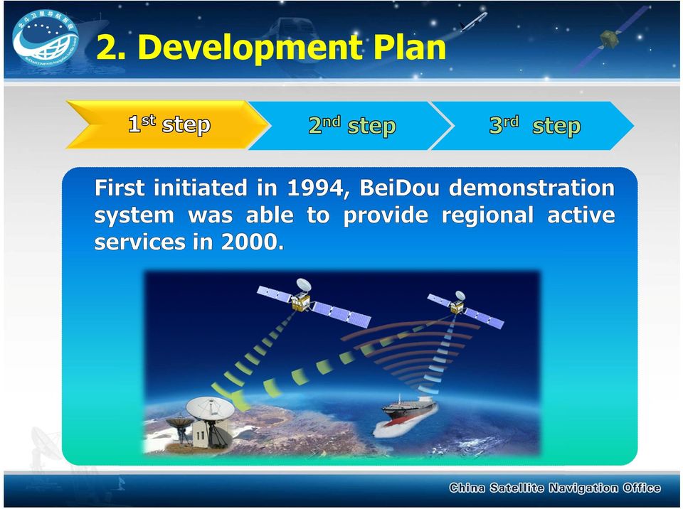
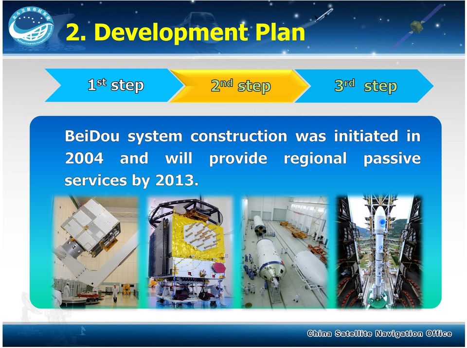
5 2. Development Plan 1 st Step 2 nd Step 3 rd Step BeiDou Demonstration System BeiDou Navigation Satellite System BeiDou Navigation Satellite System

6 2. Development Plan
7 2. Development Plan
8 2. Development Plan

9 3. Basic Policy Provide continuous space-based PVT services for global users free of charge, continue maintenance and complement in order to enhance service performance. Formulate application industry plan and standard to push forward development of GNSS industry and promote BeiDou worldwide use. Strengthen international cooperation, including advocating for international GNSS Monitoring and Assessment, achieving compatibility and interoperability between BeiDou and other GNSS, ensuring BeiDou diversified applications.

10 4. System Description System Structure 5 GEO Satellites 30 Non-GEO Satellites Master Control Station (MCS) Uplink Stations (US) Monitoring Stations (MS) BeiDou user terminals Terminals compatible with other GNSS
 BeiDou user terminals Terminals")
11 4. System Description Service and Performance

12 Part Ⅰ Development Plan Part Ⅱ System Progress Part Ⅲ Contribution to GNSS

13 1. System Construction 1) Satellite launch record IGSO GEO 2 MEO Since ICG-6 2 MEO GEO

14 1. System Construction 2) Constellation status 14 BeiDou operational satellites in orbit. Constellation of 5GEOs,5IGSOs and 4MEOs. Stage BeiDou Navigation Satellites System Num Type MEO GEO GEO GEO IGSO GEO IGSO IGSO IGSO IGSO GEO MEO MEO MEO MEO GEO Date Status Operational Flight test In maintenance

15 1. System Construction 3) Ground control segment Construction of Master Control Station, Uplink Stations and Monitoring Stations have been accomplished. Employ BeiDou Time (BDT) and CGCS2000 Coordinate. MCS US MS

16 1. System Construction 4) Coverage Service area: 55 o S ~55 o N, 55 o E ~180 o E. Service area PDOP HDOP VDOP

17 1. System Construction 5) Initial Operational Capability On December 27, 2011, started to provide IOC. ICD of BeiDou System (test version) and Development of BeiDou Navigation Satellite System (V2.0) was released.

18 1. System Construction 6) Practical Operational Capability Positioning and velocity accuracy Horizontal 10m(95%). Vertical 15m(95%). Velocity 0.2m/s. du/m du(95%) = 15.57m -20 2D(EN) du du(95%) = 14.73m du(95%) = 7.38m BJF1 station SPP(B1 with K8 for ionosphere delay correction) du(95%) = 5.78m 2D/m 5 0 PDOP -5 2D(95%) = 10.21m -10 PDOP D(95%) = 9.31m 2D(95%) = 4.92m 2 0 PDOP(95%) = 8.76 PDOP(95%) = 7.35 PDOP(95%) = 4.77 PDOP(95%) = G+4I 3G+5I(from 2012/02/07) 4G+5I(from 2012/04/16) 4G+5I+2M(from 2012/07/01) DOY(2012) 2D(95%) = 4.83m
 = 4.92m 2 0 PDOP(95%) = 8.76 PDOP(95%) = 7.35 PDOP(95%) = 4.77 PDOP(95%) = 4.")
19 1. System Construction 6) Practical Operational Capability Broadcast ephemeris precision URE 1.5m. Clock bias 5ns.

20 1. System Construction 6) Practical Operational Capability Orbit determination and time synchronization Orbit determination < 10 m. Time synchronization < 2ns.

21 1. System Construction 6) Practical Operational Capability Ionospheric Model Ionospheric correction of Klobuchar 8 model is about 80%.
22 1. System Construction 6) Practical Operational Capability Satellite clock performance frequency accuracy of the master clock is 1.62E-12. drift is 3.05E-14. ten thousand seconds stability is 6.59E-14. Pesgo1 Sub Title Pesgo1 Sub Title Pesgo1 Sub Title Value (sec) DS01 t: y: d: 2012/8/6 18:16: M 208.0M 208.2M 208.4M 208.6M 208.8M Time (sec) Residual of 2nd polynomial fitting (ns) Residual of linear fitting (ns) Subset 1 Subset 2 DS01 t: y: e-15 d: 2006/1/1 0:59:00 DS01 t: y: d: 2006/1/1 0:40: time (sec) Overlapping Allan Dev Tau (sec)
23 2. System Application Since IOC provision, the continuous constellation deployment, gradual improvement of service performance has promoted R&D of BeiDou chips and terminals. Implemented application demonstration in various industries and regions. Popularized mass market.
24 2. System Application 1) Fundamental Products Chips, antennas, OEM have been launched to market. Chips OEM Antenna
25 2. System Application 2) Industry Popularization Transportation Road transportation management. Marine Fishery Vessel position monitoring. Emergency rescue and region alarm. Port entry and depart management.
26 Rescue 2. System Application 2) Industry Popularization rescue dispatching. emergency communication. rapid report. Meteorology Meteorological sounding. Meteorological monitoring. Meteorological information gathering and release.
27 2. System Application 3) Popular Application BeiDou chips embedded mobile phones and vehicle terminals have been in practically used.
28 3. International Activity Undertake more international responsibilities through ICG related activities. Cooperate with major GNSS, and popularize applications with neighbor countries. Promote international technical exchange. Promote BeiDou to merge into international standards.
29 3. International Activity 1) Multilateral Coordination Deeply participate in activities of ICG as one of core system providers. Host the 7 th meeting of ICG. Speed up igmas construction, strengthen cooperation with IGS, related organizations and other GNSS. 8 th meeting of ICG Providers forum 55 th meeting of COPUOUS igmas tracking stations
30 3. International Activity 2) Bilateral Coordination Comply with radio regulations of ITU. carry out more than 10 rounds of bilateral and multilateral coordination to jointly share frequency and orbit resources orbit safety consultation meeting for140e Technical Working Group meeting on C&I between China and Europe 5 th Frequency coordination of China and US 12 th Satellite Network coordination meeting between China and Japan
31 3. International Activity 2) Bilateral Coordination Meetings between China and Russia Satellite Navigation Cooperation to promote satellite navigation monitoring, interoperability and application. Satellite navigation cooperation meetings between China and Pakistan to jointly promote BeiDou/GNSS international popularization. 2 nd China-Russia Aerospace cooperation working group meeting The 2 nd China-Pakistan Satellite Navigation Cooperation Meeting
32 3. International Activity 3) International Exchange Host world-oriented China Satellite Navigation Conference, more than 2000 persons presented in CSNC Take part in academic exchange activities sponsored by GNSS, international and regional organizations more than 10 times.
33 3. International Activity 3) International Exchange Education and training Set up international GNSS exchange and training center in Beihang University. Established GNSS frontier technology summer school. Established MASTA programme on GNSS International GNSS exchange and training center GNSS frontier technology summer school
34 3. International Activity 4) International Standardization Take part in 3 significant meetings of International Civil Aviation Organization (ICAO),promote BeiDou to enter into ICAO standard framework. Accomplish application procedure, promote BeiDou standardization in marine application. ICAO meeting Multi-GNSS marine application standardization meeting
35 Part Ⅰ Development Plan Part Ⅱ System Progress Part Ⅲ Contribution to GNSS
36 1. Unique Development Pattern Form the development philosophy of Region highlighted, Global service and Distinguished features. Explore the roadmap of gradual development. Adopt the integration method of passive position and short message communication.
37 2. Innovative Technology Design hybrid asymmetry constellation: consists of GEOs, IGSOs and MEOs, rapidly realize application step by step. Provide triple frequency signals. Optimize system mechanism by uniting RDSS, RNSS and Wide-area differential services.
38 3. Numerous Application Occasions Having service capability in Asia-Pacific region, provide numerous choices of multi-systems compatible application. Having service capability of triple frequency navigation signals, expand innovative chances of high-precision application. Having integrated service capability of RNSS and short message communication, support diversified application.
39 Conclusions BeiDou Construction The second deployment step has been accomplished. BeiDou will possess full operational capability early next year. BeiDou is expected to enter into comprehensive operational service stage. BeiDou Application BeiDou chips is matured day by day. Application is promoted in large scale. ICD (formal version) is to be released to support industry development.
40 Conclusions BeiDou International Activity Carry out international exchange, coordination and cooperation. Carry out BADEC, promote multi-gnss fusion applications. Speed up the construction of igmas, support international monitoring and assessment to ensure reliable GNSS services for global users.
41
PNT Evolution: Future Benefits and Policy Issues. Scott Pace Director, Space Policy Institute George Washington University Washington, D.C.
 PNT Evolution: Future Benefits and Policy Issues Scott Pace Director, Space Policy Institute George Washington University Washington, D.C. 5 November 2009 GPS is a Critical Component of the Global Information
Update of BeiDou International Education and Training Activities
 Update of BeiDou International Education and Training Activities Prof. Dr. WENG Jingnong Beihang University, P. R. China Beidou International Exchange and Training Center November, 2013 Outline Overview
A forum to discuss Global Navigation Satellite Systems (GNSS) to benefit people around the world
 to benefit people around the world") A forum to discuss Global Navigation Satellite Systems (GNSS) to benefit people around the world The International Committee on Global Navigation Satellite Systems (ICG) The United Nations General Assembly
A forum to discuss Global Navigation Satellite Systems (GNSS) to benefit people around the world The International Committee on Global Navigation Satellite Systems (ICG) The United Nations General Assembly
GENERAL INFORMATION ON GNSS AUGMENTATION SYSTEMS
 GENERAL INFORMATION ON GNSS AUGMENTATION SYSTEMS 1. INTRODUCTION Navigation technologies with precision approach and landing systems, for civilian and military purposes, enable aircrafts to perform their
GAGAN-FOP/PMR-05. Indian SBAS System - GAGAN
 GAGAN-FOP/PMR-05 Indian SBAS System - GAGAN GAGAN GPS Aided GEO Augmented Navigation (GAGAN) is India s regional Satellite Based Augmentation System (SBAS) India is working towards attaining APV 1 capability
Status, Development and Application
 Federal Space Agency GLONASS GLONASS Status, Development and Application Sergey G. Revnivykh International Committee on Global Navigation Satellite Systems (ICG) Second Meeting, September 4-7, 2007, Bangalore,
Proposal for the Regional Centre for Space Science & Technology Education in East Asia and the Pacific Under the UN Programme on Space Applications
 Proposal for the Regional Centre for Space Science & Technology Education in East Asia and the Pacific Under the UN Programme on Space Applications Dr. Weng Jingnong Director, Space Applications Education
Enabling RTK-like positioning offshore using the global VERIPOS GNSS network. Pieter Toor GNSS Technology Manager
 Enabling RTK-like positioning offshore using the global VERIPOS GNSS network Pieter Toor GNSS Technology Manager Introduction PPP/RTK Positioning Techniques PPP-AR Technology Presentation Overview PPP-AR
The European GNSS Programmes EGNOS and Galileo
 The European GNSS Programmes EGNOS and Galileo 6th ICG Conference Pieter De Smet European Commission 5 September 2011 1. State of Play of EGNOS 2. State of Play of Galileo 5 September, 2011 The European
The Evolution of the Global Navigation Satellite System (GNSS) Spectrum Use
 Spectrum Use") The Evolution of the Global Navigation Satellite System (GNSS) Spectrum Use Spectrum Management 2012 National Spectrum Management Association Scott Pace (with thanks to Chris Hegerty, MITRE) Space Policy
The Evolution of the Global Navigation Satellite System (GNSS) Spectrum Use Spectrum Management 2012 National Spectrum Management Association Scott Pace (with thanks to Chris Hegerty, MITRE) Space Policy
Progress of the International Centre for GNSS Science Technology Education
 Progress of the International Centre for GNSS Science Technology Education Prof. Dr. WENG Jingnong International School, Beihang University, P. R. China Beidou International Exchange and Training Center
State of the Satellite Industry Report June 2013
 State of the Satellite Industry Report June 2013 Sponsored by the Prepared by The Satellite Industry Association: 18 Years as the Voice of the U.S. Satellite Industry SIA MEMBER COMPANIES 2 Study Overview
GEOGRAPHIC INFORMATION SYSTEMS Lecture 21: The Global Positioning System
 GEOGRAPHIC INFORMATION SYSTEMS Lecture 21: The Global Positioning System The Global Positioning System - recognize that GPS is only one of several Global Navigation Satellite Systems (GNSS) - the Russian
u-blox comprehensive approach to multi-gnss positioning
 WHITEPAPER u-blox comprehensive approach to multi-gnss positioning locate, communicate, accelerate Whitepaper by: Carl Fenger, Communications Manager, u-blox Uffe Pless, Product Manager, u-blox May 2012
European GNSS Applications in Horizon 2020
 European GNSS Applications in Horizon 2020 Official International Space Information Day 2015, Brussels 10 November 2015 Marta Krywanis-Brzostowska European GNSS Agency Integrated approach: understanding
MSAS current status. Japan Civil Aviation Bureau S TSAT A ATELLITE-BASED S UGMENTATION. MTSAT Satellite-based Augmentation System
 MSAS current status Japan Civil Aviation Bureau Civil Aviation Bureau Ministry of Land, Infrastructure and Transport 1 Contents Overview of MSAS MSAS Status Process for MSAS Commissioning Results of OT&E
a Brief Background DEFINITION
 GNSS FOR AVIATION a Brief Background ANC informal briefing DEFINITION GNSS: A worldwide position and time determination ti system that t includes one or more satellite constellations, aircraft receivers
International Global Navigation Satellite Systems Service
 International Global Navigation Satellite Systems Service IGS Multi-GNSS Experiment IGS M-GEX Call for Participation www.igs.org Response to this Call for Participation in IGS M-GEX via Web Form Submission
GPS: A Primer. presented by Jim Pugh, GISP GIS Project Manager. 2007, EMH&T, Inc.
 GPS: A Primer presented by Jim Pugh, GISP GIS Project Manager GPS: A Primer GPS = Global Positioning System 24 Satellites in Orbit around Earth Each Broadcasts precise time and known location Receivers
CDMA Technology : Pr. S. Flament www.greyc.fr/user/99. Pr. Dr. W. sk www.htwg-konstanz.de. On line Course on CDMA Technology
 CDMA Technology : Pr. Dr. W. sk www.htwg-konstanz.de Pr. S. Flament www.greyc.fr/user/99 On line Course on CDMA Technology CDMA Technology : CDMA / DS : Principle of operation Generation of PN Spreading
Evaluation for Cargo Tracking Systems in Railroad Transportation
 INTERNATIONAL FORUM ON SHIPPING PORTS AND AIRPORTS Evaluation for Cargo Tracking Systems in Railroad Transportation N.K.Park Tongmyung Univ CONTENTS INTRODUTION BASIC RESEARCH REVIEW THE RAILWAY TRACKING
3.4 SCS Technologies for Container Integrity: Track/Trace or Positioning technologies
 3.4 SCS Technologies for Container Integrity: Track/Trace or Positioning technologies It seems evident that if authorities are concerned about the potential misuse of containers by criminals or terrorists,
MULTI-GNSS DEMONTRATION CAMPAIGN IN ASIA OCEANIA REGION
 UNITED NATIONS INTERNATIONAL MEETING ON THE APPLICATIONS OF GLOBAL NAVIGATION SATELLITE SYSTEMS PRESENTATION SESSION 2: INTERNATIONAL INITIATIVES/EXPERIENCES MULTI-GNSS DEMONTRATION CAMPAIGN IN ASIA OCEANIA
Update of BeiDou Education and Training
 Update of BeiDou Education and Training Introduction Activities in 2014 GNSS education and training facility Future plan Introduction Beidou International Exchanging and Training Center is affiliated to
International Committee on Global Navigation Satellite Systems and its Programme on the Applications of Global Navigation Satellite Systems
 International Committee on Global Navigation Satellite Systems and its Programme on the Applications of Global Navigation Satellite Systems Sharafat Gadimova United Nations Office for Outer Space Affairs
Radio Technical Commission for Maritime Services. GPS Update. Bob Markle RTCM Arlington, VA USA. NMEA Convention & Expo 2010
 Radio Technical Commission for Maritime Services GPS Update NMEA Convention & Expo 2010 Bob Markle RTCM Arlington, VA USA What is RTCM? International non-profit scientific, professional and membership
Greg Keel P.Eng. Parallel Geo Services [email protected]
 Greg Keel P.Eng. Parallel Geo Services [email protected] Presentation Outline GNSS: Global Navigation Satellite System GPS: overview, current signals, modernization GLONASS: history (rise fall rise),
State of the Satellite Industry Report
 State of the Satellite Industry Report June 2012 Sponsored by the Prepared by Futron Corporation SIA Member Companies as of June 2012 2 Study Overview Based on year-end 2011 annual statistics from key
The European Satellite Navigation Programmes EGNOS and Galileo
 The European Satellite Navigation Programmes EGNOS and Galileo Olivier Crop European GNSS Agency (GSA) Paris, 17 March 2014 20 March, 2014 The European GNSS Programmes 2 Basics of Satellite Navigation
MASTA 2016. Master Program on Space Technology Applications Global Navigation Satellite Systems (GNSS)
") MASTA 2016 Master Program on Space Technology Applications Global Navigation Satellite Systems (GNSS) Introduction Space technology and its applications have been made a great advance in recent years,
MASTA 2016 Master Program on Space Technology Applications Global Navigation Satellite Systems (GNSS) Introduction Space technology and its applications have been made a great advance in recent years,
INTEGRITY AND CONTINUITY ANALYSIS OCTOBER TO DECEMBER 2013 QUARTERLY REPORT FROM GPS. Integrity and Continuity Analysis 08/01/14 08/01/14 08/01/14
 INTEGRITY AND CONTINUITY ANALYSIS FROM GPS OCTOBER TO DECEMBER 2013 QUARTERLY REPORT Prepared by: M Pattinson (NSL) 08/01/14 Checked by: L Banfield (NSL) 08/01/14 Approved by: M Dumville (NSL) 08/01/14
The Status of Geospatial Information Management in China
 The Status of Geospatial Information Management in China Submitted by the National Administration of Surveying, Mapping and Geoinformation of China 1. Administration System The National Administration
Education and Training in GNSS
 Education and Training in GNSS Mourad BOUZIANI Department of Geodesy and Surveying ESGIT, IAV Hassan II, Morocco Cordinator of GNSS Master Curriculum CRASTE-LF, Affiliated to the United Nations OUTLINE
Bi-Directional DGPS for Range Safety Applications
 Bi-Directional DGPS for Range Safety Applications Ranjeet Shetty 234-A, Avionics Engineering Center, Russ College of Engineering and Technology, Ohio University Advisor: Dr. Chris Bartone Outline Background
The IGS: A Multi-GNSS Service
 The IGS: A Multi-GNSS Service Chris Rizos, Urs Hugentobler, Ruth Neilan IUGG IAG Structure International Union of Geodesy and Geophysics (IUGG) 65 Member Countries (Adhering Bodies), 8 Associations International
Propsim enabled Aerospace, Satellite and Airborne Radio System Testing
 www.anite.com Propsim enabled Aerospace, Satellite and Airborne Radio System Testing Anite is now part of Keysight Technologies Realistic and repeatable real-time radio channel emulation solutions for
Current and Planned Global and Regional Navigation Satellite Systems and Satellite-based Augmentations Systems
 UNITED NATIONS OFFICE FOR OUTER SPACE AFFAIRS Current and Planned Global and Regional Navigation Satellite Systems and Satellite-based Augmentations Systems International Committee on Global Navigation
GNSS Curriculum for Master s degree and Views of ICG Information Center
 GNSS Curriculum for Master s degree and Views of ICG Information Center Prof. Dr. WENG Jingnong Beihang University, P. R. China Dec 13, 2011 Vienna ICG 6 Sep 5-9, 2011 Tokyo, Japan Working Group C Recommendation
European best practices in safe transport of dangerous material supported by GNSS
 2 nd GNSS Vulnerabilities and Solutions 2009 Conference, Baska, Croatia European best practices in safe transport of dangerous material supported by GNSS Gianmarco Baldini IPSC - JRC EC Antonella Di Fazio
GPS Precise Point Positioning as a Method to Evaluate Global TanDEM-X Digital Elevation Model
 GPS Precise Point Positioning as a Method to Evaluate Global TanDEM-X Digital Elevation Model 7 th FIG Regional Conference TS 1C Advances in GNSS Positioning and Applications I Volker Schwieger 1, Jürgen
Introduction. Satellite navigation Overview. The Space Segment
 Introduction Satellite navigation is a leading-edge technology which allows anyone with a receiver to determine their position very accurately at any time by picking up signals from a constellation of
Internet-Based Satellite Navigation Receivers using EGNOS: the ESA SISNET Project
 Internet-Based Satellite Navigation Receivers using EGNOS: the ESA SISNET Project Félix Torán-Martí (1), Javier Ventura-Traveset (1), Juan Carlos de Mateo (2) (1) European Space Agency (ESA) GNSS-1 Project
 IMES (Indoor Messaging System) A Proposal for New Indoor Positioning System Presenter: Dr. Dinesh Manandhar GNSS Technologies Inc., Japan Third Meeting of the International Committee on Global Navigation
Technical Article Developing Software for the CN3 Integrated GPS Receiver
 Technical Article Developing Software for the CN3 Integrated GPS Receiver 1 Intermec Technologies Table of Contents INTRODUCTION... 3 AN OVERVIEW OF GPS TECHNOLOGY... 3 What is GPS?... 3 How GPS works...
SYSTEM GLOBAL NAVIGATION SATELLITE SYSTEM LANDING TECHNOLOGY/PRODUCT DEVELOPMENT
 GLOBAL NAVIGATION SATELLITE SYSTEM LANDING SYSTEM The aviation industry is developing a new positioning and landing system based on the Global Navigation Satellite System (GNSS). The GNSS landing system
SESAR Air Traffic Management Modernization. Honeywell Aerospace Advanced Technology June 2014
 SESAR Air Traffic Management Modernization Honeywell Aerospace Advanced Technology June 2014 Honeywell in NextGen and SESAR Honeywell active in multiple FAA NextGen projects ADS-B Surface Indicating and
Overview of BeiDou/GPS Applied in Road Transportation Li Jing China Transport Telecommunication & Information Center(CTTIC) Ministry of Transport of
 Ministry of Transport of") Overview of BeiDou/GPS Applied in Road Transportation Li Jing China Transport Telecommunication & Information Center(CTTIC) Ministry of Transport of the People s Republic of China ICG 7 11/5/2012 1 Current
Overview of BeiDou/GPS Applied in Road Transportation Li Jing China Transport Telecommunication & Information Center(CTTIC) Ministry of Transport of the People s Republic of China ICG 7 11/5/2012 1 Current
Doc 9849 AN/457. Approved by the Secretary General and published under his authority. First Edition 2005. International Civil Aviation Organization
 Doc 9849 AN/457 Global Navigation Satellite System (GNSS) Manual Approved by the Secretary General and published under his authority First Edition 2005 International Civil Aviation Organization AMENDMENTS
Orbit Modeling and Multi-GNSS in the IGS
 Orbit Modeling and Multi-GNSS in the IGS G. Beutler Astronomical Institute, University of Bern O. Montenbruck, P. Steigenberger DLR, German Space Operations Center 14 th Meeting of the National Space-Based
GM862-GPS, GE863-GPS - GPS AT COMMANDS SET GM862-GPS, GE863-GPS 80278ST10021a Rev. 0-21/04/06
 GM862-GPS, GE863-GPS - GPS AT COMMANDS SET GM862-GPS, GE863-GPS Contents 1 Introduction... 3 1.1 Scope of the document...3 1.2 Abbreviation symbols...3 1.3 APPLICABLE DOCUMENTS...3 1.4 AT Command...4 1.4.1
Secure Navigation and Authentication. Sherman Lo November 2008
 Secure Navigation and Authentication Sherman Lo November 2008 1 Outline Motivating Authentication Proposed techniques for authentication Source authentication Cross checking My research 2 GNSS: Position,
Aircraft Tracking & Flight Data Recovery
 Airframer view Presented by: Claude Pichavant Aircraft Tracking & Flight Data Recovery Aircraft Tracking & Flight Data Recovery Airbus has contributed to the Aircraft Tracking Task Force (ATTF), to the
Securing GNSS with PTP & SyncE Adam Wertheimer Microsemi [email protected]. Power Matters
 Securing GNSS with PTP & SyncE Adam Wertheimer Microsemi [email protected] Power Matters Introduction Base stations and other end nodes need reliable synchronization Typically GPS was used
GGOS Bureau for Networks and Commuications Michael Pearlman Harvard-Smithsonian Center for Astrophysics Cambridge MA USA [email protected].
 GGOS Bureau for Networks and Commuications Michael Pearlman Harvard-Smithsonian Center for Astrophysics Cambridge MA USA [email protected] GGOS Bureau for Networks and Communications Donatello
Günter Seeber. Satellite Geodesy 2nd completely revised and extended edition
 Günter Seeber Satellite Geodesy 2nd completely revised and extended edition Walter de Gruyter Berlin New York 2003 Contents Preface Abbreviations vii xvii 1 Introduction 1 1.1 Subject of Satellite Geodesy...
[3] beautiful visualisation of the satellites positions by HSR / ICOM
![[3] beautiful visualisation of the satellites positions by HSR / ICOM](/thumbs/40/21057207.jpg "[3] beautiful visualisation of the satellites positions by HSR / ICOM") GPS (Introduction) MSE, Rumc, GPS, 1 Terms NAVSTAR GPS ( Navigational Satellite Timing and Ranging - Global Positioning System) is a GNSS (Global Navigation Satellite System), developed by the US-DoD in
GPS (Introduction) MSE, Rumc, GPS, 1 Terms NAVSTAR GPS ( Navigational Satellite Timing and Ranging - Global Positioning System) is a GNSS (Global Navigation Satellite System), developed by the US-DoD in
How To Understand Gate
 Time Facility for German Galileo Test Environment GATE J. Furthner, German Aerospace Center () Folie 1, GTFS 2005 > JF Content Overview of GATE Major Objectives of GATE GATE Field Service Area Functions
CHAPTER - 4 CHANNEL ALLOCATION BASED WIMAX TOPOLOGY
 CHAPTER - 4 CHANNEL ALLOCATION BASED WIMAX TOPOLOGY 4.1. INTRODUCTION In recent years, the rapid growth of wireless communication technology has improved the transmission data rate and communication distance.
CAR/SAM STRATEGY FOR THE EVOLUTION OF AIR NAVIGATION SYSTEMS
 CNS/ATM/SG/1 Appendix C to the Report on Agenda Item 4 4C-1 APPENDIX C CAR/SAM STRATEGY FOR THE EVOLUTION OF AIR NAVIGATION SYSTEMS First Edition Rev 2.0 TABLE OF CONTENTS Page 1. INTRODUCTION... 2 1.1
Satellite Communication Systems. mgr inż. Krzysztof Włostowski Instytut Telekomunikacji PW [email protected]
 Satellite Communication Systems mgr inż. Krzysztof Włostowski Instytut Telekomunikacji PW [email protected] Satellite Communication Satellite Communication combines the missile and microwave technologies
The NASA Global Differential GPS System (GDGPS) and The TDRSS Augmentation Service for Satellites (TASS)
 and The TDRSS Augmentation Service for Satellites (TASS)") The Global Differential GPS System (GDGPS) and The TDRSS Augmentation Service for Satellites (TASS) Yoaz Bar-Sever, Larry Young, Frank Stocklin, Paul Heffernan and John Rush s Global Differential GPS System
The Global Differential GPS System (GDGPS) and The TDRSS Augmentation Service for Satellites (TASS) Yoaz Bar-Sever, Larry Young, Frank Stocklin, Paul Heffernan and John Rush s Global Differential GPS System
EPN Special Project Real-Time Analysis Status Report
 EPN Special Project Real-Time Analysis Status Report Wolfgang Söhne Federal Agency for Cartography and Geodesy (BKG), Germany Highlights Real-time observational data EUREF regional broadcaster Broadcaster
UN/UAE/US Workshop On GNSS Applications. GPS Modernization:
 UN/UAE/US Workshop On GNSS Applications Dubai, UAE Session 1: Trends in Satellite-based Navigaiton Systems GPS Modernization: On the t Road to the Future GPS IIR/IIR-M M and GPS III Michael Shaw Director,
PLM PRODUCT INFORMATION
 PLM PRODUCT INFORMATION Agricultural Equipment UK & ROI Precision Farming Reference UK- PLM_03_13 Date: 1st May 2013 Announcing the new RangePoint RTX Correction Service RangePoint RTX is a GPS and GLONASS
Results of IMES (Indoor Messaging System) Implementation for Seamless Indoor Navigation and Social Infrastructure Platform
 Implementation for Seamless Indoor Navigation and Social Infrastructure Platform") Results of IMES (Indoor Messaging System) Implementation for Seamless Indoor Navigation and Social Infrastructure Platform Dinesh Manandhar, Seiya Kawaguchi, Hideyuki Torimoto GNSS Technologies Inc., Japan
Results of IMES (Indoor Messaging System) Implementation for Seamless Indoor Navigation and Social Infrastructure Platform Dinesh Manandhar, Seiya Kawaguchi, Hideyuki Torimoto GNSS Technologies Inc., Japan
Satellite Posi+oning. Lecture 5: Satellite Orbits. Jan Johansson [email protected] Chalmers University of Technology, 2013
 Lecture 5: Satellite Orbits Jan Johansson [email protected] Chalmers University of Technology, 2013 Geometry Satellite Plasma Posi+oning physics Antenna theory Geophysics Time and Frequency GNSS
HANDBOOK. Measuring System DESIGN EDITORS PETER H. SYDENHAM RICHARD THORN ARTICLE OFFPRINT
 HANDBOOK OF Measuring System DESIGN EDITORS PETER H. SYDENHAM RICHARD THORN ARTICLE OFFPRINT 200: Calibrations and Standards in Time Measurement Michael A. Lombardi National Institute of Standards and
Connecting Air-Ground Operators through the Upper Aerial Layer
 Connecting Air-Ground Operators through the Upper Aerial Layer Jerry Knoblach, Chairman & CEO (480) 403-0032 www.spacedata.net 0 Wide Area Comm Platforms Near Space much closer than satellites 400 X Lower
Global Positioning System
 B. Hofmann-Wellenhof, H. Lichtenegger, and J. Collins Global Positioning System Theory and Practice Third, revised edition Springer-Verlag Wien New York Contents Abbreviations Numerical constants xix xxiii
Tracking IRNSS Satellites. for Multi-GNSS Positioning in Finland
 Tracking IRNSS Satellites for Multi-GNSS Positioning in Finland Figure 1. IRNSS Primary service area, satellite locations and relative position of Finland. Above, photo of IRNSS-1B satellite in clean room
IP-S3 HD1. Compact, High-Density 3D Mobile Mapping System
 IP-S3 HD1 Compact, High-Density 3D Mobile Mapping System Integrated, turnkey solution Ultra-compact design Multiple lasers minimize scanning shades Unparalleled ease-of-use No user calibration required
GNSS satellite attitude characteristics during eclipse season
 GNSS satellite attitude characteristics during eclipse season F. Dilssner 1, T. Springer 1, J. Weiss 2, G. Gienger 1, W. Enderle 1 1 ESA/ESOC, Darmstadt, Germany 2 JPL, Pasadena, USA July 26, 2012 IGS
Local monitoring by low cost devices and free and open sources softwares
 Local monitoring by low cost devices and free and open sources softwares Abstract Ludovico Biagi, Florin-Catalin Grec, Marco Negretti, Maria Grazia Visconti Politecnico di Milano, DICA@ComoCampus The purpose
Dancing in the Dark: How GNSS Satellites Cross the Earth s Shadow
 Dancing in the Dark: How GNSS Satellites Cross the Earth s Shadow F. Dilssner, T. Springer, G. Gienger, R. Zandbergen European Space Operations Centre (ESOC), Darmstadt 24 January 2011 Technische Universität
An exactearth Technical White Paper April 2015. Satellite AIS
 An exactearth Technical White Paper April 2015 Satellite AIS Executive Summary exactearth Ltd (www.exactearth.com) is a private data services company delivering global locationbased maritime vessel tracking
Global Navigation Satellite Systems
 White Paper Global Navigation Satellite Systems The Present and the Future For more information, please visit: 2012 IEIMobile Global Navigation Satellite System, or GNSS in short, is a generic term used
AUTOMATED OPERATIONAL MULTI-TRACKING HIGH PRECISION ORBIT DETERMINATION FOR LEO MISSIONS
 AUTOMATED OPERATIONAL MULTI-TRACKING HIGH PRECISION ORBIT DETERMINATION FOR LEO MISSIONS J. Fernández Sánchez, F. M. Martínez Fadrique, A. Águeda Maté, D. Escobar Antón GMV S.A., Isaac Newton 11, 876 Tres
SCADE Suite in Space Applications
 SCADE Suite in Space Applications at EADS David Lesens 09/10/2008 Overview Introduction Historical use of SCADE at EADS Astrium ST Why using SCADE? The Automatic Transfer Vehicle (ATV) M51 and Vega R&T
Secure Vehicle Communications: Results and Challenges Ahead. Galileo, EGNOS and Security
 Secure Vehicle Communications: Results and Challenges Ahead Galileo, EGNOS and Security Neil Warfield Export Control and International Security Matters Specialist GNSS Supervisory Authority [email protected]
Safety Applications for GPS Systems in the Mining Industry
 Safety Applications for GPS Systems in the Mining Industry Introduction The Global Positioning System (GPS) has been available for civilian use for more than 20 years now. It has found many navigation,
GALILEO In-Orbit Testing (IOT) Services
 Services") GALILEO In-Orbit Testing (IOT) Services GALILEO IOV Phase Full Motion C-Band Antenna System & Transmission Equipment for In Orbit Testing (IOT) Mission May, 11th 2009 The GALILEO Program The GALILEO Program
GALILEO In-Orbit Testing (IOT) Services GALILEO IOV Phase Full Motion C-Band Antenna System & Transmission Equipment for In Orbit Testing (IOT) Mission May, 11th 2009 The GALILEO Program The GALILEO Program
GNSS Verification, Validation and Security
 Unclassified Nationaal Lucht- en Ruimtevaartlaboratorium National Aerospace Laboratory NLR Executive summary GNSS Verification, Validation and Security In Support of Satellite Navigation Infrastructure,
ANALOG SATELLITE COMMUNICATION : Introduction, Base band analog (Voice) signal,
 signal,") Section-A PRINCIPLES OF SATELLITE COMMUNICATION: Evolution & growth of communication satellite, Synchronous satellite, Satellite frequency allocation & Band spectrum, advantages of satellite communication,
Section-A PRINCIPLES OF SATELLITE COMMUNICATION: Evolution & growth of communication satellite, Synchronous satellite, Satellite frequency allocation & Band spectrum, advantages of satellite communication,
Post Processing Service
 Post Processing Service The delay of propagation of the signal due to the ionosphere is the main source of generation of positioning errors. This problem can be bypassed using a dual-frequency receivers
ILS Replacement. ACI World Safety Seminar. 18 19 November 2008 Kempinski Hotel Beijing Lufthansa Centre
 ILS Replacement Xiaosong Xiao, PhD Tetra Tech, Inc. Orlando, USA Contents: Ground-Based Navigation ILS Approach GNSS/SBAS Approach Comparisons between ILS and GNSS Example: Cost Analysis Between LAAS and
The Applanix SmartBase TM Software for Improved Robustness, Accuracy, and Productivity of Mobile Mapping and Positioning
 The Applanix SmartBase TM Software for Improved Robustness, Accuracy, and Productivity of Mobile Mapping and Positioning Joe Hutton and Edith Roy, Applanix Corporation Introduction Applanix, along with
GNSS integrity monitoring for the detection and mitigation of interference
 GNSS integrity monitoring for the detection and mitigation of interference Dr. Shaojun Feng Centre for Transport Studies Outline GNSS vulnerability GNSS integrity monitoring Cases study GAARDIAN ERAIM
Introduction into Real-Time Network Adjustment with Geo++ GNSMART
 Introduction into Real-Time Network Adjustment with Geo++ GNSMART Andreas Bagge Gerhard Wübbena, Martin Schmitz Geo++ GmbH D-30827 Garbsen, Germany www.geopp.de GeoInformation Workshop 2004, Istanbul Kultur
Título ponencia: GBAS Concept
 Título ponencia: Organizado por: Index Introduction GBAS Overview GBAS CAT-I Services GBAS Implementation Introduction Subject These slides presents a brief introduction to the Ground Based Augmentation
INTERNATIONAL CIVIL AVIATION ORGANIZATION GUIDE FOR GROUND BASED AUGMENTATION SYSTEM IMPLEMENTATION
 INTERNATIONAL CIVIL AVIATION ORGANIZATION GUIDE FOR GROUND BASED AUGMENTATION SYSTEM IMPLEMENTATION May 2013 -2- Foreword The Ground Based Augmentation System (GBAS) is being developed and implemented
Satellite Monitoring as a Legal Compliance Tool in the Environment Sector. Case Study Four: The Global Positioning System and Waste Tracking
 Satellite Monitoring as a Legal Compliance Tool in the Environment Sector Case Study Four: The Global Positioning System and Waste Tracking (Ref: AHRC Report 22). 1. Introduction GPS (the Global Positioning
Global Positioning System (GPS) Automated Vehicle Location (AVL) Geographic Information System (GIS) and Routing/Scheduling System
 Automated Vehicle Location (AVL) Geographic Information System (GIS) and Routing/Scheduling System") Global Positioning System (GPS) Automated Vehicle Location (AVL) Geographic Information System (GIS) and Routing/Scheduling System Jeff Tsai Program Director Institute for Transportation Research and Education
Global Positioning System (GPS) Automated Vehicle Location (AVL) Geographic Information System (GIS) and Routing/Scheduling System Jeff Tsai Program Director Institute for Transportation Research and Education
ESNC Kick-off 2015 David Argiles [email protected] 1
 ESNC Kick-off 2015 David Argiles [email protected] 1 as of 2014 ESNC COMPETITION The European Satellite Navigation Competition is an international contest that annually awards the best services,