Open Source tools for geospatial tasks
|
|
|
- Bethanie Dalton
- 10 years ago
- Views:
Transcription
1 Open Source tools for geospatial tasks Some alternatives to commercial software packages Graduate Student Department of Biology Dalhousie University Workshop on Inshore Ecosystems and Significant Areas of the Scotian Shelf Bedford Institute of Oceanography

2 What is it? More info? Examples Free and Open Source Software (OSS) Free Software vs. Open Source Source code is available Free as in Freedom and Free Speech Often free, as in Free Beer Often released under the GNU General Public License (GPL), a.k.a. Copyleft Agreement Not the same as freeware and shareware where source code is not available Version control software is integral to the OSS model

3 For further details Open Source software What is it? More info? Examples GNU - GNU is not UNIX Free Software Foundation Open Source Initiative - Software development model Subversion - version control tool

4 Examples of OSS Open Source software What is it? More info? Examples Linux Operating System Operating system and large number of software packages Runs on multiple architectures (Intel x86, 64-bit PC, PowerPC, SPARC,...) Many different distributions (Red Hat, SuSE, Debian, Slackware,...) Basically, UNIX on a PC, usually for free Other common OSS Cygwin - UNIX tools in Windows Mozilla Firefox web browser R (statistics and graphics) GNU Image Manipulation Program (GIMP) ghostscript and ghostview...
 Basically, UNIX on a PC, usually for free Other common OSS Cygwin - UNIX tools in Windows Mozilla Firefox web browser R")
5 What is special about geo-referenced data? Perform a pelagic trawl survey tow at location Requires a spatial reference system geographic coordinate system datum - a spheroid prime meridian angular unit projected coordinate system details about the underlying geographic coordinate system details about the transformation between angular and projected positions


6
7 Geographic Information System Handles details about the spatial reference systems and the projections Uses point (e.g. tow location), vector (e.g. closed area boundaries and coastlines) and raster (bathymetry grid) data Database back-end and ability to enter and edit data Graphical user interface Mapping and visualisation capabilities Analytical capabilities (geometry, measurement and analytical functions) Statistical capabilities (analysis of spatial correlation)
 Statistical capabilities (analysis of")
8 JTS Topology Suite (JTS) - spatial predicates and functions for fundamental geometric operations GEOS - same as JTS, for the C++ computer language proj4 - transformations between different projections gdal (geospatial data abstraction library) - conversions between different file formats, both for raster and vector data shapelib - write and edit ESRI shapefile
 - conversions between different file formats, both for raster and vector data")
9 Relational database management systems processing done in Structured Query Language (SQL) e.g. Oracle, MS Access, DB2, postgresql, mysql,... designed to facilitate the storage, retrieval, sharing and analysis of data numerous data types, including DATETIME OpenGIS Simple Features Implementation Specification for SQL (1999) - geographic data types and spatial operators postgis - EPSG database of spatial reference systems maintained by the International Association of Oil and Gas Producers (OGP) Surveying and Positioning Committee predator of the European Petroleum Survey Group
 Surveying and Positioning Committee")
10 specifications for geographic coordinate system GEOGCS["WGS 84", DATUM["WGS_1984", SPHEROID["WGS 84", , , AUTHORITY["EPSG",7030]], TOWGS84[0,0,0,0,0,0,0], AUTHORITY["EPSG",6326]], PRIMEM["Greenwich",0,AUTHORITY["EPSG",8901]], UNIT["DMSH", ,AUTHORITY["EPSG",9108]], AXIS["Lat",NORTH], AXIS["Long",EAST], AUTHORITY["EPSG",4326]]
![257223563, AUTHORITY["EPSG",7030]], TOWGS84[0,0,0,0,0,0,0], AUTHORITY["EPSG",6326]],](/docs-images/45/10793888/images/page_10.jpg "PRIMEM[\"Greenwich\",0,AUTHORITY[\"EPSG\",8901]], UNIT[\"DMSH\",0.")
11 specifications for projected coordinate system PROJCS["UTM 17 (WGS84) in northern hemisphere.", GEOGCS["WGS 84", DATUM["WGS_1984", SPHEROID["WGS 84", , , AUTHORITY["EPSG",7030]], TOWGS84[0,0,0,0,0,0,0], AUTHORITY["EPSG",6326]], PRIMEM["Greenwich",0,AUTHORITY["EPSG",8901]], UNIT["DMSH", ,AUTHORITY["EPSG",910 AXIS["Lat",NORTH], AXIS["Long",EAST], AUTHORITY["EPSG",4326]], PROJECTION["Transverse_Mercator"], PARAMETER["latitude_of_origin",0], PARAMETER["central_meridian",-81],
![257223563, AUTHORITY["EPSG",7030]], TOWGS84[0,0,0,0,0,0,0], AUTHORITY["EPSG",6326]],](/docs-images/45/10793888/images/page_11.jpg "PRIMEM[\"Greenwich\",0,AUTHORITY[\"EPSG\",8901]], UNIT[\"DMSH\",0.")
12 Generic Mapping Tools (GMT) - ~ 60 tools to produce plots and maps in postscript format The R project for statistical computing and its software environment for statistics and graphics maps, mapproj and mapdata - R packages for mapping gstat - R package that implements functions for analysis of spatial correlation

13 GIS Open Source software Open geospatial consortium Adopted specifications for GIS technology GRASS - a complete GIS package Quantum GIS - improved GUI, but less features (still young) udig - Java-based, basic capabilities
 http://www.qgis.")

14

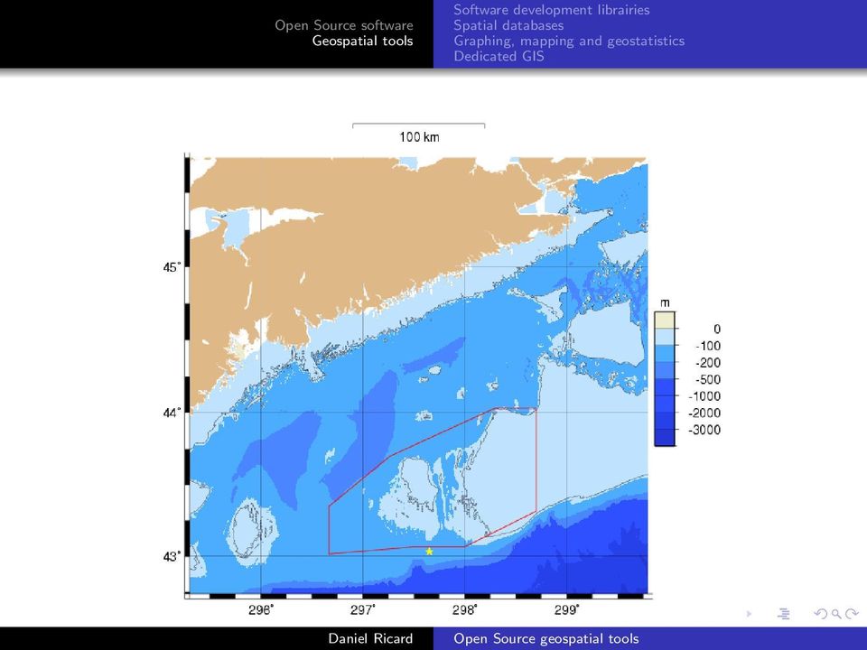
15 Demo of OSS geospatial tools Linux 2.6 kernel - Ubuntu breezy (Debian-based distribution) little movie of the Scotian Shelf maps made in GMT 4.1b conversion to bitmap images handled by ImageMagick movie file made using mencoder database of DFO and NMFS groundfish surveys and closed areas PostGIS on PostgreSQL with GEOS and proj libraries Quantum GIS 0.7.3

An Introduction to Open Source Geospatial Tools
 An Introduction to Open Source Geospatial Tools by Tyler Mitchell, author of Web Mapping Illustrated GRSS would like to thank Mr. Mitchell for this tutorial. Geospatial technologies come in many forms,
Open Source GIS The Future?
 Open Source GIS The Future? Daniel Morissette DM Solutions Group Inc. Open Source Licensing No licensing costs Unlimited rights to: Use the software View and analyse the source Copy, reuse in other systems
System requirements. Java SE Runtime Environment(JRE) 7 (32bit) Java SE Runtime Environment(JRE) 6 (64bit) Java SE Runtime Environment(JRE) 7 (64bit)
 7 (32bit) Java SE Runtime Environment(JRE) 6 (64bit) Java SE Runtime Environment(JRE) 7 (64bit)") Hitachi Solutions Geographical Information System Client Below conditions are system requirements for Hitachi Solutions Geographical Information System Client. 1/5 Hitachi Solutions Geographical Information
Hitachi Solutions Geographical Information System Client Below conditions are system requirements for Hitachi Solutions Geographical Information System Client. 1/5 Hitachi Solutions Geographical Information
Using SAS ACCESS to retrieve and store data in relational database management systems
 Using SAS ACCESS to retrieve and store data in relational database management systems Department of Biology Dalhousie University SHRUG meeting, February 23rd 2007 Disclaimer Background SAS is the only
Open Source GIS. Open Source GIS. Agenda. Open Source. Typische GIS Funktionen. LOTS Bern 18.2.05
 Agenda LOTS Bern 18.2.05 Pirmin Kalberer Sourcepole AG, Bad Ragaz www.sourcepole.ch Typische GIS Anwendungen Datenformate und GIS-Datenbanken Standards & Protokolle Bibliotheken & Applikationen Fragen
GeoKettle: A powerful open source spatial ETL tool
 GeoKettle: A powerful open source spatial ETL tool FOSS4G 2010 Dr. Thierry Badard, CTO Spatialytics inc. Quebec, Canada [email protected] Barcelona, Spain Sept 9th, 2010 What is GeoKettle? It is
Institute of Natural Resources Departament of General Geology and Land use planning Work with a MAPS
 Institute of Natural Resources Departament of General Geology and Land use planning Work with a MAPS Lecturers: Berchuk V.Y. Gutareva N.Y. Contents: 1. Qgis; 2. General information; 3. Qgis desktop; 4.
Open Source GIS Blitz!
 Open Source GIS Blitz! Startwiththisvideo http://vimeo.com/2598878 Openstreetmap.org Crown copyright no expiration all government map data in England. Rest of Europe not much better Volunteer mapping effort.
Web and Mobile GIS Applications Development
 Web and Mobile GIS Applications Development Presented by : Aamir Ali Manager Section Head (GIS Software Customization) Pakistan Space and Upper Atmosphere Research Commission (SUPARCO) Geographical Information
Institute of Computational Modeling SB RAS
 Institute of Computational Modeling SB RAS ORGANIZATION OF ACCESS TO OBSERVATIONAL DATA USING WEB SERVICES FOR MONITORING SYSTEMS THE STATE OF THE ENVIRONMENT Kadochnikov Aleksey A. Russia, Krasnoyarsk
An Android based Quantum GIS prototype. Ramon Carrillo, Daniel Ochoa [email protected]
 An Android based Quantum GIS prototype Ramon Carrillo, Daniel Ochoa [email protected] Summary Background Past works Quantum GIS Mobile Quantum GIS Results Future works Background Robotic and computer
Software, Shareware and Opensource CSCU9B2
 Software, Shareware and Opensource CSCU9B2 1 Contents Commercial software vs Freeware vs Open Source software Licences GNU GPL Open source Common software examples Sources, Safety and Risks 2 Pay, Try,
Basics on Geodatabases
 Basics on Geodatabases 1 GIS Data Management 2 File and Folder System A storage system which uses the default file and folder structure found in operating systems. Uses the non-db formats we mentioned
 Development tools to create Web-GIS applications DbMAP ASJ the best solution to easily publish GIS data from existing spatial databases and distributed GIS data sources Easily designs, produces, and publishes
Web Mapping in Archaeology
 Non-invasive methods in the contemporary archaeological practice 25th February 2014 http://www.pborycki.pl/pdf/webmapping.pdf Plan of the presentation 1 Web Mapping General Idea History of Web Mapping
Open Source Geospatial Software. Bob Bruce, P.Eng Mapping and Lands Branch, Manitoba Conservation WWW.HWPS.CA [email protected]
 A Survey of Open Source Geospatial Software Bob Bruce, P.Eng Mapping and Lands Branch, Manitoba Conservation WWW.HWPS.CA [email protected] APEGM PD Breakfast Tuesday, 12 June 2007 access this presentation
City of Tigard. GIS Data Standards
 City of Tigard GIS Data Standards City of Tigard 13125 SW Hall Blvd Tigard, Oregon 97223 503 639-4171 Page 1 of 5 1.0 Purpose The purpose of these standards is to provide guidance for geospatial data development
Pennsylvania Geospatial Data Sharing Standards (PGDSS) V 2.5
 V 2.5") Submitted to: Pennsylvania Geospatial Data Sharing Standards (PGDSS) V 2.5 Spatial Data Migration Tools Report May 2, 2007 Table of Contents 1.0 Document Purpose...B-1 2.0 Overview of Spatial Data Migration
Submitted to: Pennsylvania Geospatial Data Sharing Standards (PGDSS) V 2.5 Spatial Data Migration Tools Report May 2, 2007 Table of Contents 1.0 Document Purpose...B-1 2.0 Overview of Spatial Data Migration
Choosing the right GIS framework for an informed Enterprise Web GIS Solution
 13 ANNUAL INTERNATIONAL CONFERENCE AND EXHIBITION ON GEOSPATIAL INFORMATION TECHNOLOGY AND APPLICATIONS Epicentre; Gurgaon, India; 19-21 January, 2010 Choosing the right GIS framework for an informed Enterprise
Reading & Writing Spatial Data in R John Lewis. Some material used in these slides are taken from presentations by Roger Bivand and David Rossiter
 Reading & Writing Spatial Data in R John Lewis Some material used in these slides are taken from presentations by Roger Bivand and David Rossiter Introduction Having described how spatial data may be represented
Iraklis Karampourniotis, Zoi Arvanitidou, Ioannis Paraschakis. Using open source software in gis training and education
 Iraklis Karampourniotis, Zoi Arvanitidou, Ioannis Paraschakis Using open source software in gis training and education Can open source be used? The question troubling us was Can Open Source Software be
ARCHITECTURE OF INTEGRATED GIS AND GPS FOR VEHICLE MONITORING
 1 st Logistics International Conference Belgrade, Serbia 28-30 November 2013 ARCHITECTURE OF INTEGRATED GIS AND GPS FOR VEHICLE MONITORING Adela B. Crnišanin * State University of Novi Pazar, Department
Cookbook 23 September 2013 GIS Analysis Part 1 - A GIS is NOT a Map!
 Cookbook 23 September 2013 GIS Analysis Part 1 - A GIS is NOT a Map! Overview 1. A GIS is NOT a Map! 2. How does a GIS handle its data? Data Formats! GARP 0344 (Fall 2013) Page 1 Dr. Carsten Braun 1) A
Unified Infrastructure Management Compatibility Matrix April 4, 2016
 Unified Infrastructure Management Compatibility Matrix April 4, 2016 1 Unified Infrastructure Management Compatibility Matrix- CA Technologies Legal Notices Copyright 2016, CA. All rights reserved. Warranty
Design/build and visualization of political and social-statistics. statistics geodatabase by open source tools
 Design/build and visualization of political and social-statistics statistics geodatabase by open source tools Ferenc Speiser Post-graduate distance learning course in Geoinformatics Contents The goals
DEVELOPMENT AND COMPARISON OF OPEN SOURCE BASED WEB GIS FRAMEWORKS ON WAMP AND APACHE TOMCAT WEB SERVERS
 DEVELOPMENT AND COMPARISON OF OPEN SOURCE BASED WEB GIS FRAMEWORKS ON WAMP AND APACHE TOMCAT WEB SERVERS Sonam Agrawal a, Rajan Dev Gupta b a GIS Cell, Motilal Nehru National Institute of Technology, Allahabad-211004,
Creating a GIS based learning tool for the Faculty of Forest & Environment at the HNE Eberswalde
 Creating a GIS based learning tool for the Faculty of Forest & Environment at the HNE Eberswalde G. Singelnstein / H. Plesse University of Applied Sciences in Eberswalde 14.04.2011 Introduction I What
GIS Databases With focused on ArcSDE
 Linköpings universitet / IDA / Div. for human-centered systems GIS Databases With focused on ArcSDE Imad Abugessaisa [email protected] 20071004 1 GIS and SDBMS Geographical data is spatial data whose
Standards based spatial data management, GIS and web mapping. Spatial data management, analysis & sharing the free & easy way!
 or Spatial data management, analysis & sharing the free & easy way! Premise: Traditional GIS is inherently flawed, especially when it comes to many fisheries/maritime datasets Premise: Traditional GIS
SQL SUPPORTED SPATIAL ANALYSIS FOR WEB-GIS INTRODUCTION
 SQL SUPPORTED SPATIAL ANALYSIS FOR WEB-GIS Jun Wang Jie Shan Geomatics Engineering School of Civil Engineering Purdue University 550 Stadium Mall Drive, West Lafayette, IN 47907 ABSTRACT Spatial analysis
PostGIS Data Integration
 PostGIS Data Integration & Display on SIS Alex Hill GIS Manager Contents Plus Dane Group who we are PostGIS Data Integration and Display on SIS What is a Spatial Database? What is PostgreSQL/PostGIS? Why
Intro to evis: the event visualization tool
 Intro to evis: the event visualization tool Background The of the (CBC) at the (AMNH) developed the Event Visualization Tool (evis), as a conservation monitoring and decision support tool for guiding protected
Introduction to GIS (Basics, Data, Analysis) & Case Studies. 13 th May 2004. Content. What is GIS?
 & Case Studies. 13 th May 2004. Content. What is GIS?") Introduction to GIS (Basics, Data, Analysis) & Case Studies 13 th May 2004 Content Introduction to GIS Data concepts Data input Analysis Applications selected examples What is GIS? Geographic Information
Introduction to GIS (Basics, Data, Analysis) & Case Studies 13 th May 2004 Content Introduction to GIS Data concepts Data input Analysis Applications selected examples What is GIS? Geographic Information
TerraAmazon - The Amazon Deforestation Monitoring System - Karine Reis Ferreira
 TerraAmazon - The Amazon Deforestation Monitoring System - Karine Reis Ferreira GEOSS Users & Architecture Workshop XXIV: Water Security & Governance - Accra Ghana / October 2008 INPE National Institute
BACHELOR'S THESIS. GIS: using open source or commercial products
 BACHELOR'S THESIS 2008:025 HIP GIS: using open source or commercial products Jakob Normark Luleå University of Technology BSc Programmes in Engineering Computer Engineering Department of Skellefteå Campus
UK Location Programme
 Location Information Interoperability Board Data Publisher How To Guide Understand the background to establishing an INSPIRE View Service using GeoServer DOCUMENT CONTROL Change Summary Version Date Author/Editor
INTRODUCTION TO ARCGIS SOFTWARE
 INTRODUCTION TO ARCGIS SOFTWARE I. History of Software Development a. Developer ESRI - Environmental Systems Research Institute, Inc., in 1969 as a privately held consulting firm that specialized in landuse
Open Source Software Communities - Lessons Learnt
 1 Open Source Software Communities - Lessons Learnt Imed Hammouda, adjunct professor Alexander Lokhman, researcher Tampere University of Technology 25.2.2011 Open Source vs. Free Software 2 Free software
Future Trends in Geospatial Data Management Process Squadron Leader Mudit Mathur
 VOL 2 ISSUE 5 24 TOWARDS A NATIONAL SPATIAL DATA INFRASTRUC- TURE (NSDI) Dr. Talal Al-Awadhi 28 GEODATABASE FOR URBAN DESIGN AND PLANNING Simon Yanuar PUTRA 34 FREE, CHEAP, AND POW- ERFUL POSTGIS, THE
The State of Free GIS in 2012. Estado de la tecnica de GIS/SIG libre 2012
 The State of Free GIS in 2012 Estado de la tecnica de GIS/SIG libre 2012 (SIG Sistema de Informacion Geografica) Stefan Steiniger [email protected] 1 / 253 Quien.... conoce software libre?. conoce el
J9.6 GIS TOOLS FOR VISUALIZATION AND ANALYSIS OF NEXRAD RADAR (WSR-88D) ARCHIVED DATA AT THE NATIONAL CLIMATIC DATA CENTER
 ARCHIVED DATA AT THE NATIONAL CLIMATIC DATA CENTER") J9.6 GIS TOOLS FOR VISUALIZATION AND ANALYSIS OF RADAR (WSR-88D) ARCHIVED DATA AT THE NATIONAL CLIMATIC DATA CENTER Steve Ansari * STG Incorporated, Asheville, North Carolina Stephen Del Greco NOAA National
J9.6 GIS TOOLS FOR VISUALIZATION AND ANALYSIS OF RADAR (WSR-88D) ARCHIVED DATA AT THE NATIONAL CLIMATIC DATA CENTER Steve Ansari * STG Incorporated, Asheville, North Carolina Stephen Del Greco NOAA National
Open Source Tools for Spatial Analysis and Geoprocessing
 Open Source Tools for Spatial Analysis and Geoprocessing on the Desktop Karsten Vennemann www.terragis.net Seattle, WA, USA [email protected] 206 905 1711 Workshop Outline Introduction to Free and Open
Enterprise GIS Solutions to GIS Data Dissemination
 Enterprise GIS Solutions to GIS Data Dissemination ESRI International User Conference July 13 17, 2009 Wendy M. Turner Senior GIS Engineer & Program Manager Freedom Consulting Group, LLC Building the Enterprise
Nimsoft Monitor Compatibility Matrix October 17, 2013
 Nimsoft Monitor Compatibility Matrix October 17, 2013 1 Nimsoft Monitor Compatibility Matrix Legal Notices Copyright 2013, CA. All rights reserved. Warranty The material contained in this document is provided
Supported Platforms. HP Vertica Analytic Database. Software Version: 7.0.x
 HP Vertica Analytic Database Software Version: 7.0.x Document Release Date: 5/7/2014 Legal Notices Warranty The only warranties for HP products and services are set forth in the express warranty statements
NAS Storage needs to be purchased; Will not be offered IAAS - Utility SMTP Per SMTP account Per server
 Service Category Services UOM Remarks IAAS - Compute Small (1vCPU 2GB vram) per VM IAAS - Compute Medium (2vCPU 4GB vram) per VM IAAS - Compute Large (4vCPU 8GB vram) per VM IAAS - Compute XLarge (8vCPU
Analysis of the Free GIS Software Applications in respect to INSPIRE services and OGC standards
 Analysis of the Free GIS Software Applications in respect to INSPIRE services and OGC standards Authors: Francesco D'Alesio Peter Hopfgartner Paolo Viskanic June 2011 Executive Summary This document analyses
Documentation of open source GIS/RS software projects
 Contract no. Workpackage Delivery Delivery Date 030776 WP1 D1.6 2007-07-02 CASCADOSS Development of a trans-national cascade training programme on Open Source GIS&RS Software for environmental applications
Vertical Datums: An Introduction and Software Review
 Vertical Datums: An Introduction and Software Review Areas to Cover Theoretical Introduction Representation in EPSG Representation in OGC WKT Incorporation in PROJ.4 Incorporation in GDAL Future Work Introduction
Developing of A GIS Based Enviromental Monitoring System with Open Source Softwares
 L. Kottyán, G. Nagy, A. Szepes Developing of A GIS Based Enviromental Monitoring System with Open Source Softwares Developing of A GIS Based Enviromental Monitoring System with Open Source Softwares László
Introduction to OSGeo and QGIS
 Introduction to OSGeo and QGIS Arnulf Christl OSGeo President Emeritus ESTGIS Pühajärve, Estonia Arnulf Christl Geospatial Systems Architect OSGeo President Emeritus Director of the metaspatial Institute
County of Los Angeles. Chief Information Office Preferred Technologies for Geographic Information Systems (GIS) September 2014
 September 2014") County of Los Angeles Chief Information Office Preferred Technologies for Geographic Information Systems (GIS) September 2014 CIO Preferred Technologies for GIS This document lists the preferred Geographic
County of Los Angeles Chief Information Office Preferred Technologies for Geographic Information Systems (GIS) September 2014 CIO Preferred Technologies for GIS This document lists the preferred Geographic
Oracle Big Data Spatial and Graph
 Oracle Big Data Spatial and Graph Oracle Big Data Spatial and Graph offers a set of analytic services and data models that support Big Data workloads on Apache Hadoop and NoSQL database technologies. For
Of Penguins and Wildebeest. Anthony Rodgers VA7IRL
 Of Penguins and Wildebeest Anthony Rodgers VA7IRL The Penguin Linux was created by a Swedish-speaking Finn called Linus Torvalds Version 0.01 was released in September 1991 We are now on version 2.6 It
Free and Open Source Geospatial Tools for Environmental Modeling and Management
 Free and Open Source Geospatial Tools for Environmental Modeling and Management A. Jolma a, D.P. Ames b, N. Horning c, M. Neteler d, A. Racicot e and T. Sutton f a Helsinki University of Technology, Espoo,
4.1 Introduction 4.2 Explain the purpose of an operating system 4.2.1 Describe characteristics of modern operating systems Control Hardware Access
 4.1 Introduction The operating system (OS) controls almost all functions on a computer. In this lecture, you will learn about the components, functions, and terminology related to the Windows 2000, Windows
Measurably reducing risk through collaboration, consensus & practical security management. 2015 CIS Security Benchmarks 1
 Measurably reducing risk through collaboration, consensus & practical security management 2015 CIS Security Benchmarks 1 Background State of Idaho s Rights and Benefits as a CIS Security Benchmarks Member
Chapter 5 Spatial is not Special: Managing Tracking Data in a Spatial Database
 Chapter 5 Spatial is not Special: Managing Tracking Data in a Spatial Database Ferdinando Urbano and Mathieu Basille Abstract A wildlife tracking data management system must include the capability to explicitly
Chapter 6: Data Acquisition Methods, Procedures, and Issues
 Chapter 6: Data Acquisition Methods, Procedures, and Issues In this Exercise: Data Acquisition Downloading Geographic Data Accessing Data Via Web Map Service Using Data from a Text File or Spreadsheet
OSGeo Web Mapping Typification: GeoMajas, Mapbender, MapFish and OpenLayers. Christoph Baudson Arnulf Christl FOSS4G 2010 Barcelona
 OSGeo Web Mapping Typification: GeoMajas, Mapbender, MapFish and OpenLayers Christoph Baudson Arnulf Christl FOSS4G 2010 Barcelona Disclaimer All information contained in this presentation has been compiled
Supported Platforms. HP Vertica Analytic Database. Software Version: 7.1.x
 HP Vertica Analytic Database Software Version: 7.1.x Document Release Date: 10/14/2015 Legal Notices Warranty The only warranties for HP products and services are set forth in the express warranty statements
ArcGIS 10.1 Geodatabase Administration. Gordon Sumerling & Christopher Brown
 ArcGIS 10.1 Geodatabase Administration Gordon Sumerling & Christopher Brown Key Improvements at ArcGIS 10.1 1. Easier Administration through Graphic Interfaces 2. Greater Seamless integration with Open
Managing bathymetric data in a hydrographic survey company and making the data accessible to clients
 Managing bathymetric data in a hydrographic survey company and making the data accessible to clients Duncan Mallace 1 Tim Kearns 2 1NetSurvey Limited, 2A Banbury Office Village, Noral Way, Banbury, OX16
Analysing Big Data in ArcGIS
 OIL & GAS Analysing Big Data in ArcGIS AIS based risk modelling Esri European Petroleum GIS Conference 2014 Karl John Pedersen 7th November 2014 1 DNV GL 2014 7th November 2014 SAFER, SMARTER, GREENER
Building a Spatial Database in PostgreSQL
 Building a Spatial Database in PostgreSQL David Blasby Refractions Research [email protected] http://postgis.refractions.net Introduction PostGIS is a spatial extension for PostgreSQL PostGIS aims
GeoKettle: A powerful spatial ETL tool for feeding your Spatial Data Infrastructure (SDI)
") GeoKettle: A powerful spatial ETL tool for feeding your Spatial Data Infrastructure (SDI) Dr. Thierry Badard, CTO [email protected] Spatialytics http://www.spatialytics.com FOSS4G 2011 Workshop,
GeoKettle: A powerful spatial ETL tool for feeding your Spatial Data Infrastructure (SDI) Dr. Thierry Badard, CTO [email protected] Spatialytics http://www.spatialytics.com FOSS4G 2011 Workshop,
Open source geospatial Business Intelligence (BI) in action!
 in action!") Open source geospatial Business Intelligence (BI) in action! OGRS 2009 Nantes, France Dr. Thierry Badard Etienne Dubé Belko Diallo Jean Mathieu Mamadou Ouattara GeoSOA research group Centre for Research
Open source geospatial Business Intelligence (BI) in action! OGRS 2009 Nantes, France Dr. Thierry Badard Etienne Dubé Belko Diallo Jean Mathieu Mamadou Ouattara GeoSOA research group Centre for Research
Google Earth Digitale Wege in eine bekannte Welt Sep. 2006
 Google Earth Digitale Wege in eine bekannte Welt Sep. 2006 Joachim Glaubrecht Google Enterprise [email protected] What is Google Enterprise? 2 1 Focus.de: "Der Papst-Besuch in Google Earth" 3 How to Geo
Introduction to PostGIS
 Tutorial ID: IGET_WEBGIS_002 This tutorial has been developed by BVIEER as part of the IGET web portal intended to provide easy access to geospatial education. This tutorial is released under the Creative
PrimeRail Installation Notes Version A-2008.06 June 9, 2008 1
 PrimeRail Installation Notes Version A-2008.06 June 9, 2008 1 These installation notes present information about installing PrimeRail version A-2008.06 in the following sections: Media Availability and
Dell NetVault Backup. Compatibility Guide
 Dell NetVault Backup 2015 Dell Inc. ALL RIGHTS RESERVED. This guide contains proprietary information protected by copyright. The software described in this guide is furnished under a software license or
REAL-TIME DATA GENERALISATION AND INTEGRATION USING JAVA
 REAL-TIME DATA GENERALISATION AND INTEGRATION USING JAVA Lars Harrie and Mikael Johansson National Land Survey of Sweden SE-801 82 Gävle [email protected], [email protected] KEY WORDS:
AutoForm plus R6 Stand-alone Products: System Requirements
 AutoForm plus R6 Stand-alone : System Requirements Front-End Components (AutoForm User Interface and Front-End Modules) Back-End Components (Solver) License Server (RLM) - Screen resolution: 1920x1080
SUMMER SCHOOL ON ADVANCES IN GIS
 SUMMER SCHOOL ON ADVANCES IN GIS Six Workshops Overview The workshop sequence at the UMD Center for Geospatial Information Science is designed to provide a comprehensive overview of current state-of-the-art
A Web services solution for Work Management Operations. Venu Kanaparthy Dr. Charles O Hara, Ph. D. Abstract
 A Web services solution for Work Management Operations Venu Kanaparthy Dr. Charles O Hara, Ph. D Abstract The GeoResources Institute at Mississippi State University is leveraging Spatial Technologies and
A WEB GIS FOR WETLANDS OF KERALA USING OPEN SOURCE GEOSPATIAL SOFTWARE. Santosh Gaikwad* and S Narendra Prasad**
 A WEB GIS FOR WETLANDS OF KERALA USING OPEN SOURCE GEOSPATIAL SOFTWARE Santosh Gaikwad* and S Narendra Prasad** Salim Ali Centre for Ornithology and Natural History Deccan Regional Station, Hyderabad *[email protected]
Dell NetVault Backup. Compatibility Guide
 Dell NetVault Backup 2014 Dell Inc. ALL RIGHTS RESERVED. This guide contains proprietary information protected by copyright. The software described in this guide is furnished under a software license or
Introduction to Using PostGIS Training Workbook Last Updated 18 June 2014
 Introduction to Using PostGIS Training Workbook Last Updated 18 June 2014 Prepared by: Simon Nitz, Senior Technical Consultant Digital Mapping Solutions NZ Limited 2nd Floor, 20 Bridge Street, Ahuriri,
Open Source Desktop GIS Solutions for the Not-So Casual User
 Open Source Desktop GIS Solutions for the Not-So Casual User Roger C. Lowe III Warnell School of Forestry and Natural Resources The University of Georgia Athens, GA 30605 [email protected] Abstract Ask
Migration and Developer Productivity Solutions Retargeting IT for Emerging Business Needs
 Migration and Developer Productivity Solutions Retargeting IT for Emerging Business Needs Charles Finley Transformix Computer Corporation Who We Are Transformix provides software solutions and services
Managing a Geographic Database From Mobile Devices Through OGC Web Services
 Managing a Geographic Database From Mobile Devices Through OGC Web Services Nieves R. Brisaboa 1, Miguel R. Luaces 1, Jose R. Parama 1, and Jose R. Viqueira 2 1 Database Laboratory, University of A Coruña,
Microsoft Windows Apple Mac OS X
 Products Snow License Manager Snow Inventory Server, IDP, IDR Client for Windows Client for OSX Client for Linux Client for Unix Oracle Scanner External Data Provider Snow Distribution Date 2014-02-12
HANDS-ON WORKSHOP TOOLS FOR SPATIAL DATA VISUALIZATION: Using selected Open Source tools and Open Data to visualize your own spatial data
 HANDS-ON WORKSHOP TOOLS FOR SPATIAL DATA VISUALIZATION: Using selected Open Source tools and Open Data to visualize your own spatial data Barend Köbben Version 1.0 December 12, 2012 Contents 1 Open Data:
Standardized data sharing through an open-source Spatial Data Infrastructure: the Afromaison project
 Standardized data sharing through an open-source Spatial Data Infrastructure: the Afromaison project Yaniss Guigoz - University of Geneva/GRID-Geneva 1 EcoARM2ERA and AFROMAISON Why Afromaison in this
Operating Systems (Linux)
") G51CSA Computer Systems Architecture Operating Systems (Linux) Red Hat Jon Masters About the speaker Jon Masters is a Senior Software Engineer at Red Hat History in embedded devices with
G51CSA Computer Systems Architecture Operating Systems (Linux) Red Hat Jon Masters About the speaker Jon Masters is a Senior Software Engineer at Red Hat History in embedded devices with
CSCA0101 Computing Basics CSCA0101 COMPUTING BASICS. Chapter 7 Software
 CSCA0101 COMPUTING BASICS Chapter 7 1 1. Computer Application 2. Types of Computer 3. Licensing 4. Types of License 5. Piracy 2 Computer software, or just software, is a collection of computer programs
JNCC Report No: 542. QGIS Suitability Assessment. Claire E. Lush & Mike J. Lush. November 2014. JNCC, Peterborough 2014 ISSN 0963 8901
 JNCC Report No: 542 QGIS Suitability Assessment Claire E. Lush & Mike J. Lush November 2014 JNCC, Peterborough 2014 ISSN 0963 8901 For further information please contact: Joint Nature Conservation Committee
Building Geospatial Business Intelligence Solutions with Free and Open Source Components
 Building Geospatial Business Intelligence Solutions with Free and Open Source Components FOSS4G 2007 Etienne Dubé Thierry Badard Yvan Bédard Centre for Research in Geomatics Université Laval, Québec, Canada
Spatial Database Support
 Page 1 of 11 Spatial Database Support Global Mapper can import vector data from and export vector data to the following spatial databases: Esri ArcSDE Geodatabase Esri File Geodatabase Esri Personal Geodatabases