Vertical Datums: An Introduction and Software Review
|
|
|
- Kelly Lloyd
- 8 years ago
- Views:
Transcription
1 Vertical Datums: An Introduction and Software Review

2 Areas to Cover Theoretical Introduction Representation in EPSG Representation in OGC WKT Incorporation in PROJ.4 Incorporation in GDAL Future Work

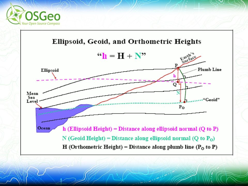
3 Introduction to Vertical Datums Basis for measuring elevation values. Generally 0 is roughly sea level Often local and national datums exist. Three Classes of Vertical Datums > Ellipsoidal > Orthometric > Tidal

4 Ellipsoidal Vertical Datums Height is measured from the ellipsoid. Height is normal to the ellipsoid surface Ellipsoid positioning determined by horizontal datum. Traditional GIS height model. eg. NAD83, WGS84, ITRF90

5 Tidal Datums Based on observations of water levels. Means computed over a stated time period (often a 19 year epoch) Affected by various physical factors (wind,etc) eg. > LMSL (Local Mean Sea Level) > MLW (Mean Low Water)
 eg.")
6 Orthometric Vertical Datums Height is measured from the Geoid Measured along a plumb line Many national and regional implementations: > NGVD29 (National Geodetic Vertical Datum 1929) > NAVD88 (North American Vertical Datum 1988) > IGLD85 (International Great Lakes Datum of 1985)
 > IGLD85 (International")
7 Geoid Equipotential gravity surface Least squares best fit with global mean sea level Undulates significantly due to mountains, rock density, etc. Varies by up to 100m from geocentric ellipsoid Various approximations available based on physical readings and interpolation. eg USA Geoid2003, global EGM 96

8

9
10 Vertical Coordinates in EPSG Compound Coordinate Reference System (crs table): Horizontal CRS (ie. UTM 11 WGS84) Vertical CS (ie. NAVD88) Vertical Coordinate Reference System (crs table): Vertical Datum Linear Units Axis (direction)
 Vertical Coordinate Reference System (crs table):")
11 Vertical Coordinates in EPSG Vertical Datums (datum table): Area of use, comments, etc. Transformations: Based on Vertical CRS Often many defined for one Vertical CRS. Many transformation methods defined. No obvious pivot vertical datum

12 EPSG Transformation Methods Simple offset (ie. Baltic Sea vs. Black Sea) Offset+Slope (spatial slope) Grid Shift Files (VERTCON, geoid, many distinct transformation methods) Others I don't understand and haven't reviewed

13 OGC Well Known Text Representation COMPD_CS["OSGB36 / British National Grid + ODN", PROJCS["OSGB 1936 / British National Grid", GEOGCS["OSGB 1936", DATUM["OSGB_1936",... AUTHORITY["EPSG","27700"]], VERT_CS["Newlyn", VERT_DATUM["Ordnance Datum Newlyn",2005, AUTHORITY["EPSG","5101"]], UNIT["metre",1,AUTHORITY["EPSG","9001"]], AXIS["Up",UP], AUTHORITY["EPSG","5701"]], AUTHORITY["EPSG","7405"]]
![.. AUTHORITY["EPSG","27700"]], VERT_CS["Newlyn", VERT_DATUM["Ordnance Datum Newlyn",2005,](/docs-images/40/12553764/images/page_13.jpg "AUTHORITY[\"EPSG\",\"5101\"]], UNIT[\"metre\",1,AUTHORITY[\"EPSG\",\"9001\"]], AXIS[\"Up\",UP],")
14 OGC Notes No TOWGS84[] comparable method to represent transformations. VERT_DATUM type has no equivalent in EPSG Ellipsoidal vertical datums not COMPD_CS

15 Liblas Vertical Datum Support Liblas is a LAS (Lidar format) library (liblas.org) Funding from US ACE via Howard Butler for vertical datum support Liblas uses PROJ.4, libgeotiff, GDAL for coordinate system handling Goal: > Las2las -t_srs NAD83+NAVD88 in.las out.las

16 Libgeotiff Changes Modify the build_pcs.py script to produce: > vertcs.csv vertical crs + transformation > compdcs.csv compound crs list > primarily for use of GDAL EPSG lookups Clarify representation of vertical crs: > VerticalCSTypeGeoKey > VerticalDatumGeoKey > No equivalent to compound crs

17 GDAL Changes Complete: ImportFromEPSG() support for VERT_CS ImportFromEPSG() support for COMPD_CS gtx (vertical grid shift format) read/write To Do: to/from Proj.4 vertical grid shift parameters WKT EXTENSION for vertical shift parameters VERT_CS, COMPD_CS verification

18 PROJ.4 Changes Done: +geoidgrid= parameter.gtx vertical grid shift reader Ellipsoidal vertical datum conversion To Do: Chaining +geoidgrid=? Compound crs in epsg init file? Vertical offsets?

19 Notes WGS84 ellipsoidal as pivot vertical datum.gtx picked as vertical datum format Translate to gtx with GDAL Convert longitude files to -180 to 180 NOAA VDatum used extensively for tutorial materials, grid shift files and validation

20 Software Review Not Comprehensive, or Accurate! CSMap (Autodesk/Mentor): Includes support for geoid using gtx Many gtx files distributed with software GeoToolbox (Java): Support COMPD_CS WKT Geoid transform can be requested specifically (using spherical harmonics model)

21 Conclusions Ellipsoidal datums ok for many GIS purposes Geoid needed for many formal vertical datums (such as NAVD88) Vertical datums particularly important on coast Word underway to incorporate support in liblas, libgeotiff, GDAL and PROJ.4.