Building a Spatial Database for Earthquake Risk Assessment and Management in the Caribbean
|
|
|
- Hope Phillips
- 10 years ago
- Views:
Transcription
1 Building a Spatial Database for Earthquake Risk Assessment and Management in the Caribbean Jacob Opadeyi and Rehanna Jadoo Department of Geomatics Engineering and Land Management, The University of the West Indies, St. Augustine, Trinidad, West Indies. [email protected]

2 OUR VULNERABLE LAND MASS Housing developments on drainage channels and steep slopes Unapproved development and land squatting Voluntary approach to the use of building codes Active seismic activities with geological faults Low level of awareness on the impact of natural hazards Low level of real estate insurance

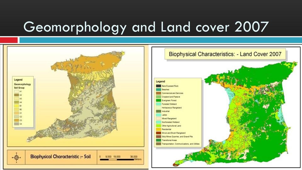
3 Geomorphology and Land cover 2007
4 Roads and Building Density

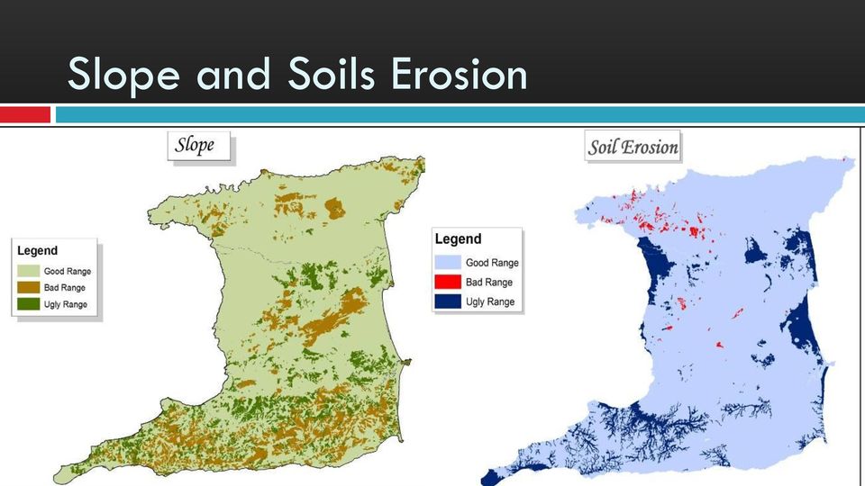
5 Slope and Soils Erosion
6 THE CONSEQUENCES
7 Damage to Buildings in Haiti due to the Earthquake of 2010

8 Risk Management Framework Risk management Description of intention Hazard mapping Risk evaluation Vulnerability assessment Risk estimation Estimation of probability of consequences Estimation of magnitude of consequences

9 EARTHQUAKE RISK ASSESSMENT What is Risk? Risks are an integral part of life and since risk cannot be completely eliminated, the only possible option is to assess and manage it. The first step in risk assessment is to find out what the problems are. This involves evaluating the significance of a given quantitative measure of risk in an integrated way.

10 EARTHQUAKE RISK ASSESSMENT Earthquake risk assessment encompasses the range of studies required to estimate the likelihood and potential consequences of a specific set of earthquakes of different magnitudes and intensities. Seismic scientists and engineers provide the key decision-makers with a description of the nature of the earthquake risk in specific regions as well as the degree of uncertainty surrounding such estimates. Quantitative estimates of seismic risk are important for judging whether earthquakes represent a substantial threat at any location as they enable objective weighting of earthquake risk relative to other natural hazards and other priorities for making design and retrofit decisions (NRC, 1996.)

11 Methods 4 major steps (Batuk et al 2005) 1. Hazard Analysis quantifies the physical characteristics of a hazard, including probability of occurrence, magnitude, intensity, location, influence of geological factors 2. Exposure Analysis identifies and maps underlying elements at risk or exposures, including the built environment and socioeconomic factors such as population and economic activity 3. Vulnerability Analysis: Assesses the degree of susceptibility to which elements at risk are exposed to the hazard. A common form of vulnerability analysis uses historical damage records to prescribe relationships between damage to dwellings and hazard intensity, for example different buildings and construction types will have distinct vulnerability curves, and finally 4. Risk analysis synthesizes the above three components and determines the resulting losses as a function of return period or as an exceedance probability: e.g. RISK ($$/YR) = SUM( HAZARD [YEAR -1 ] X ASSETS [$$] X FRAGILITY [0-1])

12 Uses of Earthquake Risk Assessment (C. Benson and J. Twigg, 2004) Predicting the expected impact of earthquakes Identification of appropriate risk management strategies Predicting the impact a project would have on forms and level of vulnerability in the wider community Help to formulate national policy objectives such as land use planning and building codes it provides cost efficient decision support on how to optimize investments into risk reducing measures in three situations, namely, prior, during and after an earthquake.

13 Data Required for Earthquake Risk Assessment A. Baseline data - Administrative boundary - Land cover, roads, streams etc. - Transportation and utility system - Facility and building structures - Demography (census, population distribution, density) - Economic value of asset of various sectors
 - Economic value of")
14 Data Required for Earthquake Risk Assessment B. Hazard data Historical records (time, place, extent, magnitude / intensity) of earthquake hazard Geology, lithology, soil, and slope, water table Faults location, length, and depth Site condition, ground motion Existing method in hazard & risk assessment methodology

15 Data Required for Earthquake Risk Assessment C. Vulnerability data Proximity of assets to active and inactive fault lines Age of structures Population and development density Value of assets Location of critical facilities: Hospitals, Schools, Prisons, Banks, Public offices Construction materials used in buildings Location of lifelines: telecommunication, water, gas, power, transport systems

16 EARTHQUAKE RISK MANAGEMENT What is Risk Management? Risk management means reducing the threats to life, property and the environment posed by the hazard whilst simultaneously accepting unmanageable risks and maximizing any associated benefits (Smith, 1996.) Risk management involves the efforts of a variety of sectors and series of actions. In the case of earthquakes, risk management describes the role of seismic monitoring in developing alternative strategies for reducing future losses and aiding the recovery process.
 Risk management involves the efforts of a variety of sectors and series of actions.")
17 Earthquake Risk Management Measures National risk reduction program Disaster preparedness and response plans Disaster recovery plans (National and sectoral) Earthquake hazard maps Earthquake early warning systems Landuse planning Building codes and development regulations Insurance schemes Development incentive programmes Efficient risk communication strategies Public education (use of simulators) Research and development programmes Earthquake risk policy and legislation
 Research and development programmes Earthquake risk")
18 Example of Seismic Assessment Products Figure 1 Colour Coded Seismic Hazard Map pubs.usgs.gov/fs/2003/fs017-03/images/useqs.gif; Figure 2 Source: Figure 3Source: Seismic risk mapping in Germany, Tyagunov et al 2006

19 Case Study: Comprehensive Earthquake Risk Reduction Program and Action Plan: Marikina Task 1. Stakeholder User Needs Assessment: The first task will identify primary stakeholder concerns and interests. Using available GIS data and scenario modeling, it characterized stakeholder concerns in terms of known earthquake risk to valued community assets. Task 2. Data Inventory Comparison of existing GIS data resources with needs emerging from Task 1 Analyzes data collection and integration issues. Task 3. Risk Assessment Formalization of findings from a risk assessment regarding loss of housing, critical infrastructure, and economic development opportunities resulting from a 7.0 Magnitude earthquake.

20 Peak Ground Acceleration Map Overlaid on landuse to show areas subject to Heavy Shaking

21 Peak Ground Acceleration Map & Critical Facilities Subject to Heavy Shaking
22 Comprehensive Earthquake Risk Reduction Program and Action Plan: Marikina Task 4. Prepare Conceptual Earthquake Risk Reduction Plan. This task created a conceptual framework based on a strategic planning process It assesses implementation options for the Comprehensive Earthquake Risk Reduction Program including locally feasible goals and objectives, policies/strategies and programs/projects for mitigation, preparedness, response, and recovery.
23 Comprehensive Earthquake Risk Reduction Program and Action Plan: Marikina Task 5. Plan Refinement and Implementation Strategy This task combined objectives, policies, strategies, programs and projects for mitigation, preparedness, response, and recovery actions into a Draft Comprehensive Earthquake Risk Reduction Program and Action Plan based on discussions held at stakeholders workshop. Task 6. Produce Final Products This task will include finalization of the Program and Action Plan along with Web-based materials.
24 Feature Identity Database The feature identity database is made up of variables that provide general information about the facility e.g. location, name, contact information, name of person in charge etc. Many of these variables can be collected in the field using mobile GPS/GIS technology. Fac_ID P_KEY Nfac_ Code Health center Fac_Type Name Address Locality Tel Fax Chaguanas District Health Facility Corner Galt St. and Chaguanas Main Rd. Chaguanas Police Station Chaguanas Police Station Railway Rd. Chaguanas National Helicopter Services Air Field / Runway Ltd. NHSL Heliport, Camden Couva XX XXXXXXXXX XXXXXXXXXXXXXXXXXXX XXXXXXXXXXXXXXXXXXXXXX XXXXX XXXXXXX XXXXXX 27 XX XXXXXXXXX XXXXXXXXXXXXXXXXXXX XXXXXXXXXXXXXXXXXXXXXX XXXXX XXXXXXX XXXXXX 28 XX XXXXXXXXX XXXXXXXXXXXXXXXXXXX XXXXXXXXXXXXXXXXXXXXXX XXXXX XXXXXXX XXXXXX
25 Feature Amenities Database The feature amenities database is made up of variables that provide information about the facility s service amenities. This data should be collected by the relevant agency (government / private) responsible for the facility. Amen _ID Fac_ID F_KEY Floor_space Parking_sp Parking_ sz Generator Water _cap Pump YES XXX YES XX 24 XXXXXXXXXX XX XXXXXX YES XXX YES XX 25 XXXXXXXXXX XX XXXXXX YES XXX YES XX 26 XXXXXXXXXX XX XXXXXX 27 XXXXXXXXXX XX XXXXXX 28 XXXXXXXXXX XX XXXXXX Toilets_ unisex
26 Feature Functions Database The feature functions database is made up of variables that provide information about the facility s operations. These variables will depend on the type of facility. For example, the variables for a medical facility will include : Number of beds, Number of doctors, Number of nurses etc. This data should be collected by the relevant agency (government / private) responsible for the facility. Fac_ID P_KEY Health_ Beds N_Doctors N_Nurses N_Ambulances N_Drivers T_staff XXX XXX XX XX XXXX 136 XXX XXX XX XX XXXX 95 XXX XXX XX XX XXXX 200 XXX XXX XX XX XXXX
27 Structural Integrity Database The structural integrity database is made up of variables that provide information about the integrity of the facility s construction design. This data should be compiled by engineering, construction and inspection experts, in coordination with the relevant agency (government / private) responsible for the facility. Examples of variables that should be included and assessed include vulnerability of building foundation, columns, beams, supporting walls etc.
28 Structural Integrity Database These variables can be further broken down into more detailed evaluations and tests as deemed necessary by relevant experts. This information can be used to asses the facility s structural vulnerability to the effects of earthquakes or other natural disasters. Struc Fac_ID Found_v Column_ Supp_walls Beam Floor_slab yrs_safe _ID F_KEY uln vuln _vuln _vuln _vuln _usage XX XXX XXX XX XX XXXX Damage _history Earthquake Response Possible closure_reccom XX XXX XXX XX XX XXXX XX XXX XXX XX XX XXXX XX XXX XXX XX XX XXXX
29 Compiling the National Built Assets Database Feature Amenities Database Feature Identity Database Chaguanas District Health Center FAC_ID 23 Feature Functions Database Structural Integrity Database


30 Synchronization of Data with ArcGIS Hyperlink images of facility and building plans. Front View Side View 1 st Floor 2 nd Floor 3 rd Floor
31 Query & Analyse National Database of Built Assets Many questions can be answered by querying and analysing this database, along with the associated bio-physical characteristics of the land, providing decision-support for policymakers: How many built assets throughout the country require seismic retrofitting? Which facilities have been designated as shelters in the event of a natural disaster? Where are these shelters located? What is the potential monetary loss/replacement cost should one/more of these built assets collapse due to an earthquake? Which facilities exist within the most hazardous zones? In the event of an evacuation how many occupants will require special assistance?
32 Building Density in Anguilla
33 Building Density in Antigua
34 Building Density in Tortola
35 What are the Challenges facing the Development of Earthquake Risk Assessment and Management in Trinidad & Tobago? Lack of a consistent data collection programme for risk assessment and management. Lack of an active public education programme. A need for capacity development and enhancement Review of relationship with related agencies Lack of a database on building structures Vulnerability assessment of communities Obtaining political support
36 Thank you
Building Caribbean GeoNode Platform in Support of Climate Risk Management Jacob Opadeyi, PhD
 Building Caribbean GeoNode Platform in Support of Climate Risk Management Jacob Opadeyi, PhD Our Highly Vulnerable Region Housing developments on drainage channels and steep slopes Unapproved development
Disaster Risk Assessment:
 Disaster Risk Assessment: Disaster Risk Mapping Dr. Jianping Yan Disaster Risk Assessment Specialist Session Outline Essentials on Risk Mapping Map scale, grid size, aggregation unit Requirements for Risk
Preparedness in the Southwest
 Preparedness in the Southwest Risk Assessment and Hazard Vulnerability Developed by The Arizona Center for Public Health Preparedness Cover Art www.azcphp.publichealth.arizona.edu Chapter 1 Importance
Keynote 2: What is Landslide Hazard? Inventory Maps, Uncertainty, and an Approach to Meeting Insurance Industry Needs
 Keynote 2: What is Landslide Hazard? Inventory Maps, Uncertainty, and an Approach to Meeting Insurance Industry Needs Jeffrey R Keaton Richard J Roth, Jr Amec Foster Wheeler Los Angeles, USA Consulting
Proposed Terms of Reference for EIA studies
 1 Proposed Terms of Reference for EIA studies Base line data collection will be collected for the Post-Monsoon season 2016 (September to November 2016) in study area and 10 kms radius from project site.
AFAD DEPREM DAİRESİ BAŞKANLIĞI TÜRKİYE KUVVETLİ YER HAREKETİ ve ÖN HASAR TAHMİN SİSTEMLERİ ÇALIŞMA GRUBU. (Rapid Estimation Damage)
") (Rapid Estimation Damage) AFAD-RED SYSTEM The technological advances in seismic instrumentation and telecommunication permit the development of rapid estimation of earthquake losses in order to enhance
(Rapid Estimation Damage) AFAD-RED SYSTEM The technological advances in seismic instrumentation and telecommunication permit the development of rapid estimation of earthquake losses in order to enhance
NATIONAL POLICY ON THE INCIDENT MANAGEMENT SYSTEM
 NATIONAL POLICY ON THE INCIDENT MANAGEMENT SYSTEM 1 INTRODUCTION...2 1.1 Rationale...2 1.2 Definition...2 1.3 Objectives...2 Existing Initiatives...3 2 POLICY ISSUES...3 2.1 Management and Control...3
Landslides & Mudflows
 1 2 - What is a Landslide? - Geologic hazard Common to almost all 50 states Annual global Billions in losses Thousands of deaths and injuries 3 1 - What is a Landslide? - Gravity is driving force Some
PACIFIC CATASTROPHE RISK ASSESSMENT AND FINANCING INITIATIVE
 PACIFIC CATASTROPHE RISK ASSESSMENT AND FINANCING INITIATIVE NIUE SEPTEMBER 11 COUNTRY RISK PROFILE: NIUE Niue is expected to incur, on average,.9 million USD per year in losses due to earthquakes and
District Disaster Risk Management Planning
 District Disaster Risk Management Planning GUIDELINES JULY 2007 National Disaster Management Authority 1. Introduction Notifications for establishment of the District Disaster Management Authorities (DDMAs)
Rafi Ahmad & Parris Lyew-Ayee
 Challenges with Spatial Information in the Caribbean Rafi Ahmad & Parris Lyew-Ayee Mona GeoInformatics Institute The University of the West Indies at Mona, Jamaica Challenges associated with: Data availability
Flood damage assessment and estimation of flood resilience indexes
 Flood damage assessment and estimation of flood resilience indexes Barcelona case study Marc Velasco CETaqua Workshop CORFU Barcelona Flood resilience in urban areas the CORFU project Cornellà de Llobregat,
The Caribbean Disaster Mitigation Project: Supporting Sustainable Responses to Natural Hazards
 The Caribbean Disaster Mitigation Project: Supporting Sustainable Responses to Natural Hazards Steven Stichter Caribbean Disaster Mitigation Project (CDMP) Unit of Sustainable Development and Environment
CHAPTER SEISMIC RISK MITIGATION PRACTICES IN SCHOOL BUILDINGS IN ISTANBUL, TURKEY
 CHAPTER 13 SEISMIC RISK MITIGATION PRACTICES IN SCHOOL BUILDINGS IN ISTANBUL, TURKEY Özal Yüzügüllü, Gülay Barbarosoglu and Mustafa Erdik Kandilli Observatory and Earthquake Research Institute Bogaziçi
DECISION PROCESS AND OPTIMIZATION RULES FOR SEISMIC RETROFIT PROGRAMS. T. Zikas 1 and F. Gehbauer 2
 International Symposium on Strong Vrancea Earthquakes and Risk Mitigation Oct. 4-6, 2007, Bucharest, Romania DECISION PROCESS AND OPTIMIZATION RULES FOR SEISMIC RETROFIT PROGRAMS T. Zikas 1 and F. Gehbauer
Minnesota State Plan Review Level 2 Hazus-MH 2.1 County Model for Flooding Dakota County Evaluation
 Overview Minnesota State Plan Review Level 2 Hazus-MH 2.1 County Model for Flooding Dakota County Evaluation Minnesota Homeland Security and Emergency Management (HSEM) is responsible for supporting activities
PPRD SOUTH ASSESSMENT TOOLS REGIONAL RISK ATLAS. Aim of the Atlas is to build a common risk assessment and
 PPRD SOUTH ASSESSMENT TOOLS REGIONAL RISK ATLAS Aim of the Atlas is to build a common risk assessment and mapping methodology among the Partner Countries in view to stimulate discussion on shared approaches
Probabilistic Risk Assessment Studies in Yemen
 Probabilistic Risk Assessment Studies in Yemen The catastrophic risk analysis quantifies the risks of hazard, exposure, vulnerability, and loss, thus providing the decision maker with the necessary information
Draft Model Earthquake Contingency Plan of Trinidad and Tobago DMECP. Presented by Denise Anderson
 Draft Model Earthquake Contingency Plan of Trinidad and Tobago DMECP Presented by Denise Anderson 1 Outline About the DMECP! Mitigation! Preparedness! Response! Recovery! Tsunami Countermeasures! The Way
Guideline for Stress Testing the Climate Resilience of Urban Areas
 Netherlands Ministry of Infrastructure and Environment Delta Programme Urban Development and Reconstruction Guideline for Stress Testing the Climate Resilience of Urban Areas Extended summary Version 1.0
GEOTECHNICAL ISSUES OF LANDSLIDES CHARACTERISTICS MECHANISMS PREPARDNESS: BEFORE, DURING AND AFTER A LANDSLIDE QUESTIONS FOR DISCUSSIONS
 GEOTECHNICAL ISSUES OF LANDSLIDES CHARACTERISTICS MECHANISMS PREPARDNESS: BEFORE, DURING AND AFTER A LANDSLIDE QUESTIONS FOR DISCUSSIONS Huge landslide Leyte, Phillipines, 1998 2000 casulties Small debris
Origins and causes of river basin sediment degradation and available remediation and mitigation options. Feedback from the Riskbase workshop
 Origins and causes of river basin sediment degradation and available remediation and mitigation options Feedback from the Riskbase workshop Corinne Merly 1, Olivier Cerdan 1, Laurence Gourcy 1 Emmanuelle
Reconstruction & Renewal of Bhuj City
 Reconstruction & Renewal of Bhuj City The Gujarat Earthquake Experience - Converting Adversity into an Opportunity a presentation by: Rajesh Kishore, CEO, Gujarat State Disaster Management Authority Gujarat,
SCIENCE-BASED GIS SOLUTIONS. www.earthanalytic.com
 SCIENCE-BASED GIS SOLUTIONS www.earthanalytic.com Pipeline Routing, Site Selection, Cost Estimation and Risk Management Tools for Energy SmartFootprint is an extension to ArcGIS designed to assist planning,
ENGINEERING-BASED EARTHQUAKE RISK MANAGEMENT
 ENGINEERING-BASED EARTHQUAKE RISK MANAGEMENT MRP Engineering Newsletter February 2012 The world recently experienced several major earthquakes, which caused severe local impacts and major worldwide repercussions.
MANAGING LANDSLIDE HAZARDS FROM THE WHAKATĀNE AND ŌHOPE ESCARPMENTS
 MANAGING LANDSLIDE HAZARDS FROM THE WHAKATĀNE AND ŌHOPE ESCARPMENTS Summary - Landslide Risk Study & Management Options www.whakatane.govt.nz July 20 13 INTRODUCTION 2 SUMMARY 3 GEOLOGY AND LANDSLIDE FORMATION
HOMEOWNER S GUIDE. to LANDSLIDES. and MITIGATION RECOGNITION, PREVENTION, CONTROL, Compiled by Dr. Scott F. Burns Tessa M. Harden Carin J.
 HOMEOWNER S GUIDE to LANDSLIDES RECOGNITION, PREVENTION, CONTROL, and MITIGATION Compiled by Dr. Scott F. Burns Tessa M. Harden Carin J. Andrew Federal Emergency Management Agency Region 10 If you are
A disaster occurs at the point of contact between social activities and a natural phenomenon of unusual scale.
 Hazard Mapping and Vulnerability Assessment Mr. Toshiaki Udono Senior Project Manager, Kansai Division, PASCO Corporation, Japan Mr. Awadh Kishor Sah Project Manager, Project Implementation Department,
Chapter 6: Mitigation Strategies
 Chapter 6: Mitigation Strategies This section of the Plan describes the most challenging part of any such planning effort the development of a Mitigation Strategy. It is a process of: 1. Setting mitigation
Climate resilient infrastructure 2014-2020
 resilient infrastructure 2014-2020 Presented by Claus Kondrup, DG JASPERS Platform Workshop on Adaptation and Risk Management, Brussels, 21-22 October 2014 Territorial climate impacts Geography matters,
STATUS OF HAZARD MAPS VULNERABILITY ASSESSMENTS AND DIGITAL MAPS TRINIDAD AND TOBAGO COUNTRY REPORT
 Japan International Cooperation Agency STATUS OF HAZARD MAPS VULNERABILITY ASSESSMENTS AND DIGITAL MAPS TRINIDAD AND TOBAGO COUNTRY REPORT THE CARIBBEAN DISASTER EMERGENCY RESPONSE AGENCY (CDERA) October
Protecting Cultural Heritage against Earthquake
 Protecting Cultural Heritage against Earthquake Miloš Drdácký Institute of Theoretical and Applied Mechanics of the Academy of Sciences of the Czech Republic European Centre of Excellence Advanced Research
Disaster Risk Assessment:
 Disaster Risk Assessment: Understanding the Process Dr. Jianping Yan Disaster Risk Assessment Specialist Session Outline What is Risk Assessment? What are the issues & challenges? How to design a disaster
Disaster Preparedness and Safety Element
 Disaster Preparedness and Safety Element Element Objectives The policies and actions of the Disaster Preparation and Safety Element are intended to achieve the following six objectives: 1. Establish and
DEFINING RISK AND ITS ROLE IN DISASTER MANAGEMENT
 DEFINING RISK AND ITS ROLE IN DISASTER MANAGEMENT Niru Nirupama Associate Professor and Graduate Program Director Disaster & Emergency Management York University Toronto Since 2005 2000-02 Hazard or threat
Flood Emergency Response Planning: How to Protect Your Business from a Natural Disaster RIC005
 Flood Emergency Response Planning: How to Protect Your Business from a Natural Disaster RIC005 Speakers: Tom Chan, CEO, Global Risk Miyamoto Greg Bates, Principal, Global Risk Consultants Learning Objectives
Pacific Catastrophe Risk Assessment and Financing Initiative. Better Information for Smarter Investments
 Pacific Catastrophe Risk Assessment and Financing Initiative Better Information for Smarter Investments Main Outputs Pacific disaster risk assessment Probabilistic assessment of major perils Pacific Risk
SALEM-KEIZER PUBLIC SCHOOLS JOB DESCRIPTION EMERGENCY MANAGEMENT SPECIALIST
 SALEM-KEIZER PUBLIC SCHOOLS JOB DESCRIPTION 07/2015 Effective Date EMERGENCY MANAGEMENT SPECIALIST Job Title Index PURPOSE Improve student achievement by performing emergency management duties to ensure
DRAFT TSUNAMI WARNING INFORMATION DISSEMINATION PROTOCOL FOR TRINIDAD AND TOBAGO (CDEMA PARTICIPATING STATE)
") DRAFT TSUNAMI WARNING INFORMATION DISSEMINATION PROTOCOL FOR TRINIDAD AND TOBAGO (CDEMA PARTICIPATING STATE) ODPM 6/3/2011 CONTENTS 1. Acronyms 2. Standard operating procedures A: (SOP A): 3. Standard
DRAFT TSUNAMI WARNING INFORMATION DISSEMINATION PROTOCOL FOR TRINIDAD AND TOBAGO (CDEMA PARTICIPATING STATE) ODPM 6/3/2011 CONTENTS 1. Acronyms 2. Standard operating procedures A: (SOP A): 3. Standard
Why should communities invest in resiliency? What are the steps communities can take to become more resilient?
 Community Preparedness for Flood Resiliency Nina Peek, AICP New York Planning Federation Board of Directors Senior Technical Director AKRF, Inc. Focus of Today s Presentation Why should communities invest
Contents. Specific and total risk. Definition of risk. How to express risk? Multi-hazard Risk Assessment. Risk types
 Contents Multi-hazard Risk Assessment Cees van Westen United Nations University ITC School for Disaster Geo- Information Management International Institute for Geo-Information Science and Earth Observation
Iowa Smart Planning. Legislative Guide March 2011
 Iowa Smart Planning Legislative Guide March 2011 Rebuild Iowa Office Wallace State Office Building 529 East 9 th St Des Moines, IA 50319 515-242-5004 www.rio.iowa.gov Iowa Smart Planning Legislation The
Develop hazard mitigation policies and programs designed to reduce the impact of natural and human-caused hazards on people and property.
 6.0 Mitigation Strategy Introduction A mitigation strategy provides participating counties and municipalities in the H-GAC planning area with the basis for action. Based on the findings of the Risk Assessment
Prepared For San Francisco Community College District 33 Gough Street San Francisco, California 94103. Prepared By
 Project Structural Conditions Survey and Seismic Vulnerability Assessment For SFCC Civic Center Campus 750 Eddy Street San Francisco, California 94109 Prepared For San Francisco Community College District
PROPOSED TERMS OF REFERENCE
 Annexure-IV PROPOSED TERMS OF REFERENCE 1.0 Proposed Scope of Work for EIA Study The components of the EIA study include: Detailed description of all elements of the project activities (existing and proposed
Assessment of Interdependent Lifeline Networks Performance in Earthquake Disaster Management
 Performance in Earthquake Disaster Management Hüseyin Can Ünen Istanbul Technical University, Turkey [email protected] Muhammed Şahin Istanbul Technical University, Turkey [email protected] Amr S. Elnashai
Geothermal. . To reduce the CO 2 emissions a lot of effort is put in the development of large scale application of sustainable energy.
 Geothermal Energy With increasing fossil fuel prices, geothermal energy is an attractive alternative energy source for district heating and industrial heating. In recent years the use of geothermal energy
VULNERABILITY ANALYSIS AND RISK ASSESSMENT FOR SEISMIC AND FLOOD HAZARD IN TURIALBA CITY, COSTA RICA
 VULNERABILITY ANALYSIS AND RISK ASSESSMENT FOR SEISMIC AND FLOOD HAZARD IN TURIALBA CITY, COSTA RICA Figure 5.4. Damage maps for By Muh Aris Marfai Jacob Kamwaria Njagih International Institute for Geo-information
Seismic Risk Assessment Procedures for a System consisting of Distributed Facilities -Part three- Insurance Portfolio Analysis
 Seismic Risk Assessment Procedures for a System consisting of Distributed Facilities -Part three- Insurance Portfolio Analysis M. Achiwa & M. Sato Yasuda Risk Engineering Co., Ltd., Tokyo, Japan M. Mizutani
Objective 4: Enhanced community education, flood awareness and preparedness
 Objective 4: Enhanced community education, flood awareness and preparedness Understanding the extent and full impacts of flooding is essential for planning for potential future pressures on the drainage
How can we defend ourselves from the hazard of Nature in the modern society?
 How can we defend ourselves from the hazard of Nature in the modern society?, University of Bologna President of the EGU Division of Natural Hazards Email: [email protected] [email protected] GIFT 2013 Natural
Table of Contents ESF-3-1 034-00-13
 Table of Contents Primary Coordinating Agency... 2 Local Supporting Agencies... 2 State, Regional, and Federal Agencies and Organizations... 3 Purpose... 3 Situations and Assumptions... 4 Direction and
Anchorage All-Hazard Mitigation Plan October 2004
 EXECUTIVE SUMMARY The Municipality of Anchorage (MOA) is vulnerable to a wide range of natural, technological, and human/societal hazards including earthquakes, avalanches, and hazardous material accidents.
Applying GIS in seismic hazard assessment and data integration for disaster management
 Applying GIS in seismic hazard assessment and data integration for disaster management Rumiana Vatseva, Dimcho Solakov, Emilia Tcherkezova, Stela Simeonova, Petya Trifonova National Institute of Geophysics,
Disaster Risk Management: prevention and urgent repair procedures for infrastructure and facilities
 Disaster Risk Management: prevention and urgent repair procedures for infrastructure and facilities Jacob Greenstein Ph.D, PE, EGAT/ I&E EGAT workshop-december 2009 1 Natural disasters-new trends Natural
Integrated Earthquake Risk Assessment
 Socio- Vulnerability Index for Risk Analysis Mohsen Ghafory-Ashtiany Affiliated Faculty: Disaster Management Research Institute of Shakhes Pajooh Professor: International Institute of Earthquake Engineering
EMERGENCY MESSAGE TEMPLATES
 General Guidelines: EMERGENCY MESSAGE TEMPLATES Text messages may not be longer than 160 characters, including spaces. E-mail and voice mail messages should generally be the same message. There are two
Emergency Support Function #14 Long Term Community Recovery and Mitigation
 Emergency Support Function #14 Long Term Community Recovery and Mitigation Primary Agency FEMA Board of Visitors Radford University Cabinet Secondary/Support Agencies Radford University Office of Emergency
 Testimony of Mr. Robert J. Fenton, Jr. Assistant Administrator for Response, Office of Response and Recovery Federal Emergency Management Agency U.S. Department of Homeland Security Before House Committee
HAZARD VULNERABILITY & RISK ASSESSMENT
 Hazard Vulnerability Analysis Purpose and Scope A Hazard Vulnerability Analysis (HVA) evaluates risk associated with a specific hazard. During this analysis, the hazard is evaluated for its probability
Multi-Hazard Disaster Risk Assessment (v2)
") Multi-Hazard Disaster Risk Assessment (v2) This How to Note is part of a series of Guidance Notes designed to assist DFID Country Offices in embedding disaster resilience in their country programmes. This
Multi-Hazard Disaster Risk Assessment (v2) This How to Note is part of a series of Guidance Notes designed to assist DFID Country Offices in embedding disaster resilience in their country programmes. This
A New Paradigm in Urban Road Network Seismic Vulnerability: From a Link-by-link Structural Approach to an Integrated Functional Assessment
 A New Paradigm in Urban Road Network Seismic Vulnerability: From a Link-by-link Structural Approach to an Integrated Functional Assessment Gonçalo Caiado [email protected] Rosário Macário [email protected]
4.6 GEOLOGIC AND SEISMIC HAZARDS
 4.6 GEOLOGIC AND SEISMIC HAZARDS This Section describes the current conditions relating to the geologic and seismic characteristics of the City of Cypress. This Section concludes with an analysis of geologic
THE APPRAISAL OF REAL ESTATE 3 RD CANADIAN EDITION BUSI 330
 THE APPRAISAL OF REAL ESTATE 3 RD CANADIAN EDITION BUSI 330 REVIEW NOTES by CHUCK DUNN CHAPTER 10 Copyright 2010 by the Real Estate Division and Chuck Dunn. All rights reserved ARE 3 rd EDITION REVIEW
18 Month Summary of Progress
 18 Month Summary of Progress July 2014 1 Context Ecosystems provide humankind with a wide range of resources, goods and services. Yet the rate at which we consume and exploit these is increasing so rapidly
Cellular Antenna Proposal Form
 Cellular Antenna Proposal Form Islands Trust, Northern Office 700 North Road, Gabriola Island, BC V0R 1X3 Phone: 250-247-2063 Fax: 250-247-7514 www.islandstrust.bc.ca [email protected] Be sure
11.4 Voluntary Purchase. 11.5 House Raising and Flood Proofing
 11.4 Voluntary Purchase As mentioned in Section 10 in certain high hazard areas of the floodplain, it may be impractical or uneconomic to mitigate flood hazard to existing properties at risk, or flood
FTS NETWORX Enterprise TQC-JTB-05-0002
 7 DISASTER RECOVERY The Sprint promise to our customers is to deliver the broadest choice and flexibility of communication products and services so they can do what they want and better. Sprint understands,
Chincha and Cañete, Peru, Based
 Reconstruction of Ica, Pisco, Chincha and Cañete, Peru, Based on Updated Hazard Maps Julio Kuroiwa Professor emeritus National University of Engineering and UNDP Reconstruction Program/Sustainable Cities.
A Report on Post-Earthquake Rapid Visual Damage Assessment of Buildings Of Tribhuvan International Airport
 A Report on Post-Earthquake Rapid Visual Damage Assessment of Buildings Of Tribhuvan International Airport Prepared By: Civil Engineering Division Tribhuvan International Airport Civil Aviation Office
FLOOD RISK RECENT TRENDS AND POLICY RESPONSES
 FLOOD RISK RECENT TRENDS AND POLICY RESPONSES DEVELOPING WESTMINSTER S LOCAL PLAN Booklet No. 2 LDF Consultation - CMP Revision November 2013 INTRODUCTION CLLR ROBERT DAVIS Westminster is at risk of flooding
Emergency Management Planning Criteria for Nursing Home Facilities (Criteria)
") Emergency Management Planning Criteria for Nursing Home Facilities (Criteria) The following minimum criteria are to be used when developing Comprehensive Emergency Management Plans (CEMP) for all Nursing
Emergency Management Planning Criteria for Nursing Home Facilities (Criteria) The following minimum criteria are to be used when developing Comprehensive Emergency Management Plans (CEMP) for all Nursing
Drought Risk Assessment:
 Drought Risk Assessment: Mapping the Vulnerability of Agricultural Systems Dr. Jianping Yan Disaster Risk Assessment Specialist Session Outline Understanding the Concept of Vulnerability Mapping the Agricultural
HEALTH SECTOR DISASTER MANAGEMENT SELF-ASSESSMENT TOOL
 HEALTH SECTOR DISASTER MANAGEMENT SELF-ASSESSMENT TOOL DIPECHO VI Action Plan Strengthening Communities through Safer Health Facilities in the Caribbean February 2009 HEALTH SECTOR SELF-ASSESSMENT TOOL
School of Earth and Environmental Sciences (SEES) The University of Guyana. Proposal
 The University of Guyana. Proposal") School of Earth and Environmental Sciences (SEES) The University of Guyana Proposal Postgraduate Diploma/Master of Science Degree in Environmental Management Expected Start Date: August 2012 Proposed by
School of Earth and Environmental Sciences (SEES) The University of Guyana Proposal Postgraduate Diploma/Master of Science Degree in Environmental Management Expected Start Date: August 2012 Proposed by
QUANTITATIVE RISK ASSESSMENT FOR ACCIDENTS AT WORK IN THE CHEMICAL INDUSTRY AND THE SEVESO II DIRECTIVE
 QUANTITATIVE RISK ASSESSMENT FOR ACCIDENTS AT WORK IN THE CHEMICAL INDUSTRY AND THE SEVESO II DIRECTIVE I. A. PAPAZOGLOU System Reliability and Industrial Safety Laboratory National Center for Scientific
Terms of Reference PUBLIC PERCEPTION SURVEY. Office of Disaster Preparedness and Emergency Management
 Terms of Reference PUBLIC PERCEPTION SURVEY Office of Disaster Preparedness and Emergency Management Background The ODPEM is the National Disaster Office responsible for disaster management in Jamaica
Basic system of measures for flood damage mitigation in Japan. Preparedness for major floods
 Basic system of measures for flood damage mitigation in Japan Preparedness for major floods Past major floods and state-level efforts Role of the 2 MLIT's disaster prevention efforts Disaster prevention
Proposal for a RECOMMENDATION OF THE EUROPEAN COMMISSION
 EUROPEAN COMMISSION Brussels, XXX [ ] (2013) XXX draft Proposal for a RECOMMENDATION OF THE EUROPEAN COMMISSION Providing minimum principles for the exploration and production of hydrocarbons (especially
DISASTER RISK MANAGEMENT AND PLANNING FOR HOSPITALS & HEALTHCARE FACILITIES
 DISASTER RISK MANAGEMENT AND PLANNING FOR HOSPITALS & HEALTHCARE FACILITIES 14 OCTOBER 2009 UNISDR LEJWELEPUTSWA DISTRICT, FREE STATE Cluster: Hospitals And Health Facilities Management Directorate: Emergency
Natural Disasters & Assessing Hazards and Risk. Natural Hazards and Natural Disasters
 Page 1 of 9 EENS 3050 Tulane University Natural Disasters Prof. Stephen A. Nelson Natural Disasters & Assessing Hazards and Risk This page last updated on 19-Aug-2014 Natural Hazards and Natural Disasters
How To Conduct An Environmental Impact Assessment
 Proposed Terms of Reference for EIA studies 1. Introduction The proposed expansion of Bulk Drugs & Intermediates manufacturing unit by M/s. Sri Krishna Pharmaceuticals Limited (Unit V). is located at Plot
Appendix C Emergency Management and Related Terms and Definitions Handout
 Appendix C Emergency Management and Related Terms and Definitions Handout Emergency Management: Emergency management has been defined as the process by which the uncertainties that exist in potentially
TERRITORIAL PLANNING FOR THE MANAGEMENT OF RISK IN EUROPE
 , Territorial págs. Planning 383-388 for the Management of Risk in Europe TERRITORIAL PLANNING FOR THE MANAGEMENT OF RISK IN EUROPE Mark Fleischhauer, Stefan Greiving & Sylvia Wanczura Universität Dortmund
Earthquake Resistant Design and Risk Reduction. 2nd Edition
 Brochure More information from http://www.researchandmarkets.com/reports/2171210/ Earthquake Resistant Design and Risk Reduction. 2nd Edition Description: Earthquake Resistant Design and Risk Reduction,
Building Olive s Flood Resiliency
 Building Olive s Flood Resiliency Informed Flood Mitigation Planning The Local Flood Analysis Flood Advisory Committee Meeting #1 Town of Olive s Community Room 4/14/15 What is an LFA? 1. Uses science
Belmont Forum Collaborative Research Action on Mountains as Sentinels of Change
 Belmont Forum Collaborative Research Action on Mountains as Sentinels of Change 1. Background and rationale Mountains exist in many regions of the world and are home to a significant fraction of the world
Developing Interoperable Geographic Data Model for the Mitigation Phase of Disaster Management
 Developing Interoperable Geographic Data Model for the Mitigation Phase of Disaster Management Assoc. Prof. Dr. Arif Cagdas AYDINOGLU (Gebze Technical University, Dept. Of Geomatics Engineering, Turkey)
NATURAL HAZARD AND VULNERABILITY ASSESSMENT FOR PORTMORE, ST. CATHERINE. Presenters: Norman Harris & Rupert Green Mines and Geology Division
 NATURAL HAZARD AND VULNERABILITY ASSESSMENT FOR PORTMORE, ST. CATHERINE Presenters: Norman Harris & Rupert Green Mines and Geology Division BACKGROUND UNDP Funded Project Project began in July 2006; 14
PRINCIPLES OF ENVIRONMENTAL PLANNING AND MANAGEMENT EPM 131: PEN USE & PRESENTATION TECHNIQUES - STUDIO 1
 COURSE DESCRIPTION 100 LEVEL EPM 111: PRINCIPLES OF ENVIRONMENTAL PLANNING AND Concepts and principles. Introduction to environmental planning and management. Evolution and nature of resource utilization.