Rebuilding the Countryside. The Garron Plateau : an example of blanket bog restoration and management in Northern Ireland
|
|
|
- Gervase Todd
- 8 years ago
- Views:
Transcription
1 Rebuilding the Countryside The Garron Plateau : an example of blanket bog restoration and management in Northern Ireland

2

3 Rebuilding the Countryside The Garron Plateau : an example of blanket bog restoration and management in Northern Ireland

4

5 Foreword Introduction Section 1 Rebuilding the Countryside Programme Section 2 What is so special about blanket bog? Section 3 Threats to blanket bog Section 4 Project Area Section 5 Project Objectives Section 6 Restoring Active blanket bog Section 7 Budgets Section 8 Raising Awareness Section 9 Working with the Farming Community Section 10 Next Steps? Acknowledgements Appendices Appendix 1 Wildfire Response Plan Appendix 2 Who oversees the management of protected areas? References contents 3

6 Foreword The Garron Plateau is a good example of the upland landscapes that exist in Northern Ireland, where peatland such as blanket bog is present in significant quantity and is protected as a Special Area of Conservation (SAC), Special Protection Area (SPA) and as an Area of Special Scientific Interest (ASSI). These peatlands play an important role in the function of our landscapes by storing water and carbon. Soils store more carbon than vegetation and in Northern Ireland peat is estimated to hold about 42% of the soil carbon store. Across the island of Ireland, approximately 85% of peatland is blanket bog, while the remaining 15% is in raised bogs. Drinking water is another precious commodity that is sourced from habitats such as blanket bog. The Dungonnell Reservoir receives water from the blanket bog on the Garron Plateau. From here drinking water is provided to the people of the surrounding area. Sustainable management of the blanket bog ensures that this catchment provides raw water in the best possible condition. The project on the Garron Plateau is led by the RSPB and the Northern Ireland Environment Agency (NIEA) who jointly financed and resourced the production of a restoration plan. Northern Ireland Water will deliver the plan as part of the Sustainable Catchment Management Programme for Northern Ireland (SCaMP NI). Together we have used our expertise to ensure that the sustainable management of blanket bog on the Garron Plateau will demonstrate what is possible at a landscape-scale in similar places across Northern Ireland. 4

7 The landscape-scale work on the Garron Plateau demonstrates how a reservoir catchment, providing drinking water for a major town and surrounding rural community, can also be managed as a nature conservation habitat of European importance. At the same time, this water catchment plays a major role in the absorption of greenhouse gases. Who is this guide for and what will it be used for? There is a clear need to protect blanket bog habitats across Northern Ireland so that future generations can appreciate their worth and their beauty. This guide sits alongside the restoration plan that has been prepared by the RSPB for Northern Ireland Water to put into action on the Garron Plateau. As a demonstration site, the area around Dungonnell Reservoir helps to inform land managers about some of the techniques that can be used to restore and manage blanket bog in other areas of Northern Ireland by, for example, ensuring that activities such as grazing are carried out at a sustainable level. The guide provides guidance to land managers, statutory agencies and voluntary bodies who work on similar habitats across the uplands of Northern Ireland, and helps policy makers understand the importance of the uplands and how they function within the landscape, including their role in the economy and the environment. James Robinson Director, RSPB Northern Ireland 5

8
9 Introduction Why blanket bog? Blanket bogs are one of the most important habitats found in Ireland, if not globally. They are home to rare wildlife, provide much of our drinking water, and underpin the rural economy through activities such as farming. Their role as stores of carbon has been recognised in recent years. Blanket bogs form part of an upland landscape that we must protect and enhance for the benefit of all. Blanket bogs in Northern Ireland have suffered as a result of activities such as overgrazing, forestry planting, burning and drainage. Only in recent years have we come to understand how valuable the habitat is in its intact state. Upland landscapes in Northern Ireland have been intensively grazed, planted with forestry, burned and frequently drained to such an extent that many of the natural habitats and species have been lost. In many areas, this has degraded blanket bog and produced large monocultures of cottongrass or purple moorgrass. Intensive management is required to restore these back to natural blanket bog vegetation. Why do we need a plan? The restoration work on the Garron Plateau is the beginning of a large landscape-scale approach to restore and manage peatlands in Northern Ireland through an initiative called Rebuilding the Countryside, a project led by the Royal Society for the Protection of Birds (RSPB) and the Northern Ireland Environment Agency (NIEA). The RSPB and NIEA are working in partnership with others to address the loss of biodiversity at a scale not seen in Northern Ireland before. Work on the Garron Plateau will prioritise appropriate grazing to ensure that vegetation cover is adequate to protect the peat. It will also include drain blocking to raise water levels and allow the bog to function within the landscape as it should. The Garron Plateau is a protected area. It has European protection as a Special Area of Conservation (SAC), a Special Protection Area (SPA) and is protected by the Northern Ireland Environment Order as an Area of Special Scientific Interest (ASSI). It is a Ramsar wetland of international importance, and one of the best examples of blanket bog in Ireland. In 2004 the ASSI was surveyed by the Environment & Heritage Service - EHS (now NIEA) and found to be in unfavourable ecological condition due mainly to overgrazing. The site was surveyed again in 2010 and remains unfavourable while showing some signs of recovery. NIEA and the RSPB started working in partnership with Northern Ireland Water, the largest landowner on the Garron Plateau, to begin to help remedy the situation and to bring the site into favourable ecological condition. This will include the large-scale restoration of almost 2,000ha of peatland, mainly blanket bog primarily through appropriate grazing which is the single biggest threat facing this habitat here, and across most areas of Northern Ireland. By demonstrating how landscapes of this size can be sustainably managed, NI Water will be working at a scale which can be repeated across Northern Ireland to help meet the targets set by the NI Biodiversity Strategy to halt the decline of priority habitats and species by

10

11 Section 1 Rebuilding the Countryside Programme Rebuilding the Countryside is a landscape-scale conservation initiative led by the RSPB and NIEA. It is funded by the NIEA s Natural Heritage Grant Programme and by the RSPB. Rebuilding the Countryside delivers landscapescale habitat restoration as part of the RSPB Futurescapes programme. What area does it cover? The Rebuilding the Countryside initiative includes a focus on the large-scale management of upland blanket bog. The Garron Plateau was prioritised for the first part of this work, to ensure our best sites are restored and sustainably managed. Once this has been achieved the site will demonstrate how the landscape-scale approach can be taken forward in other water catchments and blanket bog areas in the Antrim Hills and across Northern Ireland....to ensure our best sites are restored and sustainably managed. 9

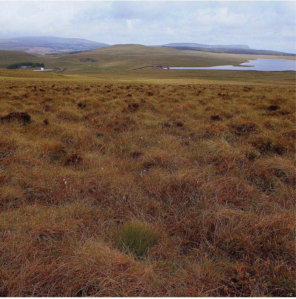
12 Section 2 What is so special about blanket bog? The habitat Peat is a waterlogged soil that is composed of compacted, partially decomposed vegetable matter. Blanket bogs are areas of wet peatland, where peat depth is greater than 50cm. The peatland is fed exclusively by rainwater, with little or no contribution from laterally moving mineral-rich soil waters. They are one of the most extensive semi-natural habitats in Ireland. 10

13 Most blanket bogs began to form between 5,000 and 6,000 years ago, though some may have begun as much as 9,000, or as recently as 1,500 years ago. Before then, much of Ireland was clothed in native trees such as oak and hazel. It is likely that blanket bogs were formed due to a combination of native forest clearances and a wetter climate resulting in increased water logging and leaching of soils. This encouraged bog mosses to develop. The removal of trees would have further increased water logging, making the area less suitable for trees, and further encouraging the bog mosses. The increasing dominance of bog mosses and the resultant high water content of the soil would have reduced ph, slowed decomposition of organic matter, and encouraged peat to form. Blanket bogs are defined as a peatland that is not confined by the surrounding topography. The conditions required for its formation allows blanket bog to develop across the landscape, rather than be limited to individual depressions or catchments. It is from this blanketing of the landscape that the habitat derives its name. Blanket bog that supports significant areas of peat-forming plants is referred to as active blanket bog, a priority habitat under the EU Habitats Directive. An active blanket bog on average increases the peat depth by 0.5-1mm per annum over deep peat and is dependent on a layer of peat forming vegetation and a high water table. In most peat bogs, Sphagnum (moss) is responsible for laying down the majority of the accumulated peat. Large areas of blanket bog and deep peat soils persist despite not actively forming peat, something that may have a significant bearing on their conservation management or restoration. The Landscape Blanket bog is found in areas with a high rainfall and cool climate, climatic conditions required for its formation. As a result it has a limited global distribution. In Europe, blanket bogs are found primarily in Ireland and the UK. This is one of the habitats found on the moorlands that are distributed across the uplands. These moorlands are a significant part of our cultural heritage. They can be important places for archaeological material where people have lived and worked for thousands of years. This continues today as the uplands are primarily used for agriculture especially grazing sheep and for sporting management such as shooting and for other recreational activities like walking and mountain biking. Natural bogs consist of a protective living surface layer of soft conductive peat which is aerobic. This layer covers a layer of denser anaerobic peat. Many peatbogs have lost their protective surface layer. When bogs lose their surface layer, the carbon store is at risk and may be steadily lost. The plants in the surface layer capture CO 2 from the atmosphere into their tissues, and carbon passes to be stored in the denser anaerobic peat as plants die. The water table in intact peatlands fluctuates a little, but is usually close to the surface. The capacity to store significant additional water is therefore low and rain runs off intact peatlands quickly. However, the creation of drainage channels accelerates the rate at which water leaves a peatland. This means that in the process of restoring a peatland that contains drains a lot of water is retained 11

14 and stored. Blocking drains is likely to lead to a longer water retention time and therefore slower run off rates. Run off is also accelerated by the loss of vegetation which leads to increased areas of bare peat caused by overgrazing, a widespread problem in many blanket bog areas of Northern Ireland, and desiccation in damaged peatland. This can lead to peat becoming so dry that water will no longer infiltrate and so runs off the surface quickly into streams and rivers, potentially exacerbating flooding downstream. Conversely, in areas where grazing levels are suitable for blanket bog vegetation to provide adequate cover, flow peaks can be reduced and slightly delayed compared to bare peat. Water derived from functioning peatlands is naturally of very high quality. However the amount of dissolved organic carbon (DOC), the brown colour of peaty water, has doubled across many catchments due to erosion often caused by overgrazing and by drainage. To meet drinking water quality standards set out in the European Drinking Water Directive, DOC has to be removed from drinking water supplies, as otherwise chlorination during water treatment results in the production of carcinogens. Removing DOC can be extremely costly, especially if new treatment processes need to be added. Erosion also reduces water quality for fish, affecting for example rivers used for angling downstream. water table remains within -10cm of ground level all year round. Drainage results in the death of the Sphagnum and the peat bog loses its ability to capture and store carbon and remain active. Sphagnum is the life blood of a peatland because the bog simply can not function and grow without it. The peatland that is created by Sphagnum is a priority for conservation in Northern Ireland. Marsh saxifrage Marsh saxifrage Saxifraga hirculus is an attractive, yellow-flowered perennial that requires base-rich and wet conditions. It is now an upland species because its favoured wetland habitats in the lowlands have been destroyed. It has suffered from overgrazing and drainage, although moderate levels of grazing are probably beneficial to this plant. Marsh saxifrage is found only on the Garron Plateau and nowhere else in Northern Ireland. They are a priority for conservation in Northern Ireland. The wildlife Sphagnum Compared to vascular plant species Sphagna are slow to decay. As a result Sphagnum (moss) is responsible for laying down the majority of the accumulated peat in bogs. It survives where the 12 Marsh saxifrage

15 Viviparous lizard Viviparous lizard Viviparous (or common) lizard is the only species of reptile that is native to Ireland. The typical adult size is approximately 15cm (nose to tail). Females give birth to inchlong lizards in August after incubating the eggs in little pouches. They like open sunny places such as exposed rocks and mats of vegetation like cotton grass and sphagnum where they can bathe in the sunshine. Peatland such as that found on the Garron Plateau is a favoured habitat. They are a priority for conservation in Northern Ireland. Hen harrier Hen harrier The male hen harrier is a pale grey colour, while the females and immature birds are brown with a white rump and a long, barred tail. In the breeding season birds are found on the upland heather moorlands. Here they search for food, which mainly consists of meadow pipits and skylarks, and nest among long heather and other vegetation. During the winter, birds disperse over upland areas, as well as to coastal and lowland wetland habitats, and use communal winter roost sites. They are a priority for conservation in Northern Ireland. Golden plover The golden plover breeds in small numbers on a few upland moorland sites in Northern Ireland. The Garron Plateau is one such site where they settle on remote and exposed hilltops in spring and summer. In winter they leave the uplands to form large flocks with other golden plovers that come from northern Europe. They generally spend the 13 Golden plover

16 winter around lowland wetland and coastal areas, often in the company of lapwings and other wading birds, but small groups are also seen in upland areas. They are a priority for conservation in Northern Ireland. Red grouse The red grouse is a medium-sized game bird that breeds in the upland heather moorland. They are usually seen when flushed from heather, rising quickly to fly off calling loudly before settling again some distance away. Unlike many of the other birds that share this landscape, red grouse remain here all year round. In fact they do not travel far in their lives, preferring to stay close to the area where they were born. Their population is dangerously low and they require large landscapes to survive. Populations that survive in small isolated areas are unlikely to be enlarged by recruits from other areas due to their sedentary nature. They are a priority for conservation in Northern Ireland. Snipe Snipe Snipe are medium sized wading birds with short legs and long straight bills. They breed on the uplands and on the lowland wetlands in Northern Ireland. In spring the male makes a drumming sound with its tail feathers while flying in circles above its breeding site. It builds a nest on the ground in a tussock of grasses, sedges, rushes or heather. Winter birds arrive from northern Europe to join resident birds. The population of breeding snipe has undergone declines across Northern Ireland. Curlew Red grouse The curlew is a large wading bird, well known for its very long, decurved bill and its haunting call and bubbling song. Curlews have declined as a breeding species in Northern Ireland and elsewhere in northern Europe over the last twenty years. They nest on the ground by concealing a nest in long grass. Winter birds arrive from north and eastern Europe to winter around the coast, and on inland wetlands such as Lough Beg. They are a priority for conservation in Northern Ireland. Curlew 14

17 Section 3 Threats to blanket bog Northern Ireland has approximately 140,000 ha of blanket bog. Pressures on blanket bog can lead to extensive peat erosion. Some of the major threats to blanket bog in Northern Ireland include: Grazing levels - Overgrazing is the biggest issue facing blanket bog on the Garron Plateau and most other upland peatland sites in Northern Ireland. Overgrazing reduces the amount of vegetation cover that exists on peatland and leads to large areas of bare peat. In many cases this goes on to cause peat erosion. Overgrazing can alter the height of heather significantly, and in many cases can lead to the loss of this and other important blanket bog plants from the peatland altogether. Historically, the conversion of blanket bog to pasture through drainage, ploughing, reseeding with a rye grass mixture, liming and fertiliser application has resulted in direct losses of habitat. Today, agricultural improvement is controlled by national and international wildlife designations (such as ASSIs), by the Environmental Impact Assessment (Agriculture) Regulations (Northern Ireland) 2007 and by practicing good agricultural and environmental condition (GAEC) as part of receiving public funds in the form of the single farm payment (SFP). Forestry - Conifer plantations have been a major cause of direct loss of blanket bog and wet heath habitat in Northern Ireland. Preparation for afforestation involves draining followed by ploughing or mounding. Drainage for forestry can have a negative impact for 15

18
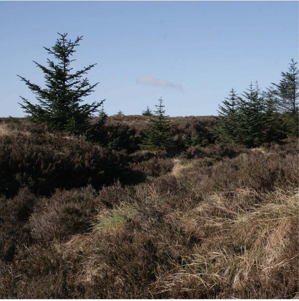
19 Forestry bordering the Garron Plateau ASSI a considerable distance into adjacent peatland habitats. As trees grow they draw more water, and high evaporation rates from their leaves lowers the water table further. Forestry plantations require fertilisation, pest control and often liming to make the soil less acidic, and trees intercept airborne pollutants and incorporate them into the soil water. These all directly affect water quality and biodiversity. The effects of pesticides and additional nutrients is damaging as the bog ecosystem is naturally poor in nutrients and comprises sensitive species that have adapted to extreme conditions. Self-seeded conifers such as Sitka spruce have become established on bogs adjacent to forestry across uplands in Northern Ireland where they detract from the naturalness of the bog vegetation. Plantations also provide cover for predators such as fox and hooded crow, introducing a significant predation pressure on ground nesting birds. Peat cutting and peat extraction - Both domestic peat cutting and commercial extraction of peat can have significant detrimental impacts upon peat bogs and can damage archaeological sites. Organic carbon stored within the blanket peat, which has accumulated over thousands of years, can be lost in days due to extraction. Bogs are drained to facilitate extraction, adding to the degradation of the habitat. The situation is much worse for commercial peat cutting and peat extraction using machinery over a large area, compared to smallscale domestic peat cutting by hand. Burning - Inappropriate burning can result in the loss of key plant species, the breakdown of the peat structure, or increased erosion. In the worst cases, re-vegetation of bare peat is prevented by grazing and frequent burning can make the vegetation less diverse. Damage can be irreversible when this is combined with overgrazing and/or drainage. Burning is not permitted on blanket bogs in Northern Ireland for this reason. Drainage - Drains intercept and divert overland flow to remove water rapidly from the peatland system. All drains affect the water table, causing changes in vegetation. Peat formation on blanket bog is dependent upon the existence of Sphagnum (moss) which occurs where the peat is sufficiently waterlogged. Drains are therefore a major threat to the ability of a blanket bog to remain active. Drains accelerate the rate at which water leaves a peatland, increasing flood risk downstream, and contributing to erosion which can increase DOC - the amount of dissolved organic carbon which causes the brown colour in peaty water). Development - A wide range of developments and their associated infrastructure may result in direct or indirect loss of blanket bog habitat. These developments may include communication masts, wind farms, hydroelectric schemes and roads. 17

20 Encroachment by rhododendron and Sitka spruce - The spread of Rhododendron ponticum and Piceasitchensis (two non-native and invasive plant species) from forestry plantations, areas managed for game birds and from gardens results in a change to the species composition, habitat structure, and hydrology. It is well known that rhododendrons affect soil and light so that nothing grows beneath them. Climate Change - Drier summers and stormier winters, predicted as a consequence of global climate change, may have a profound impact on blanket bogs through a lowering of the water table, drying of peat, and loss of peat forming plant species such as Sphagnum. Phytophthora species - Phytophthora ramorum is a fungus-like pathogens of plants that are causing extensive damage and mortality to trees and other plants, such as rhododendron and bilberry, in parts of Britain and Ireland. This situation is developing and the spread of these pathogens could have a detrimental impact on blanket bog plant species. Recreation Walkers on popular walking routes or people using allterrain vehicles can result in localised habitat loss through trampling and erosion. 18

21 Section 4 Project Area Crown Copyright. RSPB License Number KEY: Lough Neagh and Lough Erne basin Blanket bog Project area on NI Water land on the Garron Plateau Garron Plateau ASSI/SAC The RSPB/NIEA Rebuilding the Countryside project in Northern Ireland prioritised the Garron Plateau ASSI/SAC/SPA. At 4,628ha the Garron Plateau contains the most extensive area of intact upland blanket bog in Northern Ireland. The peatland complex is composed of active blanket bog, transitional mire and calcarous fen. The vegetation includes a mixture of cross-leaved heath Erica tetralix, deergrass Trichophorum cespitosum and hare s-tail cottongrass Eriophorum vaginatum, with a generally high cover of dwarf-shrubs and Sphagnum papillosum, S. fuscum and S. imbricatum. It is the main Irish location for both few-flowered sedge Carex pauciflora and tall bog-sedge C. magellanica. The site contains the only Northern Ireland population of the Annex II species Marsh saxifrage Saxifraga hirculus. The area is designated a SPA for hen harrier and merlin. 19
22
23 The area is situated on the edge of the Lough Neagh basin and plays a part in the overall hydrological function of the landscape from upland to lowland. Northern Ireland Water own the central area around Dungonnell Reservoir and local farming families own or have grazing rights in parts of the Garron Plateau. Forest Service owns the adjacent land at Glenariff and Longmore. The Dungonnell Reservoir and its catchment area provides drinking water to the population of the rural area of North Antrim, including the Glens area, Cushendall, Cushendun, Waterfoot, Cargan, Newtowncrumlin, Clogh, Cullybackey, Portglenone, Ahoghill, Rathkenny, Johnstonstown, and Ballymena. This highlights the public services and goods that are provided by such a landscape. Northern Ireland Water, in partnership with the RSPB, Northern Ireland Environment Agency and others, are implementing a Sustainable Catchment Management Plan (SCaMP) across the landscape that surrounds Dungonnell Reservoir. The aim of this plan includes restoring the vegetation cover to prevent bare peat from forming across the landscape surrounding the reservoir. SCaMP does this by ensuring that appropriate grazing levels exist to allow vegetation to cover the entire peatland, and by blocking drains that would otherwise carry bare peat directly into the reservoir. It is expensive to take the dark brown colour caused by dissolved organic carbon (DOC) out of the water and make it clear for drinking. To ensure that the reservoir water is managed sustainably, the surrounding landscape must be free from bare peat in drains and across grazing areas so that any water running off the landscape is of clean quality to treat efficiently. 21
24
25 Section 5 Project Objectives One of the main objectives of this project is to restore the Garron Plateau ASSI to favourable ecological condition as required by the NIEA under 38(2) of the Environment (Northern Ireland) Order Another main objective is to implement a Sustainable Catchment Management Plan (SCaMP) on the Garron Plateau and to demonstrate the cost effectiveness of this approach by highlighting the function played by good quality peatlands in the provision of drinking water. Developing a management plan helps identify and mitigate all of the threats that face the blanket bog and associated habitats, and implement measures to restore and sustainably manage the area. The project will demonstrate how appropriate grazing levels can provide sustainable land management in an area that provides services such as food and water. Drain blocking will also be demonstrated (where required). This demonstration and advocacy work will help to inform key people such as farmers, land managers and policy makers who are in a position to carry out similar work in other blanket bog areas of Northern Ireland. Ensuring appropriate grazing levels on blanket bog to prevent issues such as peat erosion Blocking drains within the Dungonnell catchment area (where required) to prevent peat erosion, improve raw water quality and restore hydrology Demonstration and advocacy work to encourage and support landscape-scale blanket bog restoration/management in other areas Information sharing with similar projects in Northern Ireland
26 Section 6 Restoring active blanket bog Thankfully in most situations where blanket bogs have been damaged through overgrazing and other activities such as drainage, restoration is a realistic option. The best results for regaining blanket bog biodiversity will occur where appropriate grazing levels can be achieved (0.075LU/ha) on sites that have suffered from overgrazing, and where natural hydrology can be restored when drainage has taken place. To fully restore an area of blanket bog it is necessary to look at all the issues affecting the site, principally grazing, hydrology, and burning. On the Garron Plateau, grazing is the main issue. This is similar to most blanket bog areas in Northern Ireland. Hydrology is affected on only parts of the site where drains have been cut through the peat for agricultural and forestry operations. Burning does not take place. Key management interventions to restore blanket bog habitat in all parts of Northern Ireland, should have two main aims: to provide appropriate grazing levels to encourage the growth of native plant species, protect the underlying peat from erosion, and discourage non-native species; to raise the water table to allow the native blanket bog plant species to thrive and continue forming peat. Grazing Overgrazing is one of the main causes of peat erosion on blanket bog in Northern Ireland. While it is important to graze these areas to provide food, it is also important to ensure that grazing is kept within a sustainable level. This will achieve adequate vegetation cover to 24
27 prevent bare peat and peat erosion. Adequate blanket bog vegetation cover will also ensure that peat continues to form on the bog, providing a store for water and carbon. Blanket bogs should be grazed by sheep only. The grazing level should not exceed 0.075LU/ha (1 Livestock Unit is equivalent to :- 6.6 sheep - all ages). Blanket bog should be grazed from 1st March - 31st October only. There should be no grazing from 1st November 28/29th February. The key for active bog is the presence of a Sphagnum layer, which is relatively fragile and reacts to over grazing/trampling pressure. In some instances there will be a need to have no grazing at all on blanket bog to allow vegetation to recover after overgrazing has occurred. There might be circumstances where an intact functioning blanket bog with pools and/or extensive Sphagnum will have its structure maintained by the hydrology. In this situation grazing may not provide anything from an ecological perspective. Therefore while grazing takes place on blanket bog as a farming activity it may not be required on some intact, undamaged bogs. Recommended stocking densities and grazing periods for other peatland types may vary. Where a mix of peatland types such as dry heath, wet heath and blanket bog (at least 20% of each type) occur within the same grazing unit, an average stocking density, based on the ratio of different types, may be applied to the whole unit. The precautionary measure for peatland sites that are principally made up of blanket bog is to reduce grazing levels to the recommended 0.075LU/ha. Blanket bog typically grades into wet and dry heath on many sites. For wet and dry heath, recommended grazing levels range between 0.20LU/ha and 0.30LU/ha respectively. However, any increase in grazing pressure in the direction of these levels should only be instated on a case by case basis after a period of vegetation monitoring has shown the need for such an approach. On the area around Dungonnell Reservoir, Garron Plateau, it is expected that the 0.075LU/ha grazing level will be appropriate. It is not anticipated that any changes will be made to that level in the short term. The vegetation response will be monitored and small adjustments may be made as a result in the medium to longer term. Drainage Another cause of peat erosion on blanket bog is the existence of drains that have been cut through bogs. Where drainage has occurred across upland landscapes in Northern Ireland, this has resulted in significant changes to the hydrology. Drains that intended to improve the uplands for agriculture did not on their own lead to an increase in the growth of vegetation suitable for sheep and have had many negative impacts including the following: An increase in the colour of water leaving peatland leading to impacts on drinking water and associated health issues, as well as significant costs to the water companies in purifying the water for drinking. Loss of lambs and sheep, which fall into the deep, eroded drains and cannot escape. 25
28 A decrease in the diversity of characteristic plant species associated with a variety of wet soil conditions. Possible localised flash flooding caused by greatly increased speed of run-off (an example of this includes the impact from drains in blanket bog on Cuilcagh Mountain in Fermanagh in the 1990s when the Marble Arch Caves experienced flooding up until Fermanagh District Council and the RSPB worked in partnership and blocked drains as part of a blanket bog restoration project). An increase in erosion and destruction of the peat body resulting in the silting up of streams. The blocking of drains in peatland has become a recognised management technique to re-wet the habitat by restoring natural drainage patterns and, through long term regeneration of the blanket bog, reverse the negative effects of drainage. Within the catchment area of Dungonnell Reservoir on the Garron Plateau, drainage is restricted to two main areas, where up to 16450m (16.4km) of drains have been mapped for attention. Drain blocking methods Across Ireland and the UK, a variety of methods and materials have been used for drain blocking. All the techniques create dams or block the entire drain in order to hold back the water and encourage silting-up with peat. The drains can then become rapidly colonised by Sphagnum moss and other plant species. There are four main methods that can be used to block drains where this is required: heather bale dams; peat dams; re-profiling; and plastic curtain. Each of these methods has its advantages and disadvantages depending on the site, catchment and peat conditions. For each drain, the method of blocking may be influenced by: slope, orientation relative to slope and catchment, up-slope catchment area, size of drain, amount of water the drain currently carries, peat depth, and the possible existence of peat-pipes (underground channels that carry water through the bog). Most drain blocking is carried out using peat dams. This method is the cheapest and works very well in most conditions, but all four methods are outlined below, along with other drain management considerations. Peat dams In most areas, in particular those with little or no heather (or where it is advisable not to flail heather), peatonly dams can be used. The technique involves removing short strips of vegetation from either side of the 26
29 drain. The underlying peat is then worked and raised to create the dam and is sloped to prevent stock becoming trapped. The vegetation is then placed on top of the dam to reduce the amount of bare peat. Re-profiling Deep drains with steep sides can also be reprofiled between dams by dropping the sides. The vegetation is peeled back between dams, then the underlying peat is worked to produce a shallower gradient, approaching 45 degrees, and the vegetation is put back on top. This will reduce the risk to sheep and red grouse falling in, slow the water down and act as a sediment trap that will increase the ability of the dams to raise the water table. Short, shallow channels may need to be cut into the sides of the drain, upstream of the dam. These will reduce the pressure on dams within a large drain and allow water to escape out of the confines of the channel onto the wider peat body. On shallow slopes and areas where the drain contours the slope, these channels may not be required as water will naturally overflow away from the drain. Plastic curtain If water is found to be seeping laterally out of the site through the peat, the lateral seepage can be reduced by installing a plastic curtain. This is a sheet of plastic that will insert vertically into the ground to prevent lateral water movement, but will only be successful where there are impermeable/slowly impermeable soils within 2m of the bog surface. To establish if this impermeable soil exists, take cores from the area under consideration. Heather bale dams The use of heather is only possible where there are large areas of dry heath adjacent to blanket bog where heather can be cut and baled. Where water has been running through a drain the bottom will have been rounded out. Short (2 metre) sections of the drain must be reprofiled to allow heather bales to be placed on the bottom to fit tightly and block water. A layer of peat, 27
30 taken from upstream of the dam, is placed on top and on the upstream side of the heather bale with a sloping face. Vegetation is then placed on top of the dam to prevent the exposure and erosion of bare peat. A short drainage channel can be created to move overflowing water away from the drain. The sides of the drain behind the dam should be pushed-in slightly for stock safety. For drains on a significant slope or on shallow peat, the drain may need to be fully blocked. This is where lengths of drain can be in-filled with heather bales to act as sediment traps between peat dams. It is important the machine operator has a good understanding of the objectives. Whatever method is used, it is important that there is permanent water between each dam and that bare peat is kept to an absolute minimum. Other drain management considerations Practical work should only take place outside the bird breeding and lambing seasons to minimise disturbance and only specialist machinery and competent contractors should be used. Use of machinery should minimise the amount of compaction and rutting of the peat, which would further increase run-off. Contractors should avoid driving up and down the slopes to reduce rutting that may develop into drainage channels. When creating the dams, whichever method is used, it is important to know how deep the peat is beneath the base of the drain. This is necessary to reduce the amount of mineral soil found within the dam, which can cause it to fail. A thin layer of clay is often found under the peat. It is vitally important that this layer remains intact. On steep slopes, it is important that pools behind the dam are kept to a minimum. This reduces the possibility that the pooled water will flow directly around the dam and back into the drain. Installing dams on slopes with shallow peat at the base of the drain may not hold back water as the seal with the underlying soil is unlikely to be water tight. Complete infilling of drains will be necessary on certain drains either by re-profiling or using heather bales, as dams may not be sufficient on their own. Techniques will continue to evolve but at the time of writing, large areas of suitable drains are blocked using re-profiling in association with peat dams. Afforested blanket bog Large areas of the uplands were once regarded as being unproductive for agriculture. During the post war period, Government bought large tracts of this land to plant them with Sitka spruce (a non-native conifer species). To create a suitable growing medium for these trees, the blanket bog was heavily drained and fertilisers were added to improve growth performance. In many cases, the land was not suitable for forestry, and resulted in a very poor timber crop. Infrastructure, especially roads, needed 28
31 for commercial forestry has also caused damage to blanket bogs. Many of the areas of upland that are currently forested have been identified by a Forest Service woodland creation map as unsuitable for woodland creation. Removal of non-native species In some upland moorland areas, non-native plants have become a significant problem to the ecology of blanket bog. Conifer seedlings (mainly sitka spruce) and rhododendron have spread out onto the open moors from neighbouring land. Where there is sufficient grazing pressure, seedlings growing on the open moors are unlikely to survive beyond their first couple of years. Sitka spruce can be cut down below the bottom whirl using handsaws or chainsaws, or hand pulled then inserted into nearby drains to assist with the drain blocking work (if required) by acting as sediment traps. Where rhododendron plants exist they can be removed from the site either by cutting, winching or digging to ensure all of the roots are removed. They must be taken off site (especially a designated site such as an ASSI or SAC) and burnt. All plants should be checked for the presence of Phytophthora spp. before being removed. The DARD website can be checked for updates: 29
32 Section 7 Budgets A key success of taking a landscape-scale approach to restoring peatlands is the value for public money that it achieves. Pooling resources from voluntary and statutory bodies allows us to access additional funding, for delivery of both government and EU priority. The outcomes delivered by such an approach can be significantly greater than the contribution any individual partner could achieve acting alone. This is particularly pertinent where partnership working can help to deliver on statutory responsibilities on land owned or managed by government partners to several times the value contributed by the public purse. For example, a management plan for the Dungonnell catchment area on the Garron Plateau has been produced through funding from NIEA and the RSPB. Implementation of the plan will be funded by Northern Ireland Water through the Sustainable Catchment Management Programme in Northern Ireland (SCaMP NI), and by DARD Countryside Management Unit through the Northern Ireland Countryside Management Scheme (NICMS). By working in partnership it is possible to pool funding streams and make best use of existing resources to deliver peatland restoration on a much wider scale across similar landscapes in Northern Ireland. Grazing rates are the most important issue to get right on blanket bog. Farmers with blanket bog on their land can join the Northern Ireland Countryside Scheme and receive payment to restrict grazing rates to LU/Ha. Where drainage is an issue, peat dams can cost an estimated per metre and heather bale dams cost an estimated 5.50 per metre. Re-profiling costs an estimated 1 per metre. The costs for removing self seeding trees from blanket bog varies dramatically depending on the density and age of the trees. In areas where chainsaws are required to remove the majority of the trees, and the density is around 0.5 tree/m 2, the estimated costs would reach 1,000/ha. Within the Common Agricultural Policy (CAP) there is a need to improve funds to better reflect ecosystem service benefits and contribute to wider government objectives for biodiversity, water and carbon. CAP could: Ensure an appropriate range of payments across peatland management activities at the right level of payment to incentivise initial and ongoing management Explore opportunities to integrate private / public initiatives to fund payment for ecosystem services as a means of helping ensure payments reflect the costs to a land manager of peatland restoration and management Promote whole farm conservation and management encompassing payment for maintaining and restoring peatlands. A coordinated approach to support collaborative payment applications for peatland management at a landscape-scale across multiple land holdings Improve monitoring of environmental objectives under the payment schemes to allow proper assessment of effectiveness and progress 30
33 Section 8 Raising Awareness Blanket bog and heather moorland is a familiar part of the upland landscape of Northern Ireland, but the blanket bog habitat as part of this is not easily recognised by the public. Its importance locally and globally is not widely understood. Without the backing and support of local communities, landscape restoration projects would not be completely successful. The Garron Plateau offers the opportunity to raise awareness and understanding of the blanket bog habitat in Northern Ireland. As a demonstration site, the area around Dungonnell Reservoir will help to inform visitors by highlighting the important service that blanket bog plays in the supply of drinking water. It also helps inform land managers about some of the management techniques, especially grazing levels, that can be used to restore and manage blanket bog in Northern Ireland. 31
34 Section 9 Working with the Farming Community Practical upland restoration work is reliant on landowners and managers to carry out works. Projects on sites such as the Garron Plateau will provide an opportunity to see some restoration and management work being carried out, and to find out more about how and why a similar landscape-scale approach can be applied to upland management elsewhere in Northern Ireland. 32
35 Sheep numbers have historically been high on blanket bog and in many cases have exceeded a sustainable level. This has led to widespread overgrazing which has caused blanket bog vegetation to decline and in some cases disappear entirely. As a result, large areas of exposed bare peat have appeared and because the vegetation cover is not adequate enough to stabilise soils, erosion has taken place as rain water washes the peat into drains, rivers and reservoirs. The farming community can and should be supported to practice sustainable grazing on blanket bog, using support from the Northern Ireland Countryside Management Scheme run by DARD, and where available, the Sustainable Catchment Management Programme that is run by Northern Ireland Water. 33
36 Where drainage occurred on the uplands of Northern Ireland, one of the initial aims would have been to increase livestock production. However, there is little evidence that a drained peatland can sustain the large increases in stock that usually follow the drainage operations. Where drains exist, and can be blocked, restoration can help increase sheep use, probably because dams provide a greater number of drain crossing points. Research has shown that drain blocking does not lead to any changes in grass abundance. In contrast, sedges increase and dwarf shrubs decrease marginally in areas directly adjacent to blocked drains. Therefore drain blocking is unlikely to alter the availability of grazing, but may increase stock access to wetter areas. Domestic peat cutting and commercial peat extraction each have significant detrimental impacts upon blanket bogs. Organic carbon stored within the blanket peat, which has accumulated over thousands of years, can be lost in days due to these activities. Bogs are drained to facilitate peat cutting and extraction, adding to the degradation of the habitat. Bare peat develops and causes erosion and issues with water quality. The situation is much worse for commercial peat cutting and peat extraction using machinery over a large area, compared to small-scale domestic peat cutting by hand. Agri environment schemes and sustainable catchment management programmes should support farmers and land managers to retain blanket bogs as carbon and water stores within the landscape. 34
37 Forestry and farming in the future To ensure that blanket bog habitat is protected and, where possible restored, it is important to understand that each site will be subject to different pressures. Agri-environment schemes such as the Northern Ireland Countryside Management Scheme have become an effective tool to encourage farmers to carry out practical restoration work on habitats. They have been especially effective at reducing grazing levels to a sustainable level on some blanket bog areas, though they appear to be limited in what they can achieve on land that is common grazing. Special Environmental Projects have been a feature of the Northern Ireland Countryside Management Scheme. This could facilitate the large-scale restoration of blanket bog by ensuring that a number of farmers within the hydrological unit of the bog are signed up to the scheme. It gives each farmer an extra incentive to work in partnership with neighbouring farmers and therefore could also help restore and manage areas of blanket bog that is common grazing. Northern Ireland Water is working with a range of partners to deliver Sustainable Catchment Management Planning for Northern Ireland (SCaMP NI). Future opportunities may include catchment scale management around reservoirs on private farms where capital works are not subject to existing financial support through agri environment agreements or other land management initiatives. Upland farming in Northern Ireland is part of the rural economy. To retain these vitally important habitats, land users and relevant organisations need to work with farmers to ensure the maintenance and enhancement of active blanket bog. The following principles should guide future management of upland habitats in Northern Ireland: 35
38 Appropriate sheep grazing levels (0.075 LU/ha) should be used to maintain and enhance typical blanket bog vegetation (cattle grazing should only ever be used on suitable areas of upland mosaic). Blanket bog should be grazed from 1st March-31st October only. There should be no grazing from 1st November-28/29th February. New drains should not be dug on any blanket bog. Wherever possible, all suitable drains should be blocked. Existing drains should not be cleared of vegetation and silt. Trees should not be planted on deep peat. Conifer plantations and self-seeding non-native species should be removed from all upland sites. Any new conifer plantations or replanting of conifers should contain a native broadleaf buffer zone to protect areas of blanket bog from encroachment by non-native species. Forestry plantations neighbouring ASSIs/SACs should implement a strategy to prevent seeding into the site, which should include covering the costs of clearing any plants that do invade ASSIs/SACs. Rhododendron and larch on all adjacent areas should be removed to protect upland vegetation from invasion and the spread of Phytophthora spp. No fires should be lit on or close to areas of deep peat, or typical blanket bog vegetation. No new infrastructure should be allowed on active blanket bog or deep peat (e.g. tracks or windfarms). 36
1 Introduction. 1.1 Key objective. 1.2 Why the South Esk
 1 Introduction 1.1 Key objective The aim of this study is to identify and assess possible options for improving the quality of the river channel and habitats in the River South Esk catchment whilst helping
The Roaches Asset Management Review. Draft Objectives for External Consultation. Fundamental Principles
 The Roaches Asset Management Review Draft Objectives for External Consultation Fundamental Principles the area of land under review is the Roaches Estate and Gradbach Car Park as shown on the attached
Using the voluntary carbon market to provide funding for natural capital projects in the UK. 6 th October 2015
 Using the voluntary carbon market to provide funding for natural capital projects in the UK 6 th October 2015 The problem we face Natural Capital Stock of natural ecosystems that provides a flow of goods
Waterway Technote Drains
 Waterway Technote Drains Contents Benefits of good drain practice 1 Are your drains healthy? 2 The Sustainable Dairying Water Accord 3 Planning drain maintenance 3 Fencing and clearing 3 Bank shaping (battering)
CATCHMENT MANAGEMENT USING PAYMENTS FOR ECOSYSTEM SERVICES TO RESTORE AND MAINTAIN UPLAND PEAT
 CATCHMENT MANAGEMENT USING PAYMENTS FOR ECOSYSTEM SERVICES TO RESTORE AND MAINTAIN UPLAND PEAT There is growing interest in the potential for Payments for Ecosystem Services (PES) to fund conservation
Post-Wildfire Clean-Up and Response in Houston Toad Habitat Best Management Practices
 Post-Wildfire Clean-Up and Response in Houston Toad Habitat Best Management Practices Purpose The purpose of this document is to provide guidance and recommendations for minimizing potential impacts to
How To Plan A Buffer Zone
 Backyard Buffers Protecting Habitat and Water Quality What is a buffer? A buffer (also called a riparian buffer area or zone) is the strip of natural vegetation along the bank of a stream, lake or other
From Evidence to Action: Whole-catchment approaches to linking flood risk management and WFD measures
 From Evidence to Action: Whole-catchment approaches to linking flood risk management and WFD measures Nick Hardiman Royal Society for the Protection of Birds A wealth of research has been devoted to the
Ecosystem services in grasslands: evidence, trade-offs and restoration. James Bullock NERC Centre for Ecology and Hydrology jmbul@ceh.ac.
 Ecosystem services in grasslands: evidence, trade-offs and restoration James Bullock NERC Centre for Ecology and Hydrology jmbul@ceh.ac.uk Ecosystem services definitions and types Grasslands 13% of Earth
SUSTAINABLE URBAN DRAINAGE SYSTEMS
 overflow can lead into a permeable conveyance system to increase further the benefit and reduce the need for pipe systems. Pollutant removal rates have been shown to be high, with some pollutants being
Improving the physical condition of Scotland s water environment. A supplementary plan for the river basin management plans
 Improving the physical condition of Scotland s water environment A supplementary plan for the river basin management plans Contents Executive summary... 2 1. Introduction... 3 2. Vision... 4 3. Taking
Appendix C. Re-vegetation and Rehabilitation Sub-Plan
 Appendix C Re-vegetation and Rehabilitation Sub-Plan DRENNAN SOLAR ENERGY FACILITY REVEGETATION & REHABILITATION PLAN PRODUCED FOR ERM ON BEHALF OF SOLAIREDIRECT BY Simon.Todd@3foxes.co.za JUNE 2013 BACKGROUND
WONDERFUL, WATERFUL WETLANDS
 WONDERFUL, WATERFUL WETLANDS OBJECTIVES The student will do the following: 1. List characteristics of wetlands. SUBJECTS: Science, Language Arts TIME: 60 minutes 2. Describe the functions of a wetland.
Rural Flooding: The Potential Role of Forestry
 Rural Flooding: The Potential Role of Forestry Nadeem Shah, Tom Nisbet, & Huw Thomas Centre for Forestry and Climate Change Structure Background Woodland and Flood Alleviation The Theory. Studies on Woodland
RESTORATION & REVITALIZATION
 RESTORATION & REVITALIZATION Legal preservation has not proved to be sufficient to preserve natural communities. Restoration activities are diverse and includes revitalization of natural communities which
Policy & Management Applications of Blue Carbon. fact SHEET
 Policy & Management Applications of Blue Carbon fact SHEET Policy & Management Applications of Blue Carbon Coastal Blue Carbon - An Important Wetland Ecosystem Service Coastal Blue Carbon refers to the
River Wensum Restoration Strategy Swanton Morley Restoration Scheme Reach 14a
 River Wensum Restoration Strategy Swanton Morley Restoration Scheme Reach 14a At a glance River restoration benefits: Improved planform, channel cross-section, flow variation and sediment process. Improved
Outlet stabilization structure
 Overview of Sedimentation and Erosion Control Practices Practice no. 6.41 Outlet stabilization structure Erosion at the outlet of channels, culverts, and other structures is common, and can cause structural
PROCEDURE. See: Great Lakes Coastal Wetlands (http:// www.miseagrant.umich.edu/wetlands/index.html)
") Activity: Students review a selection of career profiles and play a lively classroom game to find out more about marine and aquatic science professionals. Grade Level: 4-8 Subjects: Science, social studies
Activity: Students review a selection of career profiles and play a lively classroom game to find out more about marine and aquatic science professionals. Grade Level: 4-8 Subjects: Science, social studies
MoorLIFE: Active Blanket Bog Restoration in the South Pennines Moors Monitoring Programme Mid-Term Report. November 2013
 MoorLIFE: Active Blanket Bog Restoration in the South Pennines Moors Monitoring Programme Mid-Term Report November 2013 1 MoorLIFE:Active Blanket Bog Restoration in the South Pennine Moors. Monitoring
The River Ribble is one of the longest rivers in the North West of England
 River Ribble The River Ribble is one of the longest rivers in the North West of England Did you know? The tidal limit of the Ribble is 11 miles inland (above Preston); The River Ribble is home to a variety
Clifton Bain IUCN UK Peatland Programme
 Clifton Bain IUCN UK Peatland Programme Peatlands have been identified as a priority for action under international agreements. They provide essential services to society, globally, nationally and locally
WILLOCHRA BASIN GROUNDWATER STATUS REPORT 2009-10
 WILLOCHRA BASIN GROUNDWATER STATUS REPORT 2009-10 SUMMARY 2009-10 The Willochra Basin is situated in the southern Flinders Ranges in the Mid-North of South Australia, approximately 50 km east of Port Augusta
Final Report. Dixie Creek Restoration Project. Funded by Plumas Watershed Forum
 Final Report Dixie Creek Restoration Project Funded by Plumas Watershed Forum Plumas Corporation January 2009 1 Background FR-CRM staff presented this project to the Dixie Valley Landowners Association
Flash Flood Science. Chapter 2. What Is in This Chapter? Flash Flood Processes
 Chapter 2 Flash Flood Science A flash flood is generally defined as a rapid onset flood of short duration with a relatively high peak discharge (World Meteorological Organization). The American Meteorological
COMPREHENSIVE PLAN SECTION B, ELEMENT 4 WATER RESOURCES. April 20, 2010 EXHIBIT 1
 COMPREHENSIVE PLAN SECTION B, ELEMENT 4 WATER RESOURCES April 20, 2010 EXHIBIT 1 ELEMENT 4 WATER RESOURCES TABLE OF CONTENTS 4.1 INTRODUCTION 4.2 GOALS AND POLICIES 4.2.A General Goals and Policies 1 4.2.B
Baseline Ecology Survey of Bord na Móna s Bogs Rehabilitation trials and communication
 Baseline Ecology Survey of Bord na Móna s Bogs Rehabilitation trials and communication David Fallon Rehabilitation trials and communication Internal and external communication Rehabilitation trials Drinagh
Mountainous forest watershed management Governance in Greece
 Mountainous forest watershed management Governance in Greece Katerina Koutla Forester Ministry of Environment, Energy and Climate Change Alcala de Henares, 28 29 January 2014 Central Forest Service Ministry
Recognizing Wetlands. For additional information contact your local U.S. Army Corps of Engineers office. Pitcher plant.
 US Army Corps of Engineers For additional information contact your local U.S. Army Corps of Engineers office. 1998 Edition Recognizing Wetlands Pitcher plant The information presented here will help you
A Developer s Guide: Watershed-Wise Development
 A Developer s Guide: Watershed-Wise Development Environmental Protection What is a watershed? It does not matter how far away you build from a creek, lake, or the ocean, you are in a watershed. Another
Waterway Technote Planning
 Waterway Technote Planning Contents Benefits to planning your waterway management 1 Prioritising waterway management where to start? 1 What are your priorities? 1 Start with the best areas or those at
Key Idea 2: Ecosystems
 Key Idea 2: Ecosystems Ecosystems An ecosystem is a living community of plants and animals sharing an environment with non-living elements such as climate and soil. An example of a small scale ecosystem
King Fire Restoration Project, Eldorado National Forest, Placer and El Dorado Counties, Notice of intent to prepare an environmental impact statement.
 This document is scheduled to be published in the Federal Register on 12/24/2014 and available online at http://federalregister.gov/a/2014-30158, and on FDsys.gov [3410-11- P] DEPARTMENT OF AGRICULTURE
HORTOBAGY SODIC LAKES - Restoration of sodic lake sub-type of the Pannonic salt steppe and marsh habitat in the Hortobágy LIFE07 NAT/H/000324
 HORTOBAGY SODIC LAKES - Restoration of sodic lake sub-type of the Pannonic salt steppe and marsh habitat in the Hortobágy LIFE07 NAT/H/000324 Project description Environmental issues Beneficiaries Administrative
How To Preserve Wildlife
 Multiple benefits from catchment restoration Alastair Driver, National Biodiversity Manager Environment Agency, UK @AliDriverEA Biodiversity 2020 the challenge Outcome 1A at least 90% of priority habitats
FORESTED VEGETATION. forests by restoring forests at lower. Prevent invasive plants from establishing after disturbances
 FORESTED VEGETATION Type of strategy Protect General cold adaptation upland and approach subalpine forests by restoring forests at lower Specific adaptation action Thin dry forests to densities low enough
Prepared By: Tom Parker Geum Environmental Consulting, Inc.
 Prepared By: Tom Parker Geum Environmental Consulting, Inc. Topics covered: Definition of riparian and floodplain restoration Floodplain attributes as a basis for developing criteria for restoration designs
Guidelines to Green Roofing
 The Green Roof Organisation (GRO) Excellence in Green Roofs Guidelines to Green Roofing GRO is a partnership of Industry and Stakeholders coming together to develop guidance for specification, design,
Appendix C. Municipal Planning and Site Restoration Considerations
 Appendix C Municipal Planning and Site Restoration Considerations 67 68 Appendix C - Municipal Planning and Site Restoration Considerations This appendix contains best practice standards for site planning
Phosphorus. Phosphorus Lake Whatcom Cooperative Management. www.ecy.wa.gov/programs/wq/nonpoint/phosphorus/phosphorusban.html
 Phosphorus Phosphorus Brochure Lake Whatcom Cooperative Management Reducing Phosphorus Website Washington State Department of Ecology www.ecy.wa.gov/programs/wq/nonpoint/phosphorus/phosphorusban.html Nutrients
Revising the Nantahala and Pisgah Land Management Plan Preliminary Need to Change the Existing Land Management Plan
 Revising the Nantahala and Pisgah Land Management Plan Preliminary Need to Change the Existing Land Management Plan Throughout the Plan 1. There is a fundamental need for the revised plan to address how
GENERAL WATERING & CARE GUIDE
 GENERAL WATERING & CARE GUIDE Between 30-60 percent of water applied to lawns and gardens is never absorbed by the plants. Water is often wasted because it is applied too quickly and runs off, evaporates
4.2 Buena Vista Creek Watershed
 Buena Vista Creek Watershed 4.2 Buena Vista Creek Watershed Watershed Overview The Buena Vista Creek Watershed is the fourth-largest system within the Carlsbad Hydrologic Unit. The watershed extends approximately
Physical Environment. There are economic reasons for countries to cut down their rainforests.
 Tropical Rainforests Reasons for their Destruction Tropical Rainforests are found in the Amazon Basin of South America, (e.g. Brazil) Central Africa (e.g. Congo) and South East Asia (e.g. Indonesia). There
approval of matters specified in conditions; and The Town and Country Planning (Development Management Procedure) (Scotland) Regulations 2013
 (Scotland) Regulations 2013") Application for: planning permission; planning permission in principle; further applications; approval of matters specified in conditions; and mineral workings (if the planning authority do not have a
Application for: planning permission; planning permission in principle; further applications; approval of matters specified in conditions; and mineral workings (if the planning authority do not have a
Biodiversity Concepts
 Biodiversity Concepts WHAT IS BIODIVERSITY? Biodiversity is the variety of life on Earth. For any kind of animal or plant each individual is not exactly the same as any other; nor are species or ecosystems.
Ecological Restoration of a Brackish Marsh at Parcel 11, Estate Carolina, St. John
 Ecological Restoration of a Brackish Marsh at Parcel 11, Estate Carolina, St. John Gary Ray, Ph.D. Virgin Forest Restorations For Coral Bay Community Council Aerial of Parcel 11 Brackish Marsh Ecological
Strategic framework for setting priorities for restoring degraded ecosystems in Germany
 Strategic framework for setting priorities for restoring degraded ecosystems in Germany (EU Biodiversity Strategy, Target 2, Action 6a) Background In the 15 th Aichi Target for the conservation and sustainable
Living & Working Managing Natural Resources and Waste
 Living & Working Managing Natural Resources and Waste 5.13 Managing Natural Resources and Waste Background 5.13.1 This chapter focuses on how we manage resources within the AONB. It includes renewable
Payments for Ecosystem Services: towards improved biodiversity conservation and water security in South Africa, a semi-arid, developing country
 Payments for Ecosystem Services: towards improved biodiversity conservation and water security in South Africa, a semi-arid, developing country Jane Turpie & James Blignaut Introduction Ecosystems largely
Comments on: Middlesex School East Fields Athletics Drainage Calculations Samiotes Consultants, Inc., 16 November 2004
 Comments on: Middlesex School East Fields Athletics Drainage Calculations Samiotes Consultants, Inc., 16 November 2004 submitted to Massachusetts Department of Environmental Protection by William W. Walker,
Water Quality and Water Usage Surveys
 Appendix 1 Water Quality and Water Usage Surveys This appendix contains copies of the Water Quality Survey and the Lake Usage Survey that we used to complete the watershedbased community assessments. We
Farming. In the Standard Grade Geography exam there are three types of farming you need to know about arable, livestock and mixed.
 Types of Farming In the Standard Grade Geography exam there are three types of farming you need to know about arable, livestock and mixed. Arable farms are ones where the main way of making money is by
Colorado Natural Heritage Program
 CNHP s mission is to preserve the natural diversity of life by contributing the essential scientific foundation that leads to lasting conservation of Colorado's biological wealth. Colorado Natural Heritage
Ponds- Planning, Design, Construction
 United States Department of Agriculture Soil Conservation Service Agriculture Handbook Number 590 Ponds- Planning, Design, Construction This handbook describes the requirements for building a pond. It
FOREST RESTORATION MONITORING TOOL
 FOREST RESTORATION MONITORING TOOL Draft version for field test INTRODUCTION FAO upon recommendation of its members identified the need to initiate a comprehensive analysis, evaluation and documentation
Ecosystem Services in the Greater Houston Region. A case study analysis and recommendations for policy initiatives
 Ecosystem Services in the Greater Houston Region A case study analysis and recommendations for policy initiatives Ecosystem Services Ecosystems provide services through their natural processes that we
Wildlifer 2013 Managing Wildlife on Private Lands
 Master Wildlifer 2013 Managing Wildlife on Private Lands Greg Yarrow, Chair and Professor Natural Resources School of Agricultural, Forest, & Environmental Sciences Clemson University Clemson, South Carolina,
Development proposals will require to demonstrate, according to scale, type and location, that they:-
 Appendix 2 : Relevant Development Plan Policies Angus Local Plan Review 2009 Policy S1 : Development Boundaries (a) Within development boundaries proposals for new development on sites not allocated on
Origins and causes of river basin sediment degradation and available remediation and mitigation options. Feedback from the Riskbase workshop
 Origins and causes of river basin sediment degradation and available remediation and mitigation options Feedback from the Riskbase workshop Corinne Merly 1, Olivier Cerdan 1, Laurence Gourcy 1 Emmanuelle
REFERENCE. All National Grid personnel who plan and perform work involving protected water resources are responsible for:
 EG-30NY ENVIRONMENTAL GUIDANCE PAGE 1 of 9 DATE 10/1/10 EP 3 Natural Resource Protection 1.0 SCOPE AND RESPONSIBILITIES National Grid s New York service territory encompasses thousands of wetlands, lakes,
1.7.0 Floodplain Modification Criteria
 1.7.0 Floodplain Modification Criteria 1.7.1 Introduction These guidelines set out standards for evaluating and processing proposed modifications of the 100- year floodplain with the following objectives:
Detention Ponds. Detention Ponds. Detention Ponds. Detention Ponds. Detention Ponds. Detention Ponds. CIVL 1112 Detention Ponds - Part 1 1/12
 CIVL 1112 - Part 1 1/12 The water cycle, also known as the hydrologic cycle, describes the continuous movement of water on, above and below the surface of the Earth. The water cycle, also known as the
Mosquito Control Guidelines
 Appendix G Mosquito Control Guidelines This appendix presents the guidance for designing and maintaining stormwater treatment measures to control mosquitoes from ACCWP s Vector Control Plan. Project sponsors
As stewards of the land, farmers must protect the quality of our environment and conserve the natural resources that sustain it by implementing
 N A T U R A L R E S O U R C E C O N S E R V A T I O N As stewards of the land, farmers must protect the quality of our environment and conserve the natural resources that sustain it by implementing conservation
Water from the Air: Cloud Forests
 Water from the Air: Cloud Forests Alden Wicker Water from the Air: Cloud Forests In the Americas, Asia, and Africa, there s a special kind of forest. It s rare, beautiful, and incredibly important to the
Angora Fire Restoration Activities June 24, 2007. Presented by: Judy Clot Forest Health Enhancement Program
 Angora Fire Restoration Activities June 24, 2007 Presented by: Judy Clot Forest Health Enhancement Program California Tahoe Conservancy Independent California State Agency within the Resources Agency Governed
Type of Sewer Systems. Solomon Seyoum
 Type of Sewer Systems Solomon Seyoum 0 Learning objectives Upon completion of this lecture, the participants will be able to differentiate between types of sewer systems and discuss different aspects of
Sample Micro Hydro Initial Report
 Sample Micro Hydro Initial Report Sample Micro Hydro Initial Report Introduction The Hydro Burn at Glen Water was visited by Richard Haworth of Glen Hydro to assess its suitability for a micro hydro installation.
Updated Guidance for Farmers on Requirements for the Storage and Spreading of Poultry Litter to 31 December 2014
 Updated Guidance for Farmers on Requirements for the Storage and Spreading of Poultry Litter to 31 December 2014 This publication can be made available in alternative formats. To request it in an alternative
National Upland Outcomes
 www.gov.uk/defra National Upland Outcomes A framework to help develop local partnership outcomes December 2013 Crown copyright 2013 You may re-use this information (not including logos) free of charge
Victorian Floods 2011: Frequently Asked Questions
 Victorian Floods 2011: Frequently Asked Questions Prepared by DSE with contribution from relevant agencies. PLANNING FOR FLOODS Why did this flood happen? Floods are often seen as unexpected natural disasters,
Property Care White Papers. Site Drainage: Monitor and Maintain
 Monitor and Maintain Site Drainage Good site drainage is an important part of keeping water issues from affecting the building. The upkeep of existing systems should be an important part of any maintenance
Addendum D. Nomination of Moody Wash ACEC
 Addendum D Nomination of Moody Wash ACEC Moody Wash ACEC is hereby nominated by Citizens for Dixie s Future to: BLM St. George Field Office 345 East Riverside Drive St. George, UT 84790 Moody Wash is a
Farming under the Lake Taupo nitrogen cap
 Farming under the Lake Taupo nitrogen cap - Can native plantings help? Roger MacGibbon Lake Taupo has a problem! Lake Taupo has very high water quality, BUT: Monitoring has shown a steady increase in nitrogen
Prattsville Berm Removal Project. 1.0 Project Location
 Prattsville Berm Removal Project 1.0 Project Location The project site is located between the New York State Route 23 Bridge over the Schoharie Creek and the Schoharie Reservoir. The restoration plan encompassed
JAPANESE KNOTWEED. What is Japanese Knotweed?
 JAPANESE KNOTWEED What is Japanese Knotweed? Japanese Knotweed (botanical name Fallopia japonica) was introduced into Britain from Japan in the early 1800 s. It was originally grown as an ornamental plant,
CHAPTER 3A Environmental Guidelines for STREAM CROSSING BY ALL-TERRAIN VEHICLES
 GOVERNMENT OF NEWFOUNDLAND AND LABRADOR DEPARTMENT OF ENVIRONMENT AND LABOUR CHAPTER 3A Environmental Guidelines for STREAM CROSSING BY ALL-TERRAIN VEHICLES WATER RESOURCES MANAGEMENT DIVISION Water Investigations
LIFE ORIENTATION DOCUMENT
 LIFE ORIENTATION DOCUMENT The European Union provides funding and grants for a broad range of projects and programmes covering areas such as education, health, consumer protection, environmental protection,
AP ENVIRONMENTAL SCIENCE 2012 SCORING GUIDELINES
 AP ENVIRONMENTAL SCIENCE 2012 SCORING GUIDELINES Question 2 The Fremont School District uses oil to heat school buildings. Go Green! is a new project the district will implement. The superintendent has
Mud in the Water. www.agclassroom.org/ok. Oklahoma Academic Standards. Objective. Background. Resources Needed. Activities
 Mud in the Water Objective Students will learn about soil erosion and water pollution by building a demonstration model from pop bottles and observing the movement of pollutants from soil into water. Background
STANDARDS FOR RANGELAND HEALTH ASSESSMENT FOR SAGEHEN ALLOTMENT #0208
 STANDARDS FOR RANGELAND HEALTH ASSESSMENT FOR SAGEHEN ALLOTMENT #0208 RANGELAND HEALTH STANDARDS - ASSESSMENT SAGEHEN ALLOTMENT #0208 STANDARD 1 - UPLAND WATERSHED This standard is being met on the allotment.
Policy and Guidelines for Organised Events in Ireland s Mountain Areas. Final Version
 Policy and Guidelines for Organised Events in Ireland s Mountain Areas Final Version March 2012 1 Mountaineering Ireland s Policy and Guidelines for Organised Events in Ireland s Mountain Areas Introduction
Solar PV panels fitted to roofs. Solar PV panels produce electricity from energy provided by sunlight. 3.5 MWh per system
 Solar PV panels fitted to roofs Yearly cost of production Cost per kwh 12.5p Solar PV panels produce electricity from energy provided by sunlight. 3.5 MWh per system 430 per system Solar energy can be
Michigan Wetlands. Department of Environmental Quality
 Department of Environmental Quality Wetlands are a significant component of Michigan s landscape, covering roughly 5.5 million acres, or 15 percent of the land area of the state. This represents about
Advice note. Linking River and Floodplain Management
 Advice note Linking River and Floodplain Management Advice note Linking River and Floodplain Management Demonstrating STrategic REstoration And Management (STREAM) is a 1 million four-year conservation
Berlin s peatlands under climate change
 Berlin s peatlands under climate change Christian Heller, Diana Möller, Christian Klingenfuß & Jutta Zeitz (Humboldt-Universität zu Berlin Division of Soil Science and Site Science) Nature-based solutions
Phosphorus inputs to Lough Neagh. The increasing impact of agriculture
 Phosphorus inputs to Lough Neagh. The increasing impact of agriculture Table of contents Introduction Why does phosphorus create water quality problems? An algal bloom Eutrophication and phosphorus How
CORPORATE POLICY STATEMENT NO. 12 MANAGEMENT OF PEST ANIMALS
 1. OBJECTIVE CORPORATE POLICY STATEMENT NO. 12 MANAGEMENT OF PEST ANIMALS August 2015 To provide direction and guidance for the management of pest animals on lands and waters managed by the Department
3.1. Succession, Recovery, and Renewal in Natural Communities. A35 Starting Point. What Happens to a Vacant Lot?
 3.1 Succession, Recovery, and Renewal in Natural Communities Here is a summary of what you will learn in this section: Ecosystems change in predictable ways known as succession. Ecosystems can establish
Chapter 3 CULVERTS. Description. Importance to Maintenance & Water Quality. Culvert Profile
 Chapter 3 CULVERTS Description A culvert is a closed conduit used to convey water from one area to another, usually from one side of a road to the other side. Importance to Maintenance & Water Quality
Chapter 3 Communities, Biomes, and Ecosystems
 Communities, Biomes, and Ecosystems Section 1: Community Ecology Section 2: Terrestrial Biomes Section 3: Aquatic Ecosystems Click on a lesson name to select. 3.1 Community Ecology Communities A biological
Rainforest Concern Module 2 Why do we need rainforests?
 Rainforest Concern Module 2 Why do we need rainforests? Rainforest Concern Module 2: Why do we need Rainforest? Before we go any further, there are some words you may not understand, and these words and
SCHEDULE 2 TO THE DEVELOPMENT PLAN OVERLAY Shown on the planning scheme map as DPO2 WAVERLEY GOLF COURSE, LYSTERFIELD VALLEY
 SCHEDULE 2 TO THE DEVELOPMENT PLAN OVERLAY Shown on the planning scheme map as DPO2 WAVERLEY GOLF COURSE, LYSTERFIELD VALLEY 1.0 Conditions and requirements for permits A permit to use and develop the
MONITORING TOOLS AND METHODS. Michelle Buzalsky Rangeland Management Technician Shoshone National Forest
 MONITORING TOOLS AND METHODS Michelle Buzalsky Rangeland Management Technician Shoshone National Forest MONITORING TOOLS Tools for Monitoring Transect Stakes (PVC pipe, Rebar) 100 Tape Two Carpenter Rules
Planning, Health and Environment Division
 18 Planning, Health and Environment Division A Planning Guide to Sustainable Drainage Systems Introduction Working in co-operation with the Environment Agency, Severn Trent Water Ltd., the Highway Authority
Restoring Land and Planting Trees
 198 11 Restoring Land and Planting Trees In this chapter: page Preventing erosion...200 Story: NGO workers learn about erosion from farmers... 201 Restoring damaged land...202 Natural succession...202
SE-10 STORM DRAIN INLET PROTECTION. Objectives
 STORM DRAIN INLET PROTECTION SE-10 Objectives Erosion Control - EC Sediment Control - SE Tracking Control - TC Wind Erosion Control - WE Non-Storm Water Management - NS Waste and Materials Management -
19 Great Crested Newt species action plan
 Adult Great Crested Newts spend the majority of the year on land and immature newts remain on the land until they reach sexual maturity at between two and four years. They will then find a breeding pond,
Your Defensible Space Slideshow
 Your Defensible Space Slideshow Red = Trees to Remove Your Defensible Space Slideshow This slideshow was created to highlight actions you can take to dramatically improve the chances of your home surviving