MONITORING TOOLS AND METHODS. Michelle Buzalsky Rangeland Management Technician Shoshone National Forest
|
|
|
- Todd James
- 8 years ago
- Views:
Transcription
1 MONITORING TOOLS AND METHODS Michelle Buzalsky Rangeland Management Technician Shoshone National Forest

2 MONITORING TOOLS

3 Tools for Monitoring Transect Stakes (PVC pipe, Rebar) 100 Tape Two Carpenter Rules Wire Pointer Camera Forms GPS Unit & Maps PDR/PDA/Palm (Pocket PC)

4

5 Digital Cameras Pixels determines quality Storage (sd card, cf card, internal) Optical and Digital Zoom Prints from Digital images Easily added to documents Multiple storage options

6 35mm and Other Cameras There are many varieties of throw away cameras both 35mm and digital that work good for monitoring (throw in bag or saddlebag so always have on hand). There are also a variety of point and shoot cameras, With auto focus and other auto or manual settings. Recommend getting double prints. Also if storing on computer or some other electronic format they will need to be scanned or can get photo disk at processing.

7 GPS Units Global Positioning System Records position locations Downloadable data to laptops/pc s Can upload data as well Can store waypoints, tracks, routes Mapsource backgrounds Navigate to locations

8 Waypoints and Routes Waypoints are used to mark transect locations and locations of special interest Routes and/or Track lines can be used to record landscape appearance transects, routes to and from transects, trails, roads, etc.

9 Pocket PC s (PDR) These are basically mini computers with Windows operating systems and software. They are useful for recording data, mapping and GPS, utilizing multiple documents, and it is all downloadable to laptops and personal computers.

10 Monitoring Schedule Use as an aid to help keep monitoring on track Develop monitoring schedule similar to grazing schedule Pre Grazing 1 week before move into area Post grazing 1 week after leave unit (1 week is guideline to keep the pictures true to what is being seen on the ground and with the post grazing shots take within week of leaving the unit so there is minimal regrowth and pictures will help to reflect actual utilization) (the more regrowth there is the harder it is to see or tell the utilization)
 (the more regrowth there is the harder it is to see or tell the")
11

12 MONITORING METHODS

13 SITE INFORMATION FORM Site Information (Unit Name, Pasture Name,Study Site, Date, Observer, Monitoring Methods, Date Study Established, Study Located, Access, Ownership) Site Characteristics (Landform, Elevation, % Slope, Avg Annual Precip, Range Site, Exposure, Soil, Other Climatic Info) Unit/Pasture Use Information (Kind & Class of Animal, Season of Use, Number, Grazing System, Current Grazing Year Management, Other Notes) Vegetation and Vegetation Use (Dominant Plants, Primary Forage Species)(Degrees of Use High, Moderate, Low of each Category), Notes) Site Location Map (Location and info to aid in locating site) Site Location Photograph (Photo with Photo Info Sheet in it)
(Degrees of Use High, Moderate, Low of each Category), Notes) Site Location Map (Location and info to aid in locating site) Site Location Photograph (Photo with")
14

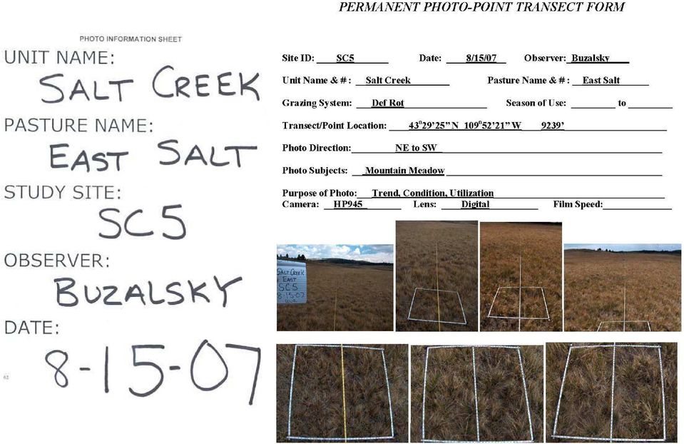
15 PERMANENT PHOTO POINT TRANSECT Site Id Date Observer Unit Name/# Pasture Name Transect Location Photo Direction Photo Subjects Purpose of Photo Camera Info

16 Photo Point Layout General Shots: Stand at the stake, center photo down the transect line, top third should be sky/horizon, both at the 0 stake and 100 stake Close-up Shots: Stand straddling the tape, take picture looking straight down at square. If getting shadows Stand to one side or other of tape

17
18 LANDSCAPE APPEARANCE Procedure: Select a beginning point for a paced transect in key area. Stay within the same veg type & Photograph the area. Observe and record at least 25 samples per transect. Examine the immediate area around you and determine which landscape appearance class most accurately represents the vegetation use and record. At end of transect, total dots, multiply count by class midpoint. Calculate average utilization by dividing the sum of products by the total count. This method estimates general forage utilization. It is especially helpful when grazing or browsing use must be estimated for large areas. For this method, an ocular estimate of forage utilization is based on the general appearance of the rangeland. Utilization levels are determined by comparing observations with the written utilization class descriptions. Utilization estimates are evaluated against the standards, goals, or objectives for the area.

19 LANDSCAPE APPEARANCE Unit Name Pasture Name Transect ID Date/Observer Animal Kind/Class Season of Use Sample Interval Use Classes and Descriptions of Landscape Appearance

20 GRAZING USE MAPS Very useful management tools. Help to identify key areas, distribution problems, or management opportunities. May also be used to modify the grazing management plan. To map utilization, examine the grazing unit and sketch utilization patterns on the map. Landscape appearance observations are often used to develop grazing use maps, Stubble Height can also be used.

21 GRAZING USE MAPS Procedure: Should be done shortly after grazing period. Establish a transect wherever a significant change in use patterns or vegetation type occurs Obtain map of different plant communities or ecological types. When using Landscape appearance map utilization using following classes: 0-5% 61-80% 6-20% 81-94% 21-40% % 41-60% Try not to make areas smaller than 5 Acres, but make notes of area and use. Include a map legend.
22 COVER BY LIFE FORM This is simply an estimation of the relative amounts of different life forms on a site Repeating this data collection over time provides an indication of trend on the site Procedure: Install stakes and stretch 100 tape between them. Take two photos, a closeup and one centered on the 5 mark. Beginning at the 1 mark, lower a pointer until initial contact with vegetation or ground surface is made. Record data on form. Repeat at each foot mark until have 100 points sampled. Life form categories are: grasses, forbs, shrubs, litter, moss & lichen, rock and bare ground. The total number of tallies converts to percent cover for each life form.
23 COVER BY LIFEFORM Unit Name Pasture Name Transect ID Date Observer Lifeform Categories
24 GRAZING RESPONSE INDEX Was developed to describe annual grazing use, interpret annual grazing effects, and to aid in planning the grazing pattern for the following year. Understanding plant physiology and plant response to grazing is essential in the development of unit management plans; with this there is a need for a monitoring tool that adequately estimates rangeland use due to grazing Must not only access how much of the plant was grazed but also when the plant was grazed and how many times it was defoliated during the growing season GRI is an effective tool to access grazing systems or complications associated with situations such as early season big game use followed by livestock use Consequently, GRI is based on general determinations of annual grazing use, and is not intended to be the only method for resolving major conflicts. GRI considers three key concepts related to plant health: frequency, intensity, and opportunity
25 GRAZING RESPONSE INDEX Frequency - the number of times plants are defoliated during grazing period Intensity of defoliation is the amount of leaf material removed during grazing period Opportunity is the amount of time plants have to grow prior to grazing or regrow after grazing. Dependent on the length of time plants are exposed to grazing animals; Approx days required for a plant to re-grow enough to be grazed again during late spring or early summer when plants experiencing rapid growth Utilization; the primary concern is the amount of photosynthetically active leaf material remaining for the plant to recover from grazing Opportunity is the one factor most highly related to long term health and vigor of the vegetation
26 GRAZING RESPONSE INDEX GRI gives a more comprehensive basis to plan future use that will maintain or improve plant health, structure, and vigor Overall Rating of the expected response to grazing is the sum of all three values. The index is a simple method to evaluate whether the grazing system has longterm beneficial, neutral, or harmful effects to the rangeland forage
27 STUBBLE HEIGHT Vegetation provides streambank protection, traps sediments, contributes to rebuilding degraded stream channels, and ensures residual forage and habitat. Retaining an adequate amount of standing herbaceous vegetation (stubble) along the streambanks and within the primary floodplain slows overland water flow velocity from winter and spring runoff, traps and retains sediments necessary to build and maintain streambanks. Occurs on predetermined key species in key areas.
28 STUBBLE HEIGHT Procedure: Measure key species in key area, paced through the area along a predetermined course or transect. Determine how many paces (2 steps) for sample interval and begin pacing the transect. Locate the plant nearest the toe of your boot. Record the average stubble height (leaf length) for each key species. Record a minimum of 36 stubble heights. Total the measurements for each column and divide by the number of plants sampled for each species to get average stubble height.
29 GREENLINE STABILITY Procedure: Locate transect along a stream reach representative of the area and of streams being sampled. The gradient, soil conditions and stream shape should be fairly consistent. Permanently mark the transect, it begins on the right side of the stream (downstream). Take a photo looking down the transect. Sample for 363 feet along the greenline, recording the community encountered at each pace on the form. At the end of the downstream transect, cross and sample the other side back along the upstream greenline (left-side).
30 Dunoir C & H
31 QUESTIONS??
MONITORING RANGELANDS
 MONITORING RANGELANDS A Practical Reference By Scott Cotton CSU Range Management Extension Agent 212 West 12 th Street, Suite 220 Pueblo, CO 81003-2976 (719)583-6566 Scott.Cotton@Colostate.edu Why Should
Increasing water availability through juniper control.
 Tim Deboodt, OSU Crook County Extension Agent 498 SE Lynn Blvd. Prineville, OR 97754 541-447-6228 Tim.deboodt@oregonstate.edu Increasing water availability through juniper control. Throughout the region
STANDARDS FOR RANGELAND HEALTH ASSESSMENT FOR SAGEHEN ALLOTMENT #0208
 STANDARDS FOR RANGELAND HEALTH ASSESSMENT FOR SAGEHEN ALLOTMENT #0208 RANGELAND HEALTH STANDARDS - ASSESSMENT SAGEHEN ALLOTMENT #0208 STANDARD 1 - UPLAND WATERSHED This standard is being met on the allotment.
Travel Time. Computation of travel time and time of concentration. Factors affecting time of concentration. Surface roughness
 3 Chapter 3 of Concentration and Travel Time Time of Concentration and Travel Time Travel time ( T t ) is the time it takes water to travel from one location to another in a watershed. T t is a component
Outlet stabilization structure
 Overview of Sedimentation and Erosion Control Practices Practice no. 6.41 Outlet stabilization structure Erosion at the outlet of channels, culverts, and other structures is common, and can cause structural
Monitoring Riparian Areas With a Camera
 Monitoring Riparian Areas With a Camera By Michael DeLasaux 1, Holly George 2, and Philip Mainwaring 3 Riparian areas are next to streams, springs, rivers, ponds and lakes. Physical characteristics that
Lentic Riparian Monitoring Focused on Objectives. Sherman Swanson University of Nevada Reno
 Lentic Riparian Monitoring Focused on Objectives Sherman Swanson University of Nevada Reno Criteria for Success Focuses management on priorities Practical Elko BLM District has assessed PFC on about half
UGIP Technical Committee Key Principles of Grazing Management
 UGIP Technical Committee Key Principles of Grazing Management Why Grazing Management? Sustain land health and productivity Demonstrate good land stewardship Ensure a future for livestock grazing Monitoring
The importance of ESD concept for rangeland monitoring program and rangeland management in Mongolia
 The importance of ESD concept for rangeland monitoring program and rangeland management in Mongolia Bulgamaa Densambuu, Green Gold, SDC Mongolia Bulgamaa@greengold.mn www.greengold.mn State of Mongolian
GLOSSARY OF TERMS CHAPTER 11 WORD DEFINITION SOURCE. Leopold
 CHAPTER 11 GLOSSARY OF TERMS Active Channel The channel that contains the discharge Leopold where channel maintenance is most effective, sediment are actively transported and deposited, and that are capable
Final Report. Dixie Creek Restoration Project. Funded by Plumas Watershed Forum
 Final Report Dixie Creek Restoration Project Funded by Plumas Watershed Forum Plumas Corporation January 2009 1 Background FR-CRM staff presented this project to the Dixie Valley Landowners Association
Ruby River Grayling - Gravel Spawning Beds Monitoring Report January 2008
 Ruby River Grayling - Gravel Spawning Beds Monitoring Report January 2008 In partnership with Montana Department of Fish, Wildlife, and Parks (FWP), American Wildlands, and Wildlife Forever, the Madison
How To Assess An Area For Erosion
 SKY BASIN (UPPER CA 1 WATERSHED) EROSION ASSESSMENT Prepared by Kevin Drake, CPESC Integrated Environmental Restoration Services, Inc. August 2014 COMMON GROUND UNCOMMON SOLUTIONS P.O. BOX 7559 2780 LAKE
Index. protection. excavated drop inlet protection (Temporary) 6.50.1 6.51.1. Block and gravel inlet Protection (Temporary) 6.52.1
 6.50.1 6.51.1. Block and gravel inlet Protection (Temporary) 6.52.1") 6 Index inlet protection excavated drop inlet protection (Temporary) 6.50.1 HARDWARE CLOTH AND GRAVEL INLET PROTECTION Block and gravel inlet Protection (Temporary) sod drop inlet protection ROCK DOUGHNUT
6 Index inlet protection excavated drop inlet protection (Temporary) 6.50.1 HARDWARE CLOTH AND GRAVEL INLET PROTECTION Block and gravel inlet Protection (Temporary) sod drop inlet protection ROCK DOUGHNUT
1.7.0 Floodplain Modification Criteria
 1.7.0 Floodplain Modification Criteria 1.7.1 Introduction These guidelines set out standards for evaluating and processing proposed modifications of the 100- year floodplain with the following objectives:
Chapter 3 CULVERTS. Description. Importance to Maintenance & Water Quality. Culvert Profile
 Chapter 3 CULVERTS Description A culvert is a closed conduit used to convey water from one area to another, usually from one side of a road to the other side. Importance to Maintenance & Water Quality
WETLAND RESTORATION PROGRAM WATER ACT APPROVAL ADMINISTRATIVE GUIDE
 WETLAND RESTORATION PROGRAM WATER ACT APPROVAL ADMINISTRATIVE GUIDE May 24, 2005 Table of Contents Introduction...3 Definitions...3 Types of Wetland Restorations...4 Re-Contouring...4 Engineered...4 Water
General Permit for Activities Promoting Waterway - Floodplain Connectivity [working title]
![General Permit for Activities Promoting Waterway - Floodplain Connectivity [working title]](/thumbs/39/18645965.jpg "General Permit for Activities Promoting Waterway - Floodplain Connectivity [working title]") General Permit for Activities Promoting Waterway - Floodplain Connectivity [working title] Purpose These rules set forth the conditions under which a person may, without an individual removal-fill permit
General Permit for Activities Promoting Waterway - Floodplain Connectivity [working title] Purpose These rules set forth the conditions under which a person may, without an individual removal-fill permit
Post-Wildfire Clean-Up and Response in Houston Toad Habitat Best Management Practices
 Post-Wildfire Clean-Up and Response in Houston Toad Habitat Best Management Practices Purpose The purpose of this document is to provide guidance and recommendations for minimizing potential impacts to
Prepared By: Tom Parker Geum Environmental Consulting, Inc.
 Prepared By: Tom Parker Geum Environmental Consulting, Inc. Topics covered: Definition of riparian and floodplain restoration Floodplain attributes as a basis for developing criteria for restoration designs
Prattsville Berm Removal Project. 1.0 Project Location
 Prattsville Berm Removal Project 1.0 Project Location The project site is located between the New York State Route 23 Bridge over the Schoharie Creek and the Schoharie Reservoir. The restoration plan encompassed
Estuary monitoring by communities
 Estuary monitoring by communities Mangrove habitats a case study Anne-Maree Schwarz NIWA Sharon Parker, Michael Grose Waikaraka Estuary Managers Introduction Flow chart of actions Example timetable These
Neversink River East Branch
 Neversink River East Branch Management Unit 10 Summary of Post-Flood Recommendations Intervention Level Full restoration of the stream reach including the eroding bank site between Station 38380 and Station
Floodplain Connectivity in Restoration Design
 Floodplain Connectivity in Restoration Design 2015 Symposium on Restoration in a Contaminated Environment: Lessons Learned and Challenges in Moving Forward Part II April 2015 Karin Boyd Applied Geomorphology,
PRESCRIBED GRAZING NATURAL RESOURCES CONSERVATION SERVICE CONSERVATION PRACTICE STANDARD. (Acre) Code 528
 Code 528") NATURAL RESOURCES CONSERVATION SERVICE CONSERVATION PRACTICE STANDARD PRESCRIBED GRAZING (Acre) Code 528 DEFINITION Managing the harvest of vegetation with grazing and/or browsing animals. PURPOSE Improve
NATURAL RESOURCES CONSERVATION SERVICE CONSERVATION PRACTICE STANDARD PRESCRIBED GRAZING (Acre) Code 528 DEFINITION Managing the harvest of vegetation with grazing and/or browsing animals. PURPOSE Improve
Assessing Rivers for Restoration Purposes. Ann L. Riley Waterways Restoration Institute
 Assessing Rivers for Restoration Purposes Ann L. Riley Waterways Restoration Institute Assessing Rivers for Restoration Purposes Ann L. Riley Waterways Restoration Institute Assessing Rivers for Restoration
Stream Rehabilitation Concepts, Guidelines and Examples. Objectives. Pierre Y. Julien. Three Laws of Stream Restoration
 Stream Rehabilitation Concepts, Guidelines and Examples Pierre Y. Julien Wuhan 2005 Objectives Part I - Stream restoration and rehabilitation: 1. Present and discuss important concepts, laws, criteria
URBAN DRAINAGE CRITERIA
 URBAN DRAINAGE CRITERIA I. Introduction This division contains guidelines for drainage system design and establishes a policy for recognized and established engineering design of storm drain facilities
Passive Restoration 101: Framework and Techniques Overview. Amy Chadwick, Great West Engineering August 26, 2015 Butte, America
 Passive Restoration 101: Framework and Techniques Overview Amy Chadwick, Great West Engineering August 26, 2015 Butte, America What Defines Passive Restoration? Process-based, nature-driven Minimal equipment
Prioritizing Riparian Restoration at the Watershed, Reach and Site Scales. Richard R. Harris University of California, Berkeley Cooperative Extension
 Prioritizing Riparian Restoration at the Watershed, Reach and Site Scales Richard R. Harris University of California, Berkeley Cooperative Extension Issues Riparian communities provide multiple benefits
Sagebrush steppe post-fire rehabilitation projects: Using the past to guide the future
 Forest and Rangeland Ecosystem Science Center Sagebrush steppe post-fire rehabilitation projects: Using the past to guide the future David A. Pyke, U.S. Department of the Interior U.S. Geological Survey
Land Disturbance, Erosion Control and Stormwater Management Checklist. Walworth County Land Conservation Department
 Land Disturbance, Erosion Control and Stormwater Management Checklist Walworth County Land Conservation Department The following checklist is designed to assist the applicant in complying with the Walworth
Basic Hydrology. Time of Concentration Methodology
 Basic Hydrology Time of Concentration Methodology By: Paul Schiariti, P.E., CPESC Mercer County Soil Conservation District What is the Time of Concentration? The time it takes for runoff to travel from
Emergency Spillways (Sediment basins)
") Emergency Spillways (Sediment basins) DRAINAGE CONTROL TECHNIQUE Low Gradient Velocity Control Short-Term Steep Gradient Channel Lining Medium-Long Term Outlet Control Soil Treatment Permanent [1] [1]
Emergency Spillways (Sediment basins) DRAINAGE CONTROL TECHNIQUE Low Gradient Velocity Control Short-Term Steep Gradient Channel Lining Medium-Long Term Outlet Control Soil Treatment Permanent [1] [1]
Objectives. Raster Data Discrete Classes. Spatial Information in Natural Resources FANR 3800. Review the raster data model
 Spatial Information in Natural Resources FANR 3800 Raster Analysis Objectives Review the raster data model Understand how raster analysis fundamentally differs from vector analysis Become familiar with
CITY UTILITIES DESIGN STANDARDS MANUAL
 CITY UTILITIES DESIGN STANDARDS MANUAL Book 2 (SW) SW9 June 2015 SW9.01 Purpose This Chapter provides information for the design of open channels for the conveyance of stormwater in the City of Fort Wayne.
Soakage Trenches. A better way to manage stormwater. Thinking Globally and Acting Locally
 Soakage Trenches A better way to manage stormwater Thinking Globally and Acting Locally A partnership of the Scranton Sewer Authority, The Lackawanna River Corridor Association and the citizens of Scranton
Follow the Drop. Activity Overview Students observe and collect information about water runoff on their school property. Objective Students will:
 Follow the Drop Activity Overview Students observe and collect information about water runoff on their school property. Objective Students will: Practice observation and investigative skills Survey and
Chapter 11 Site Rehabilitation and Stabilization
 Chapter 11 Site Rehabilitation and Stabilization Chapter 11 Layout: Part 1 - Page 131 Planning Site Rehab Part 2 - Page 132 Controlling Runoff and Capturing Sediment Part 3 - Page 133 Rehab for Crossings
The students will be working in and alongside the stream, so safety is a consideration. Suitable sites should have the following characteristics:
 Measuring Stream Banks: Height and Slope Stream bank heights and slopes are of interest because they yield information relevant to bank erosion and stability. A high, steep bank is likely to be unstable
R E S T R I C T E D B R E E D I N G A N D R O T A T I O N A L G R A Z I N G
 R E S T R I C T E D B R E E D I N G A N D R O T A T I O N A L G R A Z I N G J O R G E L U I S S A N C H E Z B R I C E Ñ O H E R M O S I L L O S O N O R A M E X I C O The problem that is always faced in
How To Plan A Buffer Zone
 Backyard Buffers Protecting Habitat and Water Quality What is a buffer? A buffer (also called a riparian buffer area or zone) is the strip of natural vegetation along the bank of a stream, lake or other
ImpRovIng and SuStaInIng FoRage production In pastures S RC n
 Improving and Sustaining Forage Production in Pastures nrcs Improving and Sustaining Forage Production in PAStures June 2010 Prepared by Minnesota Department of Agriculture Written by Howard Moechnig,
Communities, Biomes, and Ecosystems
 Communities, Biomes, and Ecosystems Before You Read Before you read the chapter, respond to these statements. 1. Write an A if you agree with the statement. 2. Write a D if you disagree with the statement.
Low Impact Development Checklist
 New Jersey Stormwater Best Management Practices Manual February 2004 A P P E N D I X A Low Impact Development Checklist A checklist for identifying nonstructural stormwater management strategies incorporated
Set up your Database. Contents
 Set up your Database Contents Basic DIMA Concepts... 2 Sites, Plots, and Lines... 2 Methods... 4 Geographic Information... 4 Species Lists... 4 Tags... 5 Tips for Successfully using DIMA... 6 Close vs.
Ponds- Planning, Design, Construction
 United States Department of Agriculture Soil Conservation Service Agriculture Handbook Number 590 Ponds- Planning, Design, Construction This handbook describes the requirements for building a pond. It
Restoring Anadromous Fish Habitat in Big Canyon Creek Watershed. Summary Report 2002
 Restoring Anadromous Fish Habitat in Big Canyon Creek Watershed Summary Report 2002 DOE/BP-00005268-5 November 2002 This Document should be cited as follows: "Restoring Anadromous Fish Habitat in Big Canyon
What Is Holistic Planned Grazing?
 What Is Holistic Planned Grazing? Holistic Planned Grazing is a planning process for dealing simply with the great complexity livestock managers face daily in integrating livestock production with crop,
CHAPTER 3 STORM DRAINAGE SYSTEMS
 CHAPTER 3 STORM DRAINAGE SYSTEMS 3.7 Storm Drains 3.7.1 Introduction After the tentative locations of inlets, drain pipes, and outfalls with tail-waters have been determined and the inlets sized, the next
Monitoring Hydrological Changes Related to Western Juniper Removal: A Paired Watershed Approach
 Monitoring Hydrological Changes Related to Western Juniper Removal: A Paired Watershed Approach T.L. Deboodt, M.P. Fisher, J.C. Buckhouse, John Swanson Abstract Since 1934, western juniper has increased
Interim Technical Guidelines for the Development of Environmental Management Plans for Underground Infrastructure Revised - July 2013.
 Interim Technical Guidelines for the Development of Environmental Management Plans for Underground Infrastructure Revised - July 2013 Rationale Underground infrastructure may be at risk from valley, streambank
Rural Flooding: The Potential Role of Forestry
 Rural Flooding: The Potential Role of Forestry Nadeem Shah, Tom Nisbet, & Huw Thomas Centre for Forestry and Climate Change Structure Background Woodland and Flood Alleviation The Theory. Studies on Woodland
Addendum. Use Attainability Analysis for Site Specific Selenium Criteria: Alkali Creek. February 23, 2009
 Addendum Use Attainability Analysis for Site Specific Selenium Criteria: Alkali Creek February 23, 2009 Prepared by MWH Americas, Inc. Prepared for EnCana Oil and Gas (USA) Inc. Page 2 Responses to Comments
Minimizes sediment and debris from entering storm drains that lead to waterways and watercourses.
 4.5-p DRAIN INLET PROTECTION Alternative Names: DI protection, Drop Inlet Protection DESCRIPTION Storm drain inlet (DI) protection slows and ponds stormwater, and filters sediment and debris before it
1 Introduction. 1.1 Key objective. 1.2 Why the South Esk
 1 Introduction 1.1 Key objective The aim of this study is to identify and assess possible options for improving the quality of the river channel and habitats in the River South Esk catchment whilst helping
Angora Fire Restoration Activities June 24, 2007. Presented by: Judy Clot Forest Health Enhancement Program
 Angora Fire Restoration Activities June 24, 2007 Presented by: Judy Clot Forest Health Enhancement Program California Tahoe Conservancy Independent California State Agency within the Resources Agency Governed
Summary of Pre- and Post-Project Vegetation Survey Results
 3921 East Bayshore Road Palo Alto CA 94303-4326 tel 650.962.9876 fax 650.962.8234 www.acterra.org info@acterra.org Introduction Summary of Pre- and Post-Project Vegetation Survey Results Acterra Stewardship
5.0 OVERVIEW OF FLOOD DAMAGE REDUCTION MEASURES
 5.0 OVERVIEW OF FLOOD DAMAGE REDUCTION MEASURES Flood damage reduction consists of two basic techniques structural and non-structural. Structural methods modify the flood and take the flood away from people
The Basics of Chapter 105 Waterways and Wetlands Permitting in PA
 The Basics of Chapter 105 Waterways and Wetlands Permitting in PA April 17, 2013 Goal To develop a basic understanding of PA Department of Environmental Protection (DEP) and US Army Corps of Engineers
Standards Oversight Council (SOC) Supporting Technical Standards for Urban and Rural Soil and Water Conservation
 Supporting Technical Standards for Urban and Rural Soil and Water Conservation") Standards Oversight Council (SOC) Supporting Technical Standards for Urban and Rural Soil and Water Conservation 702 E. Johnson Street, Madison, Wisconsin 53703 (608) 441-2677 Fax (608) 441-2676 soc@wlwca.org
Standards Oversight Council (SOC) Supporting Technical Standards for Urban and Rural Soil and Water Conservation 702 E. Johnson Street, Madison, Wisconsin 53703 (608) 441-2677 Fax (608) 441-2676 soc@wlwca.org
DESIGNING YOUR LANDSCAPE
 DESIGNING YOUR LANDSCAPE SITE AND NEEDS ASSESSMENT Examine all existing features of your site that could affect your landscape design and then identify the functions you want your landscape to serve. Site
SUSTAINABLE URBAN DRAINAGE SYSTEMS
 overflow can lead into a permeable conveyance system to increase further the benefit and reduce the need for pipe systems. Pollutant removal rates have been shown to be high, with some pollutants being
CHAPTER 3A Environmental Guidelines for STREAM CROSSING BY ALL-TERRAIN VEHICLES
 GOVERNMENT OF NEWFOUNDLAND AND LABRADOR DEPARTMENT OF ENVIRONMENT AND LABOUR CHAPTER 3A Environmental Guidelines for STREAM CROSSING BY ALL-TERRAIN VEHICLES WATER RESOURCES MANAGEMENT DIVISION Water Investigations
Various options are discussed below.these low cost, low impact interventions can also be applied as general erosion control methods.
 Week 10 River Hydraulics Rehabilitating Urban Waterways (From http://hubpages.com/hub/river-bank-erosion-control-methods) See also the resources placed on Moodle. Water channels should be viewed as a resource
Water Quality Management
 Water Quality Management Sustainable agriculture practices detailed in other sections of this publication are important ways to maintain or improve water quality on the farm and downstream from the farm.
THE POND-AND-PLUG TREATMENT FOR STREAM AND MEADOW RESTORATION: RESOURCE EFFECTS AND DESIGN CONSIDERATIONS
 THE POND-AND-PLUG TREATMENT FOR STREAM AND MEADOW RESTORATION: RESOURCE EFFECTS AND DESIGN CONSIDERATIONS A Briefing Paper for Plumas National Forest Resource Specialists and Managers The Red Clover McReynolds
Manipulating feral goat access to water in the Rangelands
 Manipulating feral goat access to water in the Rangelands Russell, B. G. 1, Letnic, M. 2, and Fleming, P. J. S. 3 1 Pest Management Unit, Department of Environment, Climate Change and Water, PO Box 1967,
Text and photos: Juha Siekkinen, Life+ Return of Rural Wetlands Cover drawing: Jari Kostet Maps and aerial photos: National Land Survey of Finland
 Life+ Return of Rural Wetlands Pikku Nuoluanjärvi Wetlands, Liminka Text and photos: Juha Siekkinen, Life+ Return of Rural Wetlands Cover drawing: Jari Kostet Maps and aerial photos: National Land Survey
Growth of Pasture Plants
 Growth of Pasture Plants 3 GREG J. BISHOP-HURLEY In a grazing situation it is important to understand both how plants function and their form and structure. Every plant growth response is caused by a series
CyberTracker. Step-by-Step Tutorial. How to Customise a Wildlife Monitoring Application
 CyberTracker Step-by-Step Tutorial How to Customise a Wildlife Monitoring Application This tutorial will demonstrate how to customise a CyberTracker Wildlife Monitoring and Line Transect Survey Application.
Adopted 9/23/98 CHATTAHOOCHEE CORRIDOR PLAN. The goals of the Chattahoochee Corridor Plan (hereinafter also referred to as the Plan ) are:
 are:") CHATTAHOOCHEE CORRIDOR PLAN Adopted 9/23/98 PART 1: GOALS. POLICY. COVERAGE. A. Goals The goals of the Chattahoochee Corridor Plan (hereinafter also referred to as the Plan ) are: 1. Preservation and protection
CHATTAHOOCHEE CORRIDOR PLAN Adopted 9/23/98 PART 1: GOALS. POLICY. COVERAGE. A. Goals The goals of the Chattahoochee Corridor Plan (hereinafter also referred to as the Plan ) are: 1. Preservation and protection
Resource Investment Optimization System (RIOS)
") NATURAL CAPITAL PROJECT Resource Investment Optimization System (RIOS) v1.1.0 Introduction & Theoretical Documentation Step-by-Step User s Guide Resource Investment Optimization System Introduction & Theoretical
NATURAL CAPITAL PROJECT Resource Investment Optimization System (RIOS) v1.1.0 Introduction & Theoretical Documentation Step-by-Step User s Guide Resource Investment Optimization System Introduction & Theoretical
Storm Drainage Systems 11.9-1
 Storm Drainage Systems 11.9-1 11.9 Gutter Flow Calculations 11.9.1 Introduction Gutter flow calculations are necessary in order to relate the quantity of flow (Q) in the curbed channel to the spread of
Flood Protection in Garland Past, Present, and Future. Presented by: R. Lyle Jenkins, P.E., CFM City of Garland, Texas
 Flood Protection in Garland Past, Present, and Future Presented by: R. Lyle Jenkins, P.E., CFM City of Garland, Texas A few facts about Garland: Originally incorporated in 1891 Population 226,876 (2010
The function buttons Settings. Settings
 Settings Device wizard Using the device wizard you can change the type of trainer you want to connect. Select the right trainer image, click Next and go through the next steps to connect your trainer in
 Coldwater Heritage Partnership Implementation Grant Final Report Morrison Run Watershed Restoration Project Western Pennsylvania Conservancy Project Summary The goal of the Morrison Run Watershed Restoration
EMERGENCY HOME PROTECTION. Homeowner's Guide for Emergency Flood Control. Contents INTRODUCTION
 EMERGENCY HOME PROTECTION Homeowner's Guide for Emergency Flood Control Contents Discussion or Section Page Number Introduction 3 Potential Flooding Periods 4 General Rules and Control Aids 5,6 Sandbags
COMPLIANCE REPORT MUDDY HOLLOW CULVERT REMOVAL FILE NUMBER 25358N
 COMPLIANCE REPORT MUDDY HOLLOW CULVERT REMOVAL FILE NUMBER 25358N Submitted by the National Park Service Point Reyes National Seashore Point Reyes Station, California, 94956 Project Description: Muddy
Colorado Natural Heritage Program
 CNHP s mission is to preserve the natural diversity of life by contributing the essential scientific foundation that leads to lasting conservation of Colorado's biological wealth. Colorado Natural Heritage
Glen Dhu Power Wind Project Addendum to Glen Dhu Environmental Assessment and Registration Document
 Glen Dhu Power Wind Project Addendum to Glen Dhu Environmental Assessment and Registration Document APPENDIX C: SHEARWIND GLEN DHU MONITORING PROTOCOLS FOR MAINLAND MOOSE SHEARWIND GLEN DHU MONITORING
Tennessee Watershed Modeling Tools. Southern Region Watershed Meeting, July 2005. Forbes Walker University of Tennessee Extension
 Tennessee Watershed Modeling Tools Southern Region Watershed Meeting, July 2005 Forbes Walker University of Tennessee Extension Outline Land Use and Water Quality in Tennessee Watershed models Watershed
P-23 - DEVELOPMENT OF DELAWARE DEPARTMENT OF TRANSPORTATION STORMWATER BEST MANAGEMENT PRACTICE INSPECTION PROGRAM
 P-23 - DEVELOPMENT OF DELAWARE DEPARTMENT OF TRANSPORTATION STORMWATER BEST MANAGEMENT PRACTICE INSPECTION PROGRAM A. INTRODUCTION Peter Mattejat, PE KCI Technologies, Inc.; Laurel, Maryland Bruce Thompson
Town of Elkton & Cecil Soil Conservation District Checklist for Joint Agency Review Stormwater Management / Erosion and Sediment Control
 Town of Elkton & Cecil Soil Conservation District Checklist for Joint Agency Review Stormwater Management / Erosion and Sediment Control Project Name: Tax Map Parcel: Acreage: Plat: ADC Map & Grid Engineering
Storm Drain Inlet Protection
 Objectives EC Erosion Control SE Sediment Control TR Tracking Control WE Wind Erosion Control Non-Stormwater NS Management Control Waste Management and WM Materials Pollution Control Legend: Primary Objective
Thank you to all of our 2015 sponsors: Media Partner
 Thank you to all of our 2015 sponsors: Media Partner Channel Naturalization: Planning and Implementation in Peel Region TRIECA March 25 & 26, 2015 Peel Region Channel Remediation Strategy An Urban Context
King County Flood Hazard Management Plan Update Cedar/ Sammamish Rivers. Public Meeting December 5, 2012
 King County Flood Hazard Management Plan Update Cedar/ Sammamish Rivers Public Meeting December 5, 2012 Goals of the Presentation Cedar and Sammamish R. Plan Update Context - Brief summary info about the
CALCULATING AVAILABLE FORAGE
 CALCULATING AVAILABLE FORAGE Mindy Pratt and G. Allen Rasmussen Range Management Fact Sheet May 2001 NR/RM/03 An important part of calculating Stocking Rate is knowing the amount of available forage you
Addendum D. Nomination of Moody Wash ACEC
 Addendum D Nomination of Moody Wash ACEC Moody Wash ACEC is hereby nominated by Citizens for Dixie s Future to: BLM St. George Field Office 345 East Riverside Drive St. George, UT 84790 Moody Wash is a
DOÑA ANA COUNTY DESIGN STORM CRITERIA GUIDELINES FOR COMMERCIAL AND RESIDENTIAL SITES. Run-off Analysis Methods
 DOÑA ANA COUNTY DESIGN STORM CRITERIA GUIDELINES FOR COMMERCIAL AND RESIDENTIAL SITES Run-off Analysis Methods This document sets forth the minimum design, technical criteria and specifications for the
RouteShoot Users Guide Android
 RouteShoot Users Guide Android Background The RouteShoot Android application draws together 3 phone features ( Video, GPS and Maps ) to provide you with a tool that will let you capture your videos, synchronised
The Teton Creek Restoration Project Summary:
 The Teton Creek Restoration Project Summary: The Teton Creek Restoration Project area extends for approximately one mile upstream from the Cemetery Road Bridge and includes the Aspen Pointe, The Aspens
City of Paso Robles Community Development Department Construction Site Storm Water Quality Requirements
 City of Paso Robles Community Development Department Construction Site Storm Water Quality Requirements Overview of the City s Construction Storm Water Program The City of Paso Robles is committed to protecting
Mountainous forest watershed management Governance in Greece
 Mountainous forest watershed management Governance in Greece Katerina Koutla Forester Ministry of Environment, Energy and Climate Change Alcala de Henares, 28 29 January 2014 Central Forest Service Ministry
BSc in Environmental and Conservation Sciences Wildlife and Rangeland Resources Management Major
 Faculty of Agricultural, Life & Environmental Sciences Undergraduate Student Services 2-31 General Services Building www.ales.ualberta.ca Tel: 780.492.4933 Edmonton, Alberta, Canada T6G 2H1 new2ales@ualberta.ca
STORMWATER MANAGEMENT CHECKLIST
 STORMWATER MANAGEMENT CHECKLIST *This checklist must be completed and part of the Land Disturbing Permit submittal for review if the acreage disturbed is one (1) acre or more: I. SUPPORTING DATA Narrative
Pima County Range Management Standards and Guidelines
 Pima County Range Management Standards and Guidelines Pima County Natural Resources, Parks and Recreation 3500 West River Road Tucson, AZ 85741 www.pima.gov/nrpr Table of Contents Introduction..............................................................................................
3.4 DRAINAGE PLAN. 3.4.1 Characteristics of Existing Drainages. 3.4.2 Master Drainage System. Section 3: Development Plan BUTTERFIELD SPECIFIC PLAN
 3.4 DRAINAGE PLAN This section describes the existing onsite drainage characteristics and improvements proposed within this Specific Plan. Following this description, drainage plan development standards
Lesson 3: Fish Life Cycle
 Lesson 3: Fish Life Cycle Activity: Diagram fish life cycle. Grade level: 4-8 Subjects: Science, social studies Setting: Classroom Duration: 50 minutes Key Terms: Fry, life cycle, life history, spawn,
Appendix To Operational Review and Recommendations For Juniper Golf Course
 Appendix To Operational Review and Recommendations For Juniper Golf Course Prepared For: City of Redmond Attn: David Brandt 716 SW Evergreen Street Redmond, OR 97756 Prepared By: 1150 South U.S. Highway