HYCOM Data Management -- opportunities & planning --
|
|
|
- Christal Parsons
- 10 years ago
- Views:
Transcription
1 HYCOM Data Management -- opportunities & planning -- Steve Hankin (NOAA/PMEL) Ashwanth Srinivasan, (RSMAS) Peter Cornillon, OPeNDAP PI (URI) Mike Clancy, US GODAE Server (FNMOC) Jon Callahan, Kevin O Brien (U.Washington/JISAO) Roland Schweitzer (Weathertop Consulting), Ansley Manke (NOAA/PMEL) The OPeNDAP developers Phil Sharfstein, Dave Dimitriou (FNMOC) Dec. 05 HYCOM National Meeting December, 2005 Steve Hankin
 Roland Schweitzer (Weathertop Consulting), Ansley Manke (NOAA/PMEL) The OPeNDAP")
2 Live Access Server (LAS) a configurable server

3
4

5
6 Desktop: Matlab, IDL, IDV, Ferret, GrADS, Information Products netcdf, HYCOM binary, ASCII, GIS layers

7

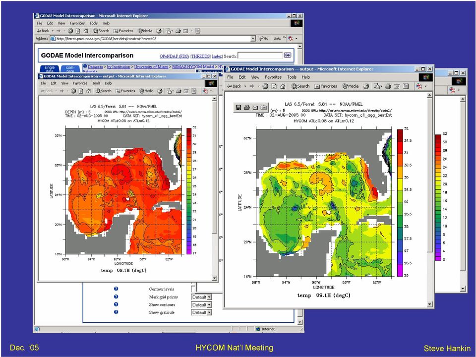
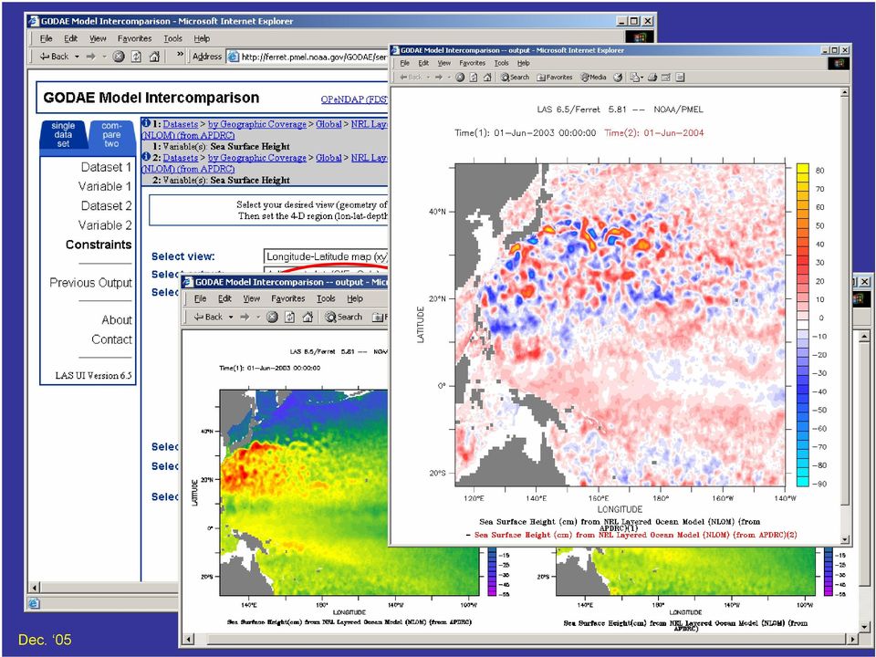
8 Compare fields
9 On-the-fly regridding from curvilinear to rectilinear coordinates

10 Similarly from hybrid-z to rectilinear

11 Simple analysis capabilities

12 HYCOM data at the desktop (for Matlab, IDL, Ferret, GrADS, ) The remote dataset is just a filename FDS is an OPeNDAP server standardizes datasets can perform analyses Vertical average of variable TEMP

13 FDS Delayed evaluation The whole domain appears to be transformed Calculations are on-demand, surgical Can greatly reduce network data volumes Can provide regridding on-the-fly

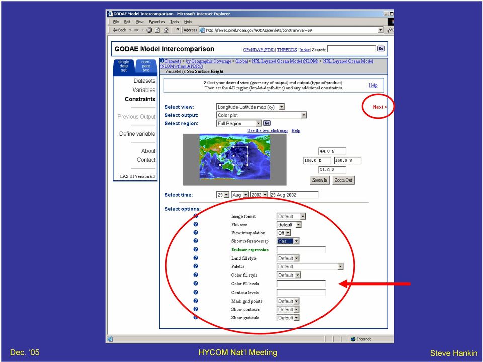
14 Ocean obs via LAS (incl. custom constraints )

15 GTS Ocean obs on US GODAE Server

16 OPeNDAP: network access to data and semantic metadata

17 Demanding (large) products may be created in batch mode

18 Scripted access to LAS Query available data sets: >lasls Query variables in data set model_1 : >lasls model_1 Query space-time domain: >lasls model_1 sst Request a subset of data as a file: ( asc for ASCII format) >lasget -x x 20:60 -y y 20:60 -t t 11-Dec Dec f asc model_1 sst
 >lasget -x x 20:60 -y y 20:60 -t t 11-Dec Dec-2000 -f asc")
19 LAS -- an Information Product Server LAS UI Browser NetScape Internet 1 2 LAS UI server (java) LAS product server (perl) Java Metadata Internet (OPenDAP) 3 Depth 4 e.g. work CDAT (Python/LLNL), application HYCOM viz, Local Data Remote Data Temp XML Metadata contains the intelligence Back end applications do the real work OPeNDAP provides remote data access New: Back end application via SOAP Web Service

20 HYCOM is ready for integration with other data serving activities

21 Outreach example: PRIDE Pacific Regional Integrated Data Environment
22 HYCOM information & data portal Information access Uniform data access home Area 1 Area 2 Area 3 Project 1 Project 2 Project 3 Project 4 Exp 1 Exp 1 Exp 2 Exp 2 Live Access Server
23 Collaborating sister servers site 1 site 2 LAS Meta LAS Meta Data Data LAS UI NetScape LAS user interface Meta Meta Meta Meta VIRTUAL server LAS Meta LAS Meta Data Data site 3 site 4 Comparison between datasets becomes straightforward: Servers request regridded data from one another via FDS.
24 for breakout: next steps Two categories of data management service: 1. Inward: for HYCOM Consortium members: provide forcing fields for "downscaling" intra-consortium collaboration & interaction tools access to validation data satellite fields, climatologies, other models, in-situ 2. Outward: for others the research community the "IOOS" (end user) community potential new HYCOM modelers
25 to think about: How to make "downscaling" simpler New products or services to add e.g. standard HYCOM viz New data to add validation friendly (regridded) fields Places we should advertise our data Potential users we should contact Systematic archive strategy e.g. High performance access to surface fields (Breakout discussions to follow )
26 Discussion? Questions?
27 Some areas to think about: How to make "downscaling" simpler New products or services to ad GIS layers HYCOM viz. New data to add validation friendly (regridded) fields Places we should advertise ourselves Potential users we should contact Systematic archive strategy -- especially easy access to HYCOM surface fields Reduced suite of variables (u,v,t,s,layer thickness) canonical vertical sections GUIs for Matlab & IDL Collaborative framework for assimilation investigations (mini-godae) Web site, including model descriptions Ability to compare results How to create a controlled environment for assimilation data Other metadata to add for on-line access (model configurations) Data retention periods for forecasts? (N. Atlantic, Pacific, global)
HYCOM Meeting. Tallahassee, FL
 HYCOM Data Service An overview of the current status and new developments in Data management, software and hardware Ashwanth Srinivasan & Jon Callahan COAPS FSU & PMEL HYCOM Meeting Nov 7-9, 7 2006 Tallahassee,
Development and Support for the USGODAE Server
 Development and Support for the USGODAE Server Mr. Mike Clancy Fleet Numerical Meteorology and Oceanography Center 7 Grace Hopper Ave, Stop 1 Monterey, CA 93943-5501 phone: (831) 656-4414 fax: (831) 656-4489
The Arctic Observing Network and its Data Management Challenges Florence Fetterer (NSIDC/CIRES/CU), James A. Moore (NCAR/EOL), and the CADIS team
, James A. Moore (NCAR/EOL), and the CADIS team") The Arctic Observing Network and its Data Management Challenges Florence Fetterer (NSIDC/CIRES/CU), James A. Moore (NCAR/EOL), and the CADIS team Photo courtesy Andrew Mahoney NSF Vision What is AON? a
The Arctic Observing Network and its Data Management Challenges Florence Fetterer (NSIDC/CIRES/CU), James A. Moore (NCAR/EOL), and the CADIS team Photo courtesy Andrew Mahoney NSF Vision What is AON? a
Structure? Integrated Climate Data Center How to use the ICDC? Tools? Data Formats? User
 Integrated Climate Data Center? Data Formats?? Tools???? visits Structure???? User Contents Which Data Formats do we offer? What is the Structure of our data center? Which Tools do we provide? Our Aims
SRS BIO OPTICAL WORKFLOW
 SRS BIO OPTICAL WORKFLOW Version 2.0 22 nd March 2013 Data Workflows emii, the data management facility for IMOS, has developed workflows for each IMOS sub facility to describe the flow of IMOS data from
A beginners guide to accessing Argo data. John Gould Argo Director
 A beginners guide to accessing Argo data John Gould Argo Director Argo collects salinity/temperature profiles from a sparse (average 3 x 3 spacing) array of robotic floats that populate the ice-free oceans
Real-time Ocean Forecasting Needs at NCEP National Weather Service
 Real-time Ocean Forecasting Needs at NCEP National Weather Service D.B. Rao NCEP Environmental Modeling Center December, 2005 HYCOM Annual Meeting, Miami, FL COMMERCE ENVIRONMENT STATE/LOCAL PLANNING HEALTH
Data Management Handbook
 Data Management Handbook Last updated: December, 2002 Argo Data Management Handbook 2 TABLE OF CONTENTS 1. INTRODUCTION...4 2. GLOBAL DATA FLOW...5 3. RESPONSIBILITIES...6 3.1. NATIONAL CENTRES:...6 3.2.
ICES Guidelines for Profiling Float Data (Compiled January 2001; revised April 2006)
") ICES Guidelines for Profiling Float Data (Compiled January 2001; revised April 2006) Profiling floats are neutrally buoyant devices that periodically surface to transmit data to a satellite system. The
ICES Guidelines for Profiling Float Data (Compiled January 2001; revised April 2006) Profiling floats are neutrally buoyant devices that periodically surface to transmit data to a satellite system. The
PART 1. Representations of atmospheric phenomena
 PART 1 Representations of atmospheric phenomena Atmospheric data meet all of the criteria for big data : they are large (high volume), generated or captured frequently (high velocity), and represent a
THREDDS. THematic Real-time Environmental Distributed Data Services. Connecting people, documents and data
 THREDDS THematic Real-time Environmental Distributed Data Services Connecting people, documents and data Ben Domenico, John Caron, Ethan Davis, Robb Kambic, Stefano Nativi Unidata Program Center and University
Coriolis data-centre an in-situ data portail for operational oceanography. http://www.coriolis.eu.org [email protected]
 Coriolis data-centre an in-situ data portail for operational oceanography Ingrid Puillat on behalf of L. Petit de la Villeon & G. Maudire IFREMER http://www.coriolis.eu.org [email protected] 1 How did Coriolis
StormSurgeViz: A Visualization and Analysis Application for Distributed ADCIRC-based Coastal Storm Surge, Inundation, and Wave Modeling
 : A Visualization and Analysis Application for Distributed ADCIRC-based Coastal Storm Surge, Inundation, and Wave Modeling Brian Blanton Renaissance Computing Institute University of North Carolina at
13.2 THE INTEGRATED DATA VIEWER A WEB-ENABLED APPLICATION FOR SCIENTIFIC ANALYSIS AND VISUALIZATION
 13.2 THE INTEGRATED DATA VIEWER A WEB-ENABLED APPLICATION FOR SCIENTIFIC ANALYSIS AND VISUALIZATION Don Murray*, Jeff McWhirter, Stuart Wier, Steve Emmerson Unidata Program Center, Boulder, Colorado 1.
Data Products via TRMM Online Visualization and Analysis System
 Accessing Global Precipitation Data Products via TRMM Online Visualization and Analysis System (TOVAS) Zhong Liu Center for Spatial Information Science and Systems (CSISS), George Mason University and
Steve Ansari *, Stephen Del Greco, Brian Nelson, and Helen Frederick NOAA National Climatic Data Center, Asheville, North Carolina 2.
 11.4 THE SEVERE WEATHER DATA INVENTORY (SWDI): SPATIAL QUERY TOOLS, WEB SERVICES AND DATA PORTALS AT NOAA S NATIONAL CLIMATIC DATA CENTER (NCDC) Steve Ansari *, Stephen Del Greco, Brian Nelson, and Helen
Managing Bathymetry in the Cloud with GIS
 Esri Maritime Professional Services GEBCO Science Day Tuesday, October 4, 2011 Managing Bathymetry in the Cloud with GIS Timothy Kearns & Beata Van Esch Overview The challenges of bathymetry in GIS - What
Interactive Data Visualization with Focus on Climate Research
 Interactive Data Visualization with Focus on Climate Research Michael Böttinger German Climate Computing Center (DKRZ) 1 Agenda Visualization in HPC Environments Climate System, Climate Models and Climate
Satellite Products and Dissemination: Visualization and Data Access
 Satellite Products and Dissemination: Visualization and Data Access Gregory Leptoukh GES DISC, NASA GSFC Dana Ostrenga GES DISC, NASA GSFC Introduction The Goddard Earth Sciences Data and Information Services
Maximising the utility of OpeNDAP datasets through the NetCDF4 API
 Maximising the utility of OpeNDAP datasets through the NetCDF4 API Stephen Pascoe ([email protected]) Chris Mattmann ([email protected]) Phil Kershaw ([email protected]) Ag
Benchmarking OPeNDAP services for modern ESM data workloads
 Benchmarking OPeNDAP services for modern ESM data workloads Stephen Pascoe ([email protected]) Richard Wilkinson (Tessella plc. Abingdon, UK) Phil Kershaw ([email protected]) 1 BADC: British
Space Physics Interactive Data Resource SPIDR. Web Services Guide REST API v1,v2
 Space Physics Interactive Data Resource SPIDR Web Services Guide REST API v1,v2 Version 3.0 May 2010 Contents Contents...2 Introduction...3 Data Sources...3 Data Source Interface...3 Basic REST API Summary...4
The distribution of marine OpenData via distributed data networks and Web APIs. The example of ERDDAP, the message broker and data mediator from NOAA
 The distribution of marine OpenData via distributed data networks and Web APIs. The example of ERDDAP, the message broker and data mediator from NOAA Dr. Conor Delaney 9 April 2014 GeoMaritime, London
Nevada NSF EPSCoR Track 1 Data Management Plan
 Nevada NSF EPSCoR Track 1 Data Management Plan August 1, 2011 INTRODUCTION Our data management plan is driven by the overall project goals and aims to ensure that the following are achieved: Assure that
Product Navigator User Guide
 Product Navigator User Guide Table of Contents Contents About the Product Navigator... 1 Browser support and settings... 2 Searching in detail... 3 Simple Search... 3 Extended Search... 4 Browse By Theme...
 Integrated Data Viewer (IDV) a visualization framework Yuan Ho Unidata Program Center Boulder, CO Presentation Outline Integrated Data Viewer (IDV) overview The IDV features IDV examples and customized
Data and data product visualization in EMODNET Chemistry
 Data and data product visualization in EMODNET Chemistry Alexander Barth (1), Giorgio Santinelli (2), Gerrit Hendriksen (2), Jean-Marie Beckers (1) (1) University of Liège (Belgium), (2) Deltares (Netherlands)
A Web services solution for Work Management Operations. Venu Kanaparthy Dr. Charles O Hara, Ph. D. Abstract
 A Web services solution for Work Management Operations Venu Kanaparthy Dr. Charles O Hara, Ph. D Abstract The GeoResources Institute at Mississippi State University is leveraging Spatial Technologies and
GOSIC NEXRAD NIDIS NOMADS
 NOAA National Climatic Data Center GOSIC NEXRAD NIDIS NOMADS Christina Lief NOAA/NESDIS/NCDC GOSIC Program Manager NOAA/NESDIS/NCDC Asheville, NC 28801 GEOSS AIP Phase 2 Workshop September 25-26, 2008
Environmental Data Management:
 Environmental Data Management: Challenges & Opportunities Mohan Ramamurthy, Unidata University Corporation for Atmospheric Research Boulder CO 25 May 2010 Environmental Data Management Workshop Silver
Description and Testing of the Geo Data Portal: A Data Integration Framework and Web Processing Services for Environmental Science Collaboration
 Description and Testing of the Geo Data Portal: A Data Integration Framework and Web Processing Services for Environmental Science Collaboration Open-File Report 2011 1157 U.S. Department of the Interior
Adaptive Sampling and the Autonomous Ocean Sampling Network: Bringing Data Together With Skill
 Adaptive Sampling and the Autonomous Ocean Sampling Network: Bringing Data Together With Skill Lev Shulman, University of New Orleans Mentors: Paul Chandler, Jim Bellingham, Hans Thomas Summer 2003 Keywords:
Scientific Data Management and Dissemination
 Federal GIS Conference February 9 10, 2015 Washington, DC Scientific Data Management and Dissemination John Fry Solution Engineer, Esri [email protected] Agenda Background of Scientific Data Management through
Open Source Visualisation with ADAGUC Web Map Services
 Open Source Visualisation with ADAGUC Web Map Services Maarten Plieger Ernst de Vreede John van de Vegte, Wim Som de Cerff, Raymond Sluiter, Ian van der Neut, Jan Willem Noteboom 1 ADAGUC project Cooperative
Coriolis, a French project for operational oceanography
 Coriolis, a French project for operational oceanography S Pouliquen *1,T Carval *1,L Petit de la Villéon *1, L Gourmelen *2, Y Gouriou *3 1 Ifremer Brest France 2 Shom Brest France 3 IRD Brest France Abstract
Vision. South Pacific GIS/RS Conference 2015 11/17/2015. Applying Geography Everywhere. Applying Geography Everywhere
 South Pacific GIS/RS Conference 2015 Applying Geography Everywhere Jithen (J) Singh Eagle Technology Group Ltd (Esri New Zealand) Suva, Fiji Vision Applying Geography Everywhere 1 GIS Is Evolving A Whole
Integrated Climate Data Center How to use our data center? Integrated Climate Data Center - Remon Sadikni - [email protected]
 Integrated Climate Data Center How to use our data center? Contents Which Data Formats do we offer? Which Tools do we provide? What is the Structure of our data center? Data Formats Data Formats ASCII
Model examples Store and provide Challenges WCS and OPeNDAP Recommendations. WCS versus OPeNDAP. Making model results available through the internet.
 Making model results available through the internet. Fedor Baart, Gerben de Boer, Wim de Haas, Gennadiy Donchyts, Marc Philippart, Maarten Plieger September 14, 2011 Introduction Fedor Baart PhD thesis:
GSICS Working Group on Data Management
 GSICS Working Group on Data Management Chair Report Volker Gärtner [email protected] lide: 1 GDWG Chair report, 19 February 2008 Topics for GDWG-II Discussion GSICS Cooperation Servers Data
Data Management in support of Climate Services @ MeteoSwiss
 Eidgenössisches Departement des Innern EDI Bundesamt für Meteorologie und Klimatologie MeteoSchweiz Data Management in support of Climate Services @ MeteoSwiss Estelle Grueter, Heike Kunz (MeteoSwiss)
Web Based Visualization Tool for Climate Data Using Python. Hannah Aizenman and Michael Grossberg. David Jones and Nick Barnes
 1.1 Web Based Visualization Tool for Climate Data Using Python Hannah Aizenman and Michael Grossberg Glasslab, City College of New York, New York, New York David Jones and Nick Barnes Climate Code Foundation,
Adam Rauch Partner, LabKey Software [email protected]. Extending LabKey Server Part 1: Retrieving and Presenting Data
 Adam Rauch Partner, LabKey Software [email protected] Extending LabKey Server Part 1: Retrieving and Presenting Data Extending LabKey Server LabKey Server is a large system that combines an extensive set
OpenDAP configuration course
 July 8, 2009(revision 646) 1 Introduction 2 Overview 3 Architecture 4 Components 5 Hyrax Backend server Backend configuration Run 6 Frontend 7 NetCDF 8 Extra Time schedule 13:00-13:30 Project overview
GIS Initiative: Developing an atmospheric data model for GIS. Olga Wilhelmi (ESIG), Jennifer Boehnert (RAP/ESIG) and Terri Betancourt (RAP)
, Jennifer Boehnert (RAP/ESIG) and Terri Betancourt (RAP)") GIS Initiative: Developing an atmospheric data model for GIS Olga Wilhelmi (ESIG), Jennifer Boehnert (RAP/ESIG) and Terri Betancourt (RAP) Unidata seminar August 30, 2004 Presentation Outline Overview
GIS Initiative: Developing an atmospheric data model for GIS Olga Wilhelmi (ESIG), Jennifer Boehnert (RAP/ESIG) and Terri Betancourt (RAP) Unidata seminar August 30, 2004 Presentation Outline Overview
XpoLog Competitive Comparison Sheet
 XpoLog Competitive Comparison Sheet New frontier in big log data analysis and application intelligence Technical white paper May 2015 XpoLog, a data analysis and management platform for applications' IT
hydrographic variability from Argo, SST and altimeter observations
 Monitoring the global ocean hydrographic variability from Argo, SST and altimeter observations S. Guinehut A.-L. Dhomps G. Larnicol P.-Y. Le Traon -1- Our approach : Introduction - Outline Consists of
Huai-Min Zhang & NOAAGlobalTemp Team
 Improving Global Observations for Climate Change Monitoring using Global Surface Temperature (& beyond) Huai-Min Zhang & NOAAGlobalTemp Team NOAA National Centers for Environmental Information (NCEI) [formerly:
Security and Your SAP System When Working with Winshuttle Products
 Security and Your SAP System When Working with Winshuttle Products 2014 Winshuttle, LLC. All rights reserved. 2/14 www.winshuttle.com Background Companies running SAP systems are accustomed to configuring
NASA's Strategy and Activities in Server Side Analytics
 NASA's Strategy and Activities in Server Side Analytics Tsengdar Lee, Ph.D. High-end Computing Program Manager NASA Headquarters Presented at the ESGF/UVCDAT Conference Lawrence Livermore National Laboratory
MyOcean Copernicus Marine Service Architecture and data access Experience
 MyOcean Copernicus Marine Service Architecture and data access Experience Sophie Besnard CLS, Toulouse, France February 2015 MyOcean Story MyOcean Challenge & Success MyOcean Service MyOcean System MyOcean
Final Report - HydrometDB Belize s Climatic Database Management System. Executive Summary
 Executive Summary Belize s HydrometDB is a Climatic Database Management System (CDMS) that allows easy integration of multiple sources of automatic and manual stations, data quality control procedures,
The NERC DataGrid (NDG)
") The NERC DataGrid (NDG) Roy Lowry on behalf of the NDG, BADC and BODC. Ray Cramer, Marta Gutierrez, Kerstin Kleese Van Dam, Venkatasiva Kondapalli, Susan Latham, Bryan Lawrence, Kevin O Neill, Ag Stephens,
The NERC DataGrid (NDG) Roy Lowry on behalf of the NDG, BADC and BODC. Ray Cramer, Marta Gutierrez, Kerstin Kleese Van Dam, Venkatasiva Kondapalli, Susan Latham, Bryan Lawrence, Kevin O Neill, Ag Stephens,
J9.6 GIS TOOLS FOR VISUALIZATION AND ANALYSIS OF NEXRAD RADAR (WSR-88D) ARCHIVED DATA AT THE NATIONAL CLIMATIC DATA CENTER
 ARCHIVED DATA AT THE NATIONAL CLIMATIC DATA CENTER") J9.6 GIS TOOLS FOR VISUALIZATION AND ANALYSIS OF RADAR (WSR-88D) ARCHIVED DATA AT THE NATIONAL CLIMATIC DATA CENTER Steve Ansari * STG Incorporated, Asheville, North Carolina Stephen Del Greco NOAA National
J9.6 GIS TOOLS FOR VISUALIZATION AND ANALYSIS OF RADAR (WSR-88D) ARCHIVED DATA AT THE NATIONAL CLIMATIC DATA CENTER Steve Ansari * STG Incorporated, Asheville, North Carolina Stephen Del Greco NOAA National
Configuring a Jetty Container for SESM Applications
 CHAPTER 4 Configuring a Jetty Container for SESM Applications The SESM installation process performs all required configurations for running the SESM applications in Jetty containers. Use this chapter
Design Requirements for an AJAX and Web-Service Based Generic Internet GIS Client
 11th AGILE International Conference on Geographic Information Science 2008 Page 1 of 6 Design Requirements for an AJAX and Web-Service Based Generic Internet GIS Client Edward Nash 1, Peter Korduan 1,
Advanced Image Management using the Mosaic Dataset
 Esri International User Conference San Diego, California Technical Workshops July 25, 2012 Advanced Image Management using the Mosaic Dataset Vinay Viswambharan, Mike Muller Agenda ArcGIS Image Management
Development of an Integrated Data Product for Hawaii Climate
 Development of an Integrated Data Product for Hawaii Climate Jan Hafner, Shang-Ping Xie (PI)(IPRC/SOEST U. of Hawaii) Yi-Leng Chen (Co-I) (Meteorology Dept. Univ. of Hawaii) contribution Georgette Holmes
OGC at KNMI: Current use and plans Available products
 OGC at KNMI: Current use and plans Available products Maarten Plieger KNMI R&D Ernst de Vreede, John van de Vegte, Wim Som de Cerff, Ian van der Neut, Raymond Sluiter, Jan Willem Noteboom Contents 1. ADAGUC
The Requirements Compliance Matrix columns are defined as follows:
 1 DETAILED REQUIREMENTS AND REQUIREMENTS COMPLIANCE The following s Compliance Matrices present the detailed requirements for the P&I System. Completion of all matrices is required; proposals submitted
Seeing the Big Picture
 Seeing the Big Picture Sensing, Linking, Analyzing and Visualizing Big Data Dr. Paul Janecek Introduction Seeing Details and Context in Big Data Example: Real-Time Monitoring Sensing: In-Situ Data Linking:
White Paper. ThinRDP Load Balancing
 White Paper ThinRDP Load Balancing Introduction Load balancing and Fault-tolerance are methodologies to distribute workload across multiple services to achieve optimal resource utilization, avoid overload
GIS Databases With focused on ArcSDE
 Linköpings universitet / IDA / Div. for human-centered systems GIS Databases With focused on ArcSDE Imad Abugessaisa [email protected] 20071004 1 GIS and SDBMS Geographical data is spatial data whose
How to consume a Domino Web Services from Visual Studio under Security
 How to consume a Domino Web Services from Visual Studio under Security Summary Authors... 2 Abstract... 2 Web Services... 3 Write a Visual Basic Consumer... 5 Authors Andrea Fontana IBM Champion for WebSphere
Lecture 5b: Data Mining. Peter Wheatley
 Lecture 5b: Data Mining Peter Wheatley Data archives Most astronomical data now available via archives Raw data and high-level products usually available Data reduction software often specific to individual
TRMM and Other Global Precipitation Products and Data Services at NASA GES DISC. Zhong Liu George Mason University and NASA GES DISC
 TRMM and Other Global Precipitation Products and Data Services at NASA GES DISC Zhong Liu George Mason University and NASA GES DISC Outline Introduction of data and services at GES DISC TRMM and other
Giovanni: A System for Rapid Access, Visualization and Analysis of Earth Science Data Online
 Giovanni: A System for Rapid Access, Visualization and Analysis of Earth Science Data Online Suhung Shen *, H. Rui, Z. Liu, T Zhu, L. Lu, S. Berrick, G. Leptoukh, W. Teng, J. Acker, J. Johnson, S. P. Ahmad,
We have big data, but we need big knowledge
 We have big data, but we need big knowledge Weaving surveys into the semantic web ASC Big Data Conference September 26 th 2014 So much knowledge, so little time 1 3 takeaways What are linked data and the
Resource Oriented Architecture and REST
 Resource Oriented Architecture and REST Assessment of impact and advantages on INSPIRE Roberto Lucchi, Michel Millot European Commission Joint Research Centre Institute for Environment and Sustainability
Introduction to IODE Data Management. Greg Reed Past Co-Chair IODE
 Introduction to IODE Data Management Greg Reed Past Co-Chair IODE Outline Background - Introduction to IOC and IODE - IODE activities Oceanographic data management - End to end data management - Data stewardship
Emerging Trends in SDI.
 Emerging Trends in SDI. Jeanne Foust ESRI gsdi 1 Spatial Data Infrastructure TRENDS GIS use continues to rapidly grow. Recognition Of GIS As Critical Infrastructure growing. Alignment of SDI and National
Building Semantic Content Management Framework
 Building Semantic Content Management Framework Eric Yen Computing Centre, Academia Sinica Outline What is CMS Related Work CMS Evaluation, Selection, and Metrics CMS Applications in Academia Sinica Concluding
How to Setup and Manage Spatial Assets with ArcGIS Online for a Mobile Workforce
 How to Setup and Manage Spatial Assets with ArcGIS Online for a Mobile Workforce W A U R I S A 2 0 1 4 Presented By Engineer Technician II Pierce County Public Works and Utilities Road Operations Division
Intro to Web App Builder. Mark Scott, Solutions Engineer, Esri County Government Team [email protected]
 Intro to Web App Builder Mark Scott, Solutions Engineer, Esri County Government Team [email protected] The ArcGIS Platform enables Web GIS Enabling GIS Everywhere Desktop Web Device Simple Integrated Open