How To Improve Lrs Maintenance
|
|
|
- Briana George
- 5 years ago
- Views:
Transcription
1 GIS-T Conference 2015 Crossroads in the Heartland LRS Maintenance and Asset Management Systems Phil Hardy LRS Product Manager

2 Agenda Evolution of LRS Maintenance Lessons learned implementing Roads & Highways 1. Periodic vs dynamic updates 2. LRS editing with event updates in mind 3. Include Asset Managers into the QC process 4. Post-processing the LRS Interface GIS-T Conference

3 Evolution of LRS & Event Location Maintenance Historical Method Everybody s on their own (LRS & Events) LRS & Pavement LRS & Bridge LRS & Etc. GIS-T Conference

4 Evolution of LRS & Event Location Maintenance Historical Method Everybody s on their own (LRS & Events) Current Method in many DOTs Integration by memo Each group makes its own Event changes Pavement LRS Bridge Etc. GIS-T Conference

5 Single-Source LRS Great force multiplier 1 LRS edit makes many event edits across all systems Double-edged sword 1 LRS editing mistake means many event errors Automated Updates AgileAssets Transmetric Etc. GIS-T Conference

6 Lessons Learned Implementing Roads & Highways 1. Periodic vs dynamic updates 2. LRS editing with event updates in mind 3. Include Asset Managers into the QC process 4. Post-processing the LRS Interface GIS-T Conference

7 1. Periodic vs Dynamic Updates Dynamic The LRS is always the same as the source system ( internal events) Periodic Deliberate snapshots from the source system ( external events) GIS-T Conference
 GIS-T Conference")
8 When to Use Dynamic Updates Roadway Inventory Functional classification Federal Aid # Jurisdiction Number of Lanes Lane widths Shoulder widths Median type Etc. GIS-T Conference

9 When to Use Periodic Updates Real Asset Management Pavement Bridge Safety Etc. Items that involve analytics Project package creation Scenario evaluation Works best in a stable environment GIS-T Conference

10 2. LRS Editing with Event Updates in Mind Remember you are not just editing the LRS you are editing EVERYBODY s events GIS-T Conference

11 Keeping the right perspective on LRS LRS GIS-T Conference 2015

12 Keeping the right perspective on LRS Asset Management Safety Congestion Pavement Bridges LRS GIS-T Conference 2015

13 3. Include Asset Managers in QC Suggested workflow No Roads & Highways LRS Editing LRS QC Pass LRS standards? Yes Agile Assets Run Test Interface Acceptable results? Yes Run Full Interface No GIS-T Conference

14 Change Reports GIS-T Conference
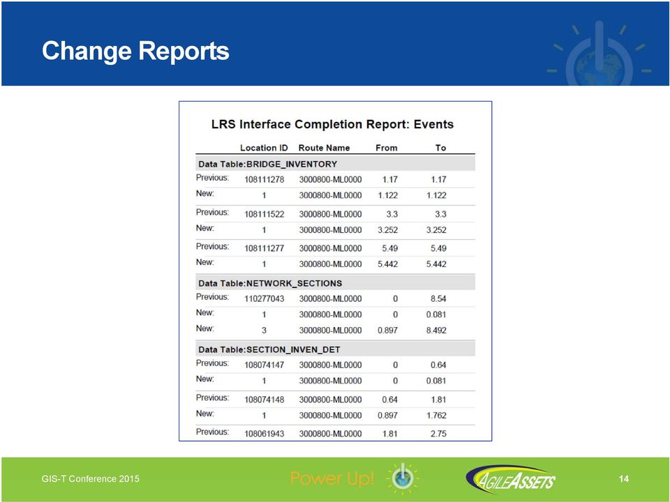
15 4. Post-processing after LRS Interface Bridge Pavement Safety Traffic Maintenance Report of changed events Automated data update for changed events Report of new route segments Automated data update for new route segments Report of retired route segments Automated data update for retired route segments Report of changed jurisdictions Automated data update for changed jurisdictions GIS-T Conference

16 4. Post-processing after LRS Interface Bridge Pavement Safety Traffic Maintenance Report of changed events Automated data update for changed events Report of new route segments Automated data update for new route segments Report of retired route segments Automated data update for retired route segments Report of changed jurisdictions Automated data update for changed jurisdictions GIS-T Conference

17 4. Post-processing after LRS Interface Bridge Pavement Safety Traffic Maintenance Report of changed events Automated data update for changed events Report of new route segments Automated data update for new route segments Report of retired route segments Automated data update for retired route segments Report of changed jurisdictions Automated data update for changed jurisdictions GIS-T Conference

18 4. Post-processing after LRS Interface Bridge Pavement Safety Traffic Maintenance Report of changed events Automated data update for changed events Report of new route segments Automated data update for new route segments Report of retired route segments Automated data update for retired route segments Report of changed jurisdictions Automated data update for changed jurisdictions GIS-T Conference

19 Review Evolution of LRS Maintenance Lessons learned implementing Roads & Highways 1. Periodic vs dynamic updates 2. LRS editing with event updates in mind 3. Include Asset Managers into the QC process 4. Post-processing the LRS Interface Contact Info: Phil Hardy - AgileAssets [email protected] GIS-T Conference

20

21 LRS Interface Methodology External System Esri Roads & Highways Bentley/Exor Various homegrown systems Integration Layer Custom for each external system Buffer Tables Allows prior review of changes LRS Gateway Common across the board AgileAssets AMS Home base for Asset events
22 LRS Editing with Assets in Mind 2 ways to do this edit Replace the entire route Do 2 realignments ~7 miles
23 LRS Editing with Assets in Mind 1) Replace the entire route Event effect: retire all events ~7 miles
24 LRS Editing with Assets in Mind 2) Do 2 realignments Event effect: retire only affected events ~7 miles
25 Involve Asset Managers in LRS QC Test Mode Option Allows business units to preview results Can preview changes to both LRS and Events Allows LRS to be reworked if necessary with no harm done GIS-T Conference
26 New Alignment Old Alignment
27 Interface to Roads & Highways GUI standard system job
28 LRS Interface Planning Make sure the 2 LRSs are in sync In terms of data In terms of LRM design Make sure your event location data is clean (i.e. it fits on the LRS) Make sure the 2 sides of the interface can fully communicate with each other
29 Configuration Steps Fill in Interface Config window (partially) Make connection (ArcCatalog - AgileAssets system) Register External Events with Rds & Hwys Create Rds & Hwys Export Network web service Create Rds & Hwys Relocate Events web services Finish filling in Interface Config window
30
31 Configuration Window
32 Interface to Roads & Highways Simplified Workflow Start Request Updated LRS Load LRS Buffer Tables Load Events to be Updated Table Request Updated Events Load Event Buffer Tables Update AMS Tables from Buffers Integration Layer LRS Gateway
33 Comparison Views Routes
34
35 Comparison Views Events
36 Comparison Views Concurrencies
37 Comparison Views LRMs
38 QC Roads & Highways R&H Analyze Data Reviewer AgileAssets Job errors may have links to ArcGIS errors System Logs (provides extra details on Job errors) Error messages in Comparison views Invalid tables
39 Interface to Roads & Highways LRS v2 is available LRS v3 is available LRS v4 is available Making edits to LRS v1 Making edits to LRS v2 Making edits to LRS v3 R&H v1 v2 v2 v3 v3 v4 Run Interface Run Interface Run Interface AgileAssets v1 Adding events to LRS v1 v2 Adding events to LRS v2 v3 Adding events to LRS v3 Import LRS v2 Import LRS v3 Import LRS v4
40 Editing Activities Create Route Extend Route Realign Route retired Reassign Route I 10 I 110 I 10 Retire Route retired 1 10 Calibration
41 Event Measure Behaviors Before Realignment Stay Put Move Snap Retire
42 Planning Make sure the 2 LRMs are in sync In terms of data In terms of LRM design LRM design needs to be based on lowest common denominator Examples: AgileAssets requires a base LRM that covers entire network R&H returns a single, concatenated route name for all LRMs Make sure the 2 sides of the interface can fully communicate with each other Make sure your event data is clean (i.e. it fits on the LRS)
An Esri White Paper July 2010 Highway Data Management in ArcGIS
 An Esri White Paper July 2010 Highway Data Management in ArcGIS Esri, 380 New York St., Redlands, CA 92373-8100 USA TEL 909-793-2853 FAX 909-793-5953 E-MAIL [email protected] WEB www.esri.com Copyright 2010
Maintenance Management and Asset Management
 Defining and Understanding the Difference Between Maintenance Management and Asset Management Dr. Simon Lewis AgileAssets, Inc. 12th AASHTO-TRB Maintenance Management Conference Annapolis Maryland, July
The World s Most Advanced Infrastructure Asset Management Software
 The World s Most Advanced Infrastructure Asset Management Software Solutions for Cities and Counties The Leading Global Provider of Integrated Infrastructure Asset Management Software Solutions Advanced
Intergraph Roadway Information Management Solution. Title Title. Title Title. A White Paper
 Intergraph Roadway Information Management Solution A White Paper Security, Government & Infrastructure, a division of Intergraph Title Title Title Title Table of Contents 1. Introduction... 1 2. Intergraph
Asset Management for MAP-21. Gary Lasham, P.E. Jonathan Pollack
 Asset Management for MAP-21 Gary Lasham, P.E. Jonathan Pollack Replaced Intermodal Surface Transportation Efficiency Act (ISTEA) MAP-21 is transforming the policy and programmatic framework for investments
Operations Management and the Integrated Manufacturing Facility
 March 2010 Page 1 and the Integrated Manufacturing Facility This white paper provides a summary of the business value for investing in software systems to automate manufacturing operations within the scope
HERS_IN. HIGHWAY ECONOMIC REQUIREMENTS SYSTEM (for) INDIANA. AASHTO Transportation Estimator Association Conference October 16, 2001
 INDIANA. AASHTO Transportation Estimator Association Conference October 16, 2001") AASHTO Transportation Estimator Association Conference October 16, 2001 HERS_IN HIGHWAY ECONOMIC REQUIREMENTS SYSTEM (for) INDIANA OVERVIEW HERS Background System Planning Tool Development HERS_IN Structure
AASHTO Transportation Estimator Association Conference October 16, 2001 HERS_IN HIGHWAY ECONOMIC REQUIREMENTS SYSTEM (for) INDIANA OVERVIEW HERS Background System Planning Tool Development HERS_IN Structure
Integrating GIS-Based Videolog and Asset Data With Commonly Used Systems Provides Major Benefits With Minimal Effort
 Integrating GIS-Based Videolog and Asset Data With Commonly Used Systems Provides Major Benefits With Minimal Effort Presented By: Debbie Burns, GIS Manager Michael Nieminen, Project Manager Introduction
Service Portfolio Management PinkVERIFY
 -11-G-001 General Criteria Does the tool use ITIL 2011 Edition process terms and align to ITIL 2011 Edition workflows and process integrations? -11-G-002 Does the tool have security controls in place to
The Indiana Experience
 Transportation Asset Management Case Studies Presented by HIGHWAY ECONOMIC REQUIREMENTS SYSTEM-STATE The Indiana Experience Aerial view of the I-65/I-75 split in Indianapolis. Photo by James Kinder. FRONT
GIS Tutorial for Marketing. Managing Sales Territories
 GIS Tutorial for Marketing Chapter 9 Managing Sales Territories Marketing scenario Northwest s Best: A new wine distributor specializing in products of Washington and Oregon vineyards Has secured exclusive
1What purpose do guard
 g u a r d F c a b A l e Q f re q u e n t l y a s k e d q u e s t i o n s 1What purpose do guard cables serve? Cross-Median Fatalities The purpose of high-tension guard cable is to prevent vehicles that,
Active Asset Management in State DOTs
 Active Asset Management in State DOTs Stuart Hudson, P.E. Charles Pilson, PhD, and Eric Perrone AgileAssets Inc. Prepared for : 9 th National Conference on Transportation Asset Management San Diego, CA
How To Improve Gis Data Quality
 An Esri White Paper July 2011 GIS Data Quality Best Practices for Water, Wastewater, and Stormwater Utilities Esri, 380 New York St., Redlands, CA 92373-8100 USA TEL 909-793-2853 FAX 909-793-5953 E-MAIL
2014 TRANSPORTATION SAFETY SUMMIT LOUISIANA STATE POLICE & LADOTD TIM INITIATIVE
 2014 TRANSPORTATION SAFETY SUMMIT LOUISIANA STATE POLICE & LADOTD TIM INITIATIVE PROJECT SUMMARY & PRESENTATION LAW ENFORCEMENT FIRE EMS TRANSPORTATION TOWING & RECOVERY COMMUNICATIONS What is Traffic
Pavement Management Implementation: Success Stories for Maryland Counties
 Pavement Management Implementation: Success Stories for Maryland Counties September 25, 2015 Aaron D. Gerber, P.E. How Does Your Organization Manage Pavement Assets? By Experience/Past Practice? By Customer
INDOT 2000-2025 Long Range Plan
 Chapter 9 INDOT 2000-2025 Long Range Plan Highway Needs Analysis Overview The statewide transportation planning process provides for the identification of highway needs through a comprehensive process
ArcPad a new tool for Asset Inventory/Management at Nevada DOT. Eric Warmath GIS Program Manager, NDOT
 ArcPad a new tool for Asset Inventory/Management at Nevada DOT Eric Warmath GIS Program Manager, NDOT Topics Historical Data Collection Methods Current Methodology Operator Safety Issues Add on Technologies
APPLICATION LAFAYETTE METROPOLITAN PLANNING ORGANIZATION (MPO) SURFACE TRANSPORTATION PROGRAM (STP) FUNDS TRANSPORTATION IMPROVEMENT PROGRAM (TIP)
 SURFACE TRANSPORTATION PROGRAM (STP) FUNDS TRANSPORTATION IMPROVEMENT PROGRAM (TIP)") APPLICATION LAFAYETTE METROPOLITAN PLANNING ORGANIZATION (MPO) SURFACE TRANSPORTATION PROGRAM (STP) FUNDS TRANSPORTATION IMPROVEMENT PROGRAM (TIP) To be considered for STP funding, a proposed project must
APPLICATION LAFAYETTE METROPOLITAN PLANNING ORGANIZATION (MPO) SURFACE TRANSPORTATION PROGRAM (STP) FUNDS TRANSPORTATION IMPROVEMENT PROGRAM (TIP) To be considered for STP funding, a proposed project must
How To Do Business With Target
 Agenda Target Overview How To Do Business With Target Amanda Alwy, Target Jason Lavik, Target Carmen Pehler, Target Partners Online Item Management Global Data Synchronization EDI and Barcodes Contact
INCOG Transportation Planning Division Spatial Data Management Workflow GIS-T 2008
 INCOG Transportation Planning Division Spatial Data Management Workflow GIS-T 2008 Kevin Tartar, GISP Transportation Geodatabase Coordinator 201 West 5th Street, Suite 600 Tulsa, Oklahoma 74103 Phone:
ArcGIS Server Implementation HIGHS and lows
 ArcGIS Server Implementation HIGHS and lows GIS-T March 2011 Eric Abrams Iowa DOT [email protected] Agenda The Problem Timeline Future Discussion/Questions The Problem - 2006 How does Iowa DOT integrate
SAP CRM RAPID DEPLOYMENT SOLUTION. Package Overview
 SAP CRM RAPID DEPLOYMENT SOLUTION Package Overview Agenda About Acorel Introduction of Rapid deployment Solution RDS for SAP CRM Overview Solution RDS - Timeline Implementation Costs RDS - Summary 2 3
Supply Chain development - a cornerstone for business success
 Supply Chain development - a cornerstone for business success Agenda 1. Supply chain considerations 2. Benefits of a developed SCM strategy 3. Competitive advantage by using a LSP 4. CRM/SCM key to business
Integrating the I-95 Vehicle Probe Project Data and Analysis Tools into the FAMPO Planning Program
 Integrating the I-95 Vehicle Probe Project Data and Analysis Tools into the FAMPO Planning Program I-95 Corridor Coalition Background The I-95 Corridor Coalition is an alliance of transportation agencies,
D E S C R T E. Evolution 2015. Global User & Partner Conference MAY 19-21 M I AMI, F L O R I D A. Program Overview. www. d escartes.
 D E S C R T E STM Evolution 2015 Global User & Partner Conference MAY 19-21 M I AMI, F L O R I D A Program Overview www. d escartes.com/ usergr o u p Global User & Partner Conference Program Overview About
IT Infrastructure Problems for Asset Management
 IT Infrastructure Problems for Asset Management W. J. Rasdorf, Ph.D., P.E., F. ASCE 1 ; J. E. Hummer, Ph.D., P.E., M. ASCE 2 ; E. A. Harris, S. M. ASCE 3 Department of Civil, Construction, and Environmental
Application of GIS in Transportation Planning: The Case of Riyadh, the Kingdom of Saudi Arabia
 Application of GIS in Transportation Planning: The Case of Riyadh, the Kingdom of Saudi Arabia Mezyad Alterkawi King Saud University, Kingdom of Saudi Arabia * Abstract This paper is intended to illustrate
Functional Requirements for a Comprehensive Transportation Location Referencing System
 Functional Requirements for a Comprehensive Transportation Location Referencing System By Teresa M. Adams Associate Professor Department of Civil and Environmental Engineering University of Wisconsin-Madison
CHAPTER 2 PAVEMENT MANAGEMENT SYSTEM
 CHAPTER 2 PAVEMENT MANAGEMENT SYSTEM 2.1. INTRODUCTION TO PAVEMENT MANAGEMENT The ability of a pavement system to serve a society is largely a function of planning. Planning is the intersection between
How To Plan A City Of Korea
 TRANSCAD MODELING AT NCTCOG: WHAT WE NOW HAVE For UT-Austin/NCTCOG Meeting January 28, 2004 AGENDA Background Modeling Environment Trip Generation And Distribution Transit Skims Mode Choice Transit And
MAP 21 themes. Strengthens America s highway and public transportation systems. Supports the Department s aggressive safety agenda
 MAP 21 themes Strengthens America s highway and public transportation systems Creates jobs and supports economic growth Supports the Department s aggressive safety agenda Simplifies and focuses the Federal
How To Manage Transportation Asset Management
 1 TRANSPORTATION ASSET MANAGEMENT THE NEW BUSINESS MODEL FOR TRANSPORTATION AGENCIES Presented at the AASHTO Subcommittee on Transportation Finance Policy Business Meeting Irvine, California June 26, 2012
Embedding Maps into Microsoft Office and Microsoft SharePoint
 Embedding Maps into Microsoft Office and Microsoft SharePoint Toronto Esri Canada User Conference Tuesday, October 16, 2012 Presented By: Heather Hainsworth [email protected] Agenda This seminar is designed
Caltrans - Asset Management Implementation. March 2015
 Caltrans - Asset Management Implementation March 2015 Asset Management Plan Definition An asset management plan is a strategic plan for managing an organization's infrastructure and other assets to deliver
How to Setup and Manage Spatial Assets with ArcGIS Online for a Mobile Workforce
 How to Setup and Manage Spatial Assets with ArcGIS Online for a Mobile Workforce W A U R I S A 2 0 1 4 Presented By Engineer Technician II Pierce County Public Works and Utilities Road Operations Division
Chapter Forty-seven. RURAL TWO-LANE/MULTILANE STATE HIGHWAYS (New Construction/Reconstruction) BUREAU OF DESIGN AND ENVIRONMENT MANUAL
 BUREAU OF DESIGN AND ENVIRONMENT MANUAL") Chapter Forty-seven RURAL TWO-LANE/MULTILANE STATE HIGHWAYS (New Construction/Reconstruction) BUREAU OF DESIGN AND ENVIRONMENT MANUAL Illinois RURAL TWO-LANE/MULTILANE STATE HIGHWAYS December 2009 2 Illinois
Chapter Forty-seven RURAL TWO-LANE/MULTILANE STATE HIGHWAYS (New Construction/Reconstruction) BUREAU OF DESIGN AND ENVIRONMENT MANUAL Illinois RURAL TWO-LANE/MULTILANE STATE HIGHWAYS December 2009 2 Illinois
Visualizing Pavement Management Data at the Project Level
 Rydholm, Luhr 1 Visualizing Pavement Management Data at the Project Level Timothy C. Rydholm WSPMS Administrator Washington State Department of Transportation PO Box 47365 Olympia, WA 98504-7365 Phone:
How To Manage A Highway Asset Management System
 Transportation Asset Management System: The Manitoba Experience................... Dan Buhler, Director Information Technology Services Manitoba Infrastructure and Transportation (MIT) Presented at HEEP
ArcGIS Pro. James Tedrick, Esri
 ArcGIS Pro James Tedrick, Esri What you already know Why ArcGIS PRO? Vision The next generation ArcGIS desktop application for the GIS community who need a clean and comprehensive user experience which
Surface Transportation Program (STP)
") Project Name: Project Sponsor: FEDERAL FUNDS PROJECT APPLICATION TRANSPORTATION IMPROVEMENT PROGRAM 2008-2013 SALT LAKE and OGDEN/ LAYTON URBAN AREAS Surface Transportation Program (STP) Urban Surface
Project Name: Project Sponsor: FEDERAL FUNDS PROJECT APPLICATION TRANSPORTATION IMPROVEMENT PROGRAM 2008-2013 SALT LAKE and OGDEN/ LAYTON URBAN AREAS Surface Transportation Program (STP) Urban Surface
Building your Server for High Availability and Disaster Recovery. Witt Mathot Danny Krouk
 Building your Server for High Availability and Disaster Recovery Witt Mathot Danny Krouk Terminology Whoa! Resiliency High Availability RTO Round Robin Business Continuity A Spectrum, Not a Switch Backup
Surface Transportation Program (STP) Projects
 Projects") Toledo Metropolitan Area Council of Governments American Reinvestment and Recovery Act (Economic Stimulus Program) Application Packet for: Surface Transportation Program (STP) Projects APPLICATIONS DUE
Toledo Metropolitan Area Council of Governments American Reinvestment and Recovery Act (Economic Stimulus Program) Application Packet for: Surface Transportation Program (STP) Projects APPLICATIONS DUE
GIS I Business Exr02 (av 9-10) - Expand Market Share (v3b, Jul 2013)
 - Expand Market Share (v3b, Jul 2013)") GIS I Business Exr02 (av 9-10) - Expand Market Share (v3b, Jul 2013) Learning Objectives: Reinforce information literacy skills Reinforce database manipulation / querying skills Reinforce joining and mapping
GIS I Business Exr02 (av 9-10) - Expand Market Share (v3b, Jul 2013) Learning Objectives: Reinforce information literacy skills Reinforce database manipulation / querying skills Reinforce joining and mapping
A GIS-Based Integrated Infrastructure Management System
 A GIS-Based Integrated Infrastructure Management System Adelino FERREIRA and Anabela DUARTE, Portugal Key words: Geographic Information System, Infrastructure management, linear referencing system, engineering
Penn State University (PSU)
") Penn State University (PSU) FAM Inventory Management Training Manual Prepared By Revision History Revision Date: March 18, 2014 Revision Number: 1 Revision # Date Collaborator Description 1.0 March 18,
Penn State University (PSU) FAM Inventory Management Training Manual Prepared By Revision History Revision Date: March 18, 2014 Revision Number: 1 Revision # Date Collaborator Description 1.0 March 18,
HAWAII TECH TALK SDN. Paul Deakin Field Systems Engineer
 HAWAII TECH TALK SDN Paul Deakin Field Systems Engineer SDN What Is It? SDN stand for Software Defined Networking SDN is a fancy term for: Using a controller to tell switches where to send packets SDN
Table of Contents 1 Configuring TallyShop for a Single-Site License... 1 2 Configuring TallyShop for a Multi-Site License... 3
 Activating Add-ons Table of Contents 1 Configuring TallyShop for a Single-Site License... 1 2 Configuring TallyShop for a Multi-Site License... 3 Tally Solutions Pvt. Ltd. i 1. Configuring Add-ons for
Goals & Objectives. Chapter 9. Transportation
 Goals & Objectives Chapter 9 Transportation Transportation MISSION STATEMENT: TO PROVIDE A TRANSPORTATION NETWORK CAPABLE OF MOVING PEOPLE AND GOODS EFFICIENTLY AND SAFELY. T he transportation system
Location Referencing for An Asset Management System A State DOT Approach
 Location Referencing for An Asset Management System A State DOT Approach Jack Stickel Alaska Department of Transportation and Public Facilities Traditional Asset Management System Maintenance Management
Data Validation Online References
 Data Validation Online References Submitted To: Program Manager GeoConnections Victoria, BC, Canada Submitted By: Jody Garnett Brent Owens Refractions Research Inc. Suite 400, 1207 Douglas Street Victoria,
Top Ten Private Cloud Risks. Potential downtime and data loss causes
 Top Ten Private Cloud Risks Potential downtime and data loss causes Introduction: Risk sources Enterprises routinely build Disaster Recovery and High Availability measures into their private cloud environments.
Truck Size, Weight and Route Regulation in Illinois. Presented to TRF Chicago Chapter By Larry Wilson, Wilson Consulting July, 2005
 Truck Size, Weight and Route Regulation in Illinois Presented to TRF Chicago Chapter By Larry Wilson, Wilson Consulting July, 2005 Outline Chicago Metropolis 2020 Freight Plan Elements of Truck Regulation
Section 11.5 TESTING AND CORRECTING ASPHALT PAVEMENT SURFACE DEFICIENCIES
 Section 11.5 TESTING AND CORRECTING ASPHALT PAVEMENT SURFACE DEFICIENCIES 11.5.1 Purpose To provide a uniform procedure for determining that the last structural layer meets the applicable straightedge
Benefits of Mobile GIS for Public Works
 Benefits of Mobile GIS for Public Works Freese and Nichols, Inc. NCAFPM 2013 Agenda General GIS Concepts Mobile GIS Overview Benefits of Mobile GIS Mobile GIS Project Examples Questions What is GIS? Geographic
Making Data Work. Florida Department of Transportation October 24, 2014
 Making Data Work Florida Department of Transportation October 24, 2014 1 2 Data, Data Everywhere. Challenges in organizing this vast amount of data into something actionable: Where to find? How to store?
Set Up a VM-Series Firewall on the Citrix SDX Server
 Set Up a VM-Series Firewall on the Citrix SDX Server Palo Alto Networks VM-Series Deployment Guide PAN-OS 6.1 Contact Information Corporate Headquarters: Palo Alto Networks 4401 Great America Parkway Santa
Informational Workshop Public Meeting Kanawha Falls Bridge Project
 Informational Workshop Public Meeting Kanawha Falls Project WV Department of Transportation Division of Highways in Cooperation with the Federal Highway Administration State Project S310-13-0.02 00 Federal
Network Analysis with Python. Deelesh Mandloi
 Deelesh Mandloi Slides and code samples from this demo theater http://esriurl.com/uc15nawpy Topics ArcGIS Network Analyst extension and concepts Network analysis using ArcGIS Online Network analysis using
Ideal Stock control Product Overview. www.idealsoftware.co.za [email protected] +27 82 806 6743
 Ideal Stock control www.idealsoftware.co.za [email protected] +27 82 806 6743 Introduction Ideal Stock Control is a comprehensive food service cost accounting software package designed to isolate
Infrastructure and Growth Leadership Advisory Group Ideas and Approaches Survey
 Infrastructure and Growth Leadership Advisory Group Ideas and Approaches Survey In its second meeting, the Infrastructure and Growth Leadership Advisory Group expanded and refined the list of approaches/ideas
GIS a Tool for Transportation Infrastructure Planning in Ghana A Case Study to the Department of Feeder Roads
 GIS a Tool for Transportation Infrastructure Planning in Ghana A Case Study to the Department of Stephen Yao FIATORNU, Ghana Key words: SUMMARY With the development of GIS technology, network transportation
GIS Solutions for Highway and Roadway Management. Average Lane Speed (mph)
") GIS Solutions for Highway and Roadway Management Average Lane Speed (mph) Collect Information from the Field with Mobile GIS Esri s mobile GIS technology allows transportation maintenance and inspection
GIS Solutions for Highway and Roadway Management Average Lane Speed (mph) Collect Information from the Field with Mobile GIS Esri s mobile GIS technology allows transportation maintenance and inspection
MOC 20467B: Designing Business Intelligence Solutions with Microsoft SQL Server 2012
 MOC 20467B: Designing Business Intelligence Solutions with Microsoft SQL Server 2012 Course Overview This course provides students with the knowledge and skills to design business intelligence solutions
Wilmington Urban Area Metropolitan Planning Organization Surface Transportation Program Direct Attributable Project Submittal Guide Fiscal Year 2016
 Wilmington Urban Area Metropolitan Planning Organization Surface Transportation Program Direct Attributable Project Submittal Guide Fiscal Year 2016 Date of Release: September 14, 2015 Pre application
CAPACITY AND LEVEL-OF-SERVICE CONCEPTS
 CHAPTER 2 CAPACITY AND LEVEL-OF-SERVICE CONCEPTS CONTENTS I. INTRODUCTION...2-1 II. CAPACITY...2-2 III. DEMAND...2-2 IV. QUALITY AND LEVELS OF SERVICE...2-2 Service Flow Rates...2-3 Performance Measures...2-3
ArcGIS Workflow Manager: An Overview
 Federal GIS Conference February 9 10, 2015 Washington, DC ArcGIS Workflow Manager: An Overview Heather Murnane & Elizabeth Wilcox Session Topics Overview Key Features Notification & Reporting Overview
IBM asset and service management solutions White paper. Asset and service management for Departments of Transportation.
 IBM asset and service management solutions White paper Asset and service management for Departments of Transportation. March 2007 Page 2 Contents 2 Executive summary 3 Introduction 4 Unifying asset management
ArcGIS for. Intelligence
 ArcGIS for ArcGIS for solutions.arcgis.com/intelligence Copyright 2015 Esri. All rights reserved. 146660 DUAL3M7/15rk Briefing Book ArcGIS for Briefing Book ArcGIS Web Application ArcGIS for Create and
http://www.esri.com/bia
 ArcGIS for Tribal Transportation Management David Gadsden Federal Account Manager [email protected] d d 1 David Gadsden GIS Background UW Geography (1995) Peace Corps Tanzania Environmental Social Science
1 Building an Identity Management Business Case. 2 Agenda. 3 Business Challenges
 1 Building an Identity Management Business Case Managing the User Lifecycle Across On-Premises and Cloud-Hosted Applications Justifying investment in identity management automation. 2 Agenda Business challenges
Automated Testing of a Fully Automated Greenfield Terminal: A Case Study
 Automated Testing of a Fully Automated Greenfield Terminal: A Case Study March 2015 Stéphane Zampelli 1 Agenda How is Automated Testing useful? Automated Testing Overview at RWG Waterside Automated Tests
Travel and Expense Management User Guide. Revised 02.04.15
 Travel and Expense Management User Guide Revised 02.04.15 2 Table of Contents Access TEM and Review Profile. 4 Submitting a Travel Authorization (TA).. 5 Intro and Login.. 5 Funding Change. 6 Itinerary..
Load Balancing Using a Co-Simulation/Optimization/Control Approach. Petros Ioannou
 Stopping Criteria Freight Transportation Network Network Data Network Simulation Models Network states Optimization: Minimum cost Route Load Balancing Using a Co-Simulation/Optimization/Control Approach
All-in-One Asset Management Tool
 APEX-RU0781 All-in-One Asset Management Tool Final Report October 2012 Submitted by Mansooreh Mollaghasemi, Ph.D. Chairman and CEO Productivity Apex, Inc 3505 Lake Lynda Drive, Suite 206 Orlando, FL 32817
Info What? Using InfoMaster to Develop a Rehabilitation and Replacement Plan
 Info What? Using InfoMaster to Develop a Rehabilitation and Replacement Plan Amanda Lei - City of San Jose Alex Palmatier - HDR 2014 HDR, Inc., all rights reserved. Background Forecasting and Budget Data
Layer 2 Networking. Overview. VLANs. Tech Note
 Layer 2 Networking Tech Note Overview PAN-OS is very flexible, allowing administrators to mix and match physical firewall interfaces amongst virtual wire, layer 2, layer 3, and tap mode configurations.