BookletChart. Head of Chesapeake Bay. (NOAA Chart 12274)
|
|
|
- Tracy Barton
- 7 years ago
- Views:
Transcription

1 BookletChart Head of Chesapeake Bay (NOAA Chart 12274) A reduced scale NOAA nautical chart for small boaters. When possible, use the full size NOAA chart for navigation. Complete, reduced scale nautical chart Print at home for free Convenient size Up to date with all Notices to Mariners United States Coast Pilot excerpts Compiled by NOAA, the nation s chartmaker. ) le sa r fo t o ( n n io it d E e m o H
2 Published by National Oceanic and Atmospheric Administration National Ocean Service Office of Coast Survey What are Nautical Charts? Nautical charts are a fundamental tool of marine navigation. They show water depths, obstructions, buoys, other aids to navigation, and much more. The information is shown in a way that promotes safe and efficient navigation. Chart carriage is mandatory on the commercial ships that carry America s commerce. They are also used on every Navy and Coast Guard ship, fishing and passenger vessels, and are widely carried by recreational boaters. What is a BookletChart? This BookletChart is made to help recreational boaters locate themselves on the water. It has been reduced in scale for convenience, but otherwise contains all the information of the full-scale nautical chart. The bar scales have also been reduced, and are accurate when used to measure distances in this BookletChart. Whenever possible, use the official, full scale NOAA nautical chart for navigation. Nautical chart sales agents are listed at: The charts and bar scales in this BookletChart have been reduced to 62% of original scale, and are printed at the new scale of 1:64,516. This BookletChart does NOT fulfill chart carriage requirements for regulated commercial vessels under Titles 33 and 44 of the Code of Federal Regulations. Notice to Mariners Correction Status This BookletChart has been updated for chart corrections published in the U.S. Coast Guard Local Notice to Mariners, the National Geospatial Intelligence Agency (formerly NIMA) Weekly Notice to Mariners, and, where applicable, the Canadian Coast Guard Notice to Mariners. Additional chart corrections have been made by NOAA in advance of their publication in a Notice to Mariners. The last Notices to Mariners applied were: Coast Guard Local Notice to Mariners: 28/05 July 12, 2005 NGA Weekly Notice to Mariners: 29/05 July 16, 2005 Canadian Coast Guard Notice to Mariners: Not Applicable [Coast Pilot 3, Chapter 15 excerpts] (192) Gunpowder River is entered through a channel marked by a light and buoys west of Spry Island Shoal; the shoal is covered 2 to 4 feet; the channel had depths of 8 feet for 2 miles; 2 to 9 feet for 4 miles; 3 feet in a channel leading to a creek below Joppatowne, with depths of 4 to 7 feet and 4 feet in the marina basin. (194) Marinas above the bridge have slips, gasoline, and marine supplies. (196) Some waters of the Aberdeen Proving Ground are closed to the public at all times. Others have a limited access during specified hours. (199) Bush River. The lower 5 miles are within Aberdeen Proving Ground constituting prohibited land areas and restricted and dangerous 2 water areas. (200) The river has depths of 7 feet to the railroad bridge 6.3 miles above the mouth, thence 5 to 6 feet for another 1.5 miles. The approach to the river and the channel are marked by buoys and a light as far as Tapler Point, and by a light on the east side 0.3 mile south of the railroad bridge, which shows a high-intensity beam down river; the lower light, off the western shore about 2.7 miles above the mouth shows highintensity beams up and down river. (204) Still Pond has depths of 9 to 11 feet and is a good anchorage during easterly winds. Churn Creek has depths of 2 feet in the entrance and deeper water inside. (205) Stillpond Creek is entered through a narrow channel; the depth was 7½ feet through the entrance. A light and buoys mark the entrance. The channel inside Stillpond Creek is marked by a daybeacon and buoys. (206) Stillpond Coast Guard Station is on the north side of the entrance to Stillpond Creek. (207) Sassafras River. The entrance is between Howell Point and Grove Point. The river is used by vessels drawing up to 12 feet. (208) The river channel has depths of 13 feet to a point 1 mile above the U.S. Route 213 bridge, thence 7 to 3 feet for 2 miles. The channel is marked as far as the highway bridge. (212) Fredericktown and Georgetown are connected by a bridge that has a clearance of 5 feet. The bridgetender monitors VHF-FM channel 16 and works on channels 13 and 68; call sign KYU-699. The speed limit is 6 miles per hour in Sassafras River 0.5 mile above and below the bridge. (213) There are facilities on both sides of the river below the bridge. Berthing, electricity, water, gasoline, diesel fuel, and marine supplies can be obtained. (215) Spesutie Narrows. A channel leads from the flats off the southern entrance to a basin at Mulberry Point; the depth was 5 feet to the basin with 2½ to 5 feet at the landings. The entrance channel is marked by buoys and lighted ranges; the inner channel is marked by daybeacons. (217) Spesutie Island and Spesutie Narrows are within Aberdeen Proving Ground constituting prohibited land areas and restricted and dangerous water areas. (219) Mariners are required to observe the speed regulation in Elk River, Back Creek, and Chesapeake and Delaware Canal. (221) The current velocity is 0.8 knot. (223) Bohemia River has depths of 7 feet or more for 4 miles to the junction of Great Bohemia Creek and Little Bohemia Creek; 6 to 4 feet for 1.5 miles in Great Bohemia Creek; 7 feet for 1 mile in Little Bohemia Creek. (224) The cove on the southwest side of Bohemia River 3 miles above the entrance has depths of 3 to 5 feet and is a small-boat anchorage. (225) The speed limit is 6 miles per hour from the highway bridge to 1 mile downstream in Bohemia River. (226) There are small-craft facilities along the north side of Bohemia River and along the south side of the river below the bridge. (229) Above Back Creek, the channel in Elk River is marked by buoys to Locust Point. Depths vary considerably, ranging from 10 feet at the south end to 1 foot off Locust Point. In 1978, a depth of 1 foot was in the channel above Locust Point. (230) Small-craft facilities are on Elk River 5 miles above Old Town Point Wharf. (235) Susquehanna River. A marked channel leads through the flats from Chesapeake Bay to Havre de Grace. A side channel leads to a basin at City Park at Havre de Grace; the depth was 12 feet. In 1990, a controlling depth of 2 feet (5½ feet at midchannel) was in the side channel and 4½ feet in the basin at City Park (240) There are berthing and repair facilities at Havre de Grace. (241) Perryville has berthing facilities above the first bridge. Gasoline and marine supplies are available. (242) Above Havre de Grace, depths of 13 feet to 50 feet are in the channel of the Susquehanna River to Port Deposit; the river is obstructed by rocks above here. (243) Garrett Island. The favored channel is west of the island; rocks, shoals, logs, and submerged pilings in this area. (244) Port Deposit. Gasoline and some supplies are available.

3

4

5

6

7
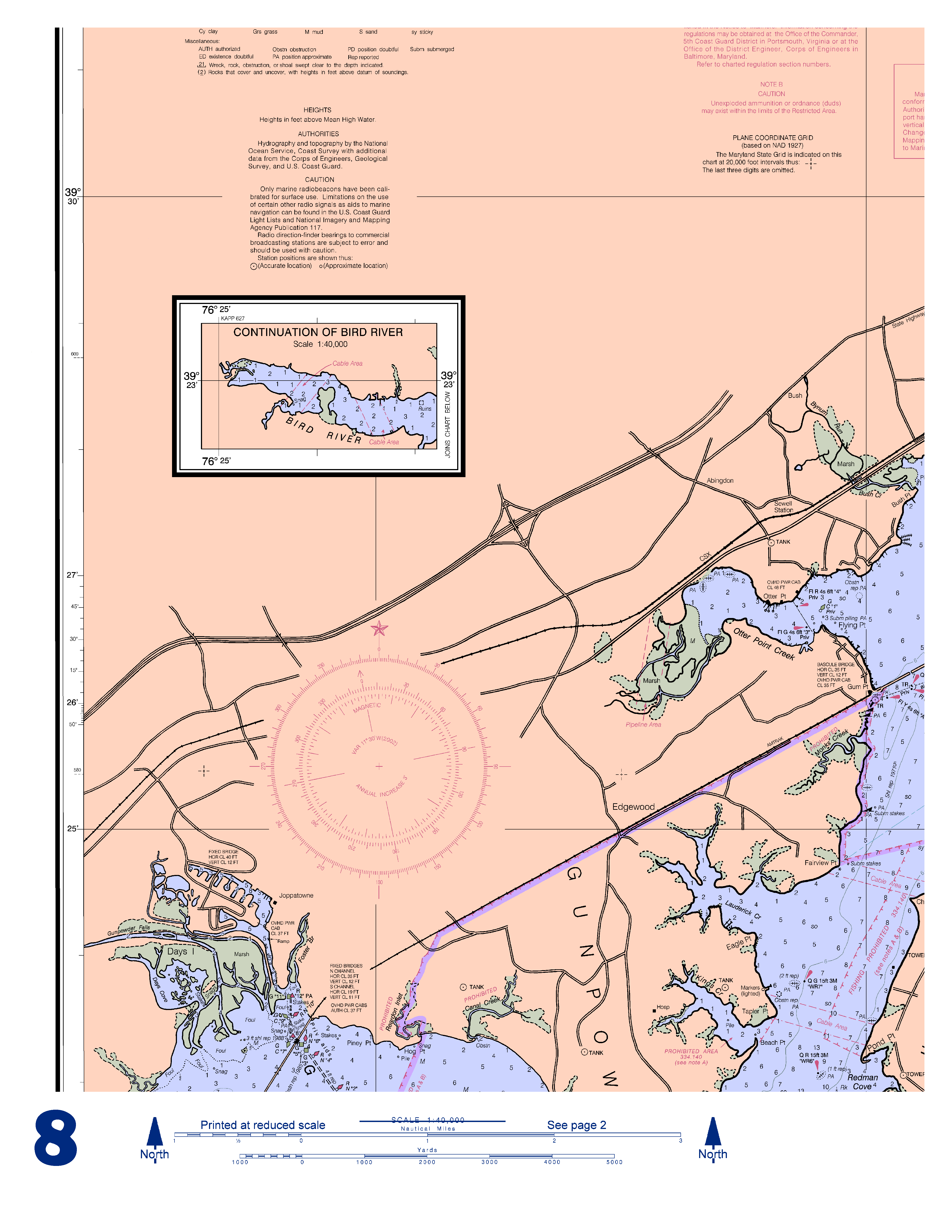
8

9

10

11

12
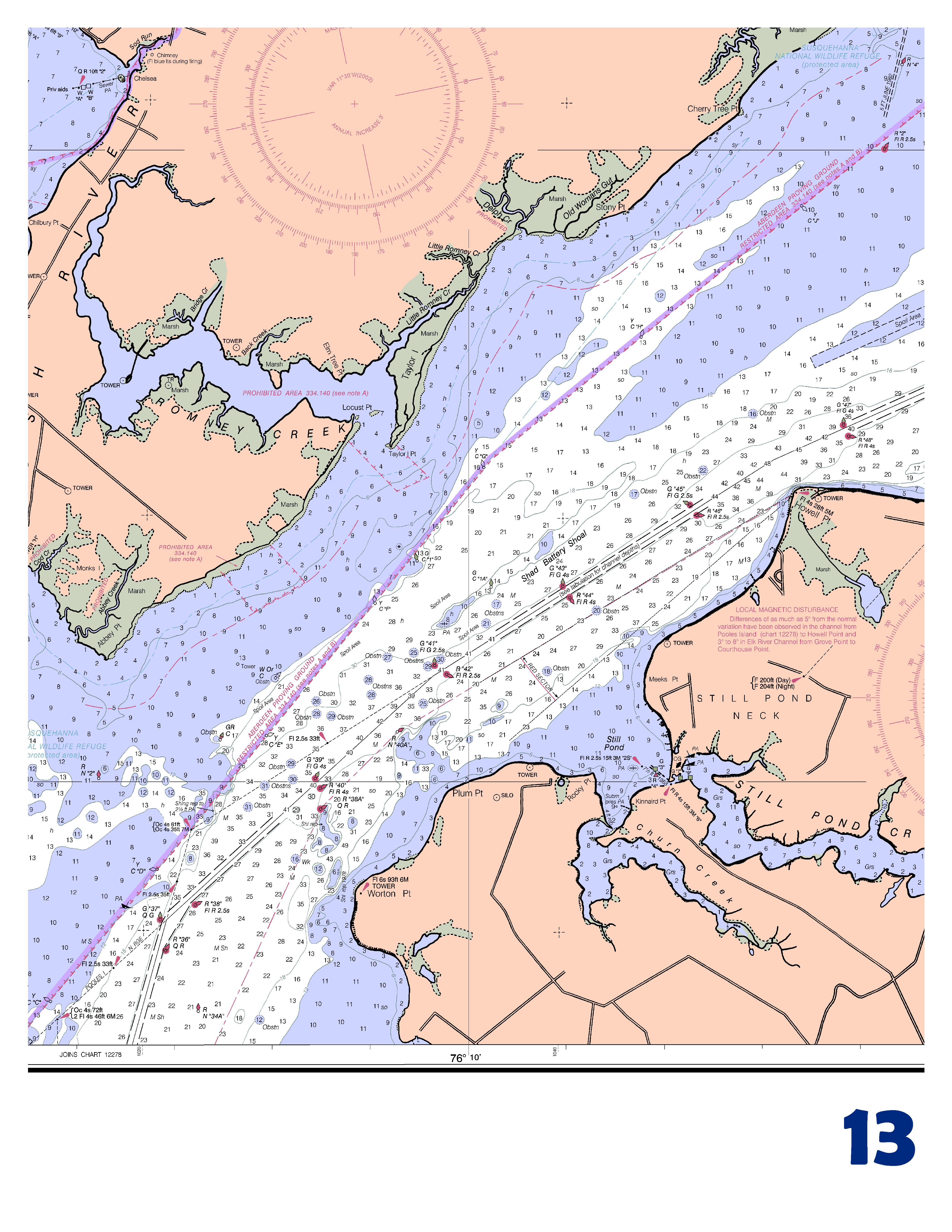
13

14

15
16 EMERGENCY INFORMATION VHF Marine Radio channels for use on the waterways: Channel 6 Intership safety communications. Channel 9 Communications between boats and ship-to-coast. Channel 13 Navigation purposes at bridges, locks, harbors. Channel 16 Emergency, distress and safety calls to Coast Guard and others, and to initiate calls to other vessels. Contact the other vessel, agree to another channel, and then switch. Channel 22 Calls between the Coast Guard and the public. Severe weather warnings, hazards to navigation and safety warnings are broadcast here. Channels 68, 69, 71, 72 & 78 Recreational boat channels. Distress Call Procedures 1. Make sure radio is on. 2. Select Channel Press/Hold the transmit button. 4. Clearly say: MAYDAY, MAYDAY, MAYDAY. 5. Also give: Vessel Name and/or Description; Position and/or Location; Nature of Emergency; Number of People on Board. 6. Release transmit button. 7. Wait for 10 seconds If no response Repeat MAYDAY Call. HAVE ALL PERSONS PUT ON LIFE JACKETS!! Mobile Phones Call 911 for water rescue. Coast Guard Search & Rescue / Coast Guard Annapolis Coast Guard Little Creek /9372 Coast Guard Stillpond Maryland Natural Resources Police NOAA Weather Radio MHz, MHz, MHz, MHz, MHz, MHz, MHz. Getting and Giving Help Signal other boaters using visual distress signals (flares, orange flag, lights, arm signals); whistles; horns; and on your VHF radio. You are required by law to help boaters in trouble. Respond to distress signals, but do not endanger yourself. NOAA CHARTING PUBLICATIONS Official NOAA Nautical Charts NOAA surveys and charts the national and territorial waters of the U.S, including the Great Lakes, producing over 1,000 traditional nautical charts covering 3.4 million square nautical miles. Carriage of official NOAA charts is mandatory on the commercial ships that carry our commerce. They are used on every Navy and Coast Guard ship, fishing and passenger vessels, and are widely carried by recreational boaters. NOAA charts are available from official chart agents listed at: Official Electronic Navigational Charts (ENCs) ENCs are digital files of each chart s features and their attributes for use in computer-based navigation systems. ENCs comply with standards of the International Hydrographic Organization. ENCs and their updates are available for free from NOAA at: Official Raster Navigational Charts (RNCs) RNCs are georeferenced digital pictures of NOAA s charts that are suitable for use in computer-based navigation systems. RNCs comply with standards of the International Hydrographic Organization. RNCs and their updates are available for free from NOAA at: Official BookletCharts - BookletCharts are reduced scale NOAA charts printed in page-sized pieces. The home edition can be downloaded from NOAA for free and printed. The professional edition, containing additional boating, safety, and educational edition is available for NOAA chart agents or over the Internet. Official PocketCharts PocketCharts are for beginning recreational boaters to use for planning and locating, but not for real navigation. Measuring a convenient 13 by 19, they have a 1/3 scale chart on one side, and safety, boating, and educational information on the reverse. They can be purchased at retail outlets and on the Internet. Official U.S. Coast Pilot The Coast Pilots are 9 text volumes containing information important to navigators such as channel descriptions, port facilities, anchorages, bridge and cable clearances, currents, prominent features, weather, dangers, and Federal Regulations. They supplement the charts and are available from official NOAA chart agents or downloaded for free at: Official Print-on-Demand Nautical Charts These full-scale NOAA charts are updated each week by NOAA for all Notice to Mariner corrections. They have additional information added in the margin to supplement the chart. Print on Demand charts meet all federal chart carriage regulations for charts and updating. Produced under a public/private partnership between NOAA and OceanGrafix, LLC, suppliers of these premium charts are listed at Official Chart No. 1, Nautical Chart Symbols This reference publication depicts basic chart elements and explains nautical chart symbols and abbreviations. Download it for free at: Coast Survey Navigation Managers These ambassadors to the maritime community maintain a regional presence for NOAA and help identify the challenges facing marine transportation and boating. They are listed at Internet sites: NOAA, the Nation s Chartmaker
BookletChart. San Francisco Bay Southern Part NOAA Chart 18651. A reduced-scale NOAA nautical chart for small boaters
 BookletChart San Francisco Bay Southern Part NOAA Chart 18651 A reduced-scale NOAA nautical chart for small boaters When possible, use the full-size NOAA chart for navigation. Included Area Published by
How To Navigate The Ocean In The Pacific Coastline
 BookletChart El Segundo and Approaches NOAA Chart 18748 A reduced-scale NOAA nautical chart for small boaters When possible, use the full-size NOAA chart for navigation. Published by the National Oceanic
SECTION II CORRECTIONS TO C. G. LIGHT LIST, VOLUME I ATLANTIC COAST,
 CORRECTIONS TO C. G. LIGHT LIST, VOLUME I ATLANTIC COAST, 2013 625 15980 Narragansett-Buzzards Bay Approach Lighted Whistle Buoy A 15495 - Daybeacon 2 41-27-33.93N 70-35-25.46W 15980 625 Narragansett-Buzzards
NEW ZEALAND CHARTING AND NOTICES TO MARINERS
 General Information 1. In accordance with agreements between New Zealand (NZ), Australia (AU) and the British Admiralty (BA) for reducing duplication in charting activities, New Zealand has a defined Charting
A Mariner s Guide to Marine Weather Services Great Lakes
 A Mariner s Guide to Marine Weather Services Great Lakes U.S. DEPARTMENT OF COMMERCE National Oceanic and Atmospheric Administration National Weather Service NOAA PA 98053 Introduction Few people are affected
Introduction to AIS White Paper
 Introduction to AIS White Paper 1. Background AIS (Automatic Identification System) is the mariner s most significant development in navigation safety since the introduction of radar. The system was originally
AIS Overview. Evans Starzinger
 AIS Overview by Evans Starzinger Background AIS (Automatic Identification System) is a VHF radio system which automatically communicates vessel information (vessel identity, position, speed, etc) between
WATERWAYS in Finland
 WATERWAYS in Finland The efficient and economical running of Finland s vital international transport demands a comprehensive and safe network of fairways. The mission of the Finnish Maritime Administration
Passenger Terminal Amsterdam
 Fact sheet large cruise ships to Passenger Terminal Amsterdam Port of Amsterdam Amsterdam-IJmond Pilot Organization 2009 Version: November 6 th 2009 This fact sheet provides information on the passage
IHO Commission on the Promulgation of Radio Navigational Warning (CPRNW) International Hydrographic Bureau, Monaco
 International Hydrographic Bureau, Monaco") IHO Commission on the Promulgation of Radio Navigational Warning (CPRNW) CPRNW9-3.2.1-V International Hydrographic Bureau, Monaco Origin: Brazil MSI Self Assessment - NAVAREA V Submitted by: Brazil 1.
IHO Commission on the Promulgation of Radio Navigational Warning (CPRNW) CPRNW9-3.2.1-V International Hydrographic Bureau, Monaco Origin: Brazil MSI Self Assessment - NAVAREA V Submitted by: Brazil 1.
Harbourmaster s Office Operation of Emergency Response Vessels within the Auckland Region. Navigation Safety Operating Requirements 2014
 Harbourmaster s Office Operation of Emergency Response Vessels within the Auckland Region Navigation Safety Operating Requirements 2014 Auckland Council Harbourmaster s Office Operation of Emergency Response
AIS (Automatic Identification System)
") AIS (Automatic Identification System) AIS are the one of the most important aids to navigation that you can have add to your navigations system. It is an excellent tool for collision avoidance. In the
AIS (Automatic Identification System) AIS are the one of the most important aids to navigation that you can have add to your navigations system. It is an excellent tool for collision avoidance. In the
United States Coast Guard Auxiliary Telecommunications Workshop. USCG Auxillary Communications 1
 United States Coast Guard Auxiliary Telecommunications Workshop USCG Auxillary Communications 1 United States Coast Guard The lead military agency of the Department of Homeland Security (not DOD) A multi-mission
 Enclosure (1) to NVIC 01-16 Use of official electronic charts, electronic charting systems and electronic publications This guidance applies to vessels subject to U.S. chart (or map) and publication carriage
GUIDELINES AND CRITERIA FOR VESSEL TRAFFIC SERVICES ON INLAND WATERWAYS (VTS Guidelines 2006)
") GUIDELINES AND CRITERIA FOR VESSEL TRAFFIC SERVICES ON INLAND WATERWAYS (VTS Guidelines 2006) 1. INTRODUCTION 1.1 These Guidelines are compatible with SOLAS regulation V/8-2 and IMO Assembly Resolution
GUIDELINES AND CRITERIA FOR VESSEL TRAFFIC SERVICES ON INLAND WATERWAYS (VTS Guidelines 2006) 1. INTRODUCTION 1.1 These Guidelines are compatible with SOLAS regulation V/8-2 and IMO Assembly Resolution
GUIDELINES ON THE DESIGN AND USE OF PORTABLE PILOT UNITS
 IMPA 2009 1 GUIDELINES ON THE DESIGN AND USE OF PORTABLE PILOT UNITS Prepared by IMPA With Technical Input from CIRM IMPA 2009 2 GUIDELINES ON THE DESIGN AND USE OF PORTABLE PILOT UNITS FOREWORD With the
Congratulations and Welcome USCG Flotilla 4 76, 5NR
 Congratulations and Welcome USCG Flotilla 4 76, 5NR The United States Coast Guard Auxiliary The civilian volunteer arm of the United States Coast Guard Penn s Landing Philadelphia Safe Boating Education
U.S. Coast Guard. America s Maritime Guardian
 U.S. Coast Guard America s Maritime Guardian Nov. 2009 A few armed vessels, judiciously stationed at the entrances of our ports, might at a small expense be made useful sentinels of the laws. Alexander
The Nationwide Automatic Identification System Newsletter Issue #1 3 rd Quarter FY 2007
 June 2007 Issue 1 The Nationwide Automatic Identification System Newsletter Issue #1 3 rd Quarter FY 2007 W elcome to the first issue of The Guardian, a quarterly newsletter issued by the Nationwide Automatic
Hellesylt. PORT Contact on arrival (detail name): VHF channel: 13/16 PFSO on duty Telephone: + 47 99531717 Notice required:
: VHF channel: 13/16 PFSO on duty Telephone: + 47 99531717 Notice required:") NAME OF PORT Region/City/Port : Geirangerfjord Cruise Port Internet Web Site Official Port Address: 6216 Geiranger Hellesylt www.stranda-hamnevesen.no GEIRANGERFJORD CRUISE PORT IMO registered Port Facilities
NAME OF PORT Region/City/Port : Geirangerfjord Cruise Port Internet Web Site Official Port Address: 6216 Geiranger Hellesylt www.stranda-hamnevesen.no GEIRANGERFJORD CRUISE PORT IMO registered Port Facilities
CONCEPT FOR ACTIVITY 1: DYNAMIC & PROACTIVE ROUTES OR GREEN-ROUTES
 TEN-T PROJECT NO: 2010-EU-21109-S CONCEPT FOR ACTIVITY 1: DYNAMIC & PROACTIVE ROUTES OR GREEN-ROUTES January 2012 TABLE OF CONTENTS 1 INTRODUCTION... 3 1.1 Scope and purpose... 3 1.2 Objectives and expected
AYAK GUIDE ISLAND STATE PARKS. NEW YORK STATE George E. Pataki, Governor
 AYAK & C KAYAK AYAK & CANOE GUIDE TO LONG ISLAND STATE PARKS NEW YORK STATE George E. Pataki, Governor NEW YORK STATE OFFICE OF PARKS, RECREATION AND HISTORIC PRESERVATION Bernadette Castro, Commissioner
International Maritime Pilots Assoication Association Internationale des Pilotes Maritimes Asociascisn Internacional de Practicos Maritime-portuarios
 International Maritime Pilots Assoication Association Internationale des Pilotes Maritimes Asociascisn Internacional de Practicos Maritime-portuarios INTERNATIONAL MARITIME ORGANIZATION ORGANISATION MARITIME
HARBOR INFRASTRUCTURE INVENTORIES Port Austin Harbor, Michigan
 HARBOR INFRASTRUCTURE INVENTORIES Port Austin Harbor, Michigan Harbor Location: Port Austin Harbor is located at the tip of the thumb of Michigan, about 80 miles northeast of Saginaw, MI Authority: Rivers
World Vessel Traffic Services Guide - Australia - Melbourne
 World Vessel Traffic Services Guide - Australia - Melbourne VHF Procedures Port of Melbourne VTS Area is divided into two Sectors. Sector 1: Lonsdale VTS (LVTS) Located at: POINT LONSDALE SIGNAL STATION
Hellesylt. PORT Contact on arrival (detail name): VHF channel: 13/16 PFSO on duty Telephone: + 47 91784699 Notice required:
: VHF channel: 13/16 PFSO on duty Telephone: + 47 91784699 Notice required:") NAME OF PORT Region/City/Port : Geirangerfjord Cruise Port Internet Web Site Official Port Address: 6216 Geiranger Hellesylt www.stranda-hamnevesen.no GEIRANGERFJORD CRUISE PORT IMO registered Port Facilities
NAME OF PORT Region/City/Port : Geirangerfjord Cruise Port Internet Web Site Official Port Address: 6216 Geiranger Hellesylt www.stranda-hamnevesen.no GEIRANGERFJORD CRUISE PORT IMO registered Port Facilities
World Vessel Traffic Services Guide - United Kingdom - Port of London
 World Vessel Traffic Services Guide - United Kingdom - Port of London Approaches The Port of London is normally approached using one of three channels. The main Deep Water route is from the North East
KOTKA VTS MASTER'S GUIDE
 1 (5) KOTKA VTS MASTER'S GUIDE Vessel Traffic Services The provisions on vessel traffic services are laid down in the Vessel Traffic Service Act 623/2005 and in the Government Decree on Vessel Traffic
Code of conduct Safe on-water conduct on the Brisbane River
 Code of conduct Safe on-water conduct on the Brisbane River Introduction The safe operation of passive craft on Queensland s waterways is a priority for state and local government authorities, commercial
London Array. Operations and Maintenance
 London Array londonarray.com London Array Operations & Maintenance Base Port of Ramsgate Military Road Ramsgate CT11 9LG Registered in England and Wales No 04344423 Operations and Maintenance 1 2 Operations
RESEARCH. 2010 Massachusetts Recreational Boater Survey. Project Summary
 Coastal and Marine Spatial Planning RESEARCH Project Summary 2010 Massachusetts Recreational Boater Survey The 2010 Massachusetts Recreational Boater Survey gathered spatial and economic data relating
GOFREP Master s Guide
 VEETEEDE AMET ESTONIAN MARITIME ADMINISTRATION 27 December 2010 GOFREP Master s Guide 2 (8) Contents 1 GOFREP IN GENERAL... 3 1.1 Categories of ships required to participate... 3 1.2 Information provided...
THESE INSTRUCTIONS ARE INTENDED FOR MARINERS CARRYING OUT THE IHO ENC/ECDIS DATA PRESENTATION AND PERFORMANCE CHECKS
 THESE INSTRUCTIONS ARE INTENDED FOR MARINERS CARRYING OUT THE IHO ENC/ECDIS DATA PRESENTATION AND PERFORMANCE CHECKS The checks and the accompanying dataset are not intended for, and are not suitable to
PART C SECTION 7 SUBSECTION 7B
 National Standard for Commercial Vessels PART C DESIGN AND CONSTRUCTION SECTION 7 EQUIPMENT SUBSECTION 7B COMMUNICATIONS EQUIPMENT Part C Section 7 Subsection 7B Communications Equipment National Standard
An exactearth Technical White Paper April 2015. Satellite AIS
 An exactearth Technical White Paper April 2015 Satellite AIS Executive Summary exactearth Ltd (www.exactearth.com) is a private data services company delivering global locationbased maritime vessel tracking
U. S. Coast Guard Auxiliary
 U. S. Coast Guard Auxiliary Auxiliary Aids to Navigation (ATON) Verifier Performance Qualification Standard [This page intentionally left blank] Commandant United States Coast Guard 2100 Second ST SW STOP
Safe Navigation Support System based on e-navigation Concept
 Safe Navigation Support System based on e-navigation Concept Jaeyong Oh Senior Research Scientist Korea Research Institute of Ships & Ocean Engineering (KRISO) [KRISO Ship Handling Simulator] Contents
CODES OF CONDUCT FOR VESSELS AND CRAFT USING THE CATTEWATER
 PORT OF PLYMOUTH CATTEWATER HARBOUR COMMISSIONERS 2 The Barbican, Plymouth, PL1 2LR Tel: 01752 665934 Fax: 01752 253624 e-mail: info@plymouthport.org.uk PLYMOUTH PILOTAGE SERVICE 2 The Barbican, Plymouth,
DEPARTMENT OF MARINE SERVICES AND MERCHANT SHIPPING (ADOMS) Boatmaster s Licenses
 Boatmaster s Licenses") CIRCULAR Local 2013-001 DEPARTMENT OF MARINE SERVICES AND MERCHANT SHIPPING (ADOMS) Boatmaster s Licenses Ref SCV Code. Companies operating SCV certificated vessels under the flag of Antigua and Barbuda.
CIRCULAR Local 2013-001 DEPARTMENT OF MARINE SERVICES AND MERCHANT SHIPPING (ADOMS) Boatmaster s Licenses Ref SCV Code. Companies operating SCV certificated vessels under the flag of Antigua and Barbuda.
A Short Course on Nautical Charts and Basic Plotting for the Recreational Boater
 A Short Course on Nautical Charts and Basic Plotting for the Recreational Boater Gary C. Kessler gck@garykessler.net http://www.garykessler.net/scuba Version 3.2 (1/1/2015) Gary C. Kessler, 2015 Table
Electronic Chart Systems the portable approach
 Http://www.pcmaritime.co.uk Electronic Chart Systems the portable approach Paper given at the Safety at Sea ECDIS Conference by Kay Faulkner of PC Maritime Rotterdam, September 2001 http://www.pcmaritime.co.uk
e-navigation and Geospatial Intelligence for Maritime Operations; Developing a Strategic Vision Digital Ship Athens 2014
 e-navigation and Geospatial Intelligence for Maritime Operations; Developing a Strategic Vision Digital Ship Athens 2014 Michael Rambaut for John Erik Hagen, Regional Director NCA Coordinator of IMO Correspondence
ORDINANCE NO.: 2008-01
 ORDINANCE NO.: 2008-01 AN ORDINANCE OF THE BOARD OF HERNANDO COUNTY COMMISSIONERS CREATING A SECfION OF THE HERNANDO COUNTY CODE RELATING TO THE MOORING OR DOCKING OF COMMERCIAL VESSELS AS DEFINED; PROVIDING
Jacksonville Port Authority: Fire and Rescue Marine Fire Station #40, Jacksonville, Florida
 Draft Tiered Site-Specific Environmental Assessment Jacksonville Port Authority: Fire and Rescue Marine Fire Station #40, Jacksonville, Florida Port Security Grant Program Project # 2008-GB-T8-K019 November
Marine Order 21 (Safety of navigation and emergency procedures) 2012
 2012") Marine Order 21 (Safety of navigation and emergency procedures) 2012 (AISR modification compilation) in effect under the Navigation Act 2012 This is a compilation of Marine Order 21 (Safety of navigation
Marine Order 21 (Safety of navigation and emergency procedures) 2012 (AISR modification compilation) in effect under the Navigation Act 2012 This is a compilation of Marine Order 21 (Safety of navigation
Section 9315. Operations Section Organizational Guidance
 Section 9315 Operations Section Organizational Guidance T able of Contents Section Page 9315 Operations Section Organizational Guidance... 9315-1 9315.1 Minor Inland Spill Scenario... 9315-1 9315.2 Minor
Southwick Conservation Commission
 1.0 Jurisdiction 1.1 The (Town) annual permitting program is authorized pursuant to 310 CMR 9.07(3) and the DEP letter to the dated January 13, 2010. In the event of any discrepancy between these guidelines
PORT OF SAN FRANCISCO STRATEGIC PLAN. To increase the volume of cargo shipping. To efficiently manage and improve all Port property.
 PORT OF SAN FRANCISCO STRATEGIC PLAN Mission: Goals: The Port of San Francisco is a public enterprise committed to promoting a balance of maritime, recreational, industrial, transportation, public access
REGULATION on the Maritime Traffic Service and vessel traffic monitoring and information system.
 REGULATION on the Maritime Traffic Service and vessel traffic monitoring and information system. CHAPTER I General provisions Article 1 Central administration, purpose and role The Minister of Transport
Mandatum Life Helsinki-Tallinna Race 2013 SAILING INSTRUCTIONS
 1. RULES 1.1. Governing rules and definitions The race will be governed by the rules as defined in the Racing Rules of Sailing 2013-2016 (RRS) including the FinLYS Rule with the exceptions mentioned in
Piers, Wharves & Docks
 Piers, Wharves & Docks Exposures and Concerns By: Christopher L. Pesce May 10, 2011 Piers, Wharves & Docks Statistics Why underwriters love to write docks Estimated industry losses for 2010: $30,000,000
Annex IV of MARPOL 73/78. Regulations for the Prevention of Pollution by Sewage from Ships
 Annex IV of MARPOL 73/78 Regulations for the Prevention of Pollution by Sewage from Ships Annex IV of MARPOL 73/78* Regulations for the Prevention of Pollution by Sewage from Ships Regulation 1 Definitions
Safety Guidance For Small Boat Passage of The Severn Estuary
 Safety Guidance For Small Boat Passage of The Severn Estuary These Guidance Notes have been produced in consultation with the following organisations: Maritime and Coastguard Agency Inland Waterways Association
1.1 The primary function of the ECDIS is to contribute to safe navigation.
 IMO RESOLUTION A.817 (19) PERFORMANCE STANDARDS FOR ELECTRONIC CHART DISPLAY AND INFORMATION SYSTEMS (ECDIS) Note: The IMO Performance Standards for ECDIS are reproduced in this publication for convenience,
The San Francisco Physical Oceanographic Real-Time System
 The San Francisco Physical Oceanographic Real-Time System EXECUTIVE SUMMARY The San Francisco Physical Oceanographic Real-Time System (PORTS) is a decision support tool that improves the safety and efficiency
Backcountry Avalanche Rescue Reference
 1 Backcountry Avalanche Rescue Reference This document is part of Decision Making in Avalanche Terrain: a fieldbook for winter backcountry users by Pascal Haegeli, Roger Atkins and Karl Klassen and provides
DAY SKIPPER AND LOCAL WATERS SKIPPER PRACTICAL AND ORAL GENERAL KNOWLEDGE QUESTIONS
 DAY SKIPPER AND LOCAL WATERS SKIPPER PRACTICAL AND ORAL GENERAL KNOWLEDGE QUESTIONS (Updated 22 August 2012) This list has been devised to give candidates a feel for the range of questions that could be
406 and 121.5 for Search and Rescue
 406 and 121.5 for Search and Rescue Understanding new and old Search and Rescue frequencies. European Office: Ahventie 4a7 02170 ESPOO Finland Americas Office: 150 S. Adkins Way, Suite 100 Meridian, ID
CHARTER CRAFT PROPOSAL
 MARINER MARINE INSURANCE Building 6, Eastside Office Park, 15 Accent Drive, East Tamaki Auckland, New Zealand, PO Box 204 362, Highbrook, Auckland 2161 Phone 09 250 6005, Fax 09 250 6001, Freephone 0800
The Icelandic Coast Guard. Always Prepared
 The Icelandic Coast Guard Always Prepared The Icelandic Coast Guard The Icelandic Coast Guard (ICG) has recently undergone considerable changes and renewals. As a result of extensive strategic work, the
New or Prospective Member s Guide to Useful information about Raleigh Sail and Power Squadron
 New or Prospective Member s Guide to Useful information about Raleigh Sail and Power Squadron By P/C Ed Deyo, SN And Bunie Deyo, SN 1 New or Prospective Member Guide to Information about RSPS/USPS United
Marine Guide for Ship Masters Contents
 Marine Guide for Ship Masters Contents Marine Guide for Ship Masters... 1 Port Operating Company... 2 Harbour Authority... 2 Location... 2 Pilotage... 2 Pilot Boat... 3 Pilot Ladder... 3 Pilots and Tugs
About the Port. Created as an act of state legislation 1962. Five member cities. Coronado. San Diego. Coronado. National City.
 Port of San Diego About the Port Created as an act of state legislation 1962 Coronado San Diego National City Chula Vista Five member cities Chula Vista Coronado Imperial Beach National City San Diego
Curriculum for the Degree of. Bachelor of Science. Nautical Science
 Curriculum for the Degree of Bachelor of Science In Nautical Science 1 1.Name :Bachelor of Science ( Nautical Science ) Abbreviation : B.Sc.( Nautical Science ) 2.Program of Study The Bachelor of Nautical
Marine Training Courses available from B & M Marine Services
 Richard Gray Operations Manager & Senior Trainer Birmingham & Midland Marine Services Birmingham & Midland Marine Training Birmingham & Midland Canal Carrying Company Bridgtown Cannock Staffordshire WS11
MARINE ACCIDENT REPORT DIVISION FOR INVESTIGATION OF MARITIME ACCIDENTS. R U D O K O P & A T L A N T I C C o l l i s i o n o n 2 1 M a y 2 0 0 8
 MARINE ACCIDENT REPORT DIVISION FOR INVESTIGATION OF MARITIME ACCIDENTS R U D O K O P & A T L A N T I C C o l l i s i o n o n 2 1 M a y 2 0 0 8 Report from the Division for Investigation of Maritime Accidents
The role of AIS for small ships monitoring
 The role of AIS for small ships monitoring Report February, 2007 THE ROLE OF AIS FOR SMALL SHIPS MONITORING Marek Dziewicki, Maritime Office Gdynia Department of ATON Technique and Radionavigation Systems
Partnering with the Community and Finding Volunteers
 Partnering with the Community and Finding Volunteers By Luc Ghysels By Luc Ghysels Chairman Liaison Committee and member of Steering Committee Aalborg. The Tall Ships Races 2010 Aalborg Contents 0. Introduction
Canals in Ocean City, Maryland. Terence J. McGean, PE City Engineer
 Canals in Ocean City, Maryland Terence J. McGean, PE City Engineer Background 64 canals in Ocean City Longest is approximately 4,400 lf Most created in the 60 s and early 70 s Bulkheads built in wetlands
Competency Certification
 Sheet 1 of 5 Issue no. 4 1. SCOPE All small power-driven vessel owners requiring a sea-going competency certification. 2. CERTIFICATE SAMSA Small Power-driven Vessel Certificate of Competence (ocean-going,
Integration of LIDAR Data in CARIS HIPS for NOAA Charting Carol McKenzie *, Bill Gilmour, Lieutenant Edward J. Van Den Ameele, Mark Sinclair
 Integration of LIDAR Data in CARIS HIPS for NOAA Charting Carol McKenzie *, Bill Gilmour, Lieutenant Edward J. Van Den Ameele, Mark Sinclair * Carol McKenzie, Data Center Supervisor, Thales GeoSolutions
Coast Guard Training Center Yorktown, VA. August 2011. Location: Container Inspection Training and Assistance Team, Oklahoma City, OK.
 AMERICAN COUNCIL ON EDUCATION MILITARY PROGRAMS EVALUATION Coast Guard Training Center Yorktown, VA August 2011 CG-0802-0021 CONTAINER INSPECTION Course Number: 500848. Location: Container Inspection Training
Gulf Intracoastal Waterway
 TEXAS DEPARTMENT OF TRANSPORTATION Gulf Intracoastal Waterway Photo by TexasGulfCoastOnline.com Gulf Intracoastal Waterway in Texas Figure 1 - Texas GIWW Executive Summary The Texas Department of Transportation
Real-time Risk Assessment for Aids to Navigation Using Fuzzy-FSA on Three-Dimensional Simulation System
 http://www.transnav.eu the International Journal on Marine Navigation and Safety of Sea Transportation Volume 8 Number 2 June 2014 DOI: 10.12716/1001.08.02.04 Real-time Risk Assessment for Aids to Navigation
RYA Guide to the River Medina
 RYA Guide to the River Medina Past the hustle and bustle of Cowes on the Isle of Wight, the upper reaches of the Medina River often go unexplored. But it offers with great waterside pubs, a clench of interesting
DISTRESS SIGNALS AND EMERGENCY FREQUENCIES
 DISTRESS SIGNALS AND EMERGENCY FREQUENCIES 121.5 MHz 121.5 MHz Emergency Position Indicating Radio Beacon, or EPIRB (marine type) beacons can no longer be manufactured or sold in the U.S. By 2005 certain
Navy Inactive Ships Program
 EX-ARTHUR W. RADFORD (DD 968) Frequently Asked Questions STATUS OF THE SHIP AND PROJECT SUMMARY Q. What is the current status of ex-arthur W. RADFORD? A. Ex-ARTHUR W. RADFORD was decommissioned on March
NCYC EMERGENCY MANAGEMENT PLAN
 NCYC EMERGENCY MANAGEMENT PLAN Note: This document must be carried on board all participating yachts. It is the responsibility of each yacht's master and all crew to be conversant with this Emergency Management
Australian Maritime Safety Authority. Aviation rescue
 Australian Maritime Safety Authority Aviation search and rescue Rescue Coordination Centre Australia Rescue Coordination Centre Australia (RCC Australia) is the national aviation and maritime search and
Marine Safety and Pollution Prevention Laws and Enforcement Authorities
 A rather large number of existing federal, state and local laws, regulations and ordinances affect the LA/LB Harbor area. The Committee does not have the resources to systematically review them, but has
Statistical Summary Marine Occurrences 2013
 Statistical Summary Marine Occurrences 2013 Foreword This document provides Canadians with an annual summary of selected maritime safety data. It covers commercial vessels, which include all vessels registered
South African Maritime Safety Authority
 South African Maritime Safety Authority Marine Notice No. 12 of 2008 The Merchant Shipping (Maritime Security) Regulations, 2004 TO MASTERS AND OPERATORS OF INTERNATIONALLY TRADING SHIPS BOUND FOR SOUTH
Women who are Moving Ohio into a Prosperous New World. Ohio s Maritime Vision
 Women who are Moving Ohio into a Prosperous New World Ohio s Maritime Vision Presented by: Rose Ann DeLeón Director of Government Relations and Federal Affairs Cleveland-Cuyahoga County Port Authority
PORT INFORMATION GUIDE PRIMORSK JUNE 2010
 1 PORT INFORMATION GUIDE PRIMORSK JUNE 2010 2 INITIATED BY IN ASSOCIATION WITH SUPPORTED BY 3 GENERAL INTRODUCTION This book has been written for Masters of seagoing vessels, shipping lines, publishers
COOK STRAIT SUBMARINE CABLE PROTECTION ZONE
 COOK STRAIT SUBMARINE CABLE PROTECTION ZONE An information brochure on the Submarine Cable Protection Zone across Cook Strait and how it affects mariners, fishers, divers and the public. February 2011
Law of Ukraine on the exclusive (marine) economic zone of 16 May 1995
 economic zone of 16 May 1995") Page 1 Law of Ukraine on the exclusive (marine) economic zone of 16 May 1995 Taking into consideration the relevant provisions of the 1982 United Nations Convention on the Law of the Sea, Ukraine hereby
Page 1 Law of Ukraine on the exclusive (marine) economic zone of 16 May 1995 Taking into consideration the relevant provisions of the 1982 United Nations Convention on the Law of the Sea, Ukraine hereby
Guidance on vessel traffic services (VTS) in Danish waters
 in Danish waters") Translation. Only the Danish document has legal validity. Guidance no. 9680 of 16 December 2010 issued by the Danish Maritime Authority Guidance on vessel traffic services (VTS) in Danish waters Purpose
Translation. Only the Danish document has legal validity. Guidance no. 9680 of 16 December 2010 issued by the Danish Maritime Authority Guidance on vessel traffic services (VTS) in Danish waters Purpose
(e) Harbor By-law - Article IX of the General By-laws.
 Harbor By-law - Article IX of the General By-laws.") TOWN OF COHASSET HARBOR DEPARTMENT COHASSET HARBOR REGULATIONS Section I Authority. Jurisdiction. and Purpose (a) This regulation is adopted pursuant to Section 10A of Chapter 91 of the Massachusetts General
TOWN OF COHASSET HARBOR DEPARTMENT COHASSET HARBOR REGULATIONS Section I Authority. Jurisdiction. and Purpose (a) This regulation is adopted pursuant to Section 10A of Chapter 91 of the Massachusetts General
Consultation SAFETY GUIDANCE FOR SMALL BOAT PASSAGE OF THE RIVER MERSEY
 Consultation SAFETY GUIDANCE FOR SMALL BOAT PASSAGE OF THE RIVER MERSEY These Guidance notes have been produced in consultation with: Maritime and Coastguard Agency Inland Waterways Association Royal Yachting
Newport RI Naval history
 Newport RI Naval history During the years of the Newport s heavy involvement in the Triangular Trade, the English considered establishing a navy yard at Newport. Robert Melville was hired to conduct a
Fishing Support Service Employment
 Northeast Groundfish Interim Findings: Social Indicators Version: February 2014 Fishing Support Service Employment This indicator measures changes in employment in fishing support services, as a component
OPERATIONS MANUAL BC80 XLT SCANNER
 OPERATIONS MANUAL BC80 XLT SCANNER 34 Somerset Avenue Pleasantville, NJ 08232 (609) 272-0022 Fax (609) 272-0846 www.racingelectronics.com 2 3 Precautions Before you use this scanner, please read and observe
GPSMAP. 4000/5000 series owner s manual
 GPSMAP 4000/5000 series owner s manual 2009 2011 Garmin Ltd. or its subsidiaries All rights reserved. Except as expressly provided herein, no part of this manual may be reproduced, copied, transmitted,
Horn of Africa: Threat Factors for Commercial Shipping and Forecast of Pirate Activity Through 2009
 Horn of Africa: Threat Factors for Commercial Shipping and Forecast of Pirate Activity Through 2009 Scope Note This assessment of factors affecting pirate success and the ability of commercial vessels
Open Joint Stock Company. «Central Scientific Research Institute «KURS»
 Open Joint Stock Company «Central Scientific Research Institute «KURS» The Central Scientific Research Institute Kurs deals with: System researches in a field of shipbuilding; Scientific-methodical accompaniment
IBF LIST of warlike and high risk designations, with main applicable benefits (as of 22 nd February 2016):
:") IBF LIST of warlike and high risk designations, with main applicable benefits (as of 22 nd February 2016): 1) IBF Warlike Operations Area 12 n.m. off Somali North Coast* 1a) IBF Warlike Operations Area
IBF LIST of warlike and high risk designations, with main applicable benefits (as of 22 nd February 2016): 1) IBF Warlike Operations Area 12 n.m. off Somali North Coast* 1a) IBF Warlike Operations Area
The Integration of Hydrographic and Oceanographic Data in a Marine Geographic Information System U.S. Hydro 2015
 The Integration of Hydrographic and Oceanographic Data in a Marine Geographic Information System U.S. Hydro 2015 Karen Hart CARIS USA Oceanography and Hydrography Defined Oceanography: The branch of Earth
United States Coast Guard COMDTPUB 16700.4 NVIC 11-83, CH-1 7 JULY 1995
 United States Coast Guard COMDTPUB 16700.4 NVIC 11-83, CH-1 7 JULY 1995 NAVIGATION AND VESSEL INSPECTION CIRCULAR NO. 11-83, CH-1 Electronic Version for Distribution on the World Wide Web Subj: CH-l TO
By Bob Diamond. The Boats
 The Boats 1 South Bay Charter's Handbook By Bob Diamond Spinnaker Sailing has boats for day sailing and for overnight cruising. The boats from 22 to 25 feet are ideal for a day sail in the South San Francisco
Department of Commerce National Oceanic & Atmospheric Administration National Weather Service
 Department of Commerce National Oceanic & Atmospheric Administration National Weather Service NATIONAL WEATHER SERVICE WESTERN REGION SUPPLEMENT 17-2003 APPLICABLE TO NWSI 10-701 MARCH 16, 2015 Operations