The Essex Design Guide
|
|
|
- Nathan Bishop
- 10 years ago
- Views:
Transcription
1 The Essex Design Guide

2

3 Foreword 1 In the eight years that have passed since the publication of the Essex Design Guide for Residential and Mixed Use Areas (1997), there has been an improvement in the design and layout of new development in Essex. The Guide has been successful in its aim of helping to create places of quality and identity which respond to their Essex context. Nothing stands still in the pursuit of excellence and those same eight years have seen some changes in the overall planning context for new development in the county as well further evolution of thought on matters such as density and biodiversity which also need to be addressed in any design guidance. Therefore, this 2005 version, although essentially a re-print of the 1997 Guide, takes account of the requirements of more recent Planning Policy Guidance, recognises the emerging East of England Plan and also acknowledges the growing importance of sustainability. The pressure to accommodate the projected number of households in Essex seems no less now than it did when the original Design Guide for Residential and Mixed Use Areas was produced. Through this version we aim to renew and reinforce the aim of the earlier guide to steer new development in a way that underpins the environmental sustainability of the settlement pattern in Essex, rather than undermine it. I am pleased that the opportunity has been taken to incorporate these essential alterations in a revised Guide which, I am sure, will continue to play an important part in the creation of places in Essex that meet the requirements of modern living in an attractive and sustainable way. W. Newman Chairman, Essex Planning Officers Association October 2005.

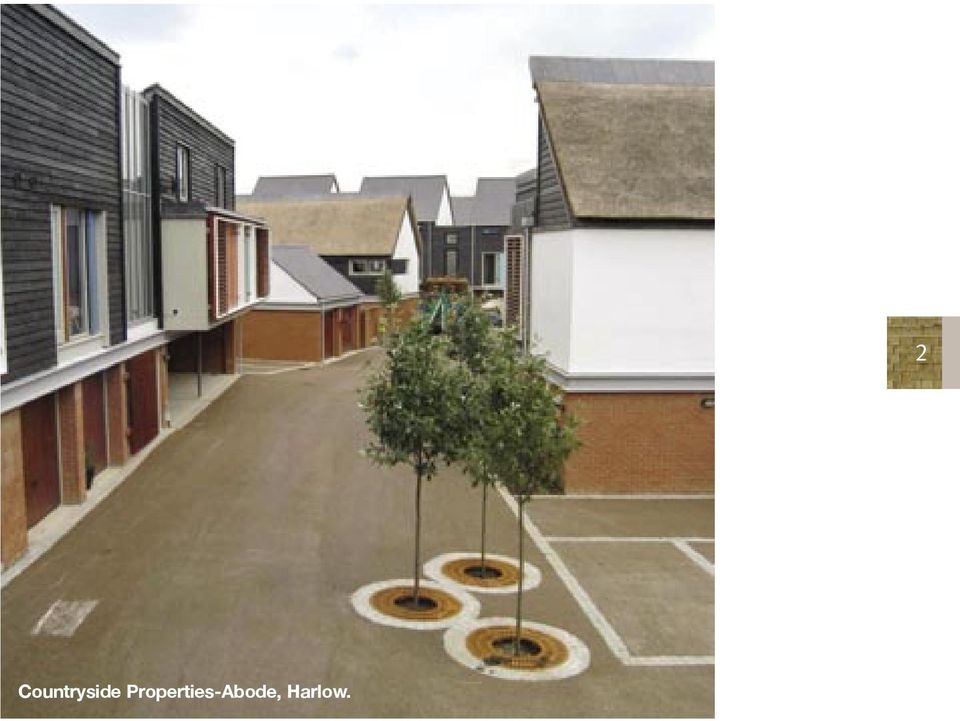
4 Countryside Properties-Abode, Harlow. 2
5 Public Consultations 3 The 1997 Guide was advertised and available on deposit at Branch Libraries and District Council offices throughout Essex during September An earlier draft was circulated for technical consultation in 1996 to a large number of bodies including: Planning and highways departments of all local authorities in Essex Planning departments of all local authorities bordering Essex The Department of the Environment The Department of Transport The Government Office for the Eastern Region The Prince of Wales Institute of Architecture National Joint Utilities Group Essex Chapters of the Royal Institute of British Architects Royal Town Planning Institute National House Building Council House Builders Federation, South-East and London Regions Council for the Protection of Rural Essex Civic Trust John Noble (author of Design Bulletin 32) Royal Institute of Chartered Surveyors, Eastern Region National Federation of Housing Associations Urban Design Group Town and Country Planning Association Association of County and District Councils Planning Officers Association Essex County Police Essex Fire and Rescue Service Essex Building Surveyors Association Access Committee for England Essex Access Forum Anglia Polytechnic University Oxford Brookes University University of the South Bank Liverpool University English Nature Various housebuilding firms and architectural practices active in Essex In 1997 the Guide was the subject of an Essex County Council Safety Audit.

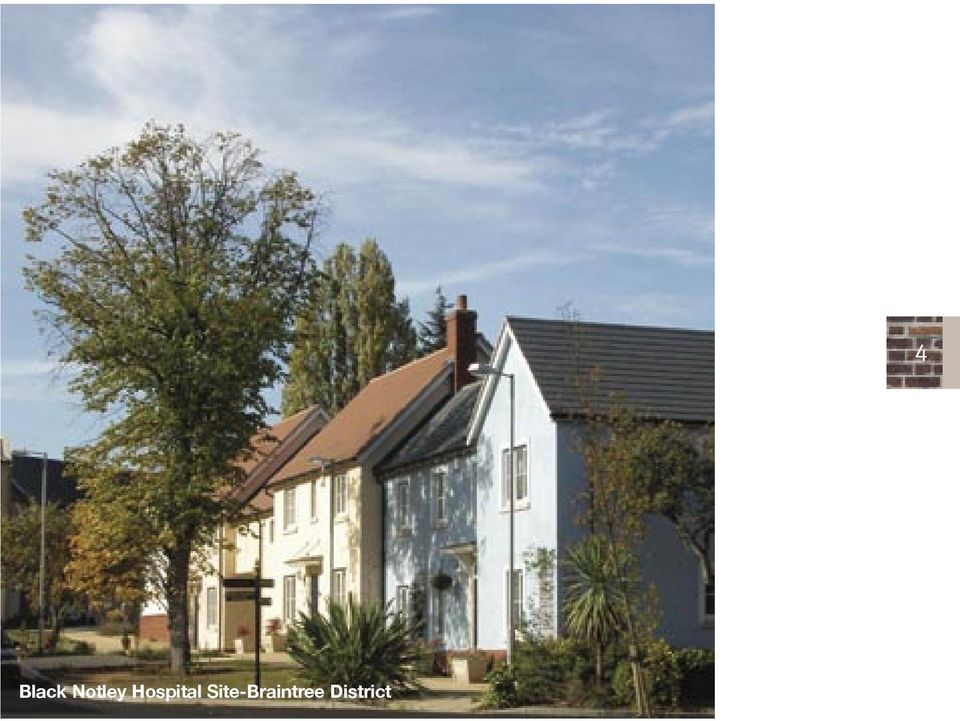
6 Black Notley Hospital Site-Braintree District 4
7 5 Contents Foreword 1 Public Consultation 3 Introduction 7 Planning Context 11 Application of the Design Guide 12 Essex Character 13 Principles of spatial organisation 15 Context and Site Appraisal 19 Environmental Impact Assessment 22 Criteria for all development sites 23 Sustainability 23 Mixed uses 23 Proximity 24 Landscape Structure and Biodiversity 25 Permeability and legibilty of layout 27 Protection against noise sources 35 Public open space 36 Childrens play 37 Public Rights of Way 38 Criteria for layout at densities below 20 dwellings per hectare 39 Arcadia 39 Boulevard Planning 41 Tree and hedge species 43 Design of buildings within the landscape context 43 Criteria for the creation of urban space at densities over 20 dwellings/hectare 45 Pedestrian scale 45 Height of building and width of spaces 46 Criteria for placing buildings at densities over 20 dwellings per hectare 59 Continuity of frontage 59 Relationship of house to road 61 House design within the layout context 65 Daylight and sunlight 67 Rear privacy 69 Private sitting out areas 73 Garden Size 76 Accessibility for disabled people 80

8 Building Form 81 Regional building forms 81 Internal space provision 88 Extendable houses 88 Dormers 90 Sound insulation 91 Placing of openings 92 Solid and void 97 Balance 99 Windows 99 Modelling 101 Appropriate use of materials 103 Appropriate detailing for materials used 104 Chimneys 107 Porches 108 Other details 109 Service and Access 111 Services 111 Access 114 Pedestrian and Cycle Movement 116 Vehicular movement 119 Table of Road Types 120 Shared private drives 137 General design criteria 140 Case Studies 171 Appendices 191 (A) Parker Morris Space Standards 191 (B) Adoption & maintenance of roads etc 193 (C) Recommended plant species 195 (D) Suggested standard planning conditions 197 (E) Indicative house types 199 Credits 209 Bibliography 210 Index 213 6
 Adoption & maintenance of roads etc 193 (C) Recommended plant species 195 (D) Suggested standard planning conditions 197 (E) Indicative house types 199 Credits 209 Bibliography 210")
9 Introduction 7 The Essex Design Guide for Residential Areas first appeared in 1973, published by Essex County Council, and has been used in development control in Essex over the ensuing period. A new version of the guide was published in 1997 and was prepared by a working party of the Essex Planning Officers Association, representing all planning authorities in Essex, with the aim to encourage best practice in the design and layout of residential development. It has been adopted as Supplementary Planning Guidance by many District Councils though with differing levels of commitment to the Guide and its philosophy. The 1973 Design Guide was a response to concern about the poor appearance of new housing areas at the time. It set out underlying visual principles of past and present built environments and objective visual criteria against which proposals could be assessed. Whilst the 1973 Guide has had a measure of success in improving the quality of development the 1997 version developed the principle s of the Guide. A problem which the 1973 Guide did not address was the structuring of development. Both Design Guide and non-design Guide housing frequently has the fault of an over-reliance on cul-de-sac layouts, with the result of disorientation for the vis-itor, indirect routes and lack of route choice for the pedestrian. Cul-de-sac layouts also increase traffic loads on feeder roads and therefore disadvantage residents of those roads. Thinking on residential roads and access evolved and the 1992 revision of the Governments Design Bulletin 32 presented the opportunity for a refinement of standards in the 1997 version of the Guide and is now supported by Places, Streets and Movement, a guide to the design of roads. Increasing confidence in the ability of road design to reduce vehicle speeds and improve safety has resulted in greater flexibility in the ways in which roads can be laid out so as to enhance rather than detract from visual character and create coherence rather than fragmentation. Pedestrian movement is seen as better catered for by short strategic links between elements of the road system rather than by long segregated spine footpaths.

10 Surburban dream Surburban reality The influence of the 1997 Design Guide can be seen in the county and has directly led to more developments with a good sense of place and more responsive to context. There are good examples of continuous frontage buildings creating spaces with character and there are a number of developments which successfully demonstrate ways of accommodating the car with sympathetic highways design that achieve successful co-existence of pedestrians and cars in shared surfaces. Unfortunately there are still cases where there have been attempts to apply the Design Guide principles, but the housebuilder still wants to purvey the familiar suburban ideal of the detached house on its plot. The problem is that when back gardens and side ways have been squeezed to get as many houses on the site as possible, and multiple car ownership catered for, often in front of houses, this ideal becomes unworkable. In such cases it has been possible to achieve no more than a compromise. Housebuilders often argue that their approach is dictated by the market, and yet, in those cases where there has been a more thoroughgoing acceptance of the principles of the Guide, the more attractive results have engendered a ready response from house purchasers. Since the publication of the 1997 Design Guide there have been a number of changes in the context for setting physical criteria. Government planning guidance requires all development to be as least 30 dwellings per hectare to make efficient use of land, there is more attention given to developing 8

11 9 brownfield sites in urban areas where a sensitivity to context is more important, much less reliance on greenfield sites, more pressure for flats in new development and interest in creating home zones. There is a greater emphasis on sustainability, designing for energy efficiency, recycling resources, sustainable urban drainage. and encouragement of off- site manufacture for housing with implications for character. The guidance within the 1997 document is, however, still relevant and this 2005 edition of the Guide has reviewed and updated information where necessary and should be read in conjunction with its companion document The Urban Place Supplement which contains further guidance applicable to most developments in urban areas. This Guide should help many of those responsible for producing the built environment understand that housing developments should have a sense of place, be legible, pedestrian friendly and sustainable which help create successful living environments. Black Notley Hospital Site-Braintree District

12 Summary of Requirements of the Guide A site appraisal is required for all development sites - see page 19 Any residential development larger than 500 dwellings must incorporate some mixed-use development of an employment and/or retail nature - see page 23 Sustainability issues must be addressed for development sites The layout structure on development sites must be both permeable and legible, see page 27 There is emphasis given to the need for continuity of built frontage and the setting forward of buildings to enclose space in the case of densities over 20 dwellings per hectare (8 dwellings per acre) see page 59 Schemes must be designed with crime prevention in mind, see pages 27 and 61 Access for the disabled must be provided in certain situations, see page 80 Any residential development containing a road over 100 metres in length must be designed to reduce traffic speeds to 20 mph (30 kph) by means of physical speed restraints, see page 119 Where future residents are prepared to enter into an agreement not to own cars, it is possible to lay out residential development as a Car Free Zone, see page
 see page 59 Schemes must be designed with crime prevention in mind, see pages 27 and 61 Access for the disabled must be provided in certain situations, see page 80 Any")
13 The Planning Context 11 The draft East of England Plan identifies broad areas for growth and development in Essex and provides a strategy for sustainable development. Its policies provide a framework that support protecting the natural and built environment; delivery of integrated patterns of land use and movement; minimising the use of resources and environmental impact of travel; sustaining the viability of our town centres and making use of previously developed land. Local Authorities Development Plan Documents specify which sites and locations are appropriate for different types of the development and they contain policies that require all new development to be well designed and to fit in with its surroundings. It is the purpose of this document to provide Supplementary Planning Guidance as to how to achieve these aims, and it should be read in conjunction with other design advice contained in the Local Authoritys Development Plan Documents and design briefs. The government also issues advice in the form of Planning Policy Guidance Notes, Companion Guides, Traffic Advisory Leaflets, Design Bulletins, etc. Generally, planning authorities are expected to ensure that development is environmentally sustainable, efficient and well located in its use of land, does not give rise to unnecessary use of motor vehicles, is energy-efficient, is safe to move about in, provides minimum opportunity for crime, does not disadvantage the disabled and, significantly, is well designed in terms of its appearance. PPS1 recognises that the appearance of a development is a material planning consideration and draws particular attention to the importance of high quality design in creating mixed developments and well planned public places. Design should improve the character and quality of an area and be appropriate to its context,and development should create or reinforce local distinctiveness.planning authorities should have regard to good practice set out in By Design-Urban design in the planning system ODPM, CABE It has also been established by case law* that the design of individual buildings is also a consideration insofar as it affects the layout, and this Guide therefore extends to the detailed design of dwellings. * Tarmac Homes (Essex) Ltd v Secretary of State for the Environment and Epping Forest District Council, 1990.

14 PPG3 (2000) emphasises the importance of urban design in achieving high quality environments. It encourages a more efficient use of land and links intensity of development to sustainable locations and access to public transport and promotes mixed use development and tenure. The needs of pedestrians and the role of landscaping in new development are also recognised. Useful guidance can be found in the companion document to PPG3 Better Places to live: By design ODPM 2001 PPG13 aims to integrate planning and transport and recommends that new development should create places that connect with each other sustainably to reduce reliance on the car, and the design and layout of developments should take account of the needs and safety of the community. Advice on the design of residential road and footpaths is contained in Places Streets and Movement: a companion document to design bulletin 32 (ODPM 1998) PPG17 supports the establishment of local networks of high quality well managed open spaces and recreational facilities. New green spaces should add to and enhance the range and quality of existing facilities and should be easily accessible by walking and cycling. See Assessing needs and opportunities: PPG 17 companion guide ODPM 2002 for further advise. 12 Application of the Design Guide PPS1 states that high quality and inclusive design should be the aim of all those involved in the development process. It is primarily the responsibility of developers, designers and their clients to recognise the benefits of engaging skilled advisers. Unfortunately the majority of planning applications for residential development in Essex continue to be submitted without the assistance of an architect. At the same time, were good design to be dismissed as a matter of opinion or taste, planning authorities would be left open to accepting the lowest common denominator of quality. By setting out a clearly related structure of design and layout principles, planning authorities have a basis for refusing obviously poor schemes, as required by PPG3. As Supplementary Planning Guidance, this Guide is part of planning policy, and it is therefore not the intention that its provisions be set aside in exchange for other planning obligations, e.g. the provision of social housing by a developer, that may be negotiated by a planning authority.

15 13 Context Some sites will be greenfield, such as a sustainable urban extension, in which the context of surrounding development is not significant. Others will have to fit into a context of pre-existing development. Depending on the context, the planning authority will have to determine whether a new scheme should perpetuate the format of the surrounding area or establish a new one. If surrounding development has a strong pattern and character that could be detracted from by insensitive new development, the new scheme should pick up the theme of the existing and seek to enhance it. This would be the case, for example, with a site surrounded by pre-20th century development. Obviously a context consisting of average twentieth century housing will not fall into this category. If, more typically, the surrounding area has no distinctive character and only a weak identity, the preferable course may be to establish a strong, new pattern, based on the principles in this Guide, that creates a new character while physically integrating with the surrounding area and forms a focus for it. In the case of, say, a nineteenth century context, the planning authority would have to be selective in its choice of policies from this Guide if it wished new development to fit in with its context. Essex Character It is the aim of this Guide to encourage new development to respect and fit in with the character of traditional Essex towns and villages. Obviously this character is very varied, but for the purposes of new housing it is the background urban texture of a historic settlement which is important. (a) Pre-18th century pattern A surprisingly large proportion of the core areas of historic settlements is made up of structures and layouts dating from before the 18th century. Generally buildings are joined together and directly front the street without front gardens. Building elements are shallow in plan - no more than 5 metres - and roofed at 50 degree pitch, with the skyline enlivened by chimneys and dormers. More usually the flank of the building is presented to the street, but gables and jetties project at intervals. Buildings of this

16 date are timber framed and normally rendered in smooth lime plaster and roofed in hand-made plain clay tiles. White painted weatherboarding is sometimes found, particularly in coastal areas, and black-painted weatherboarding and clay pantiles on outbuildings and barns. (b) 18th and 19th century pattern 18th and 19th century buildings are generally deeper in plan, typically two rooms deep, and have shallower pitched roofs, down to 30 degrees. In the 18th century these buildings tend to appear as incidents within the historic townscape. They are typically of orange-red brick with tiled or slate roofs and vertically-proportioned sliding sash windows. In addition, many older buildings were refronted in this style at the same period, but their origins are betrayed by their shallower plan and original roofs. In the 19th century buildings also appear as incidents in the historic townscape, but whole streets of usually terrace but sometimes semi-detached houses start to be developed. Sometimes houses are built up to the street frontage and sometimes they have enclosed front gardens. They have vertically proportioned sash windows and substantial, centrally placed chimney stacks. In addition to red brick and tiled roofs, slate roofs are very common, and gault and Suffolk white bricks are found in the north of the county, with yellow London stock bricks in the south. (c) 20th century Whilst the 19th century disciplines survive up to 1914, the rest of the 20th century is characterised by a fragmentation of built form much of which has largely failed to relate to the townscape of previous centuries. Houses tend to be detached or semi-detached, sit on individual plots and are set back from the road. This type of development is referred to as suburban, and is typical of that found in all parts of the country. The format of such housing can be handled successfully in design terms, however, but only at densities below 20 houses per hectare (8 dwellings per acre) - see page 39 - in order to provide an adequate landscape setting. At higher densities the aim should be to create urban streets typical of pre-20th century development. 14

17 The Principles of Spatial Organisation The aim of fitting in with the character of traditional towns and villages requires, for its fulfilment, the enclosure of space, whether by buildings or by landscape. Enclosed spaces are visually pleasing and create a sense of place. They provide variety of visual interest, and are more comfortable at the pedestrian scale. If the space is too large, a frequent problem, there is a loss of comfortable contact with the surroundings and a tendency towards a feeling of agoraphobia. The counterpart, less frequently encountered, is a space which is too small, leading towards a feeling of claustrophobia. Enclosed spaces also create safer and more secure environments, and influence drivers perception of speed in residential areas. Traditionally there are two ways of organising space and buildings: 15 A Rural System Here the landscape contains the buildings. Buildings are set in landscape space: a mansion in its park or a group of farm buildings in their natural agricultural setting. The key is: Landscape Containing Buildings

18 B Urban System Here the previous example is reversed, with buildings containing the space: the streets, squares, alleys and courts which make up the character of our historic towns and villages. The key is: Buildings Containing the Space 16 C Unsatisfactory Suburbia Much twentieth century housing development has failed to recognise these two basic principles. This has resulted in unsatisfactory suburbia, where there are too many buildings for the landscape to dominate and yet buildings are too loosely grouped or of insufficient height to enclose space. THIS IS THE FIRST AND MOST IMPORTANT REASON FOR THE VISUAL FAILURE OF MUCH HOUSING DEVELOPMENT. PHOTO TO GO HERE

19 Spectrum of Visual Density 17 Rural situation Arcadia Boulevard Planning Unsatifactory Suburbia Urban Situation Large Town/City Centre scale

20 The increase in visual density from uninhabited landscape to the urbanity of the city may be viewed as a spectrum with individual buildings in the lansdscape forming one extremity and the city centre the other, and all other types of settlement pattern coming in between. At the beginning of the spectrum is the truly rural situation, where an isolated dwelling or small group is located in the landscape. As such development is a very small proportion of the total of new building, detailed consideration falls outside the scope of this document. Suffice it to say that on such occasions siting and relationship to landscape should receive the same sort of care as would a proposal in a Conservation Area. Next come those types of development where there is a greater quantity of housing laid out according to landscape-dominated principles, creating the illusion of a rural environment in a residential area. This is Arcadia, and its principles are set out on page 39. This effect cannot usually be achieved at densities over 8 houses per hectare (3 houses per acre). Then come those types of development in which trees still predominate and enclose the public space, but a more formal arrangement of the houses permits higher density, 10 to 20 houses per hectare (4 to 8 houses per acre). This is Boulevard Planning, and its principles are set out on pages 41 and 42. In the middle of the spectrum is Unsatisfactory Suburbia, where houses are still set on plots, but in such a cramped fashion that there is no illusion of the houses being within a landscape setting yet the houses are too loosely grouped to contain spaces satisfactorily. Frontages are fragmented by gaps, and the public space dominated by estate roads and car hardstandings. This failure to organise space properly is the most fundamental reason why most suburbia fails visually. 18

21 At the farther end of the spectrum are urban groupings in which space is enclosed by more or less continuous building frontages. The principles of handling this kind of development are set out on page 45 on Development at Densities above 20 houses per hectare (8 houses per acre). These are the types of grouping characteristic of historic towns and villages in Essex. The large town centre situation relates to the mixed forms and uses which can create a varied urban character within these larger denser urban settlements. This falls within the scope of the The Urban Place Supplement, the companion guide to this document. In a large development, one would expect to see a variety of densities of development, from Arcadia to urban groupings. 19 Context and Site Appraisal The planning applicant should carry out an appraisal of the site and surrounding area before designing the scheme. THE CONTEXT AND SITE APPRAISAL MUST PRECEDE OR ACCOMPANY THE PLANNING APPLICATION. All sites will require a built form and spatial context appraisal and site analysis. In the case of sites larger than 0.1h, with the exception of sustainable urban extensions, a more rigorous appraisal of the context is required which examines uses, how an area operates, and the housing needs and demands on services and facilities within the local area. Information on the Context Appraisal methodology is contained within the companion document The Urban Place Supplement. Bus 3 Facility 2 4 Pub 1 1. Stream 2. Trees 3. Farm 4. Contours
22 For the site analysis the following aspects should be covered, which should be illustrated by annotated plans, photographs and sketches An analysis of visual and physical character of the site and the visual and physical relationship of the site to its townscape and landscape context Views into and out of the site, landmarks in the surrounding area Existing movement pattern, barriers to movement and desire lines across and around the site. Proximity to public transport routes, stops, and the frequency of service Access points to the site Existing and potential nodal points within or near the site Existing buildings and structures on and adjacent to the site and whether they are to be retained Wayleaves and easement strips that cannot be built on slopes, wind shelter, overshadowing trees, their spread, height and condition, hedges, boundary features and whether they are to be retained Wildlife habitats and whether they are to be preserved Presence of filled ground and potential sources of contamination (a Contaminated Land Risk Assessment to be submitted if appropriate at the planning application stage) Potential sources of noise pollution (a Noise Impact Assessment to be submitted if appropriate at the planning application stage) Archaeology (an Archaeological Evaluation to be submitted if appropriate at the planning application stage) 20 Decisions should be made as to where built frontages are required and to what scale in terms of building heights. For example, an existing road frontage may need continuation, or a space which is already partly enclosed may need completion of the enclosure by the new development. Attention should also be paid to ensure that the new development is a good neighbour to existing properties, for example that the sides and rears of existing properties do not become a frontage to a new road or publicly accessible area.
23 1 4 Need to continue existing frontage Infill sites Need to complete partially enclosed space 21 New street frontage to existing side Existing Existing side remains private Existing Incorrect Correct Existing key views and landmark buildings should be identified and respected by the new scheme. Similarly, points where new key buildings and views are required should be established, and the desirable form they should take.
24 Existing landmark building Infill site New development Environmental Impact Assessment The planning applicant should also establish whether the development would require an Environmental Impact Assessment (EIA), which is a procedure for ensuring that the impacts of a development are fully understood and taken into account before development is granted planning consent. It is likely that only major urban developments or proposals in sensitive areas that could have significant effects on the environment will be subject to the requirements of an Environmental Impact Assessment (EIA). The Local Planning Authority should be able to advise on whether an EIA is required. The procedure for an EIA requires the applicant to compile an Environmental Statement (ES) which contains information on the environmental impacts of the development and proposed mitigation measures. The preparation of the ES in parallel with the project design can provide a useful framework within which environmental considerations and design development can interact, encouraging appropriate modifications to the development to avoid or minimise environmental damage and maximise environmental benefits. Further information on environmental assessment is provided in the document The Essex Guide to Environmental Impact Assessment-2005 EPOA (Essex Planning Officers Association). 22
25 23 Criteria for all development sites Sustainability Environmental sustainability is to do with ensuring that new development does not impose unacceptable burdens on local eco-systems, is located with easy access to transport and facilities, is located with easy access to transport and facilities, is designed to last a long time to adapt to changing needs and to use resources efficiently in construction and use. The development has a mix of residential and employment uses, tenures and dwelling sizes in order to reduce the need to travel. See paragraph on Proximity below; Sustainability, requirements will need to be addressed in the following respects The development is laid out in such a way as to maximise proximity to facilities and public transport and to encourage walking and cycling instead of the use of cars. See paragraph on Proximity below The development is laid out in such a way as to safeguard the existing ecology and improve the natural habitat. See paragraph on Landscape Structure and biodiversity Buildings should be designed and constructed to minimise energy consumption, conserve water resources and reduce its consumption, recycle materials and reduce waste. All developments should aim to meet the Eco-Home and BREEAM excellent standard. See The Urban Place Supplement for further information Mixed Uses It is desirable that most larger developments incorporate a range of non-residential uses, both facilities for residents, such as shops, schools and community facilities, and also employment uses, such as offices and residential-compatible light industry. The location of these within predominantly residential areas will reduce the need for travel to work and
26 facilities. No development of more than 500 dwellings should be without such employment uses integrally located within the development rather than in a peripheral business park. A mix of uses should also be included within smaller residential developments if the site is over 0.1h in area within 800m of a large urban centre or 400m of neighbourhood centre, and located on a major route to these centres. Similarly, a mix of tenures and dwelling sizes maximises choice of location for residents and thereby reduces the need to travel. Development located within walking distance to a range of services and facilities and close to a major transport corridor may justify a reduction in car parking requirements. Proximity The location of dwellings, facilities and public transport in close proximity encourages walking and cycling instead of car use for local trips. Facilities, shops, employment, schools, etc should be clustered together on routes, pedestrian or vehicular, which lead directly into the cluster from surrounding, predominantly residential areas. Residential accommodation should be mixed in with these other uses. Such clusters, neighbourhood centres or core areas, should be on a bus route, and no part of a residential area should be farther than 600 metres from such a cluster 24 Preferably no part of a residential area should be farther than: 400 metres from a regular bus route 600 metres from a primary school 1,500 metres from a secondary school. Within 300 metres of a regular bus route, neighbourhood centre, cluster of facilities or town centre residential densities should be higher so as to place a greater proportion of residents within closer walking distance of facilities. See The Urban Place Supplement for further guidance on designing development at higher densities.
27 25 Landscape Structure and Biodiversity Development which provides a greener environment can be more sustainable and deliver important environmental, social and economic benefits. Trees and plants can help off-set climate change as well as provide habitats for different species. Green spaces provide important recreational benefits, can encourage social cohesion by acting as a community resource, improve the quality of life for communities by providing visually attractive spaces and can also increase property values All larger development should be designed around a landscape structure. This should take as its starting point any existing land forms, water, vegetation and built features, which would act as form-givers for the development with the purpose of assisting in achieving uniqueness of character. Existing ecology and natural habitats found on the site must be safeguarded and enhanced and new opportunities for increasing the biodiversity should be explored. Where possible damage to functioning ecosystems, their associated habitats and species is unavoidable, measures must be proposed to mitigate and compensate for these impacts. A scoping study at the beginning of the development process can help to identify the constraints and opportunities on a site and highlight areas where a more detailed survey is required Retained landscape features as formgivers for development 2. Tree screen and underplanting 3. Wildlife corridor 4. Short break 5. Open space 6. To next open space
28 The landscape structure should encompass the public open space system (see page 36) but should also provide visual contrast to the built environment and constitute a legible network based, where appropriate, on existing trees and hedgerows. A block of trees visible above rooftops, for example, helps the legibility of a development from outside. The landscape structure should, in addition, create a network of wildlife corridors linking with public open spaces and nearby countryside and, if little biodiversity interest has been identified, include features that will help create new habitats Where based on retention of hedgerows, these should be within the public realm (not just in back gardens). The links should be fairly continuous (ie short breaks are possible) and should contain mixed indigenous tree and other plant species (see Appendix C) and some long grass, which provides protection for wildlife and attracts some species of nesting birds. Attention should be given to the creation of interdependent plant communities. Where there is an exposed edge to open countryside, the planting of tree shelter belts around the edge of developments, especially on the north-east side, can reduce heat loss from dwellings within 150 metres in cold weather. Indigenous woodland tree species should be used, together with a mixture of evergreen and deciduous underplanting. Trees also have an important role to play in more urban spaces. See page 55. The design of the surface water run-off system should be considered in conjunction with the landscape structure. Balancing ponds for storm-water should contain a permanent body of water, and can be a valuable ecological and landscape feature. Planned absorption of surface water into the ground can help the water table level, though this is unlikely to be feasible in clay areas. Buildings and private spaces can also be exploited to create a range of different habitats. Climbing plants can colonise walls, and green/brown roofs roof terraces, balconies and gardens can also create habitats for wildlife. The management and aftercare of green spaces, landscaping and protection of habitat and species will need to be considered and where necessary a management plan agreed with the Local Planning Authority. 26
29 Permeability and Legibility of the layout A street layout that encourages walking and cycling is permeable, in that it is well connected and offers a choice of direct routes to all destinations. It is also legible, in that it is structured by a distribution of distinctive places and spaces so that it can be read and is thus easy to find one s way around. The following paragraphs explain how this can be achieved. 27 The Street System A residential area should be structured by a street system made up of urban spaces formed according to the principles set out on pages 45 to 58. The design of the street system should start from the need to establish a clear, legible, articulating structure for the area, not from the technical demands of traffic. This layout may, in part, be suggested by the topography, natural desire lines and accesses to the site. The street system should be plumbed for traffic circulation, pedestrian use or cycleways after its form has been established by urban design criteria. Permeability It should be possible for pedestrians and cyclists to move freely between all parts of a layout, both locally and on a wider scale. The disadvantage of a layout based entirely on culs-de-sac and loops is that routes for pedestrians are indirect and boring and therefore pedestrian movement is discouraged. This creates dead areas which are vulnerable to property related crime. Furthermore, cul-de-sac layouts result in higher traffic levels on feeder roads, with a consequent loss of amenity to residents of those roads. Cul de sac layout B A Indirect pedestrian route and lack of route choice Heavier traffic loads
30 Existing 7 New 5 1. Pedestrian/cycle street linking parts of road network 2. Crossroads possible where one branch serves few dwellings 3. Nodal point 4. Frontage to major road reserved by private drives 5. Pedestrian/cycle link across major road 6. Ransom strip prohibits vehicle access 7. Pedestrian/cycle link between new and existing A more permeable layout offers the pedestrian a choice of routes, which offers greater visual interest and therefore generates a higher level of pedestrian activity, and thus security. If there are more pedestrians around in the street there is a greater chance of casual social encounters and less chance of thieves being able to gain access unobserved to houses or cars. In order to allow free movement the ideal would be a deformed grid based on the small residential block. The advantages of culs-de-sac and loops in preserving amenity and quiet and supervised space can be combined with those of a permeable layout for pedestrians by bringing heads of culs-de-sac together, by creating pedestrian/cycle streets between parts of the road system, and by creating pedestrian/cycle links across major roads that would otherwise form a barrier. There should be good connections between adjacent housing schemes, and wherever possible a choice of route between one location and another. Where it is not possible for traffic routes to link old and new residential areas, either because of ransom strips having been left by developers, or else because of the undesirability of introducing new traffic into existing residential areas, there is often no reason why pedestrian and cycle links cannot be made between one area and another provided these links are overlooked. The aim of permeability is not, however, one that should be pursued to the exclusion of the need expressed below to focus the layout on cores and nodal points. 28
31 Incorrect- conventional neighbourhood centre Correct- a neighbourhood core centre 1. Buildings located in isolated fashion 2. Residential area segregated from community facilities 3. Pedestrian access across major road and car park 4. Buildings directly front streets. High concentration of entrances 5. Car parks fragmented and located at rear 6. Residential buildings form continuous frontage with community facilities 29 Legibility The Core The street network should focus on a core area of greatest pedestrian concentration. Large developments may need to provide this core on site. Smaller developments may focus on an existing core on a neighbouring site. It is here that any non-residential uses should be located, eg primary school, community hall, local shops, pub and bus stop, and residential densities should be higher in this vicinity. The core area should be characterised by a high concentration of entrances to buildings opening directly off the street. Buildings should not be located in an isolated fashion, separated by car parks or access roads, and residential and non-residential land-uses should merge into one another. Focus on a core area within the site Focus on a core area on a neighbouring site
32 The street system should radiate from the core area, with radial routes being more direct, and minor linking routes being more tortuous. These relationships of core to periphery have been found to generate greater levels of pedestrian activity. Core area Contrast in character between adjacent areas Nodal points Possible lower density between nodal points Picture A Picture B 30 Nodal Points In addition to cores where non-residential elements can be introduced, it is desirable to structure a residential area around a series of nodal points. These may be irregular or regular shaped urban spaces formed at junctions of routes, and may be emphasised by key buildings or groups of buildings. Residential densities may be higher in the vicinity of such nodal points, forming a village cluster, with lower density areas between one cluster and the next. Provided there is sufficient concentration of non-residential uses and community facilities in the main core area, it may be appropriate to locate some other community facilities, e.g. convenience shop, child care nursery or pub, at nodal points to act as a focus and generate pedestrian movement. (Picture A) Character Areas A large residential area should have a variation in character between different parts. This variation should not be based on development density or artificial creation of social differences, but on different types of space, building forms and materials. Whilst it is an aim to build in identity and sense of place into all parts of a development, the creation of a particular identity in different parts of the development will do much to define the special character of each area. (Picture B)
33 An edge onto a public open space 2. Access from major road 3. Access from rear Edges Edges may be the outside urban edge to countryside, an edge against a major road, an edge against an open space, or a line of transition between an area of one character and that of a different character. According to their importance, edges should be treated in different ways. Public open spaces should be treated as focuses on to which houses front, rather than tucked away behind the backs of houses. In order to avoid domination by back fences, major roads and countryside edges should also be fronted by houses, even where it is not possible to take vehicular access direct from the major road, and access has instead to be taken from service roads or private drives running parallel to the road, or else from behind. Urban Grain In those cases in which it is decided to perpetuate the pattern of the surrounding area, attention should be paid to repeating the urban grain determined by the pattern of plot subdivision and building form. For example, where terraces of houses are the norm, the new development
34 should also consist largely of terraces. Where houses are set forward up to the street line, the new development should do the same. Where the existing pattern is irregular, irregularity should also be characteristic of the new scheme. The designer should beware of laying out the new development to a pattern generated by the T-square on his drawing board or by the internal logic of the site, which does not relate to the surrounding urban grain and which may result in a ragged, unconsidered edge to existing development. Care should be taken to resolve any mismatch of orientation within the site, to the benefit both of the relationship with adjoining areas and of the consequently enhanced interest of the spaces within the site. Edge forms street with existing development 32 Layout generated by internal logic of site Ragged, unconsidered edge Incorrect Mismatch of orientation resolved within the site, forming more interesting internal space Correct Landmarks Landmarks are distinctive buildings, spaces, sculptures, etc that should be placed at points in the network where they can aid orientation. They can be particularly useful in areas away from nodal points or other distinctive places. They may also fulfil a useful function in aiding orientation in the view from a major road. A landmark could be not only a distinctive building, but a taller one, designed to be seen over a wider area.
35 Landmark building Bishops Mead-Chelmsford 33 External Image As seen from the surrounding landscape, the development should have a clear and well-defined image. This is achieved by: a clear design treatment of the urban edge (see page 31) clear and defined entrances to the development (eg pinch points) skyline and roofscape, which is made up of a texture of roof forms generated by the forms of individual houses the location and roof treatment of key buildings within the development, which will aid orientation. Taller buildings and blocks of trees also serve to structure the external view External Image 1. Clear entrance 2. Key buildings 3. Block of trees 4. Well defined urban edge
36 Countryside Properties-Hart Street, Brentwood. 34
37 Protection against Noise Sources The best way to limit the effects of external noise is to locate new housing away from major noise sources, e.g. heavily trafficked main roads, airports or heavy industry. PPG24 Planning and Noise recommends that sites subject to noise levels above 72 db LAeq, T between the hours of and and 66 db LAeq,T between the hours of and 07.00, should not be used for new housing. Sites subject to between 55 and 72 db LAeq, T and between 45 and 66 db LAeq, T may only be developed if suitably protected from the noise source. Barrier blocks of single-aspect housing are a way of protecting these sites, as are earth mounds etc. 5 6 Aspect 1. Continuous barrier block 2. Small acoustically double glazed windows 3. Bathroom 4. Bedrooms 5. Living rooms 6. Interior of site protected from noise by barrier block 7. Noise source
38 Public Open Space All open space in a development should be obviously useful and visually pleasant. Thus all public areas, whether squares, streets, pedestrian links or parking courts are part of the provision of different types of space, each with their own function and all designed to provide a high level of amenity. The provision of arbitrary pieces of public open space can result in spaces that are divorced from the main pattern of public street spaces, are neither useful nor attractive, and indeed are a nuisance to residents. They are also expensive to maintain. Experience shows that the most effective public open spaces are large, multi-purpose informally supervised parks. These are best allocated by the Local Plan/Development Framework process or in a Design Brief and those planning authorities that operate a percentage open space policy should aggregate the requirements of a number of smaller developments to create these larger, more useful open spaces. This is becoming even more necessary as Parks and Leisure Departments feel the effects of financial stringency and are less willing to adopt smaller and more uneconomic open spaces. In some cases management companies may have to be set up to run and maintain open spaces of whatever size. Whilst parks should be the key open space provision, there is a role for additional smaller, more localised open spaces in order to create a more varied townscape. On page 77 it is suggested that houses should have reduced private garden areas provided they face, back on to or are immediatley adjacent to a substantial area of well landscaped and properly maintained communal open space. This is the situation analogous to the Georgian square, and in such cases it would be appropriate for the space to be maintained by a management company. This provision compensates for smaller gardens and should be additional to any percent get open space requirement by a planning authority. Parks and school playing fields should preferably be fronted by houses rather than tucked away behind so that they become a more obvious part of the circulation system, benefit from informal supervision from the houses and contribute to the amenity of outlook of the houses. They should be a focus for the pedestrian and cycle network, and it should not be necessary to cross a main road (Type 2 or above) in order to get to one. 36
39 Children s Play Whilst the safest place for small children to play is the back garden, it is recognised that, for many types of play activity, older children prefer to play in roads and parking courts. Provided the road system is designed for slow vehicular movement and gives priority to the pedestrian there is no reason why this cannot be accommodated, and the addition of objects such as railings and benches, with extra paved area as part of the street space, can facilitate play and help populate the street, which has the benefit of reducing the opportunity for crime. 37 Where there are a number of family dwellings with less than 100 sq m gardens, DOE Circular 79/72 recommended provision of play space on the basis of 3 sq m per child bedspace which, at urban densities of dwellings per acre (25-37 dwellings per hectare) would result in 3-4 per cent of the site being given over to children s playspace.
40 Public Rights of Way It is crucial that Public Rights of Way (not only those that are already recorded on the Definitive Map, but also claimed routes and opportunities to create) are considered from the very start of a proposed development. If this is overlooked, then Public Rights of Way issues can result in significant delay later on and even render properties unsaleable. Legal powers do exist to demolish buildings that obstruct Public Rights of Way. Public Rights of Way can only be altered by a Legal Order, even if changes are only temporary. Planning permission alone does not give the right to interfere, obstruct or divert a Public Right of Way. Because of the legal processes involved it is essential that early discussion takes place, ideally before an application is submitted. Path networks form an integral part of any large development by providing a functional and sustainable link to shops, services, schools and also for recreation by linking urban areas with the countryside. With careful consideration they can be a very positive asset to a development. Further advice can be obtained from contacting the Public Rights of Way team based at County Hall, Chelmsford. A guide entitled Development and Public Rights of Way is also available. 38
41 Criteria for layout at densities below 20 dwellings per hectare (8 dwellings per acre) The aim, as of criteria for layout at higher densities, is the creation of a pedestrian scaled environment by means of enclosing space and structuring chains of spaces. The difference is that the space is enclosed by trees, hedges and shrubs rather than buildings, which become free-standing rather than space-enclosing elements and are contained within the landscape; this is the legitimate context for the detached house. 39 Arcadia Densities up to 8 houses per hectare (3 houses per acre) Arcadia is the creation of the illusion of a rural environment by using the picturesque approach to landscape design as typified by the layout of parks of great country houses in the eighteenth century. The principle was the use of meandering walks which successively revealed surprise features hidden in a dominant landscape. In the same way, early leafy suburbs of the nineteenth and early twentieth century conceal houses among mature trees so that the visitor is more aware of the landscape setting than of the houses. Today s Arcadia should strive for the same effect, with a layout devised to allow houses to appear at intervals among trees as surprise features in the landscape. This effect cannot be achieved at densities over 8 houses per hectare (3 houses per acre). Land economics may well dictate that housing at this density is at present the exception rather than the rule in new residential areas. If a planning authority wishes to see a wider use made of development laid out according to Arcadian principles, it would do well to consider a special notation for such sites in its Development Plan Documents in order to predetermine an appropriate land value.
42 As Arcadia is dependent for its effect on a dominant landscape, the most suitable sites will be those which already have a significant density of mature trees and hedges. Consideration must also be given to how the existing tree cover can be enhanced by new planting or, where existing vegetation is sparse, a new pattern of substantial tree and hedge cover can rapidly be established. The need for rapid establishment should not, however, influence a choice of plant material that is alien to naturally occurring species in Essex. (Appendix C) Front gardens should be enclosed by hedges in order for the landscape to dominate the houses. Clearly, open plan front lawns that show off cars parked on drives, built enclosures such as walls with railings, substantial gates, etc. are not appropriate to this concept. 40 Arcadia Boulevard
43 41 Boulevard Planning Densities up to 13 houses per hectare (5 houses per acre) Boulevard Planning employs the rural principle of spatial organisation, in that the landscape dominates the buildings. However, it also uses some of the urban principles of design, in that trees are used to enclose spaces in a manner similar to the way buildings are used in the urban situation. There are two possible variations: Large trees grow on the front boundary of gardens (this would have to be a requirement of the planning consent with the established trees protected by Tree Preservation Orders). Houses appear at intervals seen through drive entrances, but no more than one or two are apparent at any viewpoint. Trees always provide the link between one house and the next, with more planting at the rear to unify the composition and contain the space between the houses. Care must be taken to ensure that there is sufficient space for trees to establish and mature. The road is a shared visual space for motorists and pedestrians. The length and variety of linear spaces needed to avoid monotony is broadly governed by the principles explained on page 48. Not less than half width of house Verge Footway Min. 7.5m Varied houses Not less than half width of house Hedge Avenues of trees line the roads and contain the space for the motorist. At intervals, islands of trees appear to terminate vistas - buildings are scarcely noticeable. The pedestrian is contained within an inner space formed by the roadside trees and front garden hedges and trees. Such layouts work particularly well when the streets form straight avenues or meander in a gentle, serpentine manner.
44 Boulevard Planning Densities up to 20 houses per hectare, 8 houses per acre) A further variation is possible with a layout relying on a subtle combination of landscape and buildings. Part of the composition will rely on creating and enclosing spaces by trees and hedges, and part will be reliant on building groups. The right relationship must be created between the height of buildings and trees and the width of the spaces between them, following the principles on page 50. Whilst the use of detached houses is possible in this context, the effect depends on the use of a common architectural style and detailing for all the houses, on locating garages to the rear, and on using gateways, arches, railings, etc to link the houses into one composition. Similarly the houses must be positioned in a strict geometric pattern. It is this geometry of crescent, circus, oval or rectangle that will provide the necessary order. The success of such layouts is dependent on abundant and appropriate tree planting. Sparing use should be made of areas of housing laid out in this way, with layouts at over 20 houses per hectare (8 houses/acre) predominating. On a small site it would not be appropriate to use this format at all. 42
45 43 Layout with housing density up to 20 d.p.h (8 d.p.a) Tree and Hedge Species As a general rule deciduous species should be chosen, as they provide visual interest throughout the year, allowing light and air to penetrate to ground level during winter. Evergreens, however, can be used to conceal unsightly features, or to act as a focal point Trees should have clear stems in public accessible places to avoid providing cover for anti-social behaviour where this Is considered a problem. For further details see Appendix C. The Design of Buildings within the Landscape Context Whilst the design of buildings in, say, the Arcadian context is not as constrained as within the urban context, nevertheless building forms should follow the regional tradition (see page 81), should avoid the deep plan and should follow the recommendations on elevational and detailed design (pages ).
46 Boulevard Planning incorporated within a housing development (for further details see case study 7) 1. Arcadia 2. Formal urban square 3. Boulevard planning 4. Village street 5. Formal urban space
47 Criteria for the creation of urban space at densities over 20 dwellings per hectare (8 dwellings per acre) As already explained, the prime underlying principle of all urban places should be the creation of a pedestrian scaled environment by means of enclosing space by buildings. If space is not satisfactorily enclosed, an attractive urban place cannot be achieved. Similarly chains of spaces must be structured in such a way as to add up to a meaningful urban place. 45 Pedestrian Scale In order to encourage walking, and to create spaces in which people feel comfortable, any publicly accessible spaces must be visually satisfactory to the pedestrian. This means that spaces must be visually comfortable in terms of their height to width ratio (see next page), balance of static and dynamic spaces (page 49) and their visual length (page 54). Pedestrian movement is sufficiently slow to allow scrutiny of one s surroundings and to examine and decode a wealth of visual information, much of it at an unconscious level. Without an abundance of visual stimuli the pedestrian experiences boredom and alienation. There must be sufficient visual interest within the planes of the enclosing buildings to engage the eye. Repetition of similar building forms should be avoided, except where formal spaces are being created and there is compensatory detailed design enrichment. At the same time there should be sufficient density of interest in changes of frontage width and building line, surface texture of facing materials, window and door types, features such as gables, projecting wings, bays, etc. and a varied skyline with chimneys and dormers, to encourage the pedestrian to explore. There is a spectrum between a chaotic proliferation of detail at one end and severe simplicity at the other. Between these extremes an acceptable balance must be struck. Visual variety will be enhanced where there is also variety of building types and uses, ie not purely residential.
48 Visual variety Pedestrian scale Severe simplicity 46 Height of Buildings and Width of Spaces In order to create satisfactory enclosure of space related to the human scale it is necessary to establish a suitable ratio between the width of the space and the height of its enclosing buildings. An ideal relationship for pedestrian-dominated dynamic spaces is for the width of the space to be equal to or less than the height of the enclosing planes. In practice this can be difficult to achieve, and gaps in the height of enclosing buildings, partial widenings of the space, etc should be compensated for by narrowing the rest of the space and/or increasing the building height of one side. The secret of success is that the building must be of sufficient height to command that part of the space. In certain circumstances roof slopes, gables, dormers, chimneys and other skyline features can increase the apparent height of buildings and thus their ability to enclose space.
49 47 Black Notley-Braintree District.
50 Width of space equal to or less than height of enclosing planes Drop in height compensated by rise in height on opposite side of space at A 48 In order to reinforce visual character, define spaces and promote pedestrian movement, most public spaces should be faced by the fronts of buildings and their entrances, not by a predominance of flank elevations or side or rear boundaries. This will contribute to security by enabling informal supervision by residents of public spaces. Correct Incorrect
51 49 Dynamic Spaces Most urban spaces will inevitably be linear and corridor-like, contained by buildings and other features. If the pedestrian alone were to be accommodated, such spaces need be no wider than 2 metres, but the requirements of building outlook and the manoeuvre of vehicles normally preclude such intimate spaces. Generally, the narrower, the longer and the taller the enclosing buildings of such a space, the more it imparts a feeling of dynamic movement. ( Picture A) Static Spaces Whilst the overall network of routes will have a general linear tendency, the skilful introduction of more placid areas will have a welcome effect. These are spaces that encourage the pedestrian to stop and linger. Such static spaces can take a variety of plan forms. Circular spaces and squares bounded by a plane of continuous height are the strongest types. Clearly the impact of the static character can be enhanced or diminished by its architectural treatment. It can be further reinforced by the addition of a central feature. Static spaces should be sufficiently strongly enclosed that a linear feature such as a road passing through does not detract from the feeling of enclosure. Such an effect may be mitigated by a design treatment of the ground plane that emphasises the static nature of the space, but this is no substitute for effective enclosure by buildings. (Picture B) The Problem of Over-wide Spaces Picture A Picture B
52 The space accommodating a vehicular road will inevitably be wider than the ideal situation described on page 48. The pedestrian will perceive such spaces as over-wide. A static space of this width, such as a market square, would, however, not appear over-wide due to its limited length. This effect can also be created by the design of buildings which command and, at least partially, enclose the space. Another solution is to treat each street frontage as a more or less unbroken wall or edge, with the footway hugging the built frontage to give a sense of shelter. A further solution is to subdivide the width of the street by rows of trees to create three parallel spaces, ie two footways and the carriageway. In such cases there could be greater fragmentation of the frontage, as this would be concealed by the trees. (Pictures C, D and E) 50 Buildings commanding and partially enclosing a space Picture C Picture D Street frontage as an unbroken edge Picture E Street as three parallel spaces 1. Continuous wall 2. Zone of shelter
53 51 Length of Spaces An over-long linear space can be daunting or monotonous to the pedestrian as too much is revealed at once. This problem may be overcome by limiting its visual length by complete or partial closure formed by a taller terminal building, a curve in the street, a change in the building line, a pinch point or a change in level. These devices conceal the way ahead and arouse the curiosity of the pedestrian. They also reduce the dynamism of the space. It is necessary to achieve a variety of spatial experiences along a route. This may be done by breaking the linear space into a series of linked sub-spaces more related to the human scale. These sub-spaces can be created or hinted at by relatively minor variations in the height-width relationship, breaks in the frontage line, angling facades, and the detailed design of the buildings. They may be more positively formed by pinch points, bridging over the space, or by wide eaves overhangs and projecting high level features. Linear space as series of linked sub-spaces Pinch point (gateway) Pinch point Sub-spaces emphasised by projections, eaves, overhangs and bridging over
54 Limiting visual length by taller terminal building Limiting visual length by curve in street 52
55 Continuity of Route The continuity of a pedestrian route needs to be emphasised by minimising breaks in the built frontage. Gaps for road junctions, etc need to be sited so as to have as little impact as possible on the visual continuity. The route should be a unifying element, tying groups of buildings together and making its whole length a composition in itself. However, such a route will need a variety of spaces along it in order to provide a diversity of spatial experience. 53 Character of the space A balance should be created between diversity and unity in the overall design treatment. A totally unified scheme would be one in which spaces, building forms, roof pitches, eaves lines, openings and materials were the same throughout the scheme. A totally diverse scheme would be one in which they were all different. The former would be monotonous, whilst the latter would be chaotic. Clearly there is a band of acceptability between these extremes in which a balance must be struck with some elements varying and others consistent, and in this lies the secret of the attractiveness of places. This can be seen in many historic settlements; in some, for example, spaces, forms, roof pitches and eaves vary, whilst Formal space reinforced by formal buildings 2. Formal space contrasted with informal buildings 3. Informal space and buildings
56 a pleasing unity is imparted by consistency of materials and elevational openings. Other settlements owe their character to a variety of materials but with consistency of street frontage and plot width. Another facet of the split between diversity and unity is that between formality and informality. Within the band of acceptability, formal design may be characterised as that in which there are a greater number of consistent elements, tending towards unity, whilst informal design is that in which there is a greater variety in elements, tending towards diversity. Formal design tends to suppress the individuality of the dwelling in the interests of creating an overall composition of greater coherence than would be possible dealing purely with individually expressed units. Spaces may be treated in either a formal or an informal way. A formal space is unified and symmetrical in its treatment, and is based on one or more axes. The character of the space may be reinforced or contrasted by the design of the buildings. An informal space is more diverse and complex in its treatment, the balance between diversity and unity being struck in a more subtle way. The contrast between formal and informal spaces is stimulating, and prevents the monotony of a completely formal or a completely informal layout. Normally formal spaces should be placed within the matrix of an informal layout so that they can act as a focus. The repetition of similar spaces should be avoided, as this results in monotony and disorientation Dynamic formal space length should be limited to avoid monotony for the pedestrian 2. Static formal space in matrix of informal layout
57 Use of Landscape in Urban Spaces Trees and hedges can be used as part of built frontages, or used in their own right to articulate spaces, in the form of a barrier or screen. For example a block of trees in the centre of a square may transform the square into a linear circuit of spaces, or a block of trees across the middle of a large or long space may transform it into two separate spaces. A tree may be used as a centre point to punctuate and reinforce the character of a space or rows of trees may give directional emphasis to a dynamic space. It is important that the design of the space is such that it can accommodate the mature growth of trees suitable for these purposes. The proportion of tree enclosure to built enclosure will affect the identity of a space, giving it a hard or soft character. Similarly, an area with a higher tree content will have a different character from one with a lower tree content. See Appendix C for suitable tree species for urban spaces. 55 Trees as part of built frontage
58 Block of trees transforms square into linear circuit 56 Block of trees transforms long space into two separate spaces Treatment of Ground Surface The ground surface is one of the enclosing planes of any space. It can therefore be treated in such a way as either to complement or contrast with the character of the space and its enclosing planes. It may have a greater or lesser proportion of hard paving to soft planting, and it may be designed in a more formal or less formal manner. For example a wider space may appropriately have a higher proportion of soft or planted surface area, as otherwise the space would be dominated by the monotony of a large expanse of paving. A tighter, more enclosed space, on the other hand may appropriately be hard or paved. A continuity of materials between paving and the elevations of buildings will give a strongly unified effect to a space.
59 Formal space: formal pattern Informal space: informal pattern 57 Wider space with higher proportion of planted surface area Tighter space with hard paved surface
60 Countryside Properties-Great Notley, Braintree District. 58
61 59 Criteria for placing buildings at densities over 20 dwellings per hectare (8 dwellings per acre) Continuity of Frontage In order to enclose spaces and create continuous pedestrian routes (see page 53), as much continuity of built frontage as possible should be achieved. The following means are available:- Having a high proportion of dwellings joined to one another in terraces. This need not mean suppression of the individuality of the dwelling; historic towns and villages are largely made up of individual buildings which happen to be joined to one another. Terraces also have the advantage of economy of construction and improved insulation, and therefore energy efficiency. If it is desired to have a high proportion of detached houses these should be provided within a lower density context, see page 39. Even where space for the access of cars is required between buildings, it is possible to maintain continuity by bridging over at first floor level. (Picture A) At the ends of terraces, or in the case of detached buildings, the illusion of continuity may be created by forming an overlapping right-angled corner which, when approached, conceals the gap (Picture B) The flank of the garden of an end house is the frequent cause of a break in frontage continuity. Windows in these side elevations removes the bland appearance of featureless walls and allows greater natural surveillance which reduces the opportunities for crime and anti-social behaviour. House should be designed as a corner-turning building which screens at least part of the garden flank, with the remainder screened by a wall at least 1.8 m high. The length of garden walls on the street frontage should, however, be kept to a minimum (Picture C) It is a difficult task to enclose urban space with a range of house types the majority of which are detached or semi-detached, as the gaps tend to dominate and the space visually leaks away. The use of a large proportion of detached or semi-detached houses is therefore unconducive to enclosure of urban space and should be avoided in the urban context. The correct context for these is at densities below 20 dwellings per hectare (8 dwellings per acre) (Picture D).
62 Picture A 1 60 Picture B Picture C m min Picture D
63 61 Relationship of House to Road In order to enclose space effectively, buildings will normally be sited at the back edge of the public footway. (Picture E) This will require car parking to be sited between houses, beneath upper storey structures, or within garages to the rear. This has the advantage of reducing the visual impact of on-site parked cars. It also has the advantage of increasing the amount of site area available for private rear gardens. (Picture F) The enclosure of urban space is made impossible where the fronts of houses are all set back from the road sufficiently to accommodate a visitor parking space in front. This may occur due to the use of integral garage house types, or because the houses are in a terrace without parking accommodated beneath or behind houses. (Picture G and H) For this reason, only sparing use of integral garage house types should be made, or else visitor spaces should be located elsewhere than in front of garages. Garages may with advantage be freestanding so that they can be located anywhere on the plot. In the case of terraces, visitor parking should be located at the end of the terrace or behind, unless the terrace fronts an enclosed or partially enclosed parking court or square. Attention should be given to the provision of covered, secure cycle storage in a position at least as convenient as the garage, possibly by widening the garage to accommodate cycles. One of the greatest deterrents to cycle use for local trips is the inconvenient location of cycle storage at home. There is, exceptionally, a role for front gardens in layouts at densities over 20 dwellings per hectare (8 dwellings per acre). One or two dwellings in a street sequence may be set back to create an incidental feeling of extra space and greenery. Alternatively, three-storey houses are tall enough to maintain a feeling of enclosure even with front gardens, which, in such cases, should be large enough to contain a tree. (Picture I)
64 1 Picture E Picture F-Correct 2 62 Picture G-Incorrect Picture H-Incorrect 1. Increased area of plot for private garden 2. Reduced area of plot for private garden 3. Exceptional use of front gardens in developments at over 20 dwellings per hectare (8 dwellings per acre) 3 Picture I
65 Incorrect Correct 1. Visitor spaces next to garage 2. Integral garage 3. Freestanding garage at rear 4. Freestanding garage in front 5. Visitor psrking behind terrace 6. Visitor parking under cartlodge at end of terrace 7. Indeterminate grassed or planted area in front visually detaches building from street to detriment of townscape 8. A publicly accessible paved area forming part of the general street space 9. Low walls, hedges or fences appear miniscule in scale and fail to offer any sense of protection to the pedestrian 10. Tall railings, walls or hedges retain protection and provide pedestrian scale 9 10 Incorrect Correct
66 Where the layout requires that a house be set back from the road, the space in front should either be a publicly accessible paved area forming part of the general street space, or else an enclosed front garden with a wall, railing and/or hedge of at least waist height. In all cases care should be taken that all spaces are perceived to be overlooked by windows, and that alcoves and corners where an intruder could hide are not created. Indeterminate open areas in front of houses should not be formed. Experience shows that residents have a lower expectation of privacy from the public or access side of the dwelling, and it is therefore not necessary to be as stringent in requirements for privacy on this side. Traditionally, houses were often set forward up to the back edge of the footway in the street, but because of the narrowness of the windows and the fact that they were well inset, a wide field of vision into the interior was not offered. Where houses were set back, a hedged or walled screen to the front garden inhibited the view in. Houses that are set back with "open plan" front gardens and wide windows offer less privacy from the street, particularly if there is a through living room where daylight from the rear silhouettes figures in the room. It is therefore recommended that designers return to the traditional format of vertically proportioned windows and houses either set forward to the back edge of the footway, or, exceptionally, set back behind above eye level hedged or walled front gardens. This accords with good practice in the creation of townscape and the enclosure of space (see page 45) min Historic street max 1 Suburban street max 3 1. The restricted field of vision presented by small windows and set forward buildings 2. Field of vision of historic street superimposed 3. Privacy lost through set back houses giving a wider field of vision
67 65 House Design within the Layout Context Rather than deploying a range of house types which all have the same relationship to the road, the developer should have at least a proportion of houses which perform a particular role according to their position in the layout. The plan forms of houses should, for example, be capable of turning both external and internal corners, there should be houses of sufficiently distinctive design to be capable of terminating a vista or changing the direction of a road, (see page 32) and there should be houses whose private garden side is at right-angles to their entrance side. Other useful houses could be of tapered plan form, capable of use in curved terraces or crescents, and houses of three or more storeys for use where extra height is required. There may be situations where a combination of several of these attributes is needed. Where houses front a curve in the road, there has been a tendency to stagger the houses in a sawtooth fashion in order not to depart from the planning grid. This is T-square planning which results in a jagged space and enclosing roofline uncharacteristic of traditional streets, where instead house fronts curve to follow the road alignment. It is recommended that the latter practice is adopted in new development. The consequent slight irregularity of house plan is a small penalty to pay for the more harmonious street scene that results House with private garden at right angles to entrance 2. External 3. Internal 4. Curved/tapering 5. 3-storey 2 4
68 Incorrect Sawtooth staggered layout 66 Correct Curving layout following road allignment Correct Incorrect Flats should also form part of the street frontage instead of being set back behind grassed areas that are too public to be used
69 Daylight and Sunlight Good natural light makes dwellings more attractive, pleasant and energy-efficient. Housing layouts should be designed to maximise daylight and sunlight to dwellings as far as possible, but not to the exclusion of other considerations, such as privacy or the achievement of an attractive streetscape m Reference line for daylight calculation 2. Obstructing building (a) Daylight from the sky The Building Research Establishment's report "Site Layout Planning for Daylight and Sunlight" 1991 suggests that acceptable daylight in interiors is achieved if a 25 vertical angle from a point 2 metres above the floor at the façade is not obstructed. Applied to the fronts of houses, this would result in at least a 10 metre spacing between opposite house fronts in a street. However, in many cases it will be desirable for townscape reasons for the spacing to be less (see page 45). In houses one room deep, there is obviously the possibility of supplementing the amount of daylight from the rear. Raising window head heights and keeping rooms shallow in plan are other ways of increasing the amount of daylight when buildings are closely spaced. Application of the 45 degree rule (see page 89) to projections and extensions will minimise loss of daylight. In houses on the north side of such streets, ground floor habitable rooms should take daylight from both front and rear.
70 Street m 4 1. Additional light from rear 2. raise window head height 3. Daylight obstructed 4. Obstructing building 5. Shallow plan 6. Less than 10m b) Sunlight It is not a reasonable requirement for all dwellings to have sunlit rooms. Often a view on to a sunlit external space is preferable. However, a room will be sunlit if at least one main living room window faces within 90 degrees of due south and is not obstructed according to the criteria under (a) above South 1. Less than 10m between facades 2. Suitable elevations for main living room windows to benefit from sunlight
71 (c) Passive Solar Gain Again it is not a reasonable requirement for all dwellings to benefit, but heating costs in winter can be reduced by orientation and design for solar heat gain. Any wall containing windows oriented within 30 degrees of south will benefit. This does not mean that all roads and houses have to run east-west, as rear wings can project even from a north-south aligned house to take advantage Elevations that would benefit from passive solar gain South In such cases larger glazed areas, especially full height windows facing the sun, and the internal zoning of houses so that living rooms are on facades within 30 degrees of south are necessary. These windows should not be obstructed by buildings or evergreen trees above a 13 degree vertical angle from the mid height of the window. Also projections which cause permanent shade on north facades should be avoided. Rear Privacy Residents have a higher expectation of privacy from the private or garden side of the dwelling. In a low density layout it should be possible to avoid any overlooking, but at normal urban densities (above 20 houses per hectare or 8 per acre) some overlooking is inevitable.
72 As a minimum every effort should be made to avoid overlooking of rear-facing living room windows. This may be achieved (a) by remoteness, or (b) by design, or by a combination of the two. Usually privacy achieved by design is more effective. Traditional arcadian privacy achieved by remoteness 70 (a) Remoteness *With rear-facing habitable rooms, the rear faces of opposite houses approximately parallel, and an intervening fence or other visual barrier which is above eye level from the potential vantage point, a minimum of 25 metres between the backs of houses may be acceptable. However some planning authorities require more than this, and applicants should consult their local planning authority on this and other rear spacing requirements. (Picture J) Where the backs of houses are at more than 30 degrees to one another this separation may be reduced to 15 metres from the nearest corner. These dimensions should also be applied when considering future extensions which have rear-facing windows. Again, applicants should check with their local planning authority whether they will accept this dimension. Where houses are at right angles to one another. (Picture K and L) *all the following provisions also apply to sides and flanks of houses containing windows of habitable rooms
73 Picture J 4 15m 30 or more m Picture K 8 Picture L 15m 7 1. Eye to eye distance 2. Above eye level screening 3. Living rooms 4. With slope, barrier has to be higher 5. New houses 6. Exisitng houses 7. Exisiting rear boundary 8. New houses to be set back at least 15m
74 Where new development backs on to the rear of existing housing, existing residents are entitled to a greater degree of privacy to their rear garden boundary, and therefore where the rear faces of the new houses are approximately parallel to the existing, the rear of new houses may not encroach any closer than 15 metres to an existing rear boundary, even though with a closer encroachment 25 metres between the backs of houses would still be achieved. (Picture L) Where the new houses are at an angle of greater than 30 to the existing, proximity may increase proportionately down to 1 metre from the boundary. Where the new houses are at right angles to the existing, there are no windows in the flank end and no problems of overshadowing the new houses may encroach up to 1 metre from the boundary. Again, some planning authorities may require a wider spacing. Upper storey flats can cause problems of overlooking from living rooms, and therefore any rear-facing upper storey living room should be no closer than 35 metres to the rear of any other dwelling. It should, however, be borne in mind that oblique views over side boundaries from upper storey living rooms can also be a problem, and this should be safeguarded against Living rooms 10. Eye to eye distance 35m 11. Above eye level screening (b) Design The rears of houses may be positioned more closely together than as stipulated under (a) above if one or both of the houses concerned are designed in such a way as not to overlook one another. This would require an intervening above eye-level fence or other visual barrier between facing ground floor windows and no rear-facing, upper-storey bedroom or living room windows. (Picture M)
75 This may be achieved by facing upper-storey windows in other directions, by having projecting rear wings that block the view, or by internally zoning the accommodation so that only bathrooms and landings are rear-facing, and provided with above eye-level windows (Picture N). An above eye-level secondary window to a bedroom is also possible on a privacy-sensitive elevation. In the case of a completely windowless elevation, the house could be positioned on the boundary, provided it did not cause unacceptable overshadowing of a neighbouring house or garden. (Picture O and P) 73 Private Sitting-Out Areas All houses should have a private sitting out area not overlooked by adjacent or opposite living rooms or sitting out areas. This area should extend at least 3 metres and be screened from adjacent properties by walls or fences above eye level from a potential vantage point. (Picture Q) An acceptable degree of privacy would be as for rear-facing living room windows, i.e. either an intervening above eye-level fence or other barrier and a rear separation between the backs of houses of at least 25 metres, or the design of the opposite house so that windows face in other directions. (With the same proviso as for rear-facing living room windows, i.e. that where the houses are at more than 30 degrees to one another the separation may reduce to 15 metres from the nearest corner). (Picture R and S) Particular attention must be paid to the potential problem of overlooking from the living rooms of upper storey flats, which should be no closer than 35 metres to a private sitting-out area unless it is effectively screened from view. Sitting-out areas should be located so that they receive sunshine during at least part of the day. On north-facing rear elevations, care must be taken to avoid rear projections that result in permanent shade. In some cases it may be preferable to locate the sitting-out area elsewhere in the garden than against the rear of the dwelling, and if so it must be subject to the same privacy requirements.private sitting-out areas should also be incorporated as part of the garden requirement for flats (see Garden Size).
76 Picture M 1. Above eye level windows 2. Above eye level screening 3. Bathroom or landings 4. Living rooms 5. Any distance to meet minimum garden area and sunlight/daylight requirements 6. Bedroom 7. Principal window 8. Above eye level windows 9. Privacy sensitive elevation 10. Less than 25m 11. No windows 12. Acceptable provided no unsatisfactory overshadowing 13. Privacy sensitive elevation Picture N Picture O Picture P
77 Optional screening or planting 2. Garden 3. Private Zone 4. 25m 5. Screen planting effectively blocks first floor overlooking 6. Fencing 7. Walls 8. Less than 25m Picture Q Picture R Picture S 8
78 Garden Size The 1973 Design Guide required a minimum private (i.e. rear) garden size of 100 sq m for most types of houses. This provision has been found to be an acceptable and workable minimum size that accommodates most household activities and is at the same time adequate to offer visual delight, receive some sunshine, and encourage plant growth. The BRE report "Site Layout Planning for Daylight and Sunlight" recommends that certainly no more than two fifths and preferably no more than a quarter of the garden should be prevented by buildings, walls or fences from receiving sunshine on 21 March. The 100 sq m minimum garden size is easily achievable for three or more bedroom houses provided the houses are of wide frontage format, but narrow fronted houses may result in long, thin, impractical gardens. This is yet another reason for minimising the use of this type of house. Generally, designers should try to create as far as possible usable rectangular garden shapes. Some local authorities may have different minimum garden sizes, and applicants should consult the relevant District Council Planning Department. (Picture T) There are circumstances under which the insistence on a minimum 100 sq m garden size is not appropriate. These are as follows:- 76 Houses of one or two bedroom size Such houses usually have such a small footprint that provision of a 100 sq m garden is not practicable without being excessively long and thin. In any case, since these are dwellings for smaller households the requirement by residents for garden area is less. Different local planning authorities have varying garden size standards for one and two-bedroom houses. 50 sq m is the most common, but applicants should consult the relevant District Council Planning Department. These houses must be indicated as being either extendable or unextendable. In the case of an extendable house, the initial planning application must show the shape of an eventual extension, and the garden area must be
79 77 calculated excluding the ground that would be occupied by the eventual extension. Unextendable houses will have the householder's right to extend under the General Permitted Development Order withdrawn. Permitted Development rights to extend will also be withdrawn where the garden is less than 50 sq m. In the case of unextendable houses some local planning authorities may allow communal garden provision. In such cases this will be to the standard for flats, i.e. 25 sq m per dwelling minimum, and a planning condition will be imposed that the garden is to remain communal in perpetuity. This garden space is to be entirely on the private, non-entrance side of the house and to contain a screened, unoverlooked sitting-out area (see page 75) adjacent to each house. Again, applicants should consult their local planning authority to see whether they accept communal garden provision in such situations. (Picture U) Walled patios or private courtyards In higher density situations it may be appropriate to reduce minimum garden sizes provided a private, sitting-out area for each house can be achieved, unoverlooked by any window either at ground or first floor. The loss of sunlight in such situations may be an acceptable price to pay for a tighter urban format or closer proximity to central facilities for example. Rights to extend will be withdrawn in these cases. Houses facing, backing on to, or adjacent to a substantial area of well landscaped and properly maintained communal open space This is the situation analogous to the Georgian square, in which residents have immediate access to the communal space for children's play and sitting-out. In such cases a private garden may not be required, though different planning authorities will have varying policies. Again rights to extend will be withdrawn. (Picture V) Houses performing a particular role in the layout Where the majority of houses comply either with the 100 sq m minimum garden size or one of the other standards above there may be some houses which, due to their situation in the layout, cannot be provided with a private garden to the required standard.
80 1 1 Narrow frontage house Wide frontage house 1. Equal garden area 2. Communal garden 3. Private sitting out area 4. Houses facing open space 5. Houses Backing onto open space 6. Houses adjacent to open space Picture T-Incorrect Correct Picture U-Incorrect Correct Picture V 4 5 6
81 These may be, for example, houses which turn external corners or are required for townscape reasons in locations which are hemmed in at the rear. If the standard were strictly adhered to there would be gaps in these positions, and the whole street scene would be the poorer for their lack. In a development comprising a number of houses, purchasers will have the choice whether or not to buy one of these 'special' houses, and planning authorities should therefore be flexible as to how much private garden area they will require in such situations. 79 External corner House performing townscape role Flats For two or more bedroomed flats communal residents' gardens must be provided on the basis of a minimum area of 25 sq m per flat. They must be screened by above-eye-level walls or hedges, and must contain a sitting-out-area that receives sunshine during at least part of the day. Unusable strips of space between car parks or roads and buildings will not be counted as part of the communal garden provision. Although similar provision is welcomed for one-bedroomed flats it is recognised that residents of such flats may be happy to forego this amenity if there is access to other local open space, and in order to have the benefits of living in a town centre or other core area. Applicants should check with their local planning authority the circumstances under which a garden for one-bedroomed flats may be foregone.
82 In addition balconies may provide outdoor amenity space in closer proximity to an upper storey dwelling. A balcony or terrace over 5 sq m in extent will count towards the total garden provision for the flats. In an urban situation on sites of less than 0.1h such a balcony or terrace would be acceptable as the only outdoor amenity space for a flat. Care must be taken to limit overlooking of nearby private gardens and sitting out areas from balconies or terraces. It may be necessary to provide other space around the development additional to this minimum requirement in the case of flats located in a Boulevard planned area. Accessibility for Disabled People to Dwellings It is good practice to design for all new dwellings to be able to be visited unassisted by disabled people as far as the entry to the dwelling at least. The attention of developers is drawn to the recommendations of the Joseph Rowntree Foundation's 'Lifetime Homes' concept, but it is accepted that it is unrealistic for all new houses to cater for occupation by mobility-impaired people. As far as planning authorities are concerned, it is sufficient for there to be a flat area 900mm x 900mm minimum on the same level as the threshold outside the entrance to each dwelling. This flat area may be approached by steps or a ramp of maximum gradient 1 in 12 and minimum width 900mm with handrail where appropriate. The entrance door and any gates should be a minimum width of 800mm. Frequently it is not practicable to accommodate this flat area and its approach outside the front door, for example if the front door opens straight off the footway and its threshold is above the footway level. In such cases it is acceptable for such access to be taken to an entrance at the side or through the back garden. 80
83 Building form So far buildings have been regarded solely from the point of view of their role in enclosing and defining space, which is a matter of urban design. This section considers the form and design of individual buildings, which is a matter of architecture. As a major proportion of building carried out in Essex is not designed by anyone with formal architectural training, it is legitimate to set out the design requirements that the planning authority will have. 81 Regional Building Forms The traditional buildings of Essex are normally made up of rectangular, (not square), plan forms, with pitched roofs spanning the narrower plan dimension. Such spans are rarely greater than 6.5 metres, but more usually of the order of 5 metres. In order to fit in with the urban landscape of Essex, new buildings should also employ these forms and dimensions. (Picture A) Buildings of more complex form should be composed of an assemblage of such forms to make, for example, L plans, T plans or deeper plan forms made up of parallel ranges. In all cases, each element of the plan should have its own roof pitched over the shorter dimension. Such roofs should normally be pitched at about 50 degrees. (Picture B) Each building should be composed of a 'family' of forms, ie with roofs of similar pitch and without discordant flat-topped elements (Picture C). In an assemblage of forms, there should be a principal element to which subsidiary elements are added. Complex plans should not be enclosed in an enveloping volume out of which pieces are cut to create subtractive form (Picture D). The use of deep plan (more than 5 metre) buildings roofed with a single span results in wide gable ends uncharacteristic of traditional buildings in Essex, and in problems of roofing. With the roof pitched at 50 degrees, the depth of the plan creates an uneconomically large roof space, and therefore the temptation to bring down the eaves level and put the upper storey in the roof. More often, the solution adopted is to slacken the roof pitch to an extent uncharacteristic of traditional buildings. The traditional solution to the deep plan is to use parallel roof spans. (Picture E)
84 Picture A 1. Roof pitches should follow the vernacular pattern and span across the narrowest plan dimension 2. Roofs like this should be avoided as in the Essex context they appear incomplete 3. Square plan forms suggest a pyramid roof and each elevation should be treated equally 4. Such square plan forms need to be isolated in space as they otherwise appear uncomfortable in conjuction with other structures 5. However with abutting blocks, this problem is less apparent 82 Picture B Picture C-Correct Incorrect 4 5 Picture D-Correct Incorrect Picture E-Correct 1. Uneconomically large roof space 2. Lowering of eaves with upper storey in roof 3. Untraditional slack roof pitch. 4. Traditional solution; parallel roofspans 5. Traditional solution; projecting gables Picture E-Incorrect
85 Deep plan terraces are best avoided altogether, as the resultant narrow frontage to the dwelling means less frontage width is available for enclosing urban space, and rear gardens have to be inordinately long and thin to provide the minimum required area. However, if deep plan terraces are unavoidable, the gable ends should be concealed or dealt with as described on page 87. (Picture F) Sometimes the deep plan results from the placing of small dwellings back to back. This is seldom a satisfactory solution, due to the lack of a private garden side to the dwelling, the need to bring car parking close to both sides of the building, and the impossibility of joining such a block to other buildings due to there being windows on all sides. Small dwellings are therefore better arranged in normal terraces. (Picture G) Picture F-Correct Incorrect Correct Incorrect 3 Correct 1. Deep plan houses result in less frontage width available for enclosing space 2. Deep plan houses result in longer, thinner gardens for the same garden area 3. Gable ends of deep plan terrace concealed by shallow plan houses on ends
86 Picture G-Correct Picture G-Incorrect 4. Lack of private garden 5. Car parking both sides 6. Small dwellings back to back 7. Street 8. Small dwellings in terrace 84
87 The placing of flats back to back results in the same problems of wide gable ends and difficulty in joining blocks together to enclose space. Furthermore, a block of flats with aspects in all directions increases problems of overlooking. Blocks one flat deep are thus a better and more flexible solution. If roads, car parks and access are located on both sides of a block of flats, this can result in a lack of screened amenity space (Picture H) suitable for sitting out. Sufficient space should be provided adjacent to the building on at least one side for usable amenity area. 85 Picture H-Incorrect Correct Correct
88 Normally, roofs should be pitched at about 50 degrees over spans not exceeding 5 m (see page 82), in order to conform to the traditional Essex roofscape. Such roofs look better gabled than hipped. The use of hips on both ends of a house gives it a suburban look and makes it difficult to integrate into the street scene. Hips should therefore only be used sparingly, eg on the rear end of a cross wing, or on a freestanding house. A hipped roof on the end of a terrace will lead the eye round and provide continuity into the adjoining street. (Picture I) Exceptionally, roof pitches in the range may be used, eg for a rear lean-to or a deeper plan house (but see pages 82 and 87). In the latter case, this roof pitch should only be used with either a wide eaves overhang or a parapet. Furthermore this roof form should be used in conjunction with substantial chimney stacks centred on the ridge line (see page 107). If the stack does not occur on the gable end, then it should be centrally positioned and the gable should instead be replaced by a hip with a wide eaves overhang. Centrally placed windows on the end elevation can help break up the width. (Picture J) In the case of a longer terrace, or the important exposed end of a deep plan house with pitched roof, the treatment of the gable end may be strengthened by brick relief detail to give the impression of a pediment resting on corner pilasters. (Picture K) These measures bring such a building within the vocabulary of forms typical of the nineteenth century and frequently encountered in Essex. In such cases only slates should be used. It may be preferable to conceal an otherwise unsightly wide gable end by a front-to-back cross wing at right angles presenting a narrow gable to the street. (Picture L) 86
89 5m Picture I Incorrect Correct Picture J Picture K 9 Picture L 1. Hips are difficult to integrate into street scene 2. Correct use of a hip in the urban context 3. Hips with a short ridge should be avoided 4. Gablets can sometimes provide a solution 5. Shallower roof pitch on rear lean to 6. Deeper plan with eaves overhang 7. Deeper plan with parapet eaves 8. Deeper plan with eaves overhang 9. Narrow steep-pitched crosswing conceals wide, shallow pitched gable end
90 Internal Space Provision It is important that new houses do not, due to their size or plan form, become obsolete before their constructional life expires. This possibility can be reduced by providing adequate space within the new house at the outset. Whilst it is recognised that the market at the time of initial sale will be the main determinant of acceptability of space provision, it is prudent to have regard to various guidelines. The NHBC, for example, stipulates that developers must show on plans that bedroom furniture can be accommodated. The range of dwelling sizes recommended in the Parker Morris Report "Homes for Today and Tomorrow", produced in 1961, is a good indication of desirable space standards, even though the majority of housing built since has been at a reduced level of space provision. It should be noted that Parker Morris assumed that all two bedroom and smaller dwellings would be flats. The Parker Morris standards are reproduced for reference in Appendix A. Extendable Houses Whilst the owners of any size of house may wish to extend at any time for a variety of reasons, planning authorities are particularly concerned about providing for the possibility of extending small dwellings in order to prevent obsolescence in the face of future rising expectations. For all two-bedroom and smaller houses, applicants must indicate whether or not the house is extendable. If the house is not extendable the initial planning consent will be conditional on the withdrawal of the householder's right to extend within the limits of the General Permitted Development Order. If the house is extendable the applicant must indicate, as part of the initial planning application, how the house may in the future be extended without problems to neighbouring dwellings and curtilages or unacceptable loss of garden area. (Picture M) 88
91 Wide fronted dwelling Narrow fronted dwelling Picture M Zone suffering from loss of light 2. Garden area affected by neighbouring extension A ground level, rear extension is most easily accommodated without neighbour problems or loss of daylight to the existing house interior if the original house has a wide frontage and shallow plan. The Building Research Establishment's report "Site Layout Planning for Daylight and Sunlight" 1991 suggests that obstruction of light and outlook from an existing window is avoided if the extension does not result in the centre of the existing window being within a combined plan and section 45 degree overshadowing zone. 1 2 Plan Elevation 1. Affected window 2. Extension 1
92 A loft extension can only be provided without unacceptably bulky dormer structures if the original roof is steeply pitched (45 degrees or more), and of purlin rather than trussed rafter construction, and the stair rises in the centre of the plan rather than under the eaves. The stair is likely to have to be contained within a fire-protected compartment when the loft extension is carried out. Incorrect Correct Dormers Dormers in new housing often result from the attempt to provide habitable accommodation within the roof space. This makes them over-dominant in the composition. It is often preferable to include this accommodation within the main volume of the house by raising the eaves level. Dormers should normally be a minor incident in the roof plane. Their purpose should be to light the roofspace, not to gain extra headroom over any great width. They should not be located close to verges or hips and should have gabled, catslide or flat lead roofs. Rooflights should only be used sparingly and should appear on rear elevations only and not in conjunction with dormers (Picture N). 90 Picture N-Incorrect Correct
93 Sound Insulation Residents must be protected from extraneous noise so that they can sleep, rest and engage in normal domestic activities in satisfactory conditions. Extraneous noise may be due to external sources: from aircraft, traffic or nearby industry. It may be airborne sound from neighbours, or it may, in the case of flats, be structure-borne impact sound from neighbours on an upper floor. 91 Airborne noise from neighbours The Building Regulations recommend various forms of party wall and flooring which, when tested, achieve a minimum weighted standardised noise level difference (DnTW+ Ctr) of 45dB between neighbouring premises. According to the Construction Industry Research and Information Association's report "Sound Control for Homes" 1986, external walls typically reduce outside noise by 34dB(A) though by increasing their specification they can be improved to 40dB(A). Designers should aim to increase the specification of party walls permitted by the Building Regulations so that their performance is equivalent to the house being detached. It is also prudent to zone the rooms of adjoining houses so that, for example, living rooms, stairs and toilets do not abut neighbouring bedrooms. (Picture O) Party Wall 45dB difference db (A) reduction db (A) reduction Party Wall db (A) reduction Building Regulations recommendation Picture O Detached houses Desirable party wall performance
94 Impact sound from neighbours The Building Regulations recommend various forms of party floor construction for dwellings which, when tested, achieve a minimum weighted standardised impact sound pressure level (L1nT,w) of 62dB. Clearly there is more limited scope than with party walls for improving the specification to perform equivalent to a detached dwelling. However, the need to zone rooms of dwellings above and below to avoid incompatible juxtaposition is even more crucial. Internal airborne sound To ensure privacy the Building Regulations require sound insulation between a room containing a WC (except en-suites) and a habitable room and also between a bedroom and other rooms of 40 RwdB. Placing of Openings The best solution for the front elevation of the average medium-to-narrow frontage house is a symmetrical pattern of openings arranged around an opening placed on the central axis, preferably the front door. This arrangement provides a tightly ordered grouping of features and a strong visual presence and is particularly crucial where the front elevation consists of a single gable. (Picture P) Picture P-Correct Incorrect 1. Symmetrical elevation has powerful presence and usefully commands the adjoining space thus tying house and space into one composition 2. Casual arrangement with house tenuously connected to street space
95 93 Front-facing gables containing windows are a welcome and enlivening feature of many houses. Also, narrow fronted houses often take the form of a front-facing gable end. However, there is a temptation to make maximum use of the volume thereby created by splitting the gable into two rooms, each with a front-facing window. The resultant pair of windows creates an uncomfortable duality either side of the gable axis which is not traditional. (Picture Q) The effect is even worse if the windows are of unequal size and spacing. Traditional buildings in the region normally only have one room in the gable end with a single, centrally placed window which coincides with and reinforces the axis of the gable, and this practice should be followed in new building. If a second room is unavoidable the window of the larger room should be centrally placed on the gable axis and that of the smaller room relocated on to the flank elevation. Alternatively, a wider, mullioned gable window may be used, with the partition of the second room butting up against a mullion. Picture Q Correct Departures from strict symmetry are possible as long as the central axis is still strongly emphasised. The worst solution is one that is almost but not quite symmetrical, which is visually irritating, particularly when repeated on a number of houses. The almost symmetrical can be extremely irritating Incorrect
96 In the case of a wider frontage elevation, the need for a strongly centralised composition is less great, due to the weakening of the implied central axis, and asymmetrical arrangements can look attractive. Even in such cases the front door is the most important element and should form the basis of the pattern. Similarly, when houses are linked in terraces, the elevation encompasses more than one house and therefore greater freedom of composition is possible, each unit forming part of a larger composition. 94 Whilst the front elevation is obviously more important, the same rules apply to the composition of rear and side elevations, though they may be interpreted in a more relaxed fashion, unless they are publicly visible. There is a tendency to use an appropriate window for the room it serves, eg small, high level window for a toilet, raised cill for a kitchen, patio door for a living room, regardless of position or the pattern of openings it produces on the elevation. This can create unbalancing effects, such as a false perspective. Randomness of window size and positioning should be avoided, and a coherent pattern of elevational openings created.
97 95 Variety of widows can produce false perspectives Picture R-Incorrect Composed randomness Correct This is not to say that a composed effect of randomness may not form part of a coherent pattern, however. This is appropriate for a rear rather than a front elevation. (Picture R). An integral garage can result in a large garage door that dominates the front of the house, compromising the importance of the front door and the relationship of the dwelling to the street, and adding a utility feature to the otherwise domestic character of the front elevation. If the house is narrow-fronted, the effect is even more dominant. (Picture S) Integral garage doors can be unduly dominant and damage the scale Picture S-Incorrect The prominent positioning of garage doors at the end of a cul-de-sac, road junction or bend in a road constitutes a visual downgrading of the townscape just at the point where a strong element, such as a 'landmark' house (see page 33), is required. The solution is to be more flexible in the positioning of garages so that they can be turned in various directions or combined to form larger structures that perform a more positive role in the townscape.
98 Prominent positioning of garages at bend in road Incorrect Sideways facing garage Correct 96 Double garages placed back to back to form barn-like structure Correct Garage in back garden, visitor space under carriage arch Correct Timber garage door inset within opening. Front door dominates Correct
99 In the case of integral garages in terrace houses, the metal up and over door is a feature of poor visual quality, and a better solution is often to locate the garage in the back garden, with the visitor parking space within a carriage arch under the building. A well designed timber door inset within an opening at least 200 mm deep is also an acceptable solution. 97 Solid and Void Normally, in the case of masonry buildings, the total area of window and door openings should be less than the area of solid wall. Openings should be arranged so as to emphasise the visual strength of the wall by allowing as wide a solid pier as possible between openings, and keeping openings as far away as possible from the corners of the building to give an impression of solid corner buttressing.this approach can be varied with a timber framed building where an impression of lightness is appropriate. In such cases, the module of the frame should determine the positioning of the openings. 1 2 Masonry building 1. Wide pier between openings 2. Solid corner buttressing 3 4 Framed building 3. Larger glazed area 4. Closer juxtaposition of openings
100 Unresolved horizontals Unresolved verticals Squares draw the eye along the diagonals Beware of square elevations 98 Circles draw the eye Balancing the rectangles Timber framed building
101 99 Balance In order to achieve an effect of visual repose, the directional emphasis of an elevation should be counteracted by the directional emphasis of the openings within it. Thus a horizontally proportioned elevation should contain vertically proportioned window openings, whilst a vertically proportioned elevation should contain horizontally proportioned window openings. A square proportioned window, though it attracts the eye, is neutral and imparts no directional emphasis, but, for example, when used on an upper storey above vertically proportioned window openings, the vertically proportioned windows below will suffice to balance a horizontally proportioned facade. Where a horizontally proportioned window opening is essential, it may be placed in a projecting part of the facade, such as a wing or gable, which itself has a vertical emphasis to balance the emphasis of the window, or modified to provide a vertical element. Vertically proportioned openings used with square openings to balance horizontal elevation Horizontally proportioned opening balances vertical projecting wing Windows For a fuller treatment of this subject, see Essex County Council's publication 'Timber Windows'. Unevenly subdivided windows can disrupt the balance of a well-composed elevation (see preceding paragraph). Window subdivisions should be disposed symmetrically about the horizontal and vertical axes of the openings. Large, unsubdivided panes of glass should not be used, as they distort the visual scale of the building.
102 Incorrect Correct The use of a regular pane size for all windows can help unify otherwise discrepantly sized windows. Conversely, variation of pattern of subdivision can highlight particular parts of the elevation, eg the central axis of a gable. All windows and doors should be of painted timber, in keeping with the building traditions of Essex. The drab effect produced by stained joinery should be avoided. Microporous paints, where used, should be of high build type. 100 Regular pane size unifies discrepantly sized windows Variation of subdivision highlights central axis of gable Wide patio doors can be a disruptive element in an elevation, whether front or rear, creating the effect of a void. They should be no wider than 1.5 metres and located under a projecting first floor bay or, in the case of a framed building (see page 97) may form part of a larger glazed area. Subdivided french doors are more flexible in their use, but are best located on a central axis or on a projecting or receding part of an elevation not shared with another window.
103 Wide patio doors create effect of a void Patio doors under projecting bay (1.5m) Incorrect Correct Correct Patio doors as part of larger glazed area 101 Subdivided french doors on central axis Correct Subdivided french doors on projection not shared with another window Correct Modelling The three-dimensional modelling of buildings by set-backs, projecting bays or gables should be manipulated in order to play a deliberate role in the street scene (see pages 48-51). It also contributes the effects of shadowing and the play of light. An overhanging first floor or jetty is a useful device which has the effect of visually separating each floor of a house, allowing more flexibility in the pattern of fenestration (see page 102). Houses, or parts of houses, that rise to three storeys are useful ingredients in the townscape. They can enclose space, terminate a view or add variety.
104 Shallow projecting gables should be avoided 2. unless forming part of a fully articulated cross wing Overhanging jetty allows more flexibility of fenestration Insertion of three-storey element adds variety 102 Present day requirements have led to a tendency to group a number of single storey elements outside the main, two-storey volume of the house around the entrance. These may include an enclosed porch, bin store, cloakroom and meter cupboards. Whilst enclosed porches can be a buffer against the weather and traffic noise, and can reduce heat loss, traditionally extra appendages were added to the rear, not the front of the house, and current practice compromises the clarity of the dwelling and its relationship to the street. Instead these elements should be planned to fall within the main, two-storey volume of the house, or else to the rear. Clearly, this is not so crucial in low density situations where the house does not relate so closely to the street.
105 Ancillary accomodation in front of the house damages its relationship with the street 103 Appropriate Use of Materials Facing and roof materials should be selected from the range of regional materials characteristic of Essex, of that part of Essex where the project is located. This means using those materials present on pre-20th century buildings in a locality. The traditional range includes red, yellow stock and False half-timbering and alien materials such as the tile hanging should be avoided Material changes and detailing should be used in such a way as to explain the building
106 white gault bricks, smooth rendering, black or white painted horizontal weatherboarding, plain clay tiles, clay pantiles, slates and thatch. The use of clay pantiles should be limited to single storey ancillary buildings. It is appropriate to have different facing materials on different houses in a development, and to change materials between parts of a house. However, feature panels of a different material, eg. false half timbering or vertical tile hanging, are not appropriate and furthermore these materials are not characteristic of Essex. Any changes in facing material on a house should occur in a logical fashion, eg from one storey to another or to articulate a part of the structure, a front facade, or an architectural feature, such as a gable triangle, a bay window or a plinth. Constructional elements such as lintels and plinths can also be enhanced by picking out in a different material, or by decorative detail. Material changes and detailing should be used in such a way as to explain the building. Historic streets in Essex towns and villages invariably have a majority of rendered houses, and if, as is desirable, the character of historic settlements is to be reproduced in new development, this proportion of rendered houses should be perpetuated. 104 Appropriate Detailing for the Materials Used For a fuller treatment of this subject, please refer to Essex County Council's Design Guide Practice Note No. 2, Building Details. Detailing should be used which emphasises the character of the material and has often evolved traditionally.
107 Window on face of wall 2. Pentice board 3. Painted timber architrave 4. Heavy head sill and surround 5. Window inset within opening 6. Ashlar effect markings 7. Brick detail inexplicably showing through 8. Window slightly inset 105 Correct Rendered timber frame or blockwork detailed to resemble it 7 8 Incorrect Blockword detailed as neither one nor the other Correct Blockwork detailed as masonary Some common forms of brick detailing. Traditionally a more humble building would not have quoins, projecting eaves course, string course, window surround or contrasting brick colours 9. Lintel in different material 10. Projecting eaves course 11. Window inset within opening 12. String course 13. Lintel that appears adequate for load 14. Quoin 15. Contrasting window surround 16. Sub-sill 17. Plinth
108 The solidity of brickwork should be expressed by insetting doors and windows within openings by at least a half brick depth and using sub-cills. Openings should have an arch or lintel which appears adequate to carry the load of the brickwork above. A lintel may be picked out in a different material. The form of the building may be emphasised by string courses, plinths and projections at the eaves. Variations in bond and colour can be used to decorative effect. Corners and openings can be emphasised by quoins and window surrounds in a different colour or material. Rendered or boarded timber framed buildings should have windows and doors near the face of the wall surface to express the thinness of the construction. Painted timber architraves around the openings and pentice board heads will further emphasise this character. Buildings of rendered blockwork may follow one of two approaches - either to reflect the appearance of a rendered timber frame building with appropriate detailing, ie without exposed brick detailing, or to appear to be of masonry, with suitable heavy window heads and cills and deep opening reveals. Ashlar false joint markings will further enhance this effect. Where plain clay tiles are used, roofs must be of 50 degree pitch, whilst in those cases where roofs are in the range degrees, only slates should be used, or clay pantiles in the case of single storey structures and outbuildings. Open soffit eaves details are preferable to boxed eaves, which produce a heavy verge detail that contradicts the expression of the roof plane. Parapetted gables and eaves are possible alternatives. 106 Correct Incorrect Correct Correct Open soffit Boxed eaves Parapetted gable Parapetted gable eaves and eaves
109 Chimneys Chimney stacks are commonly found on older buildings and help to punctuate rooflines and provide visual interest. For the purpose of keeping open the choice of fuel, houses should be provided with Class I flues and chimneys. Traditionally, chimneys play an important architectural role in the composition of houses, and should therefore be of suitably massive construction. This will also enable them to contribute to the structure of the building. They should be positioned on the ridge line of the roof, centrally on a gable end, or against an outside wall, and should have pots. In the case of small dwellings without fireplaces, gas flues or soil and vent outlets can be combined into chimney structures. On flank gable ends, chimney stacks should either be flush with the wall or else project sufficiently that the stack has the visual strength to appear capable of standing up on its own. 107 Directional emphasis of roof unresolved Directional emphasis suitably suppressed to harmonious effect Stack emphasises directional force Stacks should not appear unrelated to the basic geometry of the dwelling Late 16th cuntury Essex stack-should appear to be able to stand up independently of building
110 Porches Open porches and hoods are preferable and are easier to assimilate than enclosed porches (see pages ). A pitched roof porch should project from the building by at least the width of its span. Obviously this could be a cumbersome element on a small elevation. Gabled and flat topped hoods are other possibilities, but lean-to and flat topped enclosed porches detract from the form of the house and are undesirable. A lean-to enclosed porch with side entry may, however, be acceptable on a longer, asymmetrical facade. 108 Such projecting gables should project at least as far as they span Lean to enclosed porch with side entry
111 109 Other Details Over-use of 'skin-deep' detail such as applied gables and oriel windows of minimal projection should be avoided. If balconies are provided, they should be proper accessible balconies or full height, inward opening doors with a balustrade in front, not 'clip on' metal structures in front of waist-high windows. Bay windows should be substantial, preferably storey-height, elements (see page 102). Vent pipe outlets in roofs should either be grouped and incorporated in chimney features (see page 107) or located on rear slopes. Soil and waste plumbing should be run internally and not appear on the outside of buildings. Grey rainwater goods should be avoided, and black used. Meter cupboards and service intakes should either be located out of sight on flank elevations, in ground level chambers, provided they are screened by planting or accommodated in purpose-made joinery that fits in with the pattern of doors and windows on the elevation. Incorrect Skin-deep features should be avoided 2. Soil and waste plumbing should be run internally 3. Cupboards on flank 4. Purpose-made joinery 3 Acceptable positions for meters and service intakes 4
112 Warley Hospital, Brentwood. 110
113 Services and Access 111 Services Supply and disposal services are to be provided in a manner that is technically and visually satisfactory, ie both inconspicuously and accessibly. They are to be considered early in the design process as an integral part of a housing layout, and statutory undertakers and other service suppliers are to be consulted at an early stage. The economic use of space in a layout means that underground services will almost inevitably be located under roads and footways, and indeed the National Joint Utilities Group s (NJUG s) publication Provision of Mains and Services by Public Utilities on Residential Estates 1979 recommends as a general aim that services should be laid under publicly adopted areas for ease of access for maintenance. Utilities prefer to avoid the necessity to negotiate easements across land controlled by private householders. Routeing of Services All services should be routed underground. The overhead distribution of electricity or telecommunications is unacceptable in planning terms. See recommended planning condition ( Appendix D) Carriageways Generally, in the laying out of services sewers take priority. As space under footways is limited, sewers will normally be located under carriageways. Footways NJUG s publication, No.7 Guidelines on the positioning and colour coding of Utilities Apparatus 2003, indicates that electricity, water, gas, telecommunications and cable TV services can be accommodated in a 2m wide strip under a footway, including space for lighting columns. If lighting is accommodated on the face of buildings or outside the footway, 1.8m will suffice. In the case of narrower footways it is possible for some of the services to be routed under the footway on the other side of the road. A common service trench is an efficient way of accommodating services and may save space, if the co-operation of the various utilities can be secured. In addition to the above-mentioned services, telephone lines from additional service suppliers and district heating may have to be accommodated.
114 Buildings near any service mains should have sufficiently deep foundations not to impose any structural load on the mains. Verges Verges alongside roads, whether publicly adopted or private, should be reserved for tree and other planting, and must therefore be kept clear of underground services. Public Open Space If a sufficiently large area of publicly adopted space is available alongside a significant length of road, consideration could be given to locating sewers under it to avoid encumbering the carriageway. They should be located in such a way as not to prevent the proper planting of the open space. Shared Surface Streets As there is no separate footway in such streets, care needs to be taken to group services so that excavation for maintenance does not block the street. In those cases where there is a delineated pedestrian margin, this is the correct location for underground services. Multi-way ducts and/or jointing chambers may be required, depending on the policy of the individual utilities. Shared Private Drives The developer must negotiate the system of supply with the individual utilities, agree rights of access and apportion any additional costs. Easements with individual householders should be avoided, and any general easements should be entered in the title deed of all the properties sharing the access. Service Intakes to Dwellings As required on page 109, meter cupboards and service intakes should either be located out of sight on flank elevations, or in purpose-made joinery that fits in with the pattern of doors and windows on the elevation. All intakes apart from gas should be run within the building and not be visible on the exterior. These requirements should be covered by conditions on the planning permission (see Appendix D for recommended conditions). 112
115 113 Substations and Governors Electrical substations and gas governors should be housed in purpose-made buildings designed and located to blend in with the adjoining housing. This will also cut down noise and smell to neighbours. Electrical substations and gas governors must be shown on planning applications, and it is recommended that a condition be imposed withdrawing utility companies permitted development rights in such cases (see Appendix D). Public Call Boxes A large development may well justify one or more telephone call boxes. These should be located at nodal points in the street system where there is a higher level of pedestrian movement, and readily visible with appropiate lighting. At least 1.75 m width of footway should remain unobstructed after installation of the call box. Post boxes Consideration should be given to building post boxes into walls rather than using free standing boxes. Delivery holding boxes should be integral with postal collection boxes, not strapped to the side. Television and Radio Aerials and Satellite Dishes In order to reduce TV and radio aerial clutter, developers should consider either a communal aerial with wired supply to each dwelling, or covenants requiring aerials to be located in lofts. A block of flats should always have a communal aerial and satellite dish if cable TV is not available, and a condition should be attached to the planning permission to this effect (See Appendix D). Cable networks, in those areas where they are available, supply all channels currently available by conventional aerial or satellite dish, and developers should combine provision of cable TV with covenants banning both aerials and satellite dishes. In those areas where cable distribution is not available satellite dishes should be located as inconspicuously as possible (see the DoE publication Householders Planning Guide for the Installation of Satellite Television Dishes ). This means that dishes should preferably be of dark colour mesh and must be kept off the front of the dwelling and roofs. A condition should be attached to the planning permission to this effect (see Appendix D).
116 Street Name Plates and Markers These are best fixed to walls and buildings where they can be clearly seen. Free standing street furniture and statutory undertakers markers should be kept to a minimum. Refuse Collection Refuse freighters will circulate on all parts of the adopted road system, but not on private drives. In the case of mews court culs-de-sac, Type 8 (see page 133), these will enter in reverse gear and not turn. Refuse collection will be made only from those dwellings within 25 metres of an adopted road. In other cases a shared bin collection point screened by an above-eye-level wall will be necessary, located within 25 metres of an adopted road. In the case of terrace houses, bin collection points or accesses should be provided to the rear of properties rather than at the front. For further information on refuse and recycling refer to the companion document The Urban Place Supplement. Access Buses The ability for public transport to penetrate larger developments is a major component in the County Council s sustainable transport policy. There is a need to ensure that those without access to a car as well as those who tend to use their cars mainly for short trips have an opportunity to make use of a convenient public transport system. Within a larger development, the walking distance between any dwelling and a bus stop should be in the order of 400 metres. Shopping and community areas should be served directly by buses where the stop may also be used as a terminus or stand over facility. The introduction of a bus route within any development will require very careful planning as the facilities required to service the route will have a physical affect on the immediate area. Types of Bus, Bus Stops and Termini As a result of the Disability Discrimination Act (DDA), all new single deck buses by law now have to be of the low entry type. The dimensions of most of this vehicle type are likely to increase and this will have implications for both the design of the highway and the layout of the bus stops. At the bus stop, the higher kerb face needed to accommodate low 114
117 115 entry buses means that the bus has to approach the stop at the correct angle. For the passenger pick up and drop off facility to be effective, the layout requires the approach to the bus stop to be kept permanently clear of parked vehicles and this situation could affect the access and parking arrangements of any dwellings located close by. As a result of this major shift in bus design, the carriageway of a bus route should not be less than 6 metres wide. However, the design of the road and the need to accommodate the swept path of a bus may also affect the ability to keep the speed of passing traffic to 20mph (30kph). Reduction speed measures are normally resisted by both bus operators and emergency services but in some situations, such measures may prove to be unavoidable. The design of any vertical measures would need to be approved and agreed in advance with the County Council. At each bus stop, the width of the footway would need to be increased locally to achieve the appropriate dimension. Roads to be used by buses, should be laid out to provide a reasonably direct route in and out of the area, passing higher density residential development, schools and neighbourhood facilities. In places where it is desirable to offer cars a less direct route, a bus-only link is a possible solution. It is preferable for a bus route to be arranged as a loop so that buses do not have to turn. However, if a terminus is unavoidable, a full-size bus requires a roundabout of 26 m outside diameter and 14 m inside diameter. In general, bus stops should not be located in lay-bys but provided within the overall limits of the carriageway. In situations where the traffic flows on a bus route are likely to be at a level where a standing bus within the carriageway could result in congestion problems, the provision of a half lay-by should be considered. All new bus stops have to be constructed with a specially designed 180mm high Community facilities 2. Layover point 3. Bus route on a 2b road 4. Bus only link 5. School and neighbourhood shops 6. No further than 400m from any dwelling
118 kerb face, to cater for low entry buses. The higher kerbs are usually 10 to 12 metres long including the ramps at either end. To maintain the footway arrangements for passing pedestrians, the higher kerb facility requires the footway to be widened locally to either 3 metres, where a shelter is provided or 2.5 metres in other situations. The raised kerb could also have implications for the local drainage system. Bus shelters should be provided where appropriate but always where the stop is intended to be pick up point rather than purely a dropping point. The increased footway dimensions required will have a physical affect on the layout of new housing estates and it will be essential for the positions of all bus stops to be agreed at an early stage. It is not just the additional footway width which has to be provided but the way in which houses are arranged within the vicinity of a bus stop is also very important particularly if problems between residents and waiting passengers are to be avoided. Some bus stops within an estate development may also be used as a terminus and where possible, these should be located clear of residential accesses. Provision of the Service Bus operators will be required to start their services as soon as the road carrying the bus route is in place. Local authorities or developers may have to subsidise early provision of a bus service so that it is available when the majority of residents move in and the habit of using the service can be established at the outset. Developers of large residential areas must show proposed bus service provision in their planning application. 116 Pedestrian and Cycle Movement Within new residential areas, pedestrian and cycle movement should be convenient, safe and pleasant. Direct routes should be provided to local facilities and adjacent neighbourhoods in such a way that it is more convenient and attractive to walk or cycle than to drive to such destinations. The aim should be to discourage the use of the car for local trips and to encourage walking and cycling between homes and the local facilities residents need to visit regularly. The policy of subordinating the speed and throughput of traffic to the environmental requirements of the space within which the road is located, together with the use of 20 mph (30 kph) zones, will result in narrower, slower roads and thus a more pedestrian and cyclist-friendly environment. There should therefore be no need for
119 segregated spine footpaths, and indeed these can present opportunities for crime, either against pedestrians or against properties backing onto the footpath. Instead pedestrian routes should be mainly along residential roads, with occasional short links to give pedestrians and cyclists a preferential direct route. Wherever possible pedestrian and cycle routes should be overlooked by the fronts of dwellings. (Picture A) 117 Footways to Roads The width of these will vary according to the type of road, but normally is sufficient to allow two people to pass. It is also possible, for a length of 8 metres or less, to narrow the footway to a single pedestrian width of 1 metre (minimum headroom 2.25 m), provided such a courtesy section is positioned so that pedestrians are not induced to step into the carriageway. Pedestrian and Cycle Links Pedestrian and cycle links should be used to create preferential routes through a residential network, to link to adjacent existing residential and other areas in such a way as to improve accessibility without introducing extra vehicular traffic, and to provide multiple accesses to a residential area from a major road, rather than funnelling pedestrians and cycles into the site at one point shared with a vehicular access. (Picture B) Pedestrian and cycle links should be a minimum of 2.5 metres wide if the surface is shared between pedestrians and cyclists, or 3 metres if pedestrians and cyclists are separated. Separation should be by a 25 mm kerb or by a tactile white line. Where the link is bounded by a building, wall or fence it should be widened on that side by 0.5 m. There should be parallel tactile ribbing at the ends of the cycle portion and right-angled ribbing at the ends of the pedestrian portion. Other design solutions may be acceptable, subject to approval by the highway authority. A pedestrian and cycle link should be as short as possible, with intervisible ends, and fronted by dwellings for a good part of its length. Pedestrian and cycle links should be regarded as part of the street system and could be run parallel to private drives in cases where vehicular access to frontage dwellings is required. (Picture C) Segregated Cycleways For strategic links between various parts of a town, or where a cycle route runs alongside road Types 1 and 2, which are outside 20 mph (30 kph)
120 zones and are likely to be more heavily trafficked (see page 123 and 124), a segregated parallel cycleway may be desirable. This should be separated from the carriageway by a 3 metre wide, tree planted verge. All cycleways should be laid out and constructed in accordance with the Highways Authorities practices and policies of the Highway Code. Crossings Where a cycle route crosses a road Type 1 or 2, a dropped kerb is necessary at the road crossing, together with a staggered arrangement of barriers to persuade cyclists to slow up. A space of 1.5 metres is required between the barriers to allow the passage of wheelchairs. Where peak hour two-way traffic flows exceed 500 vehicles per hour a signal controlled crossing will be necessary. In such cases staggered barriers are not required. Where a cycle route crosses a road of Type 3 or below (see pages 124 to 126) the cycle route should have priority over road traffic, and the crossing should be designed as a speed restraint measure to road traffic. This is to be achieved by the surface material of the cycle route continuing across the carriageway and the road approach to the crossing being ramped up 75 mm over a length of 1100 mm, similar to a speed table (see page 146). Signing will be necessary on the approaches to the crossing, even within a 20 mph (30 kph) zone. In all cases where a pedestrian/ cycle route meets a highway, footway or another pedestrian/cycle route, 1.5 m x 1.5 m sight splays are required Picture A Picture C Picture B Preferential routes through a network 2. Link between adjacent areas without introducing through traffic 3. Multiple accesses rather than chanelling pedestrians and cycles through one vehicular access 4. Pedestrian and cycle link 5. Pedestrian and cycle link with private drive serving houses
121 119 Vehicular Movement Within new residential areas, vehicular movement should be convenient, safe and pleasant, but vehicular access is to be provided for in such a way as to be consistent with the achievement of an attractive environment and the needs of the pedestrian or cyclist who have to share the same space. Through traffic is to be excluded from new residential areas, and the layout and attractiveness of the environment should be such as to discourage the use of the car for local trips and encourage walking and cycling. To achieve these aims, the environmental requirements of the urban space within which each road is located should determine the width and speed of alignment of the road. This means that the character and pleasantness of the space takes precedence over the speed and throughput of traffic to be carried by the road contained within it. By calming traffic in residential areas in this way, there should be a corresponding benefit in increased pedestrian safety and thus the pleasantness and usefulness of the environment to the pedestrian. All new residential areas should be divided up into elements not exceeding 700 dwellings. Each of these elements, and any new development less than 700 dwellings in size is to be served entirely by roads of a design speed of under 20 miles per hour (30 km per hour) Character and pleasantness of space takes procedure over speed and traffic 1. High capacity feeder road (20mph/30kph) 2. Up to 700 dwellings 3. 20mph/30kph network
122 Rather than a hierarchy of road types, a number of adoptable road types are recommended here which comply with this requirement. In order to restrict speed, it is preferable to use changes of alignment, ie bends, rather than physical obstructions, such as speed humps and chicanes, which should only be used in those less frequent cases where straight sections of road are required for urban design reasons. It is recognised that a very extensive 20 mph (30 kph) network could be slow and frustrating to drive through and could slow up access for the emergency services. Such networks should therefore be designed in such a way that it is not necessary to travel farther than a quarter of a mile (0.4 km) through the network to reach a feeder road offering a more direct route out. There will also be larger roads which link groups of residential areas of 700 dwellings mph/30kph network, Types Higher capacity feeder road 20mph/30kph. Type 3 3. Larger road linking groups of up to 700 dwellings 30mph/50kph. Type Generally, for the reasons stated on page 27, there should be a tendency to construct networks from linked roads rather than culs-de-sac, which should be limited in length and number and restricted to those parts of a site which cannot be served in any other way. Whilst the road types and configurations recommended here will be adopted for the purposes of maintenance, it is open to planning applicants to propose other solutions which achieve the same purposes and these will be considered on their merits.
123 121 Access to Non-Residential Uses Non-residential uses such as schools, churches, community halls, shops and small businesses may be located within a 20 mph (30 kph) zone but must be served by a road. Businesses likely to be regularly serviced by vehicles larger than 7.5 t, eg a retail store or supermarket, must be served on their delivery side by a road no smaller than Type 2, (see page 123), or else a 6 m wide one-way loop road. Schools should not be located on a road terminating in a cul-de-sac. Clearly general and special industrial uses will not be appropriate in or near a residential area, but other businesses will be considered on their merits dependent on size and traffic generation. Parking and service areas for non-residential uses will not be adoptable by the highway authority, but where they are shared by a number of small retail or business users and not frequented by vehicles larger than 7.5 tonnes, developers should consider fronting some buildings on to them and encouraging through pedestrian movement so that they do not become enclosed areas that are liable to criminal activity. Parking provision for non-residential uses is covered by the Vehicle Parking Standards EPOA*, which will be interpreted according to how accessible uses are by means other than by car, and whether trips are shared between a number of adjacent uses or peak at different times. As the purpose of locating non-residential uses in or adjacent to a predominantly residential area is to encourage trips by means other than by car, car parks should not be placed in front of main entrances but at the side or rear where they will not form an obstacle to pedestrian or cycle access. Larger car parks, eg for a retail store, should be fragmented into a number of smaller car parks and generously tree-planted. Secure cycle parking for a minimum of 25 percent of employees plus an allowance for visitors should be provided in a location more convenient than the car park to the main entrance to premises. *Essex Planning Officers Association
124 Road Description Max no. Min. carriageway Design Comments Type of dwellings width & footway speed served requirement 1 Local Distributor 7.3 or 6.75m & 2 x 2m footways. Buses to use either half lays or stand on c/way. Central pedestrian refuge crossing islands require local widening 50kph 30mph Multi-purpose road Min.3m verges required. Frontage access only by parallel service roads /drives 2 Link Road 6.75m & 2 x 2m footways. Bus route requirements as for road type 1 but with additional local widening adjacent to bus stop 50kph 30mph Links neighbourhoods and serves non-residential uses. Regularly accessed by vehicles over 7.5t. 3 Feeder Road link or loop 200 cul de sac 6m or 5.5m both with 2 x 2m footways 30kph 20mph Direct in or out of 30kph (20mph) area. May serve non-residential uses 4 Minor Access Road 200 link or loop 100 cul de sac 4.8m with 2 x footways (of which 1 should be 2m wide) or 1 x 2m footway if fewer than 25 dwellings are served 30kph 20mph No access restrictions 5 6 Minor Access Way Minor Access 50 link or loop, 25 cul de sac 100 link or loop 50 cul de sac Combined pedestrian/vehicular surface 4.8m (including a verge) Max length 150m (cul de sac) Combined pedestrian/vehicular surface 5.8m. Maximum length 150m (cul de sac) 30kph 20mph 30kph 20mph To be used only in situations where the adjacent dwellings are provided with sufficient off street parking Urban character. Tabled entrance approach Gateway feature may be necessary Mews 100 link or loop, 50 cul de sac or more if garages located outside mews Combined pedestrian/vehicular surface 5.8m. Max. length 150m (cul de sac) 30kph 20mph Urban character Special Junction detail Special surface finish 8 Mews Court 40 link or loop, 20 cul de sac or more if garages located outside mews Combined pedestrian/vehicular surface 4.8m. Max. length 50m (cul de sac) 30kph 20mph Urban character Special Junction detail Special surface finish Parking Square Combined pedestrian/vehicular surface 4.8m vehicleway 20kph 10mph Urban character. Tabled approaches. 9 Mixed use street Play street 6.5m carriageway comprising of two 3m running lanes with 0.5m central over-runnable strip 2 x 2m (min) footways. Bus route Combined pedestrian vehicular surface 30kph 20mph 15 kph 10mph Serves residential and non-residential uses. On-street parking in bays. Street trees required. Details in The Urban Place Supplement Urban character/tabled approach entrance gateway. Details in The Urban Place Supplement
125 123 Type 1 Local Distributor These are local, multi-purpose roads which give access to residential areas and other land uses, and form part of the local county road network*. Built frontage is required to these roads, i.e. houses should face the road rather than turn their backs. Access to frontage dwellings should be by parallel access roads or shared private drives reached either from the rear or from the local distributor road itself at a minimum spacing of 120 metres. In the case of parallel access roads, these could form part of a continuous cycleway following the Type 1 road. Alternatively a segregated cycleway may be provided (See page 117) (Picture D). Pedestrian and cycle routes should cross these roads where necessary, so that the road does not act as a barrier to local cross movement. (See pages 27-28). A carriageway width of 7.3m, or 6.75m with buses to use half-lays or stand on carriageways at stops. A 2m wide footway is required each side of the carriageway, separated from it by minimum 3m wide verges which are to contain tree planting. The design speed is 50 kph (30 mph), and this is to be ensured in the vicinity of residential areas by bends of a centreline radius of 90 metres separated by a straight length of 36 metres. Longer straight sections or less sharp bends will not be allowed in these situations. Elsewhere the normal centreline radius will be 200 metres. This road type may only take access from an existing county road or another Type 1 road. The design of a junction with an existing county road will be to the requirements of the highway authority. Other junctions require a minimum kerb radius of 10.5m. The minimum length of minor road from the junction required to be straight is 30 metres from the channel of the main road. Sight lines of X distance 6m by Y distance 90m are required, but could be reduced where traffic speeds are below 30 kph (20 mph). The maximum gradient should be in the order of 5%. Type 2 Link Road These are roads which link neighbourhoods within a large residential area. Built frontage is required to these roads. Direct frontage access to dwellings is allowed, but egress on to the road must be in forward gear only. 1.5m x 1.5m pedestrian/vehicle sight splays are required at egresses *NB It should not be assumed that all existing county roads in urban areas necessarily count as Type 1. It may be appropiate for new development to conform to existing pattern
126 (see page 152) and 2.5m x 33m where the egress meets the carriageway. A carriageway width of 6.75m is required. A 2m wide footway is required each side of the carriageway, separated from it by minimum 3m wide verges which are to contain tree planting. Buses to stand on carriageway or use half-lays at stops. Additional local footway widening may be necessary adjacent to bus stops. Central pedestrian refuge crossing islands require local widening. The design speed is 50 kph (30 mph). The minimum centreline bend radius is 30m and the maximum 70m. This road type may take access from an existing county road, a Type 1 road or a Type 2 road. The design of a junction with an existing county road will be to the requirements of the highway authority. Other junctions require a minimum kerb radius of 10.5m. The minimum length of minor road from a junction required to be straight is 22 metres from the channel of the main road. Sight lines of X distance 6m by Y distance 90m are required where the major road at the junction is a Type 1. Elsewhere a Y distance of 60m is required. Reduced Y distances are possible where traffic speeds are below 30 kph (20 mph). The maximum gradient should be in the order of 6%. (Picture E) Type 3 Feeder Road These are feeder roads within a 30 kph (20 mph) network serving a maximum of 700 dwellings. No part of a residential area should be farther than 0.4 km (a quarter of a mile) from a 3 or higher category road. These roads offer a direct route out of a 30 kph (20 mph) network. Direct frontage access to dwellings is allowed, but within 30 metres of a junction egress to the road must be in forward gear only. 1.5m x 1.5m pedestrian/vehicle sight splays are required at egresses on to this road type (see page 152), and 2m x 33m where the egress meets the carriageway. A carriageway width of 6 metres is required. Where this road type serves fewer than 400 dwellings in the case of a link or loop or 200 dwellings in the case of a cul de sac the carriageway width may reduce to 5.5 metres A minimum 2m wide footway is required each side of the carriageway. If a verge for tree planting is desirable, this should be at least 3m wide and located between the footway and the carriageway. The design speed is 30 kph (20 mph), and this is to be ensured by speed restraint measures, (see page 140). The minimum centreline bend radius is 20m unless a tighter speed restraint bend is being used. The maximum 124
127 Picture D Picture E 1. Carriageway 7.3m or 6.75m 2. Verge 3m min Footway 2m 4. Private drive or service road 5. Non residential uses 6. Turning space in front 7. Carriageway 6.75m 8. Turning space 9. Footway 2m Picture E Carriageway 11. Traffic calmed to 20mph (30 kph) 12. Bus route 13. Carriageway 6m 14. Footway 2m Picture F 13 14
128 centreline bend radius is 70m. This road type may take access from an existing county road, a Type 1, Type 2 or Type 3 road. The design of a junction with an existing county road will be to the requirements of the highway authority. Other junctions require a minimum kerb radius of 6 metres. The minimum length of minor road from the junction required to be straight is 22 metres from the channel of the main road. Sight lines of X distance 2.4m by Y distance 90m are required where the major road at the junction is a Type 1. Elsewhere a Y distance of 60m is required - reduced Y distances are possible where traffic speeds are below 25 kph (15 mph). The maximum gradient should normally be in the order of 8%, but where the retention of existing topography is desirable, steeper gradients will be considered subject to the use of a special surface finish giving better adhesion. (Picture F) Type 4 Minor Access Road These are minor roads within a 30 kph (20 mph) network giving direct access to dwellings. Culs de sac may serve as access to not more than 100 dwellings, whilst loops or links (the more usual case) may give access to not more than 200, subject to equal traffic distribution. A carriageway width of 4.8 metres is required. A minimum 2m wide footway is required on one side of the carriageway and on the other side of the carriageway a 1.5 m minimum width of footway is required. If fewer than 25 dwellings are being served a single 2m (min) footway is required. If a verge for tree planting is desirable, this should be at least 3m wide and located between the footway and the carriageway. In the case of a single footway, a 500mm overhang strip is required alongside the opposite side of the carriageway. 1.5m x 1.5m vehicle/pedestrian sight splays are required at egresses on to this road type (see page 152) and 2m x 33m where the egress meets the carriageway. A clear distance of 6m is required between a parking space abutting the highway and the opposite edge of the carriageway. The design speed is 30 kph (20 mph), and this is to be ensured by speed restraint measures (see page 142). The minimum centre line bend radius is 13.6m unless a tighter restraint bend is being used. The maximum centreline bend radius is 30m. This road type may take access from an existing county road, a Type 1, Type 2 Type 3 or Type 4 road. The design of a junction with an existing county road will be to the requirements of the highway authority. Other junctions require a minimum kerb radius of 6 metres. 126
129 127 The minimum length of minor road from the junction required to be straight is 15 metres from the channel of the main road. Sight lines of X distance 2.4m by Y distance 33m are required. Y distances may be reduced where traffic speeds are below 25 kph (15 mph), and the X distance may reduce to 2m if no more than six dwellings are served. The maximum gradient should normally be about 8%, but where the retention of existing topography is desirable, steeper gradients will be considered subject to the use of a special surface finish giving better adhesion. The provision of a ramp or rumble strip at the junction may be required. Also a special surface to encourage slow speeds will be required for the whole length of the road, eg: coloured asphalt interlocking concrete or clay block paving granite or artificial setts stable blocks Change of direction or other speed restraint every 40-60m 2. Minimum footway 1.5m m carriageway 4. Special surface to encourage slow speed
130 Type 5 Minor Access Way These are minor shared surface roads within a 30 kph (20 mph) network giving access to no more than 25 dwellings in the case of culs-de-sac or 50 dwellings in the case of loops or links (the more usual case), subject to equal traffic distribution. These roads are for use in schemes of a rural or Arcadian character, ie at densities of no more than 8 dwellings per acre (20 dwellings per hectare). An overall carriageway width of 4.8 metres is required. This may be provided in two alternative ways:- (1) A combined pedestrian and vehicular surface of 4.8m wide. (Picture G) (2) A pedestrian/vehicle way of 3.7 metres with a minimum verge of 1.1 metres (under which services would be located and which would be adopted). The carriageway should widen to 4.8 metres to allow for passing bays where necessary. (Picture H) 1.5m x 1.5m vehicle/pedestrian sight splays are required at egresses on to this road type (see page 153) and 2m x 33m where the egress meets the carriageway Picture G Picture H 1. Special surface to encourage slow speeds 2. Turning spaces within curtilages 3. Passing bays at intervals m pedestrian/vehicle way m verge with services under
131 129 Where houses are located at the edge of the vehicle way, they should be set back 500mm and protected by bollards. A clear distance of 6m is required between a parking space abutting the highway and the opposite edge of the carriageway. A parking space convenient to the entrance and within the curtilage of the dwelling must be provided for each dwelling served by this road. Where the carriageway width is reduced to 3.7 metres it would be advisable for off-street parking within the curtilage of the dwelling to be provided for delivery lorries, etc. A swept curve at the access to each plot will also be necessary. The design speed is 30 kph (20 mph), and this is to be ensured by speed restraint measures (see page 143). The minimum centre line bend radius is 13.6m unless a tighter speed restraint bend is being used. The maximum centreline bend radius is 30m. This road type may take access from an existing county road, a Type 1, Type 2, Type 3,Type 4 or Type 5 road. The design of a junction with an existing county road will be to the requirements of the highway authority. Other junctions require a minimum kerb radius of 4 metres. The minimum length of minor road from the junction required to be straight is 15 metres from the channel of the main road. The first 12m must be of 4.8m width, narrowing over a length of 5m if required. This initial length must be provided with a separate footway of 1.8m width on one side of the carriageway. A ramp or rumble strip must be provided. Sight lines of X distance 2.4m by Y distance 33m are required. Y distances may be reduced where traffic speeds are below 25 kph (15 mph), and the X distance may reduce to 2m if no more than six dwellings are served. The maximum gradient should normally be about 8%, but where the retention of existing topography is desirable, steeper gradients will be considered subject to the use of a special surface finish giving better adhesion. A special surface to encourage slow speeds will be required for the whole length of the road, eg: coloured asphalt interlocking concrete or clay block paving granite or artificial setts stable blocks
132 Type 6 Minor Access These are minor roads within a 30 kph (20 mph) network giving direct access to dwellings. Culs de sac may serve as access to not more than 50 dwellings, whilst loops or links (the more usual case) may give access to not more than 100, subject to equal traffic distribution. 1.5m x 1.5m vehicle/pedestrian sight splays are required at egresses on to this road type (see page 152). A combined pedestrian and vehicular surface of a minimum width of 5.8m is required. A clear distance of 6m is required between a parking space abutting the highway and the opposite edge of the carriageway. The design speed is 30 kph (20 mph), and this is to be ensured by speed restraint measures, (see page 143). The minimum centreline bend radius is 13.6m unless a tighter speed restraint bend is being used. The maximum centreline bend radius is 30m. This road type may take access from an existing county road, a Type 1, Type 2, Type 3, Type 4 or Type 6 road. The design of a junction with an existing county road will be to the requirements of the highway authority. Other junctions require a minimum kerb radius of 4 metres. The minimum length of minor road from the junction required to be straight is 15 metres from the channel of the main road. A tabled entrance approach from the tangent point of the radius kerbs is required, details to be agreed with the Highways Authority. In some circumstances an entrance feature may also be required and should be agreed with the Local Planning Authority and Highway Authority Sight lines of X distance 2.4m by Y distance 33 m are required. Y distances may be reduced where traffic speeds are below 25 kph (15 mph), and the X distance may reduce to 2m if no more than six dwellings are served. 130
133 131 No windows or doors should open outwards or overflow pipes, single storey eaves etc project over the net adoptable area of the road or footway. Where buildings abut the back edge of the shared surface, street lighting should be fixed to the buildings instead of on columns. The maximum gradient should normally be about 8%, but where the retention of existing topography is desirable, steeper gradients will be considered subject to the use of a special surface finish giving better adhesion. A special surface to encourage slow speeds will be required for the whole length of the road, eg: coloured asphalt interlocking concrete or clay block paving setts granite or artificial setts stable blocks minimum 5.8 wide shared surface 1 special surface to encourage slower speeds
134 Type 7 Mews These are minor pedestrian/vehicular shared surfaces within a 30 kph (20 mph) network giving access to not more than 50 dwellings as a cul-de-sac (max length 150m) or 100 as a loop or link (the more usual case), subject to equal traffic distribution. Where garages or parking spaces are located outside the mews and accessed from another road, the number of dwellings served may be increased appropriately, but may not exceed double the numbers shown. No vehicle/pedestrian sight splays are required at egresses on to the mews. The minimum width should be 5.8 metres. A clear distance of 6m is required between a parking space abutting the mews and the opposite edge of the mews. The design speed is 30 kph (20 mph) and this is to be ensured by speed restraint measures, (see page 143). The minimum centreline bend radius is 13.6m unless a tighter speed restraint bend is being used. The maximum centreline bend radius is 30m. This road type may take access from an existing county road, a Type 1, Type 2, Type 3, or Type 4 road. The design of a junction with an existing county road will be to the requirements of the highway authority. Other junctions require a constricted entrance enclosed by buildings or walls to a minimum height of 1.8 metres for the first 8 metres back from the footway of the major road (except for the 1.5m x 1.5m sight splays). No doors, gates or other entrances may open on to the mews within this first 8 metres. A mountable kerb and a further ramp of 50mm upstand 6 metres back from the footway of the major road are required, and a 1.5m x 1.5m vehicle/pedestrian sight splay either side of the entrance (see page 152). The mews is to be straight for 10.5 metres from the junction. At the junction, sight lines of X distance 2.4m by Y distance 33m are required. Y distances may be reduced where traffic speeds are below 25 kph (15 mph), and the X distance may reduce to 2 m if no more than six dwellings are served. No windows or doors should open outwards or overflow pipes, single storey eaves etc project over the net adoptable area of the mews. Where 132
135 buildings abut the mews, street lighting should be fixed to the buildings instead of on columns. The maximum gradient should normally be 8% but, where the retention of existing topography is desirable, steeper gradients will be considered subject to use of a suitable surface finish giving better adhesion. (Picture I) A special surface is required in order to encourage slow speeds, eg 133 square paving slabs interlocking concrete or clay block paving granite or artificial setts stable blocks A minimum 50mm upstand must be provided where planted areas abut the mews surface. Adjacent paved surfaces must be strengthened to take vehicle overrunning, and would not necessarily be adopted by the highway authority. Type 8 Mews Court These are minor pedestrian/vehicular shared surfaces within a 30 kph (20 mph) network giving access to not more than 40 dwellings as a loop or link, subject to equal traffic distribution, or 20 as a cul-de-sac. Where garages or parking spaces are located outside the mews court and accessed from another road, the number of dwellings served may be increased appropriately, but may not exceed double the numbers shown. No vehicle/ pedestrian sight splays are required at egresses on to the mews court. The minimum width should be 4.8 metres, and no separate footway is required. A clear distance of 6m is required between a parking space abutting the mews court and the opposite edge of the mews court. The design speed is 30 kph (20 mph) and this is to be ensured by speed restraint measures, (see page 143). The minimum centreline bend radius is 13.6m unless a tighter speed restraint bend is being used. The maximum centreline bend radius is 30m. This road type may take access from an existing county road, a Type 1, Type 2, Type 3 or Type 4 road.
136 The design of a junction with an existing county road will be to the requirements of the highway authority. Other junctions require a constricted entrance enclosed by buildings or walls to a minimum height of 1.8 metres for the first 8 metres back from the footway of the major road (except for the 1.5m x 1.5m sight splays). No doors, gates or other entrances may open on to the mews within this first 8 metres. A mountable kerb and a further ramp of 50 mm upstand 6 metres back from the footway of the major road are required, and a 1.5m x 1.5m vehicle/ pedestrian sight splay either side of the entrance. (See page 152) The mews court is to be straight for 10.5 metres from the junction. At the junction, sight lines of X distance 2.4m by Y distance 33m are required. Y distances may be reduced where traffic speeds are below 25 kph (15 mph), and the X distance may reduce to 2m if no more than six dwellings are served. No windows or doors should open outwards or overflow pipes, single storey eaves etc project over the net adoptable area of the mews court. Where buildings abut the mews court, street lighting should be fixed to the buildings instead of on columns. The maximum gradient should normally be 8% but, where the retention of existing topography is desirable, steeper gradients will be considered subject to the use of a suitable surface finish giving better adhesion. A special surface is required in order to encourage slow speeds, eg: square paving slabs interlocking concrete or clay block paving granite or artificial setts stable blocks. A minimum 50mm upstand must be provided where planted areas abut the mews surface. Adjacent paved surfaces must be strengthened to take vehicle overrunning, and would not necessarily be adopted by the highway authority. (Picture J) 134
137 135 Parking Square These are pedestrian/vehicular shared surface spaces occurring at intervals within a 30 kph (20 mph) network. The number of dwellings served by a parking square will depend on the size of the space which is not to exceed 50m in any dimension. No vehicle/pedestrian sight splays are required at egresses on to the parking square. A minimum 4.8 metre wide marked vehicle way is to traverse the space. If the parking square is being used as a speed restraint measure, this vehicle way is to change direction in the square eg. entering in one corner and leaving through the corner diagonally opposite, and may not simply cross the space in a straight line. A junction of routes may occur within the square, in which case the junction is to be set out with 4 metre radii and 2m X distance sight lines from the minor route. The Y distance need not extend beyond the square. Some kind of central feature should be placed at the centre of the square to aid driver orientation. In the case of a square without a junction, the central feature should be located in the middle of the vehicle way, which should be widened to allow traffic to pass either side. Road markings or arrows or chevrons on the central feature should be used to indicate that traffic is to pass on the left. As a built feature within the highway, a contribution will be required from the developer towards future maintenance of the central feature. In the case of a parking square which is not being used as a speed restraint measure, speed restraints should be used on the approach roads as required for the particular road type. The parking square is to be directly fronted by buildings, and a 1.5 metre wide pedestrian margin is to be marked out in front of the building facades. This demarcation should be in the form of a different colour of paving and a 15mm upstand channel. The differentiation in colour should extend 5m beyond the parking square on to footways of approach roads. Car parking may be accommodated in those parts of the square not occupied by the vehicle way and pedestrian margin, which should be protected, where appropriate, by bollards. It is likely that half the parking requirement of the frontage dwellings will be accommodated in the square, with the other half between or behind the dwellings. (Picture K and L)
138 No windows or doors should open outwards or overflow pipes, single storey eaves, etc, project over the net adoptable area of the parking square. Street lighting should either be fixed to buildings or on columns which should be carefully positioned clear of vehicle manoeuvering areas and protected by bollards if necessary. A special surface is required in order to encourage slow speeds, eg: square paving slabs interlocking concrete or clay block paving granite or artificial setts stable blocks. The vehicle way should be demarcated by channels or rows of setts and allowance should be made for overrunning by larger vehicles where bends in the vehicle way are tighter than 13.6m centreline bend radius. In the case of a parking square which is being used as a speed restraint measure, the vehicular approach from entering roads is to be tabled, i.e. ramped up 100 mm. A parking square may be located on a Type 4, Type 6, Type 7 or Type 8 road. 136
139 Picture I-Mews 7 Picture J-Mews Court Picture K-Parking Square Picture L-Parking Square m 2. No sight splays required 3. Unadoptable space abutting mews 4. 50mm ramp, 6m back from footway x 1.5 sight splays behind footways 6. Mews enclosed by buildings and/or 1.8m high walls for first 8m back from footway (no openings) 7. Mountable kerb m 9. Ramp
140 One-Way Streets If it is desired to reduce road widths below what they would otherwise have to be. It is possible to use Road Type 3 or any other category below can be used as a one-way street. No more than 100 dwellings should be directly served by a one-way street, as otherwise it can be frustrating for residents at one end of such a street to have to make a long detour for a trip that could have been more directly made in the direction against the flow. For a one-way street, the width of the carriageway can be reduced to 3.7 metres. In every other respect the design requirements are as for the particular road type. Where a one-way street leaves another road no sight lines are required, but where it joins another road sight line requirements are as they would be for the equivalent two-way road type. Side junctions on to a one-way street need a sight-line in the direction of on-coming traffic only. One-way streets should be clearly signed as such in accordance with the Traffic Signing Manual 1986, Chapter 3 Part 6 at their entry, exit and side junctions. Where there are long intervals between side junctions there should be reminder signs for the benefit of vehicles joining the street from frontage premises placed alternately on each side of the road at a minimum spacing of 100 metres between signs on the same side. There should be arrows painted on the road surface at 30 metre intervals. 138
141 139 Shared Private Drives Definition Private drives are vehicular and pedestrian access ways not suitable for adoption as highways maintainable at public expense. They may give access to a maximum of five dwellings. Access Restrictions Private drives may take access from all road types, but in the case of a County road the Junction may have to be to the requirements of the highway authority. Where they take access from Type 1 and 2 roads, turning facilities are necessary in order to enable egress in forward gear. This also applies within 30 metres of a junction on Type 3 roads. On Type 7 and 8 roads private drives may not take access within the first 8 metres of the length of the road. Width The minimum width for a drive serving a single dwelling is 2.4 metres. A shared private drive off road types 4-8 and off a parking square may also be 2.4 metres wide, but off a County road and road types 1-3 must be 4.1 metres wide for the first 6 metres from the highway, tapering over 6 metres down to 2.4 metres. Normally refuse collection vehicles will not enter private drives, and any dwellings more than 25 metres from the highway will need a bin collection point within that distance. Any dwelling more than 45 metres from the highway will necessitate use of the drive by fire tenders, in which case dimensions must be as indicated under Access for Fire Tenders, see page 168, and the drive should be capable of carrying a 12.5t vehicle. The drive in front of a double garage should be the width of the garage or a minimum of 4.8 metres, for a length of at least 9 metres in front of the garage doors. Junction Details Where a private drive joins a road of types 1-3, a vehicle sight line of X distance 2 metres x Y distance 60 metres from the edge of the carriageway will be required. The Y distance may be reduced where traffic speeds are below 25 kph (15 mph). Where a private drive joins a road of types 4-6, a vehicle sight line of X distance 2 metres x Y distance 20 metres from the
142 edge of the carriageway will be required. Vehicle/pedestrian sight splays of 1.5m x 1.5m from the back of the footway should be provided on each side of a drive joining road types 1-6 (see page 152). No obstruction over 600mm will be allowed within any vehicle or pedestrian sight splays. Sight splays are not required where a drive joins road types 7 or 8 or a parking square. Parking Facilities on Shared Private Drives In shared private drives, parking facilities for each dwelling must be provided clear of the shared drive area, turning space, passing bays, etc. It is essential on both single and shared drives that adequate manoeuvring space be provided to allow vehicles to enter and leave all garages and parking spaces with other vehicles parked on all other parking spaces. Turning Facilities All drives longer than 18 metres should have a turning head equivalent to at least Size 5 (Picture M). Any drive off a Type 1 or 2 road, or off a Type 3 road within 30 metres of a junction, should have a turning head of at least Size 5. A drive to be used by fire tenders must have a turning head of at least Size 3 (Picture N). Passing Places Passing places will be required on shared drives longer than 18 metres, or on any drive from which ends are not intervisible. Alignment A drive should meet the highway at an angle such that a car can turn in either direction in one movement. Normally this would necessitate the drive meeting the highway at an angle within 10 degrees of a right angle. Where the drive is to be used by fire tenders, a fire tender should be able to turn in either direction in one movement. Usually the minimum centre line bend radius will be 6 metres, but will need to be 6.55 metres (or 7.75 metres if enclosed by walls) where the drive is to be used by fire tenders. Gradient The maximum gradient should normally be 8% but, where the retention of existing topography is a consideration, steeper gradients will be accepted subject to the use of a suitable surface finish. 140
143 Headroom Minimum headroom is to be normally 2.5 metres, but where the drive is to be used by fire tenders it is to be not less than 3.7 metres. Surface Finish Materials suitable for reducing vehicle speeds and of pleasant appearance should be used, e.g. loose gravel (which should be bound with an approved binder within 6m of the highway), tar spray and shingle dressing, (likewise to be bound within 6m of the highway), coloured asphalt, concrete or clay block paving, granite or man-made setts, cobbles or stable blocks Picture M-Private drive 18-45m length Picture N-Private drive more than 45m in length 1. Minimum centreline bend, radius 6m 2. Bin collection point no more than 25m from road 3. Size 5 turning head 4. Passing bay m 6. Size 3 turning head 7. Minimum centreline bend, radius 7.75m where enclosed by walls m
144 General Design Criteria Speed Restraint All new residential developments containing a road system which measures more than 100m from the entrance to the development to the furthest extremity of the road system are to constitute, or form part of a 20 mph (30 kph) zone and will require a Department of Transport Certificate (see Appendix B). Speed restraint measures are to be used throughout 20 mph (30 kph) zones and do not require warning signs within the zone. Signs (in accordance with DpT Traffic Advisory Leaflet 2/93) and an entrance Gateway are, however, required to indicate to drivers that they are entering a zone. Gateways A gateway is required at each entrance to a 20 mph (30 kph) zone. The main purpose is to indicate visually to drivers that they are entering a special area. The gateway may consist of a pinch point of buildings or walls approaching the carriageway, or of a physical gateway either arching over the road or taking the form of a pair of substantial brick piers close to the carriageway. The footway may pass either through the gateway or around it. In the case of a physical gateway, structures should be designed to withstand vehicle impact and should provide a minimum headroom of 4.2 m. Arches over the highway need to be licensed, and physical gateways will not be maintained by the highway authority. 142 Gateway consisting of pinch point of buildings Physical gateway
145 143 Speed Restraint within a 20 mph (30 kph) Zone In order to influence driver behaviour to keep within the design speed of 20 mph (30 kph), at each location an engineering measure under (a) or (b) below will be required plus in many circumstances a complementary measure under (c) in order to achieve an overall effective measure. Measures to reduce visibility for the driver are not acceptable by themselves. Rumble strips are not an adequate speed restraint measure. Speed restraint measures are to be located at a maximum spacing of 60 m and must be in a different surface material from the rest of the carriageway and well lit. They may be classified as changes in horizontal alignment, changes in vertical alignment or complementary measures. (a) Changes in Horizontal Alignment Bends These should be tighter than the minimum specified for each road type down to a minimum centre line bend radius of 7.5 m. The deflection should be greater than 45 degrees with a mountable shoulder to enable larger vehicles to overrun. (Picture O) Narrows The narrowing of the carriageway to 2.7 metres for a length not exceeding 7 metres will make drivers wait for oncoming traffic to pass. A 500 mm mountable shoulder either side will allow service vehicles to negotiate this obstruction. This measure is not appropriate for shared surfaces. (Picture P) Chicanes To be effective, the lateral displacement of the running lane must be at least 2 metres and the length of the displacement no greater than 10 metres. A reduction of carriageway width to 2 metres at the entrance and exit of the chicane is acceptable, but a mountable shoulder may be necessary to provide a 3.1 metre path for service vehicles. This measure is not appropriate for shared surfaces. (Picture Q)
146 Picture O Picture P Deflection greater than Centreline bend radius less than minimum specified for road type 3. Vehicle deterrent paving at 1/36 slope into road 4. 15mm maximum upstand mm vehicle deterrent paving at 1/36 slope into road 6. Change of surface material m 8. 7m 9. 3m 10. Ramped narrows suitable for roads 4.8m or less in width 11. Ramped narrows suitable for roads 6m wide 12. Red and white posts and verge markers 13. Ramp m 15. Mountable shoulder in vehicle deterent paving to provide 3.1m path for service providers 16. 2m width 17. Normal road width 18. Maximum length of displacement 10m 19. 6m taper Picture Q
147 145 Islands The island should result in a lateral displacement of the running lane by at least 2 metres. The island may be any shape, subject to the minimum dimensions given below. Mountable shoulders may be used to enable to passage of service vehicles, but the centre of the island should not be overrunable by any type of vehicle. This measure is not appropriate for shared surfaces. (Picture R) (b) Changes in vertical alignment Humps Round-topped humps should be 75 mm high and no longer than 3700 mm. They are not appropriate for shared surfaces or for road Types 1-3. (Picture S) Cushions On road Type 3, which is likely to be used by buses and emergency services, speed cushions should be used instead of humps. They are designed to allow the wheels of buses and wide wheelbase vehicles to pass either side of the raised area whilst cars have to negotiate the hump. They should be constructed in pairs to the dimensions shown below. (Picture T) Ramps Single ramps 100 mm high or successive ramps 50 mm high are appropriate within or at the entrances to shared surfaces. (Picture U) Speed Tables A plateau may be created by ramps rising 75mm at 1 in 15. Unless there is a junction, such a plateau should be no longer than 7 metres. Tactile surfaces should demarcate carriageway and footway for the benefit of the visually impaired. This may be a good way of slowing up traffic for a footpath crossing. (Picture V)
148 Picture R-Islands Picture S-Round topped Humps Picture T-Cushions Picture U-Ramps Picture V-Speed Tables 1. Low shrub planting m radius 3. 2m radius 4. 20m radius 5. Upstand to prevent vehicle overrunning, 300 mm min 6. 1m 7. Mountable shoulders in vehicle deterent paving to provide 2.1m path for services vehicle overrun 8. Normal road width 9. Island suitable for otherwise straight lengths of road 10. Keep left sign m width 12. Centreline bend radius less than minimum for road type 13. Maximum length of displacement 10m 14. Island suitable for low density Arcadian situation m mm chamfer mm mm 19. Section along road in 8 max in 4 max m mm rise mm mm rise 26. Successive 50mm ramps for shared surfaces 27. Single 100mm ramp for shared surfaces mm 29. Tactile surface to footway, 50mm minimum upstand from this table 30. 7m maximum where no junction 31. Surface material different from rest of road
149 Table Junction A traffic junction may be treated as a plateau approached by ramps as described under Speed Tables above. Again, tactile surfaces should demarcate carriageway and footway. (Picture W) (Picture W) mm ramp 2. Surface material different to rest of road mm above normal road level 4. Tactile surface to footway, 50mm minimum upstand from table 5. Table junction 6. Ramp (Picture X) 6 Shared Surfaces Where a shared surface, e.g. a Parking Square, forms an incident along a conventional road, its approaches should be ramped as described under Speed Tables above so that the whole shared surface is treated as a plateau. Channels or rows of setts demarcating the vehicle way and a different colour of paving for the perimeter footway will be sufficient indication for the visually impaired. (Picture X) (c) Complementary Measures-Buildings Buildings may form an end-stop to a straight stretch of road, or be angled indicating a change of direction. They may form a gateway through which the road passes. Used in conjunction with other speed restraints, they can induce drivers to slow up and take extra care.
150 Width and Alignment Apart from the measures described under Changes in Horizontal Alignment above, general variation in the width and alignment of the carriageway can make the driver feel less secure and less able to increase speed. 148 Trees and Bollards These can be used to hem in chicanes, narrows, changes of direction etc. and make drivers take extra care.
151 Surface Materials A change in materials or, for example, higher kerbs can serve to emphasise other speed restraint measures and reduce the apparent width of the carriageway. Higher kerbs or retaining walls should be protected by thick planting or railings to keep pedestrians off. Junctions-Junction Spacing For junctions on to county roads, the County Transportation and Development Control Section should be consulted. In the case of residential roads minimum stagger between junctions on opposite sides of a road is X. Minimum stagger between junctions on the same side is 2X. X is to be determined from the following table:- 149 Side Road Main Road at Junction at Junct m m 30 m m 30 m 20 m - No Restr m 30 m 20 m 15 m 5 60 m 20 m 15 m 15 m 6 60 m 20 m 15 m 15 m 7 30 m 20 m 8 30 m 20 m No Restr. X 2X X Side roads joining Type 1 or 2 roads should have no side junctions to other roads within 20 metres of the junction with the major road. T-Junctions Normally the side turning is off the major traffic flow, but a T-junction which diverts the major traffic flow can be a useful means of reducing speeds. (Picture Y) Staggered Junctions These are possible on Type 4 and lower category roads within a 20 mph (30 kph) zone. The side roads should be staggered by one carriageway width, and right/left staggers are preferable to left/right as conflicting
152 movements are reduced. Such a junction is possible notwithstanding the junction spacing requirements above. (Picture Z) Islands and Mini-roundabouts These will be more appropriate for Type 4 and higher category roads. The island may be any shape, subject to the minimum dimensions given below. Mini-Roundabouts for Type 1 and 2 roads should comply with DTp standards on size and signing. (Picture AA) Cross-roads These should only be used either (a) where two adjacent arms each serve fewer than 25 dwellings or (b) on Type 5 and lower category roads. (Picture AB) Picture Y Picture Z Picture AA Picture AB T-junction diverts major traffic flow as speed-reducing measure 2. Stagger=carriageway width 3. Right-left stagger reduces conflicting movements 4. Mountable shoulders in vehicle deterrent paving to provide service vehicle overrun m radius m radius 7. Centre section of islamd-2m radius mm minimum upstand to prevent vehicle overrun 9. 1m 10. On type 4 and higher category roads these arms may serve no more than 25 dwellings each 11. Main flow of traffic
153 Non-right angle Junctions On Type 3 and lower category roads these are allowed down to a limit of 45 degrees, and will accommodate all car turning movements within the carriageway. Below 80 degrees overrun spaces for service vehicles become necessary and instead it may be preferable to ban service vehicle turning movements around the acute angle, provided an alternative route is available and signed in advance junction with service vehicle overruns permitting turning movements around the acute angle m service vehicle overrun m radius for service vehicles m radius for cars 4. Mountable shoulders in vehicle-deterent paving to provide service vehicle overrun No right turn ahead, turn right here for Road X sign 7. No right turn sign 8. No left turn sign 9. No left turn in Road X, straight on for Road Y sign 7 Road Y 8 9 Road X 45 junction without service vehicle overruns requires turning ban with advance warning signs
154 Visibility-Vehicle/Pedestrian Sight Splays These are required where cycleways, road types 7 and 8, house drives, shared private drives, access ways to parking or garage courts, and individual parking spaces and garages are accessed across the footway of a road. Sight splays are to give 1.5m x 1.5m clear visibility above a height of 600mm and may be achieved by splaying back the building or wall abutting the entrance, by setting the building or wall back 1.5m behind the back edge of the footway, or by widening the entrance by 1.5m each side. Alternatively various combinations of these measures may be used to achieve the same result Bollards 2. Footway pedestrian/vehicle visibility dispaly 4. Splays cut out of buildings or walls 5. Entrance widened by 1.5m on each side 6. Buildings or walls set back 1.5m behind back edge of footway 7. Buildings set back and entrance widened by less than 1.5m each
155 Forward Visibility At all points on the estate road system, except on road types 7 and 8, sufficient forward visibility must be provided to allow the driver of a vehicle to stop safely. The forward visibility required is related to vehicle speed which is in turn dependent on road alignment. To limit vehicle speeds it is necessary to use bends of small centre line radius and large deflection angle. In a 30 kph (20 mph) zone, the bends will normally be sufficiently tight that the forward visibility line falls within the footway. 60m m 40m 30m 20m Visibility required = 45m Deflection angle = 54 75mr 70mr 65mr 60mr 55mr 50mr 45mr 40mr 35mr 30mr 25mr 20mr deflection angle Where vehicle speeds are not restricted by road alignment or other speed restraints then a minimum forward visibility of 60m should be provided on the centre of the nearside lane (vehicle speed 50 kph or 30 mph). This would apply to bends with deflection angles less than 30 with a centre line radius of 75m or more. For bends with deflection angles over 30 and centre line radii of less than 75m, outside 30 kph (20 mph) zones the graph below should be used to determine forward visibility. The figure obtained from the graph should be rounded to the nearest multiple of 3m. The construction of the forward visibility curve on the next page
156 Forward visibility curve 2. deflection angle Junction Visibility The normal Y distances for sight lines at junctions are those given in the description of each road type, and these Y distances are to be used in all cases where the speed of vehicles on the through road at the T-junction is not restricted by road alignment within this Y distance. Where the main road at the T-junction contains, within the Y distance, a bend with a deflection angle of over 30 and a centre line radius of less than 75m, it may be possible for the Y distance to be reduced. Planting in Sight Splays At junctions the sight splay can be divided into two visibility zones. The type of planting considered suitable within sight splays is set out in the table on the next page:- 154
157 Planting Zone A Zone B Exisitng Trees Normally no trees permitted. However in exceptional cases trees may be retained. Final decision to be made on site in consultation with the local highway and planning authorities. Trees may be retained. Final decision to be made on site in consultation with local highway and planning authorities. New Trees No trees permitted Trees may be permitted.the precise location will be agreed with the highway authority. 155 Ground Cover Ground cover permitted providing the plants do not generally exceed 600mm in height when mature. As for Zone A All new trees should be of slender girth when mature and have a trunk clear of side growth to a height of 1.8m. Grass is not precluded from the areas of sight splays, but these areas tend to be small and awkwardly shaped, and consequently expensive to maintain. Within forward visibility curves, ground cover to a height of 600mm as an alternative to grass is acceptable. Trees may be allowed, but the locations shall be agreed, on site, with the highway authority Y distance variable m 3. Zone A 4. Verge m Zone B applies in the case of Road Types 1 and 2 only
158 Turning Bays It is desirable to locate entrances to premises or to private drives off the ends of turning bays, in order to discourage parking. On road types 3, 4, 5 and 6 the turning bay size is determined by the expected type and frequency of vehicles manoeuvring. Any cul-de-sac system off a Type 1 or higher category road is to provide a turning bay of not less than size 2 dimensions. This may be contained within the first road junction off the cul-de-sac. Where very large vehicles are likely to frequent the system, then it may be necessary to incorporate a size 1 turning bay. On types 4-7 which are side turnings from types 3-7 and which are less than 20m in length excluding the turning bay, a size 4 turning bay may be used. On type 8 where less than 20m in length a size 5 turning bay will be required. In all other circumstances a size 3 turning bay will be sufficient. This is adequate for turning fire and rescue tenders and pantechnicons. The hatched areas in the diagrams left are required for vehicle overhang and must be included as part of the highway. They can either be: in road type 7 combined vehicle/pedestrian area, or footway Further information on the characteristics of vehicles turning may be obtained from DB32 (Residential Roads and Footpaths). In situations where size 3-5 turning bays would normally be permitted, a turning loop incorporating car parking spaces may instead be used m radius 2. 6m width 3. Turning loop incorporating car parking spaces 2
159 Size 1 T Turn Size 1 Side Turn Size 2 T Turn Size m m 3. 20m m 5. 9m 6. 2m overhang m 8. 20m 9. 18m 10. 6m m overhang 12. 1m overhang m inc. overhang m radius m m m m inc. 2m footway 19. 8m 157 Size 2 Side Turn Size 2 Y Turn Size 3 Side Turn Size Size 3 Y Turn Size 3 T Turn Size Size 3 Alternative Forms Size 5
160 Vertical clearance under structures Vertical clearance of 5.000m is required over the full width of carriageway plus 500mm at either side. In the event of a crossfall on the carriageway being greater than 2.5% (1 in 40) the 500mm dimension will need to be increased to 610mm on the low side of the carriageway. The vertical clearance required at the entrance to a type 8 mews is 4.1m. If clearance is less than 5.000m, it must be signed. However, if a separate service vehicle access is provided then the clearance at the secondary entrance could be reduced to 2.250m. Gradients Where a change in gradient occurs, a vertical curve is required at both summits and valleys for comfort of driving and, at summits, to ensure forward visibility. In the latter case, a forward visibility distance of 33m to a point 600mm above the road surface is required within 30 kph (20 mph) zones, and 60m on 50 kph (30 mph) roads. Culs-de-sac Where the end of a cul-de-sac abuts a site for possible future development, the cul-de-sac should be of road type capable of serving the likely future number of dwellings. House drives House drives are to meet the back of the footway at right angles, and may not deviate therefrom by more than 10. Except in the case of road types 7,8 and parking squares a 1.5m x 1.5m sight splay is required behind the footway to give clear visibility above a height of 600mm to at least 1.800m. Vehicular access is not permitted across radius kerbs at junctions. 158 Vertical curve at summit Forward visibility 33m in 30kph (20mph) zones. 60m on 50kph (30mph) roads 600mm
161 Upstand Kerb to road Types 1, 2 and 3 Dropped Kerb Suggested kerb treatment on Type 4 roads 159 Edge detail with paviors Suggested kerb treatment on Type 5 roads Channel formed with setts Granite sett kerb Setts or engineering bricks
162 Bollards Bollards used to protect buildings and demarcate footways etc. in parking squares should be approximately m high and made of cast iron or hardwood. Kerbs The design of kerbs should complement the design speed and character of the road. Precise details appear in the Highway Authorities specifications. Lighting Street lighting should be designed to achieve sufficient illumination to enable safe movement by pedestrians and cyclists, reduce opportunities for crime, and enable drivers to see hazards on the road. Designers should also aim to illuminate the built environment in an attractive way, and to select and position lamp standards so that they enhance rather than detract from the daytime scene. The highway authority will adopt all lighting to public areas adopted as highways, footpaths or cycleways, but not to private drives, provided the fittings conform to the County Council specification and the whole installation complies with BS 5489:2003. or current road lighting standards. In rural locations, Parish Councils may require lower levels of street lighting or none at all. Where lower levels are required the British Standard BS 5489:2003 S class should be used. Lighting of private areas such as parking courts, service areas and private roads may also be deemed necessary in urban areas to discourage car crime and increase feeling of safety. In such areas lighting will have to be maintained by building owners or management companies 160 Mounting Heights Generally a mounting height of 6 metres is requited. In the case of lamps fixed to buildings, the mounting height may reduce to 4.7 metres.
163 161 Means of Support Lamps may be mounted on columns or on a shared surface road, may be bracketed off buildings. In such cases care should be taken that light is not thrown into adjacent bedroom windows. Columns will normally be galvanised to BSEN40, but appearance is enhanced if they are supplied polymer-coated in a dark colour. The addition of decorative rings will create the effect of the old cast-iron type of column. Columns should normally be located at the back edge of the footpath, or, in the case of a shared surface, at the back of an adopted recess 1.5 metres deep x 1metres wide. Type of Lantern Rather than low pressure sodium (SOX) lamps, the more controllable high pressure sodium (SON) lamp are to be used, which produces a whiter, more pleasant light, and limits upward light pollution. In addition, the highway authority is prepared to adopt a range of more attractive lanterns, including post-top types, provided the developer pays a commuted sum to cover extra maintenance, replacement and energy costs (see Street Lighting -Approved Selection of Lanterns, Essex County Council Highways and Tranportation). Particular Locations Lamp standards should be positioned to illuminate speed restraint features clearly. Post-top amenity lanterns should be considered for squares, footpath/cycle links, etc. where they should be accessible by maintenance vehicles. Lamp standards should not be located within 1 metre of a private drive access. Parking, Garage Courts and Servicing Car parking should be provided for both residents and visitors at an adequate level and in such locations as to be reasonably convenient, visually inconspicuous, and limit opportunities for car-related crime. Lighting may also be required to improve surveillance and reduce fear of crime.
164 PPG 3 advocates an average of 1.5 spaces per dwelling as a maximum that should be provided. For major urban areas and locations where access to public transport is good, a maximum of 1 space per dwelling is appropriate. Where an urban location has poor off-peak public transport services, a maximum of 2spaces per dwelling is appropriate In rural or suburban locations where services are poor, a maximum of two spaces for three bedroom properties and a maximum of three spaces for four bedroom properties is appropriate. In the case of sheltered housing for elderly persons, the standard shall be one space for the warden s dwelling and one space for every three residents dwellings. At least one of these spaces is to be capable of use by disabled people. In the case of nursing homes and other homes with communal facilities, the standard shall be one space for every resident staff flat and one space for every three residents bedspaces. Information on parking standards for other uses can be found in the document Vehicle Parking Standards 2001 Essex Planning Officers Association. It will be appropriate to relax these standards where the clustering of facilities results in multi-purpose trips, where the use of different facilities peaks at different times, where facilities are within walking distance of the majority of users, where the site is convenient to and well served by public transport, where there are road capacity problems, or if the site is located in a town centre or Conservation Area. In public car parks 6 per cent of spaces down to a minimum of 3 spaces should be capable of use by disabled people, see page 167. These spaces should be located no further than 50 m from major destinations such as a post office or supermarket. Location of Parking Spaces Visitor spaces should be located on or near the road frontage, whilst more flexibility is possible in the location of the residents space(s). Visitors spaces for communal use may (in the case of road types other than Types 1, 2 or 3 where within 30 metres of a junction), be provided by widening the road to accommodate a row of cars parallel to, at right-angles to, or at an angle to, the kerb. 162
165 In the latter two cases the footway must be widened by 800 mm to accommodate vehicle overhang. Such groups of spaces will be adopted, but should be limited in size and number so as not to dominate visually m 2. Limited number 3. Normal road width 4. 2m 5. Cars parked parallel to road 6. 4m m m m 10. Road widens to allow turning 11. Cars parked at angle (echelon) 12. Cars parked at right angle A parking square may also accommodate a group of visitor parking spaces within the highway domain, as may a turning loop (see page 156). Other solutions will be considered on their merits.
166 The resident s space(s) or garage(s) may be located on or near the frontage, but in such a way as not to dominate the street scene, eg. through a carriage arch under the building, placed sideways-on to the frontage, or down a side-way between houses. Residents spaces may also be located at the rear of houses, either approached between the houses or from a separate road or drive at the back. In the latter case, care should be taken that the parking space is overlooked from the dwelling served or else within a secure garage so as not to provide an opportunity for theft. Where rear access to individual plots is provided this has the advantage that on-plot parking is then possible for caravans and boat trailers. In the case of communal parking, it is recognised that the distinction between residents and visitor spaces is to some extent an unreal one, in that if there are vacant visitor spaces, residents will be liable to use them. Nevertheless, the principle provides enough flexibility that at least some visitors cars or extra residents cars can be accommodated. Communal parking areas should ideally be located so as not to be unduly conspicuous in the layout. In other words, a continuous row of parked cars in front of a terrace of houses is unacceptable. Preferably the communal parking areas will be broken up and distributed around the layout, with some spaces convenient for visitors on or near the frontage, and others at the side or rear of dwellings. Again, in all cases care should be taken that communal parking areas are overlooked by the kitchen or living room windows of at least some dwellings, or footways in regular use, in order to discourage car-related crime. (Picture AC) Parking Space The minimum size of a parking space is 4.8 m x 2.4 m. When the parking space is sited in front of a garage, the long dimension should be 6 metres so as to allow space to open the garage door. A vehicle/pedestrian sight splay of 1.5 m x 1.5 m will normally be required giving clear visibility above a height of 600 mm where the parking space abuts the back edge of footway or highway boundary. Exceptions to this requirement will be garages and parking spaces off road types 7, 8, parking squares and private drives. 164
167 Incorrect Correct Picture AC Correct 1. On-plot parking for boats and caravans from rear access 2. Rear access road or drive 3. Rear spaces visible from house 4. Parking space under carriage arch 5. Parking and garage down sideway 6. Garage sideways on to frontage 7. Rear parking space visible from house 8. Rear garage approached between houses 9. Rear garage approached from rear access road or drive 10. Spaces overlooked 11. Rear spaces overlooked
168 Parking spaces between structures may require an increased area for pedestrian movement around the vehicle. The length should be increased by 1 metre and width by 500mm in such cases. In the case of lay-by parking on the highway, spaces should be 6m x 2m where adjoining a footway or 2.4m where not. A parking space capable of use by disabled people is one that is either widened to 3.6 m or is adjacent to an area on the same level, eg a lowered footway, containing at least 1.2m width for getting in and out of vehicles Alternative ways of accommodating parking spaces between or within buildings facing Road Types Splays cut out from building 2. Widen space 3. Set building back from footway m m m 7. Footway 8. Bollards x1.5 visibility splay Garages The minimum internal garage size is 4.8m x 2.4m. Where a garage door abuts the back edge of a footway or shared surface road, the garage is to be set back sufficiently for the swept path of the door not to obstruct circulation. However it is not to be set back more than 2m unless a full 6m parking space is provided in front. The use of through garages, with doors front and back, is useful in giving access to the rear curtilage for additional parking and storage.
169 167 Communal Parking Courts Parking spaces should be at least 2.4 m x 4.8 m, and rows should be separated by at least 6 m to allow manoeuvring in and out. It may be desirable for some spaces to be designed to accommodate caravans or boats. 5% of spaces with a minium of one parking space in each parking court should be capable of use by disabled people (see Parking Space above). Entrance ways to parking courts will be as follows:- Up to 8 parking spaces, as for shared private drives. 9 parking spaces and over, access way to be 4.1 mwide, centreline bend radius 6m minimum, sight lines as for private drives, headroom 2.5m. If access for fire tenders is required, see relevant paragraph on the next page. Apart from small groups of visitor parking spaces on or near the frontage, parking courts should be well enclosed by buildings or walls to reduce their intrusiveness, but at the same time overlooked by at least some dwellings or footways in regular use, in order to discourage car-related crime. The incorporation of tree and shrub planting will soften the effect and reduce the apparent size of parking courts, as will the use of more attractive surface materials, such as tar spray and pea shingle dressing, concrete or clay block paving, granite or concrete setts, stable blocks and cobbled edges. Fences enclosing parking courts are vulnerable to vehicle impact and should not be used. Walls are to be used, and where used at the ends of parking spaces should be protected by a kerb set 600mm into the parking space Communal parking court 1. Overlooking from footway &/or dwelling 2. Kerb set 600mm into parking space m 4. Appropriate width entrance way 5. Above eye level walls
170 Garage Courts A minimum width of 7.3m is required between the fronts of garages. The end wall or kerb of garage courts will need to be recessed for most types of car to be able to manoeuvre properly. Sufficient space and gullies should be provided for car washing. Entrance ways are to be as for parking courts, but headroom may reduce to 2.1m provided fire tender access is not required. Servicing The adoptable road standards are designed to allow service vehicles up to pantechnicon size to reach all parts of the residential road system (but see page 140). Refuse collection vehicles must be able to reach within 25 metres of all bin collection points (but see page 114). Access for Fire Tenders Under Building Regulation B5, access for fire tenders is required to a point not further than 45m from all parts of the ground floor of any residential building. Any road or private drive forming part of such a fire access way must be no less than 3.7m wide between kerbs (though this may reduce to 3.1m for a gateway or similar short narrowing), and should have a minimum centreline bend radius of 6.55m (or 7.75m if enclosed by walls) and headroom of 3.7m. The access way including manholes etc should be capable of carrying a 12.5 tonne vehicle though structures such as bridges should have a minimum carrying capacity of 17 tonnes. A cul-de-sac which is more than 20m long must have a turning head of at least Size 3. Where there are flats of more than four storeys there are additional access requirements, for which see the Building Regulations and/or the local Building Control authority. Fire access will normally be to the front of dwellings, but rear access is acceptable provided it is clearly signed and the dwellings are also numbered from that side. Car-Free Zones In order to reduce traffic and its detrimental effect on the environment, and the amount of space given over to car parking, planning authorities may designate car-free residential zones. These will normally be developments in or near the centre of large towns where a wide range of facilities, employment and access to public transport is available within walking distance of the home. In this situation residents are likely to be prepared to 168
171 169 sacrifice the benefits of car ownership in exchange for the proximity and convenience of the location. Residents of car-free zones will have to enter into a covenant on the purchase or tenancy of their dwelling that they will not drive a vehicle within one mile of the centre of the zone. Thus even a resident parking his or her vehicle in a street near the zone would be in breach of the covenant though he or she would not be precluded from garaging a vehicle some distance away. Car-free zones are only likely to be workable for developments consisting of flats or small houses with small or communally managed gardens, and in areas where main streets in the vicinity have parking restrictions. As the purpose of a car-free zone is the exclusion of private vehicles, there should be no parking provision either on or off the highway for either residents or visitors. However, provision must be made for access to within reasonable proximity of most dwellings for emergency services and deliveries. The street system should consist of an overall paved surface that reads as pedestrian and thus discourages vehicular traffic, e.g. square paving slabs, interlocking clay block paving, granite or artificial setts, stable blocks or tar spray and shingle dressing. Entrances to the zone should be over a dropped kerb from access streets leading to the zone. There should be a No Entry sign at each entrance to the zone reading Except for Deliveries. Up to within 45m of the furthest part of the ground floor of the furthest dwelling the street system of the zone should be laid out to the requirements in the preceding paragraph for access for fire tenders, i.e. a minimum width of 3.7m, minimum centreline bend radius of 6.55m, load bearing capacity of 12.5 tonnes, and no reversing necessary for a distance longer than 20m. However the vehicle path thus determined should not be marked out, the paving being laid between the face of buildings, walls, garden boundaries, etc. and designed primarily for pedestrian and cycle use. The paved area should contain trees and other suitable obstacles that discourage parking but still allow a free path for delivery and emergency vehicles.the pedestrian street system should link up with other streets outside the zone and offer a choice of routes through the area, but the highway authority will only adopt those streets that form part of a main pedestrian or cycle through route. See Case Study 14 on page 189 for an example of the application of these principles.
172 Barrett Homes-Colne Harbour, Colchester. 170
173 171 Case Studies It is the purpose of the following case studies to show how the principles of this Guide can be put into practice in the design of the layout of a number of sites with differing requirements and characteristics. These should not be regarded as stereotype solutions to be copied, but as demonstrations of the application of the approach advocated by this Guide. A number of small areas of development are demonstrated showing different approaches:- An informal urban street A variable-width street with the variety of frontage associated with the traditional village A formal street of 2-3 storey houses and on-street parking A set-piece of buildings at a major entrance to the site A piece of urban layout with variable-width roads and a market square focus A large, landscaped square A layout using Boulevard Planning principles A formal square An informal village green A village-type, tree-lined street with housing of mixed densities. A pedestrian street A small mews cul-de-sac A layout using Arcadia principles A brownfield site development incorporating mixed uses. These case studies may be viewed in isolation as potential small infill developments, or they may be viewed as the jigsaw pieces of a much larger development. Since one of the aims of this Guide is to demonstrate principles for the structuring of large developments the individual cases studies are also combined here into a large layout not untypical in extent of the substantial peripheral or freestanding developments that have been started in recent years. Apart from showing the overall framework of the large development, this example also includes a District Centre (see The Core on page 29).
174 Public Open Space Existing development Road to existing comprehensive school Large development comprising case studies 1. Major access point to development and town centre 2. Three storey set piece flats 3. Type 2 link road 4. Shopping and community centre incorporating superstore and mixed use 5. Petrol Stations 6. Large landscaped formal square 7. Main car park 8. Existing woodland preserved 9. Arcadian houses face onto woodland and perimeter planting 10. Key three storey building at entry points to development 11. By-pass dual carriageway forms boundary to development scheme 12. 6m Type 3 feeder road 13. Wide landscape margin between houses and main road 14. Large key building in Landscape 15. Informal village green 16. 6m wide plus verges. Start of Avenue tree lined road links all of scheme 17. Neighbourhood public house and shop 18. Village street 19. Entrance to scheme over water feature of balancing pond 20. Large landscaped foreground to developent 21. Low density arcadia faces open space 22. Primary school Boulevard planning 24. Set piece three storey scheme at entrance 25. Formal composition of 3 storey buildings facing school playing fields 26. Primary School Tree lined avenue 6m carriageway links all sections of scheme 28. Variable width road incorporates parking 29. Village street 30. Major open space between new and existing development
175 Case Study Existing development 9 Road to existing comprehensive school Location of case studies 1. Case study 6: Large landscaped square with three storey houses 2. Case study 5: Urban layout incorporating variable width roads and market square parking 3. Case study 12: Mews court, small urban courtyard scheme 4. Case study 1: Informal urban street, key case study showing achieveable spatial relationship between urban housing and road space access and parking 5. Case study 8: Formal square with detached houses, central space planted and incorporating visitor parking 6. Case study 11: Pedestrian street 7. Case study 9: Village green square of housing around a green with a variety of routes across. Large house/flats command the end of the green 8. Case study 13: Arcadia 9. Case study 10: Urban village. Wide street, tree lined on-street parking, also formal and arcadian housing. 10. Case study 7: Boulevard layout with urban squares at either end of formal sequences of detached houses 11. Case study 2: Village street. Variable width houses all attached wide variety of frontages and designs 12. Case study 3: Urban 2 & 3 storey scheme incorporating on-street parking for visitors and rear parking and garaging 13. Cases study 4: Major entry point to development area. Three storey flats.
176 Informal urban street Case study 1 Variety of houses mainly wide frontage shallow plan, mainly joined together, some without on-plot parking. Most houses front back edge of footway without front gardens. This is a practical and flexible format for the typical residential layout at urban densities (8 dwellings per acre, 20 dwellings per hectare and above). 1. Carriage arches to maintain continuity of street frontage 2. Parking square as speed restraint 3. Parking Court 4. Road type m wide with 1.5min. footways 5. Garages and parking space to rear
177 Informal Urban Street-Case study 1 Ground floor plan 175 First floor plan Second floor plan
178 3 Informal Urban Street-Case study 1 Typical unsatisfactory layout using standard detached house types Conventional developer s solution for the same site as comparison using same size houses. Frontage dominated by parked cars. Fragmented street scene due to useless narrow gaps between detached houses. Smaller private gardens due to houses being set back. No enclosure of spaces or unfolding visual sequence for the pedestrian. No traffic speed restraint. Three fewer houses on the site. 3 (1 3 7) 3 (1 3 4 ) 3 3 (1 3 7) (1 3 7) 4 (1 65) 4 (1 65) 4 (1 65) 4 (1 65) 3 (1 3 4 ) 2 (86) 2 (86) 4 (1 50) 2 (86) 3 (1 3 4 ) 2 (86) 3 (1 3 4 ) 3 (1 3 4 ) 3 (1 3 4 ) 3 (1 3 4 ) 4 (1 65) 3 (1 3 4 ) 4 (1 50) 4 (1 65) 4 (1 50) 4 (1 65) (1 3 4 ) Developers house types (higher proportion of narrow frontage deep plan types) (1 3 4 ) 3 (1 3 4 ) 3 (1 3 4 ) 4 (1 50) 4 (1 65) 4 (1 65) 4 (1 65) 5 (205) Ground floor First floor
179 Village street Case study 2 Variety of houses mainly joined together, some without on-plot parking. This is acceptable as street is widened at certain points to accommodate street parking. All houses front back edge of footway without front gardens Island 2. Road type 4, 4.8m wide with 1.5m and 2m footways. 2. Carriageway widened by 2m each side where on-street parking required. Speed restraint every 60m. 3. Ramped narrows 4. Garage court 5. Road type 5 leads to Arcadian low-density housing 6. Table Junction 7. Parking court 8. Chicane
180 Urban 2 and 3 storey housing Case study 3 All houses joined together in terraces. Two crescents of 3 storey town houses as focus. Street widened to accommodate on-street parking. 1. Carriage arch to maintain continuity of street frontage 2. Island and change of surface act as speed restraint 3. Road type m wide with 1.5m and 2m footways. Carriageway widened by 2m each side for car parking divided by tree planting at intervals 4. Small front gardens possible 5. Vehicular area paved in setts
181 Major entry point Case study 4 3 storey flats arranged as a composition centred on traffic roundabout giving access to residential area from local distributor or county road storey housing 2. Tree planted verges 3. Anti-noise bund if heavily trafficked 4. Garaging and parking to flats 5. Focal feature on roundabout 6. Entrance on side away from main road to prevent on-street parking 7. 3 storey flats 8. Communal walled garden 9. Garaging and parking to flats
182 Urban layout Case study 5 Focuses on informal market square paved between fronts of buildings. Back lanes give access to rear of some plots and provide extra parking and garaging as well as serving their own frontage development Ramps 2. Garaging and parking belonging to market square houses 3. market square parking square adopted up to face of buildings, no front gardens. Square paved in setts and vehicle way marked by channels 4. Back Lane Type 7 shared surface mews 5.8m
183 Large landscaped square Case study 6 3 storey town houses in terraces required in order to enclose large landscaped space. Parking and garaging on-plot and provided through carriage arches to prevent car-dominated frontage Adjoining Arcadian layout 2. Type 6 minor access way 3. Generous tree planting 4. Table junction 5. No footway required around open space 6. Type 4 road, 4.8m wide wide with 2m footway 7. Other landscaped areas link to provide wildlife corridor 8. Front gardens possible 9. Gardens and parking spaces to rear 10. Carriage arches 11. Private garden areas may reduce due to facing public open space
184 Boulevard planning Case study 7 Detached houses designed to a single architectural theme set in a formal plan. Structural tree and hedge planting reinforces the concept. Urban design sequence starts and finishes with strong urban forms (Formal Squares) Private parking areas 2. Vehicular area paved in setts 3. Independent adopted perimeter footpaths 4. Houses linked by gateways 5. Track of road marked in channels of granite sets 6. 50mm upstand to pavement at perimeter of private parking area 7. Right-angle bend and change of surface act as speed restraint 8. Vehicular area of square paved in setts 9. Road type 4-4.8m wide carriageway with 2m wide footpaths 10. All garaging between and to rear of houses 11. Speed restraint bend 12. Vehicular area of circus paves in setts 13. Private drives serve detached houses in circus
185 Formal square (detached houses) Case study 8 Detached houses designed to a single architectural theme set in a formal plan Pinch point of buildings at entrance to square 2. Formal tree planting in square 3. Front gardens possible 4. Houses linked by gateways 5. Central feature 6. All garaging between and to rear of houses 7. Corner-filling houses 8. Road type 4-4.8m wide carriageway with footways, right angle bends act as speed restraint in square
186 Village green Case study 9 Variety of houses, mainly joined together, with parking provided on-plot or communally at rear, arranged to provide continuity of frontage. Some houses front back edge of footway, some have front gardens. Garden areas may reduce due to fronting on to large public open space. Network of Type roads. Footways only on housing frontages at perimeter of green Houses supervising parking court 2. Small visitor parking area on green 3. 3 storey elements to give variety to perimeter of green 4. Parking court 5. 3 storey formal building dominating green ( country house ) 6. Carriage arches for some accesses to maintain continuity of frontage 7. Cart lodge parking on axis of country house
187 Urban village Case study 10 Variety of houses, mainly joined together with parking provided on-plot or communally at rear, arranged to provide maximum continuity of frontage to urban spaces. Except around small green, all houses front back edge of footway without front gardens Small green fragmented building frontage but strong enclosure by trees 2. Parking courts 3. Houses form end stop to street 4. Garage court with studio flats over garages 5. Visitor parking at right angles to carriageway under trees 6. Avenue tree planting 7. Flats with communal garden and parking (see appendix E) 8. 3 storey flats dominate street and green 9. Carriage arches to maintain continuity of frontage 10. Adjacent Arcadian housing storey town houses at intervals
188 Pedestrian spine street Case study 11 Attractive pedestrian scale street continuously enclosed and fronted by houses. Parking and garaging to rear. Not having to accommodate vehicles means the street space can narrow to give a height of buildings to street width ratio characteristic of narrow streets in historic towns and villages. All houses within Fire and Rescue hosereel distance of road Houses supervise parking court 2. Pinch point with built form 3. Small squares 4. Arch leading to parking court 5. Houses supervise parking court 6. Type 8 Mews Court crosses Spine Street P: Parking for houses in Pedestrian Spine Street P P P P P
189 Mews Court Case study Maintain frontage continuity of through road 2. Residents parking beneath or behind buildings 3. Visitors parking square 4. No sightsplays required at vehicle accesses within Mews Court 5. Enclosed corners to square 6. Carriage arches maintain continuity of frontage 7. Taller building emphasises central axis Mews court less than 20m long 8. Type 8 Mews Court 4.8m wide 9. Size 5 turning head 10. Overall paving in turning area, gaps for trees 11. Parking court Mews court more than 20m long x 1.5m sightsplays 2. Enclosure by buildings of 1.8m walls up to 8m back from footway 3. Type 8 Mews Court 4.8m wide 4. Ramp 6m back from footway 5. Size 3 turning head 6. Overall paving inturning area, gaps for trees 7. Parking court
190 Arcadia Case study 13 Layout at density not exceeding 8 houses per hectare (3 houses per acre). Houses sufficiently widely spaced to allow existing and new landscape to dominate. Meandering road alignment. Hedge and hedge-bank boundaries, including front boundaries to roads Varied alignment of houses 2. Type 5 Minor Access way 3. Cars turn within plots and egress in forward gear 4. Tree and hedge rear boundaries give high standard of privacy 5. Space for trees between houses 6. Trees and hedges on front boundaries with houses set back behind 7. Parking and garaging inconspicuously sited within plots
191 Mixed use area Case study 14 Higher density area, in or near the centre of a large town. Wide range of existing facilities, employment and access to public transport within walking distance. Car-free zone covering most of the area (see page 168) Bus route 2. To Town Centre 3. Commercial 4. Flats 5. To railway station 200m 6. Shops and pub 7. Pedestrian zone with access for deliveries only 8. Houses with small gardens 9. Layby for deliveries 10. Type 2 traffic calmed street giving access to industrial area and carrying bus route 11. Adoptable main pedestrian/cycle spine route with priority where it crosses vehicular street 12. Industry 13. Unadoptable pedestrian street 14. Parking restrictions on all perimeter streets 15. Vehicular access for deliveries only
192 Countryside Properties-Abode, Harlow. 190
193 Parker Morris Space Standards Appendix A The Parker Morris Report "Homes for Today and Tomorrow" produced in 1961, is a good indication of desirable space standards in the home. It should be noted that Parker Morris assumed that all two bedroom and smaller dwellings would be flats or single storey houses. 191
194 A home to be built in the future for occupation by (no. of persons) should be designed with a net floor area of at least: Tables of Recommended Standards relating to Floor Space¹ (Parker Morris) A home to be built in the future for occupation by (no. of persons) should be designed with a floor area of at least: storey house² storey centre terrace storey semi or end Maisonette Flat ³ Single storey house General storage as follows: Houses Flats and maisonettes inside the dwelling Outside the dwelling sq. metres sq. feet ¹ The provisions of Circular No. 36/67 (MOHLG) Housing Standards, Costs and Subsidies - or subsequent D of E circulars - should take preference in relation to local authority house building standards. ² These figures will require modification if a garage is built in sq.m (720 sq.ft.) if balcony access. 4 Some of this may be on an upper floor; but at least sq.m. (25 sq. ft.) should be at ground level. Dwelling types not included in the above table should use space standards similarly appropriate to their occupancy.
195 Adoption and maintenance of roads, footpaths and open spaces Appendix B The Local Authority may adopt and maintain those public areas essential to the functioning and appearance of residential development. Where public adoption is not practical, alternative arrangements shall be required, to ensure the proper maintenance of such areas. 193 Highways Planning Authorities will approve the size and layout of roads and footpaths within housing areas, taking into consideration the views of the highway authority. The highway authority will approve their construction and drainage, for the purposes of adoption. Highways details should also be submitted at an early stage for approval, with a view to adoption, (except where development is located in Thurrock and Southend-on-Sea) to Policy and Development, Highways and Transportation, Essex County Council, County Hall, Chelmsford, Essex CM1 1QH. Highways will include carriageways, footways, turning heads, verges, sight splays and forward visibility curves, pedestrian/cycleways and footpaths. Highway verges, where provided, should make a visual contribution to the character of the scheme. Soft landscaping and tree planting should be in species not requiring high maintenance. Where the adopted verges are contiguous with private gardens, (as with road Type 5), the householder should be made fully aware of the rights of the highway authority and statutory undertakers. Covenants may be required to ensure that the householder does not build walls or fences, and carry out tree and hedge planting within the highway land. Parking Spaces and Parking Courts Individual or communal parking spaces provided for the specific use of individual householders will not be adopted or maintained by the highway authority. These spaces must be conveyed to the householders. Where communal parking spaces occur in parking courts, mews courts, parking squares and widened sections of roads and are not for the regular use of any specific dwelling, then they may be adopted by the highway authority. Short term waiting bays for the use of delivery vehicles etc. will
196 20 mph (30 kph) zones All new residential developments containing a road system which measures more than 100m from the entrance to the development to the farthest extremity of the road system are required to constitute, or form part of, a 20 mph (30 kph) zone (see page 142). In order to qualify for relaxation of signing requirements for speed restraint measures each development must receive a Department of Transport Certificate. This will be applied for by the planning and highway authority after speed checks to confirm that design speeds are being achieved on the completed scheme. However developers can be reasonably certain that their schemes will comply if the highway authority has first approved submitted drawings. Street Lighting Street lighting will be adopted by the highway authority. Schemes should be submitted by the developers to the planning and highway authority for their approval (see page 160). Adoption Procedures To secure the adoption of estate roads as public Highway on completion the developer is strongly advised to enter into an agreement with the highway authority under Section 38 of the Highways Act When a development receives approval under Building Regulations, then the highway authority will seek a guarantee that all roads, footpaths, verges etc. will be completed in accordance with the standards set down by that authority. Before any building construction work begins on a site the developer must complete payment of the estimated costs of the works under the Advance Payment Code of Section 219 of the Highways Act 1980 or enter into a Section 38 Agreement and provide a bond for due completion. Once work has commenced on site then the highway authority should be notified so that arrangements for regular inspection and approval can be made. Any highway work which has not been inspected will remain unadopted until relevant tests have been carried out at the developer s expense. 194
197 Public Open Spaces Where landscaped amenity open space and children s play areas are proposed for adoption the agreement of the District or Borough Council Leisure or Parks and Recreation Department is necessary. These areas should consist of space which is either useful or which enhances the appearance of the development and all other soft landscaped areas should remain in private ownership. The local authority will adopt public open space though this may be on the basis of a commuted sum agreed with the developer. The land will then need to be dedicated or conveyed to the authority for purposes of maintenance. 195 Recommended plant species Appendix C The selection of the right tree and shrub species, appropriate in scale and colour to their place, can be as important to the success of development as the detailing of the buildings and the floorspace between them. Trees and shrubs suitable for 'private space' often appear mean and inappropriate when planted in public spaces. A Guide to Tree Planting Species The plants listed below are given for illustrative purposes and as a guide to good practice. The list is not intended to preclude the use of different species or to provide a ready made planting scheme but to provide an example of what species may be appropriate for different situations. In the preparation of planting schemes, advice from appropriately qualified and experienced people is essential.
198 Planting in verge (ground cover) Ceanothus thyrsiflorus repens Chaenomeles (Quince) Cotoneaster dammeri (and cultivars) Hedera helix 'hibernica' (Ivy) Hypericum Calycinum (St John's Wort) Lonicera pileata Pachysandra terminalis (London Pride) Prunus laurocerasus (spreading cultivars) (Laurel) Pyracantha (spreading cultivars) (Firethorn) Symphoricarpos (shorter growing forms) (Snowberry) Vinca minor (Periwinkle) Avenue and Street Tree Planting Liquidambar Styracifula large Platanus Hispanica (London Plane) large Quercus cerris (Turkey Oak) large Tilia petiolaris (Silver Lime) large Tilia platyphyllos (Large-leaved Lime) large Prunus padus (Bird Cherry) medium Robinia psuedoacacia (False Acacia) medium Corylus colurna (Turkish Hazel) small Crateagus prunifolia (Cockspur Thorn) small Fraxinus ornus (Manna Ash) small Malus tschonoskii (Ornamental Apple and other varieties) small Pyrus chanticleer (Ornamental Pear) small Sorbus asplenifolia small Hedges to front Boundary Carpinus betulus (Hornbeam) Corylus avellana (Hazel) Crataegus monogyna (Hawthorn) Fagus sylvatica (Beech) Ilex aquifolium (Holly) Ligustrum ovalifolium (Privet) Prunus lusitanica (Portuguese Laurel) Taxus baccata (Yew) Trees for Structural planting and Wildlife Corridors Where there is more room such as on rear boundaries and within open spaces or close to pedestrian routes larger species can be used to form a permanent landscape structure within development. Fraxinus excelsior (Common Ash) large Acer campestre (Field Maple) medium Quercus robur (English Oak) large Quercus ilex (Holm Oak) large Tilia platyphyllos (Large-leaved Lime) large Malus species (Crab Apple) 196
199 197 Root Barriers Avenue tree planting or trees in urban spaces may cause problems to foundations of nearby buildings from root spread. It is therefore recommended that a root barrier be installed between trees and nearby buildings in those cases where the face of the building would lie within the root spread at the eventual maturity of the tree. Whether a root barrier is necessary in order to protect underground services will depend on their depth as well as their proximity to trees. Suggested standard planning conditions Appendix D Suggested standard planning conditions relating to design matters in addition to planning authority s normal conditions. These may be imposed on Outline approvals and incorporated in Full and Reserved Matters applications as appropriate. All electrical and telephone services to the development shall be run underground All service intakes to dwellings, apart from gas, shall be run internally and not visible on the exterior All meter cupboards shall be positioned on the dwellings in accordance with details which shall have been previously submitted to and approved by the local planning authority All buildings containing flats shall be equipped with a communal TV and radio aerial and satellite dish in positions which shall have been previously submitted to and approved by the local planning authority, (unless the development is in an area served by cable distribution). On all buildings, satellite dishes shall be of dark coloured mesh unless fixed to a light coloured, rendered wall, in which case a white dish should be used. Satellite dishes shall not be fixed to the street elevations of buildings or to roofs All soil and waste plumbing shall be run internally and shall not be visible on the exterior Rainwater goods shall be black, and shall be indicated on submitted elevations
200 Eaves to all roofs shall be open with exposed rafter feet rather than boxed All windows and doors in masonry walls shall be inset at least 100mm and shall be fitted with sub-cills All windows and doors, shall be of designs which shall have been submitted to and approved by the local planning authority prior to their installation Details of all boundary walls, fences and gates in and around the site, together with the timing of their construction, shall be submitted to and agreed by the planning authority prior to their construction Details of all facing materials and roofing materials to be used shall be submitted to and approved by the local planning authority prior to construction Details of all ground surface finishes, including kerbs and manhole covers, both within adoptable highways and unadopted areas on public frontages, shall be submitted to and approved by the local planning authority prior to their installation No development shall take place until there has been submitted to and approved in writing by the local planning authority a scheme of landscaping, which shall include indications of all existing trees and hedgerows on the site and those to be retained, together with measures for their protection in the course of development and a programme of maintenance. All planting, seeding or turfing comprised in the approved scheme shall be carried out in the first planting and seeding season following commencement of the development (or such other period as may be agreed in writing by the local planning authority) and any trees or plants which within a period of 5 years from occupation of the development die, are removed, or become seriously damaged or diseased shall be replaced in the next planting season with others of similar size and species unless the local planning authority gives written consent otherwise The rights of utility companies to deemed consent under the General Permitted Development Order to construct electrical substations and gas governors within the development are withdrawn and planning consent will be required Balanced flue outlets from central heating boilers and other gas appliances shall not be positioned on the street elevations and shall be no larger that 150mm in diameter Details of street lighting lanterns and columns shall be submitted and approved by the local planning authority prior to their installation. 198
201 199 Indicative house types Appendix D There are those that will read this document that will be inclined to dismiss its intentions as being backward looking, unduly nostalgic and, therefore, inappropriate. Many architects reasonably believe that the way ahead is to celebrate high technology and to pursue those other trends that interest the profession. However, the danger of such an approach is to lose sight of particular factors that are important in the housebuilding market of today. Major house-builders, Building Societies and the house buying public retain their attachment to the traditional masonry envelope with its ubiquitous tiled roof. This being the case, the exploitation of this well-tried formula is likely to remain the fundamental issue at stake. Current solutions to attract the buying public tend to involve the application of so-called historic features provided for their symbolic, rather than visual, qualities. The objective should surely be to abandon such pointless efforts and to return to good basic design. To the authors of this Guide the achievement of well detailed, harmoniously proportioned and long lasting structures, based on necessarily unambitious construction should be an intention worthy of the most talented of designers. Clearly, working with such a formula has exercised the minds of architects for many centuries and a wide variety of solutions were achieved. Some of these answers could be said to remain valid today, despite obvious changes in our way of life. However, there is clearly room for a whole range of new inventions that respect the visual and technical limitations of the format but achieve a special new impact. The answer partly lies in rediscovering and exploiting old virtues such as texture and modelling, which have for so long been neglected and made more difficult to achieve by the use of poor materials. Given that the house envelope itself provides relatively little scope for drastic rethinking, the layout of an estate provides much greater opportunities. The process of grouping dwellings together, to make attractive spaces should be the real challenge for the designer. Scale, continuity, light and shade and surprise are some of the essential tools of this trade. Whilst we tend to look to the towns and villages of the past,
202 new circumstances should give rise to new experiences which will continue to provide appropriate human environments. The illustrations on the following pages are included in order to demonstrate some of the possibilities that remain inherent in this particular approach to the problem. They also demonstrate how it is possible to devise practicable building plans that result in built forms capable of assembling into groups and enclosing spaces. 1 Bedroom terrace houses, medium frontage, various elevations Front elevation with larger openings and facade subdivided to emphasise individual houses bed wide Front elevation with minimum openings. Illusion created of larger houses: Door opening could control windows to either side. 1 bed terrace & 2 bed houses
203 2 bedroom wide fronted 1½ or 2 storey house with separate garage. Can be built as part of terrace Front elevation Section bed wide e First floor 1 bed terrace Ground floor 3 bedroom 2 storey house with drive through parking. Can be terraced or used as part of street composition of various house types. s 1 & 2 bed houses Front elevation 3 bed 2 storey
204 2 bed wide 1 & 2 bedroom houses, narrow frontage, suitable for squares with small gardens (or communal gardens). 1 bed terrace 2 bed wide Narrow gable with central windows Typical street of square elevations 1 bed terrace 1 & 2 bed houses bed 2 storey 1 & 2 bed houses First floor plans (combination of 1&2 bed terrace houses) Ground floor plans (combination of 1&2 bed terrace houses) 3 bed 2 storey 2 bed wide Side elevations Section 2 bed wide Ground floor First floor 3 bed 2 storey double front
205 2 bed wide 2 bedroom wide frontage house useful for maintaining built frontage where rear privacy requires use of Z plan. (no windows on rear elevation to habitable rooms at first floor level). Built as part of terrace or pair of semi-detached, or as part of street frontage composition of house types of different heights and size. 1 bed terrace & 2 bed houses bed 2 storey Front elevations Front elevations 2 bed wide 3 bed 2 storey
206 33 bed bed 22 storey 2 bed wide 3 or 4 bedroom 2 storey house with square plan. Various elevations. Useful for entrances to housing groups. 22 bed bed wide wide 3 bed 2 storey double front Front elevations 3/4 bed 33 bed bed 2 storey 22 storey double front front 204 3/4 3/4 bed bed 22 storey Alternative first floor First floor Ground floor 3 bedroom double fronted house. Various elevations. Can be used as part of a terrace. 3 bed double front Front elevations Side elevations 33 bed bed double front front Ground floor First floor
207 3 bed 2 storey 3 bedroom 2 storey double fronted house can be used in terrace form. Various elevations. 2 bed wide Front elevations Side elevations 3 bed 2 storey double front 205 Ground floor First floor 3/4 bed 2 storey Larger 2½ & 3 storey houses with and without integral parking. For use in detached, terraced or as part of street composition where taller buildings are required. 3 bedroom 2½ or 3 storey house with drive through parking. Can be terraced. Various elevations. 3 bed double front Front elevation 2½ storey Side elevation 2½ storey
208 Front elevation 2½ storey Side elevation 3 storey Front elevation 3 storey larger 2 1/2 & 3 storey Ground floor First floor Second floor 206 3/5 bedroom 21/2 or 3 storey house with separate garages. Can be terraced. Various elevations. 3/5 bed 2 1/2 or 3 storey larger 2 1/2 & 3 storey larger 2 1/2 & 3 storey Ground floor Front elevation Side elevation Front elevation 3/5 bed 3/5 bed 2 1/2 or or 23 1/2 storey 3 storey 4 bed + arch Ground floor Ground floor First floor Second floor
209 4 bedroom house with carriage arch driveway to rear garage. Various street elevations. Useful for building street frontages in combination with other house types, also for turning corners. Privacy by design also possible as rear elevation at first floor level can be to non-habitable rooms. High level windows. larger 2 larger 1/2 2 1/2 & 3 storey & 3 storey Front elevation Front elevation 207 3/5 bed3/5 bed 2 1/2 or 2 31/2 storey 3 storey Front elevation 4 bed + 4 arch bed + arch Ground floor First floor
210 larger 2 1/2 & 3 storey 3/5 bed 2 1/2 or 3 storey 4 bed + arch 4 bedroom house with carriage arch driveway to rear garage. Various street elevations. Useful for building street frontages in combination with other house types, also for turning corners. Privacy by design also possible as rear elevation at first floor level can be to non-habitable rooms. High level windows. 4 bed corner 4 bed + arch Ground floor First floor bed flats Front elevations 4 bed corner 1 bedroom flats to provide street frontage:- 3 storey with carriage archway to rear parking. (taken from Case Study 10, page XX) 1 bed flats
211 Credits The 1997 Guide was produced by a working party of the Essex Planning Officers Association. The Guide 1997 was prepared for the working party by the following officers within the Essex County Council: Anthony Aspinall Alan Stones Terry Staplehurst The Guide was edited by Alan Stones. 209 November 2005 edition Amendments edited by Elizabeth Moon with contributions from Roger Estop, Phil Callow, Alan Swain and Chris Robinson Graphics by Terry Coelho
212 Bibliography East of England Plan East of England Regional Assembly Development Plan Documents of Local Authorities in Essex Designing for cyclists Essex County Council 2003 Vehicle Parking Standards Essex Planning Association 2001 Timber Windows Essex County Council Design Guide Practice Note no. 2 Building Details Essex County Council Designing for cyclist: a guide to good practice (due 2006) BRE Bookshop Designing for pedestrians: a guide to good practice (due 2006) BRE Bookshop Street Lighting - Approved Selection of Lanterns Essex County Council Design Bulletin 32 - Residential Roads and Footpaths Department of the Environment & Transport 1992 Places streets and movement; a companion guide to design bulletin 32 Office of the Deputy Prime Minister 1998 PPS1 - Delivering Sustainable Development Office of the Deputy Prime Minister By Design- Urban Design in the planning system: towards better practice ODPM, CABE 2000 PPG 3 -Housing Office of the Deputy Prime Minister PPG17: Sport and Recreation (must recognise commuters needs for recreational space Office of the Deputy Prime Minister 210
213 211 Assessing needs and opportunities: PPG17 companion guide Office of the Deputy Prime Minister 2002 PPG24 - Planning and Noise Departments of the Environment and Transport 1994 Circular 79/72 Children s Play Space Department of the Environment 1972 Homes for Today and Tomorrow, Parker Morris Ministry of Housing and Local Government 1961 The Town and Country Planning (General Permitted Development) Order Department of the Environment 1995 The Building Regulations 1991 Office of the Deputy Prime Minister Householders Planning Guide for the Installation of Satellite TV Dishes Department of the Environment The Highways Act 1980 Department of Transport 1980 Urban Design Compendium English Partnerships, The Housing Corporation,Llewelyn-Davies Townscape, Gordon Cullen, Architectural Press 1962 The Highways ( Traffic Calming) Regulations 1999 Stationery Office The Traffic Signing Regulations and General Directions 2002 Stationery Office The Highways ( Road Humps) Regulations 1999 Stationery Office Traffic Advisory Leaflets 3/90, 4/90, 2/93, 3/93, 7/93, 11/93, 12/93, 13/93, 2/94, 3/94, 4/94, 9/94, 1/98, 10/01,2/05 Department of Transport
214 Making Way for Cyclists - Local Transport Note 1/89 Department of Transport 1989 Shared Use by Cyclists and Pedestrians - Note 2/86 Department of Transport 1986 Sound Control for Homes Construction Industry Research & Information Association 1986 Site Layout Planning for Daylight and Sunlight Building Research Establishment 1991 Provision of Mains and Services by Public Utilities on Residential Estates National Joint Utilities Group 1979 Recommended Positioning of Utilities, Mains and Plant for New Works National Joint Utilities Group 1986 Lifetime Homes Joseph Rowntree Foundation Building Homes for Successive Generations Access Committee for England 1992 NHBC Standards National House Building Council The Image of the City. Kevin Lynch MIT Press, 1960 Responsive Environments. Bentley, Alcock, Murrain, McGlynn and Smith Butterworth Architecture 1992 Sustainable Settlements. Barton, Davis and Guise Local Government Management Board 1995 Urban Villages. Tony Aldous The Urban Villages Group 1992 Space Syntax. Hillier, Hanson, Peponis, Hudson & Burnett Architects Journal 30 November 1983 The Urban Place Supplement (due 2006) Essex County Council 212
215 213 Index Adoption 193 Aerials 113 Arcadia 39 Balance, (Elevational) 99 Bollards 160 Boulevard Planning 41, 42 Buses 114 Cable TV 113 Car Free Zones 168 Character Areas 30 Character of Spaces 53 Chimneys 107 Conditions, Planning 197 Context 13 Continuity of Frontage 53, 59 Continuity of Route 53 Core Areas 29 Crime Prevention 28, 64, 164, 167 Culs de Sac 120, 158, 168 Cycling 61, 117 Daylight and Sunlight 67 Deep Plan 81 Detached Houses Detailing 104 Details 104, 109 Disabled and Visually Impaired 80, 143, 166 Diversity and Unity 53 Dormers 90 Dynamic Spaces 49 Edges 31, 33 Elevations Energy Efficiency 11, 23, 67 Essex Character 13 Existing Landscape Features 20, 23 Extensions 88 External Image 33 Fire Access 167 Flats 66, 79, 85 Formal Spaces 53, 54 Forward Visibility 153 Frontages 59, 62 Front Gardens 62 Gables 93 Garages 61, 95-96, Garden Size 76 Gradients 158 Ground Surface 56 Height to Width Ratio 46 Houses in the Layout Context 65, 77 House Types Informal Spaces 53, 57 Junction Spacing 149 Junction Visibility 154 Junctions 149 Kerbs 159 Landmarks 32 Landscape 15, 25, 41-43, 55, 56, 154, 195 Legibility Length of spaces 51 Lighting 160 Materials Meter Cupboards 109, 111 Mixed Uses 23, 119, 189 Modelling (Elevational) 101
216 Neighbourhood Centres 29 Noise 35, 91 Nodal Points 30 One-way Streets 138 Open Space 36 Parking 61, Parking Courts 166 Parking Squares 135 Pedestrian Movement 46, 117 Permeability 27 Plant Species 195 Porches 102, 108 Post Boxes 113 Privacy, External 73 Privacy, Internal 64, 69 Private Drives 139, 158 Proximity 24 Public Transport 24, 114 Refuse Collection 114, 168 Regional Building Forms 81 Road Types 120 Roofs Satellite Dishes 113 Scale, Pedestrian 45 Semi-detached Houses 59 Service Intakes 110, 112 Services, Underground 112 Sewers 112 Sight Lines 118, 139, 152, 166 Site Appraisal 19 Sitting-Out Areas 69 Solar Gain, Passive 69 Solid and Void 97 Sound Insulation 91 Space Standards 88, 191 Speed Restraints 143 Staggers 66 Static Spaces 49 Street Name Plates 113 Street System 27 Substations 113 Sustainability 23 Telephone Call Boxes 113 Telephone Services 112 Traffic Calming 143 Turning Bays 157 Urban Grain 31 Verges 41, 112, 155 Vertical Clearance 158 Visual Variety 46 Windows ,
217
Development Layout Design
 Development Layout Design General Design Considerations for Adoptable Highways Version 1 June 2012 Transportation, Waste and Environment Service Issue and Revisions Record Revision Date Originator Purpose
Development proposals will require to demonstrate, according to scale, type and location, that they:-
 Appendix 2 : Relevant Development Plan Policies Angus Local Plan Review 2009 Policy S1 : Development Boundaries (a) Within development boundaries proposals for new development on sites not allocated on
Glossop Design & Place Making Strategy
 Supplementary Planning Document to the High Peak Local Plan June 2011 Design Brief for the Town Hall Complex GILLESPIES I GERALD EVE Reproduced from the Ordnance Survey map with the permission of Ordnance
Planning should achieve high quality urban design and architecture that: Contributes positively to local urban character and sense of place.
 15 BUILT ENVIRONMENT AND HERITAGE 15/07/2013 VC100 Planning should ensure all new land use and development appropriately responds to its landscape, valued built form and cultural context, and protect places
K M D Hire Services, LONDON ROAD, NANTWICH, CW5 6LU
 Application No: 11/2196N Location: Proposal: Applicant: Expiry Date: K M D Hire Services, LONDON ROAD, NANTWICH, CW5 6LU Extension and New Store Mr Dan Mellor 17-Aug-2011 SUMMARY RECOMMENDATION Approve
Site Deliverability Statement Development at: Beech Lane, Kislingbury. Persimmon Homes Midlands March 2015
 Site Deliverability Statement Development at: Beech Lane, Kislingbury Persimmon Homes Midlands March 2015 Contents Site Deliverability Statement Development at: Beech Lane, Kislingbury 1.INTRODUCTION 1.1
Residential design guidance: Roof extensions
 Residential design guidance: Roof extensions Introduction Conversions of roof-space to useable accommodation can be a relatively cheap and effective way to extend residential property. However, roof alterations
approval of matters specified in conditions; and The Town and Country Planning (Development Management Procedure) (Scotland) Regulations 2013
 (Scotland) Regulations 2013") Application for: planning permission; planning permission in principle; further applications; approval of matters specified in conditions; and mineral workings (if the planning authority do not have a
Application for: planning permission; planning permission in principle; further applications; approval of matters specified in conditions; and mineral workings (if the planning authority do not have a
Householder Applications: Supplementary Planning Guidance GENERAL POINTS
 Householder Applications: Supplementary Planning Guidance Environment Committee: 28 January 2004 Chief Planning Officer Town Hall The Parade Epsom Surrey KT18 5BY tel 01372 732000 web www.epsom-ewell.gov.uk
A new Garden Neighbourhood for West Guildford An opportunity for Smart Growth. university of surrey November 2013
 A new Garden Neighbourhood for West Guildford An opportunity for Smart Growth university of surrey November 2013 A new Garden Neighbourhood for West Guildford Preface Since the County and Borough Councils
Site Deliverability Statement Alternative Site at: Bridge Road, Old St Mellons
 Site Deliverability Statement Alternative Site at: Bridge Road, Old St Mellons Representor Number 1135 AS(N)4 Persimmon Homes 9 th February 2015 Contents Site Deliverability Statement Alternative Site
DEVELOPMENT BRIEF FOR LAND AT ALLOA ROAD, TULLIBODY
 DEVELOPMENT BRIEF FOR LAND AT ALLOA ROAD, TULLIBODY 1.0 Introduction and Purpose 1.1 Clackmannanshire Council is seeking to dispose of a site at Alloa Road, Tullibody for redevelopment. The site extends
Design and Access Statement. 141-145 Earls Court Road London SW5 9RH
 J U L I A N A R E N D T A S S O C I A T E S 1 7 a P i n d o c k M e w s L i t t l e V e n i c e L o n d o n W 9 2 P Y F + 4 4 2 0 7 2 8 6 9 9 0 1 Design and Access Statement T + 4 4 2 0 7 2 8 6 9 9 9 1
K M D Hire Services, LONDON ROAD, NANTWICH, CW5 6LU
 Application No: 11/2196N Location: Proposal: Applicant: Expiry Date: K M D Hire Services, LONDON ROAD, NANTWICH, CW5 6LU Extension and New Store Mr Dan Mellor 17-Aug-2011 SUMMARY RECOMMENDATION Approve
Kings Road, Beith. Development Brief. Part 1: Site Specific Information
 Kings Road, Beith Development Brief Part : Site Specific Information Introduction Kings Road is a greenfield site on the north west edge of Beith and is currently let for grazing. The site is roughly rectangular
28.0 Development Permit Area #2 (Neighbourhood District)
") 28.0 Development Permit Area #2 (Neighbourhood District) Goals and Objectives To provide a guide for infill and new development in the Neighbourhood District. To outline the nature, form and character
28.0 Development Permit Area #2 (Neighbourhood District) Goals and Objectives To provide a guide for infill and new development in the Neighbourhood District. To outline the nature, form and character
Department of State Development, Infrastructure and Planning. State Planning Policy state interest guideline. State transport infrastructure
 Department of State Development, Infrastructure and Planning State Planning Policy state interest guideline State transport infrastructure July 2014 Great state. Great opportunity. Preface Using this state
Relevant Planning History P/2006/1070: Demolition of building and construction of supermarket and 14 2 bed flats. Withdrawn.
 P/2010/1404/MPA St Marychurch Ward Former G A Insurance Buildng, Greenway Road/St Marychurch Road, St Marychurch Torquay Demolition of former G A building; formation of up to 7 retail units for purposes
4 Alternatives and Design Evolution
 4 Introduction 4.1 This Chapter describes the considerations and constraints influencing the siting, layout and massing of the Development. It also describes the main alternatives to the Development that
Draft New Museums Site Development Framework Supplementary Planning Document SUSTAINABILITY APPRAISAL SCREENING REPORT
 Draft New Museums Site Development Framework Supplementary Planning Document SUSTAINABILITY APPRAISAL SCREENING REPORT MAY 2015 1 Contents 1 INTRODUCTION 3 2 DRAFT NEW MUSEUMS SITE SPD 4 3 STRATEGIC ENVIRONMENTAL
Introduction. Two storey & first floor rear extensions. two storey rear 1
 Introduction This advice leaflet has been produced to help in the planning of your house extension, by identifying the main points to consider, in order to achieve an acceptable proposal. This leaflet
DESIGN GUIDANCE NOTE: 11 PORCHES
 DESIGN GUIDANCE NOTE: 11 PORCHES 1. INTRODUCTION This guidance note is one of a series giving advice on various types of development within Barnet. It advises on designing porch extensions including canopies.
LANDSCAPE AND DEVELOPMENT CHECKLIST FOR MONMOUTHSHIRE COUNTY COUNCIL
 LANDSCAPE AND DEVELOPMENT CHECKLIST FOR MONMOUTHSHIRE COUNTY COUNCIL 1 Introduction It is to the advantage of the developer to treat the environmental aspects of development proposals seriously and take
1 Welcome. The exhibition comprises a series of boards which provide some background information to show you our initial ideas for the site.
 1 Welcome Thank you for taking the time to attend this public exhibition of our proposals for residential development on Land at Daws Farm, Back Road, Writtle (site shown opposite). The exhibition comprises
Advice can also be sought from specific specialist officers in the Council.
 Canterbury City Council Validation of Planning Applications Guidance note 2010: Introduction Up to date advice on the validation of planning applications is contained in the CLG Guidance on information
General Advice. 2 rear single storey
 Introduction This advice leaflet has been produced to help in the planning of your house extension, by identifying the main points to consider, in order to achieve an acceptable proposal. This leaflet
General Advice. 2 front extensions
 Introduction This advice leaflet has been produced to help in the planning of your house extension, by identifying the main points to consider, in order to achieve an acceptable proposal. This leaflet
13 Oakleigh Gardens London N20 9AB
 Location 13 Oakleigh Gardens London N20 9AB Reference: 15/00608/HSE Received: 2nd February 2015 Accepted: 2nd February 2015 Ward: Oakleigh Expiry 30th March 2015 Applicant: Mr A Peqini Proposal: Single
PERMISSION A GUIDE FOR EXTENDING A DETACHED OR SEMI-DETACHED HOUSE
 PLANNING PERMISSION A GUIDE FOR EXTENDING A DETACHED OR SEMI-DETACHED HOUSE Introduction Foreword by Councilor Dave Smith - Chair of the Planning & Highways Committee. Planning Permissions B Owners of
Planning & Building Control Division. Development. East Ayrshire Planning. Design Guidance
 Planning & Building Control Division Design Guidance 1 East Ayrshire Planning Design Guidance Householder Development 1 EAST AYRSHIRE PLANNING: DESIGN GUIDANCE Design of the built environment can affect
Supplementary Guidance Stiùireadh Leasachail. Managing Waste in New Developments A Stiùireadh Sgudal ann an Leasachaidhean Ùra
 Supplementary Guidance Stiùireadh Leasachail Managing Waste in New Developments A Stiùireadh Sgudal ann an Leasachaidhean Ùra March 2013 Managing Waste in New Developments Supplementary Guidance Contents
Guidance on Householder permitted development rights
 FORWARD CONTENTS CLOSE Guidance on Householder permitted development rights Circular 1/2012 CONTENTS BACK FORWARD CLOSE 1. INTRODUCTION 04 2. BEFORE STARTING 05 3. MAIN CONCEPTS 07 Principal elevation
urban living and contributes positively to the character of
 chapter six objective four Recognise the varied character of Hounslow s districts and seek to protect and improve their special qualities, heritage assets and overall townscape quality and appearance.
LONDON ROAD SEVENOAKS
 WELCOME TO THE BERKELEY HOMES EXHIBITION Train Station Gr anv i ll e Dar tford Road Lo ad Ro nd on ad Ro Eard SITE Th ed riv e ley R oad on R oad A 224 Gord Pem b rok e Roa d Site Location Since the submission
Department for Communities and Local Government
 Department for Communities and Local Government Permitted development for householders Technical Guidance April 2014 Department for Communities and Local Government Please note: This technical guidance
21.04 LAND USE. Managing amenity through land use strategies
 21.04 LAND USE This section contains objectives and strategies for land use, under the themes of: Housing and community Retail, entertainment and the arts Office and commercial use Industry Education and
AGRICULTURAL BUILDING WITH PHOTOVOLTARIC SOLAR PANELS TO SOUTH FACING ROOF
 DC/2015/00494 AGRICULTURAL BUILDING WITH PHOTOVOLTARIC SOLAR PANELS TO SOUTH FACING ROOF LAND AT ONEN, ADJACENT TO B4233, NP25 5EN. RECOMMENDATION: APPROVE Case Officer: Elizabeth Bennett Date Registered:
The land is allocated within the Westbury on Trym Conservation Area and the land is protected by a blanket TPO 340.
 SITE DESCRIPTION The site is occupied by a large single dwelling house which was built in 2007. The building is surrounded by large trees and has a substantial rear garden. The land is allocated within
Development Management Report
 Committee and Date Central Planning Committee 5 th April 2012 Item 13 Public Development Management Report Responsible Officer: Stuart Thomas email: [email protected] Tel: 01743 252665 Fax:
Stowmarket Area Action Plan (AAP) Examination
 Examination") Stowmarket Area Action Plan (AAP) Examination Main Matters, Issues and Questions Matter 3 - Employment (Appendix) This contains additional information in support of the Hearing Statement and relates to
Stowmarket Area Action Plan (AAP) Examination Main Matters, Issues and Questions Matter 3 - Employment (Appendix) This contains additional information in support of the Hearing Statement and relates to
Shaping Whanganui. Have your say, korero mai
 Shaping Whanganui Have your say, korero mai Outer Commercial Design Guidelines Discussion Document Background The Outer Commercial zone of the District Plan sits on the outside of the central shopping
AGENT(S) / APPLICANT(S): AGENT Dave Dickerson, DK Architects. APPLICANT Halton Housing Trust. DEVELOPMENT PLAN ALLOCATION: Greenspace.
 / APPLICANT(S): AGENT Dave Dickerson, DK Architects. APPLICANT Halton Housing Trust. DEVELOPMENT PLAN ALLOCATION: Greenspace.") APPLICATION NO: 14/00168/FUL LOCATION: Land to the west of 19 Crow Wood Lane, Widnes. PROPOSAL: Proposed erection of 10 no. 1 bedroom apartments with individual access doors arranged in 2no. 2 storey height
APPLICATION NO: 14/00168/FUL LOCATION: Land to the west of 19 Crow Wood Lane, Widnes. PROPOSAL: Proposed erection of 10 no. 1 bedroom apartments with individual access doors arranged in 2no. 2 storey height
3.0 Planning Policies
 3.0 Planning Policies 3.1 National Policy 3.1.1 Government Planning Policy Guidance Notes (PPGs), and Planning Policy Statements (PPSs) provide the background to most aspects of the planning system. The
2.50 Retirement villages - section 32 evaluation for the Proposed Auckland Unitary Plan
 2.50 Retirement villages - section 32 evaluation for the Proposed Auckland Unitary Plan 1 OVERVIEW AND PURPOSE...2 1.1 Subject Matter of this Section...2 1.2 Resource Management Issue to be Addressed...2
Lincoln Townscape Assessment. Swanpool Garden Suburb Inherited Character Area Statement
 Lincoln Townscape Assessment Swanpool Garden Suburb Inherited Character Area Statement November 2008 Page 2 of 11 Table of Contents Page Overview 2 Historical Development 2 Urban form 3 Views 5 Condition
Councillor R. Hollingworth has requested that this application be considered by the Committee, rather than being determined under delegated powers.
 Name of Applicant Type of Certificate Proposal Map/Plan Policy Plan Date Mr Timothy D. Hosking A Proposed extension to form bespoke living accommodation for disabled family member (As augmented by information
R&S. August 2014 Prepared by RandS Associated Srl. 1. Introduction
 Building Engineer UK Registration Board n.075077h Design and Access Statement for Application for Planning Permission for demolition of a garage and construction of an extension to an existing Victorian
Alternatives and Design Evolution: Planning Application 1 - RBKC
 3 Alternatives and Design Evolution: Planning Application 1 - RBKC Design Freeze Draft One (January 2011) Figure 3-19 3.82 The design freeze draft one was a point in time in the evolution of the Masterplan
COPCUT RISE COPCUT RISE DROITWICH SPA CONSULTATION STATEMENT. November 2010. Prepared by Capita Lovejoy on behalf of William Davis Limited
 COPCUT RISE DROITWICH SPA CONSULTATION STATEMENT COPCUT RISE November 2010 Prepared by Capita Lovejoy on behalf of William Davis Limited Copcut Rise Land north of Copcut Lane, Droitwich Spa: Consultation
Planning and Listed Building Consent Applications for the retention of a fence, to part of the perimeter to Gayton Hall, Gayton, Wirral.
 Planning and Listed Building Consent Applications for the retention of a fence, to part of the perimeter to Gayton Hall, Gayton, Wirral. Planning, Design and Access Statement August 2009 Taylor Young /
Speed Limit Policy Isle of Wight Council
 APPENDIX C - 59 Speed Limit Policy Isle of Wight Council June 2009 Contents Section 1 Introduction 1.1 Links with the Local Transport Plan Section 2 Speed Limits on Urban Roads and Residential Areas 2.1
Sergison Bates architects. 90 Masterplan for landscape and urban housing, Newham, London
 90 Masterplan for landscape and urban housing, Newham, London 1 Client Barratt East London / London Development Agency Project duration: 005-1 Contract value: 10 million Gross internal area: 71,000m Housing
Appendix "B" - Development Checklist
 Appendix "B" - Development Checklist Page B INTRODUCTION The North Shore is a varied, compact and well-established combination of neighbourhoods. The diversity of services, residential accommodation and
Design Guidance for Perimeter Fencing at Schools for Nottinghamshire County Council
 APPENDIX 1 Design Guidance for Perimeter Fencing at Schools for Nottinghamshire County Council Introduction: The purpose of this guide is to set out some parameters for assessing planning applications
extending your home home extensions design guide draft
 extending your home home extensions design guide draft september2004 extending your home home extensions design guide draft september2004 foreword Welcome to Birmingham City Council s guide to help you
SCHEDULE 16 TO THE SPECIAL USE ZONE. Shown on the planning scheme map as SUZ16. BALLARAT RAILWAY STATION PRECINCT. Purpose
 SCHEDULE 16 TO THE SPECIAL USE ZONE Shown on the planning scheme map as SUZ16. BALLARAT RAILWAY STATION PRECINCT Purpose To facilitate the revitalisation of the Ballarat Station Precinct in accordance
APPLICATION FOR PLANNING PERMISSION FOR A SOIL TREATMENT FACILITY AT KINGS CLIFFE LANDFILL SITE, STAMFORD, NORTHAMPTONSHIRE
 APPLICATION FOR PLANNING PERMISSION FOR A SOIL TREATMENT FACILITY AT KINGS CLIFFE LANDFILL SITE, STAMFORD, NORTHAMPTONSHIRE DESIGN AND ACCESS STATEMENT Report Reference: AU/KC/SPH/1449/01/D&A/FIN Baddesley
Gold Property Developments welcomes you to this exhibition of the draft plans for the regeneration of the Holborn Studios site on Eagle Wharf Road.
 WELCOME Gold Property Developments welcomes you to this exhibition of the draft plans for the regeneration of the Holborn Studios site on Eagle Wharf Road. The site covers approximately 0.37 hectares and
21 Plumbers Row, London, E1 1EQ
 Committee: Development Date: 19 th October 2011 Classification: Unrestricted Agenda Item No: Report of: Corporate Director of Development and Renewal Case Officer: Shahara Ali-Hempstead Title: Planning
Walsall Council Validation Guide for submitting a Householder Planning Application
 Walsall Council Validation Guide for submitting a Householder Planning Application Householder Planning Application Guide Introduction This guide offers help to people who are submitting a Householder
4.4 ECOCITY Tampere - Vuores
 4.4 ECOCITY Tampere - Vuores Figure 4.4.1 Location of the Vuores area 4.4.1 General information The Vuores case area is a typical greenfield development in a woodland area to the south of the city of Tampere.
SCHEDULE 2 TO THE DEVELOPMENT PLAN OVERLAY Shown on the planning scheme map as DPO2 WAVERLEY GOLF COURSE, LYSTERFIELD VALLEY
 SCHEDULE 2 TO THE DEVELOPMENT PLAN OVERLAY Shown on the planning scheme map as DPO2 WAVERLEY GOLF COURSE, LYSTERFIELD VALLEY 1.0 Conditions and requirements for permits A permit to use and develop the
10.1 WILL HEY FARM WATFORD LANE NEW MILLS RETENSION OF NEW STABLE BLOCK, SAND PADDOCK AND ASSOCIATED EARTHWORKS AND LANDSCAPING (FULL - MINOR)
") HPK/2012/0207 03/04/2012 WILL HEY FARM WATFORD LANE NEW MILLS MR & MRS M WILSON KIRSTY WILSON EQUINE AND WILL HEY FARM BED & BREAKFAST RETENSION OF NEW STABLE BLOCK, SAND PADDOCK AND ASSOCIATED EARTHWORKS
HPK/2012/0207 03/04/2012 WILL HEY FARM WATFORD LANE NEW MILLS MR & MRS M WILSON KIRSTY WILSON EQUINE AND WILL HEY FARM BED & BREAKFAST RETENSION OF NEW STABLE BLOCK, SAND PADDOCK AND ASSOCIATED EARTHWORKS
LEWES DISTRICT AND SOUTH DOWNS NATIONAL PARK AUTHORITY LEWES DISTRICT JOINT CORE STRATEGY INDEPENDENT EXAMINATION
 1 LEWES DISTRICT AND SOUTH DOWNS NATIONAL PARK AUTHORITY LEWES DISTRICT JOINT CORE STRATEGY INDEPENDENT EXAMINATION STATEMENT BY CROUDACE STRATEGIC LIMITED ISSUES 7 AND 8 STRATEGIC SITES (POLICIES SP5/SP6)
Development Brief Erskine Lodge Site, Great Whelnetham
 Development Brief Erskine Lodge Site, Great Whelnetham Development Brief Contents 1.0 Introduction 2.0 Site Context 3.0 Development Constraints 4.0 Whelnetham Context Analysis 5.0 Development Opportunities
Land at Cofton Lake Road Cofton Hackett
 Land at Cofton Lake Road Cofton Hackett Prepared by Pegasus Planning Group Richborough Estates February 2009 Bir.3085 1 2 Introduction This Background Document has been produced on behalf of Richborough
POLICY P350.5 Trees on Development Sites and Street Verges. Relevant Management Practice Nil Relevant Delegation Delegations DC 342 and DM 342
 POLICY P350.5 Trees on Development Sites and Street Verges Strategic Plan Goal 3 Environmental Management Relevant Management Practice Nil Relevant Delegation Delegations DC 342 and DM 342 Rationale Trees
3. The consent hereby granted does not include any external alterations.
 Keith WARD 23 02/00425/FUL 19th March 2002 Change of use of retail shop to form pool room at 150 Mid Street Keith Banffshire AB55 3BJ for Mr Gordon Maver Comments: This application is being referred to
Exempted Development - Frequently Asked Questions
 Exempted Development - Frequently Asked Questions Important Pre-Conditions Please note all exempted development is subject to certain restrictions as set out in Articles 6, 7, 8, 9 and 10 of the Regulations.
Rural dwellings including bed and breakfast accommodation
 MORNINGTON PENINSULA SHIRE COUNCIL - INTERIM POLICY - JUNE 2011 Rural dwellings including bed and breakfast accommodation This policy applies to the use and development of land for a dwelling, including
Sustainability Appraisal of the Lichfield Local Plan: Strategy
 Lichfield District Council Sustainability Appraisal of the Lichfield Local Plan: Strategy Post Adoption Statement February 2015 U R S U S C O N S U L T I N G L T D Quality Management URSUS Consulting Ltd
BASILDON BOROUGH COUNCIL
 BASILDON BOROUGH COUNCIL Report to: Planning Committee December 05 PLANNING APPLICATION NO. 5/00699/FULL DEMOLITION OF ALL EXISTING OUTBUILDINGS AND REMOVAL OF ASSOCIATED LAWFUL USES AND TWO NO. RESIDENTIAL
8 DELIVERING THE MOVEMENT FRAMEWORK
 8 DELIVERING THE MOVEMENT FRAMEWORK Introduction 8.1 The purpose of this section of the design code is to orchestrate the delivery of essential road infrastructure highlighted in the masterplan and movement
Richmond upon Thames College. Draft Planning Brief. May 2008
 Richmond upon Thames College Draft Planning Brief May 2008 1. Introduction 1.1 The purpose of this Planning Brief is to establish a development framework for the proposed comprehensive redevelopment of
SANTA BARBARA COUNTY COMPREHENSIVE PLAN LOMPOC AREA
 SANTA BARBARA COUNTY COMPREHENSIVE PLAN LOMPOC AREA A. LAND USE ELEMENT INTERPRETIVE GUIDELINES B. COMMUNITY BENEFITS C. COUNTY ACTION ITEMS Adopted by the Board of Supervisors November 9, 1999 A. Santa
143 RUMBUSH LANE SHIRLEY SOLIHULL
 2014/514 143 RUMBUSH LANE SHIRLEY Application No: Ward/Area: Location: 2014/514/S BLYTHE 143 RUMBUSH LANE SHIRLEY SOLIHULL Date Registered: 14/03/2014 Applicant: Proposal: MR JAMIE LONG DEMOLITION OF GARAGE
Site Deliverability Statement Development at: Bridgnorth Road, Much Wenlock. Persimmon Homes October 2013
 Site Deliverability Statement Development at: Bridgnorth Road, Much Wenlock Persimmon Homes October 2013 Contents Site Deliverability Statement Development at: Bridgnorth Road, Much Wenlock. 1.INTRODUCTION
Mount Browne (Surrey Police Head Quarters), Sandy Lane, Guildford Vision Statement. November 2013. with
, Sandy Lane, Guildford Vision Statement. November 2013. with") Mount Browne (Surrey Police Head Quarters), Sandy Lane, Guildford Vision Statement November 2013 with Tibbalds Planning & Urban Design 19 Maltings Place 169 Tower Bridge Road London SE1 3JB Telephone 020
Mount Browne (Surrey Police Head Quarters), Sandy Lane, Guildford Vision Statement November 2013 with Tibbalds Planning & Urban Design 19 Maltings Place 169 Tower Bridge Road London SE1 3JB Telephone 020
Site Alternative Deliverability Report. SALT 034 Ty Nant, Groesffordd Resubmission: Deliverable. Local Development Plan
 Local Development Plan Site Alternative Deliverability Report Brecon Beacons National Park Authority SALT 034 Ty Nant, Groesffordd Resubmission: Deliverable SALT 034 Ty Nant Groesffordd (Llanfrynach) Existing
SUBJECT: Housing Development Proposals Outside of Local Development Plan (LDP) Development Boundaries.
 Development Boundaries.") Appendix 1 Denbighshire County Council PLANNING STRATEGY DEVELOPER GUIDANCE NOTE November 2015 SUBJECT: Housing Development Proposals Outside of Local Development Plan (LDP) Development Boundaries. Context
Appendix 1 Denbighshire County Council PLANNING STRATEGY DEVELOPER GUIDANCE NOTE November 2015 SUBJECT: Housing Development Proposals Outside of Local Development Plan (LDP) Development Boundaries. Context
St Albans Local Development Framework. Core Strategy: Spatial Strategy Options
 Centre for Sustainability St Albans Local Development Framework Core Strategy: Spatial Strategy Options Sustainability Appraisal (incorporating Strategic Environmental Assessment) Working Note September
DESIGN AND ACCESS STATEMENT
 CHANGE OF USE OF EXISTING RESIDENTIAL ANNEXE TO A SEPARATE DWELLING AND CONSTRUCTION OF A NEW WALL FENCE AND GATES AT LITTLE NOOKE CHAPEL LANE WYRE PIDDLE PERSHORE WORCESTERSHIRE WR10 2JA 1.0 INTRODUCTION
Welcome Welcome to the public exhibition for development at Bowman Field. This exhibition provides an overview of the proposals for the site.
 Welcome Welcome to the public exhibition for development at Bowman Field. This exhibition provides an overview of the proposals for the site. Background & Planning Context The Site The site is an area
Corralling the evidence about the value of Green Infrastructure. Martin Moss. Senior Advisor Green Infrastructure Operations England.
 Corralling the evidence about the value of Green Infrastructure Martin Moss. Senior Advisor Green Infrastructure Operations England. Flow of discussion. Part 1 - What do we mean by GI? Part 2 - What are
DRAYCOT ROAD RED LION ROAD MAYROYD AVENUE KINGSMEAD AVENUE HAMILTON AVENUE. SIte Aerial view courtesy of Bing Maps
 DRAYCOT ROAD RED LION ROAD MAYROYD AVENUE KINGSMEAD AVENUE HAMILTON AVENUE SIte Aerial view courtesy of Bing Maps South West London and St. George s Mental Health NHS Trust Tolworth Hospital - Landscape
2010 Salida Community Priorities Survey Summary Results
 SURVEY BACKGROUND The 2010 Salida Community Priorities Survey was distributed in September in an effort to obtain feedback about the level of support for various priorities identified in the draft Comprehensive
SEVENOAKS DISTRICT COUNCIL RESIDENTIAL EXTENSIONS SUPPLEMENTARY PLANNING DOCUMENT
 SEVENOAKS DISTRICT COUNCIL RESIDENTIAL EXTENSIONS SUPPLEMENTARY PLANNING DOCUMENT Adopted by the Council On 7 May 2009 1 CONTENT AND STRUCTURE 1 Introduction What is the Supplementary Planning Document?
Camden Development Policies
 Camden Local Development Framework Camden Development Policies Adoption version 2010 1 CAMDEN LOCAL DEVELOPMENT FRAMEWORK CAMDEN DEVELOPMENT POLICIES Camden Development Policies 2010 Introduction 1. Location
VALIDATION REQUIREMENTS FOR PLANNING APPLICATIONS
 Planning Services, Civic Offices, New Road, Grays, Essex RM17 6SL VALIDATION REQUIREMENTS FOR PLANNING APPLICATIONS Checklists to ensure prompt validation: Checklist 1 for ALL applications for planning
Planning Technical Advice Note: Waste bin storage and access requirements for new and change of use developments
 City Development Planning Technical Advice Note: Waste bin storage and access requirements for new and change of use developments November 2014 1. Introduction There are a number of issues associated with
part 9 waste management
 part 9 waste management 30m Hammerhead T-form 22m 21m Hammerhead Y-form 30m 18m Forward Side-Turn 25m 15m Reverse Side-Turn 30m Above: Recommended turning circles for waste collection vehicles 9 WASTE
4.6. ECOCITY Tübingen - Derendingen
 4.6. ECOCITY Tübingen - Derendingen 4.6.1 General information The attractive university town of Tübingen is located in south-western Germany and faces a high demand for housing, especially to keep young
1161.01 CONFORMITY WITH PLANS; DRAINAGE.
 CHAPTER 1161 Subdivision Requirements 1161.01 Conformity with plans; drainage 1161.07 Easements 1161.02 Trees 1161.08 Streets 1161.03 Subdivision name 1161.09 Blocks 1161.04 Street names 1161.10 Lots 1161.05
Planning, Design & Access Statement
 Planning, Design & Access Statement Hazell House, Burnthurst Lane, Princethorpe Client: Warwickshire & Northamptonshire Air Ambulance IG Land & Planning 1 Thornton Close, Crick, Northants, NN6 7GE Tel/Fax
Chapter 2 Spatial Portrait
 15 November 2013 Dear Julie Fylde Local Plan to 2030 Part 1 Preferred Options Thank you for the opportunity to meet with you on 9 October in respect of the above mentioned document. As discussed at the
PLANNING SERVICES UNIT
 SUPPLEMENTARY PLANNING GUIDANCE DEVELOPMENT INVOLVING HORSES PLANNING SERVICES UNIT 1. INTRODUCTION 1.1 This document provides supplementary planning guidance on development involving horses, which is
PLANNING APPLICATION: 12/00056/APP
 PLANNING APPLICATION: 12/00056/APP In the event that a recommendation on this planning application is overturned the Committee is reminded of the advice contained on the front page of the agenda for Reports
HIGHWAY DESIGN GUIDE. 1.1 Foreword
 HIGHWAY DESIGN GUIDE Part 1 INTRODUCTION 1.1 Foreword Coventry City Council wants Coventry to be a growing, accessible city where people choose to live, work and be educated, and where businesses choose