Land at Cofton Lake Road Cofton Hackett
|
|
|
- Ann Robertson
- 9 years ago
- Views:
Transcription
1 Land at Cofton Lake Road Cofton Hackett Prepared by Pegasus Planning Group Richborough Estates February 2009 Bir

2 2
3 Introduction This Background Document has been produced on behalf of Richborough Estates who are promoting Land at Cofton Lake Road, Cofton Hackett for residential development. It presents an introduction to the site with the aim of providing initial information to assist the Local Planning Authority in their identification of new sites to accommodate future development within Bromsgrove District. Clearly the Longbridge proposals mean that there is a considerable focus on Cofton Hackett and its surrounding areas. This focus will result in new jobs, facilities and significant sustainably improvements. These need to be maximised. Included within this Background Document are two Concept Plans which illustrate how the site could be developed sympathetically with its surroundings. The rest of the document provides information to support the proposals for the site. 3

4 4

5 Context- The Need to Accomodate Growth Over the next twenty years the West Midlands conurbation has been set a significant growth agenda. Birmingham will have some challenging targets to meet and not all of their development requirements will be able to be met within their own administrative boundaries. The City Council has already raised this issue in their emerging Core Strategy with specific reference to urban extensions into Bromsgrove in the south and Lichfield in the north. This issue has also been recognised in the Nathanial Lichfield & Partners (NLP) development options report where suggested increases to Bromsgrove s housing requirement amount to between 5,000 and 7,500 dwellings over and above the 2,100 dwellings set out in the emerging Regional Spatial Strategy. It is readily apparent that the most sustainable solutions need to be utilised if the level of necessary new housing to meet people s needs is to be delivered. In the case of the West Midlands conurbation this will require urban extensions into Bromsgrove, potentially of up to 5,000 dwellings. 5
 development options report where suggested increases to Bromsgrove s housing requirement amount to between 5,000 and")
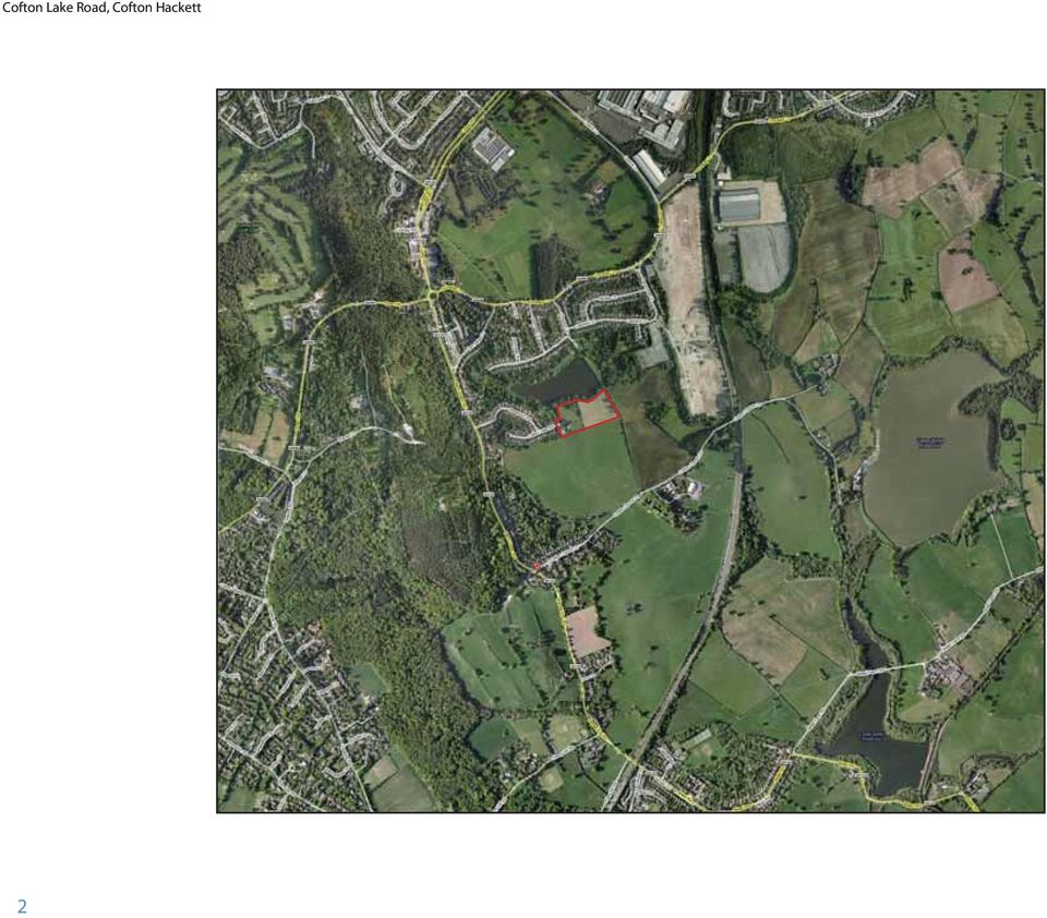
6 Cofton Lake Road, Cofton Hackett Site Location Plan 6

7 Site and Surrounding Area The site is currently situated within the green belt and is located to the east of the Lickey Hills and the Lickey Hills Country Park, on the southern edge of Cofton Hackett which is part of the contiguous urban area. It extends to 2.65 hectares and essentially comprises two parcels of land (three separate fields). The western parcel contains some derelict sheds and areas of mixed scrub whilst the eastern parcel is currently used to graze horses. Trees on the site are very limited in quality and size, with the majority located within the western parcels, or on the site boundaries. The site is accessed off Cofton Lake Road via Reservoir Road and its junction with Barnt Green Road. Further west across Barnt Green Road are the Lickey Hills. The northern boundary between the site and the reservoir is heavily vegetated with tree and shrub planting. The southern boundary of the site follows the line of the rear gardens of the adjacent properties on Cofton Lake Road. There is no public access or rights of away across the site, however the North Worcestershire Long Distance Path runs along the southern boundary, with another public footpath running north-south along the eastern boundary of the site. To the north of the site is a reservoir which is privately owned by local residents. To the north of the reservoir there is existing residential development with Cofton Park and the Longbridge site further the north. From here the Longbridge land arcs around to the east of the site at Cofton Lake Road. Open Countryside exists to the site s eastern boundary. To the west of the site are existing dwellings along Cofton Park Road and Reservoir Road. 7

8 Planning Policy Background The emerging West Midlands Regional Spatial Strategy (RSS) suggests a housing requirement up to 2026 for Bromsgrove District of 2,100 dwellings, with a further possible 3,300 dwellings provided on the edge of Redditch to help meet that Local Authority s housing needs. However, the 2,100 figure (105 dpa) fails to reflect the projected increase in Bromsgrove s households and this has important implications for affordability, something that is currently a significant issue in the District. At the Phase Two Spatial Options stage of the RSS three separate housing requirements were put forward, the third of which was 7,200 and this reflected the 2003 household projections. An analysis of the 2004 household projections suggests there is a need for up to 2026 of 8,240 new dwellings. Clearly the delivery of 105 dwellings per annum is far short of what is actually needed in the District. At the same time it is highly unlikely that Birmingham will be able to satisfy its own requirement over the next 20 years on land within its own boundaries. This is an issue already discussed in Birmingham s emerging Core Strategy 8

9 and the NLP study. Consequently Bromsgrove may be in position whereby it will be delivering as much as 5,000 new homes for Birmingham through development sites on the edge of the conurbation. Cofton Hackett is already part of the contiguous urban area and is shown as being part of the Major Urban Area as defined in the RSS. With the recent approval of the Longbridge Area Action Plan (AAP) the Cofton Hackett/Longbridge areas will see a significant amount of new development and with it considerable sustainability improvements. As well as new housing the AAP will deliver 10,000 jobs together with new retail, commercial, leisure and educational opportunities. All these are not only important elements in bringing these regeneration proposals forward where new residents have access to employment and services and facilities etc but also for the area as a whole. Introducing jobs, shops, education facilities and leisure opportunities enhances the overall sustainability of the southern part of the urban area, including Cofton Hackett. Transport improvements are another important part of these sustainability improvements for the area. This is acknowledged in the APP (Paragraph 3.129) where the importance of various strategic transport proposals and drivers are recognised including the relationship of the APP site to surrounding villages and neighbourhoods (including Frankley, Cofton Hackett and beyond). Therefore the benefits of the Longbridge proposals are wider than simply the AAP area. Whilst the land around Cofton Hackett, including Land at Cofton Lake Road, is currently within the green belt this does not preclude development taking place as part of the plan making process. The Planning White Paper, published in May 2007, states that to ensure that future development takes place in the most appropriate and sustainable locations it is also important that planning authorities should, where appropriate, continue to review Green Belt boundaries when they are drawing up their development plans, as current policy allows them to do, and as has already been undertaken in some areas. Furthermore the RSS Preferred Option document (Paragraph 6.25) is clear that local authorities, in determining the most sustainable form of new development, should consider in their Local Development Documents whether the release of green belt land would provide a more appropriate option than other forms of development. It is therefore wholly appropriate to review the green belt as part of the preparation of the District s Core Strategy. It is considered that the eventual amount of housing which has to be delivered within Bromsgrove District will be greater than that currently proposed. In particular land in the northern part of the District with a strong relationship to the conurbation will need to play an important role in this delivery. Although part of the conurbation there has been little development in Cofton Hackett since the 1950s. The site was originally to be a continuation of the development of Cofton Lake Road and was owned by the same developer. The proposals for the site will now finally complete that development. 9

10 KEY: storey housing reservoir Bungalows Glimpse views of reservoir/ surveillance of POS LEAP Public open space existing footpath 10m landscape buffer Reservoir Reservoir POS (wildlife habitat) 2.5 storey POS (0.5 hectares) LEAP Local equipped area for play Existing public footpaths 2.5 storey 2 storey Potential pedestrian links Existing vegetation taken from aerial photograph (Google Earth) Cofton Lake Road bungalows 10m landscape buffer Path (um) existing footpath Note: Indicative landscape buffer 26 C ft H k tt Total nett developable area 1.3 Ha 39 units indicated based on medium size double fronted detached dwellings with detached single garages producing 30 dph m Copyright Pegasus Planning Group llp. Crown copyright. All rights reserved. Ordnance Survey Copyright Licence number I Promap Licence number Drawings prepared for planning application purposes and can be scaled (drawings are not to be used for construction or sales documents). Please refer to (client) for development design risk assessment documents. Pegasus Urban Design is part of Pegasus Planning Group LLP. Any queries to be reported to Pegasus for Land off Cofton Lake Road, Cofton Hackett - Development Concept Option 1 T F Team MCC/CJH 26 February 2009 drwg. BIR.3085_03/1 I Client: Richborough Estates I 10 Development Concept Plan: Option 1
 57 17 Cofton Lake Road 19 38 21 42 bungalows 10m landscape buffer Path (um) existing")
11 Development Context The two concept plans on pages 10 and 12 illustrate first thoughts on the development at Cofton Lake Road and represents a base from which we welcome further discussions with the Council. Option One Option One is base on a loop road layout, designed to emulate the development in the neighbourhood. A density of 30 dph has been achieved to comply with PPS3. Dwellings to the north have been orientated to capitalise on the glimpse views of the reservoir, while those to the east have been orientated to maximize surveillance of the proposed public open space. An area of existing scrubland has been retained to the north of the site to aid local wildlife habitats, whilst to the east, footpath links to the countryside have been promoted where possible. Bungalow units have been located to the south of the site to reduce the building height and respond to the site s natural topography, thus minimizing the impact on any distant views. Robust landscape buffers are also proposed to the southern and eastern boundaries to provide additional screening, in addition to providing wildlife and conservation values. The south eastern corner of the site is a prominent visual reference in the surrounding landscape that will be retained as Public Open Space and will be carefully designed to minimise visual impact whilst retaining views towards the open countryside. This area could also contain a Local Equipped Area for Play (LEAP). 11

12 KEY: storey housing reservoir Bungalows Glimpse views of reservoir/ surveillance of POS LEAP Public open space existing footpath 10m landscape buffer Reservoir Reservoir LEAP Local equipped area for play POS (0.65 hectares) Existing public footpaths 2.5 storey 2 to 2.5 storey 2 storey Potential pedestrian links Existing vegetation taken from aerial photograph (Google Earth) 21 bungalows Indicative landscape buffer Cofton Lake Road storey 10m landscape buffer Path (um) existing footpath Note: Total nett developable area 1.3 Ha 26 C ft H k tt 39 units producing 30 dph m Copyright Pegasus Planning Group llp. Crown copyright. All rights reserved. Ordnance Survey Copyright Licence number I Promap Licence number Drawings prepared for planning application purposes and can be scaled (drawings are not to be used for construction or sales documents). Please refer to (client) for development design risk assessment documents. Pegasus Urban Design is part of Pegasus Planning Group LLP. Any queries to be reported to Pegasus for Land off Cofton Lake Road, Cofton Hackett - Development Concept Option 2 T F Team MCC/CJH 26 February 2009 drwg. BIR.3085_03/2 I Client: Richborough Estates I 12 Development Concept Plan: Option 2
 21 bungalows Indicative landscape buffer 57 17 Cofton Lake Road 19 38 42 2 storey 10m")
13 Option Two Option Two is an extension of the existing linear culde-sac. Again, a density of 30dph has been achieved to comply with PPS3. Again, bungalow units have been located to the south of the site to respond to the site s natural topography. The majority of the taller housing is strategically placed to the northern side of the site where the ground falls away towards the reservoir, allowing the higher natural topography to the south to screen development. The layout in this area also maximises the filtered views towards the reservoir. Making the small amendment to the green belt required would not result in development being situated any further south than the current boundary at the rear of the properties of Cofton Lake Road. In fact the redevelopment of the Longbridge East Works site will result in new housing projecting further south and as such the Cofton Lake Road site would not be setting any precedent by making a fundamental change to the line of development in this location by pushing the urban area southwards. As with Option One, robust landscape buffers are proposed to the southern and eastern boundaries to provide additional screening, in addition to providing wildlife and conservation values. The south eastern corner of the site is again retained as Public Open Space and will be carefully designed to minimise visual impact whilst retaining views towards the open countryside. This area could also contain a Local Equipped Area for Play (LEAP). 13

14 View from footpath to the south east of the site as it joins Cofton Church Lane. The view looks north west towards the site 14

15 Environmental Considerations Landscape The site is located in the green belt to the east of the Lickey Hills and the Lickey Hills Country Park, on an area of ground to the south of Cofton Hackett. The Site borders Cofton Reservoir to the north, open country side to the east and existing residential dwellings to the west. The site is currently used as horse paddocks and is divided into three separate fields with the remains of out-buildings and garages with the current gated access to the west, remnants of field boundary hedgerows to the centre of the site and a mature hedgerow to the eastern boundary. The northern boundary between the site and the reservoir is heavily vegetated with tree and shrub planting which contrasts with the southern boundary s open character. There is no public access or rights of away across the site, however public footpaths run outside the southern and eastern boundaries. The topography of the area around Cofton Hackett is varied, with the majority of the site sitting on a ridge line at 190m AOD (Above Ordnance Datum) with the ground falling away to the north, east and to the south to approximately 155m AOD (Upper Bittell Reservoir) and 140m AOD (Lower Bittell Reservoir). To the west, the heavily wooded Lickey Hills dominate the landscape at a height of 260m AOD providing elevated views of the surrounding landscape from public footpaths within this area. The character of the area is varied, but generally consists of a rolling landform formed with small irregular fields and areas of heavy woodland. The landscape character of Cofton Hackett itself is one of a heavily landscaped area with mature tree planting within residential areas and particularly along residential streets with Cofton Reservoir at the centre adding to the varied landscape. With regards to any proposals for the site, a sensitive form of development is proposed which is harmonious with the local vernacular and landscape character. Access could be provided from the existing Cofton Lake Road, with the majority of the taller housing strategically placed to the northern side of the site where the ground falls away towards the reservoir, allowing the higher natural topography to the south to screen development. To aid in screening the proposals and to provide additional wildlife and conservation values, a planted landscape buffer could be proposed to the southern and eastern boundaries, which in turn will also aid in tying the development proposals into the existing wider landscape character of Cofton Hackett. The south eastern corner of the site is a prominent visual reference in the surrounding landscape that could be retained as Public Open Space and would be carefully designed to minimise visual impact, whilst retaining views towards the open countryside. Ecology The majority of the site is composed of relatively species-poor grazing paddock. Within the site there are a limited number of mature hedgerows and trees. There are no statutory national, county or district level designations within the site The nearest Site of Special Scientific Interest (SSSI) is situated approximately 1 km to the east of the site (Upper Bittell Reservoir). The Lickey Hills, approximately 0.4km to the west of the site, are designated as a Country Park and inevitably provide ecological benefits. 15

16 View from footpath at south east corner of site looking north west across the site 16

17 As the evidence base for the development proposals is progressed, ecology will be assessed in detail. Any potential for on-site or off-site impacts on flora, fauna and habitats will be investigated. For example, regard will be given to nearby ecological resources such as the adjacent reservoir and whether specific ecological links would be desirable and practicable. Development also has the potential to improve the current limited ecological habitats on the site through the enhancement of the limited vegetation and provision of new areas of open space, which would be managed in an appropriate manner over the long term. Cultural Assets designation is Areas of Ancient and Semi-natural Woodland to the south west of the Site, as part of the Lickey Hills. As part of the redevelopment of the Longbridge site a baseline Archaeology and Cultural Heritage Report was produced; this not only covered the Longbridge site, but also a wider study area, including the site at Cofton Lake Road. The assessment did not report of any archaeological remains or sensitive built cultural heritage within the Cofton Lake Road site. The report concluded that although there are archaeological remains in the area of Longbridge as a whole, there was no issue which presents an obstacle to future redevelopment. low risk of flooding. Due to the size of the site PSS25 requires that a Flood Risk Assessment (FRA) is undertaken. In view of the low risk of flooding this is likely to focus on drainage issues. Surface water from the developed site will, as far as practicable, be managed in a sustainable manner to mimic the surface water flows arising from the site prior to development. The majority of the site is comprised of permeable surfaces; therefore the surface water run-off rate from these new impermeable surfaces will be attenuated to the greenfield run-off rate where possible. These measures could include soakways, control structures, swales etc. and these will be investigated through the FRA. The MAGIC website, an interactive map based resource that contains information on key environmental schemes and designations, as supplied by seven government organisations including English Heritage, has been examined. This shows that there are no Scheduled Ancient Monuments, Listed Buildings, Areas of Ancient Woodland, World Heritage Sites, Conservation Areas, Listed Buildings, Registered Battlefields or Historic Parkland designations within the site or its immediate surrounding area. The nearest Flood Risk and Drainage According to the Environment Agency s (EA s) flood map, the site lies entirely within Flood Zone 1, which is assessed as having a less than 1 in 1000 annual probability of river or sea flooding in any year, where all uses of land are appropriate in this zone (Annex E, Planning Policy Statement 25: Development and Flood Risk). As such the site is at This would ensure that there would be no significant impact on changes in surface water levels and no increase in local flood risk. In many cases the practices that would be followed are designed to minimise the impact on the environment, with scope even for enhancement given the opportunities provided by potential ponds and private gardens for ecological diversification. 17

18 18

19 Transportation Highway Access Access to the proposed development site is from Cofton Lake Road via Reservoir Road and its junction with Barnt Green Road. Richborough Estates has a right of access between the adopted highway and the site boundary. Reservoir Road is some 6.5m in width and, with footways and verge, the total width is 11.4m. Cofton Lake Road is some 5.4m wide plus 2m footways either side of the road. Parking along the route to the site is intermittent, and, as all dwellings have driveways, two-way vehicular access to the site is therefore unimpeded. The level of development proposed will add no more than 30 vehicular trips in any peak hour. That is, no more than one vehicular trip every two minutes in the morning and evening peak hours. The capacity of the access roads to the proposed development is more than sufficient to cater for this additional level of development as is the existing junction with Barnt Green Road. Bus Provision Bus-based public transport is available from bus stops located close to the junction of Barnt Green Road and Reservoir Road. Service 145 links the site with Cotteridge (Kings Norton Station) to the north and Bromsgrove to the south. Other services provide links to Birmingham City centre via Rednal and other local centres to the north, or to Barnt Green, Redditch and Bromsgrove to the south. Some of these services are available at the Barnt Green Road roundabout with Lickey Road. The location of the stops means that bus services in the surrounding area are within walking distance of the site. Rail Provision Rail-based public transport is located at about 2km south from the site at Barnt Green station. The station has parking facilities and therefore offers excellent Park & Ride opportunities for residents of the site. This 2km distance is within the walking and cycling thresholds set out in PPG13 2km and 5km respectively. As PPG13 notes these two distances have the potential to replace short car trips. Barnt Green offers services on the CrossCity line between Redditch and Lichfield, including Birmingham New Street and, via connections to University Station, to Bromsgrove. Only slightly further afield is Longbridge Station, also on the CrossCity line. Cycling A considerable number of services and facilities are available within the 5km PPG13 cycling distance, including, as noted, Barnt Green and Longbridge rail stations. Apart from the social infrastructure refereed to below there are also job opportunities within this distance, including of course the new Longbridge proposals. Walking As noted earlier in this document the North Worcestershire Long Distance Path runs along the southern boundary of the site, with other public rights of way running on the site s eastern boundary and to the south west of the site. As shown on the Concept Plan it is proposed to introduce new pedestrian links to the North Worcestershire path. These will then connect the site directly to the north (Cofton Park and Longbridge) as well as southwards to Cofton Church Lane and westwards to Lickey Hills via the existing residential development on Barnt Green Road. As discussed the site is also within walking distance of public transport provision. 19

20 View from footpath to the south east of the site as it joins Cofton Church Lane. The view looks north west towards the site 20

21 Social Infrastructure The close proximity of the Site to Cofton Hackett and other local centres would encourage sustainable links to existing social provisions and services. For example, 300m to the north of the roundabout of Barnt Green Road with Lickey Road and Rose Hill (approx. 1600m from the site), there is a collection of local retail stores including a newsagents/grocery store, fast food outlets, hairdressers etc. A number of public houses are also located near the roundabout, approximately 1300m from the proposed access to the site. In addition, as discussed previously, the site is well served by public transport, including bus and train provisions, which enable further facilities and services to be accessible to future residents. These include services at local centres such as Barnt Green, Rubery, Selly Oak and Birmingham City centre itself. This ensures job opportunities are within reach of the site, including those at the new Longbridge site to the north. These regular bus and rail services enable further facilities and major employment areas to be within easy reach of the site and encourage the use of more sustainable means of transport rather than relying on the private car. For other journeys however, the site is well located to take advantage of the surrounding highway network, specifically via the M42 which provide quick links to the wider highway network. The site is also well located to take advantage of the outdoor leisure activities offered at the Lickey Hills Country Park, opposite Reservoir Road. Cofton Park to the north of the site, also offers recreation provision. As illustrated on the concept plan, areas of public open space will be provided in addition to a local equipped area for play (LEAP) which could be utilised by the children of the proposed development and other existing residents in the surrounding residential area. 21
22 Conclusion It is the combination of all the factors set out within this document that lead us to believe that we are proposing an appropriate solution to assist Bromsgrove District meet its challenging development requirements and that land at Cofton Lake Road is an appropriate location for future development. As such we invite the Council to discuss this proposal further with us as the preparation of the Core Strategy continues. 22
Site Deliverability Statement Development at: Beech Lane, Kislingbury. Persimmon Homes Midlands March 2015
 Site Deliverability Statement Development at: Beech Lane, Kislingbury Persimmon Homes Midlands March 2015 Contents Site Deliverability Statement Development at: Beech Lane, Kislingbury 1.INTRODUCTION 1.1
Kings Road, Beith. Development Brief. Part 1: Site Specific Information
 Kings Road, Beith Development Brief Part : Site Specific Information Introduction Kings Road is a greenfield site on the north west edge of Beith and is currently let for grazing. The site is roughly rectangular
A new Garden Neighbourhood for West Guildford An opportunity for Smart Growth. university of surrey November 2013
 A new Garden Neighbourhood for West Guildford An opportunity for Smart Growth university of surrey November 2013 A new Garden Neighbourhood for West Guildford Preface Since the County and Borough Councils
DEVELOPMENT BRIEF FOR LAND AT ALLOA ROAD, TULLIBODY
 DEVELOPMENT BRIEF FOR LAND AT ALLOA ROAD, TULLIBODY 1.0 Introduction and Purpose 1.1 Clackmannanshire Council is seeking to dispose of a site at Alloa Road, Tullibody for redevelopment. The site extends
Mount Browne (Surrey Police Head Quarters), Sandy Lane, Guildford Vision Statement. November 2013. with
, Sandy Lane, Guildford Vision Statement. November 2013. with") Mount Browne (Surrey Police Head Quarters), Sandy Lane, Guildford Vision Statement November 2013 with Tibbalds Planning & Urban Design 19 Maltings Place 169 Tower Bridge Road London SE1 3JB Telephone 020
Mount Browne (Surrey Police Head Quarters), Sandy Lane, Guildford Vision Statement November 2013 with Tibbalds Planning & Urban Design 19 Maltings Place 169 Tower Bridge Road London SE1 3JB Telephone 020
1 Welcome. The exhibition comprises a series of boards which provide some background information to show you our initial ideas for the site.
 1 Welcome Thank you for taking the time to attend this public exhibition of our proposals for residential development on Land at Daws Farm, Back Road, Writtle (site shown opposite). The exhibition comprises
Welcome Welcome to the public exhibition for development at Bowman Field. This exhibition provides an overview of the proposals for the site.
 Welcome Welcome to the public exhibition for development at Bowman Field. This exhibition provides an overview of the proposals for the site. Background & Planning Context The Site The site is an area
K M D Hire Services, LONDON ROAD, NANTWICH, CW5 6LU
 Application No: 11/2196N Location: Proposal: Applicant: Expiry Date: K M D Hire Services, LONDON ROAD, NANTWICH, CW5 6LU Extension and New Store Mr Dan Mellor 17-Aug-2011 SUMMARY RECOMMENDATION Approve
COPCUT RISE COPCUT RISE DROITWICH SPA CONSULTATION STATEMENT. November 2010. Prepared by Capita Lovejoy on behalf of William Davis Limited
 COPCUT RISE DROITWICH SPA CONSULTATION STATEMENT COPCUT RISE November 2010 Prepared by Capita Lovejoy on behalf of William Davis Limited Copcut Rise Land north of Copcut Lane, Droitwich Spa: Consultation
Draft New Museums Site Development Framework Supplementary Planning Document SUSTAINABILITY APPRAISAL SCREENING REPORT
 Draft New Museums Site Development Framework Supplementary Planning Document SUSTAINABILITY APPRAISAL SCREENING REPORT MAY 2015 1 Contents 1 INTRODUCTION 3 2 DRAFT NEW MUSEUMS SITE SPD 4 3 STRATEGIC ENVIRONMENTAL
Site Deliverability Statement Alternative Site at: Bridge Road, Old St Mellons
 Site Deliverability Statement Alternative Site at: Bridge Road, Old St Mellons Representor Number 1135 AS(N)4 Persimmon Homes 9 th February 2015 Contents Site Deliverability Statement Alternative Site
Development Layout Design
 Development Layout Design General Design Considerations for Adoptable Highways Version 1 June 2012 Transportation, Waste and Environment Service Issue and Revisions Record Revision Date Originator Purpose
4 Alternatives and Design Evolution
 4 Introduction 4.1 This Chapter describes the considerations and constraints influencing the siting, layout and massing of the Development. It also describes the main alternatives to the Development that
APPLICATION FOR PLANNING PERMISSION FOR A SOIL TREATMENT FACILITY AT KINGS CLIFFE LANDFILL SITE, STAMFORD, NORTHAMPTONSHIRE
 APPLICATION FOR PLANNING PERMISSION FOR A SOIL TREATMENT FACILITY AT KINGS CLIFFE LANDFILL SITE, STAMFORD, NORTHAMPTONSHIRE DESIGN AND ACCESS STATEMENT Report Reference: AU/KC/SPH/1449/01/D&A/FIN Baddesley
Carmarthenshire LDP Site Assessment Proforma
 Carmarthenshire LDP Site Assessment Proforma 1. Site Details Ref: SC1/h1 Site Ref (where applicable): Location: Parc Puw, Drefach Felindre Site Area (Ha): Eisting Use* *if candidate site as proposed by
Key Facts. Passenger growth at the airport is projected to grow to approximately 3 million passengers per annum by 2030.
 Bournemouth Airport & Business Park 7 7 Bournemouth Airport & Business Park Introduction 7.1 Bournemouth Airport is a key asset for the region, one of the UK s fastest growing regional airports and is
3.0 Planning Policies
 3.0 Planning Policies 3.1 National Policy 3.1.1 Government Planning Policy Guidance Notes (PPGs), and Planning Policy Statements (PPSs) provide the background to most aspects of the planning system. The
Site Deliverability Statement Development at: Bridgnorth Road, Much Wenlock. Persimmon Homes October 2013
 Site Deliverability Statement Development at: Bridgnorth Road, Much Wenlock Persimmon Homes October 2013 Contents Site Deliverability Statement Development at: Bridgnorth Road, Much Wenlock. 1.INTRODUCTION
Earls Court Farm Worcester
 Earls Court Farm Worcester LOCAL DEVELOPMENT FRAMEWORK www.worcestercitycouncil.gov.uk SUPPLEMENTARY PLANNING DOCUMENT Earls Court Farm Development & Design Brief SPD FEBRUARY 07 4 2 Site-Context
10.1 WILL HEY FARM WATFORD LANE NEW MILLS RETENSION OF NEW STABLE BLOCK, SAND PADDOCK AND ASSOCIATED EARTHWORKS AND LANDSCAPING (FULL - MINOR)
") HPK/2012/0207 03/04/2012 WILL HEY FARM WATFORD LANE NEW MILLS MR & MRS M WILSON KIRSTY WILSON EQUINE AND WILL HEY FARM BED & BREAKFAST RETENSION OF NEW STABLE BLOCK, SAND PADDOCK AND ASSOCIATED EARTHWORKS
HPK/2012/0207 03/04/2012 WILL HEY FARM WATFORD LANE NEW MILLS MR & MRS M WILSON KIRSTY WILSON EQUINE AND WILL HEY FARM BED & BREAKFAST RETENSION OF NEW STABLE BLOCK, SAND PADDOCK AND ASSOCIATED EARTHWORKS
Councillor R. Hollingworth has requested that this application be considered by the Committee, rather than being determined under delegated powers.
 Name of Applicant Type of Certificate Proposal Map/Plan Policy Plan Date Mr Timothy D. Hosking A Proposed extension to form bespoke living accommodation for disabled family member (As augmented by information
Development proposals will require to demonstrate, according to scale, type and location, that they:-
 Appendix 2 : Relevant Development Plan Policies Angus Local Plan Review 2009 Policy S1 : Development Boundaries (a) Within development boundaries proposals for new development on sites not allocated on
Glossop Design & Place Making Strategy
 Supplementary Planning Document to the High Peak Local Plan June 2011 Design Brief for the Town Hall Complex GILLESPIES I GERALD EVE Reproduced from the Ordnance Survey map with the permission of Ordnance
On the instruction of Ros Goode & Roland Morgan, Joint Fixed Charge Receivers
 FOR SALE On the instruction of Ros Goode & Roland Morgan, Joint Fixed Charge Receivers Land at Teville Gate, Teville Road, Worthing, West Sussex BN11 1AZ ibrochure - www.cbre-ibrochure.co.uk/worthing ENTER
21.03 SETTLEMENT AND HOUSING
 21.03 SETTLEMENT AND HOUSING 09/10/2014 C187Prop osed C189 21.03-1 Housing 09/10/2014 C187 This clause provides local content to support Clause 11 (Settlement) and 15 (Built Environment and Heritage) and
Relevant Planning History P/2006/1070: Demolition of building and construction of supermarket and 14 2 bed flats. Withdrawn.
 P/2010/1404/MPA St Marychurch Ward Former G A Insurance Buildng, Greenway Road/St Marychurch Road, St Marychurch Torquay Demolition of former G A building; formation of up to 7 retail units for purposes
Development Brief Erskine Lodge Site, Great Whelnetham
 Development Brief Erskine Lodge Site, Great Whelnetham Development Brief Contents 1.0 Introduction 2.0 Site Context 3.0 Development Constraints 4.0 Whelnetham Context Analysis 5.0 Development Opportunities
FLOOD RISK AND SURFACE WATER DRAINAGE ASSESSMENT HILLHOUSE RESTORATION SITE, OFF JAMESON ROAD, THORNTON CLEVELEYS ON BEHALF OF NPL ESTATES
 FLOOD RISK AND SURFACE WATER DRAINAGE ASSESSMENT HILLHOUSE RESTORATION SITE, OFF JAMESON ROAD, THORNTON CLEVELEYS ON BEHALF OF NPL ESTATES Integra Consulting Engineers Limited NS / 2543 Fountain House
Supplementary Planning Document. Radlett. District Centre Key Locations. Planning brief. March 2011. Hertsmere Borough Council
 Supplementary Planning Document Radlett District Centre Key Locations Planning brief March 2011 Hertsmere Borough Council Large print and languages Hertsmere Borough Council aims to provide information
Shannon Corner Service Centre, 208-212 Burlington Road, New Malden, KT3 4NP
 Shannon Corner Service Centre, 08-1 Burlington Road, New Malden, KT NP S1 Total site area (ha) 0.05ha Current MOT Car Repair Undeveloped land (ha) 0 Number of units 1 Grid reference TQ 680 Sequential status
K M D Hire Services, LONDON ROAD, NANTWICH, CW5 6LU
 Application No: 11/2196N Location: Proposal: Applicant: Expiry Date: K M D Hire Services, LONDON ROAD, NANTWICH, CW5 6LU Extension and New Store Mr Dan Mellor 17-Aug-2011 SUMMARY RECOMMENDATION Approve
LANDSCAPE AND DEVELOPMENT CHECKLIST FOR MONMOUTHSHIRE COUNTY COUNCIL
 LANDSCAPE AND DEVELOPMENT CHECKLIST FOR MONMOUTHSHIRE COUNTY COUNCIL 1 Introduction It is to the advantage of the developer to treat the environmental aspects of development proposals seriously and take
AGRICULTURAL BUILDING WITH PHOTOVOLTARIC SOLAR PANELS TO SOUTH FACING ROOF
 DC/2015/00494 AGRICULTURAL BUILDING WITH PHOTOVOLTARIC SOLAR PANELS TO SOUTH FACING ROOF LAND AT ONEN, ADJACENT TO B4233, NP25 5EN. RECOMMENDATION: APPROVE Case Officer: Elizabeth Bennett Date Registered:
LEWES DISTRICT AND SOUTH DOWNS NATIONAL PARK AUTHORITY LEWES DISTRICT JOINT CORE STRATEGY INDEPENDENT EXAMINATION
 1 LEWES DISTRICT AND SOUTH DOWNS NATIONAL PARK AUTHORITY LEWES DISTRICT JOINT CORE STRATEGY INDEPENDENT EXAMINATION STATEMENT BY CROUDACE STRATEGIC LIMITED ISSUES 7 AND 8 STRATEGIC SITES (POLICIES SP5/SP6)
CHANGE OF USE FROM AGRICULTURE TO A USE FOR CARAVAN STORAGE COMPOUND AND OPERATIONAL DEVELOPMENT.
 2014/1898 BIRMINGHAM ROAD MERIDEN Application No: Ward/Area: Location: 2014/1898/S MERIDEN BIRMINGHAM ROAD MERIDEN Date Registered: 21/11/2014 Applicant: Proposal: MR VAUGHN WILLIAMS CHANGE OF USE FROM
FLOOD RISK STATEMENT IN SUPPORT OF THE CONNECTING HERNE BAY AREA ACTION PLAN PREFERRED OPTIONS DOCUMENT
 FLOOD RISK STATEMENT IN SUPPORT OF THE CONNECTING HERNE BAY AREA ACTION PLAN PREFERRED OPTIONS DOCUMENT Canterbury City Council January 2008 1 APPLICATION OF THE PPS25 SEQUENTIAL AND EXCEPTION TESTS 1.0
Taylor Wimpey UK Ltd. December 2007
 Taylor Wimpey UK Ltd December 2007 QM Issue/revision Issue 1 Revision 1 Revision 2 Revision 3 Remarks Draft For Planning Date 3 August 2007 20 December 2007 Prepared by D Gooding P Barton Signature Checked
Stowmarket Area Action Plan (AAP) Examination
 Examination") Stowmarket Area Action Plan (AAP) Examination Main Matters, Issues and Questions Matter 3 - Employment (Appendix) This contains additional information in support of the Hearing Statement and relates to
Stowmarket Area Action Plan (AAP) Examination Main Matters, Issues and Questions Matter 3 - Employment (Appendix) This contains additional information in support of the Hearing Statement and relates to
The Northumberland Estates Proposed Residential Development, Prudhoe Town Centre D/I/D/63558/603. Framework Residential Travel Plan
 The Northumberland Estates Proposed Residential Development, Prudhoe Town Centre D/I/D/63558/603 Framework Residential Travel Plan September 2013 CONTROL SHEET CLIENT: PROJECT TITLE: REPORT TITLE: THE
Site Proposal 15. suitable modern space. The design of any proposals will need to be sensitive to the railway line.
 Site Proposal 15 West Barnes Library West Barnes Lane, 10 Station Road, New Malden, Surrey, KT3 6JJ Site area Site description 0.1ha Single storey building tucked away behind Motspur Park station. To the
Coventry Development Plan 2016 Appendix 89. Glossary of Key Terms
 Coventry Development Plan 2016 Appendix 89 Glossary of Key Terms Area Action Plan A Development Plan Document which focuses upon a specific location or an area subject to significant change. Affordable
KINGSTON TOWN PLANNING SUB-COMMITTEE 23 MARCH 2005. YELLOW BOX STORAGE 163-165, LONDON ROAD AND 50, GORDON ROAD, Application Number: 05/12156
 APPENDIX C KINGSTON TOWN PLANNING SUB-COMMITTEE 23 MARCH 2005 YELLOW BOX STORAGE 163-165, LONDON ROAD AND 50, GORDON ROAD, Application Number: 05/12156 REPORT BY HEAD OF PLANNING AND DEVELOPMENT SUMMARY
28.0 Development Permit Area #2 (Neighbourhood District)
") 28.0 Development Permit Area #2 (Neighbourhood District) Goals and Objectives To provide a guide for infill and new development in the Neighbourhood District. To outline the nature, form and character
28.0 Development Permit Area #2 (Neighbourhood District) Goals and Objectives To provide a guide for infill and new development in the Neighbourhood District. To outline the nature, form and character
march 2011 development framework boscomoor lane Inglewood Investment Company Limited
 boscomoor lane development framework march 2011 Inglewood Investment Company Limited contents 1.0 2.0 3.0 4.0 5.0 6.0 7.0 8.0 executive summary introduction development plan context green belt site context
LONDON ROAD SEVENOAKS
 WELCOME TO THE BERKELEY HOMES EXHIBITION Train Station Gr anv i ll e Dar tford Road Lo ad Ro nd on ad Ro Eard SITE Th ed riv e ley R oad on R oad A 224 Gord Pem b rok e Roa d Site Location Since the submission
Development Brief for the Gedling Colliery and Chase Farm site
 Development Brief for the Gedling Colliery and Chase Farm site Contents 1. Introduction 2. The Site 3. Planning Policy Context 4. Development Requirements Figures 1. Site Location 2. Gedling Access Road
Department of State Development, Infrastructure and Planning. State Planning Policy state interest guideline. State transport infrastructure
 Department of State Development, Infrastructure and Planning State Planning Policy state interest guideline State transport infrastructure July 2014 Great state. Great opportunity. Preface Using this state
BASILDON BOROUGH COUNCIL
 BASILDON BOROUGH COUNCIL Report to: Planning Committee December 05 PLANNING APPLICATION NO. 5/00699/FULL DEMOLITION OF ALL EXISTING OUTBUILDINGS AND REMOVAL OF ASSOCIATED LAWFUL USES AND TWO NO. RESIDENTIAL
Sustainability Appraisal of the Lichfield Local Plan: Strategy
 Lichfield District Council Sustainability Appraisal of the Lichfield Local Plan: Strategy Post Adoption Statement February 2015 U R S U S C O N S U L T I N G L T D Quality Management URSUS Consulting Ltd
WELCOME PROPOSALS FOR PENTAVIA RETAIL PARK WELCOME TO OUR EXHIBITION WHICH SETS OUT OUR PLANS TO DEVELOP THE PENTAVIA RETAIL PARK SITE.
 WELCOME WELCOME TO OUR EXHIBITION WHICH SETS OUT OUR PLANS TO DEVELOP THE PENTAVIA RETAIL PARK SITE. The purpose of the exhibition is to provide the community with the opportunity to view our initial ideas
Development Management Officer Report Committee Application. Summary
 Development Management Officer Report Committee Application Summary Committee Meeting Date: 15 Dec 2015 Item Number: Application ID: Z/2014/0978/F Target Date: 31 st October 2014 Proposal: Single storey
Richmond upon Thames College. Draft Planning Brief. May 2008
 Richmond upon Thames College Draft Planning Brief May 2008 1. Introduction 1.1 The purpose of this Planning Brief is to establish a development framework for the proposed comprehensive redevelopment of
AMENDED OUTLINE DEVELOPMENT PLAN, VILLAGE DOCKLANDS PRECINCT, 2-46 BATMANS HILL DRIVE, DOCKLANDS
 Page 1 of 22 PLANNING COMMITTEE REPORT Agenda Item 5.7 AMENDED OUTLINE DEVELOPMENT PLAN, VILLAGE DOCKLANDS PRECINCT, 2-46 BATMANS HILL DRIVE, DOCKLANDS 7 August 2007 Division Sustainability & Regulatory
Corridor Goals and Objectives
 Corridor Goals and Objectives This chapter presents the goals and objectives, developed by the Corridor Study Committee, that serve as the purpose and intent of the Corridor Plan. This plan covers a twenty
Recommendations for future developments
 C Recommendations for future developments C.1 Reducing flood risk through site layout and design C.1.1 C.1.2 Flood risk should be considered at an early stage in deciding the layout and design of a site
SCHEDULE 16 TO THE SPECIAL USE ZONE. Shown on the planning scheme map as SUZ16. BALLARAT RAILWAY STATION PRECINCT. Purpose
 SCHEDULE 16 TO THE SPECIAL USE ZONE Shown on the planning scheme map as SUZ16. BALLARAT RAILWAY STATION PRECINCT Purpose To facilitate the revitalisation of the Ballarat Station Precinct in accordance
Council, Municipal Building, Kingsway, Widnes, Cheshire, WA8 7QF. Greenspace. DEVELOPMENT PLAN ALLOCATION:
 APPLICATION NO: LOCATION: PROPOSAL: WARD: PARISH: CASE OFFICER: AGENT(S) / APPLICANT(S): DEVELOPMENT PLAN ALLOCATION: 13/00397/HBCOUT Land at Widnes Recreation Ground, Liverpool Road, Widnes, Cheshire.
CHARACTER TYPE 15 RAISED FRINGE SETTLEMENT
 CHARACTER TYPE 15 RAISED FRINGE SETTLEMENT Character Area: Grange Park (15 RFS 1) Mossbank (15 RFS 2) Derbyshire Hill / Parr (15 RFS 3) Sutton (15 RFS 4) Key Characteristics settled areas located on raised
OVERARCHING SPATIAL POLICIES
 3 OVERARCHING SPATIAL POLICIES 29 Overarching Spatial Policies 3.1 This chapter contains policies addressing the following policy themes: OSP 1: Optimising growth OSP 2: Land use OSP 3: Connections and
Planning and Listed Building Consent Applications for the retention of a fence, to part of the perimeter to Gayton Hall, Gayton, Wirral.
 Planning and Listed Building Consent Applications for the retention of a fence, to part of the perimeter to Gayton Hall, Gayton, Wirral. Planning, Design and Access Statement August 2009 Taylor Young /
Stones Farm, Sittingbourne Development Brief. Adopted by Swale Borough Council 3rd May 2011
 Stones Farm, Sittingbourne Development Brief Adopted by Swale Borough Council 3rd May 2011 G H Dean & Co, and St John s College, Cambridge Prepared by Paul Sharpe Associates LLP and Consultant Team For
Advice can also be sought from specific specialist officers in the Council.
 Canterbury City Council Validation of Planning Applications Guidance note 2010: Introduction Up to date advice on the validation of planning applications is contained in the CLG Guidance on information
The land is allocated within the Westbury on Trym Conservation Area and the land is protected by a blanket TPO 340.
 SITE DESCRIPTION The site is occupied by a large single dwelling house which was built in 2007. The building is surrounded by large trees and has a substantial rear garden. The land is allocated within
approval of matters specified in conditions; and The Town and Country Planning (Development Management Procedure) (Scotland) Regulations 2013
 (Scotland) Regulations 2013") Application for: planning permission; planning permission in principle; further applications; approval of matters specified in conditions; and mineral workings (if the planning authority do not have a
Application for: planning permission; planning permission in principle; further applications; approval of matters specified in conditions; and mineral workings (if the planning authority do not have a
Site Alternative Deliverability Report. SALT 034 Ty Nant, Groesffordd Resubmission: Deliverable. Local Development Plan
 Local Development Plan Site Alternative Deliverability Report Brecon Beacons National Park Authority SALT 034 Ty Nant, Groesffordd Resubmission: Deliverable SALT 034 Ty Nant Groesffordd (Llanfrynach) Existing
Site Assessment for Neighbourhood Plans: A toolkit for neighbourhood planners
 Site Assessment for Neighbourhood Plans: A toolkit for neighbourhood planners Action the COI Table Of Contents Introduction... 3 Benefit of carrying out a site assessment... 4 How to carry out a site assessment
Gold Property Developments welcomes you to this exhibition of the draft plans for the regeneration of the Holborn Studios site on Eagle Wharf Road.
 WELCOME Gold Property Developments welcomes you to this exhibition of the draft plans for the regeneration of the Holborn Studios site on Eagle Wharf Road. The site covers approximately 0.37 hectares and
Planning should achieve high quality urban design and architecture that: Contributes positively to local urban character and sense of place.
 15 BUILT ENVIRONMENT AND HERITAGE 15/07/2013 VC100 Planning should ensure all new land use and development appropriately responds to its landscape, valued built form and cultural context, and protect places
DESIGN AND ACCESS STATEMENT
 CHANGE OF USE OF EXISTING RESIDENTIAL ANNEXE TO A SEPARATE DWELLING AND CONSTRUCTION OF A NEW WALL FENCE AND GATES AT LITTLE NOOKE CHAPEL LANE WYRE PIDDLE PERSHORE WORCESTERSHIRE WR10 2JA 1.0 INTRODUCTION
Report to Planning applications committee Item Date 6 March 2014 Head of planning services
 Report to Planning applications committee Item Date 6 March 2014 Report of Head of planning services 4(7) Subject 13/02051/F Former Wellesley First School Wellesley Avenue North Norwich NR1 4NT Description:
Welcome. Thank you for taking the time to attend today. The Team. www.thehousemaker.co.uk
 Welcome Thank you for taking the time to attend today The purpose of the exhibition is to share with the local community the draft proposals to develop the former TA Centre site and adjoining private open
The Green Belt A Guide for Householders
 The Green Belt A Guide for Householders Introduction Much of Mole Valley lies within the Metropolitan Green Belt. This leaflet outlines the purpose, importance and characteristics of the Green Belt and
05 AREA/SITE SPECIFIC GUIDELINES
 05 AREA/SITE SPECIFIC GUIDELINES Site 1 - Glass Yard The leisure centre that is currently located on this site should move to a more central location in the town centre close to the existing public squares.
AGENT(S) / APPLICANT(S): AGENT Dave Dickerson, DK Architects. APPLICANT Halton Housing Trust. DEVELOPMENT PLAN ALLOCATION: Greenspace.
 / APPLICANT(S): AGENT Dave Dickerson, DK Architects. APPLICANT Halton Housing Trust. DEVELOPMENT PLAN ALLOCATION: Greenspace.") APPLICATION NO: 14/00168/FUL LOCATION: Land to the west of 19 Crow Wood Lane, Widnes. PROPOSAL: Proposed erection of 10 no. 1 bedroom apartments with individual access doors arranged in 2no. 2 storey height
APPLICATION NO: 14/00168/FUL LOCATION: Land to the west of 19 Crow Wood Lane, Widnes. PROPOSAL: Proposed erection of 10 no. 1 bedroom apartments with individual access doors arranged in 2no. 2 storey height
Charging for Pre-application Advice. WSCC Guidance Note
 Charging for Pre-application Advice WSCC Guidance Note Content 1. Introduction 1.1 Our Objectives 1.2 Development Team Approach 1.3 Areas of Advice 1.4 What We Expect of You 1.5 Benefits of Pre-application
4.4 ECOCITY Tampere - Vuores
 4.4 ECOCITY Tampere - Vuores Figure 4.4.1 Location of the Vuores area 4.4.1 General information The Vuores case area is a typical greenfield development in a woodland area to the south of the city of Tampere.
DEPARTMENT OF TRANSPORT CYCLING STRATEGY 29 February 2008
 DEPARTMENT OF TRANSPORT CYCLING STRATEGY 29 February 2008 INTRODUCTION The Department of Transport s Business Plan for the 2007/08 financial year stated the following: Government Aim: Quality Environment
Chapter 12: Impacts, Mitigation, Cumulative Impacts and Residual Effects
 Chapter 12: Impacts, Mitigation, Cumulative Impacts and Residual Effects REnescience Northwich Quality Management Prepared by: Tom Dearing Senior Environmental Consultant 02/10/15 Reviewed & checked by:
Householder Applications: Supplementary Planning Guidance GENERAL POINTS
 Householder Applications: Supplementary Planning Guidance Environment Committee: 28 January 2004 Chief Planning Officer Town Hall The Parade Epsom Surrey KT18 5BY tel 01372 732000 web www.epsom-ewell.gov.uk
Guidance on Householder permitted development rights
 FORWARD CONTENTS CLOSE Guidance on Householder permitted development rights Circular 1/2012 CONTENTS BACK FORWARD CLOSE 1. INTRODUCTION 04 2. BEFORE STARTING 05 3. MAIN CONCEPTS 07 Principal elevation
New housing, settlement expansion and the natural heritage
 COMMISSIONED REPORT Commissioned Report No. 120 New housing, settlement expansion and the natural heritage (ROAME No. F04AA501) For further information on this report please contact: Alan Fay or Richard
Department for Communities and Local Government
 Department for Communities and Local Government Permitted development for householders Technical Guidance April 2014 Department for Communities and Local Government Please note: This technical guidance
Proposed Heavy Equipment (Nortrax) Sales & Service Facility
 Sales & Service Facility") Proposed Heavy Equipment (Nortrax) Sales & Service Facility 130 David Manchester Road Planning Rationale Prepared by: McIntosh Perry Consulting Engineers Ltd. 115 Walgreen Road Carp, ON K0A 1L0 July 2013
Proposed Heavy Equipment (Nortrax) Sales & Service Facility 130 David Manchester Road Planning Rationale Prepared by: McIntosh Perry Consulting Engineers Ltd. 115 Walgreen Road Carp, ON K0A 1L0 July 2013
9.0 Alta Vista/Faircrest Heights/Riverview Park (Key Principles)
") 9.0 Alta Vista/Faircrest Heights/Riverview Park (Key Principles) Official Plan Consolidation for the City of Ottawa 1 9.1 Location This Chapter applies to Alta Vista/Faircrest/Riverview Park, which corresponds
9.0 Alta Vista/Faircrest Heights/Riverview Park (Key Principles) Official Plan Consolidation for the City of Ottawa 1 9.1 Location This Chapter applies to Alta Vista/Faircrest/Riverview Park, which corresponds
Site Alternative Deliverability Report. SALT 033 Former Mid Wales Hospital, Talgarth Resubmission: Undeliverable. Local Development Plan
 Local Development Plan Site Alternative Deliverability Report Brecon Beacons National Park Authority SALT 033 Former Mid Wales Hospital, Talgarth Resubmission: Undeliverable SALT 033 Former Mid Wales Hospital
Development Management Report
 Committee and Date Central Planning Committee 5 th April 2012 Item 13 Public Development Management Report Responsible Officer: Stuart Thomas email: [email protected] Tel: 01743 252665 Fax:
Draft Goals and Objectives Wadena Comprehensive Plan City of Wadena, Minnesota. Land Use Goals:
 Draft Goals and Objectives Wadena Comprehensive Plan City of Wadena, Minnesota Land Use Goals: 1. Growth in Wadena will be undertaken in such a manner as to create a full range of living, working, shopping,
Site Specific Policies
 Local Development Framework Site Specific Policies Development Plan Document 03450 450 500 www.scambs.gov.uk Local Development Framework Site Specific Policies Development Plan Document Published by South
1 & 2 Brooklyn Cottages, Portsmouth Road, Bursledon, Southampton, SO31 8EP
 BURSLEDON, HAMBLE-LE-RICE & HOUND Thursday 02 February 2006 Case Officer Rachel Illsley SITE: & 2 Brooklyn Cottages, Portsmouth Road, Bursledon, Southampton, SO3 8EP Ref. F/05/55659 Received: 24//2005
DENSITY AND PUBLIC SPACE AT BISHOP STREET
 DENSITY AND PUBLIC SPACE AT BISHOP STREET Niehoff Urban Studio Senior Planning Capstone Spring 2015 Justin M. Lightfield U N I V E R S I T Y O F C I N C I N N A T I Table of Contents Overview... 3 Design
VALIDATION REQUIREMENTS FOR PLANNING APPLICATIONS
 Planning Services, Civic Offices, New Road, Grays, Essex RM17 6SL VALIDATION REQUIREMENTS FOR PLANNING APPLICATIONS Checklists to ensure prompt validation: Checklist 1 for ALL applications for planning
KENCOT HILL SOLAR PARK, OXFORDSHIRE PLANNING BRIEFING DOCUMENT. on behalf of MR TAD CZAPSKI FEBRUARY 2011
 KENCOT HILL SOLAR PARK, OXFORDSHIRE PLANNING BRIEFING DOCUMENT on behalf of MR TAD CZAPSKI FEBRUARY 2011 Prepared by: ROBINSON & HALL LLP Land & Property Consultants 118 Bromham Road Bedford MK40 2QN 01234
LOCAL MEMBERS COMMENTS APPLICATION NO: 06/2060/W DATE RECEIVED: 08/09/2006
 COMMITTEE DATE: 17/01/2006 LOCAL MEMBERS COMMENTS APPLICATION NO: 06/2060/W DATE RECEIVED: 08/09/2006 ED: APP: TYPE: APPLICANT: LOCATION: PROPOSAL: WHITCHURCH/TONGWYNLAIS Full Planning Permission Orbis