Western States Water Council and California Department of Water Resources
|
|
|
- Gloria Garrett
- 7 years ago
- Views:
Transcription
1 Western States Water Council and California Department of Water Resources Improving Forecasting Weather to Climate Time Scales May 27, 2012 Roger V. Pierce Meteorologist -in- Charge National Weather Service Forecast Office San Diego CA

2
3 Mission- to provide forecasts and warnings: The protection of life and property The enhancement of the national economy The NWS is the official voice for issuing forecasts and warnings during life-threatening weather. Zero to 7 days in advance (10 in discussion)

4 NOAA National Weather Service
5 San Diego Forecast and Warning Area
6 Meteorological Forecasting Focus not just on San Diego but California and the west Great opportunity to work with DWR and WSWC 0 10 days / NWS Climate Prediction Center 10 days and beyond
7 Images for Extreme Weather
8 Extremes in the West
9 Extremes Forecasts
10 How Do We Improve Forecasts? People People People Science Communications Training Data Data Data Instruments Sensors Satellites Computers Computers Computers Time Comms Programming
11 Scale / Forecast Funnel Global picture large scale global storms and how they will impact your individual area Continental Picture / United States and adjacent waters Western US and Eastern Pacific area SoCal - coastal waters / AZ / NV Mesoscale mountains/passes/coastal zones
12 Scale / Forecast Funnel Start with a global picture. Satellites Yes there is more than just satellite data: Balloons sounding data Aircraft data Profilers Surface based observations airports / ship reports Buoys - Mesonet data for great localized surface data
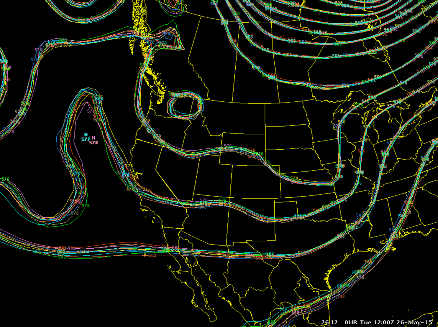
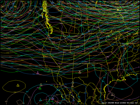
13 05/26/15 4:00 PM
14 05/26/15 11:00 Visible AM Image - 12/04/12 2PM PST
15 Radiosonde Launch
16

17 Commercial Aircraft Observation
18 Standard - Aviation Surface Observation System
19
20

21
22
23

24 WSR-88D Sacramento Radar on Friday at about 10 am. Red s and bright yellows indicating heavy rainfall.
25 Other Data MesoWest University of Utah citizen weather observers to corporate weather observing companies with surface data user beware. GPS Water Vapor Unmanned Areal Systems Hurricane Hunter Aircraft COOP Data

26 Numerical Weather Models
27
28

29 24 hour Quantitative Precipitation Forecast

30

31
32 Pattern Recognition

33 Pattern Recognition
34
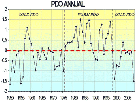
35 Longer Period Forecasts Oceanography sea surface temperatures Global circulation patterns Modern era measurements ie. outgoing longwave radiation Pattern recognition on a monthly to decadal scale Trend analysis Generalizations in forecasting and skill
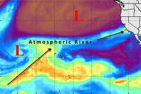
36 Major goal: Measure influx of moisture to California from landfalling atmospheric rivers and study the influence of transported (cross Pacific) or local (Central Valley) aerosols on precipitation from the coast to Sierra Evolution and structure of ARs, including quantifying terms in the water vapor transport budget (air-sea flux, rainout, frontal convergence, entrainment from tropics) Prediction of aerosols and properties during intercontinental transport to the U.S. West Coast, including dust, biological and ice nuclei Effects of climate variability and change on these phenomena
37 What does your customer want? Match the desires of the customer to the science Improve the science - Infuse new technology - Improve products Private Public Partnerships
38 U.S. point and click weather - San Diego point and click NWS National Centers for Environmental Prediction -longer range forecasts Climate Prediction Center -shorter range forecasts Weather Prediction Center
39 Madden-Julian Oscillation

40 Outgoing Longwave Radiation
41 North Atlantic Oscillation Lisbon, Portugal and Stykkisholmur/Reykjavik, Iceland Azores high and the Icelandic low

42 Pacific Decadal Oscillation
43 Nov 2002 El Nino
44 Nov 2007 La Nina
45 What does your customer want? Match the desires of the customer to the science Improve the science - Infuse new technology - Improve products Private Public Partnerships
46 U.S. point and click weather - San Diego point and click NWS National Centers for Environmental Prediction -longer range forecasts Climate Prediction Center -shorter range forecasts Weather Prediction Center
[ Climate Data Collection and Forecasting Element ] An Advanced Monitoring Network In Support of the FloodER Program
![[ Climate Data Collection and Forecasting Element ] An Advanced Monitoring Network In Support of the FloodER Program](/thumbs/33/16326315.jpg "[ Climate Data Collection and Forecasting Element ] An Advanced Monitoring Network In Support of the FloodER Program") [ Climate Data Collection and Forecasting Element ] An Advanced Monitoring Network In Support of the FloodER Program December 2010 1 Introduction Extreme precipitation and the resulting flooding events
[ Climate Data Collection and Forecasting Element ] An Advanced Monitoring Network In Support of the FloodER Program December 2010 1 Introduction Extreme precipitation and the resulting flooding events
Forecast-Informed Reservoir Operations: A Concept Supporting Water Supply and Flood Control
 16 inches of rain in 1 day in Central California Forecast-Informed Reservoir Operations: A Concept Supporting Water Supply and Flood Control Developed by the Center for Western Weather and Water Extremes
Improved Warnings for Natural Hazards: A Prototype System for Southern California
 Improved Warnings for Natural Hazards: A Prototype System for Southern California Yehuda Bock Research Geodesist Scripps Institution of Oceanography University of California San Diego, La Jolla, Calif.
ARkStorm: California s Other Big One!
 ARkStorm: California s Other Big One! Understanding the Impacts of Massive Winter Storms Mark Jackson Meteorologist in Charge NOAA/National Weather Service Los Angeles/Oxnard What is ARkStorm? Emergency-preparedness
ENSO Cycle: Recent Evolution, Current Status and Predictions. Update prepared by Climate Prediction Center / NCEP 9 May 2011
 ENSO Cycle: Recent Evolution, Current Status and Predictions Update prepared by Climate Prediction Center / NCEP 9 May 2011 Outline Overview Recent Evolution and Current Conditions Oceanic Niño Index (ONI)
2. The map below shows high-pressure and low-pressure weather systems in the United States.
 1. Which weather instrument has most improved the accuracy of weather forecasts over the past 40 years? 1) thermometer 3) weather satellite 2) sling psychrometer 4) weather balloon 6. Wind velocity is
ENSO: Recent Evolution, Current Status and Predictions. Update prepared by: Climate Prediction Center / NCEP 29 June 2015
 ENSO: Recent Evolution, Current Status and Predictions Update prepared by: Climate Prediction Center / NCEP 29 June 2015 Outline Summary Recent Evolution and Current Conditions Oceanic Niño Index (ONI)
IGAD CLIMATE PREDICTION AND APPLICATION CENTRE
 IGAD CLIMATE PREDICTION AND APPLICATION CENTRE CLIMATE WATCH REF: ICPAC/CW/No.32 May 2016 EL NIÑO STATUS OVER EASTERN EQUATORIAL OCEAN REGION AND POTENTIAL IMPACTS OVER THE GREATER HORN OF FRICA DURING
Jessica Blunden, Ph.D., Scientist, ERT Inc., Climate Monitoring Branch, NOAA s National Climatic Data Center
 Kathryn Sullivan, Ph.D, Acting Under Secretary of Commerce for Oceans and Atmosphere and NOAA Administrator Thomas R. Karl, L.H.D., Director,, and Chair of the Subcommittee on Global Change Research Jessica
Observed Cloud Cover Trends and Global Climate Change. Joel Norris Scripps Institution of Oceanography
 Observed Cloud Cover Trends and Global Climate Change Joel Norris Scripps Institution of Oceanography Increasing Global Temperature from www.giss.nasa.gov Increasing Greenhouse Gases from ess.geology.ufl.edu
Climate Models: Uncertainties due to Clouds. Joel Norris Assistant Professor of Climate and Atmospheric Sciences Scripps Institution of Oceanography
 Climate Models: Uncertainties due to Clouds Joel Norris Assistant Professor of Climate and Atmospheric Sciences Scripps Institution of Oceanography Global mean radiative forcing of the climate system for
Joint Polar Satellite System (JPSS)
") Joint Polar Satellite System (JPSS) John Furgerson, User Liaison Joint Polar Satellite System National Environmental Satellite, Data, and Information Service National Oceanic and Atmospheric Administration
Joint Polar Satellite System (JPSS) John Furgerson, User Liaison Joint Polar Satellite System National Environmental Satellite, Data, and Information Service National Oceanic and Atmospheric Administration
A Project to Create Bias-Corrected Marine Climate Observations from ICOADS
 A Project to Create Bias-Corrected Marine Climate Observations from ICOADS Shawn R. Smith 1, Mark A. Bourassa 1, Scott Woodruff 2, Steve Worley 3, Elizabeth Kent 4, Simon Josey 4, Nick Rayner 5, and Richard
21st Education Symposium AMS 92nd New Orleans, LA 24 January 2012 With thanks to: Image Acknowledgements: ç The Leviathan, from friedpost.
 The Return of the Mini-Course: Online and Field-Based Applied Meteorology for Majors Paul Ruscher Department of Earth, Ocean and Atmospheric Science Florida State University Tallahassee Image Acknowledgements:
Storms Short Study Guide
 Name: Class: Date: Storms Short Study Guide Multiple Choice Identify the letter of the choice that best completes the statement or answers the question. 1. A(n) thunderstorm forms because of unequal heating
Department of Commerce National Oceanic & Atmospheric Administration National Weather Service
 Department of Commerce National Oceanic & Atmospheric Administration National Weather Service NATIONAL WEATHER SERVICE WESTERN REGION SUPPLEMENT 2-2009 APPLICABLE TO INSTRUCTION NWSI 10-602 May 17, 2013
SIXTH GRADE WEATHER 1 WEEK LESSON PLANS AND ACTIVITIES
 SIXTH GRADE WEATHER 1 WEEK LESSON PLANS AND ACTIVITIES WATER CYCLE OVERVIEW OF SIXTH GRADE WATER WEEK 1. PRE: Evaluating components of the water cycle. LAB: Experimenting with porosity and permeability.
Climate, Drought, and Change Michael Anderson State Climatologist. Managing Drought Public Policy Institute of California January 12, 2015
 Climate, Drought, and Change Michael Anderson State Climatologist Managing Drought Public Policy Institute of California January 12, 2015 Oroville Reservoir January 2009 Presentation Overview The Rules
Climate Change in North Carolina
 Climate Change in North Carolina Dr. Chip Konrad Director of the The Southeast Regional Climate Center Associate Professor Department of Geography University of North Carolina at Chapel Hill The Southeast
The Earth System. The geosphere is the solid Earth that includes the continental and oceanic crust as well as the various layers of Earth s interior.
 The Earth System The atmosphere is the gaseous envelope that surrounds Earth. It consists of a mixture of gases composed primarily of nitrogen, oxygen, carbon dioxide, and water vapor. The atmosphere and
SITE SPECIFIC WEATHER ANALYSIS REPORT
 SAMPLE FLOOD ANALYSIS REPORT SITE SPECIFIC WEATHER ANALYSIS REPORT PREPARED FOR: Law Offices of Oliver Wendell Douglas Oliver Wendell Douglas PREPARED BY: November 29, 2007 CASE REFERENCE: Arnold Ziffel
Head 168 HONG KONG OBSERVATORY
 Controlling officer: the Director of the Hong Kong Observatory will account for expenditure under this Head. Estimate... $203.4m Establishment ceiling (notional annual mid-point salary value) representing
Scholar: Elaina R. Barta. NOAA Mission Goal: Climate Adaptation and Mitigation
 Development of Data Visualization Tools in Support of Quality Control of Temperature Variability in the Equatorial Pacific Observed by the Tropical Atmosphere Ocean Data Buoy Array Abstract Scholar: Elaina
Georgia Performance Standards Framework for Natural Disasters 6 th Grade
 The following instructional plan is part of a GaDOE collection of Unit Frameworks, Performance Tasks, examples of Student Work, and Teacher Commentary. Many more GaDOE approved instructional plans are
CRS 610 Ventura County Flood Warning System Website
 CRS 610 Ventura County Flood Warning System Website Purpose This document gives instructions and a description of the information available via the Ventura County Watershed Protection District s (VCWPD)
Climate Extremes Research: Recent Findings and New Direc8ons
 Climate Extremes Research: Recent Findings and New Direc8ons Kenneth Kunkel NOAA Cooperative Institute for Climate and Satellites North Carolina State University and National Climatic Data Center h#p://assessment.globalchange.gov
Changing Clouds in a Changing Climate: Anthropogenic Influences
 Changing Clouds in a Changing Climate: Anthropogenic Influences Joel Norris Assistant Professor of Climate and Atmospheric Sciences Scripps Institution of Oceanography Global mean radiative forcing of
Technical Attachment. The National Weather Service Estimated Actual Velocity Radar Tool. Ken Falk WFO Shreveport, Louisiana
 SRH STSD 2007-03 October 2007 Technical Attachment The National Weather Service Estimated Actual Velocity Radar Tool 1. Introduction Ken Falk WFO Shreveport, Louisiana A radar analysis tool has been introduced
Annex eleven: Climate Change Scenarios
 Annex eleven: Climate Change Scenarios 1. SCENARIOS OF CLIMATE CHANGE SECOND NATIONAL COMMUNICATION Rainfall: Maps 9 (a, b and c) show the relationship between present and future status. The red colour
Proposals of Summer Placement Programme 2015
 Proposals of Summer Placement Programme 2015 Division Project Title Job description Subject and year of study required A2 Impact of dual-polarization Doppler radar data on Mathematics or short-term related
THE STRATEGIC PLAN OF THE HYDROMETEOROLOGICAL PREDICTION CENTER
 THE STRATEGIC PLAN OF THE HYDROMETEOROLOGICAL PREDICTION CENTER FISCAL YEARS 2012 2016 INTRODUCTION Over the next ten years, the National Weather Service (NWS) of the National Oceanic and Atmospheric Administration
Networking Break 3:00 pm 3:30 pm
 Networking Break 3:00 pm 3:30 pm Sponsored by: Track D: Claims Technology & Innovation Forensic Meteorology: How Weather Experts, Advanced Data and Computer Models Are Now Being Used For Claims Investigations
Heavy Rainfall from Hurricane Connie August 1955 By Michael Kozar and Richard Grumm National Weather Service, State College, PA 16803
 Heavy Rainfall from Hurricane Connie August 1955 By Michael Kozar and Richard Grumm National Weather Service, State College, PA 16803 1. Introduction Hurricane Connie became the first hurricane of the
Hurricanes. Characteristics of a Hurricane
 Hurricanes Readings: A&B Ch. 12 Topics 1. Characteristics 2. Location 3. Structure 4. Development a. Tropical Disturbance b. Tropical Depression c. Tropical Storm d. Hurricane e. Influences f. Path g.
The Future of Marine Weather Forecasting
 The Future of Marine Weather Forecasting Joe Sienkiewicz Chief, Ocean Applications Branch www.opc.ncep.noaa.gov 1 11/16/2010 ASTA 2010, Long Beach, CA Outline Ocean Prediction Center Graphical Product
Studying Topography, Orographic Rainfall, and Ecosystems (STORE)
") Studying Topography, Orographic Rainfall, and Ecosystems (STORE) Introduction Basic Lesson 2: Using ArcGIS Explorer to Analyze the Connection between Topography and Rainfall This lesson introduces Geographical
Studying Topography, Orographic Rainfall, and Ecosystems (STORE) Introduction Basic Lesson 2: Using ArcGIS Explorer to Analyze the Connection between Topography and Rainfall This lesson introduces Geographical
CLIMATE, WATER & LIVING PATTERNS THINGS
 CLIMATE, WATER & LIVING PATTERNS NAME THE SIX MAJOR CLIMATE REGIONS DESCRIBE EACH CLIMATE REGION TELL THE FIVE FACTORS THAT AFFECT CLIMATE EXPLAIN HOW THOSE FACTORS AFFECT CLIMATE DESCRIBE HOW CLIMATES
Monsoon Variability and Extreme Weather Events
 Monsoon Variability and Extreme Weather Events M Rajeevan National Climate Centre India Meteorological Department Pune 411 005 rajeevan@imdpune.gov.in Outline of the presentation Monsoon rainfall Variability
Basic Climatological Station Metadata Current status. Metadata compiled: 30 JAN 2008. Synoptic Network, Reference Climate Stations
 Station: CAPE OTWAY LIGHTHOUSE Bureau of Meteorology station number: Bureau of Meteorology district name: West Coast State: VIC World Meteorological Organization number: Identification: YCTY Basic Climatological
Rodney Martínez Güingla r.martinez@ciifen.org
 WCRP-LACC Conference 17-21 March 2014, Montevideo-Uruguay Centro Internacional para la Investigación del Fenómeno de El Niño Rodney Martínez Güingla r.martinez@ciifen.org Acknowledgements To WCRP, the
RADIATION IN THE TROPICAL ATMOSPHERE and the SAHEL SURFACE HEAT BALANCE. Peter J. Lamb. Cooperative Institute for Mesoscale Meteorological Studies
 RADIATION IN THE TROPICAL ATMOSPHERE and the SAHEL SURFACE HEAT BALANCE by Peter J. Lamb Cooperative Institute for Mesoscale Meteorological Studies and School of Meteorology The University of Oklahoma
7613-1 - Page 1. Weather Unit Exam Pre-Test Questions
 Weather Unit Exam Pre-Test Questions 7613-1 - Page 1 Name: 1) Equal quantities of water are placed in four uncovered containers with different shapes and left on a table at room temperature. From which
Real-time Ocean Forecasting Needs at NCEP National Weather Service
 Real-time Ocean Forecasting Needs at NCEP National Weather Service D.B. Rao NCEP Environmental Modeling Center December, 2005 HYCOM Annual Meeting, Miami, FL COMMERCE ENVIRONMENT STATE/LOCAL PLANNING HEALTH
Daily Operations Briefing Monday, June 20, 2016 8:30 a.m. EDT
 Daily Operations Briefing Monday, June 20, 2016 8:30 a.m. EDT Significant Activity: June 19-20 Significant Events: None Tropical Activity: Atlantic Tropical Storm Danielle formed; no new tropical cyclones
Integrating Near Real-Time Data for Coral Reef Ecosystem Forecasting
 Integrating Near Real-Time Data for Coral Reef Ecosystem Forecasting NOAA s Integrated Coral Observing Network (ICON) Atlantic Oceanographic and Meteorological Laboratory Laboratory Review, March 18, 2008
Ensuring the Preparedness of Users: NOAA Satellites GOES R, JPSS Laura K. Furgione
 Ensuring the Preparedness of Users: NOAA Satellites GOES R, JPSS Laura K. Furgione U.S. Permanent Representative with the WMO Deputy Director, NOAA s s National Weather Service WMO Executive Council 65
Long term cloud cover trends over the U.S. from ground based data and satellite products
 Long term cloud cover trends over the U.S. from ground based data and satellite products Hye Lim Yoo 12 Melissa Free 1, Bomin Sun 34 1 NOAA Air Resources Laboratory, College Park, MD, USA 2 Cooperative
THIRD GRADE WEATHER 1 WEEK LESSON PLANS AND ACTIVITIES
 THIRD GRADE WEATHER 1 WEEK LESSON PLANS AND ACTIVITIES WATER CYCLE OVERVIEW OF THIRD GRADE WATER WEEK 1. PRE: Comparing the different components of the water cycle. LAB: Contrasting water with hydrogen
In a majority of ice-crystal icing engine events, convective weather occurs in a very warm, moist, tropical-like environment. aero quarterly qtr_01 10
 In a majority of ice-crystal icing engine events, convective weather occurs in a very warm, moist, tropical-like environment. 22 avoiding convective Weather linked to Ice-crystal Icing engine events understanding
NCDC s SATELLITE DATA, PRODUCTS, and SERVICES
 **** NCDC s SATELLITE DATA, PRODUCTS, and SERVICES Satellite data and derived products from NOAA s satellite systems are available through the National Climatic Data Center. The two primary systems are
WEATHER AND CLIMATE practice test
 WEATHER AND CLIMATE practice test Multiple Choice Identify the choice that best completes the statement or answers the question. 1. What role does runoff play in the water cycle? a. It is the process in
Hong Kong Observatory Summer Placement Programme 2015
 Annex I Hong Kong Observatory Summer Placement Programme 2015 Training Programme : An Observatory mentor with relevant expertise will supervise the students. Training Period : 8 weeks, starting from 8
Baudouin Raoult, Iryna Rozum, Dick Dee
 ECMWF contribution to the EU funded CHARME Project: A Significant Event Viewer tool Matthew Manoussakis Baudouin Raoult, Iryna Rozum, Dick Dee 5th Workshop on the use of GIS/OGC standards in meteorology
Temporal variation in snow cover over sea ice in Antarctica using AMSR-E data product
 Temporal variation in snow cover over sea ice in Antarctica using AMSR-E data product Michael J. Lewis Ph.D. Student, Department of Earth and Environmental Science University of Texas at San Antonio ABSTRACT
Precipitation Remote Sensing
 Precipitation Remote Sensing Huade Guan Prepared for Remote Sensing class Earth & Environmental Science University of Texas at San Antonio November 14, 2005 Outline Background Remote sensing technique
Clouds and the Energy Cycle
 August 1999 NF-207 The Earth Science Enterprise Series These articles discuss Earth's many dynamic processes and their interactions Clouds and the Energy Cycle he study of clouds, where they occur, and
NOAA s National Climatic Data Center
 NOAA s National Climatic Data Center World s Largest Archive of Climate and Weather Data Presented to: Quarterly Meeting, Subcommittee of Hydrology, ACWI 23 October 2014 Dongsoo Kim, Ph.D. Project Scientist
The IPCC Special Report on Managing the Risks of Extreme Events and Disasters to Advance Climate Change Adaptation
 The IPCC Special Report on Managing the Risks of Extreme Events and Disasters to Advance Climate Change Adaptation A changing climate leads to changes in extreme weather and climate events 2 How do changes
Queensland rainfall past, present and future
 Queensland rainfall past, present and future Historically, Queensland has had a variable climate, and recent weather has reminded us of that fact. After experiencing the longest drought in recorded history,
USING THE GOES 3.9 µm SHORTWAVE INFRARED CHANNEL TO TRACK LOW-LEVEL CLOUD-DRIFT WINDS ABSTRACT
 USING THE GOES 3.9 µm SHORTWAVE INFRARED CHANNEL TO TRACK LOW-LEVEL CLOUD-DRIFT WINDS Jason P. Dunion 1 and Christopher S. Velden 2 1 NOAA/AOML/Hurricane Research Division, 2 UW/CIMSS ABSTRACT Low-level
defined largely by regional variations in climate
 1 Physical Environment: Climate and Biomes EVPP 110 Lecture Instructor: Dr. Largen Fall 2003 2 Climate and Biomes Ecosystem concept physical and biological components of environment are considered as single,
Extra-Tropical Cyclones in a Warming Climate:
 Extra-Tropical Cyclones in a Warming Climate: Observational Evidence of Trends in Frequencies and Intensities in the North Pacific, North Atlantic, & Great Lakes Regions David Levinson Scientific Services
http://www.nrl.navy.mil/pao/pressrelease.php?y=2008&r=91-08r
 Page 1 of 7 NRL Press Release 91-08r 12/15/2008 nrlpao@nrl.navy.mil 202-767-2541 NRL's P-3 Aircraft Support Project to Study Tropical Cyclones Email Follow NRL RSS Feed Related Visuals The Naval Research
Environmental Data Services for Delaware:
 Environmental Data Services for Delaware: Serving Emergency Responders, Planners, and Researchers Network Delaware Day November 6, 2013 Overview Operational Data Services More than just research DEOS and
What is spectrum reallocation, and what does it have to do with weather satellites?
 FAQ ========= SPECTRUM REALLOCATION ========= What is spectrum reallocation, and what does it have to do with weather satellites? Because of increasing demand for wireless smartphones, tablets, and Wi-Fi
Climate Trends In New England and Its Impact on Storm Behavior; Riverine and Coastal Flood Impacts
 2 ND ANNUAL CAPE COASTAL CONFERENCE JUNE 6 Linking Science with Local Solutions and Decision-Making Climate Trends In New England and Its Impact on Storm Behavior; Riverine and Coastal Flood Impacts David
Lecture 4: Pressure and Wind
 Lecture 4: Pressure and Wind Pressure, Measurement, Distribution Forces Affect Wind Geostrophic Balance Winds in Upper Atmosphere Near-Surface Winds Hydrostatic Balance (why the sky isn t falling!) Thermal
Basics of weather interpretation
 Basics of weather interpretation Safety at Sea Seminar, April 2 nd 2016 Dr. Gina Henderson Oceanography Dept., USNA ghenders@usna.edu Image source: http://earthobservatory.nasa.gov/naturalhazards/view.php?id=80399,
HISTORICAL FLOODS: 1861 1862
 USGS Mission The USGS serves the Nation by providing reliable scientific information to describe and understand the Earth; minimize loss of life and property from natural disasters; manage water, biological,
Developing Continuous SCM/CRM Forcing Using NWP Products Constrained by ARM Observations
 Developing Continuous SCM/CRM Forcing Using NWP Products Constrained by ARM Observations S. C. Xie, R. T. Cederwall, and J. J. Yio Lawrence Livermore National Laboratory Livermore, California M. H. Zhang
II. Related Activities
 (1) Global Cloud Resolving Model Simulations toward Numerical Weather Forecasting in the Tropics (FY2005-2010) (2) Scale Interaction and Large-Scale Variation of the Ocean Circulation (FY2006-2011) (3)
NASA Earth System Science: Structure and data centers
 SUPPLEMENT MATERIALS NASA Earth System Science: Structure and data centers NASA http://nasa.gov/ NASA Mission Directorates Aeronautics Research Exploration Systems Science http://nasascience.nasa.gov/
Weather Forecasting. DELTA SCIENCE READER Overview... 103 Before Reading... 104 Guide the Reading... 105 After Reading... 114
 Weather Forecasting T ABLE OF CONTENTS ABOUT DELTA SCIENCE MODULES Program Introduction................... iii Teacher s Guide..................... iv Delta Science Readers................ vi Equipment
NASA, California Partner to Help Address Drought, Improve Water Management
 NASA, California Partner to Help Address Drought, Improve Water Management Jeanine Jones, California Department of Water Resources Lawrence Friedl, NASA Headquarters Thomas Painter, NASA Jet Propulsion
JASPERS Networking Platform
 JASPERS Networking Platform Promoting climate change adaptation, risk prevention and management in the Water Sector UK Emergency Warning System Rachel Brisley, Technical Director & Sophie Dusting, Analyst
How To Predict Climate Change In Tonga
 Niuatoputapu Niuafo'ou Late Island Vava u Group South Pacific Ocean Tofua Island Kotu Group Nomuka Group Ha apai Group NUKU ALOFA Eua Island Tongatapu Group Current and future climate of Tonga > Tonga
What Causes Climate? Use Target Reading Skills
 Climate and Climate Change Name Date Class Climate and Climate Change Guided Reading and Study What Causes Climate? This section describes factors that determine climate, or the average weather conditions
Agenda Northeast Regional Operational Workshop XIV Albany, New York Tuesday, December 10, 2013
 Agenda Northeast Regional Operational Workshop XIV Albany, New York Tuesday, December 10, 2013 10:00 am Welcoming Remarks Raymond G. O Keefe, Meteorologist In Charge Warren R. Snyder, Science & Operations
Precipitation Monitoring Network:
 The Caribbean Drought and Precipitation Monitoring Network: Adrian R. Trotman Caribbean Institute for Meteorology and Hydrology CARIWIN Regional Seminar 14-15 January, 2010 Georgetown, Guyana Why Plan
Daily High-resolution Blended Analyses for Sea Surface Temperature
 Daily High-resolution Blended Analyses for Sea Surface Temperature by Richard W. Reynolds 1, Thomas M. Smith 2, Chunying Liu 1, Dudley B. Chelton 3, Kenneth S. Casey 4, and Michael G. Schlax 3 1 NOAA National
J3.3 AN END-TO-END QUALITY ASSURANCE SYSTEM FOR THE MODERNIZED COOP NETWORK
 J3.3 AN END-TO-END QUALITY ASSURANCE SYSTEM FOR THE MODERNIZED COOP NETWORK Christopher A. Fiebrich*, Renee A. McPherson, Clayton C. Fain, Jenifer R. Henslee, and Phillip D. Hurlbut Oklahoma Climatological
Flash Flood Guidance Systems
 Flash Flood Guidance Systems Introduction The Flash Flood Guidance System (FFGS) was designed and developed by the Hydrologic Research Center a non-profit public benefit corporation located in of San Diego,
2013 Annual Climate Summary for the Southeast United States
 Months of heavy rain forced the U.S. Army Corp of Engineers to open the spillways at Lake Hartwell, located at the headwaters of the Savannah River along the South Carolina-Georgia border, on July 9,.
1 Branches of Earth Science
 CHAPTER 1 1 Branches of Earth Science SECTION The World of Earth Science BEFORE YOU READ After you read this section, you should be able to answer these questions: What are the four major branches of Earth
Section 5 CLIMATE TABLES
 Section Section CLIMATE SOURCES OF DATA... -1 HISTORICAL CONTEXT... -1 PRECIPITATION... -2 TEMPERATURES... -3 EVAPOTRANSPIRATION... -3 WIND SPEED AND DIRECTION... -4 DEGREE DAYS...-4 CONCLUSIONS AND RECOMMENDATIONS...
Climate Change: A Local Focus on a Global Issue Newfoundland and Labrador Curriculum Links 2010-2011
 Climate Change: A Local Focus on a Global Issue Newfoundland and Labrador Curriculum Links 2010-2011 HEALTH Kindergarten: Grade 1: Grade 2: Know that litter can spoil the environment. Grade 3: Grade 4:
History of satellites, and implications for hurricanes monitoring and forecasting
 History of satellites, and implications for hurricanes monitoring and forecasting Pat Fitzpatrick Mississippi State University With assistance from Lisa Fitzpatrick 1 Precursor to U.S. Weather Satellite
A Winter Forecasting Handbook
 A Winter Forecasting Handbook Winter storm information that is useful to the public: 1) The time of onset of dangerous winter weather conditions 2) The time that dangerous winter weather conditions will
Mariana Leckner, Ph.D., Professor, American Military University Thomas O. Herrington, Ph.D. Associate Professor, Stevens Institute of Technology
 Mariana Leckner, Ph.D., Professor, American Military University Thomas O. Herrington, Ph.D. Associate Professor, Stevens Institute of Technology National Hydrologic Warning Council Training Conference
CHUVA. by CHUVA Science Team. 4 th CHUVA Planning Meeting 13 December 2010 San Francisco, CA. Rachel I. Albrecht rachel.albrecht@cptec.inpe.
 CHUVA Cloud processes of the main precipitation systems in Brazil: A contribution to cloud resolving modeling and to the GPM (GlobAl Precipitation Measurement) by CHUVA Science Team Rachel I. Albrecht
Climate Change. Lauma M. Jurkevics - DWR, Southern Region Senior Environmental Scientist
 Climate Change A n o t h e r F a c t o r i n M a n a g i n g S o u t h e r n C a l i f o r n i a s W a t e r R e s o u r c e s Lauma M. Jurkevics - DWR, Southern Region Senior Environmental Scientist USEPA-Region
Examining the Recent Pause in Global Warming
 Examining the Recent Pause in Global Warming Global surface temperatures have warmed more slowly over the past decade than previously expected. The media has seized this warming pause in recent weeks,
Finnish Marine Research Infrastructure FINMARI
 Finnish Marine Research Infrastructure FINMARI Lauri Laakso, Finnish Meteorological Institute Timo Tamminen, Finnish Environment Institute Finnish Meteorological Institute 1. National roadmap for key research
Daily Operations Briefing Sunday, May 24, 2015 8:30 a.m. EDT
 Daily Operations Briefing Sunday, May 24, 2015 8:30 a.m. EDT Significant Activity May 23-24 Significant Events: Flooding Southern Plains Tropical Activity: Atlantic Tropical cyclone activity not expected
Note taker: Katherine Willingham (NSSL)
") SMART-R Event Log IOP 3 Project: Debris Flow Project Lat: 34.200610 Lon: -118.350563 Alt: 712 ft. Truck HD: 193 deg Date/Time SR1 ready for operation: 12 December 2240 UTC Site: BUR Airport, Burbank CA
SMART-R Event Log IOP 3 Project: Debris Flow Project Lat: 34.200610 Lon: -118.350563 Alt: 712 ft. Truck HD: 193 deg Date/Time SR1 ready for operation: 12 December 2240 UTC Site: BUR Airport, Burbank CA
El Niño-Southern Oscillation (ENSO): Review of possible impact on agricultural production in 2014/15 following the increased probability of occurrence
: Review of possible impact on agricultural production in 2014/15 following the increased probability of occurrence") El Niño-Southern Oscillation (ENSO): Review of possible impact on agricultural production in 2014/15 following the increased probability of occurrence EL NIÑO Definition and historical episodes El Niño
El Niño-Southern Oscillation (ENSO): Review of possible impact on agricultural production in 2014/15 following the increased probability of occurrence EL NIÑO Definition and historical episodes El Niño
Activity 1 Reading Universal Time Level 2 http://www.uni.edu/storm/activities/level2/index.shtml
 Activity 1 Reading Universal Time Level 2 http://www.uni.edu/storm/activities/level2/index.shtml National Science Education Standards: As a result of activities in grades 5-8, all students should develop
A SEVERE WEATHER CLIMATOLOGY FOR THE WILMINGTON, NC WFO COUNTY WARNING AREA
 A SEVERE WEATHER CLIMATOLOGY FOR THE WILMINGTON, NC WFO COUNTY WARNING AREA Carl R. Morgan National Weather Service Wilmington, NC 1. INTRODUCTION The National Weather Service (NWS) Warning Forecast Office
2015 Climate Review for Puerto Rico and the U.S. Virgin Islands. Odalys Martínez-Sánchez
 2015 Climate Review for Puerto Rico and the U.S. Virgin Islands. Odalys Martínez-Sánchez 2015 can be described as a dry and hot year across Puerto Rico (PR) and the U.S. Virgin Islands (USVI). Below normal