Structural, Non-Structural and Hybrid Options for Shoreline Protection. Dr. Mary Blickenderfer
|
|
|
- Caroline Long
- 7 years ago
- Views:
Transcription

1 Structural, Non-Structural and Hybrid Options for Shoreline Protection Dr. Mary Blickenderfer
2 The natural shoreline big picture Protect bank from wave action Deep roots bind the soil Reduce run-off and pollutant inputs from the land Plants provide critter habitat
3 Shoreline Erosion Control System Aquatic Toe Wetland Wave Break Brush bundle Wrapped bundle Tree revetment Coco log Rock berm Emergent Aquatic Plants Containerized plants Prevegetated mats In-lake transplants Exclosure Fence/posts Toe Protection Brush bundle Wrapped bundle Coco log Flax log Photo-bag/corn bale Coco lift Vegetated geogrid Geo-bag/soil Stump revetment Tree revetment Log raft Gabion tube Rock riprap Wetland Plants Seeded plants Live stakes Live posts Live fascines Willow wattles Brush mattresses Bare root shrubs Plant plugs Containerized plants (Erosion blanket)

4 Site evaluation What indicators do we use to predict soft armor/bioengineering success? Traffic Loam soil Ice berm Sandy soil 2 ft 30 ft Lake level trends Fetch 0.25 mi. Muskrats? Fetch 1.25 mi Traffic Near shore depth Photo: Bill Bartodziej Photo: Greg Berg

5 Plant selection and sequencing Plant rhizomatous species first Add showy, clump-formers later Wet fringe and upland bur-reed bulrush asters sedges Emergent aquatics Fetch 0.25 mi Bill Bartodziej arrowhead Bill Bartodziej cordgrass sedges
 Bill Bartodziej Bulrush (Schoenoplectus")
6 Rhizomatous Plants Sedges (Carex spp.) Bill Bartodziej Bulrush (Schoenoplectus spp.)
7 Bur-reed (Sparganium spp.) Bulrush (Bolboschoenus spp.)

8
9


10 Bioengineering Methods Which bioengineering products, techniques and combinations will succeed? (U of MN research ) Bio products have a limited lifespan... plan for it! Coco log (toe protection) Wrapped brush bundle (wave break)
11 For shorelines with little/no erosion: Note: continuous shoreline vegetation and gradually sloping shore Maintain or enhance native vegetation
12 For shores undercut up to 2 ft: 6 to 24 vertical erosion face Install toe protection and native plants
 Installation time: 0.")
13 Upland and wetland native plants - plugs and containerized Cost/20 linear ft: $200 (10 ft wide) Installation time: 0.5 hr Maintenance time: watering yr 1 Notes:

14 Live stakes and posts Cost/20 linear ft: $0 Installation time: 0.5 hr Maintenance time: 0 hr Notes: Greg Berg Stearns SWCD

15 For Toe Protection: bio logs Gregg Thompson - AMSWCD Cost/20 linear ft: $150 Installation time: 0.5 hr Maintenance time: 0 Notes: combine with plantings

16 Brush bundles Wrapped bundles
17 Photodegradable bag/corn bale Cost/20 linear ft: $1,160 Installation time: included Maintenance time: 0 Notes: installed only by trained contractor; last only 1 yr in high energy site

18 Cost/20 linear ft: $140 (hauling) Installation time: included Maintenance time: 0 Notes: installed by contractor; used for traffic control Stump revetment
19 Aquatic emergent plants Remember: Obtain a DNR permit before planting below the OHW Cost/20 linear ft: $0-200 Installation time: hr Maintenance time: 0 hr Notes: critter protection?

20 Planted shores may require temporary Wave Break using a coco log or Cost/20 linear ft: $150 Installation time: 0.5 hr Maintenance time: 0 hr Notes:
21 Note: Wave breaks, aquatic and wetland plants, and toe protection can collect suspended sediment and help rebuild the shoreline lost to erosion, as well as protect it from future erosion.
22 cedar trees or brush bundles Cost/20 linear ft: $60 Installation time: 1 hr Maintenance time: 0 Notes: sediment collects between/behind bundles Cost/20 linear ft: $20 Installation time: 0.5 hr Maintenance time: 0.5 hr Notes: remove prior to freeze-up?
23 Coco log and wrapped brush bundle


24 Post Planting Gregg Thompson - AMSWCD
25 First spring after planting Gregg Thompson - AMSWCD
26 First summer after planting Gregg Thompson - AMSWCD
27 Second summer after planting Gregg Thompson - AMSWCD


28 Tree revetment, bio log, live stakes post installation Gregg Thompson - AMSWCD

29 They may also need an exclosure (a fence to protect the plants from critters) Gregg Thompson - AMSWCD Cost/20 linear ft: $55 Installation time: 1 hr Maintenance time: 0.5 hr Notes: remove prior to freeze-up?
30 For shores undercut 2 to 4 ft 24 to 48 vertical erosion face Install toe/slope protection and native plants
 Installation time: 5 hrs Maintenance time: 0 Notes: requires dormant live")
31 Vegetated geogrid Note: Requires a shoreland alteration permit Cost/20 linear ft: ~$400 (by hand) Installation time: 5 hrs Maintenance time: 0 Notes: requires dormant live stakes

32 Coco lift (with live stakes & plants) Note: may require a shoreland alteration permit Cost/20 linear ft: $340 Installation time: 5 hrs Maintenance time: 0 Notes: requires plants and/or live stakes

33 Oops! Retaining wall is not such a good idea

34 Geosynthetic bag/soil Permit? Cost/20 linear ft: $1,500 Installation time: included Maintenance time: 0 Notes: must be installed by trained contractor
35 Shape slope, blanket, plant Note: requires a shoreland alteration permit Cost/20 linear ft: $1,000 Installation time: 3 hrs Maintenance time: 1 hr Notes: requires equipment
36 For shores with erosion bank > 4 ft: 30 Greg Berg Stearns SWCD
37 Shape slope, blanket, plant Note: requires a shoreland alteration permit Greg Berg Stearns SWCD Cost/20 linear ft: $1,500 Installation time: 6 hrs Maintenance time: 1 hr Notes: requires equipment Greg Berg Stearns SWCD

38 Tree Revetment Greg Berg Stearns SWCD Cost/20 linear ft: $50 Installation time: 0.5 hr Maintenance time: 0 Notes: use duck-bill anchors

39 Live fascines Greg Berg Stearns SWCD
40 Live fascines 5 yrs after installation
41 Rock rip rap & native plants Cost/20 linear ft rip rap: $1,200 Installation time: included Maintenance time: varies Notes: installed by contractor
42 Project Examples
43 Little Bass Lake Small lake Small resort Upland and aquatic vegetation removed on 400 of shoreline; turf seeded on upland Shore eroding 6 /year; 1-2 undercut toe Owner preference: My customers come to the north woods - give them the north woods Total cost: $800 ($2.00/linear shoreland foot)


44 Aerial view


45 Before planting

46 Install willow wattle along eroding shore

47 Install coconut log note sedge transplant after only one year


48 Install aquatic and upland plants


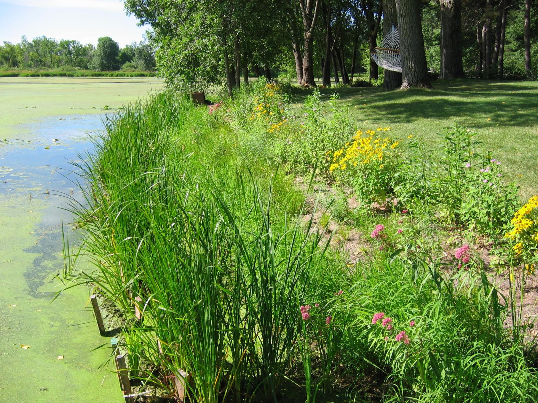
49 Shoreline after two years
50 Shoreline five years after planting
 Coco logs, coco blankets, stakes, mulch Plants")
51 Snake River Private owner (4 years) 400 shoreline on narrow channel Shore eroding 6 /year Boat traffic; seasonal flooding; muskrats Project cost: $5,000 ($12.50/linear shore ft.) Coco logs, coco blankets, stakes, mulch Plants


52 Lay out site

53 Apply mulch for weed control


54 C-125 coco blanket to hold mulch in place during floods


55 Native plant plugs on 1.5 centers

56 Coco log wave break

")
57 Prevegetated plant mats Continuous row (on 2 centers) 5 species

58 After installation

59 One year post-installaton
60 McCarrons Lake 68 acres heavy boat traffic Site on west side maximum fetch = 3,000 ft Shallow water zone 1ft depth out 10 ft from shore All photos in this sequence provided by Bill Bartodziej - RWMWD
61 Wall and turf removed Shore regraded
62 Coconut logs staked on top of the NAG C-350
63 Soil over NAG C-350, seeded, and then covered with C-125
64 Plants are installed through the erosion C ft centers
65 Emergents mainly bulrush, some arrowhead and pickerel plant 1 gallon 3-4 ft centers
66 September 2004
67 Summmer 2005 Shoreline becoming well established, emergents set back by muskrats and waves
68 Summer 2006 Shore stable - Lake sedge enveloping the coconut logs
69 Summer 2006
70 What would we do differently? Use wave breaks in front of emergents Plant a higher percentange of burreed more resistant to muskrat feeding Probably would not need NAG C-350 at the toe of the slope if emergents became well established
71 Take-home messages: The goal is to recreate a gradually sloping shoreline stabilized with native plants It is possible on some sites to reclaim lost shoreline On extreme sites bioengineering may be very costly and/or ineffective
72 Take-home (continued) Use components of the system that are site appropriate Inert bio materials have a limited lifespan make sure you choose plants that will stabilize the site within this time Never underestimate the appetite of muskrats, carp, geese, beavers etc.
73 Resources The Practical Streambank Bioengineering Guide 3.wba NRCS Engineering Field Handbook, Chapter 16: Streambank and Shoreline Bioengineering
74 Resources (continued) University of MN Extension The Shoreland Management Resources Guide Sebastian the Goose encourages natural shorelines
Various options are discussed below.these low cost, low impact interventions can also be applied as general erosion control methods.
 Week 10 River Hydraulics Rehabilitating Urban Waterways (From http://hubpages.com/hub/river-bank-erosion-control-methods) See also the resources placed on Moodle. Water channels should be viewed as a resource
COST AND MAINTENANCE OF LIVING SHORELINES
 COST AND MAINTENANCE OF LIVING SHORELINES Photo: C. Verlinde, University of Florida Sea Grant Extension Debbie L. DeVore South Florida Coastal Program Coordinator What are Living Shorelines? Shoreline
CITY UTILITIES DESIGN STANDARDS MANUAL
 CITY UTILITIES DESIGN STANDARDS MANUAL Book 2 (SW) SW9 June 2015 SW9.01 Purpose This Chapter provides information for the design of open channels for the conveyance of stormwater in the City of Fort Wayne.
EMERGENCY WATERSHED PROTECTION
 Understanding the EMERGENCY WATERSHED PROTECTION Program EWP Program Overview Natural Resources Conservation Service (NRCS) administers the EWP Program EWP responds to emergencies created by natural disasters,
Fisheries and Oceans Canada-Saskatchewan District 2011 Post-Flood Shoreline Restoration and Stabilization Protocol
 Fisheries and Oceans Canada Pêches et Océans Canada Fisheries and Oceans Canada-Saskatchewan District 2011 Post-Flood Shoreline Restoration and Stabilization Protocol 1.0 Introduction Valid until March
The students will be working in and alongside the stream, so safety is a consideration. Suitable sites should have the following characteristics:
 Measuring Stream Banks: Height and Slope Stream bank heights and slopes are of interest because they yield information relevant to bank erosion and stability. A high, steep bank is likely to be unstable
The Teton Creek Restoration Project Summary:
 The Teton Creek Restoration Project Summary: The Teton Creek Restoration Project area extends for approximately one mile upstream from the Cemetery Road Bridge and includes the Aspen Pointe, The Aspens
Waterway Technote Planning
 Waterway Technote Planning Contents Benefits to planning your waterway management 1 Prioritising waterway management where to start? 1 What are your priorities? 1 Start with the best areas or those at
Land Disturbance, Erosion Control and Stormwater Management Checklist. Walworth County Land Conservation Department
 Land Disturbance, Erosion Control and Stormwater Management Checklist Walworth County Land Conservation Department The following checklist is designed to assist the applicant in complying with the Walworth
Index. protection. excavated drop inlet protection (Temporary) 6.50.1 6.51.1. Block and gravel inlet Protection (Temporary) 6.52.1
 6.50.1 6.51.1. Block and gravel inlet Protection (Temporary) 6.52.1") 6 Index inlet protection excavated drop inlet protection (Temporary) 6.50.1 HARDWARE CLOTH AND GRAVEL INLET PROTECTION Block and gravel inlet Protection (Temporary) sod drop inlet protection ROCK DOUGHNUT
6 Index inlet protection excavated drop inlet protection (Temporary) 6.50.1 HARDWARE CLOTH AND GRAVEL INLET PROTECTION Block and gravel inlet Protection (Temporary) sod drop inlet protection ROCK DOUGHNUT
Prepared By: Tom Parker Geum Environmental Consulting, Inc.
 Prepared By: Tom Parker Geum Environmental Consulting, Inc. Topics covered: Definition of riparian and floodplain restoration Floodplain attributes as a basis for developing criteria for restoration designs
Basic Soil Erosion and Types
 Basic Soil Erosion and Types 2015 Wisconsin Lakes Convention Stacy Dehne DATCP Engineer Types of Soil Erosion Rain drop or splash erosion: Erosion preceded by the destruction of the crumb structure due
Did you know that many of
 We All Live Near the Water The Shoreland Stewardship Series Protecting & Restoring Shorelands Number 2 In a sense, we are all waterfront landowners because we all live in a watershed even that storm drain
City of Shelbyville Site Inspection Checklist
 City of Shelbyville Site Inspection Checklist General Information Project Name: KYR10 Permit Number: Date: Project Location: Contractor: Conractor Representative: Inspector's Name: Title: Signature : Weather
Waterway Technote Drains
 Waterway Technote Drains Contents Benefits of good drain practice 1 Are your drains healthy? 2 The Sustainable Dairying Water Accord 3 Planning drain maintenance 3 Fencing and clearing 3 Bank shaping (battering)
1.7.0 Floodplain Modification Criteria
 1.7.0 Floodplain Modification Criteria 1.7.1 Introduction These guidelines set out standards for evaluating and processing proposed modifications of the 100- year floodplain with the following objectives:
How To Plan A Buffer Zone
 Backyard Buffers Protecting Habitat and Water Quality What is a buffer? A buffer (also called a riparian buffer area or zone) is the strip of natural vegetation along the bank of a stream, lake or other
Angora Fire Restoration Activities June 24, 2007. Presented by: Judy Clot Forest Health Enhancement Program
 Angora Fire Restoration Activities June 24, 2007 Presented by: Judy Clot Forest Health Enhancement Program California Tahoe Conservancy Independent California State Agency within the Resources Agency Governed
Post-Wildfire Clean-Up and Response in Houston Toad Habitat Best Management Practices
 Post-Wildfire Clean-Up and Response in Houston Toad Habitat Best Management Practices Purpose The purpose of this document is to provide guidance and recommendations for minimizing potential impacts to
Restoring Anadromous Fish Habitat in Big Canyon Creek Watershed. Summary Report 2002
 Restoring Anadromous Fish Habitat in Big Canyon Creek Watershed Summary Report 2002 DOE/BP-00005268-5 November 2002 This Document should be cited as follows: "Restoring Anadromous Fish Habitat in Big Canyon
Neversink River East Branch
 Neversink River East Branch Management Unit 10 Summary of Post-Flood Recommendations Intervention Level Full restoration of the stream reach including the eroding bank site between Station 38380 and Station
Final Report. Dixie Creek Restoration Project. Funded by Plumas Watershed Forum
 Final Report Dixie Creek Restoration Project Funded by Plumas Watershed Forum Plumas Corporation January 2009 1 Background FR-CRM staff presented this project to the Dixie Valley Landowners Association
Recognizing Wetlands. For additional information contact your local U.S. Army Corps of Engineers office. Pitcher plant.
 US Army Corps of Engineers For additional information contact your local U.S. Army Corps of Engineers office. 1998 Edition Recognizing Wetlands Pitcher plant The information presented here will help you
Floodplain Connectivity in Restoration Design
 Floodplain Connectivity in Restoration Design 2015 Symposium on Restoration in a Contaminated Environment: Lessons Learned and Challenges in Moving Forward Part II April 2015 Karin Boyd Applied Geomorphology,
COLORADO DEPARTMENT OF TRANSPORTATION STORMWATER FIELD INSPECTION REPORT - ACTIVE CONSTRUCTION
 COLORADO DEPARTMENT OF TRANSPORTATION STORMWATER FIELD INSPECTION REPORT - ACTIVE CONSTRUCTION (1) Project Name: (2) Project Contractor: (3) Erosion Control Supervisor/SWMP Administrator: (4) CDOT Project
Standards Oversight Council (SOC) Supporting Technical Standards for Urban and Rural Soil and Water Conservation
 Supporting Technical Standards for Urban and Rural Soil and Water Conservation") Standards Oversight Council (SOC) Supporting Technical Standards for Urban and Rural Soil and Water Conservation 702 E. Johnson Street, Madison, Wisconsin 53703 (608) 441-2677 Fax (608) 441-2676 soc@wlwca.org
Standards Oversight Council (SOC) Supporting Technical Standards for Urban and Rural Soil and Water Conservation 702 E. Johnson Street, Madison, Wisconsin 53703 (608) 441-2677 Fax (608) 441-2676 soc@wlwca.org
What Is Rehabilitation?
 Location of Aggregate Operations Ready Mix Plant Locations Aggregate Locations Cement Terminal Locations What Is Rehabilitation? Rehabilitation is the treatment of land from which aggregate has been excavated
CHAPTER 5 OPEN CHANNEL HYDROLOGY
 5.4 Uniform Flow Calculations 5.4.1 Design Charts CHAPTER 5 OPEN CHANNEL HYDROLOGY Following is a discussion of the equations that can be used for the design and analysis of open channel flow. The Federal
Chapter 3 CULVERTS. Description. Importance to Maintenance & Water Quality. Culvert Profile
 Chapter 3 CULVERTS Description A culvert is a closed conduit used to convey water from one area to another, usually from one side of a road to the other side. Importance to Maintenance & Water Quality
Most informed people realize that cumulative impacts have had
 Welcome to the First Issue of Rivers & Coast! The goal of the new Rivers & Coast newsletter is to keep readers well informed of current scientific understanding behind key environmental issues related
1304.6 Record keeping...12
 ANRC-138.00 Arkansas Natural Resources Commission Rules Governing the Tax Credit Program for the Creation, Restoration, and Conservation of Private Wetland and Riparian Zones Title 13 (Effective February
Appendix A. Lists of Accomplishments and Project Costs. UMRWD 10 Year Plan Update. Appendix A UPPER MINNESOTA RIVER WATERSHED DISTRICT
 UPPER MINNESOTA RIVER WATERSHED DISTRICT Lists of Accomplishments and Project Costs 10 Year Plan Update UMRWD 10 Year Plan Update Page A 1 UMRWD LIST OF ACCOMPLISHMENTS Since its inception in 1967, the
 Coldwater Heritage Partnership Implementation Grant Final Report Morrison Run Watershed Restoration Project Western Pennsylvania Conservancy Project Summary The goal of the Morrison Run Watershed Restoration
Tobique Employment & Training
 APPENDICES 3 Tobique Employment & Training Flood Mitigation July 30, 2012 Overview This proposal outlines the work required and budget for flood mitigation measures on Tobique First Nation which is required
RIPRAP From Massachusetts Erosion and Sediment Control Guidelines for Urban and Suburban Areas http://www.mass.gov/dep/water/laws/policies.
 RIPRAP From Massachusetts Erosion and Sediment Control Guidelines for Urban and Suburban Areas http://www.mass.gov/dep/water/laws/policies.htm#storm Definition: A permanent, erosion-resistant ground cover
Construction Site Inspection Checklist for OHC000004 By making use of some simple Best Management Practices (BMPs) a construction site operator can
 a construction site operator can") Construction Site Inspection Checklist for OHC000004 By making use of some simple Best Management Practices (BMPs) a construction site operator can do his or her share to protect Ohio's water resources
Construction Site Inspection Checklist for OHC000004 By making use of some simple Best Management Practices (BMPs) a construction site operator can do his or her share to protect Ohio's water resources
Erosion and Storm Water Management Unit Mail Stop 620 395 John Ireland Blvd. St. Paul, MN 55155
 Minnesota Department of Transportation Office of Environmental Stewardship Erosion and Storm Water Management Unit Mail Stop 620 395 John Ireland Blvd. St. Paul, MN 55155 Memo Office Tel:651-366-3629 Fax:651-366-3603
MULTI-AGENCY COMPENSATORY MITIGATION PLAN CHECKLIST 1
 MULTI-AGENCY COMPENSATORY MITIGATION PLAN CHECKLIST 1 Mitigation Goals and Objectives o Describe functions lost at impact site o Describe functions to be gained at mitigation site o Describe overall watershed
30-DAY PUBLIC NOTICE CHELSEA RIVER, EAST BOSTON MASSACHUSETTS EMERGENCY STREAMBANK PROTECTION PROJECT
 PUBLIC NOTICE Engineering/Planning 696 Virginia Road Concord, MA 01742 Date: 10 November, 2015 Comment Period Ends: 10 December, 2015 In Reply, Refer To: Robert Russo Or by e-mail: Robert.S.Russo@usace.army.mil
CONSTRUCTION STORMWATER POLLUTION PREVENTION PLAN TEMPLATE
 CONSTRUCTION STORMWATER POLLUTION PREVENTION PLAN TEMPLATE The following template may be used as a general guide for development of a Stormwater Pollution Prevention Plan (SWPPP) for construction activities.
Text and photos: Juha Siekkinen, Life+ Return of Rural Wetlands Cover drawing: Jari Kostet Maps and aerial photos: National Land Survey of Finland
 Life+ Return of Rural Wetlands Pikku Nuoluanjärvi Wetlands, Liminka Text and photos: Juha Siekkinen, Life+ Return of Rural Wetlands Cover drawing: Jari Kostet Maps and aerial photos: National Land Survey
Mission Creek Flood Control & Restoration Project. City of Fremont, Alameda County
 Mission Creek Flood Control & Restoration Project City of Fremont, Alameda County Agenda Background Why are proposed improvements necessary? Proposed project components Challenges Construction schedule/phasing
Goal 1 To protect the public health, safety and property from the harmful effects of natural disasters.
 Plan Framework for Coastal Management The purpose of this element is to provide for the protection of residents and property in within the coastal area of the host community, and to limit expenditures,
Employee Training Plan Farm A
 Employee Training Plan Farm A Table of Contents Training Goals, Objectives, Activities Page Requirements, Standards, Procedures and Practices Training Content Nutrient Management Odor Management Runoff
GLOSSARY OF TERMS CHAPTER 11 WORD DEFINITION SOURCE. Leopold
 CHAPTER 11 GLOSSARY OF TERMS Active Channel The channel that contains the discharge Leopold where channel maintenance is most effective, sediment are actively transported and deposited, and that are capable
How To Assess An Area For Erosion
 SKY BASIN (UPPER CA 1 WATERSHED) EROSION ASSESSMENT Prepared by Kevin Drake, CPESC Integrated Environmental Restoration Services, Inc. August 2014 COMMON GROUND UNCOMMON SOLUTIONS P.O. BOX 7559 2780 LAKE
Prattsville Berm Removal Project. 1.0 Project Location
 Prattsville Berm Removal Project 1.0 Project Location The project site is located between the New York State Route 23 Bridge over the Schoharie Creek and the Schoharie Reservoir. The restoration plan encompassed
Storm Drain Inlet Protection - IP
 Storm Drain Inlet Protection - IP DEFINITION A temporary protective device formed around a storm drain drop inlet to trap sediment. PURPOSE To prevent sediment from entering storm drainage systems, prior
720 Contour Grading. General. References. Resources. Definitions
 720 Contour Grading General Contour grading directs water to a desired point, prevents erosion, provides noise deflection, provides visual fit of the facility into the landscape, and protects desirable
COASTAL DAMAGE INSPECTION SOUTHWEST VITI LEVU, FIJI AFTER CYCLONE SINA
 COASTAL DAMAGE INSPECTION SOUTHWEST VITI LEVU, FIJI AFTER CYCLONE SINA Brendan J. Holden SOPAC Technical Secretariat July 1992 SOPAC Technical Report 148 Prepared for: South Pacific Applied Geoscience
Construction Site Inspection. Inspecting to Keep You in Compliance
 Construction Site Inspection Inspecting to Keep You in Compliance Inspection/Monitoring/Reporting Know if your plan is working Document corrective actions Ketchikan A Contractor that destroys their site
Living on the Fox River
 This information could save you money! Living on the Fox River A Riverfront Property Owners Guide This brochure was developed by Fox River Ecosystem Partnership in cooperation with the Kane-DuPage Soil
Outlet stabilization structure
 Overview of Sedimentation and Erosion Control Practices Practice no. 6.41 Outlet stabilization structure Erosion at the outlet of channels, culverts, and other structures is common, and can cause structural
King County Flood Hazard Management Plan Update Cedar/ Sammamish Rivers. Public Meeting December 5, 2012
 King County Flood Hazard Management Plan Update Cedar/ Sammamish Rivers Public Meeting December 5, 2012 Goals of the Presentation Cedar and Sammamish R. Plan Update Context - Brief summary info about the
SE-10 STORM DRAIN INLET PROTECTION. Objectives
 STORM DRAIN INLET PROTECTION SE-10 Objectives Erosion Control - EC Sediment Control - SE Tracking Control - TC Wind Erosion Control - WE Non-Storm Water Management - NS Waste and Materials Management -
Basic Hydrology. Time of Concentration Methodology
 Basic Hydrology Time of Concentration Methodology By: Paul Schiariti, P.E., CPESC Mercer County Soil Conservation District What is the Time of Concentration? The time it takes for runoff to travel from
Appendix C. Municipal Planning and Site Restoration Considerations
 Appendix C Municipal Planning and Site Restoration Considerations 67 68 Appendix C - Municipal Planning and Site Restoration Considerations This appendix contains best practice standards for site planning
Stream Rehabilitation Concepts, Guidelines and Examples. Objectives. Pierre Y. Julien. Three Laws of Stream Restoration
 Stream Rehabilitation Concepts, Guidelines and Examples Pierre Y. Julien Wuhan 2005 Objectives Part I - Stream restoration and rehabilitation: 1. Present and discuss important concepts, laws, criteria
SECTION 5. Sediment Control Measures
 SECTION 5 Sediment Control Measures 60. STORM DRAIN INLET PROTECTION When Runoff from earth change activities will discharge to a catch basin or storm drain inlet. A newly constructed catch basin or storm
Mitigating Post-Fire Runoff from the Schultz Fire. ASCE/ASHE 2015 Annual State Conference
 Mitigating Post-Fire Runoff from the Schultz Fire ASCE/ASHE 2015 Annual State Conference Revisiting the Schultz Fire Burned ~15,000 acres (23.4 sm) in June/July 2010 2 Revisiting the Schultz Fire Burn
Erosion and Storm Water Management Unit Mail Stop 620 395 John Ireland Blvd. St. Paul, MN 55155
 Minnesota Department of Transportation Office of Environmental Stewardship Erosion and Storm Water Management Unit Mail Stop 620 395 John Ireland Blvd. St. Paul, MN 55155 Memo Office Tel:651-366-3629 Fax:651-366-3603
Stormwater Wetland Design and Construction Mitigation Duke Bitsko. Construction Activities, Schedule and Sequence Tom Ritchie
 September 7, 2011 Welcome Catherine Daly Woodbury DCR Coordination Dan Driscoll Project Background Catherine Daly Woodbury Stormwater Wetland Design and Construction Mitigation Duke Bitsko Construction
The Hudson River Sustainable Shorelines Project
 The Hudson River Sustainable Shorelines Project Jon K. Miller, Ph.D. and Andrew Rella Stevens Institute of Technology And a cast of thousands including: Betsy Blair, Emilie Hauser, Dan Miller, Stuart Findlay,
Ecological Restoration of a Brackish Marsh at Parcel 11, Estate Carolina, St. John
 Ecological Restoration of a Brackish Marsh at Parcel 11, Estate Carolina, St. John Gary Ray, Ph.D. Virgin Forest Restorations For Coral Bay Community Council Aerial of Parcel 11 Brackish Marsh Ecological
Mud in the Water. www.agclassroom.org/ok. Oklahoma Academic Standards. Objective. Background. Resources Needed. Activities
 Mud in the Water Objective Students will learn about soil erosion and water pollution by building a demonstration model from pop bottles and observing the movement of pollutants from soil into water. Background
Flood Risk Reduction and Streambank Restoration
 Mission Creek: Flood Risk Reduction and Streambank Restoration On June 19th, 2012, the residents of Duluth, Minnesota experienced a storm event for the record books. Over the course of 24 hours, approximately
SECTION 104 PREVENTION, CONTROL, AND ABATEMENT OF EROSION AND WATER POLLUTION
 SECTION 104 PREVENTION, CONTROL, AND ABATEMENT OF EROSION AND WATER POLLUTION 104-1 Description. Provide erosion control measures on the project and in areas outside the right-of-way where work is accomplished
Facing an Uncertain Future: Increasing Resilience at Marinas and Harbors. Recreational Boating Educational Conference December 11, 2014
 Facing an Uncertain Future: Increasing Resilience at Marinas and Harbors Recreational Boating Educational Conference December 11, 2014 Operators Face Change and Challenges Environmental Conditions Fluctuating
PRIVATE TREATMENT CONTROL BMP OPERATION AND MAINTENANCE VERIFICATION FORM BIORETENTION FACILITIES, VEGETATED SWALES & HIGHER RATE BIOFILTERS
 BIORETENTION FACILITIES, VEGETATED SWALES & HIGHER RATE BIOFILTERS Check here for Address or phone number change the fiscal year (July 1 June 30), and date(s) maintenance was performed. Under Inspection,
SECTION 7 LANDSCAPE RESTORATION
 SECTION 7 LANDSCAPE RESTORATION 27 7. Landscape and Restoration This section should be read in conjunction with Drawing No.CO8194/A010 Rev. B, Regeneration Strategy As Proposed which can be found at Section
How to Build a Rain Garden at Your Home
 How to Build a Rain Garden at Your Home Virginia gets an average of 45.22 inches of rain a year. Rain that runs off your roof or patio can flow into a sewer pipe, stream or groundwater. Why not put it
PLAN VIEW FOR LAKE OR MARSH FRONT VIEW FOR FLOTATION SILT CURTAIN
 OF WATERWAY PERIMETER CONTROL LESS THAN / THE STREAM/RIVER STEEL FENCE POST ANCHOR TO LAND (TYP.) / DEPTH OF WATER PLOTTED/REVISED:-OCT-0 WIDTH STREAM BANK TEMPORARY ROCK BERM BRIDGE ABUTMENT, CULVERT
Wildlifer 2013 Managing Wildlife on Private Lands
 Master Wildlifer 2013 Managing Wildlife on Private Lands Greg Yarrow, Chair and Professor Natural Resources School of Agricultural, Forest, & Environmental Sciences Clemson University Clemson, South Carolina,
SITE-SPECIFIC BEST MANAGEMENT PRACTICES (BMP) PLAN REVIEW CHECKLIST
 PLAN REVIEW CHECKLIST") This checklist may be used by applicants for encroachment permits, and contractors in development of Site- Specific BMP Plans for projects. plan reviewers will use this checklist to review the Site-Specific
This checklist may be used by applicants for encroachment permits, and contractors in development of Site- Specific BMP Plans for projects. plan reviewers will use this checklist to review the Site-Specific
DEPARTMENT OF THE ARMY SECTION 404 REGIONAL GENERAL PERMIT CHANNEL AND BANK PROTECTION STRUCTURES ON THE SOUTH PLATTE RIVER
 DEPARTMENT OF THE ARMY SECTION 404 REGIONAL GENERAL PERMIT CHANNEL AND BANK PROTECTION STRUCTURES ON THE SOUTH PLATTE RIVER Permit Expires: December 31, 2017 Regional General Permit No. 87-01 Issuing Office:
Increasing water availability through juniper control.
 Tim Deboodt, OSU Crook County Extension Agent 498 SE Lynn Blvd. Prineville, OR 97754 541-447-6228 Tim.deboodt@oregonstate.edu Increasing water availability through juniper control. Throughout the region
Table 4.9 Storm Drain Inlet Protetion Applicable for
 BMP C220: Storm Drain Inlet Protection Purpose To prevent coarse sediment from entering drainage systems prior to permanent stabilization of the disturbed area. Conditions of Use Type of Inlet Protection
What We Do: Wetlands, Wildlife Habitat & Flood Hazards in the Root River Watershed
 What We Do: Wetlands, Wildlife Habitat & Flood Hazards in the Root River Watershed presented by Ceil Strauss, State Floodplain Manager DNR Ecological & Water Resources 1 EWR Roles In Floodplains Regulatory:
Forest Road Construction and Maintenance
 Forest Roads 1 Forest Road Construction and Maintenance CONTENTS INTRODUCTION...5 The Benefits of Guidelines...5 Considerations...7 Design Outcomes To Maintain Soil Productivity...10 UPLAND FOREST ROADS...11
Ruby River Grayling - Gravel Spawning Beds Monitoring Report January 2008
 Ruby River Grayling - Gravel Spawning Beds Monitoring Report January 2008 In partnership with Montana Department of Fish, Wildlife, and Parks (FWP), American Wildlands, and Wildlife Forever, the Madison
Subsidence Mitigation Through Rice Cultivation Research Project Goals:
 Twitchell Island rice growing area Subsidence Mitigation Through Rice Cultivation Research 1. Determine the viability of different rice growing methods within the Delta. 2. Determine the rates/amounts
Mine Plan of Operations Reclamation Bond Checklist
 Mine Plan of Operations Reclamation Bond Checklist NOTE: This checklist is provided to assist the operator in calculating the engineering and environmental costs required to properly stabilize, reclaim,
GREEN INFRASTRUCTURE DESIGNS BIOSWALE/HYBRID DITCH
 GREEN INFRASTRUCTURE DESIGNS BIOSWALE/HYBRID DITCH JULY 2015 BIOSWALE/HYBRID DITCH SCALABLE TOOL AND DESIGN TEMPLATE This tool and associated design files are one section of a larger toolkit: Green Infrastructure
Temporary Erosion-Control Measures
 A Guide to Temporary Erosion-Control Measures for Contractors, Designers and Inspectors June 2001 North Dakota Department of Health Division of Water Quality A Guide to Temporary Erosion-Control Measures
RESTORING streams to reduce flood loss
 RESTORING streams to reduce flood loss Flood Loss Reduction the Natural Way Flood disasters have become a regular Floods can devastate local occurrence. One in your community may have communities. threatened
SITE-SPECIFIC BEST MANAGEMENT PRACTICES (SSBMP) PLAN/STORM WATER POLLUTION PREVENTION PLAN (SWPPP) REVIEW CHECKLIST
 PLAN/STORM WATER POLLUTION PREVENTION PLAN (SWPPP) REVIEW CHECKLIST") This checklist may be used by applicants for encroachment permits, and contractors in development of Site Specific Best Management Practice (SSBMP) Plans or Storm Water Pollution Prevention Plans (SWPPP)
This checklist may be used by applicants for encroachment permits, and contractors in development of Site Specific Best Management Practice (SSBMP) Plans or Storm Water Pollution Prevention Plans (SWPPP)
BRIDGES ARE relatively expensive but often are
 Chapter 10 Bridges Chapter 10 Bridges Bridg Bridges -- usually the best, but most expensive drainage crossing structure. Protect bridges against scour. BRIDGES ARE relatively expensive but often are the
Sample Punch List. Garth Ruffner Landscape Architect (916) 797-2576. Page 1 of 5
 797-2576. Page 1 of 5") Sample Punch List This document is provided primarily for landscape contractors who have not previously worked with Garth and would like to know what issues are frequently addressed by site observation
Sample Punch List This document is provided primarily for landscape contractors who have not previously worked with Garth and would like to know what issues are frequently addressed by site observation
CHAPTER 3A Environmental Guidelines for STREAM CROSSING BY ALL-TERRAIN VEHICLES
 GOVERNMENT OF NEWFOUNDLAND AND LABRADOR DEPARTMENT OF ENVIRONMENT AND LABOUR CHAPTER 3A Environmental Guidelines for STREAM CROSSING BY ALL-TERRAIN VEHICLES WATER RESOURCES MANAGEMENT DIVISION Water Investigations
Chesapeake Bay Preservation Area (CBPA) in Virginia Beach, Virginia. The Resource Protection Area (RPA) and Buffers The First 100 Feet
 in Virginia Beach, Virginia. The Resource Protection Area (RPA) and Buffers The First 100 Feet") Chesapeake Bay Preservation Area (CBPA) in Virginia Beach, Virginia The Resource Protection Area (RPA) and Buffers The First 100 Feet How Large is the Chesapeake Bay Watershed? The Chesapeake Bay Watershed
Chesapeake Bay Preservation Area (CBPA) in Virginia Beach, Virginia The Resource Protection Area (RPA) and Buffers The First 100 Feet How Large is the Chesapeake Bay Watershed? The Chesapeake Bay Watershed
FREQUENTLY ASKED QUESTIONS Biomass Harvest Guidelines
 FREQUENTLY ASKED QUESTIONS Biomass Harvest Guidelines What do Biomass Harvest Guidelines offer? They offer recommendations to manage forest-, brush- and open- land with the intent to protect water, timber,
WETLAND RESTORATION PROGRAM WATER ACT APPROVAL ADMINISTRATIVE GUIDE
 WETLAND RESTORATION PROGRAM WATER ACT APPROVAL ADMINISTRATIVE GUIDE May 24, 2005 Table of Contents Introduction...3 Definitions...3 Types of Wetland Restorations...4 Re-Contouring...4 Engineered...4 Water
Streambank and Shoreline Protection Manual
 Streambank and Shoreline Protection Manual Produced january 2002 Lake County Stormwater Management Commission Lake County Planning, Building and Development Department U.S.D.A. - Natural Resources Conservation
How To Manage Wildlife And Wildlife Damages At Earthen Dams
 Dam Owner s Guide To Animal Impacts On Earthen Dams FEMA L-264 / September 2005 Twenty-five states across the U.S. can write headlines of unsafe dam operations caused by nuisance wildlife intrusions,
Aitkin County Shoreland Homeowner s Guide to Lake Stewardship
 Aitkin County Shoreland Homeowner s Guide to Lake Stewardship 2007 This Shoreland Homeowner s Guide to Lake Stewardship was produced as a joint project of the Aitkin County Environmental Services/Aitkin
Wetland Vocabulary Organizer
 Wetland Vocabulary Organizer Vocabulary Word Definition Wetland Picture Species Nutrients Sediment Groundwater Habitat Vocabulary Word Wetland Wetland Vocabulary Organizer Key Definition is an area that,
Integrated Pest Management, Erosion and Sedimentation Control, and Landscape Management Plan
 Integrated Pest Management, Erosion and Sedimentation Control, and Landscape Management Plan Introduction Conventional site and landscape management can have adverse impacts on the surrounding environment
Chapter 11 Site Rehabilitation and Stabilization
 Chapter 11 Site Rehabilitation and Stabilization Chapter 11 Layout: Part 1 - Page 131 Planning Site Rehab Part 2 - Page 132 Controlling Runoff and Capturing Sediment Part 3 - Page 133 Rehab for Crossings
Water Quality and Water Usage Surveys
 Appendix 1 Water Quality and Water Usage Surveys This appendix contains copies of the Water Quality Survey and the Lake Usage Survey that we used to complete the watershedbased community assessments. We
Scour and Scour Protection
 Design of Maritime Structures Scour and Scour Protection Steven A. Hughes, PhD, PE Coastal and Hydraulics Laboratory US Army Engineer Research and Development Center Waterways Experiment Station 3909 Halls