INDIAN REGIONAL NAVIGATION SATELLITE SYSTEM (IRNSS) AND GPS-AIDED GEO AUGMENTED NAVIGATION SYSTEM (GAGAN)
|
|
|
- Esmond Hines
- 7 years ago
- Views:
Transcription
1 INDIAN REGIONAL NAVIGATION SATELLITE SYSTEM (IRNSS) AND GPS-AIDED GEO AUGMENTED NAVIGATION SYSTEM (GAGAN) S. Sayeenathan Assoc. Director (Satnav) Satellite Communication and Navigation Program Indian Space Research Organisation HQ. INDIA ICG -8, DUBAI, UAE November 2013

2 INDIAN SATELLITE NAVIGATION PROGRAM
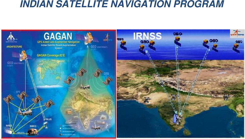
3 GAGAN (GPS Aided GEO Augmented Navigation) OBJECTIVES To provide Satellite-based Navigation services with accuracy and integrity required for civil aviation applications over Indian Air Space. Better Air Traffic Management over Indian Airspace.

4 GAGAN (GPS Aided GEO Augmented Navigation) GAGAN is a Satellite Based Augmentation System being implemented by India based on GPS GAGAN jointly implemented by ISRO and Airports Authority of India (AAI) Compatible and Interoperable with other SBAS Provides Seamless navigation GAGAN implementation in two phases: GAGAN TDS (Technology Demonstration System) GAGAN FOP (Final Operation Phase)
 GAGAN FOP (Final")
5 GAGAN Configuration in TDS INRES Ground Segment AR #1 INRES AR #1 Ahamedabad Jammu Delhi INRES AR #1 INRES AR #1 Guwahati 8 INRES: 2 INREEs 1 INMCC 1 INLUS 1 ring of OFC (7 INRES) 1 VSAT link (GPB) Calcutta INRES Space Segment INRES AR #1 AR #1 INMARSAT-4F1 FES #1 CR #1 INMCC INLUS Bangalore AR #1 INRES AR #1 Port Blair AR = Access Router CR = Core Router -DCN circuit lines FES = Fast Ethernet Switch Triuandrum INRES AR #1 GAGAN Signal-In-Space Verified and validated through flight-trail from Hyderabad to Bangalore. On-board GAGAN Receiver position compared with DGPS position to demonstrate SBAS capability.

6 GAGAN Operational System 3 GEO Satellites Users GPS constellation 3 Uplink stations 2 Control Centres 15 Reference Stations 2 Data communication networks

7 GAGAN Intended Services High position accuracies with integrity (APV- 1/1.5 and RNP 0.1) over a wide geographical area such as the Indian Airspace. These position accuracies to be simultaneously made available to all airports and air fields in Indian FIR, enabling satellite based landing of aircraft fitted with SBAS receivers. To provide fuel efficient air corridors. Better upper Air-space management over India.

8 GAGAN Current Status To be Launched The GAGAN Signal-in- Space is available through GSAT-8 and GSAT-10 GAGAN Stability tests were successfully completed The certification process for GAGAN signals by Directorate General of Civil Aviation is under progress

9 Indian Regional Navigation Satellite System (IRNSS) IRNSS is an independent regional navigation system. 7 satellite constellation and ground segment. Coverage area is about 1500 km beyond Indian territory. Estimated horizontal position accuracy of 20m in over India and adjoining areas.

10 IRNSS - Objectives Reliable Position, Navigation and Timing services over India and its neighbourhood To provide fairly good accuracy to the user. Most of the constellation is seen by user all the time. Ionosphere correction messages to user.

11 IRNSS CONFIGURATION

12 IRNSS SPACE SEGMENT Consists of 7 Satellites, 3 in Geo- Stationary orbit at 32.5, 83 and East. 4 Satellites in GEO Synchronous orbit at inclination of 29 with Longitude crossing at 55 and East. IRNSS Satellites are to be launched by the Indian launcher PSLV. The first Satellite launched on 1 st July The full constellation will be realized by the end of 2015.

13 IRNSS CDMA Ranging Stations (IRCDR) ISRO Navigation Centre (INC) IRNSS Range & Integrity Monitoring Stations (IRIMS) IRNSS Network Timing Facility (IRNWT) IRNSS Data Communication Network (IRDCN) IRNSS Spacecraft Control Facility (IRSCF)
 IRNSS Spacecraft Control")
14 IRNSS USER SEGMENT The user segment consists of IRNSS receivers operating in Single Frequency ( L5 or S band) Dual Frequency (L5 and S band) Single frequency and dual frequency receivers shall receive both SPS and RS signals. SPS is for civilian users. RS signal is meant for authorised users.

15 IRNSS SIGNALS IRNSS signals are transmitted using the following frequencies and modulations. L5 : MHz S : MHz Modulation schemes: BPSK(1) and BOC (5,2)

16 IRNSS STATUS IRNSS-1A satellite was launched on 1 st July 2013 and the satellite was positioned at 55 E with inclination o f 27. Subsequently the in-orbit Test was successfully completed. Navigation and Ranging Payload performance is normal. Phase 1 ground stations have been established. Realtime navigation operations started at INC.

17 IRNSS STATUS (Contd..) CDMA ranging from all four IRCDR stations and one way ranging from eight IRM stations being carried out for orbit determination. Laser ranging has been successfully carried out from Yaragadee (Australia) Changchun (China), Wettzell (Germany), Grasse(France) Graz (Austria) & Zimmerwald (Switzerland) stations. ISRO acknowledges the laser ranging support provided by these stations with thanks and appreciation. Navigation signal performance is being monitored.
 Changchun (China), Wettzell (Germany),")
18 Thank you for your Attention

GAGAN-FOP/PMR-05. Indian SBAS System - GAGAN
 GAGAN-FOP/PMR-05 Indian SBAS System - GAGAN GAGAN GPS Aided GEO Augmented Navigation (GAGAN) is India s regional Satellite Based Augmentation System (SBAS) India is working towards attaining APV 1 capability
A forum to discuss Global Navigation Satellite Systems (GNSS) to benefit people around the world
 to benefit people around the world") A forum to discuss Global Navigation Satellite Systems (GNSS) to benefit people around the world The International Committee on Global Navigation Satellite Systems (ICG) The United Nations General Assembly
A forum to discuss Global Navigation Satellite Systems (GNSS) to benefit people around the world The International Committee on Global Navigation Satellite Systems (ICG) The United Nations General Assembly
GAGAN - The Indian satellite based augmentation system
 Indian Journal of Radio & Space Physics Vol. 36, August 2007, pp. 293-302 GAGAN - The Indian satellite based augmentation system K N Suryanarayana Rao ISRO Satellite Centre, Airport Road, Bangalore 560
GENERAL INFORMATION ON GNSS AUGMENTATION SYSTEMS
 GENERAL INFORMATION ON GNSS AUGMENTATION SYSTEMS 1. INTRODUCTION Navigation technologies with precision approach and landing systems, for civilian and military purposes, enable aircrafts to perform their
The Evolution of the Global Navigation Satellite System (GNSS) Spectrum Use
 Spectrum Use") The Evolution of the Global Navigation Satellite System (GNSS) Spectrum Use Spectrum Management 2012 National Spectrum Management Association Scott Pace (with thanks to Chris Hegerty, MITRE) Space Policy
The Evolution of the Global Navigation Satellite System (GNSS) Spectrum Use Spectrum Management 2012 National Spectrum Management Association Scott Pace (with thanks to Chris Hegerty, MITRE) Space Policy
a Brief Background DEFINITION
 GNSS FOR AVIATION a Brief Background ANC informal briefing DEFINITION GNSS: A worldwide position and time determination ti system that t includes one or more satellite constellations, aircraft receivers
CNS/ATM SYSTEMS IN INDIA
 CNS/ATM SYSTEMS IN INDIA Presentation at ICG02 4 th Sept-7 th Sept 2007, Bangalore M.IRULAPPAN General Manager (GNSS) Over Indian Airspace (AAI) provides Air navigation services (ANS) infrastructure Air
Status, Development and Application
 Federal Space Agency GLONASS GLONASS Status, Development and Application Sergey G. Revnivykh International Committee on Global Navigation Satellite Systems (ICG) Second Meeting, September 4-7, 2007, Bangalore,
The European GNSS Programmes EGNOS and Galileo
 The European GNSS Programmes EGNOS and Galileo 6th ICG Conference Pieter De Smet European Commission 5 September 2011 1. State of Play of EGNOS 2. State of Play of Galileo 5 September, 2011 The European
Indian Space Programme -Update on activities (Feb 2015)
") Indian Space Programme -Update on activities (Feb 2015) Vinay K Dadhwal India Director, National Remote Sensing Centre (NRSC), INDIAN SPACE RESEARCH ORGANISATION 52 nd Science & Technology Sub-Committee,
Indian Space Programme -Update on activities (Feb 2015) Vinay K Dadhwal India Director, National Remote Sensing Centre (NRSC), INDIAN SPACE RESEARCH ORGANISATION 52 nd Science & Technology Sub-Committee,
MSAS current status. Japan Civil Aviation Bureau S TSAT A ATELLITE-BASED S UGMENTATION. MTSAT Satellite-based Augmentation System
 MSAS current status Japan Civil Aviation Bureau Civil Aviation Bureau Ministry of Land, Infrastructure and Transport 1 Contents Overview of MSAS MSAS Status Process for MSAS Commissioning Results of OT&E
Greg Keel P.Eng. Parallel Geo Services gkeel@nanaimo.ark.com
 Greg Keel P.Eng. Parallel Geo Services gkeel@nanaimo.ark.com Presentation Outline GNSS: Global Navigation Satellite System GPS: overview, current signals, modernization GLONASS: history (rise fall rise),
CAR/SAM STRATEGY FOR THE EVOLUTION OF AIR NAVIGATION SYSTEMS
 CNS/ATM/SG/1 Appendix C to the Report on Agenda Item 4 4C-1 APPENDIX C CAR/SAM STRATEGY FOR THE EVOLUTION OF AIR NAVIGATION SYSTEMS First Edition Rev 2.0 TABLE OF CONTENTS Page 1. INTRODUCTION... 2 1.1
Development of BeiDou Navigation Satellite System
 The 7th Meeting of International Committee on GNSS Development of BeiDou Navigation Satellite System China Satellite Navigation Office November 5, 2012 Beijing, China Part Ⅰ Development Plan Part Ⅱ System
What, Why and How. Hosted Payloads: A guide to commercially hosted government payloads from the Hosted Payload Alliance. www.hostedpayloadalliance.
 Hosted Payloads: What, Why and How A guide to commercially hosted government payloads from the Hosted Payload Alliance The Hosted Payload Alliance (HPA) is a satellite industry alliance formed in 2011
ILS Replacement. ACI World Safety Seminar. 18 19 November 2008 Kempinski Hotel Beijing Lufthansa Centre
 ILS Replacement Xiaosong Xiao, PhD Tetra Tech, Inc. Orlando, USA Contents: Ground-Based Navigation ILS Approach GNSS/SBAS Approach Comparisons between ILS and GNSS Example: Cost Analysis Between LAAS and
Doc 9849 AN/457. Approved by the Secretary General and published under his authority. First Edition 2005. International Civil Aviation Organization
 Doc 9849 AN/457 Global Navigation Satellite System (GNSS) Manual Approved by the Secretary General and published under his authority First Edition 2005 International Civil Aviation Organization AMENDMENTS
[3] beautiful visualisation of the satellites positions by HSR / ICOM
![[3] beautiful visualisation of the satellites positions by HSR / ICOM](/thumbs/40/21057207.jpg "[3] beautiful visualisation of the satellites positions by HSR / ICOM") GPS (Introduction) MSE, Rumc, GPS, 1 Terms NAVSTAR GPS ( Navigational Satellite Timing and Ranging - Global Positioning System) is a GNSS (Global Navigation Satellite System), developed by the US-DoD in
GPS (Introduction) MSE, Rumc, GPS, 1 Terms NAVSTAR GPS ( Navigational Satellite Timing and Ranging - Global Positioning System) is a GNSS (Global Navigation Satellite System), developed by the US-DoD in
CONTENTS. Satellite Fleet. Türksat 2A. Türksat 3A. Türksat 4A. Türksat 4B. Türksat VSAT
 www.turksat.com TURKSAT A.S. Turksat, one of the leading operators in the satellite communication business, offers flexible solutions by providing its customers with cable and wireless broadcasting, high-speed
Rocket Science Made Simple
 Rocket Science Made Simple Satellite Connectivity For Aviation Explained George Nicola 1 and Michele Franci 2 Inmarsat, London, EC1Y 1AX, United Kingdom Any satellite communication system is required to
Post Processing Service
 Post Processing Service The delay of propagation of the signal due to the ionosphere is the main source of generation of positioning errors. This problem can be bypassed using a dual-frequency receivers
Satellite Communication Systems. mgr inż. Krzysztof Włostowski Instytut Telekomunikacji PW chrisk@tele.pw.edu.pl
 Satellite Communication Systems mgr inż. Krzysztof Włostowski Instytut Telekomunikacji PW chrisk@tele.pw.edu.pl Satellite Communication Satellite Communication combines the missile and microwave technologies
DESIMETERSYSTEM FOR HØYNØYAKTIG POSISJONERING OG NAVIGASJON
 DESIMETERSYSTEM FOR HØYNØYAKTIG POSISJONERING OG NAVIGASJON John A. Vint Survey Manager Thales GeoSolutions Norge AS Hønefoss, 7. november 2003 Scope of Presentation Introduction Summary of GPS Errors.
 www.turksat.com TURKSAT A.S. Turksat, one of the leading operators in the satellite communication business, offers flexible solutions by providing its customers with cable and wireless broadcasting,
GEOGRAPHIC INFORMATION SYSTEMS Lecture 21: The Global Positioning System
 GEOGRAPHIC INFORMATION SYSTEMS Lecture 21: The Global Positioning System The Global Positioning System - recognize that GPS is only one of several Global Navigation Satellite Systems (GNSS) - the Russian
Propsim enabled Aerospace, Satellite and Airborne Radio System Testing
 www.anite.com Propsim enabled Aerospace, Satellite and Airborne Radio System Testing Anite is now part of Keysight Technologies Realistic and repeatable real-time radio channel emulation solutions for
Communication, Navigation, Surveillance (CNS) engineers and executives of Airports Authority of India
 engineers and executives of Airports Authority of India") Communication, Navigation, Surveillance (CNS) engineers and executives of Airports Authority of India CNS Officers Guild 1 Airports Authority of India (AAI) is entrusted with responsibility of providing
Communication, Navigation, Surveillance (CNS) engineers and executives of Airports Authority of India CNS Officers Guild 1 Airports Authority of India (AAI) is entrusted with responsibility of providing
SYSTEM GLOBAL NAVIGATION SATELLITE SYSTEM LANDING TECHNOLOGY/PRODUCT DEVELOPMENT
 GLOBAL NAVIGATION SATELLITE SYSTEM LANDING SYSTEM The aviation industry is developing a new positioning and landing system based on the Global Navigation Satellite System (GNSS). The GNSS landing system
The European Satellite Navigation Programmes EGNOS and Galileo
 The European Satellite Navigation Programmes EGNOS and Galileo Olivier Crop European GNSS Agency (GSA) Paris, 17 March 2014 20 March, 2014 The European GNSS Programmes 2 Basics of Satellite Navigation
PLM PRODUCT INFORMATION
 PLM PRODUCT INFORMATION Agricultural Equipment UK & ROI Precision Farming Reference UK- PLM_03_13 Date: 1st May 2013 Announcing the new RangePoint RTX Correction Service RangePoint RTX is a GPS and GLONASS
Enabling RTK-like positioning offshore using the global VERIPOS GNSS network. Pieter Toor GNSS Technology Manager
 Enabling RTK-like positioning offshore using the global VERIPOS GNSS network Pieter Toor GNSS Technology Manager Introduction PPP/RTK Positioning Techniques PPP-AR Technology Presentation Overview PPP-AR
Visualizing Wireless Transfer of Power: Proposal for A Five-Nation Demonstration by 2020. ISDC2012: Washington DC, May 26, 2012
 Visualizing Wireless Transfer of Power: Proposal for A Five-Nation Demonstration by 2020 Don Flournoy Ohio University Brendan Dessanti & Narayanan Komerath Georgia Institute of Technology ISDC2012: Washington
Inmarsat & Global Xpress
 Inmarsat & Global Xpress Global Mobile Broadband Laura Roberti laura.roberti@inmarsat.com Bangkok, 19 th September 2014 Inmarsat in L-band: an overview Worldwide coverage Land, sea, and air mobile services,
Summary. Space Debris Risks. Insurance VS Space Debris - Property insurances - Liability insurances. Impact of regulations on insurance
 Summary Summary Space Debris Risks Insurance VS Space Debris - Property insurances - Liability insurances Impact of regulations on insurance 2 Space Debris Risks Space Debris Risks Increasing of space
PNT Evolution: Future Benefits and Policy Issues. Scott Pace Director, Space Policy Institute George Washington University Washington, D.C.
 PNT Evolution: Future Benefits and Policy Issues Scott Pace Director, Space Policy Institute George Washington University Washington, D.C. 5 November 2009 GPS is a Critical Component of the Global Information
ANALOG SATELLITE COMMUNICATION : Introduction, Base band analog (Voice) signal,
 signal,") Section-A PRINCIPLES OF SATELLITE COMMUNICATION: Evolution & growth of communication satellite, Synchronous satellite, Satellite frequency allocation & Band spectrum, advantages of satellite communication,
Section-A PRINCIPLES OF SATELLITE COMMUNICATION: Evolution & growth of communication satellite, Synchronous satellite, Satellite frequency allocation & Band spectrum, advantages of satellite communication,
INSTALLATION OF MODE 'A' / 'C' AND MODE S TRANSPONDERS.
 GOVERNMENT OF INDIA OFFICE OF DIRECTOR GENERAL OF CIVIL AVIATION TECHNICAL CENTRE, OPP SAFDARJANG AIRPORT, NEW DELHI CIVIL AVIATION REQUIREMENTS SECTION 2 - AIRWORTHINESS SERIES 'R', PART IV DATED 8 TH
Radio Technical Commission for Maritime Services. GPS Update. Bob Markle RTCM Arlington, VA USA. NMEA Convention & Expo 2010
 Radio Technical Commission for Maritime Services GPS Update NMEA Convention & Expo 2010 Bob Markle RTCM Arlington, VA USA What is RTCM? International non-profit scientific, professional and membership
Block 0: Capabilities within our Grasp
 Block 0: Capabilities within our Grasp 1 ICAO Block Upgrades Assumptions and Constraints Current ATM infrastructure and procedures will not support forecasted traffic growth Implementation of major ATM
SATELLITE COMMUNICATION
 SATELLITE COMMUNICATION By Gaurish Kumar Tripathi. 1.0 INTRODUCTION: The use of satellite in communication system is very much a fact of everyday in life. This is evidence by the many homes, which are
Competition and Regulatory Deficit in Civil Aviation Sector in India
 Competition and Regulatory Deficit in Civil Aviation Sector in India Mukesh Kacker (IAS) Director General Structure Importance of Civil Aviation in India s Growth Civil Aviation Sector in India Investment
AIAA-2004-5820 Distributed Operation of a Military Research Micro Satellite Using the Internet
 AIAA-2004-5820 Distributed Operation of a Military Research Micro Satellite Using the Internet Chris Jackson * Surrey Satellite Technology Ltd., Guildford, England, GU2 7XH, UK Major Timothy J. Lawrence,
2.4G Bluetooth Datalink & ipad Ground Station User Guide V1.12
 2.4G Bluetooth Datalink & ipad Ground Station User Guide V1.12 Thank you for purchasing DJI products. Please strictly follow this user guide to mount and connect the 2.4G Bluetooth Datalink, install the
Introduction. Satellite navigation Overview. The Space Segment
 Introduction Satellite navigation is a leading-edge technology which allows anyone with a receiver to determine their position very accurately at any time by picking up signals from a constellation of
Surveillance in Canadian Airspace Today and in the Future
 Surveillance in Canadian Airspace Today and in the Future Jeff Dawson Director, Standards and Procedures, NAV CANADA ATM Global, Dubai UAE - 5 October 2015 Outline NAV CANADA Overview Evolution of Canadian
Introduction to Inmarsat and the Global Xpress Ka Band System
 Introduction to Inmarsat and the Global Xpress Ka Band System Presentation for Caribbean ICT Roadshow Trinidad and Tobago September February, 2010 17, 2010 www.inmarsat.com www.inmarsat.com Agenda Brief
Second International Symposium on Advanced Radio Technologies Boulder Co, September 8-10, 1999
 Second International Symposium on Advanced Radio Technologies Boulder Co, September 8-10, 1999 Overview of Satellite Communications Tim Pratt Center for Wireless Telecommunications Virginia Tech History
CNS / ATM R&D Activities in Korea
 CNS / ATM R&D Activities in Korea 2010. 11. 10 D.M. Kim Korea Aerospace Research Institute Contents I Introduction to KARI II CNS/ATM Projects in Korea III Future Plan & Summary Introduction to KARI National
Tel: 91 44 5209 3054 Fax: 91 44 2450 0250
 Galileo Potential in Indian Market Ravindra Babu, Srinath Pydimarri, Ramachandran, Smitha Menon, Sumonta Mazumder Wipro Technologies, Bangalore 560 095. India E-mail: swarna.babu@wipro.com Tel: 91 44 5209
Education and Training in GNSS
 Education and Training in GNSS Mourad BOUZIANI Department of Geodesy and Surveying ESGIT, IAV Hassan II, Morocco Cordinator of GNSS Master Curriculum CRASTE-LF, Affiliated to the United Nations OUTLINE
Indian Journal of Advances in Computer & Information Engineering Volume.1 Number.1 January-June 2013, pp.1-5 @ Academic Research Journals.
 Cellular System Rajat Chugh, Parag Jasoria, Tushar Arora, Nitin Ginotra and Vivek Anand V Semester, Department of Computer Science and Engineering, Dronacharya College of Engineering, Khentawas, Farukhnagar,
C-S TEAM. Page 1 of 5
 Title: Medium/large vehicle tracking system Primary POC: Jacoba Auret Organization: C-S Team (Cape Peninsula University of Technology-Stellenbosch University) POC email: 14807599@sun.ac.za Need We exist
Environmental Monitoring: Guide to Selecting Wireless Communication Solutions
 Environmental Monitoring: Guide to Selecting Wireless Communication Solutions By: Scott South Published in WaterWorld, January 2005 (Page 48) Rapidly growing demands for information and increased productivity
Current and Planned Global and Regional Navigation Satellite Systems and Satellite-based Augmentations Systems
 UNITED NATIONS OFFICE FOR OUTER SPACE AFFAIRS Current and Planned Global and Regional Navigation Satellite Systems and Satellite-based Augmentations Systems International Committee on Global Navigation
MULTI-GNSS DEMONTRATION CAMPAIGN IN ASIA OCEANIA REGION
 UNITED NATIONS INTERNATIONAL MEETING ON THE APPLICATIONS OF GLOBAL NAVIGATION SATELLITE SYSTEMS PRESENTATION SESSION 2: INTERNATIONAL INITIATIVES/EXPERIENCES MULTI-GNSS DEMONTRATION CAMPAIGN IN ASIA OCEANIA
1. Introduction. FER-Zagreb, Satellite communication systems 2011/12
 1. Introduction Topics History Characteristics of satellite communications Frequencies Application 1 History Arthur C. Clark suggested in 1945. Earth coverage with 3 geostationary satellites. On 4th of
Iridium Update. Cross Polar Working Group. Mike Hooper Senior Business Manager - Aviation 05/12/15
 Iridium Update Cross Polar Working Group Mike Hooper Senior Business Manager - Aviation 05/12/15 Iridium - Unique Global Network 66 cross-linked, low earth orbit (LEO) satellites Only fully global voice
The NASA Global Differential GPS System (GDGPS) and The TDRSS Augmentation Service for Satellites (TASS)
 and The TDRSS Augmentation Service for Satellites (TASS)") The Global Differential GPS System (GDGPS) and The TDRSS Augmentation Service for Satellites (TASS) Yoaz Bar-Sever, Larry Young, Frank Stocklin, Paul Heffernan and John Rush s Global Differential GPS System
The Global Differential GPS System (GDGPS) and The TDRSS Augmentation Service for Satellites (TASS) Yoaz Bar-Sever, Larry Young, Frank Stocklin, Paul Heffernan and John Rush s Global Differential GPS System
Overview of LEO Satellite Systems
 Overview of LEO Satellite Systems Christopher Redding Institute for Telecommunication Sciences National Telecommunications and Information Administration Boulder, CO credding@its. @its.bldrdoc.gov 1999
3.4 SCS Technologies for Container Integrity: Track/Trace or Positioning technologies
 3.4 SCS Technologies for Container Integrity: Track/Trace or Positioning technologies It seems evident that if authorities are concerned about the potential misuse of containers by criminals or terrorists,
CIVIL AVIATION REQUIREMENTS SECTION 9 AIR SPACE AND AIR TRAFFIC MANAGEMENT SERIES 'D' PART VI
 GOVERNMENT OF INDIA OFFICE OF DIRECTOR GENERAL OF CIVIL AVIATION TECHNICAL CENTRE, OPP SAFDARJANG AIRPORT, NEW DELHI CIVIL AVIATION REQUIREMENTS SECTION 9 AIR SPACE AND AIR TRAFFIC MANAGEMENT SERIES 'D'
EPN, seminar AFIS, september 2013 Instrument approach procedures, PBN, GNSS
 EPN, seminar AFIS, september 2013 Instrument approach procedures, PBN, GNSS By Frédéric BOISARD, AFIS-O at Cholet LFOU Thanks to Mrs Morgane BARDIEUX (DGAC DSAC/O) and to Mrs Corinne BOUSQUET (DGAC - DSNA/DTI)
International Civil Aviation Organization PERFORMANCE MONITORING OF ADS-B EQUPPED AIRCRAFTS IN INDIAN AIRSPACE
 ADS-B SITF/13 IP/12 International Civil Aviation Organization AUTOMATIC DEPENDENT SURVEILLANCE BROADCAST SEMINAR AND THIRTEENTH MEETING OF PROVISIONAL AUTOMATIC DEPENDENT AGENDA SURVEILLANCE BROADCAST
Global Positioning System (GPS) Automated Vehicle Location (AVL) Geographic Information System (GIS) and Routing/Scheduling System
 Automated Vehicle Location (AVL) Geographic Information System (GIS) and Routing/Scheduling System") Global Positioning System (GPS) Automated Vehicle Location (AVL) Geographic Information System (GIS) and Routing/Scheduling System Jeff Tsai Program Director Institute for Transportation Research and Education
Global Positioning System (GPS) Automated Vehicle Location (AVL) Geographic Information System (GIS) and Routing/Scheduling System Jeff Tsai Program Director Institute for Transportation Research and Education
INTEGRITY AND CONTINUITY ANALYSIS OCTOBER TO DECEMBER 2013 QUARTERLY REPORT FROM GPS. Integrity and Continuity Analysis 08/01/14 08/01/14 08/01/14
 INTEGRITY AND CONTINUITY ANALYSIS FROM GPS OCTOBER TO DECEMBER 2013 QUARTERLY REPORT Prepared by: M Pattinson (NSL) 08/01/14 Checked by: L Banfield (NSL) 08/01/14 Approved by: M Dumville (NSL) 08/01/14
INTERNATIONAL CIVIL AVIATION ORGANIZATION GUIDE FOR GROUND BASED AUGMENTATION SYSTEM IMPLEMENTATION
 INTERNATIONAL CIVIL AVIATION ORGANIZATION GUIDE FOR GROUND BASED AUGMENTATION SYSTEM IMPLEMENTATION May 2013 -2- Foreword The Ground Based Augmentation System (GBAS) is being developed and implemented
OPTIMIZING A GLOBAL SATELLITE CONSTELLATION FOR AIS AND MARITIME DOMAIN AWARENESS ABSTRACT BACKGROUND
 OPTIMIZING A GLOBAL SATELLITE CONSTELLATION FOR AIS AND MARITIME DOMAIN AWARENESS ABSTRACT Although relatively new, Satellite Automatic Identification System (S-AIS) technology has fundamentally changed
u-blox comprehensive approach to multi-gnss positioning
 WHITEPAPER u-blox comprehensive approach to multi-gnss positioning locate, communicate, accelerate Whitepaper by: Carl Fenger, Communications Manager, u-blox Uffe Pless, Product Manager, u-blox May 2012
 IMES (Indoor Messaging System) A Proposal for New Indoor Positioning System Presenter: Dr. Dinesh Manandhar GNSS Technologies Inc., Japan Third Meeting of the International Committee on Global Navigation
Satellite Basics. Benefits of Satellite
 Satellite Basics Benefits of Satellite People need access to enterprise-class, high-speed voice, video and data applications wherever they happen to be. Satellite connectivity has the power to drive communications
Trimble Productivity: Making GPS Solutions Simple and Affordable. Trimble Site Positioning Systems:
 Trimble Productivity: Making GPS Solutions Simple and Affordable Trimble Site Positioning Systems: Smart GPS Antennas and Modular GPS Receivers Unmatched jobsite performance GPS: How Does It Work? Trimble
HYLAS 1 Programme Overview
 HYLAS 1 Programme Overview David Bestwick October 2011 AGENDA 1. The HYLAS 1 System 2. Products 3. Application Areas of Interest THE HYLAS 1 SYSTEM The HYLAS 1 System Architecture HYLAS 1 Coverage A single
Secure communications Reference
 Secure communications Reference Danil Melekhin / Getty Images 54 Innovative cloud architecture for air traffic control A unique solution from Rohde & Schwarz can help national and international air traffic
LOG OF REVISIONS Revision Page FAA Date of Number Number(s) Description Approved Approval A All Initial Release K.
 Description Approved Approval A All Initial Release K.") LOG OF REVISIONS Revision Page FAA Date of Number Number(s) Description Approved Approval A All Initial Release K. Campbell* 4/4/00 B 5, 10 Remove SKYWATCH and add GTX 330 TIS G. Baker* 11/21/02 C All
LOG OF REVISIONS Revision Page FAA Date of Number Number(s) Description Approved Approval A All Initial Release K. Campbell* 4/4/00 B 5, 10 Remove SKYWATCH and add GTX 330 TIS G. Baker* 11/21/02 C All
Tracking IRNSS Satellites. for Multi-GNSS Positioning in Finland
 Tracking IRNSS Satellites for Multi-GNSS Positioning in Finland Figure 1. IRNSS Primary service area, satellite locations and relative position of Finland. Above, photo of IRNSS-1B satellite in clean room
'l'ehisat. A IfICROSATBLLI'l'E SYS'l'EH FOR AlJ'rONOHOUS ENVIRONIfElI'.rAL IfONI'l'ORING SERVICR
 'l'ehsat A fcrosatbll'l'e SYS'l'EH FOR AlJ'rONOHOUS ENVRONfEl'.rAL fon'l'orng SERVCR Brunella Paves! (1), Giuseppe Rondinelli (1) Nikolaos Balteas (2) (1) f!lesp1zo S.p.a. - Via 'l'iburtlna 965-00156 ROJa,
COMMISSION OF THE EUROPEAN COMMUNITIES. Draft COMMISSION DECISION
 COMMISSION OF THE EUROPEAN COMMUNITIES Brussels, C (2008) Draft COMMISSION DECISION of [ ] on harmonised conditions of spectrum use for the operation of mobile communication services on aircraft (MCA services)
Switch Fabric Implementation Using Shared Memory
 Order this document by /D Switch Fabric Implementation Using Shared Memory Prepared by: Lakshmi Mandyam and B. Kinney INTRODUCTION Whether it be for the World Wide Web or for an intra office network, today
GOVERNMENT OF INDIA DIRECTORATE GENERAL OF CIVIL AVIATION CENTRAL EXAMINATION ORGANISATION EAST BLOCK III, R.K. PURAM, NEW DELHI 110066
 GOVERNMENT OF INDIA DIRECTORATE GENERAL OF CIVIL AVIATION CENTRAL EXAMINATION ORGANISATION EAST BLOCK III, R.K. PURAM, NEW DELHI 110066 CA 9 F APPLICATION FORM FOR FLIGHT RADIO TELEPHONE OPERATOR S LICENCE
Improved user experiences are possible with enhanced FM radio data system (RDS) reception
 reception") Improved user experiences are possible with enhanced FM radio data system (RDS) reception Aravind Ganesan, Senior Systems Engineer, and Jaiganesh Balakrishnan, Senior Member of Technical Staff, Wireless
Improved user experiences are possible with enhanced FM radio data system (RDS) reception Aravind Ganesan, Senior Systems Engineer, and Jaiganesh Balakrishnan, Senior Member of Technical Staff, Wireless
Pre-4th Mission Idea Contest, 3 rd UNISEC Global Meeting 4 July 2015, Takeda Hall, Asano Campus University of Tokyo, Japan
 Pre-4th Mission Idea Contest, 3 rd UNISEC Global Meeting 4 July 2015, Takeda Hall, Asano Campus University of Tokyo, Japan Presented by BENDOUKHA, SIDI AHMED DURAN, ADELAIDA CASTILLO 1 Outline of the Presentation:
Learning about GPS and GIS
 Learning about GPS and GIS Standards 4.4 Understand geographic information systems (G.I.S.). B12.1 Understand common surveying techniques used in agriculture (e.g., leveling, land measurement, building
Truck Automation for the Ready Mixed Concrete Industry. Michael J. Hoagland (205) 879-3282 ext. 1164 mhoagland@commandalkon.com
 879-3282 ext. 1164 mhoagland@commandalkon.com") Truck Automation for the Ready Mixed Concrete Industry Michael J. Hoagland (205) 879-3282 ext. 1164 mhoagland@commandalkon.com Session Agenda What is GPS and How does it work? Auto Signaling Explained
Truck Automation for the Ready Mixed Concrete Industry Michael J. Hoagland (205) 879-3282 ext. 1164 mhoagland@commandalkon.com Session Agenda What is GPS and How does it work? Auto Signaling Explained
GLOBAL POSITIONING SYSTEM IN TRANSPORTATION PLANNING
 GLOBAL POSITIONING SYSTEM IN TRANSPORTATION PLANNING N.Thilagavathi and G.N.Mallikarjuna Rao Sona College of Technology Salem KEY WORDS:. 1. INTRODUCTION Global Positioning System, a worldwide satellite
GPS Tracking Solution GPS GSM Tracker
 2013 GPS Tracking Solution GPS GSM Tracker Robust solution for tracking your Assets, Cars, Buses, Trucks, Fleet, Shipment, Children, Pets and more with web based tracking from anywhere in the world through
Technical Article Developing Software for the CN3 Integrated GPS Receiver
 Technical Article Developing Software for the CN3 Integrated GPS Receiver 1 Intermec Technologies Table of Contents INTRODUCTION... 3 AN OVERVIEW OF GPS TECHNOLOGY... 3 What is GPS?... 3 How GPS works...
Defining Connectivity at Sea
 Shipping Insight, Stamford CT Oct 2015 Defining Connectivity at Sea Shane Rossbacher SVP Business Development, Inmarsat Maritime A brief history The industry leader for more than 35 years 1979 The International
Using TETRA over satellite for disaster relief in HAITI
 Using TETRA over satellite for disaster relief in HAITI Peter Clemons, Board Member, TETRA Association Director of Communications, Teltronic TETRA Congress Middle East Abu Dhabi, January 25 th 2011 1/27/2011
Mobile Wireless Overview
 Mobile Wireless Overview A fast-paced technological transition is occurring today in the world of internetworking. This transition is marked by the convergence of the telecommunications infrastructure
DIRECTORATE OF AIR TRAFFIC MANAGEMENT RAJIV GANDHI BHAWAN, NEW DELHI-110003 [File No. AAI/20012/131/2012-ARI (NOC)]
![DIRECTORATE OF AIR TRAFFIC MANAGEMENT RAJIV GANDHI BHAWAN, NEW DELHI-110003 [File No. AAI/20012/131/2012-ARI (NOC)]](/thumbs/39/19182733.jpg "DIRECTORATE OF AIR TRAFFIC MANAGEMENT RAJIV GANDHI BHAWAN, NEW DELHI-110003 [File No. AAI/20012/131/2012-ARI (NOC)]") DIRECTORATE OF AIR TRAFFIC MANAGEMENT RAJIV GANDHI BHAWAN, NEW DELHI-110003 [File No. AAI/20012/131/2012-ARI (NOC)] Doc. Id: ED/ATM/2013/2001201/ATMC/PROC ATMC AIR TRAFFIC MANAGEMENT CIRCULAR NO. 02 of
DIRECTORATE OF AIR TRAFFIC MANAGEMENT RAJIV GANDHI BHAWAN, NEW DELHI-110003 [File No. AAI/20012/131/2012-ARI (NOC)] Doc. Id: ED/ATM/2013/2001201/ATMC/PROC ATMC AIR TRAFFIC MANAGEMENT CIRCULAR NO. 02 of
Rockwell Collins ARINC MultiLink SM flight tracking service
 Rockwell Collins ARINC MultiLink SM flight tracking service Background Each time a highly publicized event involving a commercial airline occurs, the aviation community begins to clamor for automated transponders
Satellite-based navigation systems and their application in Kyrgyz Republic
 United Nations/United Arab Emirates/United States of America Workshop on the Applications of Global Navigation Satellite Systems Satellite-based navigation systems and their application in Kyrgyz Republic
MANAGEMENT SYSTEM FOR A FLEET OF VEHICLES BASED ON GPS. João André Correia Telo de Oliveira
 MANAGEMENT SYSTEM FOR A FLEET OF VEHICLES BASED ON GPS João André Correia Telo de Oliveira Author Affiliation(s) Instituto Superior Técnico, University of Lisbon, Portugal ABSTRACT This dissertation was
MEASAT Satellite Systems Sdn. Bhd.
 MEASAT Satellite Systems Sdn. Bhd. Business Continuity Planning in the Satellite Industry August 2010 Regional Satellite Operator of the Year Excellence in Satellite Management September 2008 1 MEASAT
8. Communications Subsystem
 PM-1.1-03 Rev C 8. Communications Subsystem The GOES-NOP spacecraft communications subsystem provides requisite conditioning, transmission, reception, and routing of mission data signals and telemetry
GNSS integrity monitoring for the detection and mitigation of interference
 GNSS integrity monitoring for the detection and mitigation of interference Dr. Shaojun Feng Centre for Transport Studies Outline GNSS vulnerability GNSS integrity monitoring Cases study GAARDIAN ERAIM
Indian Diplomacy At Work
 Indian Diplomacy At Work 50 YEARS OF INDO-FRENCH SPACE CO-OPERATION BRINGING BENEFITS TO MANKIND 50 YEARS OF INDO-FRENCH SPACE CO-OPERATION Bringing Benefits to Mankind A time-tested partnership India
Computers Are Your Future. 2006 Prentice-Hall, Inc.
 Computers Are Your Future 2006 Prentice-Hall, Inc. Computers Are Your Future Chapter 3 Wired and Wireless Communication 2006 Prentice-Hall, Inc Slide 2 What You Will Learn... ü The definition of bandwidth
ADS-B over Satellite Global Air Traffic Surveillance from Space
 www.dlr.de Chart 1 ADS-B over Satellite Global Air Traffic Surveillance from Space ATM World Congress, March 11 th 2015 in Madrid K. Werner, German Aerospace Center (DLR) Institute of Flight Guidance T.
GENSO. A Global Educational Network for Satellite Operations
 GENSO A Global Educational Network for Satellite Operations A Typical Student Space Segment Satellite in Low-Earth Orbit, often Sun Synchronous, Low-power transmitters, Standard communications protocols